59


p-ear1-04 TDD (for hearing and speech impaired only): (651) 282-5332
Printed on recycled paper containing 30% fibers from paper recycled by consumers
ENVIRONMENTAL ASSESSMENT WORKSHEET Note to reviewers: The Environmental Assessment Worksheet (EAW) provides information about a project that may have the potential for significant environmental effects. This EAW was prepared by the Minnesota Pollution Control Agency (MPCA), acting as the Responsible Governmental Unit (RGU), to determine whether an Environmental Impact Statement (EIS) should be prepared. The project proposer supplied reasonably accessible data for, but did not complete the final worksheet. Comments on the EAW must be submitted to the MPCA during the 30-day comment period which begins with notice of the availability of the EAW in the Minnesota Environmental Quality Board (EQB) Monitor. Comments on the EAW should address the accuracy and completeness of information, potential impacts that are reasonably expected to occur that warrant further investigation, and the need for an EIS. A copy of the EAW may be obtained from the MPCA by calling (651) 297-8510. An electronic version of the completed EAW is available at the MPCA Web site http://www.pca.state.mn.us/news/eaw/index.html#open-eaw. 1. Project Title: Victoria Interceptor and Lift Station 15 2. Proposer: City of Victoria 3. RGU: Minnesota Pollution Control Agency Contact Person Cara L. Geheren, P.E. Contact Person Jessica Ebertz and Title City Engineer and Title Project Manager Address 7951 Rose Street, P. O. Box 36 Address 520 Lafayette Road North Victoria, Minnesota 55386 St. Paul, Minnesota 55155 Phone (952) 443-2782 Phone (651) 296-8011 Fax (952) 443-2110 Fax (651) 297-2343 E-mail [email protected] E-mail [email protected] 4. Reason for EAW Preparation:
EIS Scoping
Mandatory EAW
X
CitizenPetition
RGU Discretion
Proposer Volunteered
If EAW or EIS is mandatory give EQB rule category subpart number and name: Minn. R. 4410.4300,
subp. 18. Wastewater systems
5. Project Location: County Carver City Victoria N 1/2 Section 14, 15 Township 116N Range 24W

Victoria Interceptor and Lift Station 15 Environmental Assessment Victoria, Minnesota 2 Worksheet
Attachments and Figures for the EAW: Attachments: • Attachment A: U.S. Army Corps of Engineers (USACE) Section 404 Permit; • Attachment B: Minnesota Department of Natural Resources (DNR) Permit to Cross Protected Waters; • Attachment C: DNR Natural Heritage Letter; • Attachment D: State Historical Preservation Office (SHPO) Response E-mail and Figures Showing
Historical Sites; and • Attachment E: Minnesota’s Federally-listed Threatened, Endangered, Proposed and Candidate Species’
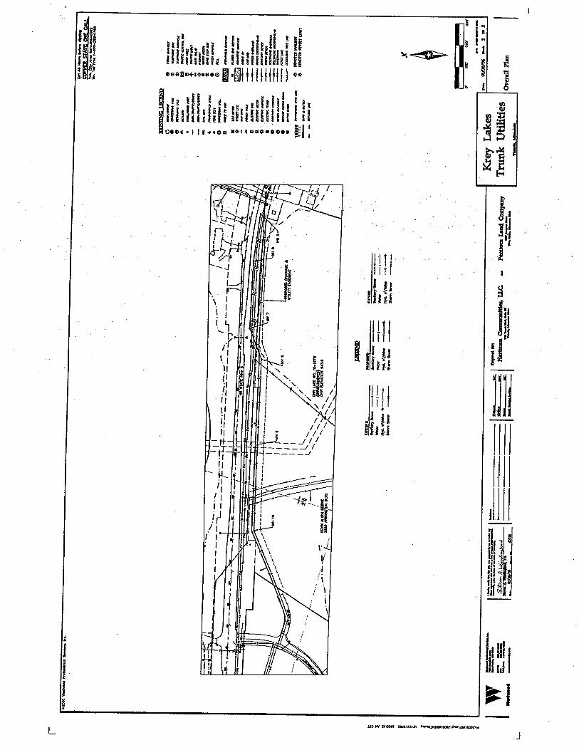
County Distribution List. Figures: • Figure 1: State Map with Project Location; • Figure 2: County Map with Project Location; • Figure 3: Site Map; • Figure 4: Lift Station Site Map; • Figure 5: Aerial Site Map; • Figure 6: U.S. Geological Survey (USGS) 7.5 Minute Map; • Figure 7: National Wetlands Inventory Map of Overall Area; • Figure 8: National Wetlands Inventory Map, West End of Project; • Figure 9: National Wetlands Inventory Map, East End of Project; and • Figure 10: Soils Map.
6. Description:
a. Provide a project summary of 50 words or less to be published in the EQB Monitor. The city of Victoria (City) is proposing to construct a new sanitary trunk sewer and lift station, and a trunk watermain, in conjunction with the Krey Lakes Area Development, to serve a portion of the City recently annexed and not currently served by utilities.
b. Give a complete description of the proposed project and related new construction. Attach additional sheets as necessary. Emphasize construction, operation methods and features that will cause physical manipulation of the environment or will produce wastes. Include modifications to existing equipment or industrial processes and significant demolition, removal or remodeling of existing structures. Indicate the timing and duration of construction activities. The City is proposing, in conjunction with the Krey Lakes Area Development, to construct a new sanitary trunk sewer and trunk watermain, to serve a portion of the City not currently served by utilities. The project is discussed in the City’s Comprehensive Sanitary Sewer Plan and in the Sanitary Lift Stations d and 15 Feasibility Report dated October 24, 2005. The proposed project was initiated because the Krey Lakes area is in design for a residential neighborhood. The City completed an Alternative Urban Areawide Review (AUAR), dated December 5, 2003, for the expansion and development of the area southwest of the City. This area includes the recent and future annexation of property into the City as per the orderly annexation agreement with Laketown Township and the City’s Comprehensive Plan adopted in 2004. The proposed utilities will be constructed in street/highway right of way or dedicated utility easement. The proposed sanitary sewer construction includes relocation and update of an existing lift station south of the intersection of State Highway 5 and County State Aid Highway (CSAH) 11. The new lift station

Victoria Interceptor and Lift Station 15 Environmental Assessment Victoria, Minnesota 3 Worksheet
will be located outside of the State right of way. The sanitary forcemain pipe installed out of the lift station will be a 14-inch inside diameter pipe, 2,100 linear feet in length from the relocated lift station to a Metropolitan Council Environmental Services (MCES) manhole on the north side of Steiger Lake Lane, about 1,000 feet east of the intersection of State Highway 5 and Steiger Lake Lane. This forcemain will run from the relocated lift station under State Highway 5, then east along State Highway 5 in the north right of way, under Steiger Lake Lane, and then along the south right of way of Steiger Lake Lane until just before it reaches the MCES manhole connection, where it crosses under Steiger Lake Lane again to be connected to the MCES manhole. The forcemain will be placed in the south right of way along Steiger Lake Lane to keep it more than 50 feet away from an existing well. A sanitary manhole will be installed along the MCES manhole with a 21-inch connection pipe, as requested by the MCES. Installation of the pipe will be open cut along State Highway 5 and directional drilled along and under Steiger Lake Lane and under CSAH 11 with the possibility of directional drilling this entire length. The pipe under State Highway 5 will be placed in a casing jacked under the road. The City will request alternate bids to directional drill this entire section, as noted above, in an effort to minimize impact to the surrounding area. The proposed lift station will have two incoming pipes. One is the existing four-inch gravity sewer pipe coming from the north under State Highway 5. The other is the proposed 21-inch inside diameter gravity trunk main pipe running west from the lift station, for a total of 5,600 linear feet. The first 2,000 linear feet run parallel to State Highway 5 in a dedicated easement into the proposed Krey Lakes Development. The pipe will then run south and west to the western edge of the development, 3,600 linear feet in either dedicated easements or rights of way. The installation of the pipe will be open cut except for 600 feet west of the relocated lift station, where it will be directionally drilled under a wetland along State Highway 5. The proposed watermain will be a 12-inch inside diameter pipe, 8,000 linear feet in total length. It will connect to an existing 12-inch watermain stub west of the intersection of Rose Street and Steiger Lake Lane. From this connection, the watermain will be installed in the northern rights of way of Steiger Lake Lane and State Highway 5, running west under CSAH 11, then south under State Highway 5 to the relocated lift station. This segment will be 2,400 linear feet. From the lift station the watermain will run west in the dedicated easement 2,000 feet along State Highway 5 and into the Krey Lakes Development. The pipe will then run south and west to the western edge of the development, 3,600 linear feet, in either dedicated easements or rights of way. The installation of the pipe will be open cut except for 600 feet west of the relocated lift station, where it will be directionally drilled under a wetland along State Highway 5 and under CSAH 11. The pipe under State Highway 5 will be placed in a casing jacked under the road. The City will request alternate bids to directional drill the section from the lift station east to the connection of the existing 12-inch stub. Any further developments that may occur as a result of the proposed project will need to meet the land use requirements of the City’s Comprehensive Plan, as approved by the City and the Metropolitan Council in 2004. Also, any further development beyond the scope of this study may require the completion of a separate EAW or AUAR at the time of project proposal. Construction is anticipated to begin in 2006, and should be finished within eight months. During construction, the contractor will be required to maintain access for all property owners and businesses to their properties. Construction will involve temporary erosion and sedimentation controls, clearing

Victoria Interceptor and Lift Station 15 Environmental Assessment Victoria, Minnesota 4 Worksheet
and grubbing, grading, excavating, trenching, utility installation, backfilling, compaction, and re-vegetation. The equipment to be used will include standard construction equipment, such as backhoes, trucks, graders, compactors, bobcats, cranes, and loaders.
c. Explain the project purpose; if the project will be carried out by a governmental unit, explain the need for the project and identify its beneficiaries. The proposed project was initiated to service a residential development consisting of 173 new homes (Krey Lakes Development). There will be a mix of residential and public land uses in the development. The City has demonstrated an ongoing demand for additional housing stock, as it expands according to the orderly annexation of surrounding properties.
d. Are future stages of this development including development on any outlots planned or likely to happen? Yes No
If yes, briefly describe future stages, relationship to present project, timeline and plans for environmental review. Although the City projects that the area will grow and additional development will most likely take place, there are no current plans for future developments.
e. Is this project a subsequent stage of an earlier project? Yes No If yes, briefly describe the past development, timeline and any past environmental review.
7. Project Magnitude Data Total Project Area (acres) or Length (miles) 1.52 Number of Residential Units: Unattached Attached maximum units per building Commercial/Industrial/Institutional Building Area (gross floor space): total square feet Indicate area of specific uses (in square feet): Office Manufacturing Retail Other Industrial Warehouse Institutional Light Industrial Agricultural Other Commercial (specify) Building height If over 2 stories, compare to heights of nearby buildings 8. Permits and approvals required. List all known local, state and federal permits, approvals and financial
assistance for the project. Include modifications of any existing permits, governmental review of plans, and all direct and indirect forms of public financial assistance including bond guarantees, Tax Increment Financing and infrastructure.
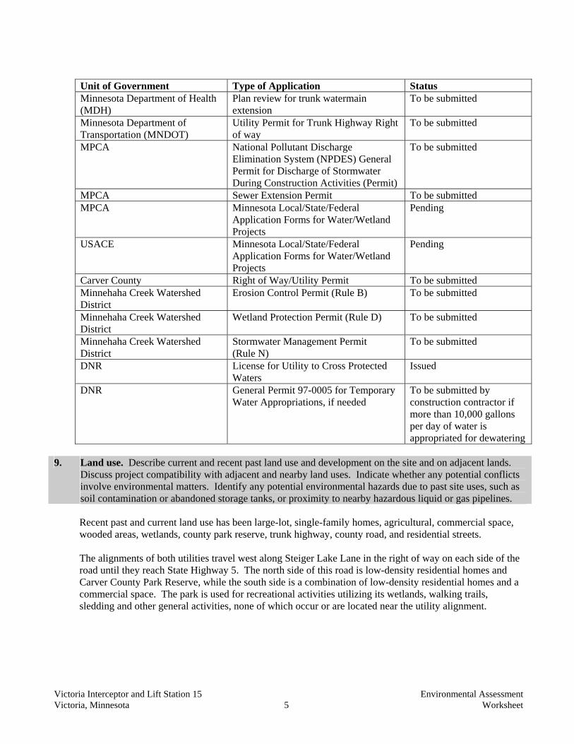
Victoria Interceptor and Lift Station 15 Environmental Assessment Victoria, Minnesota 5 Worksheet
Unit of Government Type of Application Status Minnesota Department of Health
(MDH) Plan review for trunk watermain extension
To be submitted
Minnesota Department of Transportation (MNDOT)
Utility Permit for Trunk Highway Right of way
To be submitted
MPCA National Pollutant Discharge Elimination System (NPDES) General Permit for Discharge of Stormwater During Construction Activities (Permit)
To be submitted
MPCA Sewer Extension Permit To be submitted MPCA Minnesota Local/State/Federal
Application Forms for Water/Wetland Projects
Pending
USACE Minnesota Local/State/Federal Application Forms for Water/Wetland Projects
Pending
Carver County Right of Way/Utility Permit To be submitted Minnehaha Creek Watershed
District Erosion Control Permit (Rule B) To be submitted
Minnehaha Creek Watershed District
Wetland Protection Permit (Rule D) To be submitted
Minnehaha Creek Watershed District
Stormwater Management Permit (Rule N)
To be submitted
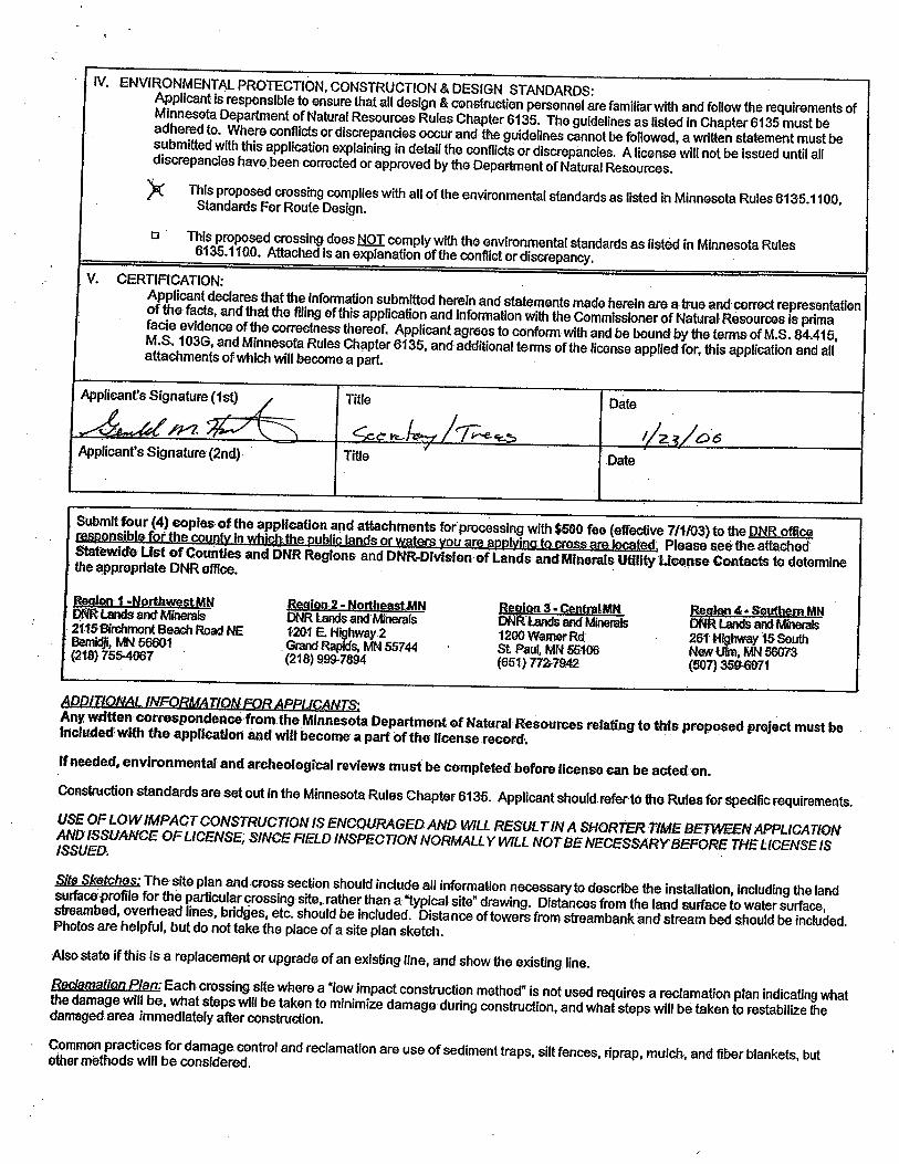
DNR License for Utility to Cross Protected Waters
Issued
DNR General Permit 97-0005 for Temporary Water Appropriations, if needed
To be submitted by construction contractor if more than 10,000 gallons per day of water is appropriated for dewatering
9. Land use. Describe current and recent past land use and development on the site and on adjacent lands.
Discuss project compatibility with adjacent and nearby land uses. Indicate whether any potential conflicts involve environmental matters. Identify any potential environmental hazards due to past site uses, such as soil contamination or abandoned storage tanks, or proximity to nearby hazardous liquid or gas pipelines. Recent past and current land use has been large-lot, single-family homes, agricultural, commercial space, wooded areas, wetlands, county park reserve, trunk highway, county road, and residential streets. The alignments of both utilities travel west along Steiger Lake Lane in the right of way on each side of the road until they reach State Highway 5. The north side of this road is low-density residential homes and Carver County Park Reserve, while the south side is a combination of low-density residential homes and a commercial space. The park is used for recreational activities utilizing its wetlands, walking trails, sledding and other general activities, none of which occur or are located near the utility alignment.

Victoria Interceptor and Lift Station 15 Environmental Assessment Victoria, Minnesota 6 Worksheet
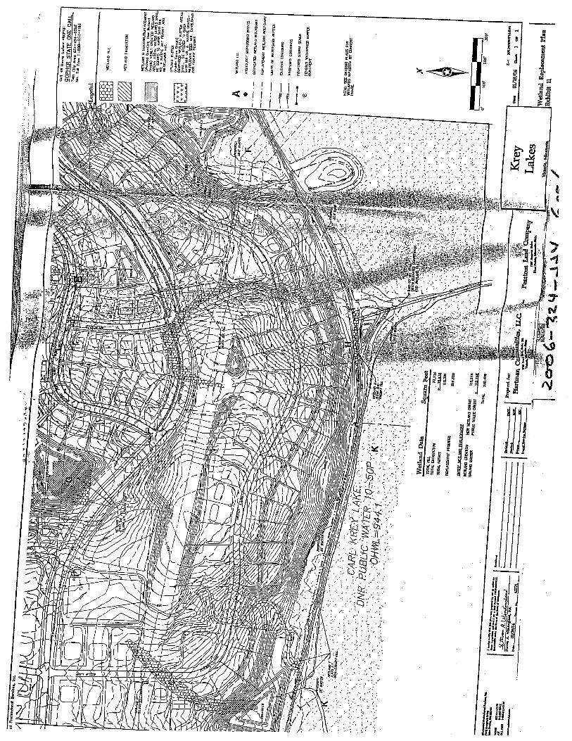
Once the utilities reach State Highway 5, the utilities continue to the west in the northern right of way until they cross under CSAH 11, then turn south and cross under State Highway 5 to the relocated lift station. This area abuts Carver County Park Reserve and another commercial business. To maintain access to the business and to keep CSAH 11 open, both of the utility pipes will be directionally drilled under the driveway and the CSAH. The lift station will be moved from its current location in the right of way of State Highway 5 and onto the corner of the adjacent property (see Figure 4). The existing lift station does not have the capacity, nor can it be retrofitted, for the ultimate projected flows from future development of the western and southwestern parts of the City. The MCES forcemain that the existing lift station site is connected to is at or near capacity, which requires the connection of the sanitary forcemain out of the proposed lift station to the larger gravity pipe along Steiger Lake Lane. Since the existing lift station cannot be retrofitted, a new lift station must be built. MNDOT has indicated that State Highway 5 will be expanded in the near future to four lanes and that if a new lift station is to be built, they would like it to be located outside of the right of way of the State Highway. The lift station will be located on a portion of the adjacent property that is not usable by the owner because it is isolated from the rest of the property by DNR Lake 10-197W. It will be located in a dedicated easement, outside of the wetland/lake. The other properties in this area are commercial. The utilities continue west from the lift station in a dedicated easement outside of the right of way of State Highway 5 until they reach the Krey Lakes Development. In this area, the utilities pass under DNR Lake 10-197W for about 600 feet then turn into an open area. Both utilities will be directionally drilled under the lake to minimize any impacts. The open area will remain an open space in an outlot. Once the utilities extend beyond the outlot, they will be placed under new residential streets in rights of way constructed as part of the Krey Lakes Development. This area was agricultural, but will be developed into medium-density, residential homes.
10. Cover Types. Estimate the acreage of the site with each of the following cover types before and after development:
Before After Before After Types 1-8 wetlands 0.41 0.41 Lawn/landscaping 0.10 0.10 Wooded/forest 0.00 0.00 Impervious Surfaces 0.14 0.14 Brush/grassland 2.16 2.16 Other (describe) 0.00 0.00 Cropland 9.92 9.92 TOTAL 12.73 12.73 11. Fish, Wildlife, and Ecologically Sensitive Resources. a. Identify fish and wildlife resources and habitats on or near the site and describe how they would be
affected by the project. Describe any measures to be taken to minimize or avoid impacts. A review of the DNR’s Web site was completed for endangered and threatened species. Minnesota’s Federally Listed Threatened, Endangered, Proposed and Candidate Species County Distribution List showed that Carver County is within the known or historic range of the Bald Eagle, but no known nesting sites are in the immediate area. The review also included the Natural Communities and Rare Species of Carver, Hennepin and Scott Counties map. This map showed no threatened or rare species in the vicinity of the proposed project. Other fish and wildlife species in the proposed project area are likely to include those species common to agricultural and developing areas. Species might include fox, deer, muskrats, raccoons, rabbits, mice and other small rodents, geese, ducks, raptors, a
Victoria Interceptor and Lift Station 15 Environmental Assessment Victoria, Minnesota 7 Worksheet
variety of other common bird species, and small reptiles. Amphibians may be present in wetland areas. Temporary impacts on wildlife will include the disruptive effects of construction, including excavation, stockpiling of soils and materials, noise, potential erosion and sedimentation, and vehicle movement. Habitat and individual animals may be destroyed by the actual excavation or placement of stockpiled earth or bedding. Some small species may be forced to leave their territories within the proposed project area and compete with established species in nearby areas. Larger species may be forced to relocate to portions of their territories that are not impacted. Seasonal activities, such as nesting or mating, may be disrupted or curtailed, depending upon the season of construction and the species. The part of the project that will provide trunk services to the edge of the Krey Lakes Development will not permanently displace wildlife. Habitat destroyed during construction will be restored to pre-existing contours and re-vegetated. The Krey Lakes Development and any other development enabled by this project will impact the diversity and population of species in the area. As land use is converted from agricultural and open space to residential, the types and numbers of wildlife will change to species that tolerate the near presence of humans, their residences, and their activities.
b. Are any state (endangered or threatened) species, rare plant communities or other sensitive ecological resources such as native prairie habitat, colonial waterbird nesting colonies or regionally rare plant communities on or near the site? Yes No
If yes, describe the resource and how it would be affected by the project. Indicate if a site survey of the resources has been conducted and describe the results. If the DNR Natural Heritage and Nongame
Research program has been contacted give the correspondence reference number. ERDB 20060645 Describe measures to minimize or avoid adverse impacts.
A review of the Natural Heritage Database was performed by DNR staff for reports of rare plant or animal species or other significant natural features within a one-mile radius of the proposed project and the proposed Krey Lakes Development. The database search results are included in Attachment C. The Natural Heritage Database has three known occurrences of rare species or native plant communities within one mile of the proposed project area. However, based on the nature and location of the proposed project, the DNR staff does not believe the project would affect any known occurrences of rare features (see Attachment C).
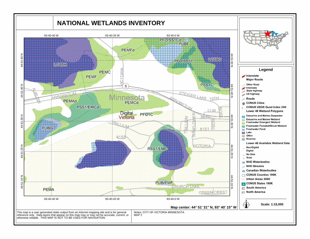
12. Physical Impacts on Water Resources. Will the project involve the physical or hydrologic alteration (dredging, filling, stream diversion, outfall structure, diking, and impoundment) of any surface waters such as a lake, pond, wetland, stream or drainage ditch? Yes No If yes, identify water resource affected. Describe alternatives considered and proposed mitigation measures to minimize impacts. Give the DNR Protected Waters Inventory (PWI) number(s) if the water resources affected are on the PWI. Although there will be no permanent physical impacts on any water resources, a DNR wetland/lake will be crossed by directional drilling. The wetland impacted, DNR Lake 10-197W, is protected and the DNR has issued a license, number 114-065-6335, for the utilities to cross. The area of the DNR Lake is typical of a wetland/marshland area, with areas ranging from moist surface areas to standing water, all with typical vegetation. All impacts to the wetland will be during construction and will be temporary. To

Victoria Interceptor and Lift Station 15 Environmental Assessment Victoria, Minnesota 8 Worksheet
minimize impacts, these waters will be crossed by directional drilling and any areas disturbed will be seeded with a native wetland seed mixture. Special measures will be taken to protect the wetlands from erosion and sedimentation during and after construction while vegetation is getting established. Installation of high flow silt fences and bio-rolls will be installed prior to construction and maintained throughout construction until turf has been established. As part of the NPDES Permit required by the MPCA, temporary and permanent erosion and sediment control plans will be prepared for approval. In addition, Storm Water Pollution Prevention Plans will be submitted by the contractor for approval. All approved plans will be implemented prior to commencement of construction and will be maintained until all construction has been completed and turf has been established. The plans will address vehicle tracking of sediment, inspection of erosion control measures, and time frames in which the erosion control measures will be implemented.
13. Water Use. Will the project involve installation or abandonment of any water wells, connection to or changes in any public water supply or appropriation of any ground or surface water (including dewatering)? Yes No If yes, as applicable, give location and purpose of any new wells; public supply affected, changes to be made, and water quantities to be used; the source, duration, quantity and purpose of any appropriations; and unique well numbers and DNR appropriation permit numbers, if known. Identify any existing and new wells on the site map. If there are no wells known on site, explain methodology used to determine. The proposed trunk watermain will serve the recently annexed area on the western side of the City. The City currently has two wells in operation and will bring a third well on line in the spring of 2006 as part of a separate project. The wells will have a combined pumping capacity of 4,500 gallons per minute. The City has planned for expansion and has addressed the needs for additional water supply resources in their Comprehensive Plan. No wells are planned to be installed or abandoned within the project corridor. If a well is discovered, it will be capped in compliance with MDH requirements. No residents or businesses adjoining the watermain have requested a connection to City water at this time. If in the future, requests for connection are received, they will be responsible for ensuring that their own wells get capped according to MDH requirements. At this time, dewatering is not anticipated. If dewatering does occur, it is not anticipated to impact any area wells. Impacts to adjacent water features such as wetlands should be temporary and occur only during active dewatering.
14. Water-related land use management districts. Does any part of the project involve a shoreland zoning district, a delineated 100-year flood plain, or a state or federally designated wild or scenic river land use district? Yes No If yes, identify the district and discuss project compatibility with district land use restrictions.
15. Water Surface Use. Will the project change the number or type of watercraft on any water body? Yes No
If yes, indicate the current and projected watercraft usage and discuss any potential overcrowding or conflicts with other uses.
16. Erosion and Sedimentation. Give the acreage to be graded or excavated and the cubic yards of soil to be moved: 12.73 acres; 115,000 cubic yards. Describe any steep slopes or highly erodible soils

Victoria Interceptor and Lift Station 15 Environmental Assessment Victoria, Minnesota 9 Worksheet
and identify them on the site map. Describe any erosion and sedimentation control measures to be used during and after project construction.
The proposed project will require movement of 115,000 cubic yards of soil that will be stockpiled near the trench, and which will then be use for backfilling the trench. The proposed corridor will vary in width from 20 feet to 120 feet, encompassing 12.73 acres. Steep slopes greater than 12 percent are located at the east end of Steiger Lake Lane on the north side of the street and on the eastern edge of the Krey Lakes Development. Extra care shall be given to prevent erosion and sedimentation of these slopes during construction. Once construction is completed in these areas, permanent erosion control measures will be implemented as soon as possible. Since the project will displace more than one acre of land, application for coverage under the NPDES Permit will be submitted to the MPCA prior to starting earthwork on the site. The contract documents for the project will require the contractor to install and maintain best management practices (BMPs) until final restoration is complete and the Notice of Termination had been filed with the MPCA. During construction, the contractor is expected to use temporary erosion control devices such as tree protection fence, perimeter silt fence, construction entrances, construction phasing and timely stabilization of disturbed surfaces. The MPCA, Minnehaha Creek Watershed District and the City will have final approval of all details pertaining to erosion control procedures. Because the project will be monitored through the entire construction process, the adverse effects from erosion and sedimentation should be minimized.
17. Water Quality – Surface-water Runoff. a. Compare the quantity and quality of site runoff before and after the project. Describe permanent
controls to manage or treat runoff. Describe any storm-water pollution prevention plans. The quantity and quality of site runoff should remain similar to present conditions, since the proposed sanitary sewer pipe and trunk watermain will be buried. The relocation of the lift station will add very little impervious area and will not have any landscape maintenance or landscaping chemicals applied around it. Water runoff from the additional impervious area added in the Krey Lakes Development will be diverted to detention ponds for pretreatment. Runoff rates will be reduced from pre-development conditions and water quality treatment ponds will provide phosphorous reductions of greater than 50 percent, as required by the Minnehaha Creek Watershed District. No dewatering is anticipated for the project and runoff during construction will be limited to times of precipitation. The BMPs already discussed will be utilized to manage this runoff.
b. Identify routes and receiving water bodies for runoff from the site; include major downstream water bodies as well as the immediate receiving waters. Estimate impact runoff on the quality of receiving waters. Runoff from the project location currently goes to several different bodies of water or wetlands. Along Steiger Lake Lane, the runoff flows overland north into a wetland that borders Lake Steiger. The runoff along State Highway 5 flows into wetlands on both sides of the road that will ultimately drain into Lake Auburn. The runoff from the proposed Krey Lakes Development project flows into wetlands, mainly to the east, that ultimately drain into Lake Auburn. After development, all runoff from the project will flow into detention ponds before being released into the wetlands. These bodies of water, all in the Minnehaha Creek Watershed District, have existing or historic tributary

Victoria Interceptor and Lift Station 15 Environmental Assessment Victoria, Minnesota 10 Worksheet
connections to the Mississippi River. An application for permit has been filed with the USACE and posted for public comment.
18. Water Quality – Wastewater. a. Describe sources, composition and quantities of all sanitary, municipal and industrial wastewater
produced or treated at the site. Initially, the predicted flows from the currently proposed neighborhood (Krey Lakes Development) are 0.0474 million gallons per day (MGD), based on flows of 274 gallons per day per household (173 new homes). Ultimately, the 21-inch sanitary sewer will provide peak flows of 3.5 MGD and average daily flows of 1.1 MGD of wastewater, from proposed and future residential neighborhoods in the service area, which will be transported to the MCES collector system. The wastewater will then be transported to the Blue Lake Wastewater Treatment plant in Shakopee, Minnesota. This wastewater will be in the range of normal domestic strength sewage.
b. Describe waste treatment methods or pollution prevention efforts and give estimates of composition after treatment. Identify receiving waters, including major downstream water bodies, and estimate the discharge impact on the quality of receiving waters. If the project involves on-site sewage systems, discuss the suitability of site conditions for such systems. Not applicable.
c. If wastes will be discharged into a publicly owned treatment facility, identify the facility, describe any pretreatment provisions and discuss the facility’s ability to handle the volume and composition of wastes, identifying any improvements necessary. The wastewater from the proposed new service area will ultimately be transported to the Blue Lake Wastewater Treatment Plant in Shakopee, which is operated by the MCES. The plant’s capacity is currently 38 MGD, with an average treatment volume of 26 MGD. This leaves an additional capacity of 12 MGD to handle the maximum volume of 3.5 MGD that may eventually be generated by this project. While the flows from the proposed Krey Lakes Development will not require any immediate MCES improvements, the ultimate flows from this project will create an additional need for improvements to the Metropolitan Council interceptor facilities. The Metropolitan Council is aware of these needs and is in the planning stages of increasing the capacity of its interceptor. Construction of these improvements is expected to begin in 2007 and will require the completion of a separate EAW. Any future development of the west/southwest area of the City beyond the Krey Lakes Development is limited by the current capacity of the collector system until the MCES upgrades are complete and on line.
d. If the project requires disposal of liquid animal manure, describe disposal technique and location and discuss capacity to handle the volume and composition of manure. Identify any improvements necessary. Describe any required setbacks for land disposal systems. Not applicable.

Victoria Interceptor and Lift Station 15 Environmental Assessment Victoria, Minnesota 11 Worksheet
19. Geologic hazards and soil conditions. a. Approximate depth (in feet) to Ground water: 0 minimum; average. Bedrock: Unknown minimum; 80 feet average. Describe any of the following geologic site hazards to ground water and also identify them on the site
map: sinkholes, shallow limestone formations or karst conditions. Describe measures to avoid or minimize environmental problems due to any of these hazards. Parts of the project corridor are wetlands with ground water at or near the surface at least part of the year. The rest of the soils have ground water deeper than two feet during wetter seasons. At this time, no soil borings have been completed in the corridor, but soil borings for projects in the area indicate ground water level is more than 11 feet below surface ground level. The average depth of 80 feet to bedrock was obtained from the USGS National Map Viewer. Shallow limestone or other carbonate rock, sinkholes, karst, or other bedrock geologic hazards are not known to occur in this area.
b. Describe the soils on the site, giving Soil Conservation Service (SCS) classifications, if known. Discuss soil granularity and potential for ground-water contamination from wastes or chemicals spread or spilled onto the soils. Discuss any mitigation measures to prevent such contamination. The majority of the site is classified as Lester-Kilkenny Loams, non-hydric, SCS soil classification B. These soils consist of deep, well drained loamy soils that formed in calcareous till. They also have high available moisture capacity, low to moderate permeability, and medium internal drainage. The areas of wetlands are classified as Houghton and Muskego soils that are hydric, SCS soil classification A/D. These soils consist of very poorly-drained, depressional, and gently-sloping organic soils that form in bogs and wetlands. Permeability is moderately rapid, and available water capacity is high. Impacts to ground water will be minimized by directional drilling the proposed lengths of both the sanitary trunk main and the watermain under the wetlands. In addition, BMPs including silt fence and bio-rolls will be used along the edges of the wetland to prevent runoff siltation from reaching the wetland areas. No wastes or chemicals will be spread on the soils at the project site. Accidental spills should be limited to small quantities of leaked machinery fluids, such as fuel, oil and antifreeze, from the contractor’s equipment during construction. Any such spills would be cleaned up immediately, and reported to the Minnesota Duty Officer if greater than five gallons.
20. Solid Wastes, Hazardous Wastes, Storage Tanks. a. Describe types, amounts and compositions of solid or hazardous wastes, including solid animal
manure, sludge and ash, produced during construction and operation. Identify method and location of disposal. For projects generating municipal solid waste, indicate if there is a source separation plan; describe how the project will be modified for recycling. If hazardous waste is generated, indicate if there is a hazardous waste minimization plan and routine hazardous waste reduction assessments.

Victoria Interceptor and Lift Station 15 Environmental Assessment Victoria, Minnesota 12 Worksheet
During construction, minor amounts of solid construction wastes will be generated. This waste will be collected and hauled off site to be placed in a landfill by an approved waste hauler. All bituminous material will be hauled away by the contractor to be recycled. Excess excavated materials not suitable for backfill, and other waste materials, shall be disposed of in accordance with local regulatory requirements. Once construction is complete, no waste will be produced.
b. Identify any toxic or hazardous materials to be used or present at the site and identify measures to be used to prevent them from contaminating ground water. If the use of toxic or hazardous materials will lead to a regulated waste, discharge or emission, discuss any alternatives considered to minimize or eliminate the waste, discharge or emission. No hazardous materials are known to have been stored or disposed of on the property. During normal farming practices, chemicals are used for weed and pest control. These chemicals have a short life span and minimal carryover from year to year, so should not present a hazard. During construction, equipment and vehicles utilizing gasoline, diesel fuel, antifreeze, and oil, will be used at the project site. Portable storage tanks of fuel may be temporarily located on site during the construction process. Fueling of vehicles and equipment will be conducted away from sensitive areas.
c. Indicate the number, location, size and use of any above or below ground tanks to store petroleum products or other materials, except water. Describe any emergency response containment plans. No above or below-ground storage tanks are known to be present in the project corridor. During extended power outages, a portable generator will be brought on site and used to operate the lift station to prevent excessive backup of the wet well. The portable generator will have a fuel tank mounted on the unit itself.
21. Traffic. Parking spaces added: 0 Existing spaces (if project involves expansion): 0 Estimated total average daily traffic generated: Estimated maximum peak hour traffic generated (if known) and its timing: Provide an estimate of the impact on traffic congestion affected roads and describe any traffic improvements necessary. If the project is within the
Twin Cities metropolitan area, discuss its impact on the regional transportation system. A noticeable permanent increase in traffic will not occur directly due to construction of the project per se. During construction, there will be a temporary increase in traffic as construction vehicles will be utilizing area roads to access the site and make material deliveries. Access will be maintained and flagmen will be used for temporary traffic control. Occasional maintenance trips to the lift station will be the only ongoing traffic impact resulting from the project. These trips should not impact current traffic patterns or require traffic improvements. The lift station is being relocated outside of the right of way and will use the same access point from State Highway 5 (see Figure 4). The Krey Lakes Development, and any other future developments served by the trunk sanitary sewer and watermain, will result in increased traffic. These impacts are addressed in the AUAR completed by the City in December 2003.

Victoria Interceptor and Lift Station 15 Environmental Assessment Victoria, Minnesota 13 Worksheet
22. Vehicle-related Air Emissions. Estimate the effect of the project’s traffic generation on air quality,
including carbon monoxide levels. Discuss the effect of traffic improvements or other mitigation measures on air quality impacts. Note: If the project involves 500 or more parking spaces, consult EAW Guidelines about whether a detailed air quality analysis is needed. As the proposed project will not result in a permanent increase in traffic, vehicle emissions directly associated with the project will not have a significant effect on air quality. Increased traffic due to the development enabled by the project may result in measurable, but not likely significant, impacts to air quality. If traffic increases due to enabled development result locally in future deterioration in levels of service and/or air quality violations, mitigation measures are available. These measures include roadway improvements, signal installation, and provision of alternative transportation choices.
23. Stationary Source Air Emissions. Describe the type, sources, quantities and compositions of any emissions from stationary sources of air emissions such as boilers, exhaust stacks or fugitive dust sources. Include any hazardous air pollutants (consult EAW Guidelines for a listing), any greenhouse gases (such as carbon dioxide, methane, and nitrous oxides), and ozone-depleting chemicals (chlorofluorocarbons, hydrofluorocarbons, perfluorocarbons or sulfur hexafluoride). Also describe any proposed pollution prevention techniques and proposed air pollution control devices. Describe the impacts on air quality. No permanent stationary sources of air emissions are proposed. As discussed above, in the event of an extended power outage, a portable generator would be used to temporarily operate the lift station.
24. Odors, noise and dust. Will the project generate odors, noise or dust during construction or during operation? Yes No
If yes, describe sources, characteristics, duration, quantities or intensity and any proposed measures to mitigate adverse impacts. Also identify locations of nearby sensitive receptors and estimate impacts on them. Discuss potential impacts on human health or quality of life. (Note: fugitive dust generated by operations may be discussed at item 23 instead of here.) Dust and noise will be generated by equipment and machinery during construction. Odors may also be generated from construction equipment exhaust. Equipment will include trucks, backhoes, graders, compactors, bobcats, cranes, loaders, compressors, and de-watering pumps. The contractor shall take special care in providing and maintaining dust control operations appropriate for the proximity of the site to residential homes and other nearby facilities. To reduce the dust, sweeping and watering of haul roads and construction sites will be performed as needed. Noise and odor impacts from construction equipment will be controlled by restricting the hours of operation to 7:00 a.m. to 7:00 p.m., Monday through Friday, and 8:00 a.m. to 5:00 p.m. on Saturdays, including starting and warming up equipment, loading and unloading equipment, and material delivery operations. Work outside of these hours and on holidays is permitted only with prior written authorization by the City engineer. As with any sanitary system, there is potential for odors to form during operation of the proposed system. Hydrogen sulfide has the potential to form in sewage material under anaerobic conditions, and can produce a rotten-egg odor, particularly where flow turbulence releases gas from solution in the wastewater. For this project, should odors from wastewater at the lift station become a concern, a bio-filter, or other suitable means, will be employed to reduce or remove odors.

Victoria Interceptor and Lift Station 15 Environmental Assessment Victoria, Minnesota 14 Worksheet
25. Nearby resources. Are any of the following resources on or in proximity to the site? a. Archaeological, historical, or architectural resources? Yes No b. Prime or unique farmlands or land within an agricultural preserve? Yes No c. Designated parks, recreation areas, or trails? Yes No d. Scenic views and vistas? Yes No e. Other unique resources? Yes No If yes, describe the resource and identify any project-related impacts on the resources. Describe any
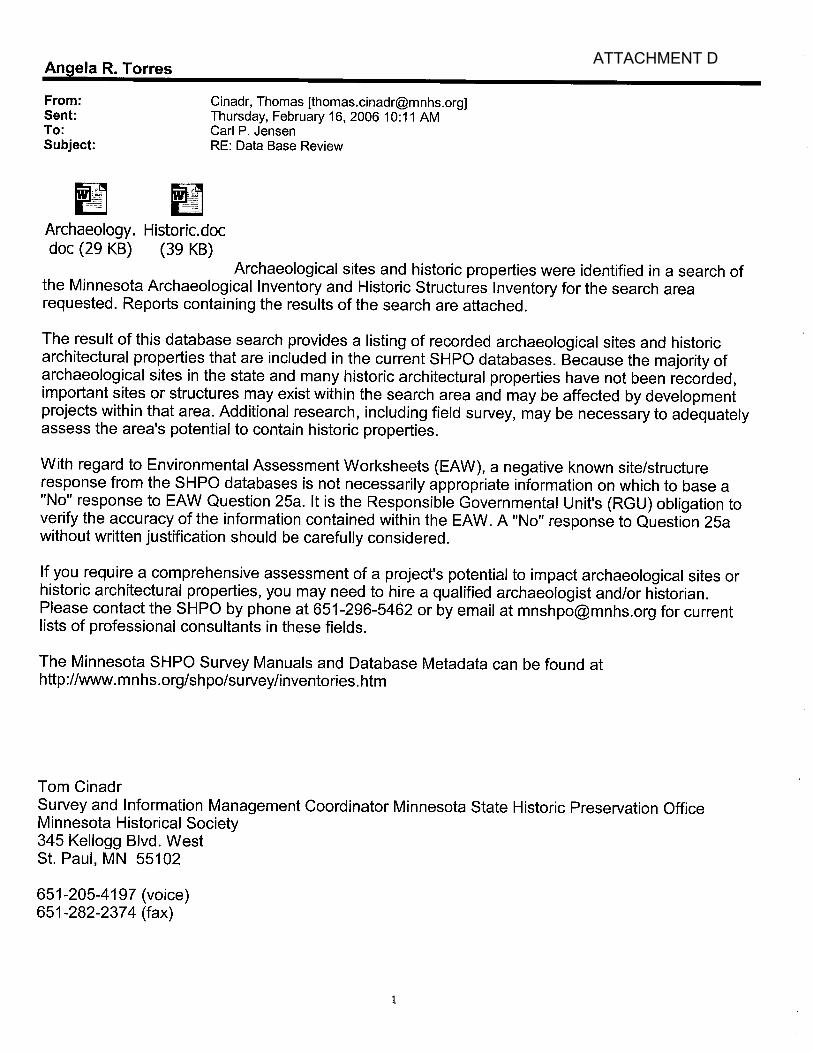
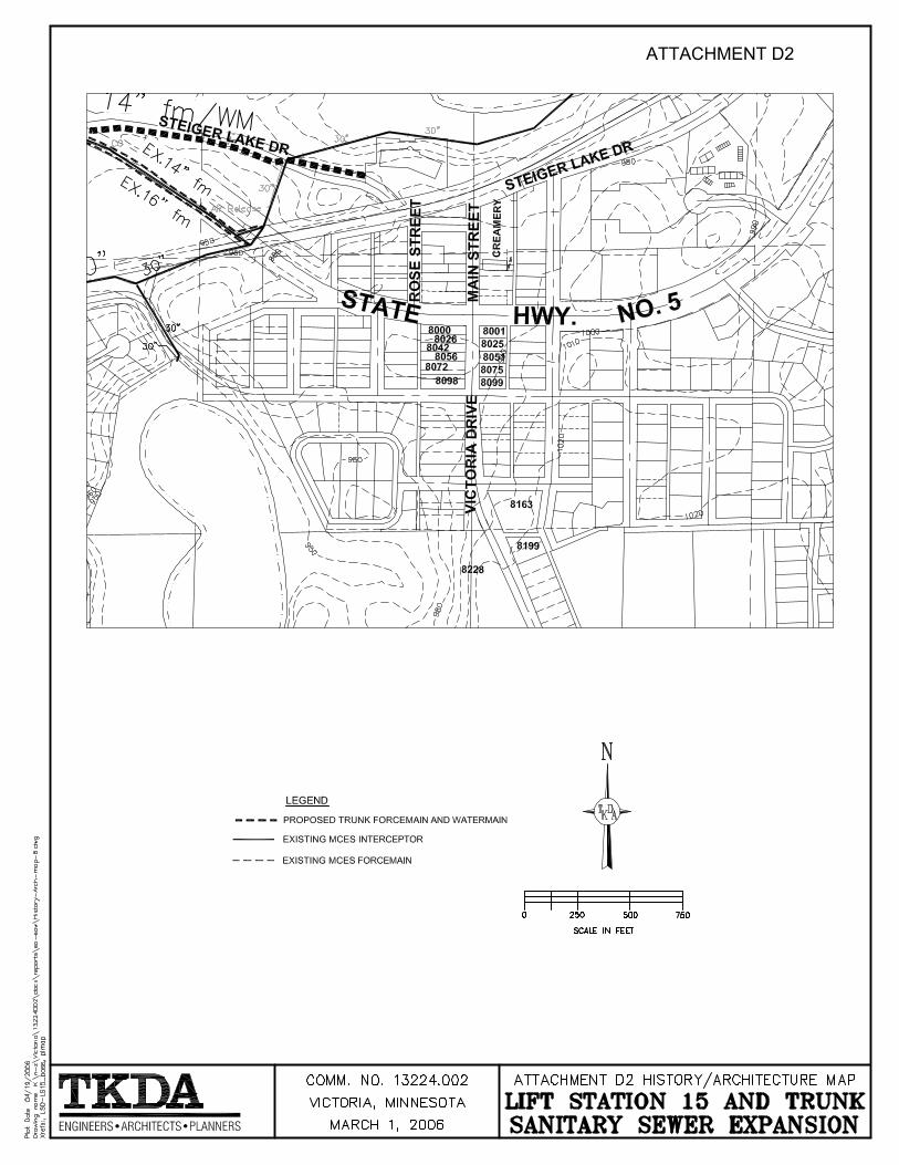
measures to minimize or avoid adverse impacts. Archaeological. A cultural review of the immediate area and surrounding sections was complete by the SHPO, which is part of the Minnesota Historical Society. The SHPO findings (Attachment D) indicate that a number of archaeological sites are located in the surrounding sections and one in the area of the proposed project. That site is generally located in the Northwest quarter section of Township 116, Range 24 West, Section 14. For clarification, Tom Cinadr of the SHPO was contacted for more detail. His review of the specific site number revealed that the site is an abandoned town that was referenced in a historic account. The area of the project located in Section 14 will be located in rights of way along existing roads and will not impact this site. History/Architecture. The SHPO findings (Attachment D) indicate that a number of historical or architectural sites are also located in the surrounding sections and eleven in the sections where the project will be physically located. Three of the sites did not have addresses listed, so Mr. Cinadr of the SHPO was contacted for clarification. He reviewed the sites and all had an address of xxx Main Street. All but one of these sites was located well away from the project area, near downtown Victoria. The Reitz farmhouse is on the property located just to the west of the proposed project as shown in Attachment D, and will not be disturbed by the project. Designated parks. The proposed project corridor is located next to Carver County Park Reserve. The park is used for recreational activities utilizing its wetlands, walking trails, sledding facilities and other general activities, none of which occur or are located near the utility alignment.
26. Visual impacts. Will the project create adverse visual impacts during construction or operation? Such as glare from intense lights, lights visible in wilderness areas and large visible plumes from cooling towers or exhaust stacks? Yes No If yes, explain.
27. Compatibility with plans and land use regulations. Is the project subject to an adopted local comprehensive plan, land use plan or regulation, or other applicable land use, water, or resource management plan of a local, regional, state or federal agency? Yes No
If yes, describe the plan, discuss its compatibility with the project and explain how any conflicts will be resolved. If no, explain. The proposed trunk sanitary main and trunk watermain have been planned and are included in the City’s Comprehensive Plan.
Victoria Interceptor and Lift Station 15 Environmental Assessment Victoria, Minnesota 15 Worksheet
28. Impact on infrastructure and public services. Will new or expanded utilities, roads, other infrastructure
or public services be required to serve the project? Yes No If yes, describe the new or additional infrastructure or services needed. (Note: any infrastructure that is a connected action with respect to the project must be assessed in the EAW; see EAW Guidelines for details.) Ultimately, the 21-inch sanitary sewer will provide peak flows of 3.5 MGD and average daily flows of 1.1 MGD of wastewater from proposed or future residential neighborhoods that will be transported to the MCES collector system. The ultimate flows from this project will create an additional need for improvements to the Metropolitan Council interceptor facilities. The Metropolitan Council is aware of these needs and is in the planning stages of upgrading and increasing the capacity of their interceptor system. Construction of these improvements is expected to being in 2007. Any future development of the west/southwest area of the City beyond the Krey Lakes Development is limited to the current capacity of the collector system until the MCES improvements are complete and on line.
29. Cumulative impacts. Minn. R. 4410.1700, subp. 7, item B requires that the RGU consider the “cumulative potential effects of related or anticipated future projects” when determining the need for an environmental impact statement. Identify any past, present or reasonably foreseeable future projects that may interact with the project described in this EAW in such a way as to cause cumulative impacts. Describe the nature of the cumulative impacts and summarize any other available information relevant to determining whether there is potential for significant environmental effects due to cumulative impacts (or discuss each cumulative impact under appropriate item(s) elsewhere on this form). The proposed project is providing trunk sanitary and watermain services to a recently-annexed area of the City that previously was not served. The area will begin to be developed immediately with the residential neighborhood. As per the City’s Comprehensive Plan, these residential areas are planned as 80 percent low density, 15 percent medium density and 5 percent high density. The flows for the currently planned development (Krey Lakes Development) can be accommodated by the current MCES collector system. However, as discussed in Item 18, the capacity of the sewer line that is part of this project will allow ultimate flows that will exceed the current capacity of the MCES collector system. The collector system is currently in design for expansion, with construction beginning in 2007. Expansion of the MCES collector system will allow for further development of the west/southwest area of the City, utilizing the 21-inch line discussed in this EAW. The future development enabled by the construction of this project could create secondary impacts to wetlands, stormwater runoff and receiving waters, wildlife, and traffic. Some of these projects may be subject to environmental review depending on their scope. These will be reviewed at the time of the proposals and mitigation measures, if necessary, will be identified. In addition to the environmental review process, new development will be required to obtain permits and approvals that will help control potential impacts. These include NPDES Permit, Wetland Conservation Act permitting, and approvals in accordance with the City’s Comprehensive Plan.
30. Other Potential Environmental Impacts. If the project may cause any adverse environmental impacts not addressed by items 1 to 28, identify and discuss them here, along with any proposed mitigation. No other adverse environmental impacts other than those noted previously are anticipated as a result of this project.


ATTACHMENT A


ATTACHMENT B


ATTACHMENT C


ATTACHMENT D

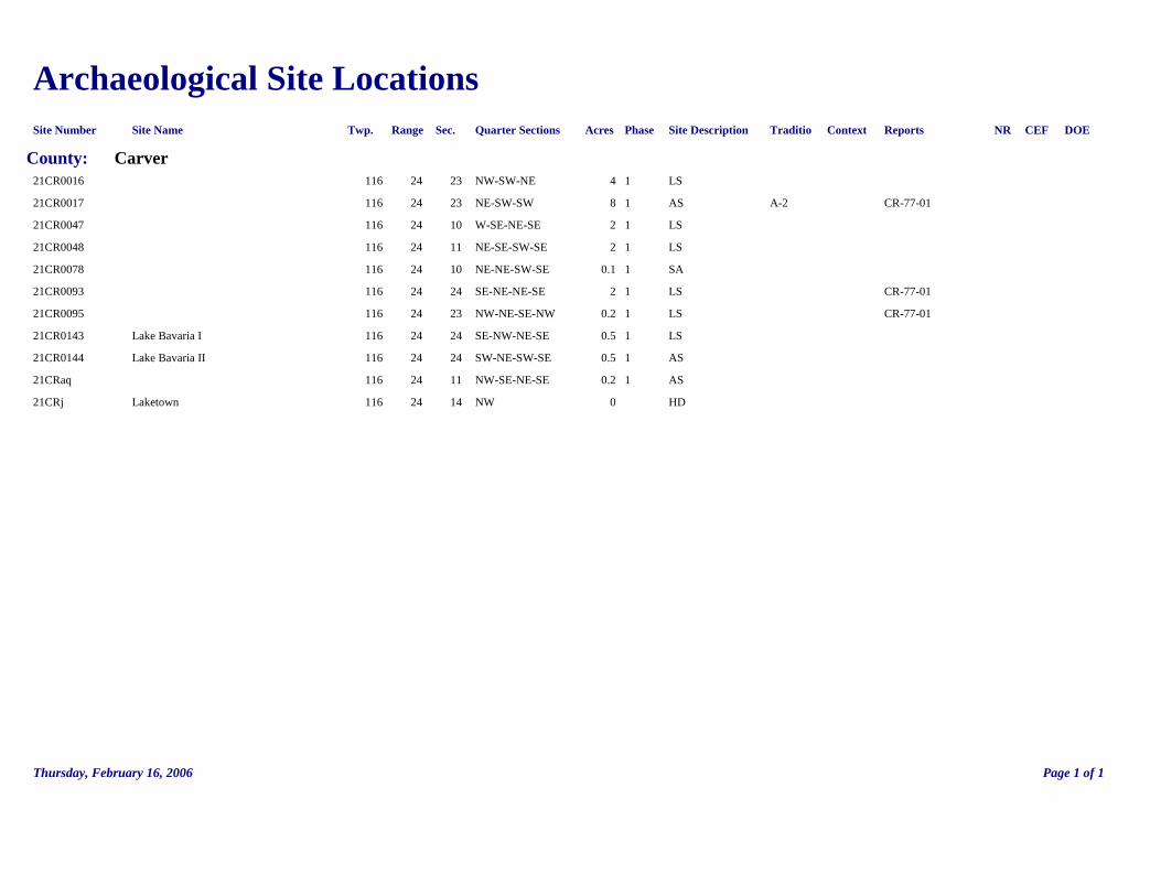
Archaeological Site Locations Site Number Site Name Twp. Range Sec. Quarter Sections Acres Phase Site Description Traditio Context Reports NR CEF DOE
County: Carver 21CR0016 116 24 23 NW-SW-NE 4 1 LS 21CR0017 116 24 23 NE-SW-SW 8 1 AS A-2 CR-77-01 21CR0047 116 24 10 W-SE-NE-SE 2 1 LS 21CR0048 116 24 11 NE-SE-SW-SE 2 1 LS 21CR0078 116 24 10 NE-NE-SW-SE 0.1 1 SA 21CR0093 116 24 24 SE-NE-NE-SE 2 1 LS CR-77-01 21CR0095 116 24 23 NW-NE-SE-NW 0.2 1 LS CR-77-01 21CR0143 Lake Bavaria I 116 24 24 SE-NW-NE-SE 0.5 1 LS 21CR0144 Lake Bavaria II 116 24 24 SW-NE-SW-SE 0.5 1 AS 21CRaq 116 24 11 NW-SE-NE-SE 0.2 1 AS 21CRj Laketown 116 24 14 NW 0 HD
Thursday, February 16, 2006 Page 1 of 1

History/Architecture PROPERTY NAME ADDRESS Twp Range Sec Quarters USGS Report NRHP CEF DOE Inventory Number
COUNTY Carver CITY/TOWNSHIP: Laketown Twp. Henry Gerdsen Farmstead off Co. Hwy. 11 116 24 10 NE-SW-NW Victoria CR-78-1H CR-LKT-003 Laketown Moravian Brethren's Church 116 24 11 NW-NE-SW Victoria CR-78-1H Y CR-LKT-004 Michael Diethelm House 116 24 24 NE-SW-SW Victoria CR-78-1H CR-LKT-005 Rietz Farmhouse 6785 Co. Hwy. 5 116 24 15 SE-NE-NW Victoria CR-LKT-009
CITY/TOWNSHIP: Victoria house 8661 Victoria Dr. 116 24 24 NE-NW-NW Victoria CR-94-2H CR-LKT-011 feed mill off Mn. Hwy. 113 116 24 13 SW-NW-NW Victoria CR-77-1H CR-VTC-001 creamery xxx Main St. 116 24 13 NW-SW-NW Victoria CR-77-1H CR-VTC-002 Lynane's Store 116 24 14 NE-SE-NE Victoria CR-77-1H CR-VTC-003 Charles Diethelm House 116 24 14 NE-SE-NE Victoria CR-77-1H CR-VTC-004 Victoria State Bank 116 24 14 NE-SE-NE Victoria CR-77-1H CR-VTC-005 Victoria Catholic Church 8228 Victoria Dr. 116 24 13 NW-NW-SE Victoria CR-77-1H CR-VTC-006 House 8000 Victoria Drive 116 24 14 NE-SE-NE Victoria CR-94-2H CR-VTC-007 House 8001 Victoria Drive 116 24 13 SE-NW-NW Victoria CR-94-2H CR-VTC-008 house 8025 Victoria Dr. 116 24 13 SE-NW-NW Victoria CR-94-2H CR-VTC-009 house 8026 Victoria Dr. 116 24 14 NE-SE-NE Victoria CR-94-2H CR-VTC-010 house 8042 Victoria Dr. 116 24 14 NE-SE-NE Victoria CR-94-2H CR-VTC-011 house 8051 Victoria Dr. 116 24 13 NW-SW-NW Victoria CR-94-2H CR-VTC-012 house 8056 Victoria Dr. 116 24 14 NE-SE-NE Victoria CR-94-2H CR-VTC-013 house 8072 Victoria Dr. 116 24 14 SE-SE-NE Victoria CR-94-2H CR-VTC-014 house 8075 Victoria Dr. 116 24 13 NW-SW-NW Victoria CR-94-2H CR-VTC-015
Thursday, February 16, 2006 Page 1 of 2

PROPERTY NAME ADDRESS Twp Range Sec Quarters USGS Report NRHP CEF DOE Inventory Number
COUNTY Carver CITY/TOWNSHIP: Victoria house 8097 Victoria Dr. 116 24 13 NW-SW-NW Victoria CR-94-2H CR-VTC-016 house 8098 Victoria Dr. 116 24 14 SE-SE-NE Victoria CR-94-2H CR-VTC-017 house 8163 Victoria Dr. 116 24 13 SW-SW-NW Victoria CR-94-2H CR-VTC-018 house 8199 Victoria Dr. 116 24 13 SW-SW-NW Victoria CR-94-2H CR-VTC-019 house 8314 Victoria Dr. 116 24 13 NW-NW-SW Victoria CR-94-2H CR-VTC-020 house 8356 Victoria Dr. 116 24 13 SW-NW-SW Victoria CR-94-2H CR-VTC-021 house 8374 Victoria Dr. 116 24 13 SW-NW-SW Victoria CR-94-2H CR-VTC-022 house 8400 Victoria Dr. 116 24 13 SW-NW-SW Victoria CR-94-2H CR-VTC-023 school 116 24 13 SW-NW-SW Victoria CR-94-2H CR-VTC-024 Bridge No. 505 (razed) Steiger Lake Lane over graveled 116 24 14 SE-NE-NE Victoria Y CR-VTC-025 pedestrial/bike trail
Thursday, February 16, 2006 Page 2 of 2

ATTACHMENT D1
ATTACHMENT D2

Minnesota=s Federally-listed Threatened, Endangered, Proposed, and Candidate
Species= County Distribution For more information about these species in Minnesota, please contact
the U.S. Fish & Wildlife Service office at 4101 E. 80th Street, Bloomington, Minnesota 55425-1665 (612/725-3548)
SPECIES
STATUS
COUNTY
HABITAT
Mammals
Canada lynx (Lynx canadensis)
Threatened
Aitkin, Beltrami, Carlton, Cass, Clearwater, Cook, Itasca, Koochiching, Lake, Lake of The Woods, Marshall, Pine Roseau, St. Louis
Northern forested areas
Gray Wolf (Canis lupus)
Threatened
Aitkin, Becker, Beltrami, Benton, Carlton, Cass, Chisago, Clearwater, Cook, Crow Wing, Hubbard, Isanti, Itasca, Kanabec, Kittson, Koochiching, Lake, Lake of the Woods, Mahnomen, Marshall, Mille Lacs, Morrison, Ottertail, Pennington, Pine, Polk, Red Lake, Roseau, St. Louis, Sherburne, Todd, Wadena
Northern forested areas
Gray Wolf (Canis lupus)
Critical Habitat
Areas of land, water, and airspace in Beltrami, Cook, Itasca, Koochiching, Lake, Lake of the Woods, Roseau, and St. Louis Counties, with boundaries (4th and 5th Principal meridians) identical to those of zones 1, 2, and 3, as delineated in 50 CFR 17.40(d)(1). Please contact FWS at (612)725-3548 for more information.
Birds
Bald eagle (Haliaeetus leucocephalus)
Threatened
Aitkin, Anoka, Becker, Beltrami, Benton, Blue Earth, Brown, Carlton, Carver, Cass, Chippewa, Chisago, Clearwater, Cook, Crow Wing, Dakota, Douglas, Fillmore, Goodhue, Grant, Hennepin, Houston, Hubbard, Isanti, Itasca, Kanabec, Kandiyohi, Kittson, Koochiching, Lac Qui Parle, Lake, Lake of The Woods, Le Sueur, Mahnomen, Marshall, Meeker, Mille Lacs, Morrison, Nicollet, Olmsted, Otter Tail, Pennington, Pine, Polk, Pope, Ramsey, (Continued on Next Page)
Mature forest near water
ATTACHMENT E

SPECIES
STATUS
COUNTY
HABITAT
Bald eagle (Haliaeetus leucocephalus)
Threatened
(Continued From Previous Page) Redwood, Renville, Roseau, Scott, Sherburne, Sibley, St. Louis, Stearns, Swift, Todd, Wabasha, Wadena, Waseca, Washington, Winona, Wright, Yellow Medicine
Piping Plover (Charadrius melodus) Northern Great Plains Breeding Population
Threatened
Lake of the Woods
sandy beaches, islands
Piping Plover (Charadrius melodus) Great Lakes Breeding Population
Critical Habitat Designated
St. Louis
sandy beaches
Piping Plover (Charadrius melodus) Northern Great Plains Breeding Population
Critical Habitat
Lake of the Woods
sandy beaches
Reptiles
Eastern massasauga (Sistrurus catenatus catenatus)
Candidate
Houston, Wabasha, Winona
Floodplain wetlands and nearby upland areas along the Mississippi River and Tributaries
Fish
Topeka shiner (Notropis topeka)
Endangered
Lincoln, Murray, Nobles, Pipestone, Rock
Prairie rivers and streams
Topeka shiner (Notropis topeka)
Critical Habitat
Lincoln, Murray, Nobles, Pipestone, Rock
Mussels
Higgins eye pearlymussel (Lampsilis higginsii)
Endangered
Chisago, Dakota, Goodhue, Hennepin, Houston, Ramsey, Wabasha, Washington, Winona
Mississippi and St. Croix Rivers
Sheepnose Mussel (Plethobasus cyphyus)
Candidate Wabasha, Washington, Winona Mississippi River in Wabasha and Winona counties, St. Croix River in Washington county
Spectaclecase (Cumberlandia monodonta)
Candidate Chisago, Pine, Washington St. Croix River and Rush Creek
Winged mapleleaf mussel (Quadrula fragosa)
Endangered
Chisago, Washington
St. Croix River
Insects
Dakota skipper (Hesperia dacotae)
Candidate
Big Stone, Chippewa, Clay, Cottonwood, Kittson, Lac Qui Parle, Lincoln, Murray, Norman, Pipestone, Polk, Pope, Swift, Traverse, Yellow Medicine
Native prairie habitat

SPECIES
STATUS
COUNTY
HABITAT
Karner blue butterfly (Lycaeides melissa samuelis)
Endangered
Winona
Pine barrens and oak savannas on sandy soils and containing wild lupines (Lupinus perennis), the only known food plant of larvae.
Plants
Dwarf trout lily (Erythronium propullans)
Endangered
Dakota, Goodhue, Rice, Steele
North facing slopes and floodplains in deciduous forest
Leedy=s roseroot (Sedum integrifolium ssp. leedyi)
Threatened
Fillmore, Olmsted
Cool, wet groundwater-fed limestone cliffs
Prairie bush-clover (Lespedeza leptostachya)
Threatened
Brown, Cottonwood, Dakota, Dodge, Goodhue, Houston, Jackson, Martin, Mower, Olmsted, Redwood, Renville, Rice
Gravelly soil in dry to mesic prairies
Western prairie fringed orchid (Platanthera praeclara)
Threatened
Clay, Dodge, Kittson, Lincoln, Mower, Nobles, Norman, Pennington, Pipestone, Polk, Red Lake, Rock
Wet prairies and sedge meadows
Revised October 2005


44-50-40 N
44-5
0-40
N
44-51-20 N
44-5
1-20
N
44-51-0 N
44-5
1-0
N
44-52-0 N
44-5
2-0
N
44-52-20 N
44-5
2-20
N
44-51-40 N
44-5
1-40
N
93-41-30 W
93-41-30 W
93-41-0 W
93-41-0 W
93-40-0 W
93-40-0 W
93-39-30 W
93-39-30 W
93-40-30 W
93-40-30 W
NATIONAL WETLANDS INVENTORY
Legend
This map is a user generated static output from an Internet mapping site and is for generalreference only. Data layers that appear on this map may or may not be accurate, current, orotherwise reliable. THIS MAP IS NOT TO BE USED FOR NAVIGATION.
Notes: CITY OF VICTORIA MINNESOTAOVERALL
Scale: 1:30,000Map center: 44° 51' 31" N, 93° 40' 34" W

44-51-20 N
44-5
1-20
N
44-51-50 N
44-5
1-50
N
44-51-10 N
44-5
1-10
N
44-51-30 N
44-5
1-30
N
44-51-40 N
44-5
1-40
N
93-41-20 W
93-41-20 W
93-41-0 W
93-41-0 W
93-40-40 W
93-40-40 W
NATIONAL WETLAND INVENTORY
Legend
This map is a user generated static output from an Internet mapping site and is for generalreference only. Data layers that appear on this map may or may not be accurate, current, orotherwise reliable. THIS MAP IS NOT TO BE USED FOR NAVIGATION.
Notes: CITY OF VICTORIA MINNESOTAMAP 1
Scale: 1:15,000Map center: 44° 51' 30" N, 93° 41' 4" W
44-51-20 N
44-5
1-20
N
44-51-50 N
44-5
1-50
N
44-51-10 N
44-5
1-10
N
44-51-30 N
44-5
1-30
N
44-51-40 N
44-5
1-40
N
93-40-0 W
93-40-0 W
93-40-40 W
93-40-40 W
93-40-20 W
93-40-20 W
NATIONAL WETLANDS INVENTORY
Legend
This map is a user generated static output from an Internet mapping site and is for generalreference only. Data layers that appear on this map may or may not be accurate, current, orotherwise reliable. THIS MAP IS NOT TO BE USED FOR NAVIGATION.
Notes: CITY OF VICTORIA MINNESOTAMAP 2
Scale: 1:15,000Map center: 44° 51' 31" N, 93° 40' 15" W


![THE GREAT DIVIDE - University Of Illinois · ACT I] THE GREAT DIVIDE 5 PHILIP. Gruffly', as he rises. Give me a lift with the trunk, Win. They carry the trunk outside, Polly\ with](https://static.documents.pub/doc/80x56/5f640b441c7d955b095d78e0/the-great-divide-university-of-illinois-act-i-the-great-divide-5-philip-gruffly.jpg)


