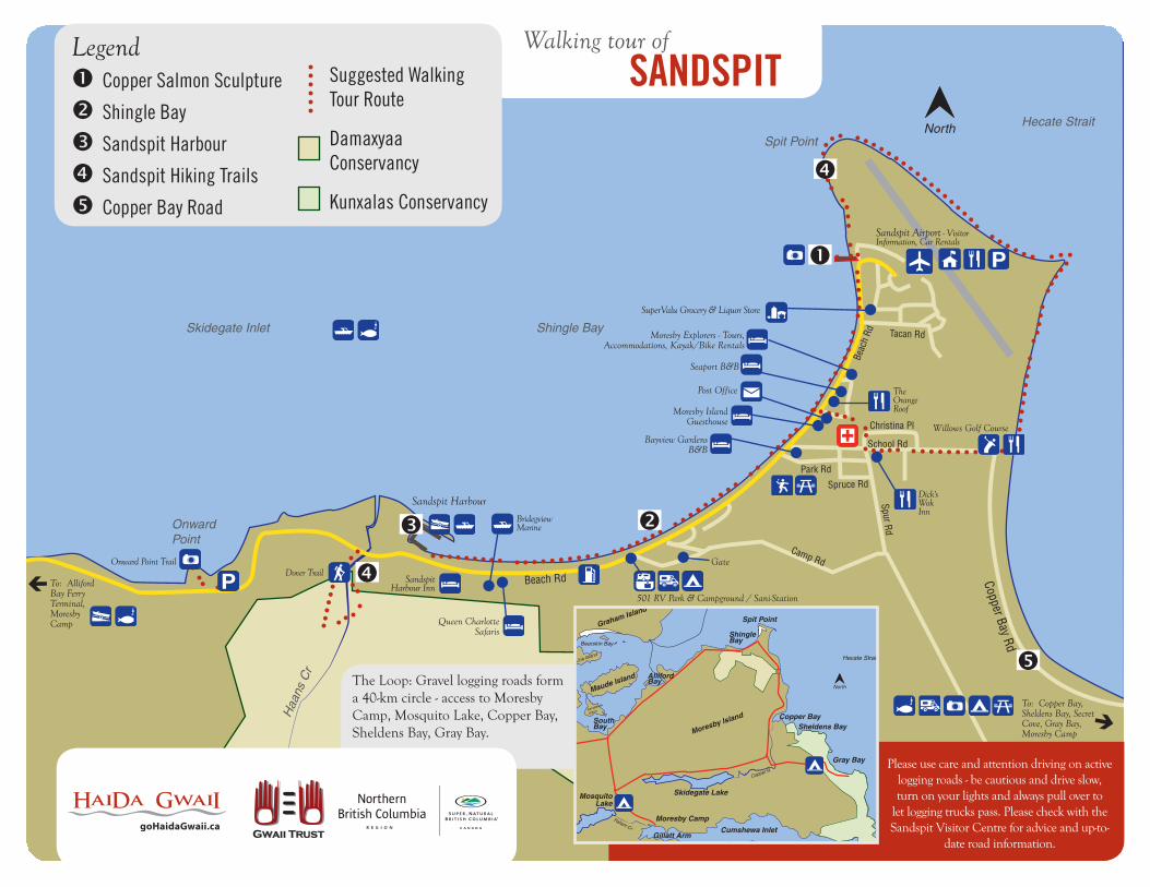
Copper Bay Rd School Rd Hecate Strait Spit Point North Onward Point Park Rd Beach Rd Shingle Bay Haans Cr Christina Pl Tacan Rd Beach Rd Camp Rd Spruce Rd Spur Rd Skidegate Inlet Walking tour of SANDSPIT Legend Copper Salmon Sculpture Suggested Walking Tour Route Shingle Bay Sandspit Harbour Damaxyaa Conservancy Sandspit Hiking Trails Copper Bay Road Kunxalas Conservancy Willows Golf Course To: Alliford Bay Ferry Terminal, Moresby Camp Queen Charlotte Safaris Please use care and attention driving on active logging roads - be cautious and drive slow, turn on your lights and always pull over to let logging trucks pass. Please check with the Sandspit Visitor Centre for advice and up-to- date road information. Bayview Gardens B&B The Orange Roof Sandspit Harbour Inn Moresby Explorers - Tours, Accommodations, Kayak/Bike Rentals Sandspit Airport - Visitor Information, Car Rentals Dick's Wok Inn To: Copper Bay, Sheldens Bay, Secret Cove, Gray Bay, Moresby Camp SuperValu Grocery & Liquor Store Moresby Island Guesthouse The Loop: Gravel logging roads form a 40-km circle - access to Moresby Camp, Mosquito Lake, Copper Bay, Sheldens Bay, Gray Bay. Sandspit Harbour Dover Trail Onward Point Trail Seaport B&B Post Office Bridegview Marine Gate 501 RV Park & Campground / Sani-Station Hecate Strait Skidegate Lake Mosquito Lake Shingle Bay Copper Bay Cumshewa Inlet Gillatt Arm Pallant Cr Copper R Sheldens Bay Gray Bay South Bay Spit Point Bearskin Bay North Maude Island Sandilands Island Lina Island Moresby Island Graham Island Alliford Bay Moresby Camp
Sandspit Airport - Visitor Information, Car Rentals
Dick's Wok Inn
To: Copper Bay, Sheldens Bay, Secret Cove, Gray Bay, Moresby Camp
SuperValu Grocery & Liquor Store
Moresby Island Guesthouse
The Loop: Gravel logging roads form a 40-km circle - access to Moresby Camp, Mosquito Lake, Copper Bay, Sheldens Bay, Gray Bay.
Sandspit Harbour
Dover TrailOnward Point Trail
Seaport B&B
Post Office
Bridegview Marine
Gate
501 RV Park & Campground / Sani-Station
Hecate Strait
Skidegate LakeMosquitoLake
Shingle Bay
Copper Bay
Cumshewa InletGillatt Arm
Pallant Cr
Copper R
Sheldens Bay
Gray Bay
South Bay
Spit Point
Bearskin Bay
NorthMaude Island
Sandilands
Island
Lina Island
Moresby Island
Graham Island
Graham Island
Alliford Bay
Moresby Camp
Sandspit is a small hamlet situated on the northeast tip of Moresby Island, 14 km (9 mi) east of Alliford Bay. Sandspit has a lengthy history which dates back to at least one ancient Haida village, Kil. The flat grassy land in the area was ideal for the farms and ranches established by Sandspit's first pioneer settlers. Sandspit's first major industry in 1910 was a dogfish oilery, followed by a fish cannery in 1913. Today, the main industries are transportation, logging and tourism. Sandspit is the starting point for those wanting to visit the Gwaii Haanas National Park Reserve and Haida Heritage Site and Marine Protected Area Reserve, but departure is by air or water, since there are no roads to Gwaii Haanas. Plenty of outdoor recreational opportunities are available in Sandspit and the surrounding area. There are several hiking trails nearby. Sandspit is a hotbed for fishing especially during the late Coho runs in September and October, and also offers wonderful camping opportunities. Birding and kayaking are also popular activities in the area.
Copper Salmon SculptureBuilt from copper and cedar in 2002 by local artist Lon Sharpe. The sculpture embraces the spirit of the community.
Shingle BayShingle Bay provides a beautiful view of the inlet and mountains. Beach comb and check out the wildlife as you stroll along the bay. The route around the tip of the sand spit that gives the town its name is a wide flat grassy trail that follows the fence around the airport and/or can be followed along the beach. This is one of the best areas on Haida Gwaii for bird watching and is a catch basin for rare migratory birds especially during May and June. November through May is a good time to spot loons and Brant geese. Throughout the spring and summer you may spot eagles, sandpipers, Black Oystercatchers, Killdeer, plover, Greater White Fronted Geese, Ruddy Turnstone, Pigeon Guillemot, Great Blue Heron, Peregrine Falcon, Ring-Neck Dove/Turtle Dove, Sandhill Crane and Northern Harrier Hawk. Keep an eye out on bushes and trees where you may spot Cedar Waxwings, warblers, sparrows, Short Eared Owls and Robins.
Sandspit HarbourThe gateway marina to the Gwaii Haanas National Park Reserve and Haida Heritage Site is a state-of-the-art facility. Eighty-four slips are available for permanent and transient moorage, accommodating vessels up to 114' in length. Regular gas, premium gas and diesel are dispensed at the fuel dock; potable water, dock side electricity (15, 30, 50, 100 amps), 2.5 ton lift, storage yard, seaplane float, Restrooms, showers, garbage bins, waste pump-out, public phone and launching ramp are all located in this quiet, well-protected harbour. Reservations for the busy summer season are strongly recommended. (www.sandspitharbour.com/index.php)
Sandspit TrailsRemember that the weather changes quickly here, and you should always be prepared for rain. Trails can be slippery and muddy due to the damp climate. Look for more information at the Visitor Centre.
Onward Point - The 10-15 minute walk around the Onward Point trail is favourite with Sandspit families. The looped trail leads from a parking lot on the road between Alliford Bay and Sandspit out onto a rocky point with a gazebo. This is the best area to look for Gray Whales in the spring, as they like to feed just off this point. The trail winds through picturesque forest, and is easy to follow.
Dover Trail - Named after Louise Dover, a Haida woman who lived most of her life in Sandspit. The trail head for this hike is on the west end of Sandspit, very close to the marina. There is a small paved pull-out for parking just west of the Haans Creek bridge, and the first section of the trail follows the flat valley bottom along the creek. The trail then climbs into a 5 km loop, which will take 1 to 1.5 hours
Welcome toSANDSPIT
www.sandspitbc.ca
Gateway to Gwaii Haanas
Police • 250-559-4421Ambulance • 1-888-461-9911Volunteer Fire Department • 250-637-2222Sandspit Health Clinic • 250-637-5403Coast Guard • 1-800-567-5111
to complete. Sections of this trail are steep and muddy, and there are sometimes fallen branches or even trees across the trail. The highlights of this trail are the pristine old-growth forest and the rich plant life along the banks of Haans Creek, where salmon spawn in the fall. The Dover Trail is within the Damaxyaa (pronunciation: Daamaachia) Conservancy (www.env.gov.bc.ca/bcparks/explore/cnsrvncy/damaxyaa)
The Spit - The route around the tip of the sand spit that gives the town its name is probably the most popular trail with locals, since it is within an easy walk of most homes in Sandspit. This wide, flat, grassy trail follows the outside of the fence around the airport, or you can walk on the beach. Walking all the way around the spit takes about 1 hour, but leave some time for beachcombing as well. This is also one of the best areas on the islands for bird watching.
Copper Bay Road/Moresby LoopThe logging roads from Sandspit lead to the campsites of Gray Bay and Mosquito Lake (a popular swimming and fishing spot). Logging roads also lead to Moresby Camp, a popular campground and the most southern road access on the islands, used extensively by operators providing tours and transportation into Gwaii Haanas.
Secret Cove Trail - An easy 10 minute forested wilderness trail that leads to the secluded pebble beach at Secret Cove.
Gray Bay – A beautiful crescent shaped 4 km gray sand beach and campground set amidst forests of alder, giant spruce and hemlock. Gray Bay is also the starting point to the Secret Cove Trail and the Cumshewa Head Trail .
Mount Moresby – The hiking route up Mount Moresby leads from close to sea level to the highest point on Haida Gwaii at 1164 m. This is a steep and difficult trail that can be completed in one long day or as an overnight trip.
Mosquito Lake – A picturesque lake with great trout fishing that offers several campsites, a boat launch and a small sheltered picnic area. Mosquito Lake is named after the Second World War Mosquito fighter-bombers, not after the insect.


![HAIDA LAND USE VISION - Council of the Haida Nation · Haida Gwaii Yah’guudang — respecting Haida Gwaii HAIDA GWAII YAH’GUUDANG [ respecting Haida Gwaii ] HAIDA LAND USE VISION](https://static.documents.pub/doc/80x56/5ae04c117f8b9a5a668d5ef6/haida-land-use-vision-council-of-the-haida-gwaii-yahguudang-respecting.jpg)

