VIM. Water Resources D. B. SimonP Remote-sensing techniques can be extremely useful for all aspects of watershed analysis. For example, they have been used for determining runoff from watersheds, for estimating flood hazards, and for performing flood zone studies. In addition, such studies are extremely valuable in connection with identification and analysis of droughts. Soil moisture, which relates to runoff from the watershed, can be mapped. Ground water can be considered, and methods of improving ground-water storage as well as of identifying ground-water reservoirs represent possible uses of remotely sensed information. The interrelationship of all these many factors helps water resource researchers to obtain common, useful answers. Studies in water resources management and development have involved most regions of the United States and several foreign countries. The results of such studies can be incorporated into models that lead to planning, decisionmakfng, and ultimate development. This summary is subdivided into broad headings, arranged in an order intended to assist the reader in obtaining a better, more meaningful overview of the contributions that have been made, the areas of research that should be pursued, and probable long-term benefits that can be realized by undertaking continued activities of these types. GEOLOGY AND HYDROGEOLOGY Skylab and Landsat data are excellent for the identification of major watershed features, such as large-scale rock formations, drainage networks, major faults, and vegetated areas. However, because of the vast area visible by this means, remote sensing from space platforms cannot give the detailed information that may be of interest within a watershed. Aircraft-flown sensors are needed for classification of details where much greater resolution is required. By this means, data can be gathered at a scale chosen to obtain the desired detail for studies of particular small areas or points of interest. ANALYSIS OF WATERSHEDS Water resources represent one of the most valuable assets of any nation. To understand, to appreciate, and to properly use water resources, one must understand the overall complexities of watersheds and river systems. Figure VIII-1 illustrates the complexity and area of a major river system. The Mississippi River watershed, like that of any size river, is both complex and dynamic. In fact, rivers are the most rapidly changing of all geomorphic forms. One can clearly identify and study stream networks and their characteristics using data from Skylab, Landsat, and aircraft sensors (W-8, vol. I-D). All sources of data are useful, and the ultimate value of remotely sensed data depends on the problem being studied. For an overview of the watershed and for the determination of some of its major features, Skylab or Landsat data are indispensable. Conversely, for studying in detail a short reach of river, riverbanks, or a remote watershed, aircraft data become more valuable because one can concentrate on a small area and obtain sufficiently detailed data to analyze even the m6st minute aspects of the watershed. As a result of recent studies of watersheds and their characteristics, techniques have been developed that enable more accurate identification of impervious parts of the watershed, whether they are impervious as a consequence of natural formations or as a consequence of man's development of the surfaces. This capability to sense the imperviousness of a surface is an advance that will improve man's ability to assess the effects of such surface areas on the magnitude of runoff, the time of concentration, the time of peaking, and so forth. SNOW AND ICE In considering water resources, snow cover is an integral and important part of the hydrologic scene. Either directly or indirectly, snow cover affects most of Colorado State University- Fort Collins, Colorado. 41
Transcript
VIM. Water ResourcesD. B. SimonP
Remote-sensing techniques can be extremely usefulfor all aspects of watershed analysis. For example, theyhave been used for determining runoff from watersheds,for estimating flood hazards, and for performing floodzone studies. In addition, such studies are extremelyvaluable in connection with identification and analysisof droughts. Soil moisture, which relates to runoff fromthe watershed, can be mapped. Ground water can beconsidered, and methods of improving ground-waterstorage as well as of identifying ground-water reservoirsrepresent possible uses of remotely sensed information.The interrelationship of all these many factors helpswater resource researchers to obtain common, usefulanswers. Studies in water resources management anddevelopment have involved most regions of the UnitedStates and several foreign countries. The results of suchstudies can be incorporated into models that lead toplanning, decisionmakfng, and ultimate development.
This summary is subdivided into broad headings,arranged in an order intended to assist the reader inobtaining a better, more meaningful overview of thecontributions that have been made, the areas of researchthat should be pursued, and probable long-term benefitsthat can be realized by undertaking continued activitiesof these types.
GEOLOGY AND HYDROGEOLOGY
Skylab and Landsat data are excellent for theidentification of major watershed features, such aslarge-scale rock formations, drainage networks, majorfaults, and vegetated areas. However, because of the vastarea visible by this means, remote sensing from spaceplatforms cannot give the detailed information that maybe of interest within a watershed. Aircraft-flown sensorsare needed for classification of details where muchgreater resolution is required. By this means, data can begathered at a scale chosen to obtain the desired detail forstudies of particular small areas or points of interest.
ANALYSIS OF WATERSHEDS
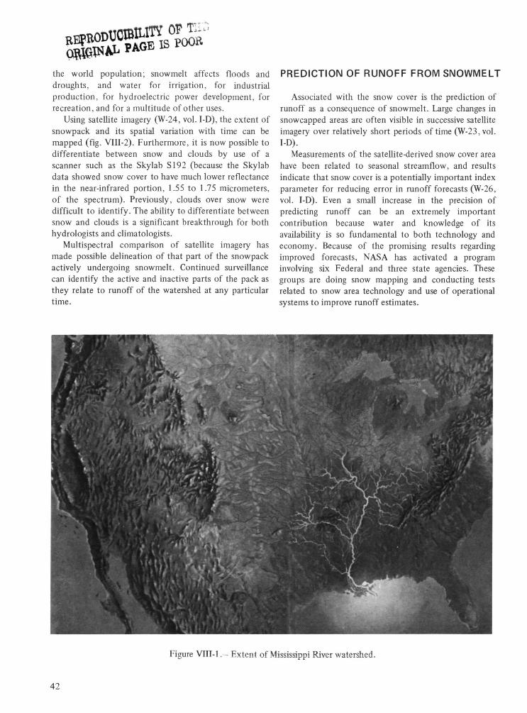
Water resources represent one of the most valuableassets of any nation. To understand, to appreciate, andto properly use water resources, one must understandthe overall complexities of watersheds and river systems.Figure VIII-1 illustrates the complexity and area of amajor river system. The Mississippi River watershed, likethat of any size river, is both complex and dynamic. Infact, rivers are the most rapidly changing of allgeomorphic forms.
One can clearly identify and study stream networksand their characteristics using data from Skylab,Landsat, and aircraft sensors (W-8, vol. I-D). All sourcesof data are useful, and the ultimate value of remotelysensed data depends on the problem being studied. Foran overview of the watershed and for the determinationof some of its major features, Skylab or Landsat data areindispensable. Conversely, for studying in detail a shortreach of river, riverbanks, or a remote watershed, aircraftdata become more valuable because one can concentrateon a small area and obtain sufficiently detailed data toanalyze even the m6st minute aspects of the watershed.
As a result of recent studies of watersheds and theircharacteristics, techniques have been developed thatenable more accurate identification of impervious partsof the watershed, whether they are impervious as aconsequence of natural formations or as a consequenceof man's development of the surfaces. This capability tosense the imperviousness of a surface is an advance thatwill improve man's ability to assess the effects of suchsurface areas on the magnitude of runoff, the time ofconcentration, the time of peaking, and so forth.
SNOW AND ICE
In considering water resources, snow cover is anintegral and important part of the hydrologic scene.Either directly or indirectly, snow cover affects most of
Colorado State University- Fort Collins, Colorado.
41
the world population; snowmelt affects floods anddroughts, and water for irrigation, for industrialproduction, for hydroelectric power development, forrecreation, and for a multitude of other uses.
Using satellite imagery (W-24, vol. I-D), the extent ofsnowpack and its spatial variation with time can bemapped (fig. VIII-2). Furthermore, it is now possible todifferentiate between snow and clouds by use of ascanner such as the Skylab S192 (because the Skylabdata showed snow cover to have much lower reflectancein the near-infrared portion, 1.55 to 1.75 micrometers,of the spectrum). Previously, clouds over snow weredifficult to identify. The ability to differentiate betweensnow and clouds is a significant breakthrough for bothhydrologists and climatologists.
Multispectral comparison of satelh'te imagery hasmade possible delineation of that part of the snowpackactively undergoing snowmelt. Continued surveillancecan identify the active and inactive parts of the pack asthey relate to runoff of the watershed at any particulartime.
PREDICTION OF RUNOFF FROM SNOWMELT
Associated with the snow cover is the prediction ofrunoff as a consequence of snowmelt. Large changes insnowcapped areas are often visible in successive satelliteimagery over relatively short periods of time (W-23, vol.I-D).
Measurements of the satellite-derived snow cover areahave been related to seasonal streamflow, and resultsindicate that snow cover is a potentially important indexparameter for reducing error in runoff forecasts (W-26,vol. 1-D). Even a small increase in the precision ofpredicting runoff can be an extremely importantcontribution because water and knowledge of itsavailability is so fundamental to both technology andeconomy. Because of the promising results regardingimproved forecasts, NASA has activated a programinvolving six Federal and three state agencies. Thesegroups are doing snow mapping and conducting testsrelated to snow area technology and use of operationalsystems to improve runoff estimates.
Figure VIII-1.- Extent of Mississippi River watershed.
42
(a) April 4, 1969: snow-covered area, 60 percent; (b) April 3, 1971: snow-covered area 44 percent;predicted April to June runoff, 29 590 000 predicted April to June runoff, 24 990 000acre-feet. acre-feet.
Figure VIII-2.- Satellite observations of the variation is snow cover at the beginning of snowmelt in the Indus RiverBasin. Imagery is from the Environmental Science Service Administration satellite ESSA-9.
HYDROLOGIC LAND USECLASSIFICATIONS
Hydrologic land use classifications are important toriver watershed management. Multispectral analysis ofsatellite and aircraft data can yield this vital informationregarding the water surface, the agricultural activity andtype of agriculture, urban development, residentialconstruction, forested areas, marsh areas, and so forth inthe watershed (W-13, vol. I-D). Such analysis techniqueshave been applied to satellite and aircraft data to providea broad and detailed information base related toconditions in the flood-prone areas of the watershed.These data have been compared to conventional U.S.Geological Survey (USGS) flood-plain boundary maps,and unflooded regions were shown to exist within theUSGS-identified flood boundaries. An important pointshould be made here. When remotely sensed data areused to study a watershed, an opportunity to look at thetotal watershed is created. Of course, the detail dependson the type of remotely sensed data available.Conversely, when flood-plain boundaries are based onfield reconnaissance and field surveys, time limitationsmay prevent consideration of all conditions adjacent tothe streams. Consequently, the occurrence of unfloodedareas within flood plains may not be detected whenconventional methods are used.
The cost of studying watersheds varies greatlydepending on the details desired. Watershed mapping bysatellite of the type mentioned could be conducted foran approximate cost of $4.30 per square kilometer. Thistechnique enables the mapper to obtain an excellentunderstanding of at least 90 percent of the watershedbeing studied.
Other studies (W-19 and W-22, vol. I-D) indicate thatsignificant financial savings result from using remotelysensed data properly. In one instance, the mosteconomical method of performing a land survey involvedusing U-2 aircraft imagery, although both the satelliteand the U-2 data provided less expensive and moreeffective information than could be obtained usingconventional methods. Remote sensing enables anoverall view to the degree of precision dictated byresolution requirements and budget limitations. Suchinformation helps resolve differences in survey statisticsregarding areas of irrigated land, fallow land, and otherland uses. More precise information of this type assistsgreatly in planning and developing an area.
SOIL MOISTURE
Skylab microwave data, especially from the L-band,have indicated a high correlation between radiometer
43
temperature and soil moisture content near the landsurface (W-6, vol. I-D). Such information is extremelyvaluable to all groups and individuals interested inwatershed utilization and development. For example, inconsidering runoff from watersheds, knowledge of themoisture values at any given time over the totalwatershed would add greatly to the precision with whichstorm runoff and sediment discharge from the watershedcould be estimated for immediate and subsequentstorms.
EVAPOTR ANSPI RATION
When water availability and utilization from and onthe watershed are being considered, knowledge ofevapotranspiration rates is important. More specifically,it is vital to irrigated agriculture and water supply for allusers. Maps estimating evapotranspiration rates from theagricultural landscape have been produced using SkylabS192 data (W-21, vol. I-D). These results were evaluatedusing ground measurements. Such studies can greatlybenefit operational irrigation scheduling managementsystems.
PLAYA LAKES
The many small, shallow playa lakes in the HighPlains of Texas, or similar lakes anywhere, are of greatimportance in the optimum use of water resources.These lakes also may affect the salinity of adjacentlands. In the High Plains of Texas (W-18, vol. I-D),nearly 70 000 irrigation wells are in operation. As aresult, water is being mined from this region morerapidly than natural recharge can resupply it. Overuse ofthe ground water ultimately may affect the agriculturaleconomy of the area significantly. Remote-sensingtechniques are being used to obtain current statisticalinformation on the number and areal extent of the playalakes in this region. The State of Texas is consideringthese lakes as a possible source of water to help rechargethe ground-water basins. If the lake water could beintroduced into the ground-water reservoir, it would notonly greatly enhance the local water supply but wouldgreatly reduce evaporation losses in the region. Lakes ofthis type have very high evaporation losses.
Another important factor is the effect such lakes haveon the salinity of adjacent lands. Salinity can be studiedusing satellite- and aircraft-sensed data, but salinityconditions are dynamic. Because of its transient nature,salinity varies considerably with time. After a period of
wetness, much of the saline area may be difficult toobserve as a consequence of the flushing action of therainfall. Conversely, during extended dry periods, thesaline areas grow in size and are easily identified.Therefore, analyses must be performed carefully tomake certain that reliable results are obtained.
SURFACE RUNOFF
Many methods are currently used to estimate surfacerunoff from watersheds. Runoff coefficients for anempirical equation have been related to remotely senseddata, both from Landsat multispectral and aircraftpassive microwave systems (W-15, vol. I-D). Thisrelationship is simple and effective and considerableadvantages are to be gained by continuing to utilizethese simple, effective concepts. However, as aconsequence of improved data provided by satellites andaircraft, more complex methods of estimating surfacerunoff are gaining attention. The capability, throughremotely sensed data, to obtain information on land use,antecedent moisture, precipitation, evapotranspiration,geology, watershed geometry, vegetative types, and soforth will lead to advanced techniques for assessing andallocating water resources.
FLOOD HAZARDS
Flooding is an international problem. From thebeginning of time, man has tended to populate the rivervalleys because they are fertile and because rivers haveprovided cheap transportation. Therefore, a great needexists for knowledge of flood hazards. Information isneeded on the extent of inundated areas, frequency offlooding, and possible remedial measures that could helpalleviate flooding. Also, the consideration of overallenvironmental aspects is important.
Figure VIII-3 is a schematic of a common floodingsituation. At low flows, the area inundated is relativelysmall. In fact, for the most part, the water is confined tothe well-defined channel. However, during periods offlooding, large areas adjacent to the river channel can besubjected to various degrees of inundation. Therefore,certain basic information on the extent and the potentialfrequency of flooding is vital for more efficient land use.Suitable evaluation of the potential for flooding shouldincorporate much of the information already discussed:watershed geometry and geology, vegetative cover, soiltypes, soil use, antecedent moisture, snow cover, and soforth.
44
•Estimated potential crest
Moderate flooding
850
830
800
770
Normal streamflow
0 50 100Horizontal scale, ft
Figure VIII-3.— Schematic drawing of flood crest estimations.
WATER QUALITY SURVEYS
Remote sensing is of great value in assessing the waterquality of both rivers and lakes. In one water qualitystudy (W-12, vol. I-D), analysis of Landsat dataproduced eight distinct classes of water. Investigatorshave also found they can classify water, both in lakesand in rivers, to some extent by depth. With the adventof new water-penetrating film, more work is expected onthis topic and very useful results should be produced.Studies of this type show that the identification of waterquality problems related to the biomass and thesediment in a system is feasible.
Another aspect of water quality involves the inflowof contaminated streams to main stem streams. Hence,information concerning the mixing of flows from sewagetreatment plants, industrial plants, and so forth with thewater in a particular river is urgently needed.
One study of lateral and longitudinal mixing (W-ll,vol. I-D) used thermal scanning and a two-dimensionalmathematical model. The study indicated the possibilityof differentiating, by using remotely sensed data,between a polluted effluent entering a stream and thebetter quality water in the stream. Such studies also givevital information concerning the rates and extents ofmixing with respect to time and space.
Additional work is required in this area. The mannerin which pollutants entering a stream, either from pointor nonpoint sources, mix with the system must be
determined. A great distance is sometimes requiredbefore thorough mixing is achieved. For example, athermal plume from a steam powerplant was tracked 15statute miles downstream of its source in one instance.Such studies will continue to provide valuableinformation about the environment and thus enablebetter utilization of total resources.
RIVER MECHANICS
In the preceding paragraphs, the broader view as itpertains to watersheds, water resources development,and some of the factors that can be sensed on thewatersheds was discussed in detail. It is possible to makedetailed studies of the river scene by use of data fromaircraft sensors. In one study (W-10, vol. I-D), flowscoming together at different velocities downstream of anisland were photographed. The different velocities resultin a shear flow that generates a line of large vortexes,which extend to the bed of the stream. The increaseddepth below this line of vortexes can be mapped fromaerial photographs. Use of these techniques to studywater movement can provide extremely valuableinformation about the location of a navigation channel,the distribution of sediments in the cross section of ariver, the lateral and longitudinal distribution ofvelocities through a system, and so forth.
In the broad perspective, by using remotely sensedinformation from satellites and aircraft, geologiccontrols along the rivers can be determined and majorstructures of interest can be identified. Also, thedifferent types of soil making up the riverbanks and theland adjacent to the rivers can be identified; the types ofvegetation can be observed and related to soil type; andthe rivers can be classified according to form. Finally,because rivers are dynamic, a sequence of photographstaken periodically provides extremely valuableinformation on the rate of change with respect to time.Such information is important in the development ofwater resources systems.
CONCLUSIONS AND RECOMMENDATIONS
The general conclusions resulting from this sessionattest to the great value of remotely sensed data in waterresources studies. The papers and discussions in thewater resources session not only add to the currentstorehouse of knowledge but it is anticipated that theywill also help establish a path of endeavor that shouldlead to even better results in the future.
The following predictions can be made.1. With the further development of remote-sensing
techniques, more sophisticated and accurate models ofrunoff, sediment yield, water quality, salinity, and soforth will be developed for utilization in the future.Many such studies have been completed at least throughthe preliminary phases.
2. In the future, there will be greater utilization ofsimultaneous satellite, high-altitude aircraft, andlow-altitude aircraft sensing missions to give adequateinformation for more detailed studies.
3. As we proceed into the future, much moreinterdisciplinary effort will occur with a greatertendency for those working in geology, land use,watersheds, water quality, agriculture, and so forth to
cooperate in arriving at more meaningful and betteranswers to specific problems.
The following recommendations are offered.1. The availability of data will be an important issue
in the future. Some users of remotely sensed data will beincreasingly interested in obtaining recent informationon a near-real-time basis. Better methods of making datamore readily available at an economical and timely ratemust be developed.
2. Because many users of remotely sensed data do nothave access to advanced and refined machine-processingequipment, such equipment should be made available tosmall users at a reasonable fee.
3. Work should be continued on watershedparameters.
4. Researchers should evaluate the significance offuture snow and ice studies carefully.
5. More cooperation must be established betweenworkers in remote sensing and in modeling. The workgroup stressed that there should be a marriage betweenremote sensors and modelers to get the most benefitfrom both fields.
6. Better working relationships must be developedbetween research communities and data users.
7. It is essential to stress the importance of practicalcommunication, cooperation, education, and use ofresults produced from water resource studies.
8. Where a simple and effective concept exists,considerable advantages are to be gained by continuingits use.
9. In all aspects of using remotely sensed data, fieldverification work continues to be an important andfundamenta l part . Without such ground-truthinformation, the accuracy of the analysis of data fromsatellites and aircraft will be greatly reduced.
Finally, many of those participating in the waterresources session are looking forward to the possibilityof advanced satellites that relate specifically to problemareas such as hydrology, snow, rivers, and water quality.
ir U.S. G O V E R N M E N T P R I N T I N G OFFICE: 1975—671-548/826