Fire Weather Services for Virginia Operating Plan NWS Blacksburg, VA NWS Charleston, WV NWS Morristown, TN NWS Sterling, VA NWS Wakefield, VA 2015 This operating plan will be a semi-permanent document, specifying Fire Weather services provided by National Weather Service in Virginia. The plan incorporates procedures detailed in the Interagency Agreement for Meteorological Services.
Transcript
Fire Weather Services
for
Virginia
Operating Plan
NWS Blacksburg, VA
NWS Charleston, WV
NWS Morristown, TN
NWS Sterling, VA
NWS Wakefield, VA
2015
This operating plan will be a semi-permanent document, specifying Fire Weather
services provided by National Weather Service in Virginia. The plan incorporates procedures detailed in the Interagency Agreement for Meteorological Services.
2
Table of Contents Introduction ..................................................................................................................4
Purpose of the AOP. ..............................................................................................4
Explanation of relationship between the AOP and MOU.........................................4 Service Area and Organizational Directory ....................................................................5
Service Area .........................................................................................................5 National Weather Service Headquarters .................................................................8
National Weather Service Regional Headquarters ...................................................8 Weather Forecast Offices (WFO) ...........................................................................8 Meteorologists-in-Charge (MIC)............................................................................9 Program Leaders (or Focal Points) ....................................................................... 10
Participating Agencies ......................................................................................... 10 Services Provided by the National Weather Service ..................................................... 11
Basic Services ..................................................................................................... 11 Fire Weather Seasons ...................................................................................... 11
Fire Weather Planning Forecast (FWF) ............................................................ 11 Site Specific Forecasts (Spot Forecasts) ............................................................... 15 National Fire Danger Rating System (NFDRS) Forecasts ..................................... 17
Contents .......................................................................................................... 18 Fire Weather Watch and Red Flag Programs ........................................................ 20
Definition of a Red Flag Event ......................................................................... 20 Red Flag Warning ........................................................................................... 21
Fire Weather Watch......................................................................................... 22 Fire Danger Statements.................................................................................... 22
Participation in Interagency Groups ..................................................................... 22 Special Services .................................................................................................. 23
Incident Support .................................................................................................. 23 Other Special Services......................................................................................... 25 Fire Weather Training ......................................................................................... 26
Operational Support and Predictive Services ........................................................ 26 Program Management...................................................................................... 26 Monitoring, Feedback and Improvement .......................................................... 26 Technology Transfer........................................................................................ 26
Agency Computer Resources ........................................................................... 27 Fire Weather Observations............................................................................... 27 On - Site Support ............................................................................................. 28 Training .......................................................................................................... 28
Joint Responsibilities .................................................................................................. 28 Meetings between the NWS offices and the natural resource agencies. .................. 28 Conference Calls. ................................................................................................ 29 Maintenance and Revision of the Annual Operating Plan. ..................................... 29
Notification of NWS Changes in Operating Procedures. ....................................... 29
3
Agreements on Services Provided. ....................................................................... 29 Workplace Visits. ................................................................................................ 29 Service Evaluation............................................................................................... 30
Numbering and archiving of observation stations.................................................. 30 Effective Dates on the AOP......................................................................................... 31 Signatory Page............................................................................................................ 31 Appendices................................................................................................................. 33
Interagency Agreement for the Meteorologica l Services . ..................................... 33 Fire Weather Zone Maps ..................................................................................... 33 Catalog of Fire Weather Observation Sites within the State of Virginia ................. 33 ASOS Observation Sites ...................................................................................... 34
AWOS Observation Sites .................................................................................... 34 NOAA Weather Radio Transmitters Serving The State of Virginia ....................... 37 Red Flag Criteria ................................................................................................. 39 Fire Weather Product Examples ........................................................................... 39
Low Visibility Occurrence Risk Index - LVORI…………………………………..42 FWF Update Criteria ........................................................................................... 42 Record of Changes to the AOP ............................................................................ 43
4
Introduction
Purpose of the AOP.
This Operating Plan serves as the official document governing the interaction
and relationships between the National Weather Service, and the federal, state and local natural resource and land management agencies or cooperators in Virginia.
Explanation of relationship between the AOP and MOU.
This State Operating Plan is issued in lieu of a formal Memorandum of
Understanding (MOU) between the National Weather Service, federal, state, and
other agencies that rely on fire weather support. The plan will outline forecast operations and services available to users. This includes products and formats, dissemination and coordination, and the responsibilities of the partners.
This Operating Plan will be the governing document for fire weather procedures and cooperation among the following agencies:
NOAA National Weather Service USDA Forest Service USDI National Park Service
USDI Fish and Wildlife Service VA Department of Forestry
The Southern Area Mobilization Guide and the National Mobilization Guide further define the relationship between the natural resource agencies and the NWS Incident Meteorologist.
This Operating Plan for Fire Weather Services conforms with the Interagency Agreement for Meteorological Services.
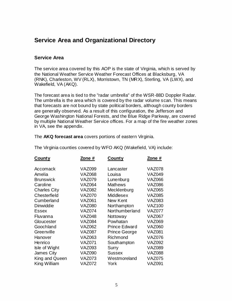
The service area covered by this AOP is the state of Virginia, which is served by
the National Weather Service Weather Forecast Offices at Blacksburg, VA (RNK), Charleston, WV (RLX), Morristown, TN (MRX), Sterling, VA (LWX), and Wakefield, VA (AKQ).
The forecast area is tied to the "radar umbrella" of the WSR-88D Doppler Radar. The umbrella is the area which is covered by the radar volume scan. This means that forecasts are not bound by state political borders, although county borders
are generally observed. As a result of this configuration, the Jefferson and George Washington National Forests, and the Blue Ridge Parkway, are covered by multiple National Weather Service offices. For a map of the fire weather zones in VA, see the appendix.
The AKQ forecast area covers portions of eastern Virginia.
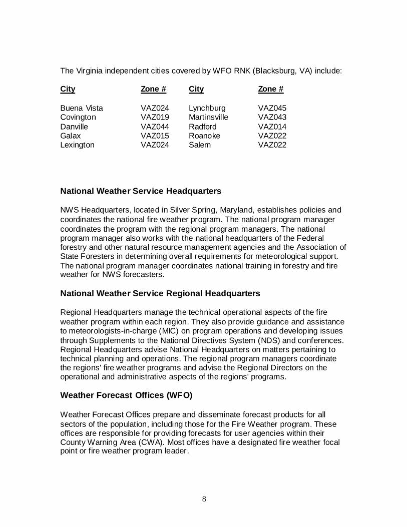
The Virginia counties covered by WFO AKQ (Wakefield, VA) include:
County Zone # County Zone #
Accomack VAZ099 Lancaster VAZ078
Amelia VAZ068 Louisa VAZ049 Brunswick VAZ079 Lunenburg VAZ066 Caroline VAZ064 Mathews VAZ086 Charles City VAZ082 Mecklenburg VAZ065
Chesterfield VAZ070 Middlesex VAZ085 Cumberland VAZ061 New Kent VAZ083 Dinwiddie VAZ080 Northampton VAZ100 Essex VAZ074 Northumberland VAZ077
Fluvanna VAZ048 Nottoway VAZ067 Gloucester VAZ084 Powhatan VAZ069 Goochland VAZ062 Prince Edward VAZ060 Greenville VAZ087 Prince George VAZ081
Hanover VAZ063 Richmond VAZ076 Henrico VAZ071 Southampton VAZ092 Isle of Wight VAZ093 Surry VAZ089 James City VAZ090 Sussex VAZ088
King and Queen VAZ073 Westmoreland VAZ075 King William VAZ072 York VAZ091
6
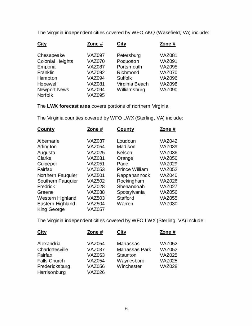
The Virginia independent cities covered by WFO AKQ (Wakefield, VA) include:
NWS Headquarters, located in Silver Spring, Maryland, establishes policies and
coordinates the national fire weather program. The national program manager
coordinates the program with the regional program managers. The national program manager also works with the national headquarters of the Federal forestry and other natural resource management agencies and the Association of State Foresters in determining overall requirements for meteorological support.
The national program manager coordinates national training in forestry and fire weather for NWS forecasters.
National Weather Service Regional Headquarters
Regional Headquarters manage the technical operational aspects of the fire
weather program within each region. They also provide guidance and assistance to meteorologists-in-charge (MIC) on program operations and developing issues
through Supplements to the National Directives System (NDS) and conferences. Regional Headquarters advise National Headquarters on matters pertaining to technical planning and operations. The regional program managers coordinate the regions' fire weather programs and advise the Regional Directors on the operational and administrative aspects of the regions' programs.
Weather Forecast Offices (WFO)
Weather Forecast Offices prepare and disseminate forecast products for all
sectors of the population, including those for the Fire Weather program. These offices are responsible for providing forecasts for user agencies within their County Warning Area (CWA). Most offices have a designated fire weather focal point or fire weather program leader.
9
The National Weather Service Weather Forecast Offices will provide 24-hour, 365 days a year service. The NWS WFO's can be reached at:
National Weather Service VA Tech Corporate Research Center 1750 Forecast Drive Blacksburg, Virginia 24060
National Weather Service
400 Parkway Road Charleston, West Virginia 25309
National Weather Service 5974 Commerce Blvd. Morristown, Tennessee 37814
National Weather Service 43858 Weather Service Road Sterling, Virginia 20166
National Weather Service 10009 General Mahone Highway Wakefield, Virginia 23888
NOTE: Unlisted telephone numbers used for coordination cannot be listed here.
All user agencies have been or will be provided voice and fax numbers to be used for official purposes only.
Meteorologists-in-Charge (MIC)
The Meteorologists-in-Charge is responsible for the provision of adequate
weather services for the offices' assigned areas of program responsibility. The MIC will ensure that the focal points or program leaders are provided adequate time for user liaison and assistance activities. MICs can be reached via email or through contact with their respective office:
Fire weather focal points and program leaders are the "customer service
representatives" for the program. The focal points or program leaders, as
representatives of the MIC's, are in regular contact with the partner agencies, helping them assess their meteorological needs, informing them of NWS products and services available to meet these needs, and educating them in the most effective use of the various NWS products and resources, including NOAA
Weather Radio (NWR). Focal points and program leaders will work with users to utilize existing NWS products and services produced for other programs that could meet the requirements of natural resource management. The focal points and program leaders are also tasked with ensuring staff meteorologists are
trained and remain proficient in preparing forecast products for support of the fire weather program. Fire Weather Program Leaders can be reached via e-mail or through contact with their respective office:
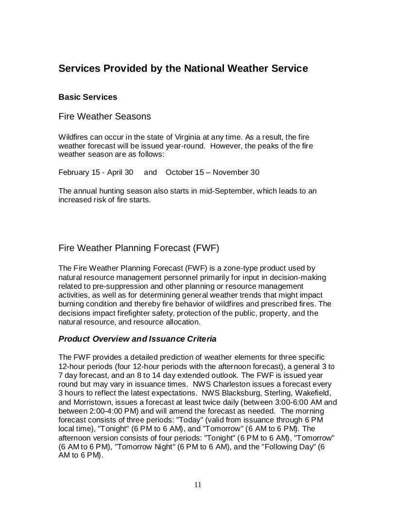
Wildfires can occur in the state of Virginia at any time. As a result, the fire weather forecast will be issued year-round. However, the peaks of the fire weather season are as follows:
February 15 - April 30 and October 15 – November 30
The annual hunting season also starts in mid-September, which leads to an increased risk of fire starts.
Fire Weather Planning Forecast (FWF)
The Fire Weather Planning Forecast (FWF) is a zone-type product used by
natural resource management personnel primarily for input in decision-making related to pre-suppression and other planning or resource management activities, as well as for determining general weather trends that might impact burning condition and thereby fire behavior of wildfires and prescribed fires. The
decisions impact firefighter safety, protection of the public, property, and the natural resource, and resource allocation.
Product Overview and Issuance Criteria
The FWF provides a detailed prediction of weather elements for three specific
12-hour periods (four 12-hour periods with the afternoon forecast), a general 3 to 7 day forecast, and an 8 to 14 day extended outlook. The FWF is issued year round but may vary in issuance times. NWS Charleston issues a forecast every 3 hours to reflect the latest expectations. NWS Blacksburg, Sterling, Wakefield,
and Morristown, issues a forecast at least twice daily (between 3:00-6:00 AM and between 2:00-4:00 PM) and will amend the forecast as needed. The morning forecast consists of three periods: "Today" (valid from issuance through 6 PM local time), "Tonight" (6 PM to 6 AM), and "Tomorrow" (6 AM to 6 PM). The
afternoon version consists of four periods: "Tonight" (6 PM to 6 AM), "Tomorrow" (6 AM to 6 PM), "Tomorrow Night" (6 PM to 6 AM), and the "Following Day" (6 AM to 6 PM).
12
Format/Content of the FWF
Format - The format of the Fire Weather Forecast is specified in National
Weather Service Directive 10-401. Some elements are optional and are not
included by all National Weather Service offices. Headlines - A headline is required when Red Flag Warnings and/or Fire
Weather Watches are in effect. The headline will include the warning type,
location, reason for issuance (e.g., high winds and low humidity), and effective time period(s). The headline is also included in the body of the FWF, in each appropriate zone grouping. Other headlines may be requested since the natural resource agencies are also considered "all risk agencies." When significant
weather trends of locally-defined critical weather elements are forecast or observed during non-watch/warning periods, they will be identified in the headline. Discussion - The discussion should be a brief, clear, non-technical description
of the weather patterns that influence the weather in the forecast area. Cloud Cover ("CLOUD COVER") - This is and indication of the expected sky
condition. "Clear" or "Sunny" descriptors are designated when the forecast cloud
cover is < 10%; "Mostly Clear" or "Mostly Sunny" are used when cloud cover is forecast to be >= 10% and < 30%; "Partly Cloudy" or "Partly Sunny" are used when cloud cover is forecast to be >= 30% and < 60%; "Mostly Cloudy" is used when cloud cover is >= 60% and < 80%; "Cloudy" is used when cloud cover is
forecast to be >= 80%. Precipitation Type ("PRECIP TYPE") - This refers to the predominant
precipitation type during the forecast period, with an exception. When both "showers" and "thunderstorms" are included in the public forecast,
"thunderstorms" will be designated as the precipitation type in the FWF. Chance of Precipitation ("CHANCE PRECIP") - Refers to the probability of
measurable precipitation (0.01 inches or more) during the forecast period. This
will be rounded to the nearest 10%. Note: Drizzle and snow flurries are not considered measurable precipitation and thus will not be given a probability. Temperature ("TEMP") - Refers to the forecasted maximum and minimum
temperature for the zone, in degrees F, as measured at a standard 4.5 ft above
the ground level. Relative Humidity ("MAX/MIN RH") - Forecasted minimum relative humidity is
provided during the daytime periods, while maximum RH is included at night.
Relative humidity is highly variable from site to site, but for the purpose of the zone forecast will be the maximum or minimum relative humidity within the zone. In general, relative humidity values below 25 percent should deter a prescribed burn and cause a call to the National Weather Service to obtain a site specific
forecast.
Note: The lowest average humidity typically occurs during the warmest part of
the day. However, if it is expected to occur at a different time of the day, this will be noted in the "Remarks" portion of the forecast.
13
Surface Winds ("WND20FT2MIN/EARLY and WND20FT2MIN/LATE") -
Surface wind speed and direction represent a two-minute average at 20 feet above the vegetative ground cover. Wind direction is the direction the wind blows from, to eight points of the compass. The "EARLY" designation refers to morning hours (before noon) during daytime periods, and also the evening hours (before
midnight) during nighttime periods. "LATE" refers to the afternoon hours during the daytime periods, and also the pre-dawn hours (after midnight) during the nighttime periods. Wind gusts, which are rapid fluctuations in wind speed of usually less than 30 seconds in duration, are indicated in the forecast if gustiness
is expected. Forecasts for highest probable gust will be preceded by "G". Precipitation Amount ("PRECIP AMOUNT") - Refers to the forecasted
precipitation amount (in hundredths of an inch) whenever the chance of precipitation is 25% or greater.
Precipitation Duration ("PRECIP DURATION") - Refers to the duration of the
measurable precipitation (in hours) when the probability of measurable precipitation is greater than or equal to 25%. A precipitation duration forecast of
"1" is used for "1 hour or less" duration. Precipitation Begin/End ("PRECIP BEGIN/END") - Refers to the time
measurable precipitation begins or ends. Mixing Height ("MIXING HGT") - Mixing height is defined as the atmospheric
limit above which vigorous vertical mixing does not take place. Mixing height forecasts are given in either feet above the ground ("FT-AGL"), or feet above mean sea level (“FT-MSL”). Note: If forecast units are provided in FT-MSL, you
must subtract your elevation height (terrain height above mean sea level) in order to obtain forecast units in FT-AGL. Transport Wind ("TRANSPORT WND") - Defined as the average wind direction
and speed from the surface to the top of the mixed layer. Direction of the
transport wind (where the wind is blowing from) and speed will be given. The speed will be in MPH. Ventilation Rate ("VENT RATE") - Refers to a multiplication of the mixing
height and transport wind., With units in ft MPH. Ventilation rates, forecasted during the daytime, are used to calculate the Burn Category for each day. The ventilation rate gives the potential for the atmosphere to disperse smoke. Refer to the appendix for further details regarding the correlation of the Ventilation Rate
and Burn Category. Note: This element is not generated by NWS Morristown. Dispersion ("DISPERSION") - Refers to the forecasted smoke dispersion
category at night, based on the surface wind speed. The dispersion category gives a general indication of the state of the atmosphere with respect to its ability
to disperse smoke. The dispersion forecast (nighttime) is analogous to the daytime Ventilation Rate, though only a forecast during the evening hours is provided as a large majority of controlled/prescribed fire operations are completed before midnight. A spot forecast is recommended for critical
operations that might involve smoke drift towards a populated area. Refer to the appendix for further details on Dispersion categories.
14
Lightning Activity Level ("LAL") - A numerical value, which is used to describe
the expected lightning activity for that day. Refer to the appendix for further
details on the LAL. Haines Index ("HAINES INDEX”)- The index infers the stability of the
atmosphere. In Virginia, for areas east of the Blue Ridge, "low elevation" is assumed for the calculation of the Haines Index. It utilizes the atmospheric
temperature at 950 MB and 850 MB as well as taking into account the moisture levels (dew point depression) at 850 MB. For areas along and west of the Blue Ridge, the "mid level" Haines Index is calculated using the temperatures at 850 MB and 700 MB, and the dew point depression at 850 MB. Haines Index values
range from 2 through 6. On western fires Haines Index values of 5 or 6 serve as an alert that fires or prescribed burns can experience control challenges. Local regional studies in North Carolina have shown that a Haines Index of 4 represents the initiating threshold whereby the atmosphere can support large fire
growth. In the absence of strong winds, fire growth will be primarily "plume dominated", with crowning and spotting on all sides. As wind speeds increase, coupled with a Haines Index of 4 or greater, there is an increased threat for large wind-driven fires.
Atmospheric Dispersion Index ("ADI" ) - A lower atmosphere atmospheric
dispersion index (ADI) forecast computed from the 20-foot wind speed, mixing height, transport wind, and cloud cover. The value reported is the average
maximum value for the fire zone, which filters out extremes. Refer to the Appendix for further details. Note: Included at WFO’s AKQ, MRX, and RNK. Low Visibility Occurrence Risk Index ("LVORI") - An index derived from the
ADI and the relative humidity, that gages the probability of visibility restrictions in
fog or smoke. The index is based on a study of traffic accidents in Florida. The value reported is the maximum value for the zone grouping, in order to capture the highest values. Refer to the Appendix for further details on LVORI categories. Note: Included at WFO's AKQ and RNK.
3 through 7 Day Forecast - The outlook period is an extended forecast for the
zone, or the entire forecast area, provided in narrative form (non-digital, non-tabular), and appended at the bottom of each zone grouping (for just that zone).
Outlook 8 to 14 Days - This section will only include temperature and
precipitation forecasts and will provide forecasts with respect to seasonal normal values for the specific time of year.
Update Criteria for the Fire Weather Planning Forecast
The Fire Weather Forecaster will maintain a weather watch to ensure that the forecast remains accurate. When unexpected changes occur, or are forecast to occur, which significantly deviate from the previous forecast, the forecast will be updated. The decision to update, to an extent, is at forecaster discretion. The
update criteria for various elements are listed in the Appendix. It is a shared responsibility for the WFO's and the natural resource agencies to monitor the need to update a forecast. Respective agency personnel will also provide feedback as to the updating of an FWF, NFDRS Point, or Spot Forecast.
15
Site Specific Forecasts (Spot Forecasts)
Criteria
Spot forecasts are special, non-routine forecasts prepared upon request of any federal agency, or state agency when there is some aspect of federal resources involved and/or interagency protection agreements currently exist, that needs site
specific weather forecasts for: 1) controlling the spread of wildfire; 2) planning and managing prescribed fires; or 3) other specialized forest management activities. In the event of an emergency which threatens life and/or property, spot forecasts can also be provided to any federal, state, or local agency.
Spot forecast requests for wildfires and hazardous material emergencies are considered high priority, and can be obtained at any time. Spot forecasts may be obtained for prescribed burns; however, the response may be delayed due to
higher priority responsibilities of the forecaster on duty.
Contents
Spot forecasts are highly detailed forecasts for a specific location within the forecast area. The format of the spot forecast is specified in National Weather Service Directive 10-401. The forecasts will be headlined for a Red Flag Warning or Fire Weather Watch. The forecasts will begin with a discussion, and
may contain any or all of the following weather elements: sky conditions; maximum and minimum temperatures, minimum and maximum relative humidity
values, wind speed and direction; probability of precipitation; precipitation type, duration and amount; mixing heights; transport wind; inversion height; inversion onset and burnoff times or temperatures; ventilation and smoke management levels; wind profiles; stability indices (IE., Haines Index), and lightning activity
levels (LAL). Since these are site specific and can be initiated because of critical circumstances, tailored products can be requested (e.g. temperature, relative humidity, and wind speed forecasts on a two hour incremental time period).
Procedures for Requesting a Spot Forecast
Spot forecasts will be prepared when requested by a user agency. Federal, state
and local agencies may request spot forecasts in support of wildfire suppression or other emergencies where lives and/or property may be threatened. Due to the detailed and specific nature of this forecast product, it is imperative that the user
provide the forecaster with necessary and sufficient information so that a reliable forecast can be prepared.
Requests for spot forecasts should be made using the web based spot forecast request form. This form, along with instructions on how to use it, is available on the local NWS fire weather web pages. The web based spot forecast request form should be filled out as completely as possible (required parameters are
listed in red) by the user agency prior to submitting the request. Use
16
Latitude/Longitude for your location, and this should be entered in either decimal degrees, or degrees/minutes/seconds. If you are using decimal degrees enter as standard (e.g. 37.52). If degrees/minutes/seconds, use a second decimal (e.g. 37.31.12), or leave a space between each number (e.g. 37 31 12).
Direct links to the spot monitor page for each NWS office:
In times when internet access is hindered or not possible, spot forecasts may be requested and disseminated via fax or phone. If faxing a request, users should use the Fire Weather Special Forecast Request Form, WS Form D-1. Section I of
WS Form D-1 should be filled out as completely as possible by the user agency prior to submitting the request by the fax to the forecast office. If the request is made by phone, all information in Section I should be provided to the forecast office.
While there is no dedicated fire weather forecaster , the forecast office will give a high priority to spot forecasts in the absence of weather phenomena in the CWA
that pose a threat to life and property. To ensure that the request for a spot forecast is handled properly and appropriately, users should adhere to the following guidelines:
1) Allow adequate time for the forecaster to prepare the forecast. This will normally be about 30 minutes. On particularly busy fire weather days, spot forecasts will be handled on a first-come, first-serve basis, with wildfires or other life threatening events taking the highest priority.
2) Provide as much on-site or near-site weather information as possible. At a
minimum, the user should provide at least one observation within an hour of the request. This observation must contain the following: location of the observation; elevation at the observation site; time of the observation; wind direction, speed, and level (eye or 20 foot); dry and wet bulb temperatures; any remarks about the
state of the weather, particularly anything that may affect fire behavior. If possible, include some observations from the previous day that might give the forecaster an indication of daily trends.
3) As much as possible, specify the time period for which the forecast is needed.
4) As much as possible, specify the weather elements of most importance for which a forecast is needed, and/or critical values of these elements.
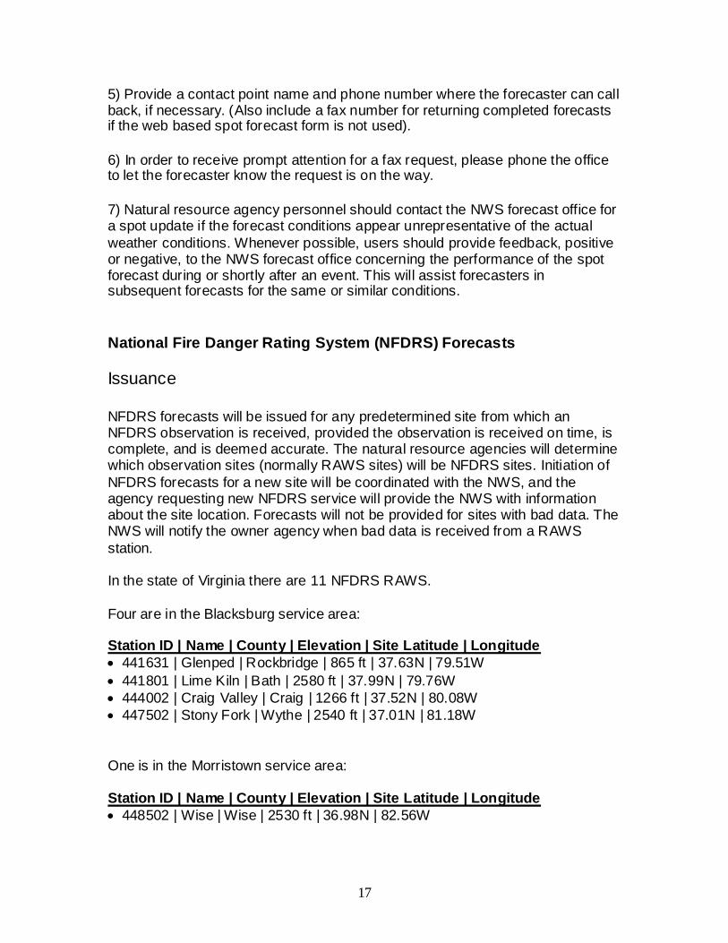
5) Provide a contact point name and phone number where the forecaster can call back, if necessary. (Also include a fax number for returning completed forecasts if the web based spot forecast form is not used).
6) In order to receive prompt attention for a fax request, please phone the office to let the forecaster know the request is on the way.
7) Natural resource agency personnel should contact the NWS forecast office for a spot update if the forecast conditions appear unrepresentative of the actual
weather conditions. Whenever possible, users should provide feedback, positive or negative, to the NWS forecast office concerning the performance of the spot forecast during or shortly after an event. This will assist forecasters in subsequent forecasts for the same or similar conditions.
National Fire Danger Rating System (NFDRS) Forecasts
Issuance
NFDRS forecasts will be issued for any predetermined site from which an NFDRS observation is received, provided the observation is received on time, is complete, and is deemed accurate. The natural resource agencies will determine which observation sites (normally RAWS sites) will be NFDRS sites. Initiation of
NFDRS forecasts for a new site will be coordinated with the NWS, and the agency requesting new NFDRS service will provide the NWS with information about the site location. Forecasts will not be provided for sites with bad data. The NWS will notify the owner agency when bad data is received from a RAWS
station. In the state of Virginia there are 11 NFDRS RAWS.
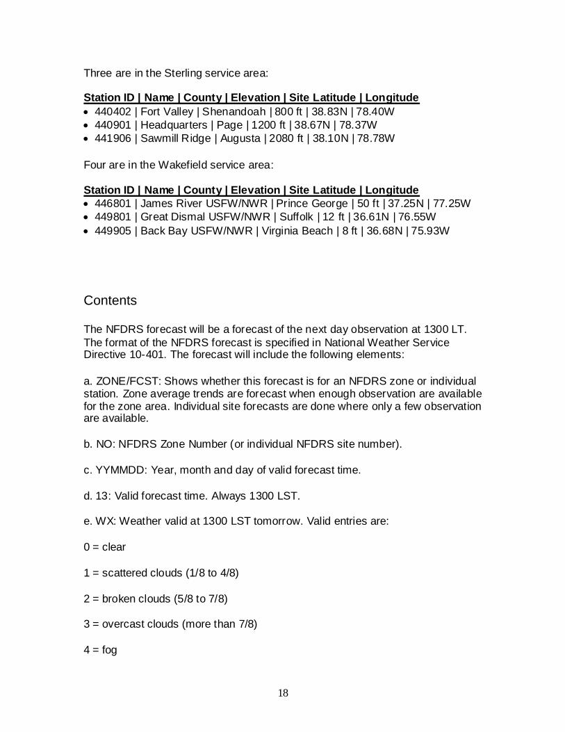
Four are in the Blacksburg service area: Station ID | Name | County | Elevation | Site Latitude | Longitude
441906 | Sawmill Ridge | Augusta | 2080 ft | 38.10N | 78.78W
Four are in the Wakefield service area: Station ID | Name | County | Elevation | Site Latitude | Longitude
446801 | James River USFW/NWR | Prince George | 50 ft | 37.25N | 77.25W
449801 | Great Dismal USFW/NWR | Suffolk | 12 ft | 36.61N | 76.55W
449905 | Back Bay USFW/NWR | Virginia Beach | 8 ft | 36.68N | 75.93W
Contents
The NFDRS forecast will be a forecast of the next day observation at 1300 LT.
The format of the NFDRS forecast is specified in National Weather Service Directive 10-401. The forecast will include the following elements:
a. ZONE/FCST: Shows whether this forecast is for an NFDRS zone or individual station. Zone average trends are forecast when enough observation are available for the zone area. Individual site forecasts are done where only a few observation are available.
b. NO: NFDRS Zone Number (or individual NFDRS site number).
c. YYMMDD: Year, month and day of valid forecast time.
d. 13: Valid forecast time. Always 1300 LST.
e. WX: Weather valid at 1300 LST tomorrow. Valid entries are:
0 = clear
1 = scattered clouds (1/8 to 4/8)
2 = broken clouds (5/8 to 7/8)
3 = overcast clouds (more than 7/8)
4 = fog
19
5 = drizzle
6 = rain
7 = snow or sleet
8 = showers (in sight or at the station)
9 = thunderstorm
(Categories 5, 6 or 7 sets NFDRS index to 0)
f. TEMP: Temperature in degrees F valid at 1300 LST (or temperature trend + or - degrees F).
g. RH: Relative Humidity in percent valid at 1300 LST (or RH trend + or - percent).
h. LAL1: Lightning Activity Level 1400 LST to 2300 LST.
i. LAL2: Lightning Activity Level 2300 LST to 2300 LST.
j. WDIR: Wind Direction. Used only for point forecast (FCST) version. Enter direction using sixteen point compass (N, NNE, NE, ENE, etc.) valid at 1300 LST (20 ft level, 10 minute average).
k. WSPD: Wind Speed. Enter wind speed in mph (or wind speed trend + or - mph) valid at 1300 LST (20 ft, 10 minute average).
l. 10HR: 10 hour timelag fuel moisture in percent valid at 1300 LST (or trend + or - percent).
m. Tx: Maximum temperature from 1300 LST to 1300 LST tomorrow.
n. Tn: Minimum temperature from 1300 LST to 1300 LST tomorrow.
o. RHx: Maximum relative humidity from 1300 LST to 1300 LST tomorrow.
p. RHn: Minimum relative humidity from 1300 LST to 1300 LST tomorrow.
q. PD1: Precipitation duration in hours 1300 LST to 0500 LST.
r. PD 2: Precipitation duration in hours 0500 LST to 1300 LST.
s. WETFLAG: Y or N. Indicates whether liquid water will be on the fuels at 1300 LST tomorrow. (Use with caution. A "Y" will set all the NFDRS indices to zero!).
20
Format. The NFDRS Forecast will follow the comma delimited format as shown:
The land management agencies are responsible for taking, quality controlling,
transmitting and archiving the NFDRS observations. Observation must be received at the NWS in a timely manner. Forecasts will only be prepared for predetermined sites, and only from those sites for which an observation has been received. The deadline for the land management agency for transmitting the
observation is 1900 GMT (2:00 PM EST or 3:00 PM EDT). The NWS will prepare and transmit the NFDRS forecasts no later than 1945 GMT (2:45 PM EST or 3:45 PM EDT). Although the data cutoff time for ingest into the NFDRS software is 7 PM, preliminary calculations based on the forecast are used by the land managers to make staffing decisions at shift briefing time (4 PM).
Fire Weather Watch and Red Flag Programs
During periods in which critical fire weather conditions are expected or imminent,
the NWS will issue statements, watches and warnings to describe the level of urgency to the appropriate user agencies. These issuances will be coordinated with natural resource agencies.
Definition of a Red Flag Event
A Red Flag Event occurs when critical weather conditions develop which could
lead to extensive wildfire occurrence or to extreme fire behavior. Red Flag Events represent a threat to life and property, and may adversely impact fire fighting personnel and resources. Critical weather conditions include combinations of the following: strong, gusty winds; very low relative humidity;
high to extreme fire danger (very low fuel moisture). Historically, the highest risk of significant fire starts and blow-ups occur when fuels are sufficiently dry and dry cold fronts pass over the region. Dry cold fronts
typically cause lower humidity levels and produce shifting and increasing wind. In an effort to simplify the Red Flag Warning process, forecasters at the NWS offices will mainly be concerned with the specific weather conditions and critical weather patterns necessary to produce Red Flag conditions. Tracking fuel moisture will be the responsibility of the fire product user agencies. As a result,
coordination will be necessary with the Virginia Interagency Coordination Center
21
(VICC) when a NWS forecaster considers a Red Flag Warning or Fire Weather Watch. If the VICC Coordinator (Center Manager) cannot be reached then coordination will be necessary with the federal land management agency having
the greatest fuels responsibility within the affected area (e.g. the USFS, NPS, or FWS), and the Virginia Dept. of Forestry central office in Charlottesville, VA. Generally, a Red Flag Warning will be issued when:
* Ten-hour fuel moistures are observed or expected to be 7 percent or less. This is an essential requirement and should be
coordinated with the Fire Management Officer at the Regional USFS office, or the Virginia Interagency Coordination Center. In the event coordination is not possible, the forecaster may, at his or her discretion, use the fuel moisture readings from the NFDRS RAWS.
-AND-
* Relative humidity is expected to fall below 30 percent at any
time over the forecast area and sustained wind of 20 mph or more. The sustained wind will be a two-minute averaged, 20 foot-level wind forecast. * For counties east of the Blue Ridge the air temperature must also be above 40 degrees Fahrenheit. See
Appendix for county listing.
During periods of extended drought or when wildland fires are occurring,
modifications to these criteria may be required. Any change will be coordinated through the Virginia Interagency Coordination Center, or with the Fire Burn Analyst (FBAN) and Incident Commander (IC) on an existing large project burn. We recognize there are seasonal variabilities that may stress live fuels
differently, in addition to other weather phenomena (such as, a frontal passage or thunderstorm downburst), that may result in extreme fire behavior and pose a hazard to wildland firefighters.
Red Flag Warning
A Red Flag Warning will be issued, after coordination with the appropriate natural
resource agencies, when a Red Flag Event is occurring or is imminent. The warning will be issued for all or a portion of the forecast area. It will be issued immediately once the forecaster and the appropriate natural resource agency have determined that a Red Flag Event is ongoing. Otherwise, it shall be issued
for impending Red Flag conditions when there is a high degree of confidence that conditions will develop within 24 hours. The warning will continue until the conditions cease to exist or fail to develop as forecast. At such time, the warning will be canceled. The format of the Red Flag Warning is specified in National Weather Service Directive 10-401. A sample Red Flag Warning is in the Appendix.
22
Fire Weather Watch
A Fire Weather Watch will be issued, after coordination with the appropriate
natural resource agencies, to advise of the possible development of a Red Flag Event in the near future. It will be issued for all or part of the forecast area. A Fire Weather Watch is issued when the forecaster and appropriate natural resource agencies are reasonably confident that a Red Flag Event will occur. A watch
should be issued 12 to 48 hours in advance of, but not more 72 hours in advance of, the expected onset of the critical weather conditions. The watch will remain in effect until either it is determined the Red Flag Event will not develop, or that the watch should be upgraded to a warning. If conditions are not expected to occur
as forecast, the watch will be canceled. The format of the Fire Weather Watch is specified in National Weather Service Directive 10-401.
Fire Danger Statements
When fire danger or fire occurrence is high and is coupled with critical weather conditions, user agencies may request that the NWS issue a Fire Danger
Statement. These statements will be issued in coordination with the requesting agency and will only be issued with their approval. The NWS will use the Special Weather Statement (SPS) for these issuances.
The following criteria will be used for Fire Danger Statements: RH within 5% of Red Flag Criteria (35% or lower).
And ASOS wind speeds within 5 mph of Red Flag Criteria (sustained 15 mph).
And 10-hr dead fuel moisture less than 10%.
These criteria may be waved for unusual or dangerous situations.
Participation in Interagency Groups
At a minimum, one NWS representative (usually the State Liaison WFO Fire
Weather Program Leader or MIC) will attend the State Interagency meetings or working groups where fire weather or smoke management policy is discussed as
an integral part of the meeting. However, it is strongly recommended that all NWS offices with fire weather responsibility attend the meetings to ensure uniform representation.
23
Special Services
Special fire weather services are those services that are uniquely required by
natural resource agencies and go beyond the normal forecast operations of the
NWS. Special services include Incident Meteorologist (IMET) deployment, station visits, training, and other pertinent meteorological services that are designated as non-routine.
Typically, special services require NWS personnel to be away from the Forecast Office and, in some instances, be in overtime status. User agencies are responsible for covering the cost of NWS overtime, travel and per diem
expenses. Reimbursement of costs for special services will be as outlined in the Interagency Agreement for Meteorological Services.
Incident Support
On-site forecast service support is available for wildfires and prescribed burns.
This includes the deployment of an Incident Meteorologist (IMET) and related service equipment such as the Atmospheric Theodolite Meteorological Unit
(ATMU), the All Hazards Meteorological Response System (AMRS), and the Fire Remote Automated Weather Station (Fire RAWS). The IMET, ATMU, AMRS, and the Fire RAWS are considered national fire fighting resources, and can be requested through the Virginia Interagency Coordination Center.
The ATMU and AMRS are modularized and mobile systems of equipment used by an Incident Meteorologist (IMET) for data collection and forecast preparation.
Only trained personnel will operate the ATMU and AMRS, and this service equipment will only be dispatched to an incident when a certified IMET is requested. The IMET is responsible for ordering and arranging shipment for the ATMU and AMRS.
There are 25 ATMUs cached across the country, mostly in the western states. The nearest ATMU cache to the state of Virginia is London, KY, where two are
maintained. AMRS workstations are also pre-positioned across the country,
most of which are collocated with existing Weather Forecast Offices that contain certified IMETS. These AMRS workstations are maintained by the IMETS and are typically shipped with the IMET being mobilized.
The ATMU is composed of one large shipping box consisting of a theodolite with tripod, a belt weather kit, PIBAL weather balloons, a nozzle and regulator for a
helium tank, and office supplies and miscellaneous expendables. Its volume is 13.8 cubic feet and it weighs 122 pounds.
The AMRS is also composed of one large shipping box, and contains a laptop computer, a satellite dish (BGAN) for obtaining weather data, a printer, and office supplies. The volume is 6.7 cubic feet, and its weight is about 90 pounds.
Total weight of the ATMU and AMRS is 212 lbs with a volume of 20.5 cubic feet. The cubic feet are necessary for shipment by air. The same specification shown is listed in the user agencies' National Mobilization Guide.
Requests for the ATMU, AMRS, and IMET should be made through the Virginia
Interagency Coordination Center. Typically, the IMET nearest the incident will be deployed. However, during times of limited resources, IMETs from other areas of the country may be called. The decision will be made by the Special Meteorologist to NIFC (SMC) in conjunction with the MIC and IMET from the
affected offices. It is the responsibility of the IMET to arrange shipment of the AMRS workstation.
The success of the operation depends in part on the user agency providing shelter and logistical support. Prior to the use of this equipment, the IMET is expected to have coordinated with the local user agency to ensure proper field support. If an IMET determines that an ATMU and/or Fire RAWS is desirable, it is
the IMET's responsibility to ensure the ATMU and Fire RAWS have also been ordered for the incident.
The requesting agency is responsible for any storage of service equipment while in transit, and shelter for the IMET and service equipment at the site. A sheltered work area, of at least 50 square feet with a table and chair, must be protected from excessive dust, free of standing water or condensation, and must be heated
and/or cooled sufficiently to allow efficient operation of equipment. Power (120V AC) must be provided for the AMRS's electrical equipment, and priority telephone access during certain short periods each day must be made available.
The procedure for requesting IMETs will follow the guidelines outlined in the national MOA, the National Mobilization Guide, and the Southern Area Interagency Mobilization Guide. The following information will be provided to the requested IMET:
1. Name of fire.
2. Location of fire.
3. Directions to location where the IMET is to report and the location of ICP.
4. Name of Incident Commander, Plans Chief, and FBAN, if available.
5. Request and Resource Order number for IMET.
Upon arrival at the incident and after going through the appropriate check-in procedures, the IMET will:
25
1. Brief the Fire Behavior Analyst (FBAN), Planning Section Chief (PSC), and the Incident Commander (IC) on current and expected weather as it affects the fire.
2. Establish a schedule with the IC and the FBAN for written forecasts and formal briefings.
3. Request a briefing of the fire situation and potential behavior problems from the FBAN. As time and resources permit, incident management
should arrange for an aerial inspection trip for the meteorologist and should provide the forecaster with current fireline maps. If possible, the IMET should be assigned a radio with the fireline frequency.
4. Arrange for a schedule of observations from key points around the fire and
from nearby lookouts and fire danger stations, in cooperation with the FBAN and PSC. On large fires, some personnel (at least two) should be permanently assigned to this duty. On smaller fires, this information can be provided by Division Supervisors equipped with belt weather kits.
IMET duties will vary with incident management team requirements, but the IMET is expected to provide daily weather forecasts for the incident, participate in shift
briefings, planning and strategy meeting, and coordinate daily with the local Weather Forecast Office (WFO) and /or other IMETs at nearby incidents.
Demobilization is initiated at the incident, and will be coordinated through the Virginia Interagency Coordination Center. Upon release, the user agency will transport the ATMU and Fire RAWS back to its cache location or to the controlling fire weather office. Travel arrangements will be made for the IMET
back to his or her home office. The IMET is responsible for transporting the AMRS workstation back to the home office. If the AMRS unit resides at a different location than the IMET, the IMET must make arrangements to ship the equipment to the proper office, and charge any shipping cost to the fire.
Other Special Services
Other special services may include weather station visits by partner agency
personnel, RAWS site surveys and inspections, weather observer training, and course development work or related program work. These activities would typically be at the full expense of the requesting agency unless other arrangements have been made.
NWS meteorologists may also be asked to assist in other non-routine services (e.g. briefings or coordination calls) during periods of high fire danger or fire
occurrence. MICs and Fire Program Leaders are to ensure the natural resource agency needs are met with little expense to either agency.
26
Fire Weather Training
NWS meteorologists will be available to assist in user-oriented training. This
includes fire behavior courses, such as S-190 and S-290, where the
meteorologist will serve as part of the cadre for that course. Requests for training assistance should be made through the NWS office's Fire Weather Program Leader or Meteorologist-in-Charge (MIC). Sufficient advance notice should be given to allow for scheduling and proper preparation. Costs incurred by the NWS in providing training assistance will be borne by the requesting agency.
Natural Resource Agency Responsibilities
Operational Support and Predictive Services
Program Management
The natural resource agencies will oversee the fire weather observation program, including the siting and maintenance of the observing equipment, fire weather training of their personnel, and the proficiency of their personnel in the use of the NWS Spot software.
Monitoring, Feedback and Improvement
Natural resource agencies will monitor the quality and timeliness of NWS fire weather products, and provide feedback to the NWS in order to improve services to the agencies.
Technology Transfer
The natural resource agencies may, from time to time, advise the NWS of new
technologies being implemented to monitor meteorological or fuel parameters, or to improve communication, coordination, training or reference. Natural resource agency personnel may, with prior arrangement, visit an NWS office to acquire a knowledge of NWS technologies used in the monitoring of weather, or the preparation of products.
27
Agency Computer Resources
Internet will be the primary method of obtaining the Fire Weather Forecast, Red
Flag Warning, Fire Weather Watch, and for both requesting and receiving a Spot Forecast. As a backup method, a request can be made to the NWS for a product to be faxed to the customer agency. NFDRS observations will be entered into WIMS, and forecasts and calculations based on these observations will be received by WIMS, or by internet via a WIMS website.
Fire Weather Observations
Fire weather observation stations provide the specialized weather observations for fire weather forecasts, wildfire control and suppression, and various other land management operations. These stations were selected very carefully in
each state and federal district. Sites were chosen to represent homogeneous weather conditions across a district. Stations may either be manned sites operated by land management agencies, or unmanned, Remote Automatic Weather Stations (RAWS) maintained by any of the federal or state land management agencies in the area.
All observation stations are assigned a 6-digit identification/location number. The
first two digits indicate the state, the second two digits indicated the county, and the last two digits indicated the consecutively-assigned station number for that county. Land managers who wish to have a number assigned to a station should contact the GACC meteorologist at SACC in Atlanta.
RAWS stations are also assigned an 8 character alphanumeric identifier based on satellite transmission time. The NESDIS ID, transmit channel and time are assigned by the US Forest Service National RAWS program.
Observations from a satellite telemetered RAWS will automatically flow into
WIMS via the NESDIS ID. If a station is not satellite telemetered, the data must be manually entered into WIMS. It is important the 1300 hour observation is quality controlled, as this observation will be used by the NFDRS. The RAWS owner must enter WIMS and manually change a recorded observation (an R ob)
to an observed observation (an O ob), manually enter the State of the Weather (SOW), and save the observation to WIMS. This action is generally applied only to the daily 1300 hour observation. Non-NFDRS stations are naturally exempt from these procedures.
Even with automated observations, the responsibility still rests with the RAWS owner to ensure that observations are being transmitted, recorded, and archived properly in WIMS. Automation greatly simplifies the daily process, however there
will still be the need for observations to be checked for integrity and consistency. Managing the NFDRS model parameters will still be a manual process in WIMS. Automation helps streamline the WIMS collective that is distributed to the NWS
28
via AWIPS. NFDRS forecasts are based on RAWS observations that appear on the daily collective and it is important these observations are accurate.
Sensor failure will often result in erroneous or (at best) suspicious values. If the NWS becomes aware of such a situation, it is prudent to contact the station owner. Similarly, if a station owner becomes aware of a sensor failure, he should relay that information to the appropriate NWS office. It is that station owner's
responsibility to make sure that their station is and remains in good working order and repairs are made in a timely manner. Owners of NFDRS stations can still (and should) correct any errors in their respective observations.
It is important to note, observations are the most important single effort the control agencies put into the Fire Weather Program. Potential fire danger is derived from these observations. The Fire Danger Rating System is the guidance tool that, together with the weather forecast, is used to make a variety of
management decisions. It is important that observers be well trained and informed of the necessity for accurate, timely, and representative observations.
On - Site Support
The user agencies are also responsible for maintaining observation site equipment. NWS personnel may accompany the user on maintenance trips or for annual inspection visits, which could also serve as liaison with the users.
Training
The responsibility of training natural resource agency employees will be that of the agencies themselves. However, the NWS will be available to assist when requested to do so. Any expenses incurred by the NWS will normally be charged to the user agency, unless other arrangements have been made.
Joint Responsibilities
Joint responsibilities include the following:
Meetings between the NWS offices and the natural resource
agencies.
The Virginia Interagency Coordination Center conducts at least two meetings per
year, roughly every spring and fall, with all natural resource agencies and NWS
offices serving Virginia invited to attend. These meetings typically will be held at the Virginia Department of Forestry Headquarters in Charlottesville, to minimize travel distance. Although the agenda includes many internal division matters they
29
are of interagency consequence. Therefore, the NWS is a Strategic Partner and is invited to these meetings since topics often include NWS operations.
Conference Calls.
During times of very high or extreme fire danger, the Virginia Interagency
Coordination Center (VICC) may initiate a conference call to discuss fire danger
and weather. This call may include various partner agencies, and either some, or all of the NWS offices serving Virginia, depending on the extent of the area of concern. When more than one NWS office is participating, VICC will ask one NWS office to lead the weather discussion, which may be followed by input from
the other NWS offices for their area. At times when the entire state is the area of concern, the NWS State Liaison Office in Wakefield will normally lead the discussion, but this may vary if the area of concern is skewed toward another NWS office's area. Conference calls will normally be held in the late morning, when NWS offices are beginning to consider their afternoon forecast package.
Maintenance and Revision of the Annual Operating Plan.
The AOP should be revised each year by the end of January, with cooperation and participation from each NWS office and each natural resource agency. The National Weather Service Office in Wakefield, Virginia, will be custodian of the
plan.
Notification of NWS Changes in Operating Procedures.
From time to time, NWS headquarters, or NWS Eastern Region Headquarters,
will send draft versions of future directives to their forecast offices for review and comment. To ensure that the natural resource partner agencies have an opportunity to review and comment on proposed changes, the NWS State Liaison Office in Wakefield will forward a copy of draft directives to VICC when
they are received. VICC will then forward draft NWS directives to the rest of the natural resource partner agencies for review. Comments and suggestions can be forwarded to the NWS State Liaison Office in Wakefield, which will forward them to NWS Eastern Region Headquarters.
Agreements on Services Provided.
Agreements on services and standards are normally reached at statewide meetings, but may be achieved at by a series of local meetings or by other means such as telephone or e-mail. NWS offices and land mangers should be
aware of the ripple effect an agreement might have on other NWS offices and their customers, particularly when service areas cross state lines.
Workplace Visits.
Natural resource agencies and the NWS collaborate on familiarization of personnel in each others fields of expertise, operations and equipment. Visits to offices and work centers, as well as field job sites can meet part of these requirements.
30
Service Evaluation.
Services provided by the NWS, and delivery of observations and information
from the natural resource agencies to the NWS in support of these services, shall be under constant evaluation by both parties.
Numbering and archiving of observation stations.
The GACC, when requested to do so by a natural resource agency, shall assign a station ID number for fire weather observation platforms. The land management agency will provide the station name, location (county,
latitude, and longitude), and elevation to the GACC meteorologist. The GACC meteorologist will assign the number and assist the station owner in establishing a station catalog in WIMS.
The numbering convention uses a six digit number, starting with 44 (for VA). The following two digit number designates the county, and the counties are numbered from 01 in the northwest, to 99 in the southeast.
The GACC meteorologist is responsible for maintaining a database of RAWS stations in their area. This information can be provided to the NWS regional program manager upon request.
The master list for the state of Virginia can be found in the appendix of this operating plan, which will be updated at least annually with any new or changed stations.
31
Effective Dates on the AOP
The effective dates of this Annual Operating Plan will be from January 1 through
December 31 of the current calendar year. This plan will be subject to review and revision by all signatory parties each year, or more frequently as operations warrant.
This plan will be available on the WFO fire weather web pages. A copy of this plan will be sent to NWS Eastern Region Headquarters by January 31 of the current year. Eastern Region Headquarters will forward a copy of the plan to NIFC and NWS Headquarters.
Signatory Page The following signatories have agreed to the terms and conditions of
this Annual Operating Plan, which is subject to revision on a least an
annual basis, or more frequently as operations necessitate. Actual
Fire weather zones consist of groups of counties (or occasionally single counties) selected based on homogeneous climatology and expected weather. These
groupings may change from forecast issuance to forecast issuance, and may contain counties from adjacent states served by the same NWS office. For a map of the VA fire weather forecast zones, click here.
Catalog of Fire Weather Observation Sites within the State of Virginia
Name; County; NWS Office; Station ID; Latitude; Longitude;
Elevation
BACK BAY; Virginia Beach; AKQ; 449905; 36.68 N; 75.93 W; 8'
Heathsville, VA; WXM-57; 162.400 MHz; Accomack, Essex, Gloucester, King and Queen, Lancaster, Mathews, Middlesex, North Hampton, Richmond, and Westmoreland.
Norfolk (Driver), VA; KHB-37; 162.550 MHz; Isle of Wight, James City, Surry, and York.
Pikeville, KY; WWG-69; 162.400 MHz; Buchanan, Dickenson, and Wise.
Phelps, KY; WWG-81; 162.500 MHz; Buchanan and Dickenson.
Richmond, VA; WXK-65; 162.475 MHz; Amelia, Charles City, Chesterfield, Cumberland, Fluvanna, Goochland, Hanover, Henrico, King William, Louisa, New Kent, Nottoway, Prince Edward, Prince George, and Powhatan.
The following weather criteria must be met, in addition to low fuel moisture:
Ten-hour fuel moistures are observed or expected to be 7 percent or less.
This is an essential requirement and should be coordinated with the Fire Management Officer at the Regional USFS office, or the Virginia Interagency
Coordination Center. In the event coordination is not possible, the forecaster may, at his or her discretion, use the fuel moisture readings from the NFDRS RAWS. -AND-
Relative humidity is expected to fall below 30 percent at any time over the forecast area and sustained wind of 20 mph or more. The sustained wind will
be a two-minute averaged, 20 foot-level wind forecast. For counties east of the Blue Ridge the air temperature must also be above 40 degrees Fahrenheit.
Note: During periods of extended drought or when wildland fires are occurring, modifications to these criteria may be required. Any change will be coordinated through the Virginia Interagency Coordination Center, or with the Fire Burn Analyst (FBAN) and Incident Commander (IC) on an existing large project burn.
We recognize there are seasonal variabilities that may stress live fuels differently, in addition to other weather phenomena (such as, a frontal passage or thunderstorm downburst), that may result in extreme fire behavior and pose a hazard to wildland firefighters
Click here for map indicating counties east of the Blue Ridge. This includes all counties in Wakefield’s (AKQ) service area. For Sterling’s (LWX) service area
this includes Culpeper, Fairfax, Fauquier, King George, Loudoun, Orange, Prince William, Spotsylvania, and Stafford. For Blacksburg’s (RNK) service area Appomattox, Buckingham, Campbell, Charlotte, Halifax, Henry and Pittsylvania.
Fire Weather Product Examples
Click here for the latest products from:
Blacksburg, VA (RNK): Red Flag ; Fire Weather Forecast ; Spot Forecast
Charleston, WV (RLX): Red Flag ; Fire Weather Forecast ; Spot Forecast Morristown, TN (MRX): Red Flag ; Fire Weather Forecast ; Spot Forecast Sterling, VA (LWX): Red Flag ; Fire Weather Forecast ; Spot Forecast Wakefield, VA (AKQ): Red Flag ; Fire Weather Forecast ; Spot Forecast
Click here for an example of a Fire Danger Statement .
Ventilation Rate (ft mph) and Associated Burn Category
0 to 33499 = 1
33500 to 44999 = 2
44500 to 59999 = 3
60000 to 111999 = 4
112000 + = 5
Dispersion Tables
Surface Wind (MPH) and Associated Dispersion Category
Near Calm = Stagnant
2 - 4 MPH = Very Poor
6 - 8 MPH = Poor
9 - 12 MPH = Fair
13 MPH + = Good
Lavdas Atmospheric Dispersion Index (ADI)
(Derived from 20ft wind speed, mixing height, transport wind, and cloud cover)
1 – 6 = Very Poor
7 – 12 = Poor
13 – 20 = Generally Poor
21 – 40 = Fair 41 – 60 = Generally Good
61 – 100 = Good
100+ = Very Good
41
Lightning Activity Level
LAL Categories
1: No Thunderstorms.
2: Cumulus clouds are common, but only a few reach the towering cumulus
stage. A single thunderstorm must be confirmed in the rating area. The clouds mostly produce virga, but light rain will occasionally reach the ground.
3: Cumulus clouds are common. Swelling and towering cumulus cover less than 2/10ths of the sky. Thunderstorms are few, but two or three must occur within the observation area. Light to moderate rain will reach the ground, and lightning is infrequent.
4: Swelling cumulus and towering cumulus cover 2/10ths to 3/10ths of the sky. Thunderstorms are scattered, but more than three must occur within the observation area. Moderate rain is commonly produced, and lightning is frequent.
5: Towering cumulus and thunderstorms are numerous, they cover more than
3/10ths of the sky and occasionally obscure it. Rain is moderate to heavy, and lightning is frequent and intense.
6: Same as #3, but dry (little or no rain reaching the ground).
Lightning Strokes
1: 0/min., 0/5 min., 0/15 min.
2: 1/min., 1-5/5 min., 1-8/15 min.
3: 1-2/min., 6-10/5 min., 9-15/15 min.
4: 2-3/min., 11-15/5 min., 16-25/15 min.
5: 3/min., 15/5 min., 25/15 min.
6: 1-2/min., 6-10/5 min., 9-15/15 min.
42
Low Visibility Occurrence Risk index (LVORI)
(Derived from ADI and RH; gages probability of visibility restriction)
1: Lowest proportion of accidents with smoke and/or fog reported (130 of 127,604 accidents, or just over 0.0010 accidents).
2: Physical or statistical reasons for not including in category 1, but proportion of accidents not significantly higher.
3: Higher proportion of accidents than category 1, by about 30 to 50 percent, marginal significance (between 1 and 5 percent).
4: Significantly higher than category 1, by a factor of 2.
5: Significantly higher than category 1, by a factor of 3 to 10.
6: Significantly higher than category 1, by a factor of 10 to 20.
7: Significantly higher than category 1, by a factor of 20 to 40.
8: Significantly higher than category 1, by a factor of 40 to 75.
9: Significantly higher than category 1, by a factor of 75 to 125.
10: Significantly higher than category 1, by a factor of 150.
FWF Update Criteria
Standard Air Temperature: +/- 5 degrees F.
Relative Humidity: +/- 5%.
Wind Speed and Direction at 20 ft AGL: +/- 5 mph and/or 45 degrees.
Precipitation POP, duration and amount: same as for public zones.
Transports Winds: +/- 5 mph and/or 45 degrees.
Mixing Height: +/- 300 m or 984 ft.
Dispersion: One category of change.
Note: Morning upper air soundings from nearby weather balloon sites should be examined for update criteria.
43
Record of Changes to the AOP
February 2014:
Under "Service Area and Organizational Directory," the Fire Weather Program Leader (focal point) for the National Weather Service Office in Sterling was changed. The new point of contact is Andy Woodcock.
Under “Services Provided,” the official Fire Season dates were changed. The spring season ending date was changed from May 15 to April 30 and the fall
season ending date was changed from Dec 15 to Nov 30. This complies with what the VDOF uses for the State of Virginia.
Under "Services Provided," added a new RAWS in Blacksburg's service area: Glenped; 37.63N, 79.51W, station ID 441631.
Under "Signatory Page," the Fire Management Officer for the George Washington and Jefferson National Forests was changed. The new FMO is Kyle Smith. Also changed the signatory for NWS Sterling to Andy Woodcock.
Under "Appendix," added one RAWS site: GLENPED; Rockbridge; RNK; 441631; 37.63 N; 79.51 W; 865'
March 2014:
Under “Services Provided,” additional guidance was provided for the issuance of
Fire Danger Statements. The following thresholds will now be used for the issuance of Fire Danger Statements: RH within 5% of Red Flag, AND Wind within 5 mph sustained of Red Flag, AND 10hr dead fuel moisture less than 10%.
Under “Services Provided,” additional guidance was also provided for the issuance of Red Flag Warnings. For counties east of the Blue Ridge, the air temperature must be above 40 degrees Fahrenheit in addition to the previously established criteria before considering a Red Flag.
February 2015:
Under “Service Area and Organizational Directory”, removed Bedford from the independent cities list.
44
Under "Service Area and Organizational Directory", the Fire Weather Program Leader (focal point) for the National Weather Service Office in Morristown was changed. The new point of contact is Tim Doyle.
Under “Services Provided by the National Weather Service”, removed Chincoteague RAWS from the Wakefield NFDRS station list.
Under “Services Provided by the National Weather Service”, removed the mention of “Blow-Up Alerts”.
Under "Signatory Page," the Fire Weather Program Leader for NWS Morristown was changed. The new FWPL is Tim Doyle.
Under "Appendix," added one RAWS site: SAWMILL RIDGE; Augusta; LWX; 441906; 38.10 N; 78.78 W; 2080'
Under "Appendix," removed one RAWS site: CHINCOTEAGUE; Accomack; AKQ; 449906; 37.9917 N; 75.2878 W; 5'
Under "Appendix," added 23 AWOS sites: Brookneal/Campbell County Airport; 0V4; 37.1417 N; 79.0164 W; 596’