i ough increased intensification along the coast is usually regarded today as an idea to be opposed, the present research is carried out in the hopes of providing a new paradigm through which higher density can be compatible with New Zealand’s coastal culture. e sprawling single detached house archetype for coastal occupation does not provide the necessary access to the coastal border that more concentrated development could. In order to address the limitations of the traditional coastal typology where universal direct access to the coastal border can be limited by sprawl, this research seeks to develop a sensitive response to the need for coastal density. Landscape is oſten misconstrued to be natural when in fact it is oſten quite the opposite. Landscape is an interpretation of site. is interpretation is dependent on understanding a site’s ecological, anthropological and archaeological characteristics. e Ecological Landscape is perhaps the most common method of seeing the site and is commonly mistaken as being synonymous with nature. It takes into consideration the site’s modified and natural features such as terrain and flora/fauna. Secondly, the anthropological facet of landscape considers its occupation and the political and social issues that affect the site. Lastly, a
Transcript
i
Though increased intensification along the coast is usually regarded today as an idea to be opposed, the present research is carried out in the hopes of providing a new paradigm through which higher density can be compatible with New Zealand’s coastal culture. The sprawling single detached house archetype for coastal occupation does not provide the necessary access to the coastal border that more concentrated development could. In order to address the limitations of the traditional coastal typology where universal direct access to the coastal border can be limited by sprawl, this research seeks to develop a sensitive response to the need for coastal density.
Landscape is often misconstrued to be natural when in fact it is often quite the opposite. Landscape is an interpretation of site. This interpretation is dependent on understanding a site’s ecological, anthropological and archaeological characteristics.
The Ecological Landscape is perhaps the most common method of seeing the site and is commonly mistaken as being synonymous with nature. It takes into consideration the site’s modified and natural features such as terrain and flora/fauna. Secondly, the anthropological facet of landscape considers its occupation and the political and social issues that affect the site. Lastly, a
iii
site’s Archaeological Landscape takes into account the ways in which previous occupation has left an imprint on the present form through physical artifacts and the methods engaged to maintain a link to its past. Through investigation along these three threads, a site’s true landscape is revealed is revealed as a sum of these aspects.
Although any approach that calls into question a prevailing bias against increased development is likely to become controversial, such controversy need not be synonymous with conflict. A nuanced view of landscape can reconcile various biases towards or against intensive development on sensitive sites. Such reconciliation is critical if we are to avoid a standoff that is bound to result from the pressures of an ever-increasing population and limited space, coupled with a fervent protection for areas of scenic beauty - the consequences of an overly simplistic dichotomy between stasis and progress.
Increased density often evokes ideas of confinement, which challenges the freedom associated with New Zealand’s inherent coastal culture. Absolute protection of the coastal border prohibiting further development compromises a central tenet of the New Zealand lifestyle. Current regulations do not acknowledge the possibility of designing empathically with the landscape so as to enable increased density while preserving the bach lifestyle. An understanding of the the site’s ecological character
v
enable the programme of the proposed development to be implemented while adhering to its defined area. Investigations into the Anthropological Landscape reveal the site’s layered occupation by Maori and European groups. Their modes of living provide the basis for tailoring formal and spatial design outcomes while the specific artifacts that have been found both on the site and in the vicinity are used to inform the underlying conceptual ideas and material characteristics. This expression of the site’s landscape enables the contemporary condition to maintain a dialogue with the past.
An in-depth relationship with landscape is necessary in order to design congruously in the contemporary New Zealand context. This is demonstrated through this proposal for higher density occupation on a sensitive coastal site. The resultant model expounds how opportunities for coastal living can be increased while preserving the values intrinsic to the New Zealand lifestyle.
Abstract ............................................................................... i.Part One
Introduction ...................................................................... 1.Chapter 1: The Ecological Landscape .......................... 11.Chapter 2: The Anthropological Landscape ................ 37.Chapter 3: The Archaeological Landscape .................. 63.
Part TwoChapter 4: The Design ................................................... 81.Conclusion ..................................................................... 153.Appendix ........................................................................ 163.
1
“When an architectural design draws solely from the tradition and only repeats the dictates of its site, I sense a lack of a genuine concern with the world and the emanations of contemporary life. If a work of architecture speaks only of contemporary trends and sophisticated visions without triggering vibrations in its place, this work is not anchored in its site, and I miss the specific gravity of the ground it
stands on.”1
To many, the word landscape simply implies the terrain and natural features of the location being discussed. Though the geomorphological and ecological aspects of site do constitute elements of a landscape, they by no means represent it in its entirety. The first part of this research serves to define landscape through its constituent layers of its Ecological, Anthropological and Archaeological characters. Through interpretation and consideration of these strata, it will be shown how proposed occupations of the site are able to respond sensitively, narrating the site’s genius loci and appreciating its existence as the contemporary layer in a coastal palimpsest.
It is often the Ecological layer of the palimpsest that is misunderstood to represent landscape in its entirety. However, as opposed to its observation as a static 1 Peter Zumthor, Thinking architecture, 2nd, expanded ed. (Basel: Birkhäuser, 2006). 42.
3
collection of elements, the understanding that it comprises dynamic and ever-changing ecological systems integrated with its geomorphology is crucial. The differentiation between nature and artifice is also fundamental. Though elements of nature compose the scenes commonly taken as landscape, the latter is seen as a representation of the former. Due to human activity and ideologies (The Anthropological Landscape) the majority of land and its ecosystems has been shaped by our influences and often quite significantly. Hence it must be accepted that although natural systems have a role in the formation of our environments, the often hidden artifice of human intervention must also be acknowledged. In doing so, the current viewpoints regarding protection of so-called ‘natural landscapes’ are challenged so that the outcomes of future development respect a sensitive connection to the site.
The Anthropological Landscape represents the social and cultural issues relevant to the site as a consequence of human occupation. Taken as a collection of layers that reflect various instances of occupation of the site, an understanding of the cultural relationships to the land and nature underlies spatial manifestations and treatment of social constructs. In the comprehension of these aspects and their effects on social logics, the relevance of current systems such as those that define our boundary-making and spatial arrangements can be questioned.
5
The subsequent reinterpretation of these methodologies, addressing both the history that enables our being while creating solutions that exemplify contemporary views and relationships, enables a considered architectonic response. This response will address the new social pressures exerted on the site, such as the continued increase in population and the resultant need for higher density, combined with a respect for the vernacular.
Through the layers of the Anthropological Landscape, there remain physical vestiges of inhabitation in the form of archaeological remains and artifacts. As the tangible elements of an understandable but unknowable past, the trappings of history have become intertwined with the ideas of identity and place-making. Although the analytical protection and display of artifacts as objects is imperative to an appreciation of history, the potential interpretation of these relics into architectonic cues must be considered. Identity and belonging is often assumed through the reproduction and repetition of heritage characteristics and traditions; from idyllic country towns to the appeal of vintage-styled products. Through the assumed connection between heritage and identity, though comforting, a site is engendered with a generic history. For the narration of its true historic characteristics, a site must appeal to individual human responses. An understanding of place requires both the evocation of remembered experiences as well as the
7
formation of new memories. Contemporary interventions within the coastal palimpsest must therefore present a narrative of history that relies not on the presentation of the object, but manifests as a framework for interaction and experience.
The impacts of these strands on the landscape, and hence identity, is largely unconscious. It is through the understanding and appreciation of these elements that the genius of a place is expressed. The application of these ideas to a theoretical proposal for development is undertaken on a sensitive coastal site. The site is at present regulated by stringent bureaucratic controls that seek to preserve elements of a landscape misconstrued to be natural. The coming decades will experience increases in population: with an intrinsic coastal culture and an aversion to increased density, these conflicts must be resolved in order to provide sensitive responses through the design of future developments. By addressing the antecedents to current thinking throughout the three threads of landscape, a new paradigm for coastal developments is explored.
11
“Although landscapes are created by humans, many landscapes conceal this human intervention.”2
The Ecological Landscape is composed of both the natural features of a site, as well as the modification of these elements. Nature is defined as “the phenomena of the physical world collectively…features and products of the earth, as opposed to humans or human creation.”3 Although the Oxford Dictionary includes landscape in its definition of nature, this dialogue aims to challenge this idea of landscape as a singular entity equivalent to nature and to present it as an integral part of the Ecological Landscape; an element of landscape as a palimpsest. It can then be understood that the effects of nature - wind, rain, tides and the like – on the geomorphology and ecology are responsible for natural creation and modification within the Ecological Landscape. In contrast, the effects of erosion due to repeated foot traffic can then be identified as human modification.
2 Susan Herrington, On landscapes, Thinking in action (New York: Routledge, 2009). 4.3 Angus Stevenson and Lesley Brown, Shorter Oxford English dictionary on historical principles, 6th ed., 2 vols. (Oxford ; New York: Oxford University Press, 2007).
13
Landscape architect and academic Susan Herrington identifies the ‘made’ quality of what is commonly seen as a natural landscape, “landscape is the hidden art. It’s everywhere and it’s part of everyone’s life.”4 Art and its creation are purely the result of human intellect, necessitating interpretation and emotion5. Yet despite the ubiquity of the so-called landscape, elements of human authorship are largely disregarded. Art on such an omnipresent scale, it seems, can be easily mistaken as being beyond our capabilities. In additions to the issue of scale, the imprints of human interaction occur whether consciously undertaken or not. Often as an unconscious art, modification of site is passed off as the result of natural formation. It can then be seen that conflicted authorship of Ecological Landscapes is at the roots of widespread misconceptions of landscape as natural6. The human element in the Ecological Landscape must be understood with a certain level of distance from, but also in conjunction with, nature’s contributions. This dialectic between nature and artifice is the terrain of the Ecological Landscape.
4 Herrington, On landscapes: vii.5 Stevenson and Brown, Shorter Oxford English dictionary on historical principles.6 Herrington, On landscapes: 28.
15
We Occupy A Modified Construct
“humans create landscapes, so we should identify landscapes as artifice, not as external nature.”7
At our stage in history, the majority of Ecological Landscapes around us cannot be thought of as untouched by human influence. Human interference has in effect turned us, at least in part, into the designers of these Ecological Landscapes. They are also continually affected by natural processes over which humans have no direct control that impact significantly on their character and appearance over time.
Several of the areas that are thought to be ‘natural landscapes’ today are in fact man-made spaces. An example of this is New York’s Central Park:“people visiting New York City often think that Central Park was just there, and the city was built up around it, with designers adding buildings, roads, fountains, and paths along the way. They are unaware of the massive physical transformations made to the 341 hectares of swamp land and rock outcrop in the nineteenth century. These transformations involved the importation of four million cubic meters of dirt for fill and hill creation, rock blasting that required 350 metric tons of gunpowder, planting 270, 000 trees and shrubs, and tragically, the removal of one of Manhattan’s first African American villages, Seneca, which was home to 1600 people.”8
7 Ibid., 7.8 The Library of Congress, “Today in History: April 26,”
17
The extensive use of natural elements – soil, rock, plants – within a composition does not in turn transform the final result into a natural scene. However, the tendency to readily accept these artworks as nature has lead to the protection of areas based on this falsity. People will assume that a place is a part of the natural landscape if it has the appearance of having been in existence for a while, or its brevity of existence is masked by prolific vegetation. This tendency is acknowledged by Bridget Baines, lead designer for landscape architecture firm Gross Max when she noted that “if you want people to take your landscape as a given, plant fast-growing trees and grasses, and people will fight to save them.”9 It is this readiness to protect the appearance of nature that has lead to New Zealand’s fierce protection of scenic areas of the Ecological Landscape.
It could also be seen that New Zealand’s “clean, green” marketing methodologies have also contributed to this enthusiastic preservation, with public support both stemming from and occurring because of these attitudes. Claims such as “Coastal development threatens landscapes and eco-systems through out New Zealand. Our coastline’s natural character is being eroded by rampant development”10 by groups such as those focused on ‘saving’ areas such as Te Arai11 often omit the fact that these Ecological Landscapes have in fact previously been occupied and modified. memory.loc.gov/ammem/today/apr26.html.9 Herrington, On landscapes: 30.10 Grant La Hood, “HELP SAVE Te Arai,” http://www. savetearai.co.nz/.11 an area less than 50km South of Smugglers Bay, the site chosen for this design proposal
19
Though the area may appear as “untouched New Zealand coastline being developed for housing…”12, previous Maori occupation is responsible for the established forests that are included in this stretch of supposedly ‘untouched’ coast. The concerns for areas such as these are largely conservational; at Te Arai, there is great concern for the New Zealand Fairy Tern (New Zealand’s rarest bird) among several other species of avifauna13. Though it cannot be argued that development will not impact the ecologies of the site, appropriately designed higher intensity developments within a contained area can assist in the prevention of excessive deterioration of natural habitats, and can enhance conservation initiatives. It can also be demonstrated that the limited footprints and sensitive responses of these potential developments can provide far superior amenities and ecological outcomes as compared to current patterns of gradual yet relentless sprawl. This alternative method of occupation is presented in the light that populations will continue to increase and the allure of New Zealand’s scenic coastlines will persevere.
Demand for occupation and development will, as a result, continue to rise. By preventing sensitive development initiatives that enriches these areas and contribute another layer to our fecund coastal palimpsest, current development values exacerbating sprawl will prevail. 12 La Hood, “HELP SAVE Te Arai”.13 J.E. Dowding, “Potential Impacts On Shorebirds Of A Proposed Subdivision At Te Arai, North Auckland,” (DM Consultants, 2006), 5.
21
The resistance to development of coastal areas is indicative of a type of “anti-development sentiment”14 as observed in J.S. and Nancy Duncan’s study of the residents of Bedford. The study set out to illustrate that aesthetic qualities of landscape and their protection are enmeshed with a society’s class system, hierarchy and identity. The occupants of Bedford maintained specific characteristics in order to portray an image of ‘natural’ development – applying an aesthetic code that implied a longevity of existence and therefore, of belonging to the Ecological Landscape. The proposal for a newer development at Bedford was met with strong opposition on the basis that it would degrade its beauty and reduce its appeal. Fundamentally, these attitudes are indicative of views that nature and belonging to nature is ‘good’, whereas deviation from the natural must in turn be ‘bad’. In turn, these sentiments became apparent with the acceptance that scenes mimicking nature were ‘good’, and those that expressed their manmade characteristics were ‘bad15. The negative connotations surrounding modern proposals in coastal areas and occupations carries similar tones to the views regarding new development in Bedford. The convergence of nature with moral integrity can be thought to stem from an established dialogue between nature and humanity.14 James S. Duncan and Nancy Duncan, Landscapes of privilege: the politics of the aesthetic in an American suburb (New York: Routledge, 2004). 76.15 Herrington, On landscapes: 7.
23
Views On Nature And The Perceived Landscape
“I avoided ever using the oxymoron ‘the natural landscape’.”16
The discourse surrounding landscape is vast, with most theorists and those inclined to discuss the topic eager to admit the ambiguities it entails. The Ecological Landscape is a concoction of ideas and theories tempered with, according to all those involved in its discussion, matters of perception. Its vastness of interpretation stems from its multitude of facets, from its representation of nature as an artistic genre to its importance as our immediate environment imbued with the ideologies of our predecessors.
Human relationships with nature have been expressed through a variety of attitudes towards the Ecological Landscape. The idea that nature is ‘good’ can be seen as stemming from theological belief systems. Many of these ideological systems tend to see nature as some form of origin for man. Residents of Te Arai refer to the their location as the “Garden of Eden.”17 As the setting for Adam and Eve, the Garden of Eden underlies the concept that nature has existed since time immemorial and is integral to human existence. Te Arai’s Ecological Landscape seen as correspondent to nature posits it as 16 Geoff Park, Theatre country : essays on landscape & whenua (Wellington, N.Z.: Victoria University Press, 2006). 9.17 Dylan Thorne, “Te Arai: We don’t want Orewa II,” The Northern Advocate(2006), http://www.northernadvocate.co.nz/news/te-arai-we-dont-want-orewa-ll/960478/.
25
‘good’ and morally decent and insights its protection. Though by no means the only belief system with strong connections to nature, European adherence to Christianity has influenced much of today’s Ecological Landscape through its interpretations. Long-standing traditions of modifying terrain and gardens to be representative of our origins is a result of this connection. Within the realm of landscape design, the twentieth century saw efforts to artfully reproduce scenes representative of nature; that is, as if they were a product of nature as opposed to man.
“As a result, signs of human authorship in the design of landscapes were often disguised. Artificial stone was carefully crafted to simulate rock outcrops, soil was imported and shaped to mimic the land forms left by some long-departed glacier, and vegetation was installed to resemble naturally occurring ecosystems, such as meadows.”18
Subsequent challenges to belief systems and the emergence of scientific theories regarding both our origins and nature were visible in society’s treatment of the Ecological Landscape.
Perhaps the way in which nature as system is interpreted – static or dynamic – has also determined the ways in which we react to the Ecological Landscape. A static interpretation of natural systems appeals to the notion that ecosystems occur in a specific location.
For example, bioregionalists attempted to define political areas based on the boundaries demonstrated by ecological 18 Herrington, On landscapes: 5.
27
communities. As Herrington comments however, to “freeze life in a geographic region is to counter nature, its evolutionary processes of spatial diffusion though exchange and migration.”19 This can be seen as in conflict with the concept of a dynamic ecological system where the community as a whole adjusts and adapts and is accepted as in a state of continual modification. Darwin’s The Origin of Species fostered a change in understanding from the static to the dynamic. This mode of thought viewed nature as in a constant state of flux, liberating new understandings of both the human role in nature’s framework and our relationship to it. The dichotomy between nature as origin and nature as constantly changing draw significantly different outcomes. In a different stance to twentieth century landscape designers,contemporary efforts often reveal their manmade origins in an attempt to clarify their presence as distinct from
nature’s product and include in their designs a capacity for change20. Should coastal sites be seen within a system of perpetual evolution, propositions for coastal developments might be more readily embraced.
Although our ancestors’ treatment of the Ecological Landscape was influenced by their relationships to nature, this by no means indicates that it was anything less than dramatic.
It is often idealized that our predecessors led a life in tune with nature. In fact, early civilizations are responsible 19 Ibid., 56.20 Ibid., ix.
29
for drastic reconfigurations of terrain and disruption to ecosystems. The following examples given by Herrington indicate the extent to which some of our earlier societies modified our Ecological Landscape:
“the quest to build ships in Europe – for trade as well as war – depleted the continent of prime timber, which in turn increased flooding of urban areas, damaged crops, and reduced the amounts of wild game for hunting. When Europeans discovered America, many of its inhabitants had already dramatically shaped the land with massive effigy mounds and artificial mountains, such as Monk’s Mound in Illinois (800 – 1350), and extensive roadway systems, such as the remarkably straight roads made by the Anasazi (900 – 1150). As Europeans began farming North America they faced the vagaries of extreme weather (such as droughts), pest infestation, resource depletion, and labor shortages. We also know their farming practices were often wasteful, and did not contribute to sustaining a collective life with nature.”21
Nature writer and ecologist Geoff Park in discussions regarding both the Pacific awareness of nature and the fusing of modern and traditional conservation techniques notes that customary life as a part of nature “had to include wasteful exploitation and the gradual depletion of a resource as much as observation of nature’s rhythms and phenomena.”22 With such impetus towards 21 Ibid., 35-36.22 Park, Theatre country : essays on landscape & whenua: 15.
31
environmental modification, it can only be through willful ignorance that today’s Ecological Landscapes are accepted as natural.
Outstanding Landscapes
“Post-modern people are proverbial tourists, seeking to imbibe the histories of other times and/or cultures as part
of who they are.”
Areas of Ecological Landscapes have so convincingly portrayed themselves as established features that bureaucratic regulations now preserve their vast exhibitions of unquestioned nature.
Although an element of cultural significance and heritage are said to affect the identification areas as Outstanding Landscapes, the decision is based primarily on aesthetic qualities present in the Ecological Landscape. Because of this, the discussed issues of the human relationship with nature and its societal interpretations are brought to the fore.
Throughout policy documents outlining the need for preservation of these areas, it can be seen that nature is
33
viewed as a static system where any change is viewed as negative. Modification of these areas disregarding the wider context would be detrimental, but all change cannot and should not be avoided. Natural processes are also viewed as both positive and negative, with influences that maintain the current features of an Ecological Landscape viewed as acceptable while those that modify to effect a permanent change in the terrain are threatening.
“The primary causes of impacts on outstanding natural features and landscape are natural processes (e.g. floods or erosion) and human activities. While natural processes such as erosion and weathering may slowly degrade some landscapes or features, they can also maintain others such as dune systems and exposed rock outcrops. There is generally little justification for interfering in these processes. Human activity can have significant impacts on natural features and landscapes…Human activity can also modify natural processes and thereby worsen erosion, change waterways and / or increase the impacts of pest plants and animals.”23
Outstanding Landscapes in the Northland context aim to encourage a “cultural and social identity, providing a sense of ‘place in the world’ and a source of intrinsic public value.”24
23 Northland Regional Council, “Outstanding Natural Features and Landscapes,” in New Regional Policy Statement - Background Documents (Northland Regional Council), 4.24 Ibid., 1.
35
At present, the cultural and social identities represented by these designations are remnants of dated theories and irrational fears of change. As context and circumstances evolve, the perpetuation of these philosophies will only serve to amplify the disjoint between progress and identity.
37
Before any form of direct human interaction with a site, the landscape is made up of simply the Ecological Landscape; that is, the Anthropological and Archaeological Landscapes only come into play once an instance of human interaction has occurred. Once the site has experienced a form of human occupation, an understanding of the living patterns that were applied to the site becomes important. The denizen society’s relationship with land underlies many of the spatial characteristics of a settlement, including issues of boundary-making and density.
Phases Of Occupation And Their Relationship To The Land
Before 900 AD, the estimated arrival of Maori to Aotearoa25, it could be assumed that the tripartite landscape was analogous with nature; untouched by any form of human occupation. Their arrival marked the start of a change in landscape. Though their arrival would physically alter the terrain on which they existed (the Ecological Landscape), Maori cultural attitudes and perceptions of relationship to the land are antecedents to political issues we still face today.
25 Tanira Kingi, “Maori landownership and land management in New Zealand,” ed. Australian Agency for International Development, Volume Two - Case Studies on customary land and development in the Pacific (2008).
Plate 1. Attitudes towards land ownership and boundary.
EURO
PEAN
IDEA
LPR
E-EUR
OPEA
N ID
EAL
39
This first phase of occupation marks the inception of New Zealand’s Anthropological Landscape.
The second phase of occupation in New Zealand’s settlement history can be recognized as the arrival of British settlers in the 1840s. New Zealand was discovered
by Tasman approximately 200 years prior to this point in history, with several successive events facilitating contact between European and Maori including Cook’s arrival in the late 1800s and the arrival of missionaries in the early 1900s. Although these events initiated change in existing Maori societal values, Britain’s efforts in colonizing New Zealand imposed the strongest ideological changes on the Anthropological Landscape.
As opposed to the sole ownership model that prevails in current, post-settlement society, for Maori land titles were not held by a single person or commodities to be traded. This attitude toward the land can be reduced to a matter of how people’s relationship to the land was seen; that people own the land (European ideal)26 or belong to the land (pre-European ideal) - Plate 1.
26 “When capitalist economies and industrial practices developed in Northern Europe, and eventually in North America, the notion of land as the bearer of sustenance was supplanted with land as property. This altered our relationship with land from appreciating its productive capacities to support life and structure society to envisioning it as simply another commodity for acquisition along with jewels, cars, and clothing.” Herrington, On landscapes: 34.
41
This idea of the land (Ecological Landscape) having more significance than the people who inhabit it stems from the customary creation myth that
“humans were produced from a union between earth mother (papatuanuku) and sky father (ranginui). The Maori term for land, whenua, also means placenta and the term for people, tangata whenua, means born of the earth’s womb. With these beliefs and the understanding that land is permanent and human life is transient, Maori considered the association with land more in terms of ‘belonging to’ rather than ‘owning’.”27
Though of concern to Maori, because of this hierarchical importance of the land over people, land ownership was seen in less definite terms than the ideologies assumed by settler beliefs. Groups – iwi, hapu, whanau28 – exercised differentiation in rights of use of certain areas, but assumed no supreme ownership of the land occupied. These groups could all potentially occupy the same or overlapping land areas but had rights to different activities within them; one group could fish in an area while another would cultivate crops.29
27 Kingi, “Maori landownership and land management in New Zealand.”28 Iwi means tribe, hapu are the clans/groups within an iwi, and whanau means family or extended family that make up the hapu.29 Jim McAloon, “Land ownership - Maori and land ownership,” Te Ara - the Encyclopedia of New Zealand, http://www.TeAra.govt.nz/en/land-ownership/1.
43
It is these discrepancies in understanding, and potentially, their exploitation by settlers that has lead to current and prolonged debates regarding the Treaty of Waitangi.
These ownership values are indicative of the societal focus on the group as opposed to the individual. As a consequence, treatment of boundary conditions within Maori settlements reflects these communal tendencies.
Living spaces and huts are grouped in areas that are fenced off, with shared cooking facilities. The communal mentality has manifested in the formation of structures designed for a singular activity undertaken by a large group, such as the wharekai (eating house) and wharenui (meeting house).
In stark contrast to the view that people are of the land, British settlers were influenced by a more Darwinian view and hence, a will to assert their dominance over the land. As one of the first moves in creating a British colony, Edward Gibbon Wakefield and the New Zealand Company proceeded to subdivide New Zealand’s terrain into gridded sections to be easily traded, irrespective of topography and the existing Ecological Landscape30. Once seen as a commodity to be bought and sold, claims were staked and boundaries became both fiercely defined and protected.
30 Park, Theatre country : essays on landscape & whenua: 36.
45
The potential for outright ownership has meant that over time the result has been “quarter-acre suburban sprawl, where Arcadian privacy and equal opportunity preserve the boundless country of the colonial mind.”31
In a sense, the colonial method of boundary-making employed in the preliminary subdivision of New Zealand can be seen as an extension of Britain’s ‘political landscape’. Though landscape historian J.B. Jackson’s context for his example of the ‘political landscape’ is the United States, the following observation is relevant to our austral context:
“the boundary in a political landscape often bears little relationship to the society within it…In the nineteenth century we created a number of states which were in effect immense rectangular spaces having no relation to the topography of population.”32
This disconnect between boundary and the society it contains can be seen as an evolutionary byproduct of the imposition of original settler relationships to the land over time; imposing a rigid, rational organization to “nature’s empty chaos.”33 Over time, society has simply reiterated and reproduced colonial logic, perpetuating a system of boundary-making that was never intended to address the densities of occupation that we face at present.
31 Ibid., 48.32 John Brinckerhoff Jackson, Discovering the vernacular landscape (New Haven: Yale University Press, 1984). 14.33 Park, Theatre country : essays on landscape & whenua: 48.
47
The way in which this has elicited a tendency for sprawl is elaborated by Jackson, “when dwellings were of necessity brought closer together in towns and cities, the sacred enclosure persisted in the form of a low wall, a ditch, or even a mere open space a few feet wide.”34 Even as rectangular plots become smaller and the need for dwellings in closer proximity arises, there prevails an inherent need to define “the linear boundary, duly surveyed, registered, and indicated on the landscape...”35
New Zealand’s Northland region is expecting a population increase of 12.5%, and within that an increase of 20% by Whangarei36. Being an established holiday area, as the resident population of these areas increase, it can be expected that the transient tourist numbers will also rise. With no part of Northland being more than 40km from the coast, the conflict between people and space arises. Northland, and New Zealand in general, has a strong coastal culture. This stems, assumedly, from a variety of notions including our proximity at any point within the country to the coast, endemic creation myths and values, as well as the curiosity that much of our current post-colonial population have not “drifted from the beachheads of first arrival.”37 That a significant proportion of New Zealand coastal regions are protected 34 Jackson, Discovering the vernacular landscape: 14.35 Ibid., 15.36 Northland Regional Council, “Infrastructure,” New Regional Policy Statement: Background Documents, 3.37 Park, Theatre country : essays on landscape & whenua: 49.
49
as D.O.C Public Conservation Land and Outstanding Landscapes in particular then poses a dilemma for population growth. The dilemma arises not in reaction to this classification and protection of coastal land, but to an innate predisposition to oppose development proposals that deviate from our construct of the organizational grid and boundless sprawl.
Population increase invariably leads to questions of where these increased numbers will occupy, and the want to settle in coastal regions is unwavering. In order to best satisfy both protection and habitation needs, increased density within defined bounds will become a necessity; preserving public access while providing habitable areas. However, models of development appear to consistently incorporate the legacy of nineteenth century political boundaries of rectangular plots, clearly distinguishing ownership of ‘mine’ and ‘yours’ and the power of ‘us’ over the land.
Bach Culture
“The typology of the modest New Zealand holiday house, called the ‘bach’, began its life as a way to avoid the city and even, for many men, avoid the family. Indeed, it was a place to avoid much of what New Zealand culture was, and instead indulge in a supposedly uncultured landscape.”38
This ‘New Zealand culture’ that architect Sam Kebbell is 38 Sam Kebbell, “Interiors in the Land of the Great Outdoors,” in IDEA (Interior Design Educators of Australasia) Inside-Out (Domain House, Melbourne2005). 3.
Plate 2. The Evolution of Sprawl: The exertion of boundary conditions on the environment of bach culture.
1.
2.
3.
4.
51
identifying can be seen as the same post-colonial culture as elucidated by Park. As such, our coastal culture can be seen as our antipodean society going through its teenage years, rebelling. New Zealand’s effort in breaking free from its roots as a British colony and in opposition to the occupation of demarcated and predefined lots, baches appeared “jerry-built on crown land”39 With its beginnings as an attempt to indulge in an ‘uncultured landscape’, bach culture has indisputably developed into a prevailing aspect of New Zealand’s Anthropological Landscape.
In its incipiency, bach culture successfully enabled the type of repose that individuals sought, offering a departure from the constraints of post-European bureaucratic regulations. In essence, the infancy of bach culture was observed largely in the margins of society and the Ecological Landscape. However, in a battle between relaxed ambivalence and “intelligent control,”40 the latter has revived the Darwinian mentality of our settler predecessors, re-exerting a need to mark out and define conquered space. This idea is illustrated diagrammatically in Plate 2., where the situations one and two represent the building of baches wherever one wished on ‘unlabelled’ land, and the following situations identify the reign of capitalist tendencies and settler initiatives.
As bach culture has been diverted from its initial imperatives and capitalist issues are revealed, a number of 39 Ibid., 4.40 Park, Theatre country : essays on landscape & whenua: 48.
Plate 3. The Evolution of the Super-Bach.
53
by-products can be observed. Though observed here in the context of a coastal culture, issues relative or identical to these are prevalent in society today’s spatial attitudes.
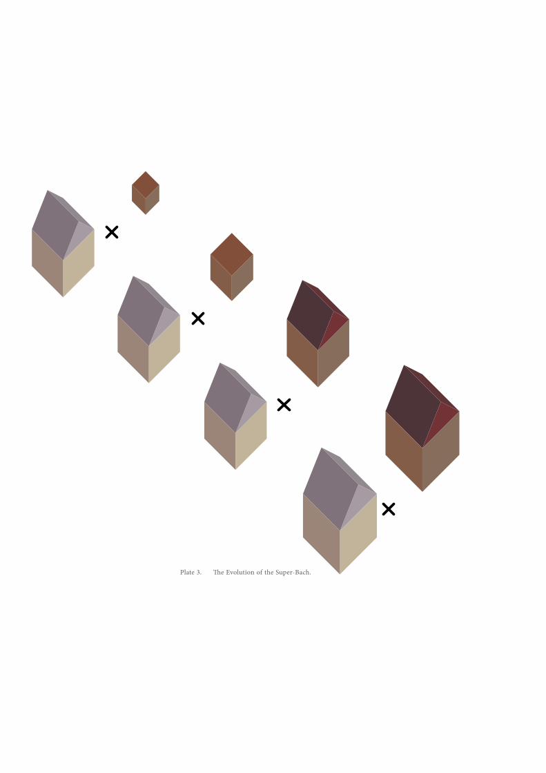
The first of these issues is the evolution of the ‘superbach’. The beginnings of the bach as a fringe construct manifested in its spatial qualities of being both small and an amalgamation of cheap and reused parts.
These architectural elements, such as corrugated iron and recycled timber, have influenced the vernacular for current coastal, and inland, developments. However, far from its beginnings as the cheap lean-to structure, bach has become sysnonymous with the luxury holiday home. Gone are the days where a bach would pale in comparison to the family home in terms of quality and refined comfort. The ‘superbach’ can be seen to stand beside the ‘superhouse’; where once the bach existed irrespective of economic hierarchy, it is now the domain of the upper middle class and beyond as a symbol of posterity. Plate 3.. Where once the bach could be seen as simply a shelter for an attempt to integrate oneself with the Ecological Landscape, they are seen less as a part of any particular landscape and more as platform from which to view it. The pressure to preserve view within any modern occupation is not a novel concept, but its prevalence
Plate 4. A sketch investigations into the staggering of views both horizontally and vertically.
55
is most definitely a result of the previously discussed relationship between landscape and nature. With the mindset of ‘more is more’, mentioned in the evolution of the ‘superbach’, the preservation of view as a feature is fought for. Landscape in its traditional understanding implies an element of framing the aesthetic and visible qualities of an area of land. Through this evolution, view has become a prestigious commodity traded lucratively in coastal real estate. This currency of view appears with no concern for framing any particular element of the surrounding environment. The increased need for density requires importance to be realigned with the framed view as opposed to the expansive view. In a context seemingly far removed from New Zealand’s coastal regions, precedent can be taken from the work of Japanese architects. Atelier Bow Wow, for example, make use of framed views to enhance the spatial and occupational qualities of the high-density living conditions typical of the urban areas of Tokyo. Examples of the way in which framing of views can affect the understanding of public and private space, as well as enhance the perception of ‘nature’ and open space. By utilizing these the advantages, the notion that high-density occupation affords no access to picturesque views and removes the occupant from that sense of ‘nature’ so esteemed in coastal culture can be challenged.
57
Before the standard methods of defining boundary and their effects infiltrated coastal culture, relaxed attitudes towards the mixing of public and private realms were a byproduct of inhabiting an undefined space. Kebbell identifies a underlying mentality of ‘drift’, so labeled by the Situationist thinker Guy Debord, leading to the understanding that “many of the habits and values at the bach correspond with both situationist and Creative Class views of urban life.”41 Indeed, this notion of ‘drift’ was prevalent, encompassing both mental and physical wandering;
“people drifted in and out of their own identities, days drifted from one to the next, interiors drifted outside, and sand drifted back in. People drifted between baches to sample the ambience.”42
As much as it can be said that post-colonial notions have altered the fundamental ideas of coastal culture, these fundamentals have not been lost in their entirety. Fused, it could be said that coastal culture no longer provides the total escape it once did. However, the tendencies of ‘drift’ can be seen as spatial manifestations in many of today’s coastal dwellings. Although our post-European relationship to the land can be observed in current baches and coastal developments, the more communal tendencies that define these spaces can be seen as a remnant of a more fluid ideology.
41 Kebbell, “Interiors in the Land of the Great Outdoors,” 5.42 Ibid., 4.
59
The favouring of these relaxed ideals over those of rigid definition has the potential to enhance higher density occupation by utilizing a variety of methods besides the traditional constructs to define space and movement. The discussion of the application of this principle can be found in The Design.
Density
Proposals for increased density are often met with much resistance, especially in sensitive and esteemed scenic locations. Though not the answer for every situation, in order to address New Zealand’s increasing population and immutable bach culture, defined areas of higher density development can provide the amenities needed. As a result of increasing the number of inhabitants within a circumscribed area, the potential to support commercial functions increases, leading to a concept that Planning editor Ruth Eckdish Knack calls ‘urban vitality’: “the cultural and commercial assets that only highly concentrated populations can produce and sustain.”43 The article discusses densities of a significantly greater magnitude, such as those of New York’s downtown neighbourhoods, but urban vitality has the potential to exist at much lower residential densities.
Even basic businesses, such as the dairy or Four Square require a certain local customer base in order to trade. 43 Ruth Eckdish Knack, “Dense, denser, denser still: perceptions can mislead when it comes to units per acre,” Planning 68, no. 8 (2002): 6.
61
These businesses that increase amenity to a community are a “function of density”44 and cannot be sustained below a certain density of local population. In effect, by achieving a level of density suited to a particular area, commercial enterprises can be sustained where these businesses in turn attract people to the community not only as residents but also as tourists. Agriculture, forestry and mining are the largest industries for Northland’s economy, but tourism contributes approximately 13% of the area’s GDP and is experiencing steady growth. Therefore, concentrated areas of increased density would enable the operation of small, commercial tourist industries to support Northland’s continued growth. The Design will address examples of neighbouring villages and their analysis to determine an appropriate level of density for the design proposal.
44 Ibid., 9.
63
The Ecological and Anthropological Landscapes, though inclusive of history, treat the passage of time as a chronological logic rather than a characteristic to be expressed. As a collection of memories and artifacts, the Archaeological Landscape addresses the remnants of the Anthropological in the context of the Ecological Landscape. Involving the physical vestiges of history, the Archaeological Landscape is concerned with both the acknowledgement of these objects as well as the ways in which they can be used to conjure memories and edify notions of place-making.
Heritage As An Identity
Once found, artifacts become entwined in a dialogue between the time that they reference and the time in which they are discovered. The ways in which this dialogue is encouraged is a matter of their contemporary expression and perception. The most blatant form of artifact presentation is that which takes precedence today – the presentation in a museum setting where relics are preserved, restored and objectified. This form of historical observation relies on the display of a collection of objects to narrate a story; a story that need not have played out in the location where they come to finally
65
be displayed. Though valid, the focus on the relic as a narrator of history produces a different outcome from the creation of environments where memories are induced and emotions triggered in order to engage with history.
While not degrading the integrity of the museum and the monument as historical interfaces, the spatial constructs they imply are experienced by the viewer in a manner more resembling tourism than through personal interpretation. In order to fully explore and understand a site’s Archaeological Landscape, artifacts and archaeological remains found within the site’s Ecological Landscape can be translated into architectural cues that enable history to be experienced through their spatial manifestation. These imaginative histories draw on individual memory and remembered experience as a crucial factor in place-making.
As explored earlier, many contemporary issues that affect site and its understanding are the result of recurrent attempts to protect the ideas of our past; the acceptance of an aesthetic history is the result of protecting intangible concepts whose effects can be validated through physical associations. The fabricated memories of our ancestors’ harmonious existence, and the convergence of nature and moral fortitude have resulted in tendencies that favour nostalgia. This proclivity for heritage characteristics is demonstrated through its widespread incorporation into marketed features of our Ecological Landscapes.
67
The use of these features to appeal to ‘old-world sensibilities’ is present across a scale of ventures: from the use of historical architectural elements throughout a community, to the use of vintage styling of new products to project a sense of superiority. The ‘quaint’ inn and the ‘rustic’ tavern play on the homely associations of a simpler life. Holiday destinations frequently call on the use of historic characteristics and traditional techniques, not to narrate a specific site history but to increase their marketability to a public entranced by the paraphernalia of history.
Vestiges of tradition are apparent in almost every aspect of contemporary existence. Unquestioned, they are repeated and reused as we unintentionally weave them through our lives in an effort to validate our identities. As if, should all the immediate context of our existence be called into question, the backing of tradition would reaffirm our existence; “However faithfully we preserve, however authentically we restore, however deeply we immerse ourselves in bygone times, life back then was based on ways of living incommensurable with our own.”45 Within literature, fables and fairytales remain unchanged through successive generations, unhindered by the continually expanding gap between the archaic and the contemporary.
45 David Lowenthal, The past is a foreign country (Cambridge [Cambridgeshire] ; New York: Cambridge University Press, 1985). xvi.
69
Ever retold, the worries eased and the plights expressed through their stories are (as Lowenthal45 said) incommensurable with the issues of today. The imagery of castles, carriages and armoured princes on horseback were once a commentary on relevant issues; in a time when there often existed a royal elite whose power translated into opulence, feudal battles were comparatively commonplace and the power of steam was as yet unfathomable. Yet it seems that these images are repeatedly rendered, and with each retelling becoming more whimsical in the eyes of present society. Though fairytales may seem far removed from any discussion regarding landscape, the reincarnation of history and the methods through which it is carried out are integral to our understanding of the Archaeological Landscape.
Sense Of Place: Idiosyncrasies And Compromise
The use of traditions - the conflation of history with the rituals of daily life - is a “lifestyle,” says Herrington, “formulating a sense of not only personal identity, but home and community.”46 In postmodern life “we get used to living with contradictions and there are several reasons for this: traditions crumble, and with them cultural identities.”47 In The Geography of Home, Akiko Busch records a number of contradictions and the way in which they are carried through from earlier periods in our history through a process of integration and adaptation.
46 Herrington, On landscapes: 38.47 Zumthor, Thinking architecture: 16.
71
These resolutions of inconsistencies are what let us define our sense of place. The argument is made then that traditional analytical display of artifacts, as they occur in museums, allows a chronological recount of history but through its failing to form emotional connections to a site, has no part in helping to define a sense of place or home. This failing is not indicative of an inability to
emotionally respond to the artifacts, the conflict caused by a collision between history and the present effects a personal interpretation. Hence, the interpretation of conflict through compromise is integral the definition of place. Like a museum’s objectified relics, monuments - the objectified markers of historical significance – show a historical feature without the interpretation or evocation necessary to impact on sense of place. The admiration of these objects as evidence of our origins reaffirms existence and provides the sense of being of a greater whole; as nature has often been seen as origins, the admiration of these objects as origins and hence “as nature imparts to others that you are connected to something greater, something that has not been purposefully framed for presentation to humans.”48
However, it is not only the inconsistencies between history and the contemporary that must be resolved. The Archaeological Landscape is the interpretation of a historical narrative in the context of an Ecological Landscape, and takes into account the human experience of this narrative. 48 Herrington, On landscapes: 50.
73
Hence, the role of individual memories and associations that affect the human experience is vital. In the act of place-making, differences between individuals must also be confronted. Arising from a unique collection of past experiences, situations and circumstances, every person has a different understanding of the factors that influence comfort. The anecdote related by Busch about a couple intending to build a house clearly illustrates how profoundly different expectations of ‘home’ can be. One wanted a place to withdraw - a cave-like atmosphere - while the other imagined an airy open space.49 When talking about principles of identity within a landscape, collective identity is often addressed yet there is a lack of appreciation for the vast differences between individual tastes. The fundamentals of ‘place’ are so widely varied, yet there is an expectation of a singular understanding. Through its expression on the geomorphological landscape, the Archaeological Landscape presents a narrative of a site’s history as a framework for individual interpretation and response; “Since our feeling and understanding are rooted in the past, our sensuous connections with a building must respect the process of remembering.”50
49 Akiko Busch, Geography of home : writings about where we live (New York: Princeton Architectural Press, 1999). 17.50 Zumthor, Thinking architecture: 18.
75
A Note On Recollections And Architectonics
The typology of development on a site is not the determinant factor of whether the contemporary sits in harmony with the past. The programme of any previous occupation does not affect subsequent interventions. The new proposal will likely exert demands that appear in opposition to any sense of harmony of the site. However, through this contradiction and the interpretation of artifacts, architectonic relationships are discovered. Although formal cues will likely be derived from the vernacular within the Anthropological Landscape, the investigation of found artifacts yields responses to architectural issues such as materiality. Through interrogation of these elements, the formal proposition is able to “embrace qualities that can enter into a meaningful dialogue with the existing situation.”51 This dialogue enables buildings to sit in what Zumthor calls a Completed Landscape where the intervention fits seamlessly into its surroundings.52 This concept does not equate simply to the use of formal heritage characteristics to appeal to a sense of nature and origins. The space, experiences and atmospheres embodies in a place should engage the human element over the course of its use. In Zumthor’s work, significant emphasis is placed on the specific use of materials to convey designed perceptions53. These perceptions stem from a personal dialogue between 51 Ibid., 17.52 Ibid.53 Ibid., 9-10.
77
the rational and the emotional: his formal architectural training, and his emotions and recollections of past experiences and atmospheres. The personal recollections of landscape architects have long been drawn upon to shape and inspire the scenes that they created.54
However, they have been used in significantly different methods. Historic landscape architects such as Frederick Law Olmstead (Central Park) simply used their memories in order to recreate a copy of the Ecological Landscapes they remembered. Zumthor, though referencing memory, relied on his repertoire of visceral reaction rather than direct reproduction. In order to elicit interpretation, an approach more aligned with latter must be undertaken so as to prevent the reproduction an aesthetic history.
54 Herrington, On landscapes: 35.
81
“When an architectural design draws solely from the tradition and only repeats the dictates of its site, I sense a lack of a genuine concern with the world and the emanations of contemporary life. If a work of architecture speaks only of contemporary trends and sophisticated visions without triggering vibrations in its place, this work is not anchored in its site, and I miss the specific gravity of the ground it
stands on.” 55
The theories discussed throughout Part One are offered as an insight to the concepts and points of view underlying this design proposal. Understanding that landscape is used in this text to represent its three constituent parts, this proposal seeks to share the site’s historical narrative through a design that sits as a part of its Completed Landscape. Through an analysis of site with regard to the presented theories, occurrences unique to this site have been interpreted into architectonic concepts that illustrate the way in which development of sensitive sites can be undertaken. Seeing that the desire to protect sensitive sites stems from a fear of forgetting, Herrington poses a vital question: “How can landscapes represent the past without using it to validate the present? How can historic artifacts be preserved, while allowing for present needs?” 56
55 Zumthor, Thinking architecture: 42.56 Herrington, On landscapes.
Whangarei
Marsden PointOil Refinery
Ruakaka
Urquharts Bay
Smugglers BaySite
Hen & ChickenIslands
Reotahi Bay
McLeod Bay
Munro Bay
Parua Bay
Whangarei Harbour
N
Plate 5. Context map, not to scale.
83
Herrington’s suggested response aligns with that of the proposed new paradigm that has been explored through these chapters - it involves paying homage to both current and historic issues through the interpretation of artifacts (The Archaeological Landscape) as well as expressing any previous use or occupation (The Anthropological Landscape) around concerns for the current ecological systems at play on the site (The Ecological Landscape). The fundamental acknowledgement of the role of the future is also identified.
Design Process
The Ecological Landscape15km South-East of Whangarei on Northland’s east coast, Smugglers Bay sits at the southern tip of Bream Head at the entrance to Whangarei Harbour. It sits in a temperate sub-tropical climate zone and receives around 1900 sunshine hours per year and an average rainfall of 1300mm. Though the prevailing winds are generally south-westerly, tropical cyclones in summer can bring heavy rainfall and nor-easterly winds57. Both a seaward-facing bay and a more sheltered coastal area facing Urquharts Bay are accessible on the site. The majority of Bream Head has been classed as an Outstanding Landscape and Department of Conservation (D.O.C)
57 “Living in Northland,” http://www.northlanddhb.org.nz/ careers/living-in-Northland/climate/
Plate 6. Context map indicating areas classed as OUtstanding Landscape (orange) and D.O.C. Conservation Land (grey).
Outstanding LandscapeD.O.C. Conservation Land
Site Area
85
Public Conservation Land, including the proposed site of Smugglers Bay. The extent of classification of the surrounding areas as Outstanding Landscape and D.O.C. Conservation Land can be seen in Plate 6.
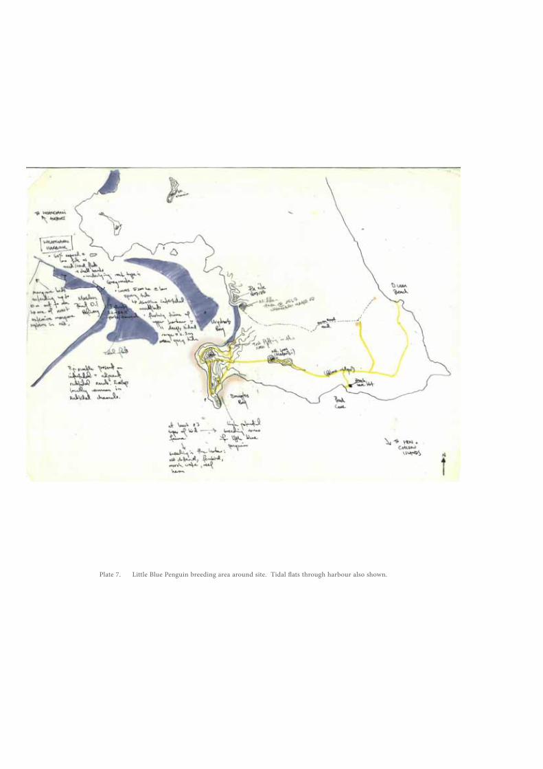
The majority of the headland area is steep, with a central section at a milder gradient. The bush regions to the steeper areas of the east and west of the site are covered in native coastal broadleaf forest with at least 380 plant types58. The coastal areas around Smugglers Bay are rich in sea-life, providing a wealth of bountiful fishing and diving locations. Within the harbour are several conservation initiatives for avifauna as well as marine ecologies. An example of birdlife protection areas can be seen in Plate 7. where breeding areas for the Little Blue Penguin (Eudyptula minor) follow the majority of the coastal perimeter of the site.
Within a 20km radius of the site, there are several landmarks and features including Mt. Manaia to the North and the Hen & Chicken Islands offshore to the West. Great Barrier Island lies further to the South.
58 Andrew Stone, “Bream Head: Walking On The Wild Side.” http://www.nzherald.co.nz/travel/news/article.cfm?c_ id=7&objectid=10703396
Plate 7. Little Blue Penguin breeding area around site. Tidal flats through harbour also shown.
87
The Anthropological LandscapeTo the North of Smugglers Bay in the area currently known as Urquharts Bay is an example of a previous Maori pa settlement. Artifacts indicate that this habitation occurred in either a single instance or a series of settlements some time between 1520 and 165059. Archaeological remains found in the vicinity provide evidence that the occupation at Smugglers Bay was more temporary in nature, likely used as a fishing encampment rather than a permanent settlement60. Investigations of both the pa area and other sites in Urquharts Bay enable an understanding of the spatial arrangements and relationships that once ordered the site; the presence of defensive ditches provide insight to the ideas of the open and the protected while other areas indicate the extent to which the earth was modified through terracing and agriculture.
British settlers had been settling New Zealand since approximately the 1840s. A large block of land under the name of Taurikura was originally purchased from 59 Caroline Phillips, “Further Artefact Analysis: Addendum to Archaeological Investigation, Midden Q07/571, 2567 Whangarei Heads Road, Urquharts Bay (Historic Places Authority 2007/25),” (Department of Conservation, 2010), 8.60 Matthew Campbell, “McCarthy property, Lot 2 DP 208170, Urquhart Bay: archaeological assessment,” (Department of Conservation, 2005), 3.
89
Maori landowners in 1839, after which it went through a series of subdivisions and reconfigurations presumable experiencing some form of low-scale occupation. The first houses in Urquharts Bay were erected from 1915 onwards61.
Due to its vantage point and clear sight of the harbor, gun emplacements were erected at Smugglers Bay during WWII but were unused in any combat situation. These structures are still in place and constitute a part of the walking trail attractions of Bream Head.
The Northland area is today largely sustained by an agricultural economy with over half of the land use in the region designated for pastoral agriculture and farming. Though seasonal, the tourism industry contributes significantly to the economy and is concentrated on the coastal and harbour areas as opposed to inland attractions62
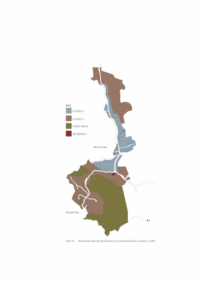
In order to best see how successful a denser level of development could exist on the site, a footprint area roughly equivalent to the current neighbouring 61 Phillips, “Further Artefact Analysis: Addendum to Archaeological Investigation, Midden Q07/571, 2567 Whangarei Heads Road, Urquharts Bay,” 8.62 Northland Regional Council, “Part I: Northland” New Regional Policy Statement, 17.
Urquharts Bay
Parua Bay
Plate 8. Urquharts Bay Residential Density Analysis. 1:2000
Plate 9. Parua Bay Residential & Commercial Density Analysis. 1:2000
N
N
McLeod Bay
LIVING 1KEY
LIVING 3
BUSINESS 3
OPEN SPACE
Reotahi Bay
Plate 10. McLeod/Reotahi Bay Residential & Commercial Density Analysis. 1:2000
N
LIVING 1LIVING 3OPEN SPACEBUSINESS 3
93
settlement of Urquharts Bay will be occupied. Within this area will be at least 120 houses and a commercial element as a part of the programme of the pier. These density of occupation was determined by analysing the composition of the neighbouring communities. This investigation assessed the approximate density of occupation necessary to support public amenities such as a community store. The are two levels of residential density zonings within these areas, and it can be seen that the higher density of occupation is generally found to be in closer proximity to the coast; this suggests that there is greater demand for ‘beach-side’ properties. The composition of the villages are as follows:
The Archaeological LandscapeThrough the recording of all artifacts and finds of archaeological importance, the country’s Anthropological Landscape is expressed. Such a diagram is compiled by the New Zealand Archaeological Association’s Archaeological Site Recording Scheme. This initiative aims document the archaeological discoveries throughout the country – the information mapped by the organization indicated the site’s richness of Anthropological Landscape through its density in archaeological discoveries. [A version of this mapped information can be found in the appendix.]
Much of the archaeological evidence on the site catalogues instances of occupation and provides insight to elements of daily life during the Maori phase of the site. Besides shell middens, a variety of stone artifacts were also found on the site. The interpretation of these archaeological fragments influenced a great deal of design considerations throughout the proposal. These stone artifacts were remnants of obsidian tools, with a small number of other stone types. These objects not only validated the existence of our forebears, they explored the connections they maintained with communities across the country; the sources of the obsidian artifacts reflected trade connections that the local tribes had with those in neighbouring areas as well as those significant distances away.
Plate 11. Diagrams representing test pit soil samples.
Plates 12. -17. Test pitting samples modelled in plaster, cardboard and foamboard.
Plates 18. - 20. Initial concept explorations of the layers discovered through test-pitting.
99
In addition to these artifacts, the archaeological processes undertaken on the site at present, should new structures or modifications to the Ecological Landscape be proposed, are reflected in conceptual approaches in the design process. Test pitting is required as an investigational tool in these areas proposed for modification. At the entrance to the site, a proposal for a small structure resulted in the excavation of several test pits. The visual representation of the information they embody is presented as Plates 11-20.Through a conceptual modeling of these layers, and the understanding that the cultural artifacts were found in the central stratum, the idea of ‘exposing the cultural layer’ evolved, Plate 21. The inherent qualities of a material, as discussed by Zumthor, are captured through these conceptual processes and carried through into decisions of materiality in the proposed design.
Although the areas of investigation that informed the design are ordered into the Ecological, Anthropological and Archaeological Landscapes, the process of design is more fluid in nature than this tripartite organization suggests. As such, a more chronological and train-of-thought design process is described in the following paragraphs.
The initial stages of the design process involved assigning function to the site – an element that would feasibly
Plate 21. Concept sketches of initial investigations of idea of ‘exposing the conceptual layer’.
101
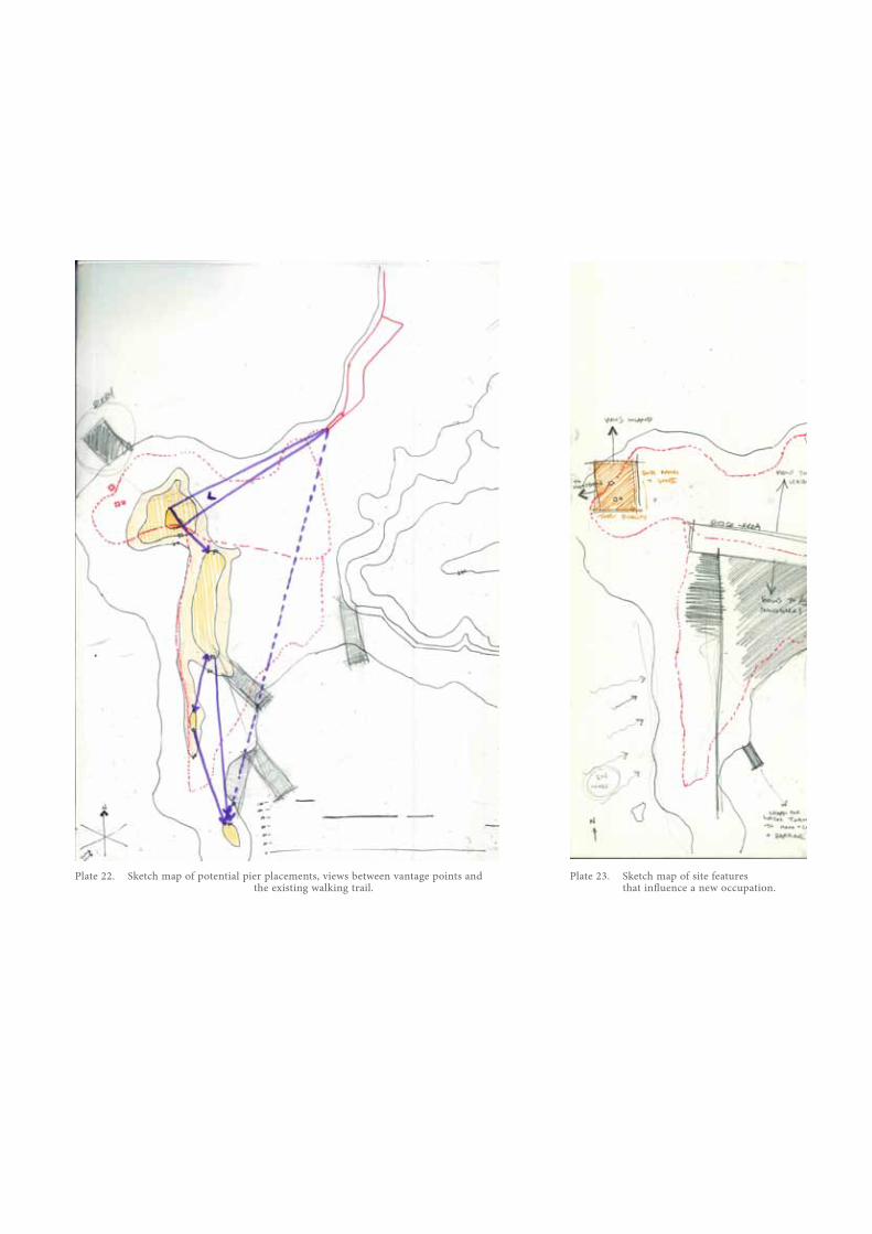
draw people to the new occupation. Potential functions drew on the types of activity indicated by archaeological evidence of the Anthropological Landscape, coupled with the presence of factors such as bountiful fishing areas and the contributions of marine farming63 to Northland’s economy as well as traditional agricultural methods. Possibilities for commercial elements included the operation of a self-sustaining market where traditional produce and kaimoana64 would be cultivated and harvested from the site and sold through a retail component. However, the pressures to maintain a supply level to meet the realistic demands of a retail operation would be impractical on the chosen site. As the proposal stands, the programme drawing people to the site focuses on the prominent location of the site at the mouth of the Whangarei Harbour. The introduction of a pier servicing both marine leisure activites and a potential ferry service would increase both the accessibility of the site as well as its appeal to locals and tourists. Initial ideas for the placement of the pier are illustrated in Plate 22. These orientations and locations are influenced by both the geomorphological landscape of the site as well the existing walking paths as mapped by the Department of Conservation. The final arrangement took into account the ocean depths and contours as shown on hydrographic charts. [See appendix for chart images.]63 Northland Regional Council, “Part I: Northland” New Regional Policy Statement, 17.64 Kaimoana is the Maori term for seafood.
Plate 22. Sketch map of potential pier placements, views between vantage points and the existing walking trail.
Plate 23. Sketch map of site features that influence a new occupation.
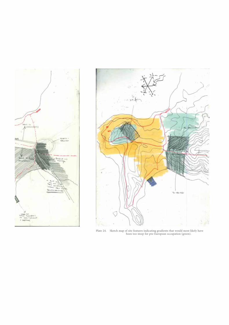
Plate 24. Sketch map of site features indicating gradients that would most likely have been too steep for pre-European occupation (green).
Plate 25. Conceptual arrangement explorations to maintain interior/exterior connections - the pinwheel plans.
105
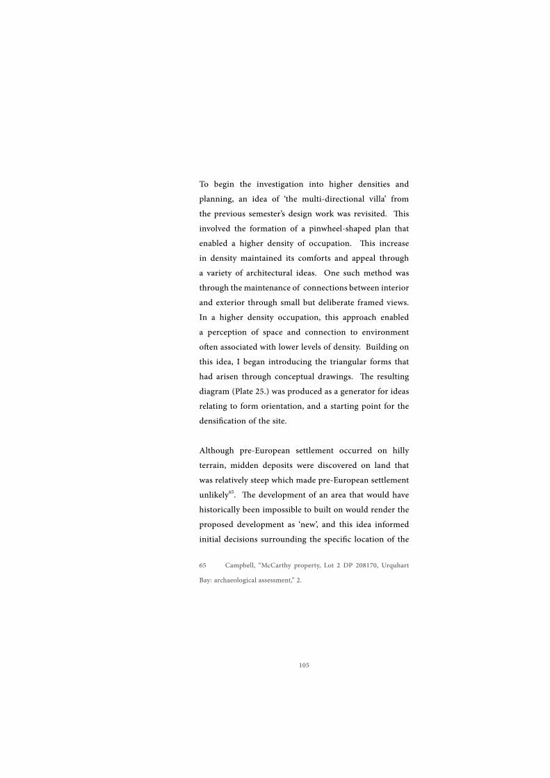
To begin the investigation into higher densities and planning, an idea of ‘the multi-directional villa’ from the previous semester’s design work was revisited. This involved the formation of a pinwheel-shaped plan that enabled a higher density of occupation. This increase in density maintained its comforts and appeal through a variety of architectural ideas. One such method was through the maintenance of connections between interior and exterior through small but deliberate framed views. In a higher density occupation, this approach enabled a perception of space and connection to environment often associated with lower levels of density. Building on this idea, I began introducing the triangular forms that had arisen through conceptual drawings. The resulting diagram (Plate 25.) was produced as a generator for ideas relating to form orientation, and a starting point for the densification of the site.
Although pre-European settlement occurred on hilly terrain, midden deposits were discovered on land that was relatively steep which made pre-European settlement unlikely65. The development of an area that would have historically been impossible to built on would render the proposed development as ‘new’, and this idea informed initial decisions surrounding the specific location of the
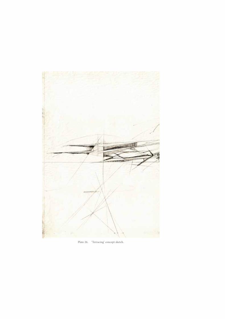
proposed development within the site. In many areas, the previous occupation of land by Maori is clear through the presence of terraces. References to this mode of remodeling the terrain would indicate the site’s previous habitation. A conceptual investigation exploring terracing is shown as Plate 26.
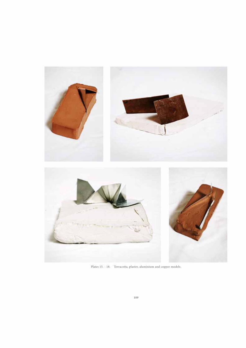
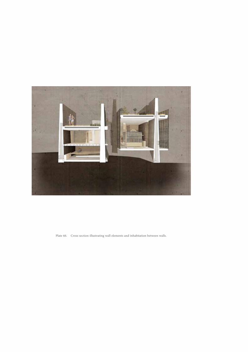
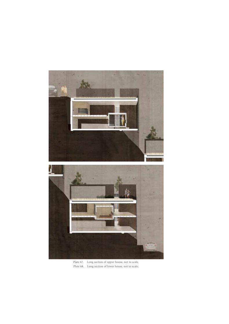
The sculptural qualities of the materiality informed by the artifacts and the resulting conceptual explorations became a central notion in informing the overall impact of the design as well as its more intimate details. This urge to present a sculpted response prompted an aesthetic often inspired by Richard Serra. A selection of conceptual models exploring both the cutting and excising of terrain and this sculptural materiality are shown through figs. 14-20. The clearest manifestation of these explorations is through the wall structures that project vertically from the ground. They can be seen as the drawing up, the exposing of the ‘cultural layers’ and the palimpsest that the development is inherently a part of. These walls are aligned to the landmark of Mount Manaia to the North. This acknowledges the importance of landforms and features in the identity of a place in Maori culture – the views to surrounding geographic locations has been diagrammatically represented in the final presentation panels (Plate. X). The perspectival arrangement of the statuesque wall elements also enables a response to the contemporary importance placed on ‘view’. The level of
Plate 27. Terracotta excavation models.
109
Plates 15. - 18. Terracotta, plaster, aluminium and copper models.
Plates 19. - 20. Paper and carboard models exploring the exposing of the cultural layer.
Plate 32. Paper model exploring the lifting of ground. Plate 33. Paper model exploring the lifting of ground.
Plate 34. Exploring the effects of framing view. Plate 35. Initial sketches of lifted and exposed planes & cuts.
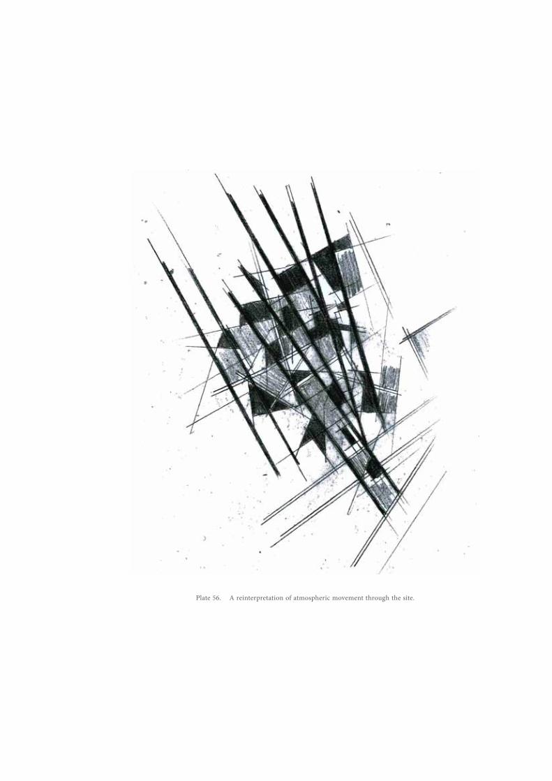
Plate 36. Conceptual plan of the site indicating paths established through atmospheric changes
113
density in the development discourages the use of vast, open expanses of glazing over the considered view (Plate 34.). By framing chosen elements of the environment as a whole, the perception of space and privacy is altered while enabling scenic views of significant landmarks.
The maintenance of public access, a significant concern to many who oppose development of sensitive areas, is also considered through the design. Boundary conditions throughout the site are less defined through traditional methods such as the fence. Differentiation between public and private spaces between dwellings utilize methods integrated into spatial arrangements and architectonic decisions. The heights and placement of fenestrations affect visual connections between inhabitants, and materiality cues are employed to portray changes in ownership. The ideas informing the movement through the development are informed by a sense of the Situationist’s ‘drift’ as previously emphasised by Kebbell. A conceptual plan-scape ise presented in Plate 36. By incorporating the elements of bach culture that are sought by inhabitants throughout the design, a comprehensive expression of these atmospheres becomes accessible. In this sense, movement throughout the development is practically unrestricted, and access to the coast from all areas of the site is unencumbered. A non-traditional treatment of road-level spaces is presented in in the images of final design work (Plate 72.) as a
Plate 37. An example of how the formal language of Pacific architecture was briefly referenced in early schemes.
Plate 38. Sheet of drawings showing early arrangements of space based on communal Maori buildings, such as the wharenui.
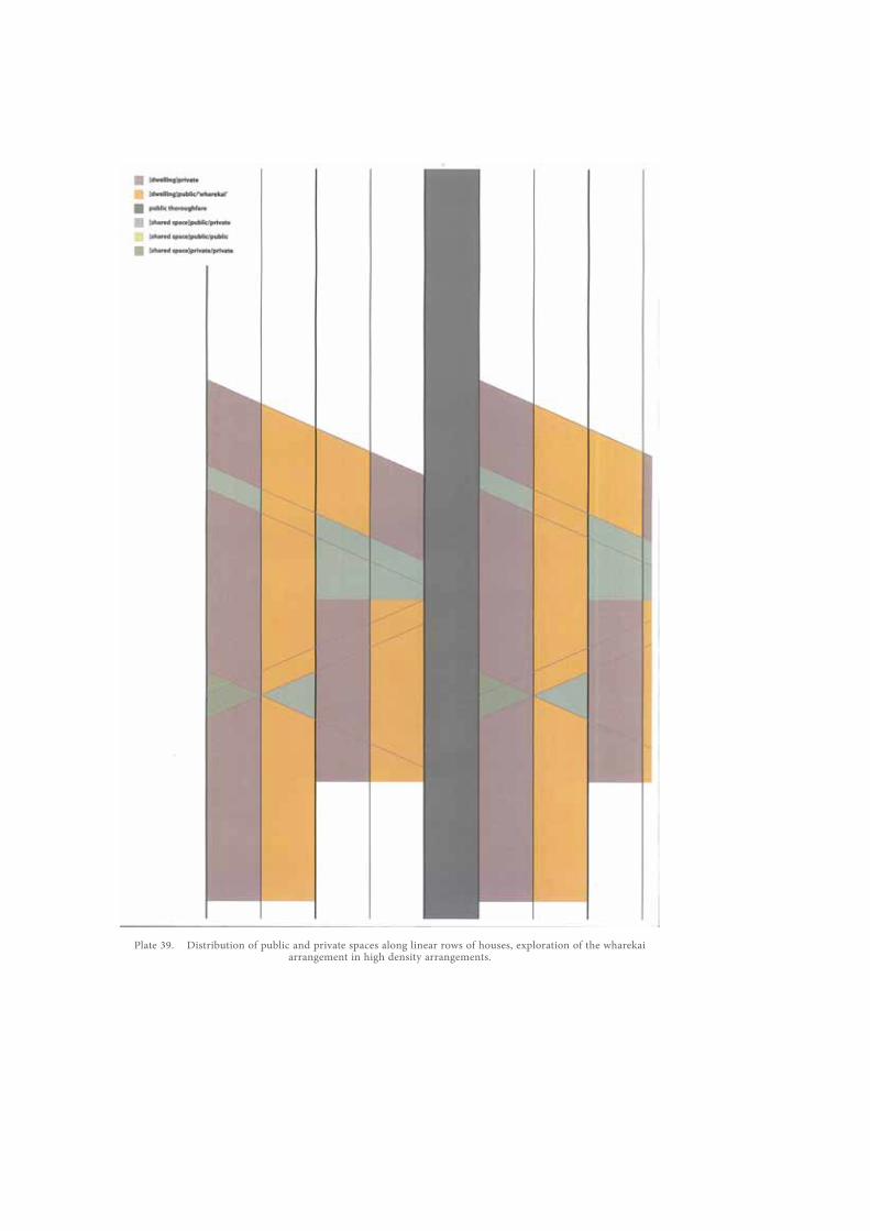
Plate 39. Distribution of public and private spaces along linear rows of houses, exploration of the wharekai arrangement in high density arrangements.
Plate 40. Programmatic cues from Pacific architecture are used to inform public/private spaces
throughout.
Plate 41. Fenestration placement to provide ‘hints’ of occupationPlate 42. Framing of views and the role of vertical elements in guiding view.
119
culmination of these ideas. The plans of the bach dwellings were informed by the communal properties of traditional Maori buildings such as the wharenui and the wharekai; the formal qualities of Pacific architecture here are largely ignored (after some reference to the roof-forms, Plate 37.) and their qualities of spatial organization are incorporated instead. The plans derived from these ideas worked largely around the use of open plan spaces, with changes in level re-representing the idea of the emergence of layers. The exploration of patterns of arrangement arising from the organizational qualities of these traditional buildings is attempted in Plate 39. & Plate 40.; the latter is a progression of the former and illustrates the general pattern of arrangement used to occupy the wall constructs.
The following reflections on drawings were written earlier in the design process, and convey the intent of the explorations presented through the associated figures:Within a dense development, both separation and connection between occupants is vital. Though private spaces are still desired, traditional ideas of separating walls can create spaces that do not address the level of human connection necessary. In order to maintain privacy, neighbours should not be able to always see directly into another occupied space, however it is possible to provide glimpses or signs of occupation through openings at floor-level or staggered openings.
Plate 43. Visual connections between public spaces of the dwellings.Plate 44. Layering of spaces.
121
The situation explored in Plate 41. describes how a passerby may be able to experience the presence of others within the community through an opening that allows direct eye contact between inhabitants as opposed to one that may allow elements, such as movement at floor level, to express inhabitation.
Plate 42. starts to investigate the framing of views and how glimpses of other occupation in the distance may affect the openness of view and freedom of sight. Additionally, the effects of certain openings that expose the connections and pathways between two buildings is explored, drawing forth the ideas seen in Plate 41.
(Plate 43.) By placing public areas of occupation, such as patio and deck areas together so that they are linked through visual connections as opposed to relying solely on physical proximity, cohesiveness throughout the dense development is possible. These visual linkages in turn enable secondary connections to external circulation pathways between buildings and through the community. They not only create a more open circulation route, they form another layer of programmatic definition (programme is not only indicated through materiality and form, but through the exposure of occupation methods) (Plate 44.) The loosening of density experientially relies on the inclusion of spaces that don’t fall in the traditional
Plate 45. Formation of alley spaces.Plate 46. The effect of vertical elements on view.
123
categories of interior and exterior. The layering of occupation through spaces that control view from and into enclosures and utilize a spectrum of spaces from exterior to interior enriches the qualities of space that may be limited by density requirements.
Often as a byproduct of density, access to and between houses manifests as an alley space; the circulation space is dwarfed by the exterior walls of buildings. This more typical alley space is explored in this image (Plate 45.) with openings places above eye-level to prevent direct visual connection between interior and exterior. The effects of narrowing the pathway and varying its level are also explored.
As a progression from the typical alley circulation, Plate 46. attempts to explore the spatial effects of strong vertical elements in directing the view of the user to a certain point as well as the effects of varying the level of the path in relation to floor levels of the neighbouring buildings.
(Plate 47.) View connections between houses and public areas of the dwellings. Framing view and the inclusion of built form and Ecological Landscape in the view.
The expression of vertical elements as opposed to horizontal elements acts to guide the inhabitants’ views towards specific elements as opposed to framing
Plate 47. View connections from within house. Inclusion of built form in the view.Plate 48. The merging of indoors and outdoors, terrain is sloped into the house.
125
Plate 49. Architectonic investigations.
A.
B.
C. D.
Plate 50. Continuation of triangulation and the redirection of views.
A.
B.
127
the traditional panoramic view often seen in coastal developments. These vertical elements also relate back to the ideas of slicing into the ground and excavation that were the initial motivators for the project. Plate 48. begins to show the integration of terrain with the constructed form and its modified levels. By linking spaces and level changes through terrain gradients softens the effects of potentially dramatic changes in level as well as providing access between these levels. This relates to the ideas relating to terracing
(Plate 49, A.) The setting of the roofline below eye-level from a public space or circulation pathway allows for habitation in addition to protection of certain views that enhance the experience of the site. By setting the inhabitation below the level of these public spaces it becomes possible to present these views to the occupants of the internal spaces allowing a visual connection to the outdoors and expanding the enclosure. If the view contains planted elements, for example, it appears as an extension of open space continuing into the house.
In the instance that circulation paths and spaces between residences are formed between tall vertical elements, several methods could be employed in order to maximize connections between both the peripheral spaces as well as between the individual interior spaces. The use of standard dimensions to denote public passageways, for example
129
1200mm, throughout both the external environment and within the dwellings presents a common language to the user throughout the development that inherently identifies the spaces perceived to be public and accessible. In the same manner, if planting strips of equal dimensions are placed both to the exterior and the interior aspects of the wall elements as seen on the left-side of Plate 49, B. a blurring of space and spatial ownership is achieved. This blurring of boundaries is essential to connect spaces within a dense development scheme and reflects ideas of New Zealand’s bach culture. Though it may be plausible to open certain areas up to public view in specific areas of the building, such as depicted in the right-hand side of Plate 49, B., the continuation of smaller dimensional elements such as the planting strips that remain legible through openings at floor-level are of significance when privacy needs to be maintained.
Methods of reconfiguring vertical partition elements will consequently affect the way in which spaces are perceived, for instance when they are closed off and blocking spaces as opposed to when they are opened up to allow connection. Once such duality is seen in Plate 49, C.and explores the possibility for creating a new space the reflects occupancy and accessibility. When the partition system is used to shade occupancy and provide privacy, a corridor-like space is apparent between the buildings. However, if occupants of both houses were
Plate 51. Redirection of views, northern aspect investigations.
131
to open their spaces, the partitions would act to create a sheltered walkway between the houses creating a semi-enclosed space that has different ownership properties than either of the individual spaces.
Elements of the design of the dwellings even at a smaller scale are pertinent in creating a space that is legible within the spectrum of privacy. The alignment of glazing in relation to the thickness of the wall provides ways in which to read the privacy of space as seen in Plate 49, D. The scenario on the far left describes the effect of placing the glazing through the center line of the wall’s thickness. The central diagram illustrates the recessed and ‘accessible’ effect of placing the glazing at the internal edge of the wall as opposed to the outer edge as seen in the scenario to the far right.
As a continuation from the triangular motifs seen in earlier diagrams, Plate 50, A. presents a formal exploration of an inhabitable element in the site, attempting to address the possibility of orienting views in directions perpendicular to the apparent axis of the building. This concept is continued in Plate 50, B. where the axis of the buildings, enclosed in their own volumes, are oriented both along and perpendicular to the contours of the slope and attempt to redirect views from their interiors perpendicular to these axes. This scenario is redressed in Plate 51. from the Northern view and attempts to see
133
how the built elements might act as mediators between different levels on terrain, cutting through the hillside as well as extending out into excavated and modified terrain elements.
These repetition of ideas from previous methods of living in a new mode of occupation make it is possible to inhabit a site while reflecting its history through the interpretations of the landscape in which it sits. The design reached as a convergence of the multitude of influences and factors informed by the landscape is presented in the following images.
In parallel to the investigation of more intimate and formal elements of the proposition, an overall site plan was also being designed. Through a series of site sketches and sketch maps that have been seen previously, a solution for the arrangement of higher density dwellings was sought.
The following images are a selection that were involved in the reiteration of ideas and development into the end scheme of the inhabitation of the distinct wall elements.
Initial concerns with density involved discerning the potentials and effects of ordering systems on the number of potential dwellings. By utilizing the method of ordering blocks on a site map, the effects of a rational
Plates . - . Investigating the impact of rigidity and ‘chaos’ on the potential achievable density
Plate 52. Investigating the impact of rigidity and ‘chaos’ on the potential achievable density
Plate 53. Investigating the impact of rigidity and ‘chaos’ on the potential achievable density
135
versus a chaotic system was observed both in plan, and to a degree, its effects on vertical aspects could be imagined (Plates 52. & 53.).
Continuing from these investigations, the sectional relationships on the extreme slopes of the site were investigated to reassess and reinterpret the products of the investigation. The resulting sectional investigation can be seen in Plate 54.
The results of the block layouts were traced back onto more analytical, layered site images such as shown in Plate 55.
Plate 56. could be seen as representing a stage in the planning process where the wall elements were manifesting as an idea - the straight visual elements are legible in many images throughout the stages of the design process. This image was a result of re-drawing and tracing Plate 36.
Plate 54. The tracing of the chaotic ordering of potential dwellings on site.Plate 55. The vertical relationships between masses on the hillside, an effort to gauge steepness.
Plate 56. A reinterpretation of atmospheric movement through the site.
139
Final Design & Presentation
The final design outcome embodying the research presented through this thesis is illustrated through the images to follow. Beginning with reduced copies of the final exhibition prints, the elements are subsequently discussed further. Images of the models that complete the body of presentation work are at the end of this section. Of the exhibition prints, the first roll describes the elements of the Ecological, Anthropological and Archaeological Landscapes that informed the final design response. The second roll presents the formal qualities of the proposition. The perspectival images follow and describe the atmospheric qualities and overall impact of the high density proposal.
Plate 57. Top half of first roll print. Not to scale.
Plate 58. Bottom half of first roll print. Not to scale.
Plate 59. Top half of second roll print. Not to scale.
Plate 60. Bottom half of second roll print. Not to scale.
Plate 61. Axes of view from the site to major local landmarks and neighbouring communities.Plate 62. Importance placed on the extensive view vs. the framed view.Plate 63. Midden and obsidian artifacts excavated in the area.Plate 64. The layers indicated by the test pitting process.Plate 65. Site plan indicating the walking trails that currently exist in addition to the WWII gunemplacement locations. Not to scale.
145
Plates 61-62. describe elements of the Anthropological Landscape. Although the view connections shown in Plate 61. also help to locate the site in a greater context of the Ecological Landscape,they were used to orient the built elements on the site. The significance placed by Maori on local landmarks as a form identity was of interest - rather than simply convey the site’s Maori history by orienting the development towards the Pa site, Mount Manaia was selected as this would have been a key reference to the community.
Plates 63. - 65. are representative of the Archaeological Landscape. Plate 63. documents the types of artifacts and archaeological evidence found on the site, while the location of the WWII gun emplacements on the walking trail are shown on Plate 65.
The site plan, as seen in Plate 59., is not reproduced here in regards to the feedback from the critique session (discussed in the following pages.) The proposal currently accomodates more than 150 dwellings across the site and demarcates the commercial zone where the pier would be placed. The current road that terminates at Urquharts Bay would be extended into the site, generally following the track currently walked by trampers. The location chosen
Plate 66. Cross section illustrating wall elements and inhabitation between walls.
147
for development is sheltered by the geomorphology of the site from the prevailing sou-westerly winds. The water depths in this area were also the most ideal for the placement of a ferry terminal/pier. Towards the summit is another commercial feature/public amenity. The lookout is placed there so as to enable the access to the views from the summit as well as maintaining tourist access.
The cross section (Plate 66.) illustrates the significant component for the design, the tapered walls that contain the services necessary in any domestic occupation. The services are accessed by hatches built into the walls at various points. The idea is that the walls will be placed on site first and can exist simply as walls. Individual baches are then built between these walls. The walls, representing the exposure of the landscape and its continuation upwards, could be seen to be a result of the initial conceptual models made from the test pitting information.
The long section illustrates how the slope of the hill is utilized in order to maintain visual connection through an intense development.
Plate 67. Long section of upper house, not to scale.Plate 68. Long section of lower house, not to scale.
Plate 69. Model indicating the development’s aesthetic and formal impact on the hillside.Plate 70. Sectional slice model showing one set of walls that orient to Mr. Manaia.
Plate 71. The view from a roof terrace uphill towards other dwellings. Glimpses of inhabitation are apparent.Plate 72. The proposed streetscape. The vertical elements constantly orient the viewer within the site.
151
Critique Reflection
The comments and discussion that arose from the critique provided valuable insight to potential ideas that could be expounded through continued research through design. The two main concerns presented offer valuable methods of enhancing the strength of the proposal. The first issue was the interest in what would be done with the physical artifacts once interpreted as a part of the landscape. Although the idea of presenting these as objects as history has been argued against through this research, methods of their incorporation must still be addressed. Their display as objects may be resisted, but it must also be remembered that they should not simply be destroyed or forgotten – their resorption into the landscape is necessary. It could be imagined that these objects be incorporated into architectural elements, especially the walls, as a part of the materiality much like an aggregate within concrete.
Secondly, the lack of reflection of palimpsest through the plan of the development was observed. The regularity of the overall plan conflicts with the idea of an expressed palimpsest. Variation in the intensity of elements appears to be key in progressing this aspect of the design, which has significant potential for improvement. The depth that the suggested changes would add to the experience of the site is great; it can be imagined that the dynamism added to the plan would induce changes of ‘pace’ throughout the development. This would be beneficial in exploiting the idea of ‘drift’, the constriction and relaxation of paths through the intesification and attenuation of density. Changes such as these would begin describe the plan more harmoniously with the concept. It is with regret that these changes could not be explored and presented here.
153
“We throw a stone into the water. Sand swirls up and settles again. The stir was necessary.
The stone has found its place. But the pond is no longer the same.”66
As an investigation of the layers comprising landscape, the three key elements elaborate on the human relationship with the environment. The ways in which a human inhabitation leaves its imprints is legible through the landscape. Though largely unconscious, the modification apparent through landscape demonstrates the relationships underwriting societies and hence, is important in understanding identity. Through the interpretation and subsequent expression of a site’s landscape, a relevant and contextual response is possible and enables contemporary occupations to sit as a harmonious element within a rich palimpsest.
By reflecting on the human relationship with nature, its connections with our origins and morality become apparent. The clarification of these relationships enables a relevant response to the perceptions of supposed ‘natural landscapes’ and interrogates the viewpoints of outright protection and preservation that oppose continued evolution.
66 Zumthor, Thinking architecture: 18.
155
The proposed ideas for a continued progression of occupation do not disregard antecedent ideologies to current issues, but reflect on them in order to arrive at a new definition for our relationship with nature in the current context. This involves taking into consideration the fears that initiate the compulsive preservation of the Ecological Landscape. Indicative of the current thinking, these issues such as ecological conservation must be considered in the proposed strategy for future developments. In this proposition, the importance of conservation issues is addressed by limiting the total footprint area and condensing occupation so as to maintain significant proportions of unbuilt environment. This reduces sprawl to preserve surrounding ecological systems and lessens the disruption of the Archaeological Landscape.
Through social constructs and cultural ideologies, the human relationship with the Ecological Landscape shapes the ways in which the issues related to inhabitation are addressed. The current proliferation of sprawl is seen largely as a vestige of colonial views of land as a commodity. Despite the irrelevancy of these concepts to the current issues of society, they are incessantly reiterated. Through investigation of alternative cultural relationships, a contemporary set of values that affect boundary-making and spatial arrangement are materialized. To address the architectonic issues of density, the values derived from
157
a consolidation of Maori, Colonial and bach culture responses to space, an effective density of occupation relevant to the site is determined and developed. The weaving of these characteristics together to inform design decisions results in spatial constructs that respect the previous occupations on the site and assist in invoking the genius of the site.
Weary of creating a touristic development through the monumental display of objects, an interplay between the rational and the emotional – material and atmosphere – is necessary to complete a sensitive response to landscape. Investigation of archaeological elements found on the site were used to inform the framework of atmospheres and elements used to narrate its history. Although a significant number of artifacts have been found on or in the vicinity of the site, the display of these remnants as objects becomes less relevant than the ways in which they are used to inform a sense of place. As a result, the juxtaposition between an overbearing historical narrative and the rituals of contemporary existence that take place within the proposed development are resolved. The idiosyncrasy between a collective history and an individual life exist simultaneously.
160
Atorie Wan. Atelier Bow-Wow : Echo of Space, Space of Echo [in Parallel title and text in Japanese and English.]. Contemporary Architect’s Concept Series. Tokyo: INAX, 2009.
Barr, Cathryn. “Test Excavations - Bream Head Scenic Reserve.” Department of Conservation, 2001.Bastéa, Eleni. Memory and Architecture. Albuquerque: University of New Mexico Press, 2004.Bedell, Geraldine. The Handmade House : A Love Story Set in Concrete. London: Viking, 2005.Board, Northland District Health. “Living in Northland.” http://www.northlanddhb.org.nz/careers/living-in-
Northland/climate/.Busch, Akiko. Geography of Home : Writings About Where We Live. New York: Princeton Architectural Press, 1999.———. The Uncommon Life of Common Objects : Essays on Design and the Everyday. 1st ed. New York: Metropolis
Books, 2005.Byrd, Warren T., Todd W. Bressi, and Seaside Institute. The Seaside Debates : A Critique of the New Urbanism. New
York: Rizzoli, 2002.Campbell, Matthew. “Mccarthy Property, Lot 2 Dp 208170, Urquhart Bay: Archaeological Assessment.” Department
of Conservation, 2005.Claval, Paul, and John A. Agnew. Landscapes, Identities, and Development. Farnham, Surrey ; Burlington, VT:
Ashgate, 2011.Congress, The Library of. “Today in History: April 26.” memory.loc.gov/ammem/today/apr26.html.Council, Northland Regional. “Biodiversity and Ecosystems.” In New Regional Policy Statement - Background
Documents: Northland Regional Council.———. “Environment.” http://www.nrc.govt.nz/Environment/Coast/Our-coast/Facts-about-coast/.———. “Infrastructure.”———. “Introduction.” In Regional Policy Statement: Northland Regional Council, 1999.———. “Our Coast.” In New Regional Policy Statement - Background Documents: Northland Regional Council.———. “Outstanding Natural Features and Landscapes.” In New Regional Policy Statement - Background Documents:
Northland Regional Council.———. “Part I: Northland.” In Regional Policy Statement: Northland Regional Council, 1999.———. “Part Ii: Legislative Framework and Structure.” In Regional Policy Statement: Northland Regional Council,
1999.———. “Part Iii: Resource Management Process Policy.” In Regional Policy Statement: Northland Regional Council,
1999.———. “Part Iv: Resource Policy.” In Regional Policy Statement: Northland Regional Council, 1999.———. “Tangata Whenua.” In New Regional Policy Statement - Background Documents: Northland Regional
Council.
161
Dowding, J.E. “Potential Impacts on Shorebirds of a Proposed Subdivision at Te Arai, North Auckland.” DM Consultants, 2006.
Duncan, James S., and Nancy Duncan. Landscapes of Privilege : The Politics of the Aesthetic in an American Suburb. New York: Routledge, 2004.
Herrington, Susan. On Landscapes. Thinking in Action. New York: Routledge, 2009.Jackson, John Brinckerhoff. Discovering the Vernacular Landscape. New Haven: Yale University Press, 1984.Juel-Christiansen, Carsten, and Gilbert Hansen. Transitions : Space in the Dispersed City. Copenhagen, Denmark:
Arkiteturtidsskrift B/Architectural Magazine B, 2000.Kebbell, Sam. “Interiors in the Land of the Great Outdoors.” In IDEA (Interior Design Educators of Australasia)
Inside-Out. Domain House, Melbourne, 2005.———. “Small Steps to Paradise.” Houses Magazine, 2010.———. “Untitled, 2008.” In On Adam’s House in the Pacific: Symposium in Honour of Joseph Rykwert, 16. Conference
Center, University of Auckland, 2008.Kingi, Tanira. “Maori Landownership and Land Management in New Zealand.” edited by Australian Agency for
International Development, 2008.Knack, Ruth Eckdish. “Dense, Denser, Denser Still: Perceptions Can Mislead When It Comes to Units Per Acre.”
Planning 68, no. 8 (August 2002 2002).Knight, Alan. “”Why Does Modernism Refuse to Die” Towards a Post Compositional Architecture.” In ACSA
Northeast Regional Meeting, 135-41. McGill University, Montreal, 2002.La Hood, Grant. “Help Save Te Arai.” http://www.savetearai.co.nz/.Lowenthal, David. The Past Is a Foreign Country. Cambridge [Cambridgeshire] ; New York: Cambridge University
Press, 1985.McAloon, Jim. “Land Ownership - MƗori and Land Ownership.” In Te Ara - the Encyclopedia of New Zealand,
edited. http://www.TeAra.govt.nz/en/land-ownership/1.McKay, Bill and Antonia Walmsley. “Maori Time: Notions of Space, Time and Building Form in the South Pacific.”
In.Museum, Waipu. “The Great Migration.” Waipu Museum, http://www.waipumuseum.com/html/migration.htm.Neis, Hajo. “Modernism Is Going Away as Urbanism but Not as Architecture.” In ACSA Northeast Regional Meeting,
150-56. McGill University, Montreal, 2002.
162
Park, Geoff. Theatre Country : Essays on Landscape & Whenua. Wellington, N.Z.: Victoria University Press, 2006.Phillips, Caroline. “Damage Assessment of Midden Site (Q07/751) 2567 Whangarei Heads Road, Urquharts Bay.”
Department of Conservation, 2006.———. “Discovery of Koiwi, at Urquharts Bay, Whangarei Heads (Interim Report).” Department of Conservation,
Heads Road, Urquharts Bay (Historic Places Authority 2007/25).” Department of Conservation, 2010.Phillips, Caroline and Brent Druskovich. “Archaeological Investigation, Midden Q07/571, 2567 Whangarei Heads
Road, Urquharts Bay: Historic Places Authority 2007/25.” Department of Conservation, 2009.Stevenson, Angus, and Lesley Brown. Shorter Oxford English Dictionary on Historical Principles. 6th ed. 2 vols Oxford
; New York: Oxford University Press, 2007.Stone, Andrew. “Bream Head: Walking on the Wild Side.” In, New Zealand Herald (2011). Published electronically
February 5, 2011. www.nzherald.co.nz/travel/news/article.cfm?cid=7&objectid=10703396.Thorne, Dylan. “Te Arai: We Don’t Want Orewa Ii.” In, The Northern Advocate (2006). Published electronically April
27, 2006. http://www.northernadvocate.co.nz/news/te-arai-we-dont-want-orewa-ll/960478/.Wortham, B.D. “Modernity and Urbanism Revisited: Baudelaire and the Boulevard.” In ACSA Northeast Regional