Introduction India is a country with outstanding, remarkable and rich geo-wealth. India has about 2.1% of the Earth’s land surface area and about 8% of the world’s biodiversity. The country is rich with unparalleled geo-wealth and geodiversity due to – (a) large variety of rocks representing almost the entire spectrum of the geological timescale (>3.0 Gyr to Holocene), (b) the Indian Shield, a repository of economically valuable minerals, made up of a number of Precambrian cratonic blocks, fold belts and rifts, and characterised by some of the oldest land surfaces in the world, (c) the Himalaya Mountains, the highest, youngest and tectonically most active mountain belt in a collisional setting, (d) the vast alluvial landscape of the Indus-Ganga-Brahmaputra Rivers occupying a large geological and sedimentary depression, (e) the Western Ghat (Sahyadri), the great escarpment of India associated with the western passive margin, (f) the Deccan Traps, a large igneous province, (g) nearly 7,500 km long coastline, Journal of Indian Geomorphology Volume 3, 2015 ISSN 2320-0731 Indian Institute of Geomorphologists (IGI) Fourth Prof S.R. Basu Memorial Lecture, 2015, delivered at the 27th National Conference of the Indian Institute of Geomorphologists (IGI) organised by the Vidyasagar University at Digha, during 14–17 November 2014 Vishwas S. Kale Department of Geography, S P Pune University, Pune-411007 E-mail: [email protected]Abstract: India is a country with rich geo-wealth and geoheritage. Geo-wealth refers to all the abiotic elements (geological, geomorphological, hydrological, and pedological) of the landscape. Geological and geomorphological features occurring in different parts of the country are part of the natural assets and are precious national heritage (geoheritage), worthy of conservation. Apart from rock monuments and fossil parks, geomorphological wonders or geomorphosites have great potential to attract tourists. Such sites are also significant from the point of view of geoscience education and research. Geotourism with a focus on landscape and geology is growing rapidly all over the world and India is no exception to this. To promote geotourism in India, comprehensive information (geoinfographics) about geomorphosites should be made available to the tourists by way of websites. For this, first a peer-reviewed national inventory of geomorphosites and their classification, mapping and assessment is required. In this paper, a simple 10-digit geocoding system for four dozen potential geomorphosites in India is suggested. This coding could be used to establish a classification and the priority of geomorphosites. It is obvious that serious efforts are needed to protect the national geomorphological wonders for posterity. 10 JOURNAL OF INDIAN GEOMORPHOLOGY: VOLUME 3, 2015
Transcript
IntroductionIndia is a country with outstanding,
remarkable and rich geo-wealth. India hasabout 2.1% of the Earth’s land surface areaand about 8% of the world’s biodiversity. Thecountry is rich with unparalleled geo-wealthand geodiversity due to – (a) large variety ofrocks representing almost the entire spectrumof the geological timescale (>3.0 Gyr toHolocene), (b) the Indian Shield, a repositoryof economically valuable minerals, made upof a number of Precambrian cratonic blocks,
fold belts and rifts, and characterised by someof the oldest land surfaces in the world, (c) theHimalaya Mountains, the highest, youngestand tectonically most active mountain belt ina collisional setting, (d) the vast alluviallandscape of the Indus-Ganga-BrahmaputraRivers occupying a large geological andsedimentary depression, (e) the Western Ghat(Sahyadri), the great escarpment of Indiaassociated with the western passive margin,(f) the Deccan Traps, a large igneousprovince, (g) nearly 7,500 km long coastline,
Journal of Indian GeomorphologyVolume 3, 2015 ISSN 2320-0731Indian Institute of Geomorphologists (IGI)
Fourth Prof S.R. Basu Memorial Lecture, 2015, delivered at the 27th National Conference of the Indian Instituteof Geomorphologists (IGI) organised by the Vidyasagar University at Digha, during 14–17 November 2014
Vishwas S. KaleDepartment of Geography, S P Pune University, Pune-411007
Abstract: India is a country with rich geo-wealth and geoheritage. Geo-wealth refers toall the abiotic elements (geological, geomorphological, hydrological, and pedological) ofthe landscape. Geological and geomorphological features occurring in different parts ofthe country are part of the natural assets and are precious national heritage (geoheritage),worthy of conservation. Apart from rock monuments and fossil parks, geomorphologicalwonders or geomorphosites have great potential to attract tourists. Such sites are alsosignificant from the point of view of geoscience education and research. Geotourism witha focus on landscape and geology is growing rapidly all over the world and India is noexception to this. To promote geotourism in India, comprehensive information (geoinfographics) about geomorphosites should be made available to the tourists by wayof websites. For this, first a peer-reviewed national inventory of geomorphosites and theirclassification, mapping and assessment is required. In this paper, a simple 10-digit geocoding system for four dozen potential geomorphosites in India is suggested. Thiscoding could be used to establish a classification and the priority of geomorphosites. It isobvious that serious efforts are needed to protect the national geomorphological wondersfor posterity.
10 JOURNAL OF INDIAN GEOMORPHOLOGY: VOLUME 3, 2015
(h) the monsoon climate, (i) variety ofgeomorphic processes (e.g. hillslope, fluvial,coastal, aeolian, glacial, etc.), and (j) presenceof all the major ecosystems of the world.
Geo-wealth is a descriptive term that refersto all the abiotic elements (geological,geomorphological, hydrological, andpedological) of the landscape. As this geo-wealth has been transmitted or inherited fromthe past, it is described as geoheritage (Brocxand Semeniuk, 2007). Geoheritage may befurther classified as geological heritage andgeomorphological heritage (Fig. 1). Theformer deals with the geological features(rocks, minerals, fossils, folds, faults, etc.),and the latter refers to the geomorphologicalfeatures and elements (landforms, landscapes,drainage network and soils).Geomorphological heritage includes sites or acollection of sites, called geomorphologicalsites or geomorphosites, which aregeomorphological landforms or landscapes“that have acquired a great scientific, cultural/historical, aesthetic and/or social/economic
value due to human perception orexploitation” (Panizza, 2001). Greater is thenumber of physical elements in an area, thegreater is the geomorphic diversity orgeomorphodiversity (Panizza, 2009; Pellitero,et al., 2011)
India’s World Heritage Sites and NationalGeological Monuments
Geotourism is defined as “a form of naturetourism that specifically focuses on landscapeand geology” (Dowling, 2011). The subject ofgeotourism is growing rapidly all over theworld, and India is no exception to this. Whilehistorical monuments, archaeological sitesand ancient temples are major drivers oftourism in India, attracting millions of touristsevery year, the number of tourists visitingnational parks (Nanda Devi, Kaziranga,Sundarbans, Manas, Kanha, etc.), biospherereserves (Nilgiri, Mannar, Similipal, Nokrek,Pachmarhi, Kanchanjanga, Dehang Debang,Dibru-Saikhowa, etc.), Ramsar sites (Wular,Lokta, Chilka, Sambhar, Vembanad), as well
11
Geo-wealthGeoheritage
Geosites GeomorphositesGeoparks Geomorphoparks
GeologicalHeritage
Rocks, Minerals, Fossils, Faults,etc.
GeomorphologicalHeritage
Landforms, Landscapes, Hydrology, Soils
Figure 1. Classification of geo-wealth (geoheritage)
as geoheritage sites (Ladakh, Lonar Crater,Jog Falls, Varkala Beach, Mawsmai Cave,Borra Cave, Mt. Abu, Araku Valley, Nilgiri,Mahabaleshwar, etc.) is steadily increasing.
Places that provide best examples of the
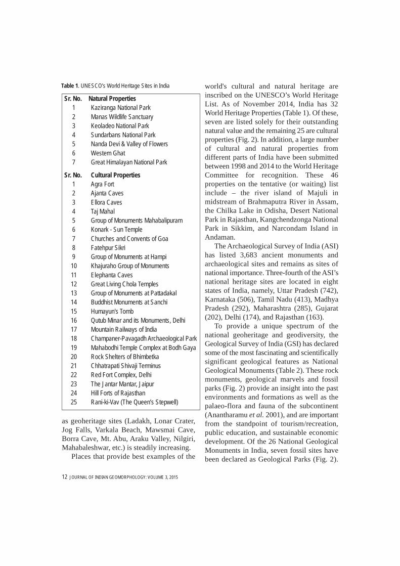
world's cultural and natural heritage areinscribed on the UNESCO’s World HeritageList. As of November 2014, India has 32World Heritage Properties (Table 1). Of these,seven are listed solely for their outstandingnatural value and the remaining 25 are culturalproperties (Fig. 2). In addition, a large numberof cultural and natural properties fromdifferent parts of India have been submittedbetween 1998 and 2014 to the World HeritageCommittee for recognition. These 46properties on the tentative (or waiting) listinclude – the river island of Majuli inmidstream of Brahmaputra River in Assam,the Chilka Lake in Odisha, Desert NationalPark in Rajasthan, Kangchendzonga NationalPark in Sikkim, and Narcondam Island inAndaman.
The Archaeological Survey of India (ASI)has listed 3,683 ancient monuments andarchaeological sites and remains as sites ofnational importance. Three-fourth of the ASI’snational heritage sites are located in eightstates of India, namely, Uttar Pradesh (742),Karnataka (506), Tamil Nadu (413), MadhyaPradesh (292), Maharashtra (285), Gujarat(202), Delhi (174), and Rajasthan (163).
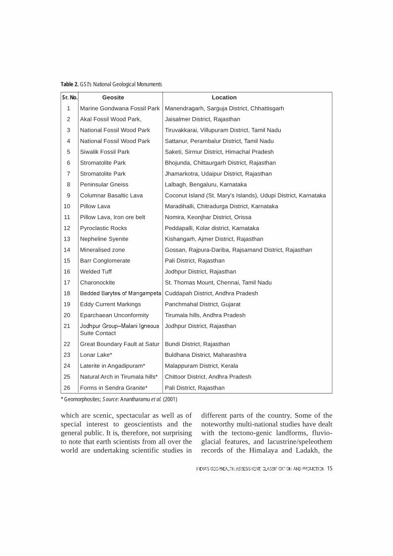
To provide a unique spectrum of thenational geoheritage and geodiversity, theGeological Survey of India (GSI) has declaredsome of the most fascinating and scientificallysignificant geological features as NationalGeological Monuments (Table 2). These rockmonuments, geological marvels and fossilparks (Fig. 2) provide an insight into the pastenvironments and formations as well as thepalaeo-flora and fauna of the subcontinent(Anantharamu et al. 2001), and are importantfrom the standpoint of tourism/recreation,public education, and sustainable economicdevelopment. Of the 26 National GeologicalMonuments in India, seven fossil sites havebeen declared as Geological Parks (Fig. 2).
Sr. No. Natural Properties1 Kaziranga National Park 2 Manas Wildlife Sanctuary3 Keoladeo National Park4 Sundarbans National Park 5 Nanda Devi & Valley of Flowers6 Western Ghat7 Great Himalayan National Park
Sr. No. Cultural Properties1 Agra Fort2 Ajanta Caves3 Ellora Caves4 Taj Mahal 5 Group of Monuments Mahabalipuram6 Konark - Sun Temple7 Churches and Convents of Goa8 Fatehpur Sikri9 Group of Monuments at Hampi10 Khajuraho Group of Monuments11 Elephanta Caves12 Great Living Chola Temples13 Group of Monuments at Pattadakal14 Buddhist Monuments at Sanchi15 Humayun's Tomb16 Qutub Minar and its Monuments, Delhi17 Mountain Railways of India18 Champaner-Pavagadh Archaeological Park19 Mahabodhi Temple Complex at Bodh Gaya20 Rock Shelters of Bhimbetka21 Chhatrapati Shivaji Terminus22 Red Fort Complex, Delhi23 The Jantar Mantar, Jaipur24 Hill Forts of Rajasthan25 Rani-ki-Vav (The Queen’s Stepwell)
Table 1. UNESCO’s World Heritage Sites in India
12 JOURNAL OF INDIAN GEOMORPHOLOGY: VOLUME 3, 2015
Majority of the GSI’s monuments areconcentrated in Rajasthan (10) and threesouthern states, viz. Karnataka (4), Andhra(3), and Tamil Nadu (3).
Geomorphological heritage sites in India In addition to the geological monuments
and fossil parks, general public is alsoattracted to natural or “geomorphologicalwonders”. These geomorphological wonders
are in fact distinctive or outstandinglandforms, such as waterfalls, pothole-studded channels, gorges, canyons, beaches,natural arches, mesas, plateaux, escarpments,badlands, alluvial fans and cones, terraces,inselbergs/bornhardts, sand dunes, karst caveswith stalactites and stalagmites, etc.Scientifically and educationally significantgeomorphological heritage sites include thosewith text-book features and landscapes. A few
13
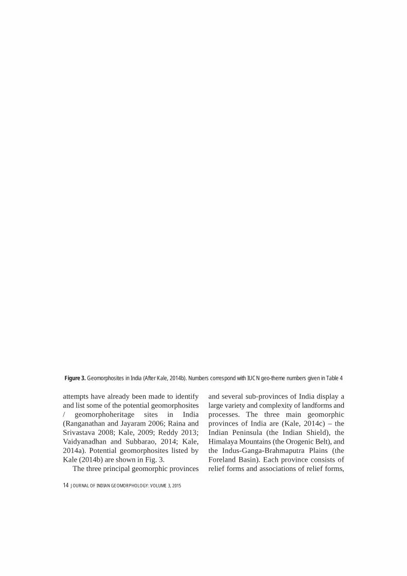
attempts have already been made to identifyand list some of the potential geomorphosites/ geomorphoheritage sites in India(Ranganathan and Jayaram 2006; Raina andSrivastava 2008; Kale, 2009; Reddy 2013;Vaidyanadhan and Subbarao, 2014; Kale,2014a). Potential geomorphosites listed byKale (2014b) are shown in Fig. 3.
The three principal geomorphic provinces
and several sub-provinces of India display alarge variety and complexity of landforms andprocesses. The three main geomorphicprovinces of India are (Kale, 2014c) – theIndian Peninsula (the Indian Shield), theHimalaya Mountains (the Orogenic Belt), andthe Indus-Ganga-Brahmaputra Plains (theForeland Basin). Each province consists ofrelief forms and associations of relief forms,
Figure 3. Geomorphosites in India (After Kale, 2014b). Numbers correspond with IUCN geo-theme numbers given in Table 4
14 JOURNAL OF INDIAN GEOMORPHOLOGY: VOLUME 3, 2015
which are scenic, spectacular as well as ofspecial interest to geoscientists and thegeneral public. It is, therefore, not surprisingto note that earth scientists from all over theworld are undertaking scientific studies in
different parts of the country. Some of thenoteworthy multi-national studies have dealtwith the tectono-genic landforms, fluvio-glacial features, and lacustrine/speleothemrecords of the Himalaya and Ladakh, the
Table 2. GSI’s National Geological Monuments
Sr. No. Geosite Location
1 Marine Gondwana Fossil Park Manendragarh, Sarguja District, Chhattisgarh
2 Akal Fossil Wood Park, Jaisalmer District, Rajasthan
3 National Fossil Wood Park Tiruvakkarai, Villupuram District, Tamil Nadu
4 National Fossil Wood Park Sattanur, Perambalur District, Tamil Nadu
5 Siwalik Fossil Park Saketi, Sirmur District, Himachal Pradesh
6 Stromatolite Park Bhojunda, Chittaurgarh District, Rajasthan
7 Stromatolite Park Jhamarkotra, Udaipur District, Rajasthan
14 Mineralised zone Gossan, Rajpura-Dariba, Rajsamand District, Rajasthan
15 Barr Conglomerate Pali District, Rajasthan
16 Welded Tuff Jodhpur District, Rajasthan
17 Charonockite St. Thomas Mount, Chennai, Tamil Nadu
18 Cuddapah District, Andhra Pradesh
19 Eddy Current Markings Panchmahal District, Gujarat
20 Eparchaean Unconformity Tirumala hills, Andhra Pradesh
21 Jodhpur District, RajasthanSuite Contact
22 Great Boundary Fault at Satur Bundi District, Rajasthan
23 Lonar Lake* Buldhana District, Maharashtra
24 Laterite in Angadipuram* Malappuram District, Kerala
25 Natural Arch in Tirumala hills* Chittoor District, Andhra Pradesh
26 Forms in Sendra Granite* Pali District, Rajasthan
* Geomorphosites; Source: Anantharamu et al. (2001)
15
lakes/playas and sand dunes of the TharDesert, the Kosi megafan, the braided channelof the Brahmaputra River (India andBangladesh), the granitic and the duricrustedlandforms of the Peninsular India, the WesternGhat Escarpment, and the Ganga-Brahmaputra Delta.
(a) The Indian peninsulaThe Indian Peninsula has high potential for
geoscientific studies as well as geotourism.The triangular-shaped peninsula is the oldestand the largest geomorphic province of India,and is made up of Archaean rocks andProterozoic fold belts. This fragment of theGondwanaland largely displays an erosionallandscape, which is not only visuallyappealing but also scientifically important.The Peninsular landscape displays manyfeatures inherited from the past (Cenozoic).By and large, bedrock landforms, rockychannels and partially to deeply weatheredrocks dominate the scenery of this ancientlandmass.
The Peninsula has both specificgeomorphosites of local and regionalsignificance and key geomorphosites orextensive areas with international recognition.Specific sites include waterfalls, gorges,inselbergs/bornhardts, laterite-capped mesas,cuestas, badlands, calc tufas, karst caves, etc.
There are some landforms and landscapes thatare very well recognised all over the worldbecause of their special geomorphicsignificance, geologic history, or acombination of both, such as the DeccanTraps Region, the Western Ghat Escarpment,the Rann of Kachchh, the Lonar Crater,charnockitic/granitic landforms of the Indiancratons, etc. This ancient landscape providesgood examples for understanding the mode ofescarpment recession, deep weathering anddenudation, laterite formation, river captures,badlands formation, inselberg and pedimentformation, bedrock channel processes, etc.
Popular tourist destinations in thePeninsula, such as hill stations (hill resorts),hill forts, and ancient temples located in theWestern Ghat zone (including Nilgiri Hills) orits offshoots, provide breathtaking views ofthe landscapes. Some of the top touristdestinations are Mount Abu, Mahabaleshwar-Panchgani, Coorg, Ooty, Kodaikanal, Munnar,Mainpat, Hazaribagh, Pachmarhi, ArakuValley, etc.
(b) The extra-peninsular regionThe Himalaya Mountains have some
incredible and extraordinary landforms andlandform assemblages due to high elevation,steep and unstable slopes, steep rainfallgradient towards north and ongoing tectonic
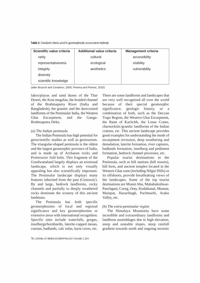
Table 3. Standard criteria used in geomorphosite assessment methods
Scientific value criteria Additional value criteria Management criteria
rarity cultural accessibility
representativeness ecological visibility
integrity aesthetics vulnerability
diversity
scientific knowledge
(after Bruschi and Cendrero, 2005; Pereira and Pereira, 2010)
16 JOURNAL OF INDIAN GEOMORPHOLOGY: VOLUME 3, 2015
movements. These tallest mountains in theworld extend over a length of nearly 2500 kmand consist of several parallel tectonicmountain chains, separated by thrust faults.The mountain building process, which startedabout 55 Myr as a result of the collision of theIndian and Eurasian Plates, has given rise tofour, almost parallel, morpho-tectonic zonesnamely the Siwaliks, the Lesser Himalaya, theGreater Himalaya, and the Tethys Himalaya.Each belt displays a distinct set of landformsand scenery.
The spectacular rugged relief of theHimalayan landscape is the result of ongoingtectonic uplift, rapid valley incision, landslideerosion and glacial erosion (Kale, 2014c).Due to their location in the collisional settingand ongoing tectonic movements, thesemountains are highly deformed and showmultiple evidence of tectonic deformation.Distinctive tectono-genic, fluvial and glaciallandforms include snow-covered jaggedpeaks, alpine mountains, long glaciers,cirques and glacial valleys, moraines, deepgorges across anticlines, intermountain basins(duns), strath and fill terraces, drainagenetwork anomalies, knickpoints, palaeolakes,landslides, etc. All these forms and featuresare significant to geoscience education andresearch.
As a result of the enormousgeomorphodiversity in this mountainousterrain, there are countless geomorphositesthat are capable of providing opportunities forgeotourism and, thus, sustaining local andstate economies. Some of the most captivatinglandscapes in the Himalaya are observed inthe Kashmir Valley, Ladakh, Lahul-SpitiValley, Chamoli, Garhwal and SikkimHimalaya. Some leading popular touristdestinations include Leh, Kullu-Manali,Shimla, Mussoorie, Nainital, Darjeeling,Gangtok, Kalimpong, Tawang, etc.
(c) The Indus-Ganga-Brahmaputra plainsThis vast alluvial landscape created by the
Indus, Ganga and the Brahmaputra (IGB)Rivers and their tributaries lies to the south ofthe Himalaya Mountains and provides classicexamples of alluvial landforms on differentscales. The IGB Plains are primarilycomposed of fan, floodplain, channel anddeltaic deposits (Kale, 2014c).
Noteworthy landforms and features in thislandscape include floodplains, alluvial fans(megafans), meandering and braidedchannels, river terraces, badlands, multiplepalaeochannels, ox-bow lakes, etc. Eventhough some of these geomorphosites may notbe very appealing to the general public andtourists, they undoubtedly have high potentialfor scientific studies as fascinating outdoorlaboratories for fluvial geomorphologistsinterested in alluvial rivers. The mega-fans inparticular have attracted greater attention fromglobal geoscience community. Anothernoteworthy feature in this geomorphicprovince is the Chambal Badlands thatinspires awe amongst visitors.
(d) The Indian coastlineIndia has a coastline of around 7500 km,
with varying rock types, structure, tidal rangeand wave energy. Representative and eye-catching coastal landforms form a significantpart of the Indian geomorphosites andgeomorphoheritage sites. Rocky landforms(sea cliffs and wave-cut platforms),depositional features (beaches, sand dunes,bars, spits, mud flats, and mangrove swamps)and coral landforms (reefs and atolls) are bothaesthetically significant and scientificallyimportant. Famous beaches, such as Mandvi,Diu, Juhu, Diveagar, Ganpatipule, Calangute,Colva, Gokarna, Kollam, Varkala, Marina,Ennore, Rushikonda, Yarada, Konark, Puri,Digha, etc. attract thousands of tourists from
17
India and abroad every year. Other outstanding landforms that are of
interest to tourists and scientists alike includethe large saline marshland of the Rann ofKachchh, cliffs and shore platforms in
miliolite around Diu, chain of brackishlagoons and lakes (kayals) of the MalabarCoast, the coral islands of Lakshadweep, theChilka Lake and the Pulicat Lagoon on theeast coast, the Sundarbans tidal delta of West
Table 4. Geo-coding of the parameters for classification of geomorphosites
18 JOURNAL OF INDIAN GEOMORPHOLOGY: VOLUME 3, 2015
Tabl
e 5. S
ome I
ndian
exa
mple
s of p
oten
tial g
eom
orph
osite
s and
their
10-
digit g
eo-c
ode
and
2-dig
it pos
tcode
(
19
20 JOURNAL OF INDIAN GEOMORPHOLOGY: VOLUME 3, 2015
Tabl
e 5. S
ome I
ndian
exa
mple
s of p
oten
tial g
eom
orph
osite
s and
their
10-
digit g
eo-c
ode
and
2-dig
it pos
tcode
(
Note
:Se
e Tab
le 4
for e
xplan
ation
of g
eo-co
des.
* = a
fter K
ale (2
014b
); +
= af
ter V
aidya
nadh
an a
nd S
ubba
rao
(201
4); #
= a
fter A
nant
hara
mu
et a
l.(20
01);
!=
after
GSI
(201
2)
21
Tabl
e 5. S
ome I
ndian
exa
mple
s of p
oten
tial g
eom
orph
osite
s and
their
10-
digit g
eo-c
ode
and
2-dig
it pos
tcode
(
Bengal, and the Andaman-NicobarArchipelago.
Scientifically and educationally significantgeomorphosites include modern features, suchas estuaries, deltas, mud flats, sand dunes,spits, bars, cliffs, shore platforms, stacks,beaches, beach cusps, etc. and relict featuressuch as beach rocks, aeolianite and dead cliffsas well as raised beaches, wave-cut platforms,oyster beds, coral reefs and tidal deposits. Allthese features are significant from the point ofview of absolute and relative changes in sealevel.
(e) The Thar desert and LadakhThe barren and desolate landscape of the
arid regions generally inspires awe amongsttourists. India has a hot desert (the TharDesert) as well as a cold desert (Ladakh).These two different types of dryland regionshave outstanding geomorphoheritage valuebecause of their aesthetically appealing aswell as scientifically significantcharacteristics. In recent years some places,such as Jaisalmer and Leh, are becoming verypopular tourist destinations.
The Thar Desert displays a landscapedominated by sand dunes of different typesand sizes, as well as erosional features createdby the fluvial and aeolian processes. Parabolicdunes, playas and ephemeral streams are thekey features of the Indian desert.
The cold-desert landscape of Ladakhdisplays features created by cryogenicweathering, rivers, glaciers, and aeolian andmass movement processes. The area alsoprovides number of opportunities to studytectono-genic and structural landforms. Otherdistinctive features include number of fans(alluvial and debris-flow dominated), taluscones, fan belts (bajada), strath and alluvialterraces, moraines, sand dunes and remnantsof palaeolakes.
Gaps in geomorphodiversity informationThe terms “geosite” and “geodiversity” are
being used by geologists andgeomorphologists since 1990s (Sharples,2002; Gray 2004). Inventory covering keygeological and geomorphological sites andlandscapes has been prepared by manycountries (European countries, USA andAustralia, in particular). Althoughconsiderable work has been completed inunderstanding India’s geodiversity in terms ofrocks, minerals and fossils by the GeologicalSurvey of India (GSI) since its inception in1851, there is considerable gap in theknowledge of India’s geomorphodiversity. Inspite of the fact that a few attempts have beenmade to identify key geomorphosites/geomorphoheritage sites in India (Kale,2014a), there are strategic gaps in theinformation on India’s landforms, landscapes,rivers and soils. Till date there is no officialnational inventory of geomorphosites in India.Further, no attempt has been made to evaluatethe quality of geomorphological heritage fromthe point of view of geotourism,geoconservation and management.
Geomorphosite assessment andclassification
The value of geomorphosites can bescientific/educational, intrinsic, cultural,aesthetic, economic and functional (Gray2004) as well as ecological (Reynard, 2005).Several classification and assessment methodshave been suggested and used since the termgeomorphosites was introduced by Panizza(2001). The assessment methods are based onmultiple criteria – three of which are common,namely, scientific value, additional value, andmanagement criteria (Kubalíková, 2013)(Table 3).
Panizza (2001) suggested assessment ofthe geomorphosites on the basis of scientific
22 JOURNAL OF INDIAN GEOMORPHOLOGY: VOLUME 3, 2015
criterion (as a model of geomorphologicalprocess or as an ecological support),pertinence (world-wide to local), the degreeof preservation (well-preserved to poorly-preserved), and the degree of damage (nil todestroyed). Coratza and Giusti (2005)proposed a methodology to assess thescientific quality of a geomorphosite in termsof weighted mean, on the basis of sevencharacteristics – value for the scientificresearch, educational value, areal extent,rareness, integrity, exposure and added value.Reynard et al. (2007) based their assessmenton five criteria – scientific value (integrity,representativeness, paleogeographical value,and rareness), ecological value (ecologicalimpact and protected species), aesthetic value(number of viewpoints, contrasts, verticaldevelopment), cultural value (religious,historical and artistic importance), andeconomic value (economic products).
Pereira and Pereira (2010) suggested anassessment methodology for potentialgeomorphosites based on three principalcriteria – geomorphological intrinsic value(scientific and other geomorphologicalvalues), potential use (accessibility, visibilityand use of other natural or cultural values),and need for protection (deterioration andvulnerability). Bruschi et al. (2011) proposeda parametric method based on three sets ofcriteria: intrinsic quality, potential for use andprotection needs. Hassan et al. (2012) usedthe Analytic Hierarchy Process (AHP) toassess geosites using multiple attributes(climate, topography, geomorphic forms,infrastructure, safety, distance, etc.).
All the above methods, involving multiplecriteria assessment and classification, arebased on ranks, scores or weights assigned bythe researcher or experts. Values (between 0and 1, or from 1 to 5, etc.) are assigned to eachof the criterion and attribute to reflect their
relative importance or status. Finally, the sumof ranks/scores or weights or their mean valueis taken into consideration to determine theoverall importance, potential or value of thesite (or sites) under review.
Ranking and scoring is a simple way tomanage multivariate datasets, especially whenrequisite data are lacking or difficult togenerate. However, the classification andassessment, based on scoring/ranking, involvevarying degree of subjectivity (Bruschi et al.2011). More often than not the results cannotbe replicated. Further, the sum or mean valueof the scores, ranks or weights of multiple setsof criteria for a geomorphosite do not provideany idea about the type of landform/landscape, the associated geomorphic process(or processes), tentative location, scientificimportance, additional value, integrity,accessibility, etc. This is the severe limitationof all the methods of geomorphositeassessment and classification proposed so far.
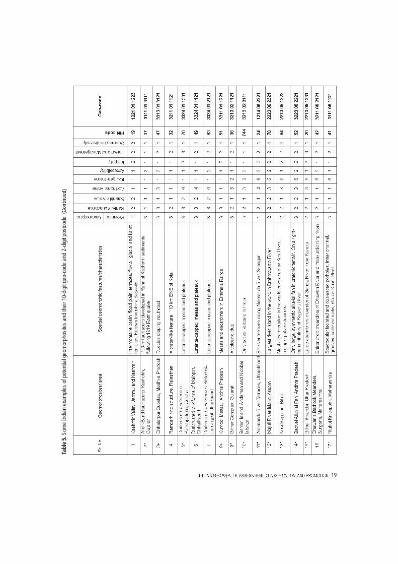
Therefore, a simple, 10-digit geo-codingsystem for the geomorphosites of India isproposed here (Table 4). This coding is usedto establish a classification and priority ofgeomorphosites, both in terms of geotourismpromotion and management. The first digit (1to 3) represents the major geomorphicprovince of India. The second digit (1 to 3)stands for the rarity/abundance of the site. Thethird digit (1 to 3) represents the scientific orintrinsic value of the geomorphosite. Theadditional value (touristic, cultural, ecologicalor economic) is denoted by the fourth digit (1to 4). The fifth and sixth digits (01 to 15)denote the geotheme number adopted by theInternational Union for Conservation ofNature (IUCN). The seventh digit (1 to 3)indicates the accessibility. The integrity or thestate of preservation of the geomorphosite isrepresented by the eighth digit (1 to 3), andthe potential threat and management is
23
denoted by the ninth digit (1 to 3). The tenthdigit (1 to 3) represents the degree ofgeomorphodiversity (geomorphospot,geomorpholocality, and geomorphopark,respectively). Following the definition of‘geoparks’ by Global Network of NationalGeoparks (GGN) (UNESCO, 2006), ageomorphopark has been defined here as “asufficiently large area comprising of a numberof geomorphological features of specialscientific importance, rarity or beauty”. Table5 gives examples of four dozen potentialgeomorphosites in India and their 10-digitgeo-codes. Their approximate location of thesite/area is indicated by the 2-digit postcode.
(geomorphosites) are considered equivalent tofamous historical monuments (Taj Mahal,Konark Sun Temple, Khajuraho Temples,Mahabalipuram Monuments, HampiMonuments, etc.) and archaeological sites(Kalibangan, Lothal and Dholavira Harappansites; Bhimbetka rock shelters; Ajanta, Elloraand Elephanta caves, etc.). Therefore,geotourism also places considerable emphasison providing comprehensive information tothe visitors, sightseers and local communitiesabout the scientific aspects of a specificlandform (its special characteristics,significance, age and genesis). Severalapproaches have been adopted to promotegeotourism (Dowling, 2011). Scientificinformation about the landform/feature isshared with the tourists through colourfulpamphlets, infographic brochures/posters andeducational handbooks, or by erectinginformative panels at the geomorphosites/geomorphoheritage sites or through museumsand thematic guided tours. The promotionalmaterial includes simple maps, colourphotographs, sketches and diagrams, and
explanation that are understood by the generalpublic. These traditional methods, however,have certain limitations. The informationregarding geomorphosites cannot be accessedin real time. Therefore, geotourism will bebest promoted by using web-based GoogleMaps. Comprehensive information about thegeomorphological wonders should be madeavailable to the tourists by way of websitesbefore their visit. Now-a-days tourisminfographics are being used to promotetourism.
However, to promote geotourism in ourcountry first a national inventory ofgeomorphosites / geomorphoheritage sites isrequired. It is obvious that in the developmentof a peer-reviewed national inventory,different academic and professionalorganizations, research institutions anduniversity departments should be involved.There is also a need for a body to setup,maintain and regularly update the database.There is also a need to have simple andinformative geomorphodiversity maps fordifferent regions (national, state, site-specific). Systematic mapping of landforms isrequired to achieve a national assessment ofIndia’s landforms. Such maps will facilitate indetermining the outstanding geoheritagesites/areas in India.
Concluding remarksThe Indian region is endowed with
extraordinary and rich geo-wealth. There arecountless fascinating and exquisite features,landforms and landscapes in the sub-continentthat have immense scientific, cultural, andsocio-economic value. However, geologicaland geomorphological heritage is notsufficiently recognised in India. This isevident from the fact that the GSI declared thelist of National Geological Monuments onlyin 2001 (that is, 150 years after its inception)
24 JOURNAL OF INDIAN GEOMORPHOLOGY: VOLUME 3, 2015
and only seven natural properties from Indiaare included in the list of World Heritage Sitesin the last three decades (since 1983). Further,not a single geopark from India appears in thelist of Global Geoparks Network (GGN),supported by UNESCO. Furthermore, till datethere is no official national inventory ofgeomorphosites. It is obvious that not onlygeotourism has to be promoted in India butalso that the geo-wealth and geodiversity ofour country has to be conserved and preservedfor posterity. Several institutions/organisations such as the Geological Surveyof India (GSI), the Geological Society ofIndia, the Indian Institute ofGeomorphologists (IGI), etc. and the Ministryof Earth Sciences (MoES) as well as theuniversity earth science departments have akey role to play in this overdue activity. Anational geomorphosites inventory and a fullunderstanding of the scientific, cultural,aesthetic, economic, and ecological value ofthe geomorphological wonders are vital fromthe standpoint of geotourism promotion andconservation of India’s rich geoheritage.
AcknowledgmentThe author acknowledges the support provided
for this work by the S.P. Pune University under theDepartmental Research and Development Program(DRDP).
ReferencesAnantharamu, T.R., Bellur, D. and Bhasker, A. A.
(2001) National Geological Monuments.Geological Survey of India, SpecialPublication, 61(6): 98p.
Brocx, M. and Semeniuk, V. (2007) Geoheritageand geoconservation – history, definition, scopeand scale. Journal of the Royal Society ofWestern Australia, 90: 53–87.
Bruschi, V. M. and Cendrero, A. (2005). GeositeEvaluation; Can we measure intangible values?Il Quaternario, 18(1): 293–306.
Bruschi, V. M., Cendrero, A., and Albertos, J. A. C.(2011) A statistical approach to the validationand optimization of geoheritage assessmentprocedures. Geoheritage, 3: 131–149.
Coratza, P. and Giusti, C. (2005) Methodologicalproposal for the assessment of the scientificquality of geomorphosites. Il Quaternario,18(1): 305–313.
Dowling, R. K. (2011) Geotourism’s GlobalGrowth. Geoheritage, 3(1): 1–13.
Gray, M. (2004) Geodiversity: Valuing and ConservingAbiotic Nature. Wiley, Chichester, 434p.
GSI (2012) Travel brochure on NationalGeological Monuments of India: Region South.Geological Survey of India, Hyderabad, 12p.
Hassan, S. S. Andrzej, K, and Einafshar, A (2012)A tourism demand based method of geositesassessment on geotourism prioritizationmodeling: The case of Razavi KhorasanProvince. Journal of Hospitality Managementand Tourism, 3(5): 82–94.
Kale, V. S. (2009) DEM–based studies of someoutstanding fluvial landforms in India. In:Sharma H.S. and Kale, V.S. (eds.)Geomorphology of India. Prayag PustakBhavan, Allahabad: 59–68.
Kale, V. S. (ed)(2014a) Landscapes andLandforms of India, Springer, Dordrecht, 271p.
Kale, V. S. (2014b) Geomorphosites andGeoheritage Sites in India. In: Kale, V. S (ed).Landscapes and Landforms of India, Springer,Dordrecht: 247–267.
Kale, V. S. (2014c) Geomorphic History andLandscapes of India. In: Kale, V. S (ed).Landscapes and Landforms of India, Springer,Dordrecht: 25–37.
Panizza, M. (2001) Geomorphosites: concepts,methods and examples of geomorphologicalsurvey. Chinese Science Bulletin (Suppl.), 46:4–6.
Panizza, M. (2009) The Geomorphodiversity ofthe Dolomites (Italy): A key of GeoheritageAssessment. Geoheritage, 1(1): 33–42.
25
Pellitero, R, Ruiz–Flaño, P., Serrano, E. andGonzález–Amuchastegui M. J. (2011)Geodiversity and geomorphosite assessmentapplied to a natural protected area: the Ebro andRudron Gorges Natural Park (Spain).Geoheritage, 3:163–174.
Pereira, P. and Pereira, D. (2010) Methodologicalguidelines for geomorphosite assessment.Géomorphologie: Relief, Processus,Environnement, 1(3): 215–222
Raina, V. K and Srivastava, D. (2008) GlacierAtlas of India. Geological Society of India,Bangalore, 315p.
Ranganathan, N. and Jayaram, S. (2006)Geomorphology of Karnataka. KarnatakaGeologists Association, Department of Minesand Geology, Bangalore. 350p.
Reddy, D. R. (ed)(2013) Proceedings of NationalWorkshop and Brainstorming Session onGeoheritage: Need for an Indian Activism.Department of Geology, Andhra University,
Visakhapatnam. May 30–31, 2013, 94p.Reynard, E. (2005) Géomorphosites et paysages.
Reynard, E., Fontana, G., Kozlik, L., Capozza, C.,Lausanne (2007) A method for assessingscientific and additional values ofgeomorphosites. Geographica Helvetica,62(3):148–158.
Sharples, C. (2002) Concepts and Principles ofGeoconservation. Tasmanian Parks andWildlife Service.http://dpipwe.tas.gov.au/Documents/geoconservation.pdf (retrieved on 2013-11-01).
UNESCO (2006) Global Geoparks Network.Geoparks Secretariat, Global EarthObservations Section, Division of Ecologicaland Earth Sciences, UNESCO, Paris
Vaidyanadhan, R. and Subbarao, K. V. (2014).Landforms of India from topomaps and images.Geological Society of India, Bangalore: 135p.
26 JOURNAL OF INDIAN GEOMORPHOLOGY: VOLUME 3, 2015


![SABKA VISHWAS (LEGACY DISPUTE RESOLUTION) SCHEME, 2019 · the Sabka Vishwas (Legacy Dispute Resolution) Scheme Rules, 2019] SABKA VISHWAS (LEGACY DISPUTE RESOLUTION) SCHEME, 2019](https://static.documents.pub/doc/80x56/603ce30e0114d839933ee19e/sabka-vishwas-legacy-dispute-resolution-scheme-2019-the-sabka-vishwas-legacy.jpg)


