16
September 2020 Volume 52, Number 3 U T A H G E O L O G I C A L S U R V E Y The UGS Response to the March 18, 2020, Magnitude 5.7 Magna, Utah, Earthquake and Aftershock Sequence SURVEY NOTES
September 2020Volume 52, Number 3
U T A H G E O L O G I C A L S U R V E Y
The UGS Response to the March 18, 2020, Magnitude 5.7 Magna, Utah, Earthquake and Aftershock Sequence
SURVEY NOTES

DIRECTOR'S PERSPECTIVEContentsThe UGS Response to the March18,
2020, Magnitude 5.7 Magna, Utah, Earthquake and Aftershock Sequence ........................................... 1
Energy News ........................................... 5
Glad You Asked ...................................... 8
GeoSights ............................................. 10
Survey News ......................................... 12
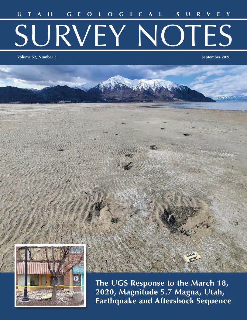
Design • John GoodCover • Subsidence features on the mud flats behind the Saltair building likely caused by liquefaction from the 2020 M 5.7 Magna, Utah, earthquake. Photo by Adam Hiscock. Inset: Damage to commercial buildings in Magna from the 2020 M 5.7 Magna, Utah, earthquake. Photo by Emily Kleber and Jessica Castleton.
State of Utah Gary R. Herbert, Governor
Department of Natural Resources Brian Steed, Executive Director
UGS Board Elissa Richards, Chair
Ken Fleck, Vice Chair Pete Kilbourne, Dave Garbrecht, Sam Quigley, Marc Eckels, Rick Chesnut, David Ure (Trust Lands Administration-ex officio)
UGS STAFFAdministration Bill Keach, Director Michael Hylland, Deputy Director Starr Soliz, Secretary/Receptionist
Cheryl Gustin, Secretary/Receptionist Jodi Patterson, Financial Manager Linda Bennett, Accounting Technician Editorial Staff • Jennifer Miller Lori Steadman, John Good, Jackie Dewolfe
Geologic Hazards • Steve Bowman Richard Giraud, Jessica Castleton, Tyler Knudsen,
Greg McDonald, Adam McKean, Ben Erickson, Adam Hiscock, Gordon Douglass, Emily Kleber
Geologic Information & Outreach • Michael Hylland
Mark Milligan, Lance Weaver, Gentry Hammerschmid, Stephanie Carney, Kimm Harty, Jim Davis, Marshall Robinson, Jay Hill, Brian Butler, Suzanne Sawyer, Mackenzie Cope, Martha Jensen
Geologic Mapping & Paleontology • Grant Willis Jon King, Kent Brown, Basia Matyjasik, Donald Clark,
Bob Biek, Zach Anderson, James Kirkland, Martha Hayden, Don DeBlieux, Rosemary Fasselin
Energy & Minerals • Michael Vanden Berg Jeff Quick, Taylor Boden, Thomas Chidsey, Tom
Dempster, Andrew Rupke, Christian Hardwick, Peter Nielsen, Elliot Jagniecki, Ryan Gall, Stephanie Mills
Groundwater & Wetlands • Hugh Hurlow Janae Wallace, Paul Inkenbrandt, Lucy Jordan,
Stefan Kirby, Diane Menuz, Nathan Payne, Emily McDermott, Miles McCoy-Sulentic, Trevor Schlossnagle, Pete Goodwin
Survey Notes is published three times yearly by the Utah Geological Survey, 1594 W. North Temple, Suite 3110, Salt Lake City, Utah 84116; (801) 537-3300. The UGS provides timely scientific information about Utah’s geologic environment, resources, and hazards. The UGS is a division of the Department of Natural Resources. Single copies of Survey Notes are distributed free of charge within the United States and reproduction is encouraged with recognition of source. Copies are available at https://geology.utah.gov/map-pub/survey-notes/. ISSN 1061-7930
ards Portal was released in May of this year (www.geology.utah.gov/apps/hazards). Here, one can access available hazard data for any location in the state. Information on faults, landslides, problem soils, flooding, etc., can be researched, and a report can be generated for the
location. We continue to work on new web applications to increase ac-cessibility to UGS data.
Each year the UGS Board selects the winner(s) of the Arthur L. Crawford Award, which “recognizes outstand-ing achievement, accomplishments, or contributions by a current UGS scientist(s) to the understanding of some aspect of Utah geology or earth science.” The winning nomi-nation is highlighted in this issue’s “Survey News” column and below are comments from the Board on all three of this year’s nominees. From the Board Chair, Elissa Richards, “… this was a difficult task because all three nominations were excellent, and the finalists’ achievements and contributions are impressive.”
“The Wasatch Fault Zone research [by Greg McDonald and co-authors] lays the geologic foundation needed for further study and reduction of risks as development increases along the Wasatch Front. It could literally be a life saver and the methodology sets a standard.”
“The Roosevelt Geothermal compila-tion of papers [by Rick Allis and Jo-seph Moore, editors, with multiple co-authors] both clearly and completely describes the geothermal resource and provides a better understanding of the geology of this part of Utah.”
“The Ogden Valley Groundwater pa-per [by Lucy Jordan and co-authors] provides a complete and clear geo-logic context, provides critical in-formation about current and future groundwater use, and sets a stan-dard and methodology that could be applied to Utah’s developing back valleys and other areas.”
Such an interesting time to live and work. A pandem-ic has been with us since March. Local, state, and national economies have been severely impacted. Social issues have stirred many emotions in many people. Through it all the UGS continues to exemplify compassion and profes-sionalism. Lives are being lived and work is being done. For the past four plus months the majority of UGS staff have been working from home and in the field. Work continues to progress, and we continue to look for ways to increase productivity AND maintain a sense of community.
For the Utah Geological Association’s July meeting, I spoke about curiosity, patterns, and discovery. Many great discoveries come from being curious first, and then recognizing patterns in the data. A favorite line of mine, by Mark Twain, is as true today as it was when written in 1889: “You cannot depend on your eyes when your imagination is out of focus1.” For me, our science is about focusing our imagination to make more sense of the world around us. Technology plays a role in focusing our eyes and mind on what can be newly seen. One of the questions posed after the talk asked, “What do you see in the future for the UGS and technology?” One as-pect is finding new ways to derive new insights from our historical archives. Nearly every report, research paper, and map are now digitally archived. Digitally available data can provide the basis for new avenues of research. The imagination can be turned loose on “What if?” and “How?” questions. Which in turn lead to better insights on public needs such as understand-ing groundwater supplies, building safety, natural hazards, critical miner-als, etc.
Over the past few years, the UGS Web Services team, working closely with the various programs, has been busy developing new online applica-tions which improve access to UGS digital data. The Utah Geologic Haz-
by Bill Keach
1A Connecticut Yankee in King Arthur’s Court, Mark Twain, 1889

by the UGS Geologic Hazards Program
The UGS Response to the March 18, 2020, Magnitude 5.7 Magna, Utah, Earthquake and Aftershock Sequence
Early on the morning of March 18, 2020, a magnitude (M) 5.7 earthquake shook the Wasatch Front. The earthquake was centered about 8 miles below Magna, Utah, and about 10 miles west of downtown Salt Lake City. The earthquake was widely felt along the
Wasatch Front and into Idaho, Wyoming, and Colorado as shown by the Did You Feel It reports to the U.S. Geological Survey (USGS). For-tunately, there were no deaths from the earthquake; however, multiple injuries were reported as well as damage to buildings and homes.
The Magna earthquake was the largest along the Wasatch Front since pioneer settlement in 1847 and serves as a reminder that Utah is seismically active and that damaging earthquakes do occur. In fact, the epicenter of the 2020 Magna earthquake is very near the epicenter of the 1962 M 5.2 Magna earthquake, which caused structural damage to buildings in the area. The Wasatch fault zone
is expected to produce an earthquake around M 7.0 in the future and has the potential to produce a M 7.6 based on knowledge of past, prehistoric earthquakes and specific fault lengths. In terms of energy, a M 7.0 earthquake would release 90 times more energy than the M 5.7 Magna earthquake and would be much more damaging.
To assist emergency managers and first respond-ers to the earthquake, the Utah Geological Survey (UGS) immediately activated its Emergency Oper-ations Center (EOC), where scientific information collected on the earthquake could be coordinated and managed. Initial response included deploy-ment of two field-reconnaissance teams to inves-tigate geologic effects from the earthquake and to provide scientific assistance to first responders as needed. The scientific information we collected was shared with the Utah Division of Emergency Management’s (UDEM) State EOC and the Univer-sity of Utah Seismograph Stations (UUSS). In addi-tion, the UGS worked extensively with the UUSS to determine which fault(s) were involved with the earthquake and subsequent aftershocks.
Digital Clearinghouse
Within two hours of the earthquake, the UGS es-tablished a digital web-based clearinghouse (https://geodata.geology.utah.gov/pages/search.php?search=!collection609) to collect, distribute, and archive important data and other information on the earthquake. The clearinghouse provides timely information to the public and media and pro-vides future researchers with the necessary data to investigate earthquake effects. Clearinghouse data are also critical to the performance evaluation of infrastructure during earthquakes, including the ef-fectiveness of building codes, material types, and construction methods. These evaluations can reduce the impact and effects from future earthquakes.
116˚W 114˚W 112˚W 110˚W
38˚N 38˚N
40˚N 40˚N
42˚N 42˚N
WASATCH FRONT URBAN CORRIDOR, UTAHUSGS Community Internet Intensity Map
2020-03-18 13:09:31 UTC 40.751N 112.0783W M5.7 Depth: 11 km ID:uu60363602
Processed: Mon Jul 20 01:28:17 2020 vmdyfi1
Salt Lake City
Provo
Sandy
OgdenLayton
Idaho Falls
Pocatello
Grand Junction
Logan
Twin Falls
Rock Springs
Payson
Elko
Mountain Home BlackfootRiverton
38661 responses, 36312 plotted in 332 ZIP codes and 2 cities (Max CDI = VI)
CITY SIZE
2M+
100,000+10,000+<10,000
116˚W 114˚W 112˚W 110˚W
38˚N 38˚N
40˚N 40˚N
42˚N 42˚N
100 miles
INTENSITY
DAMAGE
SHAKING
I II-III IV V VI VII VIII IX X+none none none Very light Light Moderate Moderate/Heavy Heavy Very Heavy
Not felt Weak Light Moderate Strong Very strong Severe Violent Extreme
USGS Did You Feel It public responses to the Magna earthquake (shown as a star on the map). Colored county footprints represent the intensity of earth-quake ground shaking reported by the public. Warmer colors represent more extreme shaking and cooler colors represent less intense shaking. https://earthquake.usgs.gov/archive/product/dyfi/uu60363602/us/1595208519431/uu60363602_ciim.jpg
1A Connecticut Yankee in King Arthur’s Court, Mark Twain, 1889
September 2020 1

Various organizations contributed to the Magna earthquake clearinghouse, including the UGS, Salt Lake County, the UUSS, the USGS, the Utah Department of Transportation (UDOT), the Earthquake Engineering Research Institute (EERI), UNAVCO, the Utah State Historic Preservation Office, UDEM, Utah State University, Utah Valley University, the Natural History Museum of Utah, Stan-ford Research Computing Center, the Utah Geological Association, Granite School District, StrongMotions Inc., Geohazards TEP, Poll Sound, and Salt Lake City. Additionally, we began a public outreach campaign through social media to encourage impacted citizens to share their photographs and videos. Seventeen people responded and contributed 50 photographs and 15 videos.
The majority of submitted items were photographs documenting damage to structures and ground deformation caused by earthquake shaking. Numerous maps and diagrams from scientists were submitted to contextualize the main shock and sub-sequent aftershocks. Submitted videos documented the varied intensity of shaking experienced in Salt Lake Valley. The contri-butions, nearly 800 submissions, to the clearinghouse have provided great insight to the impacts of the M 5.7 Magna, Utah, earthquake and will be a valuable resource for future researchers.
Field Reconnaissance
In the hours following the earthquake, the UGS deployed field teams to document geologic effects in areas determined to be susceptible. A M 5.7 earthquake is too small for fault movement to rupture the ground and offset the ground surface in the Intermountain West. However, the field teams observed surface cracking, liquefaction, and lateral spread features which were mostly a result of ground shaking.
Liquefaction was the most widely observed geologic effect due to ground shaking from the earthquake. Liquefaction is a phenom-enon where sandy, water-saturated soil temporarily loses strength due to strong ground shaking from an earthquake. The ground may behave like a fluid, causing damage to infrastructure like buildings, roads, and pipelines. Liquefaction from the Magna earth-quake was observed along the Jordan River and near Great Salt Lake, where groundwater levels are high. The UGS field reconnais-sance teams observed several types of liquefaction, including sand boils, ground cracking, and lateral spreading.
The day after the main shock, UGS field teams were notified by UDOT of possible liquefaction features near the Interstate 80/State Route 202 interchange near Saltair. Upon investigation, our field teams observed sand boils on land and below water, as well as ground cracking within the engineered fill at the interchange. Using a UGS small unmanned aircraft system (sUAS), field teams were able to observe the extent of underwater sand boils, which were much more numerous than those on land. Underwater sand boils were observed in other ponds at the interchange, as well as along the access road to the nearby Great Salt Lake Marina State Park.
Beyond the deformation observed near Saltair, UGS geologists looked for ground shaking-related damage within a several mile radius from the epicenter, including sites along the Jordan River, marshy ar-eas, and the foothills and canyons of the Wasatch Range where rockfall-prone out-crops are known. Two places along the Jordan River had minor lateral spreading that consisted of several-foot-long zones of fresh, transverse cracking of riverbank deposits, and we discovered a relatively recent rockfall at the mouth of Parleys Canyon that upon further inspection likely predates the earthquake. We also docu-mented two rockfalls sourced from a Ter-tiary-age conglomerate: one just west of Ensign Peak and the other several miles up City Creek Canyon. Both rockfalls had fresh exposures on the source outcrops, impact craters, furrows, and downed and broken scrub oak through the runout zones and rock debris and boulders from the detached blocks as they broke apart while traveling downslope. Overall, how-ever, we observed no major or widespread ground shaking-related features that could be directly attributed to the earthquake.
The area around The Great Saltair concert venue had numerous liquefaction features within fills associated with the Interstate 80/State Route 202 interchange and The Great Saltair parking area. Aerial reconnaissance via sUAS showed liquefaction features including numerous underwater sand boils.
2 SURVEY NOTES

Location of ground shaking-related damage documented by field reconnaissance teams.
Which Fault Caused the Main Earthquake?
Immediately following the Magna earthquake, the UGS and the UUSS began working to identify and understand the fault or faults that moved and caused the earth-quake and subsequent aftershocks. Since the earth-quake-producing fault(s) did not rupture the ground surface, the UGS analyzed available geologic mapping and gravity data, comparing it with available seismicity data from the UUSS, to identify suspected faults.
Based on preliminary data available for the Magna main shock and larger aftershocks, the UGS identified several possible source faults. One area of interest is called the Saltair graben—an inferred basin fault struc-ture—which may be influencing some of the Magna aftershock locations. However, this area was probably not responsible for the main shock. After receiving and analyzing more data, it seems likely that the main shock resulted from movement of a previously unidentified fault potentially related to the Wasatch fault zone deep in the subsurface.
Aftershocks
Thousands of aftershocks followed the main earthquake. As of July 9, 2020, the UUSS had recorded 2,343 aftershocks. Most of the aftershocks occurred in two main areas: (1) a western grouping near the mainshock location and (2) an eastern group-ing near the West Valley fault zone. Many of the western grouping of aftershocks occurred along a west-dipping trend that highlights a hypothetical west-dipping fault. Both areas of aftershocks have geologists and seismologists asking many questions about what the structure of the Salt Lake Valley subsurface geology looks like and how the faults connect miles down below the surface. These and many other questions will be studied by geologists and seismologists for some time.
80
15
GSLMarina
Saltair
Jordan River
0 1 2 MilesN
Salt LakeCity
Lateral spread cracks
Sand boils
Liquefaction
RockfallRockfall
Ensign Peak
RockfallParleys
Canyon
City Creek Canyon
Magna earthquake
epicenter
Great
Salt
Lake
Minor ground shaking-related lateral spreading observed along the Jordan River.
September 2020 3

0–2.02.0–3.03.0–4.04.0–5.0
5.0–6.09/5/1962 MagnaEarthquake (M 5.2)
Earthquake magnitudeFault trace
Salt Lake City
Great Salt Lake
Wasatch Range
Explanation14 km
10 km
N
Image from three-dimensional web scene showing the location of the Magna earthquake and aftershocks below the Salt Lake Valley floor.
Map showing Magna earthquakes and aftershocks with mapped Quaternary (<2.6 million years) faults and the Saltair graben, a potentially related inferred basin fault structure. Current research suggests that the main shock re-sulted from movement of a fault potentially related to the Wasatch fault zone at depth. Numerous af-tershocks appear to be related to the West Valley fault zone as well.
Earthquake 3D Visualization
On the day of the earthquake, the UGS created an interactive three-dimensional (3D) web scene using a geographic informa-tion system (GIS) data set that represented the main shock and subsequent aftershocks. The web scene models the earthquake locations in three-dimensional space using ArcScene GIS software with data provided by the UUSS. The initial scene was cre-ated using the GIS earthquake locations, imagery, hazardous (Quaternary) fault lines, and a digital elevation model. It was then converted into a web scene and used to create an interactive ArcGIS Online web application (https://utahdnr.maps.arcgis.com/apps/CEWebViewer/viewer.html?3dWebScene=8df0f2ead6e74ab1969f7f49686f8875). The last update was on July 9, 2020, that displayed over 2,300 locations. As additional aftershocks are detected, the 3D web scene will be periodically updated.
E
!!
!!
!!
!!
!!
!!
!!
!!
!!
!!
!!
!
E
!!
!!
!!
!!
!!
!!
!!
!!
!!
!!
!!
!!
!!
!!
!!
!!
!!
!!
!!
!!
!!
!!
!!
!!
!!
!!
!!
!!
!!
!!
!!
!!
!!
!!
!
E
E
!!
!!
!!
!!
!!
!!
E?
!!
!!
!!
!!
!!
!!
!!
!!
!!!
!!
!!
!!
!!
!!
!!
!!
!!
!!
E
E
?
?
!!!!
!!!!!
!!
!!
!!
!!
!!
!!
!!
!!
!!
E
?
?
!!
!!
!!
!!
!!
!!
!!
!
!!
!!
!!
!!
E?
!
E
E
!
!
!
!!
!!
!
!
E!!
!!!!!!!
E !!
!!
!!
E
E
E
!!
E EE
E
!
E
EE
!
!!!
!!
!!
!!
!
EE E
E!!E
!
E!
!
EE
!!
!
!!
!!
!!
!
!!
!!
!!
!!
! ! ! ! !
!!
!!
!!
! ! !
! ! ! !
! !
!!
!!
!!
!!
!!
!!
!!
!
!!
!!
!!
!!
!!
!!
!
E
!!
!!
!!
!
!
!!!
!!
!!
!
!!!
!!
!!
!E
!!
!
!
!
!
!!!!!
!!!!
!!!!!
E
!!
!!
!!
!!
!
!!
!!
!
!!
!!
!
!!
!!
!!!
!!
!!
!!
!!!
!!
!!
!!
!
!
!!
!
E
!
!
!
!!
!!
!!
!!
!!
E
!
Saltair Graben
West Valley Fault Zone
Great SaltLake Fault
Zone
E
0 21 Miles
0 21 KilometersÜ HarkersFault
Faults Inferred from Drill Hole, Gravity, and/or Seismic Data! ! ! ! ! !E?
Magnitude! ! ! ! ! ! ! ! ! ! ! ! !E
E
112°7'30"W
112°7'30"W
112°0'0"W
112°0'0"W
111°52'30"W
111°52'30"W
40°45'0"N40°45'0"N
(bar and ball on downthrown side of fault)
Inferred
Inferred (New)
Moderately ConstrainedWell Constrained
0–1.01.0–2.02.0–3.03.0–4.0
4.0–5.0
5.0–6.0
9/5/1962 MagnaEarthquake (M 5.2)
Quaternary (<2.6 million years)Active Faults
USGS/UUSS 2020 Magna EarthquakeRecord (as of 5/8/2020)
Magna
DowntownSalt Lake
City
GreatSaltLake
!
!!
!!
!
80
15
Wasatch Fault Zone
Generalized Map of Northern Salt Lake Valley Showing Normal Faultsand Their Relation to the Magna M 5.7 Earthquake
and Aftershocks of March 18–May 8, 2020
4 SURVEY NOTES
-$50 per barrel. Prices rebounded in late April and early May as Russia, Saudi Arabia, and other OPEC+ countries agreed to massive oil production cuts, combined with a more economically driven production decline in the United States due to reduced drilling activity.
The graph on page 6 displays monthly aver-age oil prices for WTI and UB wax, coupled with monthly Utah oil production in thou-sand barrels per day (bbl/day) over the past six years. UB wax sells at a discount due to the limited Salt Lake City refinery market and the challenges of handling the waxy crude. The price crash experienced in late 2014 can help inform how the current price crash will impact oil production over the next several months. Average monthly oil prices bot-tomed out in April 2020 before rebounding in May, June, and July. Unfortunately, despite this price rebound, Utah’s drill rig count fell from eight rigs in early April to zero rigs in early May. Recent drilling mostly focused on horizontal wells in the unconventional Green River/Wasatch play in the Uinta Basin, Utah’s major oil producing area. These unconven-tional wells experience steep production de-clines in the first several months and without constant new drilling, overall production de-clines will be significant.
The COVID-19 pandemic has significantly changed everyday life around the world and in Utah. Starting in mid-March 2020, state leaders issued stay-at-home directives to
try and limit the spread of the coronavirus. This lockdown had major consequences on all aspects of life, including the energy economy in Utah. At the time of this writing (late July), the economy has started to reopen, but new COVID-19 cases continue to surge, leaving doubts about the immediate and long-term economic impact of this pandemic. This article highlights some of the more important and interesting energy metrics from spring 2020 that showed dramatic changes due to COVID-19 responses.
The most significant impact on the energy economy of the COVID-19-related shutdown was the massive drop in oil prices. Two events occurred in March 2020 that dramatically changed oil prices worldwide—Russia and Saudi Arabia entered into an oil price war, flooding the market with new supply, and at the same time the world experienced a massive drop in petroleum product demand linked to COVID-19-related travel restrictions. These two events culminated on April 20, when May futures prices for West Texas Intermediate (WTI—U.S. oil price benchmark) went negative (-$37 per barrel) for the first time in history. Similarly, the price for Uinta Basin wax (UB wax) dropped to an unprecedented
by Michael D. Vanden Berg
Impacts of the COVID-19 Pandemic on Utah’s Energy Industry
Although no deaths occurred and damage was moderate, the recent Magna earthquake is a reminder that Utah is seismically active and that damaging earthquakes do occur. Even with the recent stress relief of the Magna earthquake, enough seismic energy has built up along the Wasatch fault zone that an earth-quake up to about M 7.6 could occur at any time, most likely in the Salt Lake Valley or Brigham City areas. You can prepare for future earthquakes by following the recommendations of the UGS and the Utah Seismic Safety Commission that are outlined in the Putting Down Roots in Earthquake Country Handbook available online at https://ussc.utah.gov/pages/view.php?ref=1 or a printed copy may be obtained from the Natural Resources Map & Bookstore (https://www.utahmapstore.com/).
Additional Information
Utah Earthquakes (1850 to 2018) and Quaternary Faults Map [https://doi.org/10.34191/M-277]
Utah Quaternary Fault and Fold Database online map [https://geology.utah.gov/apps/qfaults/]
UGS Earthquake Hazards web page [https://geology.utah.gov/hazards/earthquakes/]
Utah Geologic Hazards Portal [https://geology.utah.gov/apps/hazards/]
State of Utah Earthquakes website [https://earthquakes.utah.gov/]
Utah Seismic Safety Commission [https://ussc.utah.gov/]
UGS Earthquake Probabilities for the Wasatch Front Region in Utah, Idaho, and Wyoming publication [https://doi.org/10.34191/MP-16-3] and fact sheet [https://pubs.usgs.gov/fs/2016/3019/fs20163019.pdf]
ABOUT THE AUTHORSThe mission of the Geologic Hazards Program is to: 1) respond to geologic hazard emergencies and provide unbiased, scientific advice to local governments and in-cident commanders, 2) investigate and map geologic hazards in urban and other areas (to publish and distrib-ute maps and GIS spatial data), and 3) provide geologic hazard-related technical and educational outreach and information to inform Utahns about hazards. The focus of the Program is to reduce Utah’s life-safety, property, and economic risk from geologic hazards. https://geol-ogy.utah.gov/about-us/geologic-hazards-program/
September 2020 5

After a sustained decrease in oil production over the past 12 months, mostly related to stagnating prices and operator turnover in the Uinta Basin, production plummeted by 27 percent from 93,000 bbls/day in March 2020 to 67,500 bbls/day in May, due to COVID-19-related price reductions—by far the largest two-month decrease in decades. Unfortunately, production will continue to drop, albeit at a lower rate, well into the fall. Early projections indicate that production could drop to about 55,000 bbls/day by fall 2020, the lowest rate in over ten years. These projections would translate to a total 2020 Utah production of about 25 million barrels, down 32 percent from the 2019 total of 37 million barrels.
As previously mentioned, the COVID-19-related travel restrictions and stay-at-home orders created an unprecedented drop in petro-leum production demand. This dramatic decrease can be evalu-ated by looking at the drop in PADD 4 (Petroleum Administration for Defense Districts; PADD 4 includes Utah, Colorado, Wyoming, Idaho, and Montana) refinery utilization rates and refinery produc-tion of motor gasoline, diesel, and jet fuel. Refinery utilization rate refers to the proportion of time a refinery operates in relation to its full capacity. Typically, refineries operate at about 90 percent of their full capacity; however, this rate dropped to 63 percent in April 2020 due to reductions in demand. As states reopened their economies in May and June, demand for products returned and rates bounced back to nearly 90 percent. Motor gasoline produced at PADD 4 refineries displays a similar trend. A massive 43 percent decrease occurred in early April, followed by a sharp rebound as production returned to normal by the end of July. Diesel fuel de-mand only dropped 16 percent in late March and quickly rebound-ed to pre-COVID-19 averages, since commercial trucking never re-ally stopped during the shutdown. Jet fuel demand dropped the
most (84 percent) and has yet to fully recover as commercial air travel continues to suffer from mandated travel restrictions.
The petroleum industry was not the only energy sector affected by the COVID-19 stay-at-home guidelines; electricity demand in Utah was also impacted. Residential electricity usage increased by 9 percent in April 2020 and 21 percent in May, compared with the average of the past five years. This increase was expected as many Utahns transitioned to working from home and schools shut down. In contrast, commercial electricity usage dropped 13 percent in April and 11 percent in May as most businesses had to shut down, at least temporarily. Industrial electricity demand re-mained steady as factories and other industrial complexes mostly continued to operate. Electricity demand should generally return to normal in summer 2020 (data only currently available through May) as the economy begins to reopen, but a resurgence in CO-VID-19 infections could change this scenario.
The COVID-19 pandemic has dramatically impacted all aspects of life in Utah and beyond. These impacts have rippled through our economy, affecting some industries more than others. Utah’s up-stream petroleum industry was severely impacted, and the effects of reductions in price, production, and related jobs to Utah’s rural economy will be difficult to manage for many months, if not years. In contrast, demand for petroleum products in Utah has already mostly rebounded and impacts to electricity demand have been minimal and short lived. As new virus infections continue to surge in July, impacts and restrictions might endure well into the fall, further impacting Utah’s energy economy. The Utah Geological Survey will continue to monitor the effects of COVID-19 on Utah’s energy in-dustry; for the latest updates, visit our website at geology.utah.gov.
Data sources: U.S. Energy Information Administration; Utah Division of Oil, Gas and Mining; Big West Oil price bulletin
Monthly crude oil prices and monthly Utah oil production, January 2014 to July 2020
60
70
80
90
100
110
120
$0
$20
$40
$60
$80
$100
Uta
h cr
ude
oil p
rodu
ction
- 1,
000
bbls
/day
Crud
e oi
l pri
ce -
$/bb
l
70% price decrease
30% production decrease
Price declineagain related to
global oversupply
Price decline related to massive drop in demand due to COVID-19,
December 2019 to April 2020:WTI - 72% decrease; UB wax - 91% decrease,Prices rebounded in May, June, and July 2020
May 202067,500 bbls/day
Oil production dropped 27% from 93,000 bbls/day in March 2020 to 67,500 bbls/day in May 2020. Early projections indicate production could fall to ~55,000 bbls/day by fall 2020, translating to a total year
production of just ~25 million bbls, down from 36.9 million bbls in 2019.
??
Utah production decline related to stagnating prices after the late-2018 price drop and operator turnover in the Uinta Basin
0
10
20
30
Uta
h ri
g co
unt
WTI price
Uinta Basin wax price
Utah oil production
Utah drill rigs
Price decline mostly related
to global oversupply
Temporary decrease in production due to Salt Lake
City-based Holly refinery fire
6 SURVEY NOTES

Source: U.S. Energy Information Administration
Source: U.S. Energy Information Administration
Weekly PADD 4 refinery utilization rates and product production, January 2017 to July 2020
Monthly electricity sales in Utah
150
200
250
300
350
400
1,00
0 bb
ls/d
ay
PADD 4 motor gasoline production
125
150
175
200
225
250
275PADD 4 diesel production
0
10
20
30
40
50PADD 4 jet fuel production
60
70
80
90
100
110
Jan-
17
Apr
-17
Jul-1
7
Oct
-17
Jan-
18
Apr
-18
Jul-1
8
Oct
-18
Jan-
19
Apr
-19
Jul-1
9
Oct
-19
Jan-
20
Apr
-20
Jul-2
0
Oct
-20
PADD 4 refinery utilization rate
1,00
0 bb
ls/d
ay
1,00
0 bb
ls/d
ay
%
43%
16%
84%
30%
dashed line = 3 year, pre-COVID average
500
600
700
800
900
1,000
1,100
1,200
1,300
Gig
awatt
hour
s
Residential
Jan
Feb
Mar
Apr
May Jun Jul
Aug
Sep
Oct
Nov Dec
2020
range ofprevious 5 years
average ofprevious 5 years
Commercial Industrial
May 2020 residential electricity sales were 21%higher than the average from the past 5 years
May 2020 commercial electricity sales were 11%lower than the average from the past 5 years
May 2020 industrial electricity sales were nearlythe same as the average from the past 5 years
September 2020 7

Utah’s Colorado Plateau is famous for its striking vistas and dazzling colors. Hues of red, pink, maroon, yellow, brown,
and white create an array of stunning rock colors that attract visi-tors from all over the globe. From the red rocks of the Navajo Sandstone to the Vermilion Cliffs of the Moenave and Kayenta Formations to the pink, crimson, and chocolate cliffs of the up-per Grand Staircase, many who visit the Colorado Plateau wonder what gives the rocks their brilliant colors. This question has spurred much research by geologists, involving chemical and physical anal-ysis. The answers can be complicated, as many different minerals can cause coloration in rocks; however, for the most part, the red, pink, yellow, and brown colors of Utah’s “Red Rock Country” sim-ply comes down to one element—iron.
form black pigments from minerals such as magnetite (Fe3O4), or even blue and green hues from minerals such as glauconite and illite. For the most part, these iron min-erals, and particularly hematite, are responsible for coloring the Colorado Plateau’s sedimentary rock layers.
Researchers have questioned how the pigment-bearing iron min-erals get into rocks like sandstone and shale as well as how the minerals are dispersed within the rock. One might suspect that the brightly colored minerals might be sprinkled throughout the sand and clays or cements that composed the sandstone and shale units—something like chili powder, evenly mixed within salt. How-ever, by looking at thinly cut sections of rock under a microscope, it becomes clear that this is typically not the case in Utah’s Color Country rock. Instead, the very sand grains that form the matrix of the rock units are actually “frosted” or coated with a layer of iron-rich mineralization. These grains are then cemented together with a pale to white calcite or silicate glue. In the case of sand-stone units like the prominent Navajo or Wingate Sandstone, the sand is composed almost entirely of translucent or white quartz grains that are coated with a thin veneer of red hematite mineral-ization. Although the exact timing is debated among geologists, this “coating” of iron-bearing minerals likely began forming as the grains were transported from their place of erosion to their respec-tive areas of deposition. The same process can be seen today as mineral-rich waters of semi-arid to tropical rivers mineralize large amounts of sediment as it is transported and deposited into ad-joining basins.
Coloration of the Navajo Sandstone caused by post-depositional movement of the iron mineral hematite. (Photo credit Peter Fitzgerald, GNU Free Docu-mentation License)
The Amazon River’s “meeting of waters” is a fantastic example of the different water chemistries likely responsible for the coloration of ancient sediments. The Rio Negro, a tributary of the Amazon, is a “blackwater”” river which is clear, slightly acidic, and contains high concentrations of reduced iron. The Amazon, however, has lower concentrations of iron and dissolved solids, but a higher sediment load and oxidized iron giving it its reddish-brown color. (Photo credit Gabriel Heusi, Wikimedia, Creative Commons license.)
by Lance Weaver
GladYou
Asked!What Gives Utah’s “Red Rock Country” its Color?
Since minerals form the basis for many pigments and dyes, it should be no surprise that they are also responsible for the col-oration of rocks. Of all the common colorful minerals found in Earth’s crust, few are as abundant, dynamic, and multi-colored as iron. Depending on how it combines with other elements, iron can form a veritable rainbow of colors. When iron combines with oxygen it becomes iron oxide, and its degree of oxidation largely determines its color. Ochre, a mixture of clay, sand, and iron oxide, has been one of the most commonly mined mineral pigments for tens of thousands of years and is composed of the same minerals that often color rocks. Obtained from iron-bearing clays, ochre can produce several colors and hues that are used as natural coloring agents. Red ochre comes from hematite (Fe2O3), a mineral named for the same Greek root word for blood, and has long been used as a red pigment. Some iron oxides, when hydrated (combined with hydrogen and oxygen), can form bright yellows such as yellow ochre which comes from the mineral limo-nite (FeO(OH)+H2O). Brown ochre comes from the mineral goe-thite (FeO(OH)) and is a partially hydrated iron oxide. Iron can also
8 SURVEY NOTES

After the sediment is buried, moving groundwater can further mineralize and alter the red rock to change it to varying shades of pink, vermilion, maroon, or even white. In southern Utah the upper parts of the Navajo and Entrada Sandstones often exhibit areas referred to as “bleached zones.” This term refers to areas where reducing groundwaters have partially removed the iron ox-ide coating from the sand grains. A reducing agent is a solvent that can remove oxygen from a compound. So in the case of the iron pigments that colored the Navajo Sandstone, groundwater that was slightly acidic or contained other reducing agents seems to have dissolved large amounts of iron mineralization from the upper sections, often redepositing the iron in cracks, joints, or dif-ferent sections of the sandstone that possess irregularities in grain size. Areas that have lost iron oxide become lighter shades of pink and white, whereas areas that gained additional iron oxide from groundwater movement become darker shades of maroon and even black. In most cases, these color alterations likely happened while the units were deeply buried beneath the surface. However, because these units are so permeable, allowing water to flow eas-ily through them, water has continued migrating, dissolving bits of iron and other minerals even after they have been exposed by ero-sion. The dissolved minerals often get left behind on canyon walls and surfaces as the water evaporates, contributing to the creation of the well-known “desert varnish” on the rock face.
Another interesting feature of post-depositional iron-oxide move-ment within southern Utah’s sandstones are Moqui marbles (see "Glad You Asked" article in the September 2017 issue of Survey Notes). Moqui marbles are spherical concretions or nodules of he-matite and sandstone that are formed as large amounts of reduc-ing water dissolve hematite and illite minerals from one part of the sandstone and redeposit them around a point of nucleation. It is unclear what creates the nucleation spot for these iron concretions, but once the hematite begins to bind to some type of ionized nu-cleus, a chemical reaction begins causing more dissolved hematite to precipitate out of solution around existing nodules.
The amount of iron-oxide mineralization that gives Utah’s sand-stones their color is typically very small. One in-depth analysis of
rock coloration in the Navajo Sandstone found that minuscule differences in iron-oxide mineralization can mean the difference between red, pink, and white sandstone. For instance, red sand-stone contained an average of 0.7 percent of iron oxide within the samples, whereas a sample of “bleached” white sandstone contained 0.2 percent. Pink samples seem to have nearly the same amount of iron minerals as the deep red samples; how-ever, the iron in the pink sections of rock is largely stripped from the original grain coatings and redeposited in voids between the sand grains.
Although geologists are confident about the minerals involved in coloring Utah’s red rocks, many questions remain. Some of these involve the extent to which ancient folding, petroleum mi-gration, or even deep geothermal waters might have played a role in the mineralization and coloring of the rocks. Regardless of the answers, all can agree that the colors of the rocks in Utah’s Colorado Plateau region make for some of the most spectacular scenery on Earth.
Multicolored sections of the Navajo Sandstone in the Zion National Park area.
Iron nodules, often called “Moqui marbles,” weathering out of the Navajo Sandstone. The nodules here range from about 1 to 4 inches in diameter.
For more information see:
Nielson, G. B., Chan, M. A., and Petersen, E.U., 2009, Diagenetic coloration facies and alteration history of the Jurassic Navajo Sand-stone, Zion National Park and vicinity, southwestern Utah, in Tripp, B.T., Krahulec, K., and Jordan, J.L., editors, Geology and geologic resources and issues of western Utah: Utah Geological Association Publication 38, p. 67–96.
September 2020 9


The UGS recently released the Utah Geologic Hazards Portal, an online mapping application that provides information on the type, location, and relative susceptibility of geologic hazards. Users of the new app can zoom in to their location or search by address to find geologically active faults, landslides, and a host of other geologic hazards in selected areas. The app also includes a report generator designed to provide a summary of information for specific sites. The Utah Geologic Hazards Portal can be accessed from the UGS website at https://geology.utah.gov/apps/hazards/.
The Utah Geological Survey’s prestigious Crawford Award was presented to Lucy Jordan, Stan Smith (formerly UGS), Paul Inkenbrandt, Mike Lowe (UGS, retired), Christian Hardwick, Janae Wallace, Stefan Kirby, Jon King, and Ethan Payne (formerly UGS) in recognition of their work on the outstanding publication, Characterization of the Groundwater System in Ogden Valley, Weber County, Utah, with Emphasis on Groundwater–Surface-Water Interaction and the Groundwater Budget (UGS Special Study 165).
The work summarized in Special Study 165 has had a major influence on the understanding of groundwater conditions in Ogden Valley. The project’s cutting-edge science contributed to a comprehensive assessment and model of Ogden Valley’s groundwater system that will likely guide sustainable development in this area for decades to come. Special Study 165 provides a complete and clear geologic context, provides critical information about current and future groundwater use, and sets a standard and methodology that could be applied to Utah’s developing back valleys and other areas.
The Crawford Award recognizes outstanding achievement, accomplishments, or contributions by current UGS scientists to the understanding of some aspect of Utah geology or earth science. The award is named in honor of Arthur L. Crawford, first director of the UGS.
We are pleased to announce a transition of leadership roles among our UGS Board members. Elissa Richards has accepted the nomination of chair and Ken Fleck has accepted the nomination of vice chair. Elissa and Ken are taking on the leadership roles previously held by Marc Eckels and Pete Kilbourne, respectively. Congratulations to Elissa and Ken and thank you to Marc and Pete for your many years of UGS Board leadership.
2020 Crawford Award
In Memoriam
Employee News
by J. Lucy Jordan, Stanley D. Smith, Paul C. Inkenbrandt, Mike Lowe, Christian L. Hardwick, Janae Wallace, Stefan M. Kirby, Jon K. King, and Ethan E. Payne
CHARACTERIZATION OF THE GROUNDWATER SYSTEM IN OGDEN VALLEY, WEBER COUNTY, UTAH, WITH EMPHASIS ON GROUNDWATER–SURFACE-WATER INTERACTION AND THE GROUNDWATER BUDGET
SPECIAL STUDY 165UTAH GEOLOGICAL SURVEY a division of UTAH DEPARTMENT OF NATURAL RESOURCES
2019
UGS Board Update
New Online Geologic Hazards Resource
Harold (Hal) E. Gill, former geologist with the Utah Geological (and Mineral) Survey from 1980 to 1986, passed away at his home in Arizona on April 16, 2020. Hal worked in the (then) Applied Geology Program Site Investigations Section where he was well known for his hard work and good humor. In particular, he worked on landslides and in identifying groundwater resources for municipalities throughout the state, and did the original engineering geologic work for the Park City area.
Congratulations to Rosemary Fasselin who accepted a Senior GIS Analyst position with the UGS Geologic Mapping Program. Best wishes to Andy Cvar who left the UGS after 5 years of service with the Natural Resources Map & Bookstore.
SURVEY NEWS
12 SURVEY NOTES

2020 Earth Science Week
BY UGS AUTHORSRECENT OUTSIDE PUBLICATIONS
Since its creation in 1998 by the American Geosciences Institute (AGI), Earth Science Week (ESW) has encouraged people everywhere to explore the natural world; promote Earth science understanding, application, and relevance in our daily lives; and encourage stewardship of the planet.
Normally, the UGS hosts ESW activities for school groups annually in October. Due to the COVID-19 pandemic, on-site activities for ESW 2020 at the UGS are canceled. However, we are planning to provide online virtual activities as an alternative. For updates and more information on ESW, see our web page at geology.utah.gov/teachers/earth-science-week.
Unexpected Abundance and Diversity of Phototrophs in Mats from Morphologically Diverse Microbialites in Great Salt Lake, Utah, by M. Kanik, M. Munro-Ehrlich, M. Fernances-Martins, D. Payne, K. Gianoulias, L. Keller, A. Kubacki, M. Lindsay, B. Baxter, M. Vanden Berg, D. Colman, and E. Boyd: Applied and Environmental Microbiology, v. 86, no. 10, https://doi.org/10.1128/AEM.00165-20.
Lacustrine Cyclicity in the Early Eocene Green River Formation, Uinta Basin, Utah—Evidence from X-ray Fluorescence Core Scanning, by A.P. Walters, S.R. Meyers, A.R. Carroll, T.R. Hill, and M.D. Vanden Berg: Journal of Sedimentary Research, v. 90, p. 429–447, https://doi.org/10.2110/jsr.2020.24.
NEW PUBLICATIONS
Utah’s Energy Landscape—5th Edition, by Michael D. Vanden Berg, 45 p., C-127, https://doi.org/10.34191/C-127.
Proven and Hypothetical Helium Resources in Utah, by Tyler J. Wiseman and Marc T. Eckels, 44 p., 1 plate, scale 1:850,000, MP-174, https://doi.org/10.34191/MP-174.
Fault Trace Mapping and Surface-Fault-Rupture Special Study Zone Delineation of the Wasatch Fault Zone, Utah and Idaho, by Greg N. McDonald, Emily J. Kleber, Adam I. Hiscock, Scott E.K. Bennett, and Steve D. Bowman, 23 p., RI-280, https://doi.org/10.34191/RI-280.
Critical Minerals of Utah, by Stephanie E. Mills and Andrew Rupke, 49 p., C-129, https://doi.org/10.34191/C-129.
Geologic Map of the Swallow Canyon Quadrangle, Daggett County, Utah, and Moffat County, Colorado, by Laura D. De Grey, Christopher Tressler, Carol M. Dehler, Joel Pederson, and Paul K. Link, 11 p., 2 plates, scale 1:24,000, MP-171DM, https://doi.org/10.34191/MP-171DM.
Geologic Hazards of the Bullfrog and Wahweap High-Use Areas of Glen Canyon National Recreation Area, San Juan, Kane, and Garfield Counties, Utah, and Coconino County, Arizona, by Tyler R. Knudsen, Adam I. Hiscock, William R. Lund, and Steve D. Bowman, 66 p., SS-166, https://doi.org/10.34191/SS-166.
Available for download at geology.utah.gov or for purchase at utahmapstore.com.
Time Series Analyses of a Great Basin Groundwater-Fed Wetland Complex, Juab County, Utah: Climate Effects on Groundwater-Dependent Wetlands, by Paul Inkenbrandt, 26 p., RI-282, https://doi.org/10.34191/RI-282.
Carbonate (Limestone and Dolomite) Analytical Database of Utah, by Andrew Rupke, 2 p., OFR-715, https://doi.org/10.34191/OFR-715.
Interim Geologic Map of the Grouse Creek and Utah Part of the Jackpot 30' x 60' Quadrangles, Box Elder County, Utah, and Cassia County, Idaho, by David M. Miller, Donald L. Clark, Michael L. Wells, Charles G. Oviatt, Tracey J. Felger, and Victoria R. Todd, 29 p., 1 plate, scale 1:62.500, supercedes OFR-598, OFR-716DM, https://doi.org/10.34191/OFR-716DM.
Geologic Map of the Deep Creek Mountains Wilderness Study Area, Tooele and Juab Counties, Utah (GIS Reproduction of USGS MF-2099 [1989]), by David W. Rogers, 1 plate, scale 1:50,000, OFR-717DR, https://doi.org/10.34191/OFR-717DR.
TEACHER'S CORNER
September 2020 13

PRSRT STD U.S. Postage
PAID Salt Lake City, UT Permit No. 4728
UTAH GEOLOGICAL SURVEY 1594 W North Temple, Suite 3110 PO Box 146100 Salt Lake City, UT 84114-6100
Address service requested Survey Notes
FACEBOOK @UTGeologicalSurvey
TWITTER@utahgeological
INSTAGRAM@utahgeologicalsurvey
CONNECT WITH US!UGS BLOG geology.utah.gov/blog
1594 WEST NORTH TEMPLE • SALT LAKE CITY • UTAHMAPSTORE.COMCALL US AT 801-537-3320 OR 1-888-UTAHMAP
MAPS • GEOLOGY • HISTORY • ADVENTURE • NATURE • TRAVEL • HIKING • ROCKHOUNDING • GIFTS & MORE
2021 CALENDAR OF UTAH GEOLOGYLearn more about Utah's geologic diversity through scenic photographs taken by UGS employees who are often on assignment in some of the state’s most
interesting and unique locations.
Available from:


