62
PAKISTAN GEOGRAPHICAL REVIEW 1954 VOL. IX NO.2

PAKISTAN GEOGRAPHICAL REVIEW
1954VOL. IX
NO.2

EDITORIAL BOARD
Prof. KAZI S. AHi'llADK. U. KUREISHYA. HAYEDr. (Miss) M. K. ELAHIMiss YOUSUF KANIZProf. OSKAR SCHMIEDERDr. NAFIS AHMAD
ChairmanEditor &- ManagerAssociate Editor
""
Corresponding Editor.
"
ANNUAL SUBSCR1PTION :
INLAND
FOREIGN
Rs.4/-Rs.6/-
All communications to be addressed to the ]I,J anager , Geographical Review,Department of Geography, University of the Panjab, Lahore.

CONTENTS
page1. Regional Balance in Pakistan by Dr. Kazi
S. Ahmad 12. Land use Survey of Warah and Kot Mangal
Sain by Dr. Miss M. K. Elahi 173. The Economics of Power Cultivation for West
Pakistan by Sir William Roberts, C.LE ..•. 294. Industries in the Middle Easr by Miss Yusaf
Kaniz 355. Sukkur and its Environs-A Geographical
Study by Akhtar Husain Siddiqi 49

REGIONAL BALANCE IN PAKISTANBY
Dr. Kazi S. AHMAD,
University of the Panjab, Lahore.
Pakistan consists of two great tracts of land on the flanks of thesub-continent of Indo-Pakistan, commonly known as West Pakistan andEast Pakistan (East Bengal), the former includes the whole of the Indus Plainwith bordering mountains and the plateau of Baluchistan, comprising anarea of 310, 236 sq. miles. almost equal to that o~ Italy. Austria, Hungary andBelgium put together, while the latter consists mainly of the combined deltasof the Ganges (Padma), the Brahamputra (Jamuna) and the Meghna and hasan,area of 54, 501 sq. miles, greater than that of Czechoslovakia or Greece.These two wings present a great diversity of natural environment whichhas led to a very different type of human and economic probloms in thetwo regions. At the same time both these regions taken together provide agreat balance to our economy and socio-political relations.
Position;
West Pakistan is located between 23.45° and 37° Nand 61° and 74° Ewhile East Pakistan lies between 21° and 26.3° Nand 88.5° and 92.oE. Thuswhile West Pakistan stretches up into much higher latitudes East Pakistanextends down to lower and warmer latitudes. The effect of the latitudinalposition is intensified by the shape of the two regions and the alignment ofthe bordering mountains. In East Pakistan the east-west running Assamhills in the north at a distance of less than 200 miles from the Bay and thenorth-south Lushai-Chittagong hills in the east in the face of the inflowingwinds make this region quite warm and moist with conditions resemblingthose of moist tropical regions. In contrast to this, the great elongation,'north and south, with a belt of high mountains of varying width in thenorth and north-west and a narrow front of the lowland on the Arabian Seamake the land influence to be more prominent in West Pakistan. In otherwords while East Pakistan is distinctly oceanic in character, West Pakistanis markedly continental.

Vicinal Relations.
The geographical position of the two regions makes the foreign policyof Pakistan and her international relations very broad based. West Pakistanlies on the eastern end of the bloc of the Muslim countries which stretchesupto the Atlantic. As such, she has an abiding interest in the Near andMiddle Eastern and Mediterranean problems. Common frontiers withRussia and China through Kashmir give an added importance to this wing,even though the contact is not effective owing to mountain ramparts. Onaccount of its Eastern wing, 'Pakistan takes interest in the policies of theFar-East and extends her relations across the Phillippines and Indonesia toAustralia and Newzeland.
Relief.
West Pakistan is diversified in relief. About half the area consists ofa plain of varying fertility in the provinces of Punjab, Sind and parts ofBaluchistan and N. W.F.P. Of the remaining half there is a wide belt ofmountain region in the north and north-west in Kashmir and N. W.F.P.These latter mountains fan out westward on the plateau in the interior ofBaluchistan. They present a varied landscape according to their position andthe amount of rainfall, wet and forest clad along the border of the plains inthe north and dry in the far north and in the west.
In contrast, East Bengal, excluding a small area of about 7,500 sq.miles in the Chittagong Hill Tract and the district in the south-east, consists ofa humid fertile plain. By far the larger part of it consists of the delta andthe flood plains of numerous rivers over which fertile silt is renewed everyyear. Regular annual renewal of silt over such a large area makes itagriculturally so productive without expenses on manures. There is no areaof equal size in the world where nature has been so bountiful.
Hydrography.
West Pakistan is a land of a few big rivers which are spread out in thenorthern mountains and the upper part of the Punjab plains but converge into asingle stream in the lower part of the plain. In the rest of the country therivers are small, few and distantly spaced, and carry very uneven andunreliable supplies of water. There are numerous 'nullahs' in the sub-montaneregion which are suddenly swollen after rains and quickly get dry when therain stops. During the rainy monsoon season some of the principal rivers,
2

Indus, Jhelum, Chenab, Ravi, Sutlej, often rise into disasterous floods,inundating large areas, spoiling Kharif crops and driving out the village,population. Huge quantities of water flowing down during short periods in aregion of quite low rainfall creates a hydrological problem very different fromthat of East Pakistan. Here the main problem is of flood control and theproper utilisation of the enormous amount of water available during shortperiods. The rivers are to be dammed for irrigation and for the generation ofhydro-electricity. Reservoirs of water are to be created in various parts.Flood waters are to be deviated through escapes to distant areas. As amatter of future planning it may be desirable to create artificial lakes inareas which are at present lying waste. At the International Symposiumon Scientific Land Utilization held at Peshawar in 1952 the writer suggestedthe diversion of a part of the flood water of the Indus into an elongatednatural depression which extends from Khairpur to Umarkot in Sind for adistance of about 150 miles. Incidentally tbis depression lies in a very aridregion which is at present lying almost waste.. Another long depressionexists to the west of the Indus from J acobabad to the Manchhar Lake. Thislake could be enlarged and assured of a good supply of water by connecting itwith the Indus. Immense quantities of water which at present go wastein the sub-montane strips in West Pakistan could be utilised by dammingthose mountain streams at suitable places. Another hydrological problemin west Pakistan is the exploitation of underground resources by theconstruction of tube-wells. Such wells may also help in the amelioration ofthe condition of water-logged areas in the canal zone where water-table hasrisen as a result of the seepage from canals. In short here the problem isof making a judicious use of water supply irregularly available on the surfaceor permanently found under the ground.
Huge mountains lie in the north which are covered with snow and manyglaciers descend down to the valleys. It is estimated that about 20,000 sq.miles lie permanently under snow in the catchments of the Indus, Chenab,Jhelum, Ravi and Sutlej. Precipitation in winter is mainly in the form of snowwhich accumulates in great thickness. At Skardu snow is common from themiddle of December till the middle of March. Glacial water is the mainsource of rivers. It may be of interest to mention that in some districts herewater is preserved by being stored in the bags between alternate layers of straw,earth and pebbles, the water freezing in winter and melting in the followingsummer to be utilised for agricultural or domestic purposes. Hydrological
3

studies of a comprehensive nature are, therefore, the main requirements of thismountainous region.
East Pakistan is a land of innumerable active and dying rivers which areswoolen to flood hundreds of square miles in the rainy season. Besides thesethere are numberous lakes, bhils or haors spread through the country whichshrink and expand according as the season is dry or wet. Vast areas are nnderswamps and marshes. The main hydrological problem here is a judicious use ofthe enormous quantities of water available and the drainage of the surpluswater. Flooding and inundation is on such a wide scale that the training ofrivers is almost impossible. While occasional floods in West Pakistan are quitedestructive, those in East Pakistan constitute a regular feature of the normalcycle of life. The silt left every year by them is a source of great richness to theland. While enormous areas in -West Pakistan are lying waste for want ofwater, large parts in East Pakistan are practically useless on account of theabundance of water. The whole landscape in winter is bedecked with lakes andstreams alternating with raised-up patches of land. Lift-irrigation from theseabundant water surfaces during the dry winter is the chief source of water-supply.
The coastal areas abound in islands and saline marshes. Protection from thetidal salt-water flooding the neighbouring areas is another hydrologicalproblems.
Climate.West and East Pakistan in between them provide a great range of climate
from very wet Tropical of south Chittagong to the most arid of the Khar andesert and from some of the hottest in the world of the Jacobabad-Sibi area tosnowy cold of Ladakh and Baltistan. While Tropical humid equable climatewith plenty of rain and flood water is the keynote of the natural environment ofEast Pakistan, temperate dry continental with general paucity of rainfall is theprincipal feature of the climate of West Pakistan. The climates of the twowings are so coplementary as to provide a great variety of crops and a well-balanced agricultural econornv.
(a) Temperatures :-There is a great variation in mean monthly tempera-ture in various parts of West Pakistan. On the plains the mean minimumtemperatures vary from about 40°F to 57°F in January and from 79°F to 87°Fin July. The mean maximum temperatures vary from 63° to 78°F in Januaryand from 90°F to 114°F in June, generally the hottest month. Excluding a

small coastal area in general there is a great seasonal contrast. The meanannual temperatures in West Pakistan are, therefore, of little value. The climateof Karachi and the coast is quite equable, with higher humidity and lowcloudiness. The temperatures are never very high or low. At Karachi themean minimum temperature for January is 57,4,°F and the minimum for June is82.3°F. J acobabad-Sibi region has some of the highest temperatures in theworld. The mean maximum temperature at Jacobabad for June, the hottestmonth, is 1l3.9°F while the mean minimum for the same month is 84.9°F. Theabsolute maximum of this station is 126°F. Over a large part in the plainsmean daily maxima of llO°F or 112°F are common in the hottest months. Onthe other hand in January, the coldest month, over a very large area thetemperature varies between 50°F and 65°F. In the northern mountain regionmean monthly temperature remains below the freezing point for several months,and in some valleys as in Ladakh even the maximum temperature for Januaryis below the freezing point (Leh 29.4°F).
In contrast, the temperatures in East Pakistan are never very high insummer and there is no part where winters can be described as cold. The annualrange of temperature is low and varies from about 14.5° F at Chittagong andNoakhaIi to about 20°F at Dinajpur. The mean maximum temperatures varyfrom 78,4,° F to 75.4° F in January and from 85.9° F to 89.2° F in July. Themean minimum temperatures vary from 56.2°F to 49.6°F in January, and from77.9° F to 78.9° F in July. The mean annual temperature varies between75°F ar.d 80°F. It will thus be seen that East Pakistan is generally muchwarmer than West Pakistan in winter and it is also not so hot in summer thoughthe season lasts longer. The two wings therefore provide a great variation intemperature from season to season, from almost equatorial conditions in thetrip of the Arakan coast to cold temporate in the north of West Pakistan.
West Pakistan.Station ]If ean ]If inimum ]If ean Maximum 1Jfean 2~1ean annual.
MonthlyJan. June Jan. June Jan. June
Karachi 57.4 82.3 75.5 90.4 66.4 86.3 77.8Lahore 49.1 79.0 68.0 105.5 54.0 92.4 75.1Peshawar 40.4 77.2 63.0 105.0 51.7 91.1 72.7Rawalpindi 37.9 75.9 62.3 103.5 50.1 89.7 70.9GiIgit 32.0 66.3 46.3 91.3 39.1 78.8 62.1Leh 8.0 44.3 29.4 71.3 18.7 57.8 42.3Quetta 27.6 58.7 50.2 91.6 38.9 75.1 58.9
East Pakistan.Chittagong 55.0 76.8 78.8 86.9 66.9 81.8 77.2Noakhali 57.5 78.14 78.1 87.0 67.8 82.7 78.2Narayanganj 55.5 78.1 77.9 89.2 66.7 83.6 78.5Dinajpur 49.6 77.3 75.4 89.5 62.5 83.4 76.6Srirnangal 47.5 75.5 79,5 89.9 63.5 82.7 76.5
5

Rainfall.In West Pakistan there is a general deficiency of rainfall. It varies from
5" in upper Sind to about 30"-35// in the sub-montane area. In Baluchistanthe mean annual rainfall is 8.1" diminishing to less than 3 inches in the desertof Khar an. Only on the southern flanks of the Himalayas it exceeds 50". In thenorthern mountain region, in the lee of the Great Himalayas the rainfalldecreases to about 6 inches in Gilgit and Baltistan. In the western hills theamount is comparatively greater and varies from 10" to 30".
;.. large portion of the precipitation in the mountainous region is in theform of snow which is an important element in the economy of these regions.The water derived from melting snow in summer is of great use in this season asit keeps the Karnes (sub-terranean canals) running. Without this water theyshould have been quite dry.
In contrast, practically nowhere in East Pakistan the rainfall is lessthan 50" and is generally over 70/'. In the coastal belt and the sub-Himalayanareas it exceeds 100". In the sub-montane of the Assam hills it averagesbetween 200" and 250". The lowest annual rainfall is 47.19'/ at Lalpur inthe district of Rajshahi and the highest is 255.76// at Lallakhel in thedistrict of Sylhet. It will be seen that while West Pakistan is dry, the wholeof East Pakistan may be termed wet, its lowest rainfall means almost corres-pondence with the highest means in West Pakistan.
RAINFALL IN INCHESWest Pakistan.
Station Winter Spring Late Autumn Annualearly summerSummer
Dec-Febr. 111. arch-1'fl ay June-Sept. Oct-Nov.Karachi 1.1 .50 6.00 .1 7.7Multan .99 1.00 4.92 .14 7.05Sia kat 4.35 3.5 23.47 .51 31.83Peshawar 3.64 4.97 4.41 .54 13.56Gilgit .6~ 2.56 1.71 .29 5.18QUf'tta 4.93 3.11 1.00 .4 9.44Nokkundi 1.43 .49 0.0 .03 1.95
East PakistanCox's Bazar 1.59 18.43 109.66 10.42 140.10Ncakhali 1.50 19.29 84.55 9.66 115.00N arayanganj 1.76 17.43 48.38 6.22 73.79Sylhet 2,48 36.75 87.40 8.82 135.45Dinajpur 1.03 10.17 1)5.87 5.19 72.26Jessore 1.85 13.58 43.96 5.54 64.93
6

r"-"""._ •.........--" •." -'fo .
..' ('_0':> io) .--..
/. .~'-' "-\(If /'
\•.~\')i"'').J
''':'../"- .....30 '-./ ' .....•..
I<.<
Annual RainfallPAKISTAN
m Over 100 inchesITlIIJ 7S /nc/ie s 10/00 Inches
[[IJ] 50 " 75UTI] 30 ,. SO ((
[DJ /0 " 30 It
CJJ 5 (, /0 It
0 Below S inches..
\.:"'••••..•-.""T"."':""".:- -,...,: <:>:I.,'. .\, .
•.•••••• '"-4 •
t :i 'i..." .
f'~ •",,'-;'. .
r."i.j .
(' ..,..,\,.J
i,IIIIIIII
, I I : ' I I.I' 1;/;'--I I ' I I' l:>
'-.( , ')',r 'J...J."V
,(I'., Ii, , ., , t..., ' 'i'I I , ": I I I .~,O
,uudni'\
Hile$ 59 q ~o I~O I~O 1,00 Hiles
'1

There is a great difference in West and East Pakistan not only in theannual amounts but also in the periodicity of rainfall. Over the plain of WestPakistan and parts of the neighbouring highlands most of the rainfall takes placein late summer and has a secondary winter or spring maximum, the latter beingvery useful for the unirrigated Rabi crops like Wheat. In many parts of themontain region, both in the north and west, the winter and spring rains becomemore important than the summer rains as in Chitral-Swat (Drosh), Baltistan,Gilgit, Quetta-Sarwan. Drosh (Chitral) has more rains in spring than in winter
while it is just the reverse at Quetta.
In East Pakistan the rainy season is longer. While like West Pakistanmost of the rainfall takes place in late summer during the prevalence of thesummer Monsoons, here the pre-Monsoon or early summer months are alsoquite rainy. Also the rainy season is prolonged uptil October and evenNovember. Unlike West Pakistan December and January are generally thedriest months.
Thus taking the two wings together, the rainfall takes place in one partor the other all the year round. It takes place in East Pakistan in such amountsthat make the cultivation of wettest crops possible. In West Pakistan, whereit is deficient, nature has partly compensated for it by providing big perennialstreams in the fertile plains. These streams are very nicely spaced where theplain is broadest. Even minor plains are not without streams. Winter rainsin the hills and table-lands of West Pakistan introduce an element of Medi-terranean climate.
In East Pakistan the erlect of high rainfall is further intensified by theinflow of enormous amounts of water which forms the run-off from theneighbouring area. It is further strengthened ,by the low variability, from 15 to30%. As compared with it the variability of rainfall in West Pakistan is 40
to 80%.
Humidity.
The climate of the whole of East Pakistan may be called humid.Humidity is high practically throughout the year. No month has a humidityless than 70% in any part of East Pakistan, while during the rainy season it isgenerally over 80%.
In West Pakistrn the low rainfall, practically cloudless skies and hightemperatures considerably reduce the humidity of the country. Only in the
8
coastal area round about Karachi humidity is high but it is confined to a smadarea and is much lower than is found in East Bengal. At Karachi the humidityis 50% throughout the year, being more than 60% during the day and 80%during the night in summer only.
Soils.
The soils of the two wings of Pakistan are also complementary innature and reveal very diverse profiles. The soils of West Pakistan generallyfall under' the group of Pedocals. Though these soils are characteristic of aland with low and erratic rainfall, great extension of irrigation has madetheir extensive use possible. They are generally quite fertile. There are,however, certain areas which are suffering from injurious salts, a naturalcorollary of irrigation and dry climate.
Soils of East Pakistan belong to the other category Pedalfers.They are mostly Pedzolic or still new laterites. There are largeswampy areas. The effect of leaching is to a great extent neutralisedby the annual renewal of silt over vast areas at the time of floods.Again while soil erosion is a great menace in many parts of West Pakistanlike that of the Potwar Plateau, there is no trouble of similar type in EastPakistan on account of the fact that the ground is generally moist and plantcover plentiful. But here we are faced with a different proposition. Riversfrequently eat away their banks and desert their channels. Land Utilisationproblems here are, therefore, different from those in West Pakistan.
Vegetation.
The total estimated area of forests in Pakistan excluding the states isabout 14,500 sq. miles which is about 6.4 percent of the total area of thecountry. Of this West Pakistan has only 1872 sq. miles underforests. It works out to be abou t 3.2 percent of its total area. This percentagerises to about 16.7 in East Pakistan. It will be seen that although. both thewestern and eastern wings are deficient in forest resources, this deficiency isvery great in the west. East Pakistan has valuable timber and fuel woodresources. Out of a total annual output of 92,57,782 c. ft. timber in Pakistan,East Pakistan contributes 79,24, 000 c. ft. In addition it produces 1,34,20,900c. ft. of fuel wood out of a. total of 3,14,30,460 c. ft. There IS quite
a good balance between timber and fuel wood. In West Pakistan theproduction of timber is very inadequate and excluding Sind, even
9

the fuel wood IS available in very limited quantities. Softwood ismostly found in the northern mountain of the West while teak and Sal areavailable in East Pakistan together with bamboo for the manufacture of pulpand paper. Environment is quite suitable for the plantation of teak in theChittagong Hill Tract. In West Pakistan, forests are found only in thenorthern mountain region or along the rivers or by some canals.
However, there is a large area in Baluchistan and the adjoining part ofSind and N. W.F.P. which is under permanent pasture and supports variousbreeds of sheep and goats which not only supply meat for local consumptionbut also skins and wool for export. Dry mountain pasture of the west alsocarry quite a good number of sheep.
Agriculture.With a great difference in hydrographic, climatic and edaphic conditions.
the agricultural production of West and East Pakistan shows a markeddiversity and is a matter of great advantage to the economy of the country.A great variety of crops is produced in between the dry continental climateof West Pakistan and humid wet tropical and largely oceanic climate of EastPakistan. The principal crops of West Pakistan include Wheat, Cotton andto a smaller extent gram, bajra, jowar and maize. The chief crops of EastPakistan are rice, jute and tea and a comparatively smaller extent tobacco,sugercane, rape and mustard & sesamum.
10
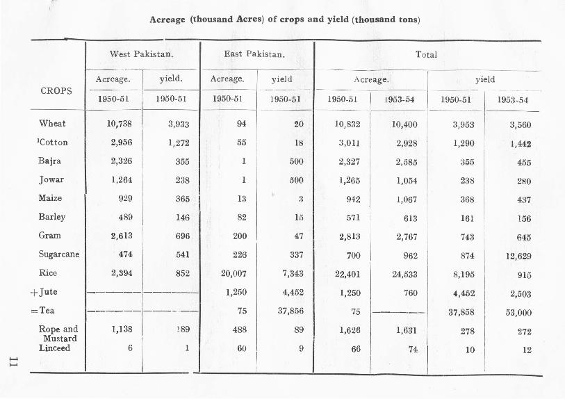
Acreage (thousand Acres) of crops and yield (thousand tons)
'prr
West Pakistan. East Pakistan. Total
Acreage. yield. Acreage. yield Acreage. yieldCROPS ----,-_ .•.- .- -- -- ..-
1950-51 1950-51 1950-51 1950-51 1950-51 1953-54 1950-51 1953-54--
Wheat 10,738 3,933 94 20 10,832 10,400 3,953 3,560
lCotton 2,956 1,272 55 18 3,011 2,928 1,290 1,442
Bajra 2,326 355 1 500 2,327 2,585 355 455
Jowar 1,264 238 1 500 1,265 1,054 238 280
Maize 929 365 I 13,.
:3 942 1,067 368 437
Barley 489 146 82 15 571 613 161 156
Gram 2,613 696 200 47 2,813 2,767 743 645
Sugarcane 474 541 226 337 700 962 874 12,629
Rice 2,394 852 20,007 7,343 22,401 24,533 8,195 915
+Jute ----- ------ 1,250 4,452 1,250 760 .,452 2,503
=Tea ------ ----,--- 75 37,856 75 ------ 37,858 53,000
Rope and 1,138 189 488 89 1,626 1,631 278 272Mustard
Linceed 6 1 60 9 66 74 10 12
I•.....•.....

It will be seen that the distribution of principal crops in the two wingsof Pakistan is of a complementary character. Out of a total 10,832 thousandacres under wheat, East Pakistan has only 94,000 acres. Cool early winterrains and dry and sunny ever summers with plenty of water available forirrigation provide the geographical background for the wheat crop of WestPakistan. It is the principal Rabi crop of the irrigated districts. Similarlycotton is the principal Kharif crop. In the irrigated districts the bulk of it is theimproved American Cotton. It responds very well to a dry summer andjudicious application of water. The physical environment of East Pakistan istoo humid and wet for both these crops. Similarly more than 90% of maizeis produced in the irrigated and well watered districts of Punjab and N .W.F.P.
Bajra, Jowar and gram do well in dry areas and sandy and comparativelyinfertile soils. They are therefore grown in the unirrigated districts ofWest Pakistan with low rainfall. The" area under Jowar and Bajra in EastPakistan is practically negligible and that under gram is less than 10%.
East Pakistan h is about 90% of the rice and all the acreage under jute.Jute is a very exhausting crop but the application of manures is uneconomicowing to its low price. It can stand floods, and is actually greedy for waterright upto the time of harvest. Annual renewal of fertile silt on a very extensivescale, maintenance of high temperatures and good rainfall, therefore, contributeto the heavy concentration of this crop in East Bengal which has been producingabout 65 to 80 p.c. of the worlds' jute. The main jute area is concentratedalong the banks of the three principal rivers, Jamuna, Padma and Meghna onaccount of the availability of fresh water for steeping. Cheap and industriouslabour, requiring hours of standing in water and unsusceptible to the stagnantsmell produced in retting is another important factor.
Similarly, large area flooded every year, existence of numerous Bhilsand swamps, war.n winters and long summers with high average temperatureand good rainfall extending over both early and late summer, pro vide a suitableenvironment in which rice replaces wheat as the principal foodgrain here. It iscultivated all over East Pakistan, excepting the saline coastal areas. Threecrops are grown in a year, Arnan (winter rice), Aus (autumn or summer rice)and Bora (spring rice). This crop is the mainstay of the people. It gives ahigher return per acre for the dense population and its straw provides food forcattle. A small quantity of rice is also grown in West Pakistan where it ismainly distributed in the flooded riverain areas or depress e d Barani or irrigatedareas.
12
Jute is a regulated crop. Due to decrease in exports to India, theprincipal buyer, the acreage under jute has decreased from 2,058 thousand acresin 1947-48 to 1,250 thousand acres in 1950-51, and 760 thousand acres in 1903-54and the yield from 68,42,605 bales m 1947-48 to 4,452,000 bales in 1950-51 and250,3000 bales in 1953-54.
The area under rice has during the same period increased from 19,006,400acres in 1947-48 to 20,007,000 acres in 1950-51 and 24,533,000 acres in 1953-54and the yield from 6,736,200 tons to 7,343,000 tons 91,51,000 tons in 1953-54.This makes the province quite self-sufficient in food as its normal requirementsare estimated at 72 lack tons.
Tea is another important crop of East Pakistan which is not produced inWest Pakistan at all. In 1950-51, it covered an area of 75,000 acres and theproduction was 37,856,000 lb=. while in 1953-54 the production was estimated at53 million lbs. By international agreement its acreage has been fixed at 83,700acres. The hot wet and humid climate of the Sylhet district in the well-drainedsub-montane of the heavily forested Assam Hills, with excellent deep soils richin burnous and iron are very favourable for tea. The slope is sufficient togive good drainage. Tea gardens are found not only on low hillocks or tilaebut have also been extended to reclaimed marshlands though the product of thelatter is comparat ively inferior. The pre-Monsoon or early summer rains, oftenassociated with Norwesters, promote the growth of new leaves. To a smallextent tea is also grown in Chittagong on the low hills unfit for rice cultivation.
Besides these East Pakistan produces almost all the Pakistan's linseedand summer Til. It has an area of about 265,000 acres under betel-nut withan annual production of 9,700 tons. Rape and mustard, sugarcane and tobaccoare the crops which are common to both East and West Pakistan, the first twobeing comparatively more important in West Pakistan and the third in EastPakistan.
Taking the two wings together Pakistan has a small surplus in food crops.There is an explortable surplus of about 300,000 tons of wheat and 150 to 200tons of rice. Of the cash crops in 1950-51 there was a surplus of over 12 lakhbales of cotton and 5 million bales of Jute and 30 million lbs. of tea. Thesefigures show that agriculturally Pakistan is a prosperous country and that thisprosperity comes from the balance maintained in production in between the
two wings.
13

Minerals.A great variety of minerals are found in the mountain region bordering the
Punjab plain more especially in the Salt Range, mountains of Chitral, PotwarPlateau and North Baluchistan, but the quantities so far known are generallysmall and difficult to work. The principal minerals which are being worked atpresent are (1) Rock-salt from the Salt Range at Khewra, Warcha, Kalabagh(Punja~) and Kohat. Its annual production is 7 million maunds. (2) Coalmined from the Salt range at Dandot and Makerwal (Punjab) from Sharigh,Khost, Sor Range, Machh, Harnai and Digari (Baluchistan) and ]himpir-metting
in Sind. The total production is very small, between 5 and 7 lakh tons.(3) Mineral oil produced in the Potwar Plateau, at Khewra, Balkassar, Dhulianand Joyamair. Exploratory drilling is being made at Sui in Bugti hills inWest Pakistan and in Patiya (Chittagong). The annual production of crudePetroleum in 1953 was 15,41,2014 barrels. (4) Chrornite largely mined from HinduBagh in the Zhob valley. Its annual output is about 20,000 tons. Largequantities of gypsum, limestone and sulphur are also found.
Some salt deposits are found in various parts of the plains. In Tharparkaralmost inexhaustible quantities of salt deposits have been located. About 500million maunds of salt is manufactured from sea water near Mauripur where lowrainfall, plenty of sunshine and higher winds are all favourable. The worksare located near the ports. Salt is easy to be exported to meet the requirementsof East Pakistan where the humid climate and long rainy season are unfavourablefor its manufacture for the greater part of the year.
East Pakistan consisting mostly of a newly formed plain has practicallyno minerals. Only near the northern balder and in Chittago ng hills, somedeposits have been found of liginite and oil. Poss ibilities of oil exist inPatharia (Sylhet) and Patiy a (Chittagong).
It will be seen that except for salt, both the wings have to depend uponimported minerals.
Industries :-
Pakistan is primarily an agricultural country. Its industries are mainlyrelated to her agricultural products. Of the 1,432 manufacturing establishmentsin Pakistan in 1949, there were as many as 850 connected with the produce ofthe soil including 210 rice mills, 300 cotton ginning and pressing mills, 58 jutepressers and 110 tea manufacturing factories. The factories are very unevenly
14

distributed between East and West Pakistan. East Pakistan had only 374factories out of the total of 1432. They are unevenly distributed not onlybetween West and East Pakistan but also within the same region. In WestPakistan while factories relating to agriculture products are scattered over therural areae, those relating to non-agricultural produce are mostly located atKarachi and Lahore. In East Pakistan they are mostly located in Narayanganj-Dacca region and Chittagong. Thus while the industrial position as a whole isvery unsatisfactory, there is also lack of balance in its location. Things,however, are likely to improve when the Government policy about thedecentralisation of industry is successfully pursued. This may be achieved bythe development of hydro-electricity for power in various parts for which thereare great opportunities both in West and East Pakistan.
Population :-
According to the provisional figures of the 1951 Census the totalpopulation of Pakistan is 75,842,000 with a density of 208 persons to the squaremile. The population of East Pakistan is 42,063,000 with a density of 777persons, while that of West Pakistan is 33,779,000 with a density of about108.51persons to the square mile. Thus, East Pakistan with only about 15 p.c,of the area has about 66 p.c. of the total population. This shows a great lackof balance in the population of the two regions. In East Pakistan the pressureof population on soil is great. About half of the holdings are hardly sufficientfor the maintenance of the families which own them. In West Pakistan thesituation is much better but there are large areas which are lying waste owingto aridity and other reasons and await reclamation.
While in East Pakistan the population is more evenly distributed it showsgreat variations in the various parts of West Pakistan. In Baluchistan statesthe density falls to 6.9 person per sq. mile and rises to 1387 in the federal areaof Karachi. The old settled districts in the sub-montane region of theHimalayas and the irrigated areas of the plains are comparatively moredensly populated.
15

LAND USE SURVEY OFWARAH AND KOT MANGAL SAIN
BY
Dr. Miss. M. K. ELAHI,
Department of GeograPhy, University of the Panjab.
At a distance of about 1 mile S 5°E from the well known salt mmmgcen tre of Khewra are situated the twin villages of War ah Thal and Kat Mangal-Sain. The site is representative of a broard class of villages located along theline where plains and mountains meet. The position is at the same timeadvantageous and debilitating to the extent of being precarious. Being on thebuffer zone between the contending interests of the Jhelum river regime and thezone of influence of the apparently stationary but in reality encroaching Salt-Range, the villages in certain respects take homage from both and in otherrespects are subjected to the adverse influences from one side or the other.Normally speaking the total populace obtains its living from thetert ile soils of the flood plains of the Jhelum, which flows about 3 miles south-wards from here, and at the same time utilizes the proximity to the mountainsby working in the mines and the associated industries. Under other cir-cumstances there are constant ravages from the mountain side in the form ofthe spread of its debris on the northern fields. The action of the hill torrentsimpair the fertility of the soil by mixing it with coarse gra vel and pebbles ofvarying sizes. Another effect of rain water and runnels though not so much incau sing sheet or gully erosion, is to be seen in the spread of a fine coating ofsalt s dissolved in sufficient quantities in water draining downwards from theSalt-Range. The spread of salt really becomes a problem in the less rainy yearsthan in the rainier ones. In years of small rainfall the amount and flow ofrainfall is just active enough to transport salt from the slopes to the fringe ofthe riverain tract down below. When the rain is not very small in amount thesalt contents are carried further downwards towards the river and the fields ofthe villages concerned receive just enough soil and salt as to be able to reno-yate the fields. It is, therefore, seen that the acreage of Kharaba or crop failure
17

very often synchronises and sympathises with the varying amount of rainfallfrom year to year being on the wrong side in years of scanty rainfall.
In the at sence of any improved means of irrigation the scar-city of rainfall is in itself the m i it important cause of crop failurebut the magnitude of failure"' is determined both by the less amount of rainreceived aud the encroachment of salinity in years of less than the averagerainfall. (18").
The physiography of the small piece of 1,238 acres of land is expected to besimple as it actually is. Still the small undulations on the difference of com-parative levels is in this case of permanent importance not only in fixing theextents of Maira (or the upper land) and Bar ani-awal (the low lying tractsreceiving rain water from the surroundings) but also in determining the verybarrenness or usefulness of land. Two contours of 700' and 750' height areshown on map No.1. The land below 700' is shown in several shades denotingthe classification of land, above it is shown blank indicating that it is ir possiblefor agriculture. With the exception of two very small patches of land each
covered by the 750' contour, the general trend of contours is, roughly speakingfrom west to east with some noticeable adjustments in the trends. The adjust-ments are in the form of the tongues of higher land projecting downwardand the small re-entrant like penetration of comparatively lower land upwards.Therefore the land above the 700' contour is only rising northwards compara-tively less gradually but is undulating in an east west direction as wellBelow 700' contour the slope is gradual to the extent of being imperceptable.It is this flat country which is cultivable and most of it is under plough. Theland to the north of it is, as a block, useless for agricultural purposes. The landof the villages, therefore, has two distinct faces, entirely different from eachother, the one unproductive dreary and bleak, strewn with pebbles and bouldersand coinciding with the fan like dispersal of mountain debris, and the otherproductive, green and smiling corresponding with the northern most limit of theflood plains of the Jhelum.
The co-existence of the villages viz. Warah-thal and Mangal-Sain at adistance of less than half a mile from each other, and located within the confinesof a single unit as treated in the official documents, calls for some explanation.The possibility of over flow of life from one nucleus to ano ther on account ofsurplus prosperity conducive to dispersal of population for want of space inthe parent village of Warah is ruled out of order at the very outset. In factthe case is neither too much prosperity nor just the congestion of space but
18

actually the limitations of resources has been the impelling force behind theseparatist move of a section of village population to a new abode which wasaway from the plains and was more near to the mountains As in some othercases, similarly in this, the mountains offered better prospects than the plains.The salt mines acted as a powerful magnet. Later the establishment of indus-tries like the I.e.!. factory increased the functional importance of Kot MangalSain, It grew in size at the expense of the surrounding settlements livingon the resources of soil which were meagre. The declining town of PindDadan Khan is also understood to have made its contribution towards the
growth of the village.
The narrow ribbon llke shape of the built up area along the two sides ofthe road and its comparatively new buildings with a total absence of old onesproves the infant character of the settlement. On the other hand its locationon the fan like outgrowth of mounta inous debris which is altogether barren goesto prove that majority of its inhabitants are workers in the mines and in thefactory. This inference was fully substantiated by the results of personalinvestigations from as many people as could be contacted. The average- dailyincome of an average family of five, is Rs. 3/-. A few people are engaged in thedefence services of the country and equally few are running small shops in thevillage. In this village inspite of the small per capita income of the inhabi-tants people are not indebted, the reason being that there are no money lendersin the village. The absence of money lenders is specially noticed after thepartition when Hindu Banias migrated to the other side of the border. Therehas since been no formation of capital and its concentration in a few hands.The inhabitants are poor but still many are better off as compared to the other
village folks in the neighbourhood who are poorer still and whose only occupationis agriculture which is subjected to the law of diminishing returns than
industry.
Along with these advantages of the site of Kat Mangal Sain it suffers atleast from one serious disadvantage. It is that of the non-availability ofdrinking water. The water table is too low to allow the sinking of wells andthere if a well is sunk at great cost, its water may be brackish. There is there-fore not a single well in the neighbourhood. Water is brought from tne I.e.!.factory in pitchers or in drums on reris, donkeys, etc.
The inhabitants of Warah village are partially labourers and partiallyagriculturists. The number of working agriculturists is 193 with about 792dependent s. The entire agricultural land belongs to the residents of Warah
19

and not of Mangal Sain. All the area covered in this land-use survey belongsto the Warah village except for the built up area of Kat Mangal Sain which isbout 30 acres only. The method of investigation was partially direct study ofconditions on the spot and partially based on the study of official sources ofinformation. This information is contained in four books named M isle-H aqiyat,Jama Bandi, Kh.aera Gardawri and Lal-Kitab and a village map giving thedemarcation of fields and built up areas. Misle-Haqiyat and Jama-Bandi dealwith the ownership of land, the first giving the details of ownership before 1940,the year of last settlement and the latter giving the changes which have takenplace since then. For the purpose of land use, these are not of much avaiJ asthese only convey an idea about the sub-divisions and fragmentation ofholdings. Khasra-Gardawri gives detail of farms. Lal-Kitab is the mostinformative of these all. It contains information about the usage to which landis put taking the village as a whole. It is split into two parts. The first partgives the classifications of land in different years under such headings as totalarea, area under forests, land otber than forests divided under the subheads of
(a) impossible (b) cultivable, and cultivated further subdividedinto kinds of land, fallow, double cropped area etc. The second part givesdetails about the acreage sown to the various commodities in Khar if and Rabi indifferent kinds of land e.g. Chahi, Hail, Barani, Barani Awwal, Miara and Rakkar.Chahi means well-irrigated. HaiJ is the land adjoining the village and enrichedby the village waste. Barani Awwal is flat low land receiving the rain water ofthe surrounding area. Maira is the upland receiving direct rainwater only andRakkar is the stony and undulating land consisting of coarse material.
The classification of land in Warah village is as follows :-
Out of the total of 1,238 acres, 750 acres, as high a percentage as 61, istotally denied to agriculture and comes under the category of impossible forcultivation. About 488 acres 39% is under plough. Out of the cultivated land,Hail covers 6 acres, Chahi 18, Barani Awwal 223, Maira 232, and Rakkar 9,the respective percentages being 8.7%. Lx, 45,48-8 and 1.9. It is clear thatHail, the best land, is very small. Chahi being another prized kind of land isagain very limited. The number of wells in the village is only three, onesupplying the drinking water for the village folk, and the two irrigating thefields. The restriction on the number of welJs is not imposed by the depthof the water table which is only 20 ft. here but by the fact that wells go outof usage after some time owing to the increased brackishness of water. Maira
20

--,~CL,\SSIFIC,\TIO. •Of' LAND .
WMAH & MANCAL SA~
I ~,
•.~,IUlll AR["
\JffIW~~llilll\,v(1 \ \
I

accounts for the greatest acreage with barani following it. Withjn the cul-tivated area gravely patches are small.
Th~ distr ibntion of various types of lands on the map shows that theland unfit for the cultivation is mostly found in the nor th. It has beenrendered useless by submontane deposits. Rakkar which also contains piecesof stones and pebbles is near it on its southern margin. Maira occupies themiddle zone of the small acreage in south eastern corner. The plain area of thevillage is not without slight undulations although the slope is ;ery gradual, themiddle portion of the village land is slightly higher. Chahi and Hail instead of- /encompassing the village site as it usually happens, are found to its south, thenorthern area being useless. Barani Awwal predominates. It is found in twobig blocks spreading east-west, one located to the south of the village site andthe other covering the southern parts of the village area. A strip ofChahi land in the east almost connects the two blocks.
The total area sown for the 5 years ending 1953, is 408, out of a totalof 48l being left for the period, 73 acres being left fallow. The percentage offallow land, therefore comes to 15. Double croppmg was practised on 17acres on an average. It is about 3.5% of the cultivated land. Mostly therich and well watered chahi land is double cropped with only small share ofBarani Awwal, Map No.2, showing t he distribution of single cropped anddouble cropped land for the year 1952-53, portrays a slightly different picture.The difference lies in the extent of double cropped land which shows adeparture from the average in a positive direction. The distribution of thedouble cropped land is still in keeping with the average conditions that itmostly coincides with chahi land. There is one patch of double croppedland in the middle of the map which is on Maira.
The average acreage under crops which were matured is only 379, out ofa total of 424 including double cropped area and the land_ left fallow giving 54acres of Kharaba crop failure. Though average percentage of Khar abais calculated at about 13 which is high may be not too high in viewof the general environmental conditions. On the other hand it rises,very considerably in bad years. For example in 1952-53 out of a total croppedarea of 444 acres 119 acres turned to be Kharaba giving the percentage to beas high as 27. It is this phase of the agriculture of Warah which demands aa serious consideration. It is the out come of a least of variants which awaitfuller investigation and appropriate cure. A study of crop failures from yearto year and its comparison with rainfall data show the relationship betweencrop susceptibilities and the vagaries of rainfall.
22
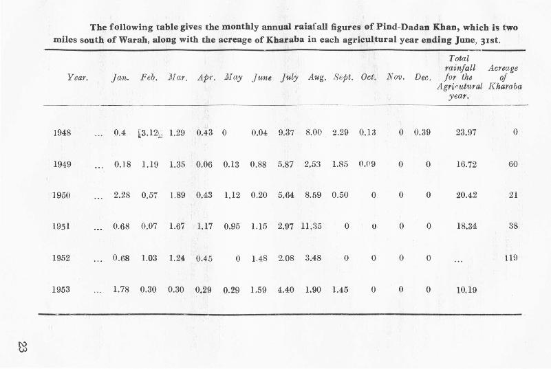
The foflowing table gives the monthly annual raiafaU figures of Pind-Dadan Khan, which is twomiles south of Warah, along with the acreage of Kharaba in each agricultural year ending June, 31st.-
Totalrainfall Acreage
Year. Jan. Feb. ~lJar. Apr. Nay June July Aug. Sept. Oct. Nov. Dec. for the ofAgrirutural Kharaba
year.
1948 ... 0.4 l3.12k,j 1.29 0.43 0 0.04 9.37 8.00 2.29 0.1;3 0 0.39 23.97 0
1949 ... 0.18 1.19 1.35 0.06 0.13 0.88 5.87 2.53 1.85 O.f19 0 0 16.72 60
1950 ... 2.28 0.57 1.89 0.43 1.12 0.20 5.64 8.59 0.50 0 0 0 20.42 21
1951 ... 0.68 0.07 1.67 1.17 0.95 1.15 2.97 11.35 0 U 0 0 18.34 38
1952'" 0.68 1.03 1.24 0.4.'5 0 1.48 2.08 3,48 0 0 0 0 119
1953 '"1.78 0.30 0.30 0.29 0.29 1.59 4.40 1.90 1.45 0 0 0 10.19
~

The variations in the amount of rainfall have a great bearing on theamount of Kharaba. Kharaba is less in the years 1948-49, 50-51 and 1951-52,when the rainfall received was adequate and well distributed for thecrops amounting to 0,21 and 38 acres giving a positive correlation with thetotal rainfall of 23.971/, 20.421/and 18.341/being least in 1948-49 a year of mostabundant and well distributed rainfall.
Land going out of use for cultivation is connected with rainfall changesfrom year to year but the correlation effect of the accumulation of salts is morefelt in some years than in others. The land is gradually being deterioratedbut cultivation goes on with diminishing returns till a point is reached whenit becomes untenable. This is borne out by figures under the head Digar-Banjar or other uncultivable waste, which spread over 80 acres in 1948-49with 75 acres of Banjar Qadim (old uncultivable waste) and 5 acres as Banjar-Jadid (New uncultivabe waste). In the year 1949-50 it was reduced to 55with 51 as Qadim and 4 as Jadid. This reduction is not understandable asit appears that there is something wrong with the 1948-49 figures. It thenremains 55 acres, upto ]91>1-52. On the year 1952-53, there is a substantialincrease from 55 acres to 133 acres with 78 acres as Banjar J adid which ismore than the total previous acreage of culturable waste. Perchance thisis the year when the acreage of Kharaba also increased abnormally. The
explanation may be sought in deficit rainfall in that year which resultedin the increase of the salt content in the soil rendering a part of theculturable waste unfit for cultivation and at the same time effecting thestanding crop.
As usual, there are two main harvests in the year, Rabi and Kharif.Being a bar-ani land Rabi is more important crop than Kharif. In the year1952-53, the year of Survey, 285 acres of land were sown to Rabi crops and 225to Kharif. Products of Rabi harvest are only three viz, wheat, barley and TaraMira. Barley and Tara-Mira cover very small acreages, wheat accounts for 282acres and barley and Tara Mira for 1 and 2 acres respectively. Almost the wholeof chahi land is sown to wheat. Again 4 out of 6 acres of Hail is under wheat.
ThE'!greatest acreage of wheat is in Barani Awwal accounting for 53%of the acreage, Maira for 38.5 chahi for 7 and hail for 1.5% Neither wheatnor even barley is sown in Rakkar Land. Barley is mostly grown on BaraniAwwal. Tara Mira is grown on both Barani and Mair a. Map No.3, bearsout these relationships with an additional information that the wheat landsof the village are mostly spread in one big continuous block and two or three
24

small patches. The small area under barley is not far away from the villagebut Tara Mira farms are located at the farthest southern end of the villageland probably showing the indifference of the cultivators towards animportant produce.
Wide spread s.ivings of Rabi take place when the rainfall in autumn isabundant to supply the moisture for the germination of seeds. During the autumnof 1951 (August-September) the rainfall eceived amounted to 11.35" and theacreage put under Rabi increased to 360 acres. Similarly during the autumnof 1948, the amount of rainfall in August and September was 10.92 and theacreage under Rabi was above the average. In the years of scanty rainfallduring autumn the acerage under Raoi crops decreases as in the case of 1950and 1952 with 240 and 283 acres respectively. Fields of wheat are also highin accordance with a well distr iouted and fairy adequate winter rainfall.Yields were high 7-8 maunds per acre in 1950 as the amount of rainfallduring November, December, January. February and March was about 5//,
while in the years 1951-5~ and 53 YIelds have been quite low, 4.5 maundsper acre on the average.
Kharif, though less important than the Rabi crop in the area, includesa greater number of commodities uiz, J owar, Gowara, Cotton (Desi) Swank,Moth and Fodder crops. Out of the total Kharif crops Bajra accupies thefirst position covering 148 acres. Gowara comes next with 30 acres underit. Chari and Jowar are given 26 and 17 acres respectively. Cotton desi,Moth and Swank are grown in very small quant it ies on 1, 1 and 2 acresrespectively. In this way 66% at the land in Kharif is sown to bajra, 13%to Gowara, 11% to chari and 7% ~o Jowar, others being negligible. Bajra,the most important product of Kharif is mostly raised on comparatively poorland of Maira covering 93 acres, more than 50% of its total, the stillpoorer land, Rakkar is almost wholly under Bajra, the only crop taken fromthis land in a year. Due to its acceptability to the poorer type of landstony soils like Rakkar which otherwise would lie waste, can yield some crop.Some Bajra is raised on Barani Awwal, occupying about 32 acres.
Gowara and chari are mostly grown on Maira and Barani lands.Cotton requires comparatively better soil and irrigation facilities under suchdry climatic conditions. There being no arrangements for irrigation exceptwells which are two in number and cater for very small areas, cotton inspiteof its cash value is raised only on 1 acre of chahi land. Similarly there is a
25

totai absence of rice, maize .md sugarcane. Jowar being more water lovingthan Baj ra, is aiso limited in acreage and is mostly grown on chahi andBarani land.
Map No.4 shows that there is a good deal of dispersal of land underdifferent crops. It appears that excepting Jowar, other crops are ratherindifferent to the types of land. A comparison of maps No. 3 and 4 showsthat Rabi and Kharif crops are grown on different lands. No such thing asscientific crop rotation is practised -in the village. file application of manureto the land is negligible as due to the -dear tn of water supply fodder cropsare not grown to any -extent and there are hardly about 50 cat cle in the wholeof the village to supply the cow manure. F arrners being generally poor aswell as lacking inertia do not manure their fiel-ds properly.
The average size of holdings in the case of the owner agricultur ists, is4.5 acres while the tenants' holding is less than half all acre, unlike thegeneral conditions elsewhere in the Panjab. Variations do exist from thelargest 'holding of about 27 acres to smal1est in the village, being t or about 5marlas in the case of the tenants. Without turn of 5-6 maunds of wheat mgood years and of 3-4 maunds in bad years a remar-kable absence of cashcrops and very little market gardening on Hail and chahi land only the averageholding is obviously an uneconomic unit. It is but obvious that these tenantsseek work in the mills besides tilling small patches of land. Some of toe agricul-tural problems peculiar to the village are:
1. Spread of mountain debris. It can be arrested by throwingtemporary bunds on favourable points in the course of torrents rather awayfrom the foot of the hills as t here the velocity of water may be too greatfor the loose -bund and instead of Checking the spread of water and thespread of its load it may itself be swept away. Such a loose bund will neverbe a complete barrier for a long period of time so as to allow the formationof the reser-voir of water above it, thus increasing the danger of floods in casesof the usual freshets. It would rather serve LO check the onflow of coarsedebris on to the fields and divert the flood waters on to the waste land.
2. General aridity of climate and specially the variability of rainfall(winter rainfall specially) with almost no provision for irrigation.
3. Spread of Kallar with the 'resultant increase in Banjar Jadid.One coating of white efflorescene on the surface is a general menace to thelands of the district lying almost midway between the foothills and the
26

WARAH & MAt-K;AL _ ' IN
I""""'''''''''',·S""I.t:C~.'It •• J
SINGlE C"OPI"U{1.iwt)
IUk.T ,utA
MAPNQ J \ I ..SINGLE ANI> J)()lJI'.t-: GROPP ,I) AllE.,\S
" •.•.•••. " ,," >0> .""

stream of the Jhelum. In Warah on the fringe of the riverain tract, the problemis actually less serious. The best solution for the last mentioned problem lies in theconstruction of tube-wells which may supply water for irrigation and help tocheck the spread of Kallar. Malakwal is 12 miles from Khewra and is a stepdown grid sub-station (132 kw) of the Rasul hydel power, secondly the proposedline from Rasul to Bhera Kalra, Shahpur etc, almost clings to the left bankof the Jhelum. The tract of land on the right bank of the river is not served.In fact the whole area of the district of Jhelum lying between the Salt-Rangeand. the river is a victim to the Kallar which can be reduced effectively by theextent ion of the hydro-electric transmission lines on this side of the riverand the sinking of tube-wells consequent upon it. In case ot' Warah, power06n be obtained from the thermal power station of Khewra although it shallbe more expensive.
The land in general is not poor but thirsty and if proper arrangementsfor the water would be made, the growing population of the twin villages~y aceommodate themselves on the village land.
28

THE ECONOMICS OF POWER CULTI-VATION FOR WEST PAKISTAN
BY
SIR WILLIAM ROBERTS, C.I.E.
Present Position.·- West Pakistan had probably less than 2000 Tractors on31st December, 1951 and of these 1500 have been purchased since partition.The country is purchasing roughly one tractor a day now.
Culturable Area.-West Pakistan is cultivating about 26 million acres perannum mostly by irrigation. There is an enormous area which is cultivable butis now lying waste owing to lack of water and of suitable means of cultivationestimated at 75 million acres as follows ;.-
Cultivated.N.W.F.P. 25,00,000Punjab 1,71,00,000Bahawalpur 20,00,000SiJ:d 5700,000Baluchistan 4,00,000
Or her State, tribal areas figures not available.
Total 2,74,00,000
Uncultivated.59,00,000
2,00,00,0001,06,00,0002,44,00,0003,45,00,000
9,55,00,000
Area under Fodder.-In the Canal Colonies of the Punjab and Bahawal-pur where cultivation is from UO% to 110% (as in Lyallpur on the Lower ChanabCanal) the area grown with fodder for working animal averages 15% to 18%.The best land is generally put under fodder as the tenant does not have to sharethe whole of this with the Landlord and he also likes to manure such areas withwhatever farm yard manure he can spare. In addition the cattle eat most of thewhea t bhusa and gram bhusa or straw and also some of the gram pulse andpossibly some cotton seed cake. Under compltte mechanisation assuming 300acres is controlled by a Tractor of 25 H.P. to 35 IIP. there would be neet for apair of cattle per 100 acres only instead of 8 pairs per 100 acres as at present.It it safe therefore to state that 15% of the cropped area would be free forwheat, gram, oilseeds and cotton under a mechanised system of farming.
29

Cost of Tractor Cultivation.-It is reckoned that cultivating with a Tractorusing a Cultivators or Disc plough and doing the work better than a pair ofbullocks would be about Rs. 5 per acre whereas bullock cultivation would costat least Rs. 8. If slow speed Light Diesel Tractors are used the cost would beunder Rs. 3 per acre. There is no doubt Tractor Cultivation is cheaper thanbnllock cultivation so long as wheat prices are over Rs. 5 and cotton overRs. 15 per maund.
Displacement of Labour.-It is reckoned that on a unit of 300 acres withTractor Cultivation we would require at most 12 men instead of 36 employedwith bullock cultivation. This means a very serious displacement of labour ortenants and hence the use of Tractors on settled areas must be very gradual.The excess labour can gradually be absorbed by industrialisation, -but thisproblem is a serious one.
111echanisatior; by Co-operative Societies.--It IS sometimes argued that insettled areas the best way of mechanising is through a (a-operative Society ofFarmers. If 20 tenants owning of cultivating between them a unit of 300 acresdecide to co-operate, they can keep a 25 H.P. to 35 H.P. Tractor fully occupied,but there will be no work for at least 66% of them as 33% can easily do all thatis necessary except at harvest time and cotton picking time when more tem-porary labour is required. Only one out of every eight pairs of bullocks willneed to be kept, so excepting for milking cows or buffaloes very little fodder isrequired-say at most 20% of the cropped area. Thus the increased croppingunder cash and human food will be 100/85 X 13= 15'3% increase. It may bepointed out that in other mechanised countr-ies ego in U. K. the horse is com-pletely eliminated. In the early stages of mech auisat ion in Pakistan it isadvisable to keep one pai. uf cattle ptr 100 acres for miscellaneous levelling,sowing smail vegetable pluts and other iuiscellaneous works.
Other advantages of mechanization.
1. Saving of water in irrigation. As in a block of 300 acres the cottoncrop will be generally in large blocks the irrigation water will be running inchannels in the crop and losses by percola tion are sa ved.
2. The cultivation is better than that done by bullocks and occasionaldeep ploughings even once in 2 or a years gradually improve fertility.
3. Operations can be done in time. It is possible to work a Tractor24 hours a day if necessary. In the case of wheat harvesting this often leads tosaving of grain from shedding.
30

4. Weed control is better. Persistent weeds such as Dabh can be moreeasily controlled with a Tractor than with bullock culture.
5. Spraying is more feasible with Tractors and losses from white fly andJossids in cotton can thus be reduced.
6. Surplus water in April and May can be utilized. At present water islargely wasted between end of March and end of May in the Punjab and from15th March to 15th May in Sind. The harvest is then on and the cultivator isbusy. With the Tractor however it is possible to sow green leguminous manurecrops such as Guara Sann Hemp etc., which increase fertility if ploughedin later.
Erosion.-Very large areas in Rawalpindi, Attock, Hazara, Gujrat andmany other Districts are suffering from erosion through sudden floods from HillStreams. Altogether about 2 million acres are affected in this tract alone.The damming of streams by Track Diesel Tractors and the cultivation of exten-sive unirrigated areas is very much cheaper by Light Diesel Tractors than byBullock and human labour. The whole of Pakistan would benefit from largescale work of this nature. This development would create openings forlabour.
New Canals.-In the Thal and in Lower Sind Barrage if land was givenout for tractor cultivation the area could be developed very quickly and coststo Government would be much less than by ordinary colonization. This alsowill create quickly much scope for new labour. Such mechanization 011 say500000 acres in Thal and one million acres in Sind Lower Barrage would require4500 Tractors and would quickly add to the resources of West Pakistan.
As the basis of this paper is related to actual comparative costs ofTractor and Bullock cultivation Some detailed calculations are given below:
Cost of Mechanical Cultiuatio s. as cumpared tu Bulluck Power.-Tllefollowing 3 Tractors have been exhaustively compared:
(a) Drawbar H.P, Fuel.34 Power Kerosine.33 High Speed Diesel.35 Light Diesel
(Crude Oil).
Note :-Powerine costs 1/10 per gallon, High Diesel 1/2 & Light Diesel(Crude Oil) -/8/-.
Tractor,ABC
Nu. of Cylinders.241
R.P.M.900
1350540
It will be noticed that the H.P. of these three is nearly equal.
dl

WORKING COSTS pER HOUR
ABC
Rs. 4 II 6Rs. 4 6 5Rs. 2 7 0
Labour and overheads workingon average 80 hrs. expensess». 200 p.m.
Rs. 2 8 0Rs. 2 8 0Rs. 2 8 0
Total.(b) Fuels, lubricants, repairspares and depreciation.
Rs. 7 3 6Rs. 6 14 5Rs. 4 15 0
Depreciation of implements.Three types of cultivation is done viz.
(c) (a) Harrowing 3// similar to bullock ploughing.(b) Disc Tiller ploughing 5" or 6".(c) Cultivator 5" to 7".
Depreciation: Harrow -/6/- per hour.Disc Tiller 1/-/-""Cultivator -/6/-""
The working cost per hour of these Tractors will be:A. B.
(d) 1. With Harrow Rs. 7 9 6 Rs. 7 4 62. With Cultivator Rs. 7 9 6 Rs.7 4 63. Disc Tiller Rs. 8 :-l 6 Rs. 7 14 6
The above represents full costs per hour assuming 8,000
C.Rs. Ii 5 0Rs.5 5 0Rs.5 15' 0
to 10,000 hourslife.
(e)
(j)
The output per hour is as follows :-(a) Harrow 2 acres per hour.(b) Cultivator 1.2" "(c) Disc Tiller 1.1 " " "The cost per acre is approximately as follows :--
Implement. A (Powerine). B (High SPeedDiesel).
Rs.;} 10 3Rs.6 0 0Rs. 7 3 3
12 95 38 0
C (Luw speedDiesel).
Rs.2 10 6Rs.4 7 0Rs.5 6 4
H.P.
34:3335
Harrow Rs.3Cultivator Rs. 6Di~c Tiller Rs. 7
Cost of bullock cultivation.One pair of bullocks for 2 days @ Rs. 2/8/-One labourer @ Rs. 1/4/-Depreciation and interest
Rs.5 0 0Rs.2 8 0Rs.O 8 0
Total Rs.8 0 0Many claim bullock cultivation costs Rs.!:l or more per acre in West
Pakistan.
It will be seen from this comparison that Tractor cultivation costs lessthan half bullock cultivation when the Harrow is compared with bullock plough-ing. It may be noted also that the Crude Oil Tractor is the cheapest inoperating costs. Cultivation with Disc Tiller or Cultivator is much superior to
32

bullock cultivation and costs are not comparable. While the calculations for'Tractor work can be regarded as accurate, there is room for argument regardingthe actual cost of bullock cultivation. Another way of looking at it i'l asfollows: Assuming 12t acres of irrigated land per pair of bullocks and that fiveoperations per acre will represent the total cultivation this means 62.5 acresploughed or cultivated or sown per pair. It is sometimes claimed a pair ofbullocks will plough an acre a day-if so the animals are working one day insix only. It is here assumed 1- an acre a day is normal and one day in three ofcul tivation. One acre of Kharif fodder and one acre of Rabi will be consumedby the cat tIe and this @ Rs. 20 a Kanal = Rs. 320 per pair. Add carting andlabour in cutting and in feeding the animals we can add -/8/- per day-vor Rs. 175per annum. Wheat Bhusa-50 mounds @ Re. 1 & 10 mds Gram bhusa @ -/8/-Rs.55. Concentrates estimated @ 20 seers per month @ 7)-/- a mauud costsRs. 42. The total comes to Rs. 550 which if debited to cultivation only comesto approximately Rs. 9 per acre, The cattle, however, do some carting of grainfrom the Threshing floor to the village and some other occasional jobs, so thefigure of Rs. 8 per acre calculated above is not far wrong.
There is no doubt that mechanisation would increase the food supplyand cash crops by at least 15%. This is an automatic increase quite apart frombetter yields as pointed out above.
Cost of mechanieation.:-: Taking a unit of 300 acres for a Powerine Tractorof 25 H.P. to 35 H. P. the total cost of mechanisation will be about Rs, 21,000or Rs. 70 per acre. Recurring expenditure will be round Rs. 7,000 per annum.
Use of Poiaerine Tractors in uncultivated Areas.- The vast areas nowuncultivated in West Pakistan representing as it does at least 3 times thecultivated area should nut be neglected. In most of this area the rainfall is only5// per annum but even so it carries some natural bushes and grass which flourishafter rain and give considerable grazing and fuel. With a fast moving PowerineTractor it would be bossible to greatly increase the number of bushes and grassesby quick cultivation and showing of seed. Plants suited to arid conditions areavailable in other parts of the world and a systematic effort by Governmentcould d) an enormous amount in increasing our resources for feeding of sheep,goats and camels.
References :--(1) Paper by Author at Pakistan Science Congress 1950.(2) Tests of Tractors at Isakhel Estate, Kotsamaba [Baha-
walpur State) through courtesay of Sirdar Ghazanfar-ullah Khan.
33

INDUSTRIES IN THE MIDDLE EAST*BY
Miss YUSAF KANIZ
Lahore College for Women, Lahore.
Industry has acquired an overwhelming importance in the world of today.Industrial development depends on the resources of a country in power, rawmaterials, means of communication and not the least on the out look of itsinhabitants in the matter of education, labour and capital. With the rapidreorientation of the politics of the Middle Eastern countries greater attention isbeing paid to the utilisation of their natural resources for the purpose ofindust rialisation and a better economic set up. Still, the progress made bythese conntries during the last thirty years is not much as is evident from thefact that mearly 10% to 15% of the population derives its livlihood fromindustry and of this total a considerable proportion is engaged in cottageindustries. This slow progress is due to :-
I. Scarcity of fuel.Deficiency of power and especially the paucity of coal is a serious
hindrance. Turkey and West Pakistan possess a small quantity of coal whichis poor in quality and uneconomical in use. Turkish coal, 26,23,315 tons, foundin Eregli-Zonguldak-Amarsa region is of bituminous and sub-bituminous qualitybut lack of labour, poor communications and fragility of the material are thefac tors unfavourable for its proper exploi tation. The last factor is a serioushandicap. It results in considerable waste. Out of a total production of38,31,000 tons only 25,26,000 tons is saleable. Plans are under consideration toimprove this state of affairs. At Kutahya lignite deposits occur, which theTurkish Government has begun to utilize for generating electricity. WestPakistan coal from Dandot is Sub-bituminous in quality but the output isdecreasing. Baluchistan has small deposits scattered over a large area but theycontain a considerable admixture of phosphates, moisture and some volatilesubstances. Total annual production is 266,115 tons. Iran produces some
*In this article West pakistan is considered to have peen included in the Middle East.
35
150,000 tons of coal per year mined under Government Control. Totalproduction of both the countries (Iran and West Pakistan) is decreasing.
As regards production of petroleum, Middle East comes next to U.S.A.but most of this fluid wealth is exported as it is exploited by foreign nationswith foreign capital. Only 1-3% is consumed locally, mostly in motorcommunication. It is only Egyptian oil from Ras Gharib fields that is retainedwithin the country to satisfy 40% of its needs. Syria, Lebanon and Palestineuse Iraq oil for the electrification of important cities.
Development of electric energy is impeded by a great deficiency oftechnical labour and capital. In the absence of heavy industry, electricalmachinary (generators, turbines etc.) has to be imported. Hydro-electric poweris little developed because of lack of fuel and water for coaling purposes. Evenin thermal plants copious quantities of water are essential for the generationof electricity. Turkey has been able to develop nearly 35% of her potentialhydro-electric power. There are six projects each with an installed capacityof 4000-7000 K.W. They are scattered in the marginal areas of the Anatolianplateau. They are:
(1) Sizir Project in Sivas and Kayseri area.(2) Tortum Project in Erzerum.(3) Golcuk Project in Elazic mines.(4) Goksu Project in Konya.(5) Degirmendere Project in Teabzon.(6) Kadincik Project in Taurusand Adana.There are three multi-purpose projects connected with irrigational and
flood control works located at Sariyar, Gediz and Buyuk Menderes.
Iraq has not tapped her resources of hydroelctric power in Tigris andEuphrates. She relies on cheaper means, that is, oil and gas. Thermal diesalplants have been installed in Baghdad and Basra with an annual capacity of51,000 K. W. The Iraq Petroleum Company has a plant at Kirkuk generating14,000 K.W. of energy. [here are also small plants in various other places.
In West Pakistan there are five hydro-elctric projects(1) Malakand producing 20,000 K. W. per year.(2) Warsak producing 90,000 K.W. per year.
(3) Dargai producing 15,000 K.W. per year.(4) Renala Khurd N. A.(5) Rasul producing 36,000 K.W. per year •
.36

Fifteen thermal and two diesel plants. Total production is 70,000 K.W.against an estimated maximum production of 5-6 million K.W.
The Nile waters at Aswan Darn have been utilized for hydro-electricpower in Egypt and middle Jordan waters in Palestine. In lower Jordanproduction of thermo-electric current s from solar heat is another sourceof power.
II. Nature of Raw Materials.
There is an absence of raw materials for heavy industry except in Turkey,which possesses workable iron deposits at Carndag Torbali and Divisik andnewly investigated reserves at Farasak. Hasan Celebi Elbistan and Cagalayikwith a total production of 144,909 metric tons at present. Turkey rankssecond in the production of chromium 117,975 metric tons per year. Deficiencyof iron ore is serious enough to retard the growth of subsidiary industries.Housing material and mineral salts are found every where in abundance.Limestone,l5ypsum <IS well as sulphur, phosphates, sodium salts, zinc, lead,asbestos and other minerals are available. It promises a bright future for thecement and chemical industries.
Pastoral and agricultural raw materials are available in surplus quantitiese.g., mohair and merino wool of Turkey, cotton of Egypt, West Pakistan, Iraqand Turkey and Silk (in small quantities) of Mazandran in Iran. Hence thereis a good scope for t ext ile industry and efforts in this field have been crownedwith some success. The middle East may well compete with other countriesin textile goods in home as ~ell as foreign markets.
III. Labour.
Compared with their potential resources of industrial raw materials, theMiddle Eastern countries are under populated. The standard of living beinglow, labour is cheap but due to illiteracy it is suitable only for cottage industry.Factory industry lacks technical and high engineering skill and the schoolcurricula lay little emphasis on practical training.
IV. Capital.
Capital is pons asinorum for the Middle East. There has never been aneffort tor raising it. The tragedy is best seen in the oil exploitation of Iraq,Iran and West Pakistan. To overcome this handicap, Turkey and Iran have
37

embarked on a policy of state capitalism and in other countries special conces-sions have been given by the states to private enterprise. Yet conditions are
hanging in the balance.
V. Means of communications.
Means of communications are limited and under developed. In Afgha-nistan, Iran and Turkey topography is a great hindrance. In West Pakistan,Iraq and Egypt, fuel deficiency impedes further rail and rea-l construction.The mileage in various countries is as follows:
Country Railways RoadsTurkey 4,748 25,543West Pakistan 5,362 566,000Egypt 5,235
Iran 1,748 17,(,00Iraq 1,555 4,000
West Pakistan and Turkey have the largest rail and road mileage. EVenin those countries mining centres are far apart which raises the cost of mineralproduction for industrial centres.
With such limitations industry in the Middle Eastern countries attain amodest success in home markets but machinery and certain other capital goodswill have to be imported from abroad. Certain raw materials for localizedcottage industry may also have to be imported for years to come.
Now we may discuss industry under two headings:1. Factory Industry ..•2. Cottage Industry.
FACTORY INDUSTRY
There are five major types.1. Iron and steel industry.
2. Textile industry.3. Cement industry.4. Chemical industry.5. Universal type of industry.Iron and Steel Industry.
It has been seen that among all the Middle Eastern countries it is onlyTurkey where raw material for iron and steel industry is favourably found. In
38

1943, the state installed an iron and steel plant including 42 coke ovens atKarabuk with 30,000 tons' annual capacity, one open hearth furnace having anannual production of 150,000 tons ingots, three rolling mills and one plate mill,the annual capacity being 110,000 tons of steel. The five year plan inauguratedin 1946, aimed at increasing the output. One new open hearth and one electricfurnace have been built along with an iron foundry and forge shop. Totaloutput is 59,332 metric tons of pig iron, 90,786 metric tons of steel, 78,446 tonsof rolled steel products, 8,592 tons of pipes and 314,762 tons of coke. Basedupon this iron and steel, there are subsidiary industries preparing agriculturalmachinery, automobiles and aircrafts. As the total production is small, mostof the machinery is imported.
Light engineering and metallurgical industries have been developed inEgypt Iran, Turkey and West Pakistan with a view to produce light armaments.It is significant that the largest single industrial plan in Iran, after theAnglo-Iranian oil installation, is the state Arsonal. A similar trend exists in
other countries. Local industries are confined to breach loading guns, machineguns and amunition. Heavy armaments Iike tanks, bombers and fighteraircrafts and naval equipments have to be purchased from abroad.
Turkey leads in the number of metallurgical and light engineering
industries. They are private owned and produce iron and steel wires, tools,stones and an indeterminate quantity of other products. In Iran is a blastfurnace in the province of Mazandran, but it is not working to its full capacity.With imported iron bars and steel plates some light engineering works are beingcarried on. Iraq is now producing 5,000 tons of steel scrap per year. It isproposed that a small hand operated mill and an electric melting furnace shouldbe set up to convert this scrap into bars, window shapes etc. which are in 'gceat'demand. The site recommended is Baghdad so that the power problem may besolved. In West Pakistan iron and steel works are centred in Lahore andKarachi. There are two electric furnaces in Lahore producing 300,000 tons ofsteel which is imported semifinished. There are 29 rolling mills with a totalcapacity of 70,000 tons per annum, 35 foundries and 53 small engineering plants.Moghalpura Railway workshop is the most important concern. Two smallmills are under construction in Karachi. In Palestine there is a rail way repairshop and small-scale production of spare parts of electric batteries andhousehold implements. In view of the difficulty of obtaining cast steelreplacement parts, Cairo Tramway Company constructed a steel furnaceelectrically operated and produces 20 tons per month of steel castings.
39

TexthelTextiles may be called the most ancient industry in the Middle East.
The comparatively important position of textiles is due to two reasons; firstlyavailability of raw materials and scondly a large home market. At present alarge number of mills are engaged in ginning and spinning processes. Weavingis hindered by lack of machinery and technical skill. Under present economicdevelopment schemes textiles are being given due attention.
Turkey has made a judicious use of available resources. At presentthere is no need for further expansion, except in production of low pricedstaple and basic materials. There are 12 cotton mille five state owned; 11woolen mills, 5 state owned; and two silk mills. Private mills are confined tocotton growing areas e.g, Izmir, Adana Tarsus, Mersin and Istambul. Stateowned factories are situated farther inland ~at Kayseri, N azilli, Eregli Malatyaand Bakirkoy. Bursa, Izmir and Istambul are the chief wollen manufacturingcentres. Bursa is also noted for mohair and silk weaving. Small silk factoriesare also found at Istambul and Izmir. Total production is 241,758,241 yardsof cotton cloth and 7,692,307 yards of woollen. It is enough to meet the localdemand except in big cities where cloth of high value is to be imported.
Another country approaching self sufficiency is Egypt, though subs-tantial quantities of yarn and thread are still imported comprising 20% oftotal imports of the country. Cotton goods are specially fine textured. Beforethe Second World War Egygt took to silk and rayon weaving, War resultedin the closing of the Mediterranean and supplies of silk and rayon were stopped.This put an end to the wave of prosperity. Factories returned to fine cottongoods. Imports were renewed in 1945, and a revival took place in ] 946. Totaloutput is 400 tons against a capacity at 2,000 to ns. Flax is grown within thecountry, consequently linen thread and cloth are home products. A maxture ofcotton and linen is also produced. In 1953. a jute mill was erected, designed toproduce 3,000 tons of hessian and sackings per year. In 1946-47 supplies ofjute ran short. It is now working to its full capacity but is chiefly engaged inmanufacturing simple articles like ropes, twines etc. A small quantity of sisalis also used. Woollen goods are manufactured on a considerable scale but theinferior quality of Egyptian wool is a handicap -,
Iranian textiles mean 70% of spinning work and only 30% weaving. In1925, the state decided to supply' electric power to important areas with largescale cottage industries, so that a changeinto factory industry may be possible.
4-0,

It realIy helped various towns to start ginning and spinning and latter onweaving. The largest cotton mill is at Shahi having 12,000 spindles. Others areat Yezd, Isfahan, Meshed, Bandar Abbas, Sernnaus, Kerman, Tabriz and Tehran.Total number of mills is 29. producing 4500 tons of yarn and 5. million yardsof cloth annually. Textile expansion plans have been devised under whichmore mills will be installed at Narr afi and Sanayee. There are 9 woollen millsat Tabriz, Qazvin, Yezrl and Isfahan, where 100 tons of yarn and 150,000blankets and It million yards of cloth are prepared. In the province of Mazand-ran there is silk rearing with a state owned silk factory at Chalous and a private
owned at Resht, with 8,000 spindles and 224 loom. Some jute is grown on theCaspian sea coast and Resht and Shahi have small jute mills.
In 1947, West Pakistan had only 3 cotton weaving factories in Lahore,Okara and Lyallpur. With the growing demand for cotton cloth and limitedscope for cotton export more and more weaving mills are going to be estab-lished. Four new mills have already been erected, two in Karachi, one inMultan and one in Lyallpur. Six more mills are planned to be started in thenear future. Total number of ginning and pressing mills is 322 and of spinningand weaving factories 21. Artificial silk is imported and at Karachi there havebeen installed three silk textile mills. There is much scope for further
expansion in cotton as well as woollen textiles.
In Iraq a cotton spinning and weaving mill was started in 1947, nearBaghdad with a plan of 5,000 spindles and 84 automatic looms. A secondscheme enlarged the capacity of the mill to 22,000 spindles and 500 looms.There is every liklihood of the mill producing 6,000,000 lbs. of yarn annually.Another factory is being built at Mosul with 584 looms which will produce 15millions square yards of cotton and rayon cloth per year. This amount is i ofIraq's normal annual requirements. Improvements in texture is being sought.Fine shirting and poplin will be-produced' and in a few years the capacityof the mill will be doubled.
The woollen industry III Iraq is older than the cotton industry butso far only yarn is being spun for use in hand loom weaving and knitting. This
plant is equipped to make a broad range of five fabrics. There are smallermills capable of meeting all the requirements of the country but the presentproduction is 50,000 kilos of yarn. It prepares 500,000 meters of cloth.
Under the Ottoman rule, Syria, was the most industrialised region ofthe Middle East. Today it is an important centre of handicraft industry.
41

On the whole factories are few in the Levant coastal countries. A big miil hasbeen establi shed in Tripoli (Syria) and is producing medium quality cloth.There is a silk reeling and weaving mill at Beirut [Labanon). Horns and Hamaproduce cotton and silk mixture cloth after Arab fashion. Modern cloth foreveryday use is improted. In Palestine Jewish textile mills have been establi-shed at Haifa and Tel-Aviv. An Arab mill has also been erected at Gaza.None of them has more than 50 looms.
CEMENT -INDUSTRY
In all the Middle-East countries, there is 'an abundance of limestone,marl and gypsum-raw materials lor cement manufacture. 'Except Afghanistan,Jordan and Arabia, all-other countries prepare cement for- home needs. TurkeyEgyp: and West 'Pakistan are almost self -suffiiient in this respect. Expansioanin this industry is-a resulrs of p ilit ical events and social uplift e.g. Egypt hadboom year 'in cement industry in 1'946 to meet 'the demand of the alliedmilitary authcr'ittes. Itsoutput rose from 350,'O(f0 tons ill 19'39 to 590,()00 t01\Sin 1'9'46. Presentaumral production is 650,000 tens of which small quantit-ies 'ar-eexport edto Sudan,
Turkey has five factories each producing 400,000 tons. In these millsGovernment share is 28%, one rest have private. Iran has one factory atTehran which-is-state owned. .Peak production was in 1946-200 tons per day.West ..Pakistan -has three factories -at W ah, Dando t and Karachi -and to ta!producticn is 1-300,00(9 tens of cemen t -and eerrrent .produets. Thereis-a newlyinsta-lled cement factory in Iraq, sponsored by th-e Indus! rial Bank. In 1952, itscapacity had been doubled for h-eme needs. Syr iav-Leb anon 'and Palest iae have'Only cement tile and brick kiln, though cement factories are being planned.
CHEMIcAi INDUSndES
The industry requires high technical ability, which is generally lackingin the Middle East. Consequently, inspite of the fact that mineral salts arefound, development is restricted as it also needs complementary developmen ,in other industries, creating a demand for chmical products. As these countriesare primarily agricultural a major part of this industry is engaged in thepreparation of fartilizers, production of course is limited because of the factthat agriculture is neither modern nor mechanized, Turkey having taken toindustrialization earlier leads in the production of chemicals. Some 18,000 tonsof sulphur ic acid 16,000 tons of fertilizers, 4,448 tons of super-phosphates and

7,370 tons of cellulose are produced" Anovhell favoured site for this industryis Karbuk and ijs suburbs because of the vicinity, to power and raw materials.Iran ranks second. She prepares sulphuric acid hydrochloric acid, calciumsulphane and canbonat es, In 1943; a plant was enected tQ pl{ep~Fe pot.assium-bicarbonate naphthaline and caustic soda. Oih by -pr;odll~ts COllstit1!t~ <Fconsiderable pnopostion. Iraq chemical industnies d,~p12l!d upon n atur al. gasproduced in conjunction wi1fh oil. This conbains hydrogen, ~ulp~>:I,~, hydrocarbon and methane. Waste gas and gYJVsum could be utilized f.o~ thepreparation of ammonium sulphate, a valuable- krtili~r. Besides t his there isa considerable preparation of· nitrates. Geophysical surveys- give indicationsof a large salt dome near Basra. West PaJdstall ~~ 1;,&:yili~ to start chemicalindustries to prepare fertilizers" C(l.y~ng and taJ;ljniI;lg;chemicals. Plenty of salt.(sodium chloride). is mined at Khewra. 'I here are three sea, salt preparing-factories at Karachi. Salt preparatien, is, ~ls_o done from, Sea water in Palestine,
UNIVERSAL TYPE OF INDJUsn~J~S.
To this type belong industries of two categories, The first group isengaged in the preparation of Ioed' stuffs, sugar refining, flour milling, fruitcanning, vegetable oil extraction, tobacco and cigarette making', wine andalchohol distillation and the other includes paper manufacturing, glass ware,matches, leather tanning, pottery etc. Progress depends on the requirementof the country and availibi.1ity, of l'aw materials. They are best c\~v~I:Qped inArabia, Afghani-tan, Jordan Turkey and West Pakistan.
From among the first group sugar refining is of great importaace.West Pakistan and Egypt produce cane-sugar while Turkey, Iran, and theLevant prepare beet-sugar. The Mardan sugar factory (in West Pakistan)is one of the largest in Asia. Rahwali in Gujranwala district, Panjab(W. Pakistan) also produces _a small amount hardly sufficient for the saiddistrict. Egypt prepares lSo.,QUo. tons. of sugar annually and e~p.Qr~s surplns
to Sudan.
As regards beet-sugar Turkey leads with a production of 120.,0.00 tonsof refined and 6,000. tons of unrefined products, In 1895 a Belgian companystarted 9 sugar mills in Iran but- it should not stand the competition ofRussia. In 1930. the state assumed control. The first mill was erected inKabrizak 10 miles south of 'Tehran. Now there are 8 sugar mills producing240,000. tons of sugar. There has been an attempt to introduce the productionof sugar cane into the country,
In tobacco products and cigarette makingIraq and Iran also have cigarette factoriesTurkish tobacco.
As regards flourmilling West Pakistan takes the lead. In fruit canningPalestine and Turkey o~cupy important places. Alchoholic beverages areprepared in Egypt, Turkey, Iraq, Iran and Palestine. There are distilleriesat Alexandria, Izmir and Baghdad. In the Levant distillation of Arab. alocal beverage-is an important industry.
Large imports of paper have a marked adverse effect on nationaleconomy because the consumption of paper is increasing rapidly. Izmir inTurkey has a big mill producing 22,000 tons of paper and cardboard but largequantities have to be imported. Within a few years, West Pakistan andIran will have their own paper mills. In west Pakistan there will be onepaper mill at Nowshera and one cardboard mill at Rahwali.
Leather tanning is not very important but leather goods are preparedon a large scale. Egypt has two tanneries and makes leather goods bothby machine and hand, being self sufficient in this respect. Principalmachine made articles are boots and shoes, the rest of a great variety andbeauty are hand made. Factories in Egypt are four, in Turkey two and onein West Pakistan.
Turkey comes first, Egypt,depending upon imported
Matches are also produced in quantities sufficient for home needs,Turkey having nine, Egypt seven, Iran six west Pakistan two. West Pakistanhas to supplement its production by imported matches to a certain extent.Glass work and pottery both have a bright future. Turkey ranks high inbloom glass work and decorative pottery. Attempts to develop this industryare being made in other countries.
The Cottage Industry-Chronic lack of fuel, meagre raw materials and under developed means
of communication have been responsible for the persistance of cottageindustry. They were carried on III or near the important towns andmaintained by single owner with the assistance of their kinsfolk. In ancienttimes it was patronized by assistance of their kinsfolk. In ancient timesit was patronized by Ottoman, Sarrain and Kuznat gentry. However under
the pressure of competition with cheaper, machine made foreign goods,handcraftshave not only deteriorated in quantity but in quality as well. The Middle
1. Cottage industry is a small scale industry and it is not a limited concern,
44
East is passing through a transitional period of industrial development,
Cottage Industry is being replaced by factory industry with the consequentworsening of labour conditions. In spite of the pigment state of affairsCottage industry can afford to survive due to those very facts which hinderthe development of factory industry.
At present cottage industries are:-
(1) Textile goods.(2) Metal wor k.(3) Leather piece goods.(4) Wood work (sports goods etc.)
Textile goods.
Textiles consist of carpets of exquisite designs, fine cloth both cotton
and woollen woven with gold and silver issues and a la.rge quantity of coars~cloth woven in hand looms after native country styles and demand.
Carpet industry is of world wide fame in Iran. They are used forwall decoration and covering of Divans etc. Turkey, Iraq, Afghanistan andWest Punjab started carpet making but instead of silk and cotton; wool and
cotton fibres are used hence this stuff is no match for persian carpets.Afghan and Arabian rugs are woven wollen materials stripped in various
colours. West Pakistan is noted for Kbaddi cloth of a great variety qualityand being improved to a greater extent.
Another aspect of textile craftsmanship is the needlework and
embroidary lace making and drawn thread work on silk and linn en r-equiringgreat skill prepared and sold to travellers and pilgrims. Important centresare Nazareth, Beirut, Aleppo and Damascus, where population is greatand means of subsistence restricted.
Metal Work.
Based upon the small quantities of various metals like copper silverand gold, metal work in the Middle East is as ancient as her civilization.Copper and iron are smelted in small ovens in private shops and gold andsilver inlay or die work is done. During Middle Ages Damascus steel inlay
work had acquired a work reputatat io n. Partly because small mines havebeen exhausted and partly due. to the decreasing demand for fancy articlesthis industry is dying out. According to the present trends small iron and
steel products like' locks and other similar trinkets are prepared. There hasbeen, an appreciable ana successful effort for the making of fodder cutters andtractors in west Pakistan in Multan.! Gujranwala and Wazirabad have goodrsputationin the making of cutlary.
Leather Piece Goods.
Most of the hides and skins from all the' Middle Eastern countries areexported. A small quantity of tanned leather is produced at home. Goodquality leather is imported but leather piece goods ranging horn a simple
whip and shoe to boxes and Ward-robes a' e prepared on a large scale in bigcities. Fine pain ting and die wonk on leather is most beautifully donein Egypt.
Wood work.Making of furniture is common in big cities Fine wood carving 1<;
done in West Pakistan and Iran. Boxes of ornamental purpose, dry fruitplates, book shelves, t able lamps of beautiful design are made. In Sialkot(West Pakistan) mulbury wood is used iu the making of sports good. Anannual export of wocth Rs. 7600 has, won a name in the-world for Pakistan.
Fisheries.In spite of a long coastline, no great importance is given to fishing any
where. SmaFI quantities of fish are caught and 47% of the total catch isfrom rivers and lake waters. This is due lo a harbour less- coast and sparsesea-side settlements. In general sea fisheries are hindered by differei.t
factors in different seas.
The Black Sea..This is heavily charged with sulphurated hydrogen below 250' and
so fish are restricted to -upper levels. During winters they migrate to thecalmer Aegean and Mediterranean seas and are caught in large numbers onthe Bosphorus, Sea of .Iiarmora and Dardanelles. One fourth of this catch
is sold in Istambol and the rest in inland markets.
The Mediterranean Se~.
., Due to a scarcity ofsuitable nutrinents, the. number of fish is still low.Near the mouth of Nile the fresh. water brings calcium salts, which account forbetter conditions. in the south east. In late summer and autumn, when the
--------------------------------------------------------------.---. 1. 20 horse power motor is imp-ortedthe rest of the parts are prepared in Qasimpur
colony, Multan. . _,...."-". '. .- . ... ~ '-' ..

Nile is in flood Sardines are caught in large numbers. Along the Levantcoast Sardine, mackerel and Mullet are found. Northward" the supply of fishdecreases but there is sponge industry under Government control.
The Red Sea.As the coastal region of the Red Sea is very sparsely populated, there
is no fi hing. Transport for the labour to move sea-ward and fish to becarried inland is a problem. Along the Egyptian coast shark and trochasshell are caught.
The Indian Ocean.Along the southern coast of Arabia fishing is the principal activity.
In the words of warthington, "Sea is equally or more productive than land."
The summer catch is of shark and the winter of Sardine. Fish is dried andcarried inland by means of canals.
Arrabian SeaThe west Pakistan fish catch from the Arabian sea is high. There is
a great variety of fish which however is mostly consumed locally. It isproposed to convert a part of the catch into oil and fertilizers
The Persian Gulf.The Tigris and Euphrates discharge a huge amount of fish food into
the Persian Gulf. Mesopotamian catch is locally consumed. Fishing on acommercial scale is carried on in lower Persian Gulf and the Gulf of Oman.There is a canning factory at Bandar-Abbas but it is not working to its--full capacity.
The Caspian Sea.Fishing in this sea is concentrated with the production of Caviare
from the roes of the sturgeon. The industry is carried on by Russians,though Iran receives a small royalty. Production has recently fallen by 53%.
Inland fishing.This is relatively important due to a concentration of population along
rivers. The Nile, Tigris, Euphrates, Indus and its tributaries yield a varietyof fish, but since increase in the number of canals for irrigation has bro ugh t
about a shortage in water supply 01 rivers, the catch is not reliable. It is
more of a hobby than a trade. In Egypt the delta lakes employ some 2,000men. To sum up the resources of the Middle East are comparatively smalland progress is slow.
47

SUKKUR AND ITS ENVIRONS-AGEOGRAPHICAL STUDY
BY
AKHTAR HUSAIN SIDDIQI
Urdu College, Karachi.
The town of Sukkur on the western bank of the river Indus is one of thebest examples of the class of towns that develop on a river bank. In its siting
and development the Indus has played an important role. Besides thenavigational and irrigation facilities, resulting in the development of the
agnculture of the district of the same name, the topographical features of thearea are also responsible for the growth and development of Sukkur,
Location and Size:
The town of Sukkur is situated in an irrigated tract at the headworks of theSukkur Barrage canals. It lies at the junction of many inland highways runningfrom different parts of the Sind region and the adjoining provinces ofBaluchistan and the Punjab. All the factors enumerated above made this towna 'mandi' or a market town practica ly from its very beginning.
The town of Sukkur is about three miles in length and about two milesin breadth, that is, approximately 6 sq. miles of open land. The totalassessment of the occupied area made from village registers is as follows ;-
Sukkur Purana (Old Sukkur) 2,805 acres
Sukkur Nawo and Chhipri (New Sukkur) 1.206 acres
Total: 4,011 acres
The eastern limits of the town are marked by the river Indus whichseparates it from Rohri. There are two units or blocks, called Old and NewSukkur, separated from one another by the railway embankment. New Sukkurand the newly built area of Civil Lines have been erected on and about a clusterof low hills which are in continuation of the chain that runs from Rohri
49

southward for nearly fifty miles on the right bank of the river Indus. Theisland of Bukkur in the middle of the river between Sukkur and Rohri is a linkin that chain.
Physiographic Aspect:
Geologically, the Sukkur-Rohri area falls within the upper part of Sindconsisting of the flat alluvial plain but with a few isolated ridges viz., the Sukkur
and Rohri hills. The foundation of Sukkur itself has been laid in an area,which consists of a broad alluvial plain on both sides of the river, interruptednear Sukkur and Rohri by the limestone ridges. The island of Bukkur, lyingin the middle of the river between these two towns, is composed of the Kirt harseries, a white and yellowish Nummulitic lime-stone. The foundation of thetown has, thus, been laid ill a rocky area, where there is still much room forfurther extension in the north and north west respectively.
The hills of Sukkur and Rohri rise about 150 feet from the plain in theimmediate neighbourhood of the Indus. This rocky pocket of the Sukkur-Rohri
hills is intersected by the main stream, which has cut its way through these
lime-stone rocks in between the towns of Sukkur and Rohri instead of cutting
its course through the alluvial plain to the east or west of these hills. Thecentral portion of the plain in upper Sind, in which the Sukkur-Rohri area liesand which is traversed by the present course of the river Indus, is higher thanthe areas lying eastwards and westwards. Beyond this rocky pocket, a belt ofmarsh extends from north to south at some distence from each bank of the river.The river on Sukkur and Rohri point is actually flowing on an elevated ridgeformed by itself and the river bank is only fixed at Sukkur-Rohri in the Northof Sind.
The siting of these towns in the past and for the construction of Barragehave obviously been selected for their topographical stability. Physiographi-
cally, the Sukkur area as a whole may, thus, be described as a fiat table land,chiefly overlain with alluvium, with a few isolated ridges standing in this plain
otherwise quite level. Due to this outstanding topographical feature this areapresents better prospects for establishing a stable town in the upper Sind along
the banks of the river Indus where there is always a danger of devastatingfloods and where river 'bunds' are occasionally breached during the rainy season.
In general, the climatic conditions of Sukkur and its neighbourhood aresimilar to those which prevail throughout the upper Sind. The air is generally
50

dry. RailfaH at Sukkur is less than 4"; and the temperatures are high.AI.though the air is very-dry and hot in summer yet it is not so distressing aselsewhere in the north. The nights are generally cooler. The climate almostresembles that of the semi-desert type. During summer dust storms are verycommon every evening.
The weather condit i-ins during December, January and February aretypically cold and bracing. From April to June, and some times in July, hotdry winds blow from the North-east and South-east. During May and June,the scorching heat of the sun and wind is intolerable. The temperature in theshade goes upto 112°F. The humidity mounts to 80 p.c. Dampness makes theclimate sticky and disagreeable.
In this irrigated tract the town of Sukkur is subject to much waterlogging which results in mosquito breeding. For this reason malaria is the maindisease affecting the population during the winter season. During June, July,August, and September high humidity, ~sanitary conditions of the largerpart of the town and the unsatisfactory diets of the major section of thepopulation often result in the outbreak of cholera, small pox and diarrhoea inthe town. The outbreak of such an epidemic is always local and always startsfrom the section of the town where the poor or working class population ishoused. The majority of the cases are always in those localities which maybe called the slums of the town. The dirt and the refuse of the housescontaminate the atmosphere and are mainly responsible for the spread of suchdiseases in the town. For the above reason the epidemic germs breed inabundance and make the winter and rainy season generally unhealthy.
The natural vegetation of Sind, as a whole, is very poor and the greaterpart of the region has herbaceous vegetation; along the banks of the riverIndus thickets of shrubs and a few trees of arid and semi-arid or tropical typeare found. In the rainless, arid and hot tract of the Sukkur area, due to theloamy nature of the soil and the quantity of fresh water available, babul(Acacia arabica) shishum (dalborgia) bhan or white poplar, tammarind as wellas grasses of various descriptions grow well. A mixed forest belt spreads overa narrow strip of land, 25X 2 miles, all along the banks of the Indus from thetowns of Ghotki and Shikarpur upto Sukkur and even further below. This beltis of riverain forests which depend upon the flood water of the river for theirgrowth. The total forest stratches over about 5 sq. miles of land in the Sukkurarea of which 80% is riverain and 20% inland forests. According to the
5}

estimates of the Forest Department, Kandi occupies 40% of the total area whileBabul and Lai and Bhan cover 30%. Wherever in the area the forests havebeen cleared this tract of plain land, which is loamy and fertile, productiveand rich in vegetation and which is being irrigated with the help of canals,has been converted into good arable land. In the area besides the usual crops,in many neighbouring villages of the town grow vegetables in common use suchas cabbages, cauliflower, turnips, green peas, onion, garlick, root vegetablesand other greens. In the neighbourhood of the town fruit gardens are foundalmost everywhere. Mangoes, lime, berries are the common fruits of the area.Date palms flourish at Sukkur and Rohri along the banks of the river.
HISTORICAL GROWTH OF THE TOWN
Historical evidence regarding the origin and early settlement of Sukkuris lost in obscurity yet its past history is very closely connected with otherruins of the area, which now form a part of Sukkur and its environs. Aror, aruin nearly 3! miles to the south east of the town of Rohri, was the firsthistorical town of the area, and used to serve the purpose of a capital of aHindu Raja. After the desertion of Aror, the population appears to havemigrated to Bukkur and Rohri. As the island of Bukkur has its own militaryand stratigic importance, it has ~rved as an importanJ:. station in both Hinduand Arab days. It seems probable that after the ruining of Aror, Bukkur wasselected as capital and it was fortified. Simultaneously with the fortificationof the island, the small village might have grown up as an annexe to the Bukkurfort, and the miscellaneous population may have been asked to sett le thereunder the royal protection and patronage. For this reason the small villagedid not attract the notice of historians. The old village of Sukkur lies abouta mile away from the island on rocky ground where there is no fear of any flood.In the neighbourhood of the island, the river flows slightly higher than ~he actualground level, and as there was no 'bund' to protect the area from the floodwaters of the river, people naturally selected the higher spot, for erectinga village.
In 1839, the town of Sukkur was captured by the British forces and wasused as a base. In 1842, the town was made over to the British Governmentin perpetuity. A description of Sukkur in those days has been given byRev. T.N. Allen, who found that the rocky portion of the area was surmountedby officers' houses which were flat roofed and were built of sun-dried bricks.In the centre stood the dome of a tomb. The best buildings were the shops

of Parsi merchants and the houses of conductors in commissariat department.
The old Sukkur was just a heap of ruins. A good number of the houses in thetown belonged to the merchant community.
The new town of Sukkur was established in the year 1839 af ter the
conquest of Upper Sind by the British Government and the new town was sitednearly a mile away from the old, just at the bank of the river on a rocky
ground but was connected to it by a metalled road; the intervening space
being covered by Government buildings. Wi th the establishment of amilitary station here old Sukkur also showed signs of revival and there wasan influx of merchants and traders, who opened shops all along the BunderRoad, which runs parallel to the bank of the river. A number of barracks
were also built for the soldiers between old and New Sukkur. Sir Charlesapier afterwards abandoned Sukkur as a military station. Since then it
has been prospering as a market town.
In appearance Sukkur is a place of contrast. As seen from the railwaystation, a little plain in which the station stands, it resembles a vast quarry.The station area is bounded by a semi-circle of lime-stone hills, but crownedevery where with dull grey quadrilateral houses on the fiat tops of which
stand parallel rows of pillars bearing light roofs Behind these houses, on arocky top, the tall sugar-loaf tower of Mir Masum Shah stands up against the
sky, Metalled roads giving off a strong glare slope up the faces of the hills to
a plateau where the civil lines appear clean and trim, though frequently
diversified with ruined tombs. A certain amount of vegetation and a fewgardens are also seen in this area. As soon as the top of the ridge on thefurther side of this plateau is reached and one descends the other side, therestands packed close Sukkur with narrow streets on a level plain, running parallelto the river Indus. This is the ugliest part of the city. A little farther in thesouthwestern corner of the town, close to the head-works of the Barrage, liesthe Barrage township, a colony of the employees of the Irrigation Department,
which came into existence after the completion of the Sukkur Barrage. Thearea in between the Barrage township and New Sukkur has been covered with
a few 'Kachcba' houses, a dairy farm and a garden lying adjacent to thetownship. The Sukkur river-fiat is all faced with stone piers and 'ghats' atwhich cargo boats load and unload. Piles of wood, wheat and other grains lie
in the shade of banian trees. Beyond these piers is the yard where the country
53

boats are built. The whole length of the Bunder Road is one of steady activity.Behind the shops and ware-houses which face the river bank lies the new town
curling round the hills with its high fiat-topped houses packed close together.Beyond it on the north-western extrimity of the town is an area where a few
factories, the railway work-shop, power house, water-works and large railwaycolony are established.
POPULATION
So far as the population of this town is concerned hardly any thing canbe ascertained earlier than 1872, as no records are available. The first officialcensus of the town was made in the year 1872 and its population was estimated
at 13,318 persons.
The following table gives the estimated figures of population from1872 to 1951.
1872 18RI 1891 1901 Hlll 1921 1931 1941 1951
13,318 27,389 29,302 31,318 35,294 42,759 69,277 66,649 77,026
From the above table it is clear that the population of the town increasednearly by six times within 80 years. The increase in the first twenty yearsfrom the date of the first census is evidently connected with the openingof the railway from Kotri to Sukkur and from Rohri to Khanpur in theyear 1878; the construction of the Lansdown Bridge in the year 1889, which
connected the town with several other important towns of Northern India.
Railways gave a good chance for many traders to come and settle here. The
policy of the early administration was also to develop Sukkur as a market town.In the next thirty years the increase is connected to many economic events ofthe region, when the opening of the Railway work-shop and a few industriesthrew open jobs to the un-skilled population. Secondly, the improvement onthe old canal system increased the agricultural productivity, and in 1921 it wasa fairly important market town in Northern India and the majority of thepopulation was engaged in the grain trade. In 1931 the population of the townincreased by five times due to the construction of the Barrage, which employed
thousands of workers. Latter on the Barrage town-ship was also added, whichis in fact a colony of the employees of the Irrigation Department. In 1941 the
population for the first time showed a decline, which was due to a large fallin the number of people working as ordinary labourers who had to leave, when
the Barrage was completed. The increase shown in 1951, is due to the great
54

influx of Muslims from India who have settled down in Sukkur. It is difficultto say whether there will be any further increase in population, without anyexpansion of the town, or in its industries. The population of the town hasincreased to such an extent that under the present state of affairs it could noteasily provide accommodation or employment for an increased population until
expansion takes place in its economic resources and its built up area.
WATER SUPPLY AND SEWAGE DISPOSAL
An important problem of the town dwellers was solved in the year 1895,when the water works 'WdS started in th-e town. This water works lies on thebank of the river Indus near the island of Bukkur. In its early stages waterwas drawn from sunken wells, which were beneath the bank. It is now pumped
directly from the river. In order to r ernove the silt with whict the river wateris laden, the water is collected in the big collecting reservoirs, where much ofthe silt settles at the bottom. From these reservoirs the water is carried tothe filteration plant and finally it is collected into masonary reservoirs fromwhere it is pumped into different tanks. The total capacity of all the six tanksis -estimated at about 1,049,583 gallons. Later on, it is served through pipelines to the town. There are 5 main supply lines, running from these tanks tothe different parts of the town. The plant, being a small one, is not sufficientto meet the town's entire requirements of fresh water. The average amount of
water at present supplied Comes to 2,400,000 gallons a day. The supply iscalculated to be 30 gallons per head daily. The water supply which is derived
from the Sukkur Water Works is of a high standard of purity. The water issedimented, filtered, and chlorinated with bleachin-g powder. Patterson's Rapid
Filters are in use.
There are open and shallow drains generally running on either side ofthe roads which carry the sewage water into the main drain. There is also onesmall sanitary works, which is quite insufficient for the task of water drainagefor the town. The open and shallow drains create insanitary conditions andfor this reasons many parts of the town are very dirty.
TRADE
The town of Sukkur, being situated in a very favourable position, hasattained the status of a 'mandi' or market town in the upper Sind. Beinglocated on the Indus and at the junction of the railways, it gathers up a greaterportion of the trade of the region than any other town in Sind except Hyderabad
55

and Kar achi. Before the opening of the railway line and the construction ofthe Lansdown Bridge many steamers and boats used to ply on the river andthe town was the chief inland river port for traffic by the Indus Steam Flotillaand native boats between the Punjab and Sind. After the construction ofbridges, although the river traffic has diminished considerably, the prosperityand commercial importance of the town still mainly depends upon its rivertraffic with the Punjab. Even today, a large number of country crafts are usedfor this purpose.
Wheat is the most important commodity which is brought for transactionin this 'rnandi '. The greater bulk of the crop produced in Upper Sind isbrought to this town either by rail or by road and river. For road and railborne traffic Sukkur is the natural market for the Upper part of the lowerIndus Basin as it is connected by metalled roads with Larkaaa , the UpperSind and the Sukkur Districts. For this reason most of the crops harvestedin the Sukkur and Upper Sind districts are stored first at Sukkur and thentransported by rail to other parts.
Besides the agricultural products, 'deodar' woodis an imported commoditywhich is floated down the river in great bulk from the Punjab. A considerablequantity of it is consumed locally.
INDUSTRIES
Little can be said about the industrial aspect of the town in the pastexcept that only cottage industries were established at that time. The commonindispensible artisans found in the town were the black-smiths, shoe makers,carpenters, jewellers, weavers and potters. The skilled carpenters, weavers andjewellers turned out excellent articles for practical use. There were, and stillare, workers in fine arts for which Sind has been noted for a long period. Thewoollen and silken goods are worth mentioning. Even today cottage work isbeing carried on in several parts of the town. Hand loom cloth, rope, shoes,wooden articles and jewellery are products which are worth noting.
For the first time in the industrial history of this town, in the year1890-1 the Central Government of India set up a railway work-shop at Sukkur,which provided jobs for about 500 people. In the year 1906, a small scalecotton ginning factory was set up and in the year 1911-12 a flour mill waslocated at Sukkur, which could employ about 70 persons. In the year 1915,a set of rice husking hullers and an ice plant were opened in the town. In the
56

year 1918, a cotton press was also attached to the local flour mill. In the year
1921, a foundry and two small scale oil mills were also set up. With theextension in the railway work-shop, 2,000 people were now being employed there.In 1926, the number of rice husking and small-size flour mills, locally knownas 'chakkis,' increased to eight. In the year 1937, hosiery work with hand-machines on a small scale -employing 30-40 persons was - started in the town.Two biscuit and confactionery factories were also set up in the same year.
Before 1942, almost all the factories worked by steam, but with theerection of the power house for the town, a few of them began using electricpower whilst many of them had their engines converted te consume fuel oilbecause of its low cost. With the help of the electric power supply a fewrepairing work-shops were also started and the number of the feundaries roseto six. In the year 1943, a 'silk weaving hand loom factory was also established.Since then no more factories or industries have been started, except for theZari woaks, started by a Delhi refugee who was the owner of the works at Delhiand has come to Sukkur with many of his old workers.
According to a personal survey of the industries of the town carried outin March, 1961, the existing-position of the industries in the town has beenshown in the attached table.

UlooTABULAR STATEMENT SHOWING THE EXISTING INDUSTRIES IN SUKKUR.
Approx. No.Nature of Work No. of Power used of persons Finished Outputmills employed Products
daily
1. (a) Flour Milling ... Large 1 Oil fiQ.70 F'IQur 50.70 tons a day.Scale.
(b) " " ... Small Z" 15::20 " 10 " "Scale.
(e)" " ... Small 30 Oil and 100 " Local work,
Units Electricity(Chakkis)
2. (a) Oil Milling ~.. 6 " 100 Oil a1!d Oil-cakes 2,73,000 mds capacity·E x p.e II e r s 6, Refinery
Plant-I.(b) Indigenous oil seed 180 Animal 70 " Local Work, Oil yield 30%
crushing or ghansi oil. cake yield 70%
3. Rice Milling. ... 1 oil 30 .Rice
4. Cotton Ginning and I oil "-0 Cotton bales. Cotton 4718 bales. (A seasonPressing. Cotton seeds 33000 mds]
MANUFACTURINGINDUSTRIES
i. Biscuit and Confec- 3 Oil, gas and 525 Biscuit 10,000-17,000 Lbs. ationery. Electricity. day.
Confectionery 4,200 Lbs. aday.
" " U) hand 42 Co n fectionery 7,000 Lbs. a day.(Small units)
Knitting ... 2 hand 56 Socks underwearetc.

6. Ice Making ... 4 Oil 12 lee 12 tons a day.7. Iron- work-shops and 4 Electricity 210
foundries.8. Lock making ... 1 hand and oil 20-2,1'> Locks and Suit-
case materials.9. Zar'i making ... I' hand and oil 40 Zari lace 30 Lbs. a day.
INDtlSTRIES BASED ONFOREST PRODUCTS
10 Boat making ... . 1 hand 1011. Saw-mills ... 10· Electrici ty 50 Planks Local work.
and oilCOTTAGE I'NDUSTRIES
12. Harrdloorn 90Q· hand 900 Cloth *... . ..13. S.oap ''',. 1 oil . .. Washing soap 150 mds. a day.*, ,14. Shoes making
,hand 100 All-sort of shoes... ....
and leatherwork'S .••.
15. Furniture " hand 200 Wood. work * ...Work is done by the indi-... ...1 viduals in their cottages.
'Ul\0

PROPOSED INDUSTRIAL ESTATE
The third industrial Estate of Sind is to be located at Sukkur. The areafor this estate has been chosen in the northwestern corner of the town whichis topographically a part of the Sukkur hills. The eastern limits of the areaare marked by the river Indus and the western by the railway line. ShikarpurRoad runs through the area. In this area a few factories are working already.The entire estate comprises of two sites lying in the east and the west of theShikarpur Road and covers an area of 850 acres.
This estate is intended to provide factories for industries based on localraw materials, the main industries to be established being woolen, mills, oilseed industries and hide and skin processing. The advantages of establishingsucb industries in Sukkur are enormous. Water and electric power are bothavailable. Labour can be recruited entirely locally, which is the greatest singleeconomic factor in industry. Communications with Karachi and other partsof Sind, Baluchistan and the Punjab by road, rail and river are good. Thearea is so planned as to afford all the facilities which industry can possiblyrequire. Most of the population, which can be employed resides within walkingdistance of the area in the old town.
SUGGESTIONS
At present, the town of Sukkur cannot claim to be a planned town.There has been no attempt to develop it as such. For many decades it has beenworking as a market town and it is only during the past few decades thatsome settler in Sukkur tried to set up a few factories. Most of these factoriesare ill-equipped and have not been properly dispersed over the area. A numberof factories have been set up in the heart of New Sukkur, Such a defect is notonly found with the distribution of industries, but the town itself has noplanning.
For the future development of the town, the following points may betaken into consideration.
It is essential that residential and industrial sides of the town should beplanned at the same time, and before taking steps in the work, the necessaryinformation about the town uis., some data regarding population, houses andfactories should be collected. In this way, the Sukkur area is to be developed.Unluckily for Sukkur, due to the unforseen circumstances of mass migrationof population, the town has been burdened with an enormous population.
60

Because of this, it is necessary to employ a large number of demobilised menand women in the execution of all such schemes.
At present most of the roads are dusty and the lanes are just dark andnarrow alleys, through which nothing bulky can pass with ease in many partsof the town. The drainage is mostly cleared by evaporation in many parts ofthe town. In the interest of the public health, the roads should be developedin such a way that they should be wide enough for all traffic and the internalroads pattern should be fused on a radial system. The pattern of the drainagesystem may easily be governed to some extent by the topographical featuresof the locality. The distribution of different kinds of buildings must be basedon estimates of present and future needs.
The plots of land which are to be zoned for industry, commerce, andtrade and residential purposes, should be allocated on the basis of the futurepopulation of the town.
In this way, a whole propramme of grouping and re-grouping of the townshould be begun and town planning methods be adopted in order to improve thetown itself and expand it on the right lines.
6l

>'====H='';,"'''.===~' ..• ...
62


![[No. 18 of 1954] Ord. No. 18 of 1954 ORDINANCE 18...[No. 18 of 1954] Ord. No. 18 of 1954 ORDINANCE To make provision for the preparation and carrying out of town planning schemes and](https://static.documents.pub/doc/80x56/6108bbb5d89fc65ee42bafde/no-18-of-1954-ord-no-18-of-1954-18-no-18-of-1954-ord-no-18-of-1954.jpg)


