The Study on Sabo and Flood Control for Western River Basins of Mount Pinatubo in the Republic of the Philippines Final Report Volume I Executive Summary September 2003 Nippon Koei Co., Ltd. CTI Engineering International Co., Ltd. Japan International Cooperation Agency
Transcript
The Study on Sabo and Flood Control for
Western River Basins of Mount Pinatubo in
the Republic of the Philippines
Final Report
Volume I
Executive Summary
September 2003
Nippon Koei Co., Ltd. CTI Engineering International Co., Ltd.
Japan International Cooperation Agency
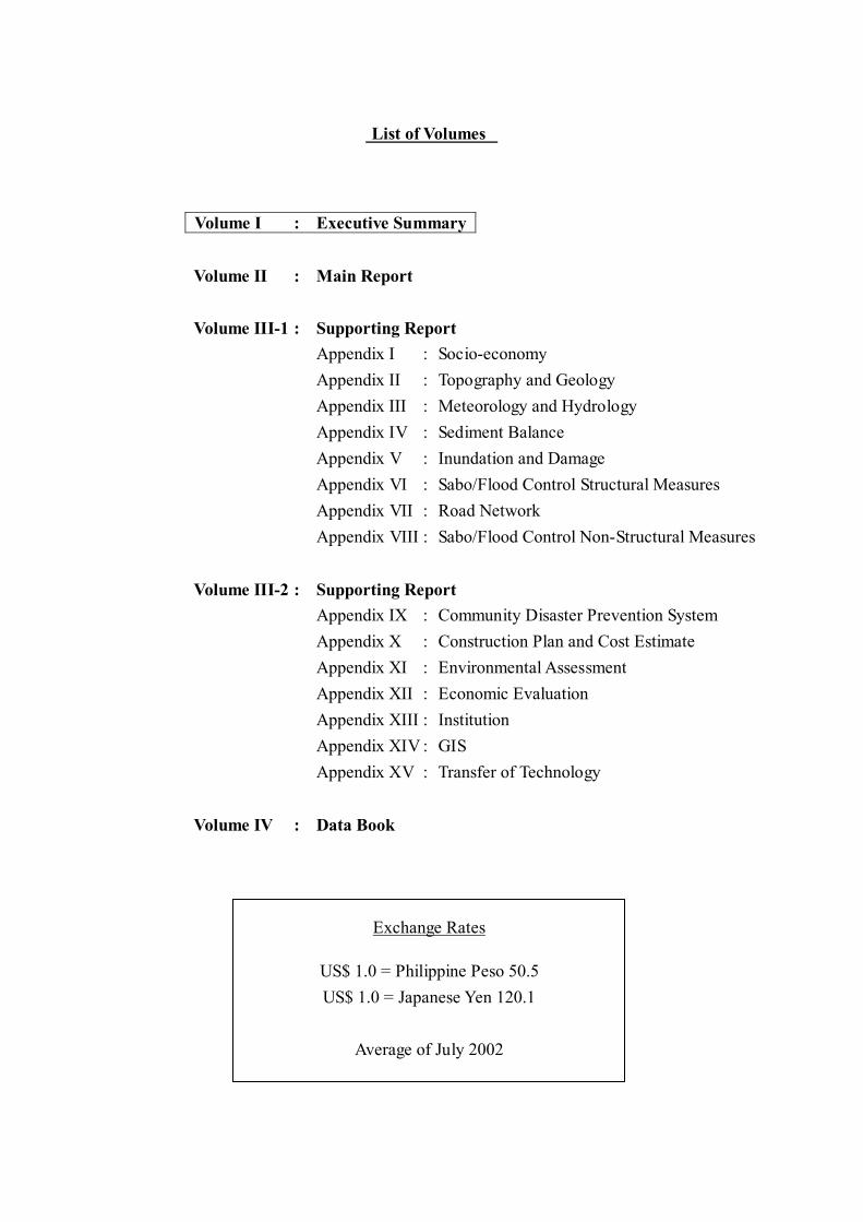
List of Volumes
Volume I : Executive Summary Volume II : Main Report Volume III-1 : Supporting Report
Appendix I : Socio-economy Appendix II : Topography and Geology Appendix III : Meteorology and Hydrology Appendix IV : Sediment Balance Appendix V : Inundation and Damage Appendix VI : Sabo/Flood Control Structural Measures Appendix VII : Road Network Appendix VIII : Sabo/Flood Control Non-Structural Measures
Volume III-2 : Supporting Report
Appendix IX : Community Disaster Prevention System Appendix X : Construction Plan and Cost Estimate Appendix XI : Environmental Assessment Appendix XII : Economic Evaluation Appendix XIII : Institution Appendix XIV : GIS Appendix XV : Transfer of Technology
Volume IV : Data Book
Exchange Rates
US$ 1.0 = Philippine Peso 50.5 US$ 1.0 = Japanese Yen 120.1
Average of July 2002
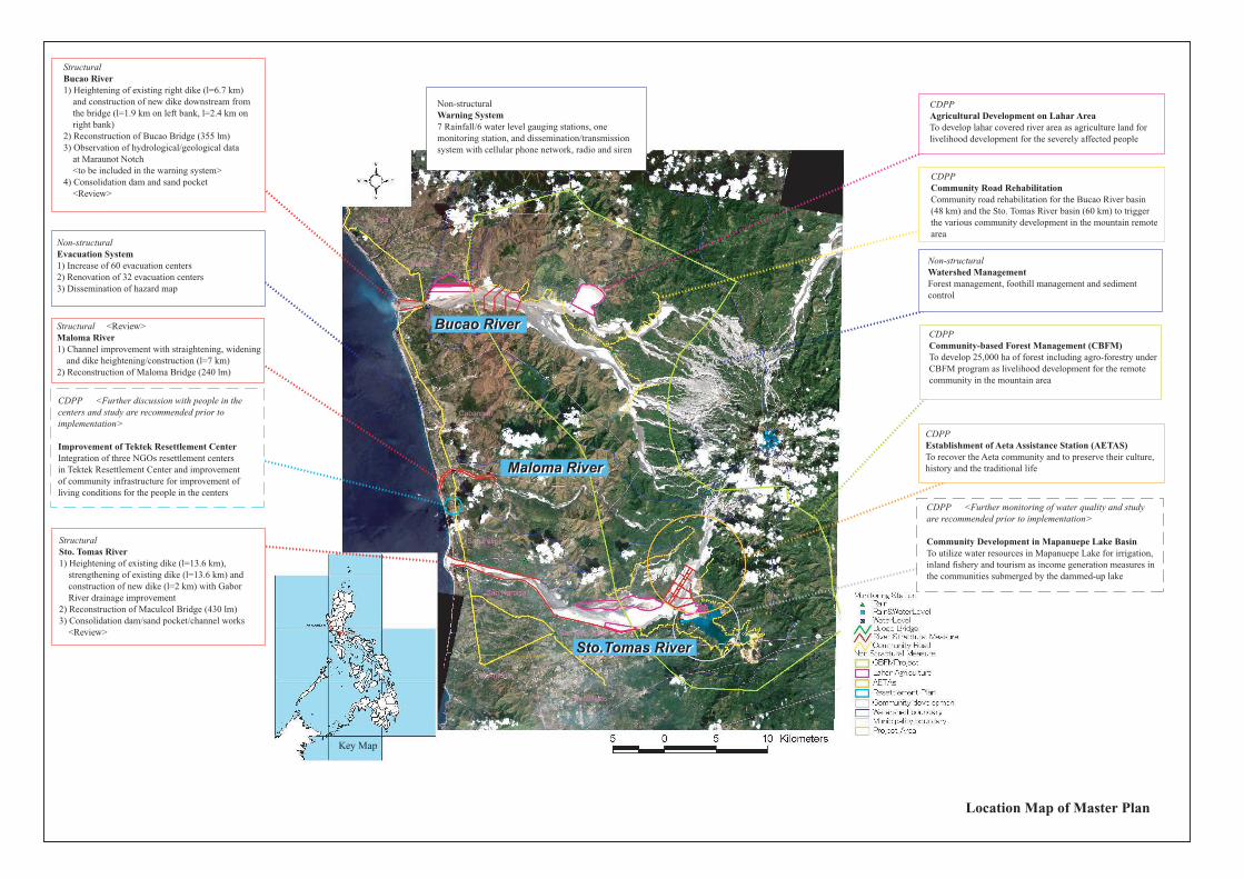
StructuralSto. Tomas River1) Heightening of existing dike (l=13.6 km), strengthening of existing dike (l=13.6 km) and construction of new dike (l=2 km) with Gabor River drainage improvement2) Reconstruction of Maculcol Bridge (430 lm)3) Consolidation dam/sand pocket/channel works <Review>
Key Map
Structural <Review>Maloma River1) Channel improvement with straightening, widening and dike heightening/construction (l=7 km)2) Reconstruction of Maloma Bridge (240 lm)
StructuralBucao River1) Heightening of existing right dike (l=6.7 km) and construction of new dike downstream from the bridge (l=1.9 km on left bank, l=2.4 km on right bank)2) Reconstruction of Bucao Bridge (355 lm)3) Observation of hydrological/geological data at Maraunot Notch <to be included in the warning system>4) Consolidation dam and sand pocket <Review>
CDPP <Further discussion with people in thecenters and study are recommended prior toimplementation>
Improvement of Tektek Resettlement CenterIntegration of three NGOs resettlement centers in Tektek Resettlement Center and improvementof community infrastructure for improvement ofliving conditions for the people in the centers
CDPPCommunity Road RehabilitationCommunity road rehabilitation for the Bucao River basin(48 km) and the Sto. Tomas River basin (60 km) to triggerthe various community development in the mountain remotearea
CDPPAgricultural Development on Lahar AreaTo develop lahar covered river area as agriculture land for livelihood development for the severely affected people
Non-structuralWatershed ManagementForest management, foothill management and sediment control
CDPPEstablishment of Aeta Assistance Station (AETAS)To recover the Aeta community and to preserve their culture,history and the traditional life
CDPP <Further monitoring of water quality and study are recommended prior to implementation>
Community Development in Mapanuepe Lake BasinTo utilize water resources in Mapanuepe Lake for irrigation,inland fishery and tourism as income generation measures inthe communities submerged by the dammed-up lake
CDPPCommunity-based Forest Management (CBFM)To develop 25,000 ha of forest including agro-forestry underCBFM program as livelihood development for the remotecommunity in the mountain area
Non-structuralWarning System7 Rainfall/6 water level gauging stations, one monitoring station, and dissemination/transmission system with cellular phone network, radio and siren
Non-structuralEvacuation System1) Increase of 60 evacuation centers2) Renovation of 32 evacuation centers3) Dissemination of hazard map
Location Map of Master Plan
Iba
Botolan
Cabangan
San Felipe
San Narciso
San Antonio
San Marcelino
Castillejos
Bucao RiverBucao River
Maloma RiverMaloma River
Sto.Tomas RiverSto.Tomas River
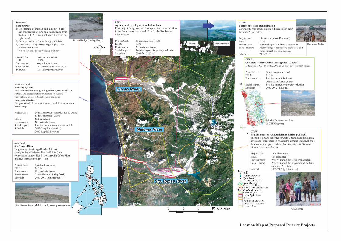
Location Map of Proposed Priority Projects
StructuralBucao River1) Heightening of existing right dike (l=7.5 km) and construction of new dike downstream from the bridge (l=2.1 km on left bank, l=2.4 km on right bank)2) Reconstruction of Bucao Bridge (321 lm)3) Observation of hydrological/geological data at Maraunot Notch <to be included in the warning system>
Project Cost: 1,678 million pesosEIRR: 15.7%Environment: No particular issuesResettlement: 29 families (as of May 2003)Schedule: 2007-2010 (construction)
Sto. Tomas River (Middle reach, looking downstream)
Future imagePresent
Aeta people
Baquilan Bridge
StructuralSto. Tomas RiverHeightening of existing dike (l=13.4 km),strengthening of existing dike (l=13.9 km) andconstruction of new dike (l=2.0 km) with Gabor Riverdrainage improvement (l=1.7 km)
Project Cost: 1,960 million pesosEIRR: 26.3%Environment: No particular issuesResettlement: 77 families (as of May 2003)Schedule: 2007-2010 (construction)
CDPPCommunity Road RehabilitationCommunity road rehabilitation in Bucao River basinfor route-A1 of 16 km
Project Cost: 189 million pesos (Route-A1)EIRR: 2.1%Environment: Positive impact for forest managementSocial Impact: Positive impact for poverty reduction, and enhancement of social servicesSchedule: 2005-2007
CDPPAgricultural Development on Lahar AreaPilot project for agricultural development on lahar for 10 ha in the Bucao downstream and 10 ha for the Sto. Tomas middle reach.
Project Cost: 19 million pesos (pilot)EIRR: 9.8%Environment: No particular issuesSocial Impact: Positive impact for poverty reductionSchedule: 2008-2010 (20 ha)
Present
CDPPEstablishment of Aeta Assistance Station (AETAS)Support to NGOs' activities for Aeta Upland Farming school, assistance for registration of ancestral domain land, livelihooddevelopment program and detailed study for establishmentof Aeta Assistance Station.
Project Cost: 15 million pesosEIRR: Not calculatedEnvironment: Positive impact for forest managementSocial Impact: Positive impact for prevention of tradition, culture of Aeta tribeSchedule: 2005-2009 (pilot scheme)
CDPPCommunity-based Forest Management (CBFM)Extension of CBFM with 2,200 ha as pilot development scheme
Project Cost: 76 million pesos (pilot)EIRR: 21.5%Environment: Positive impact for forest conservation/managementSocial Impact: Positive impact for poverty reductionSchedule: 2007-2012 (2,200 ha)
Bucao Bridge (during Flood)
Non-structuralWarning System7 Rainfall/6 water level gauging stations, one monitoringstation, and dissemination/transmission systemwith cellular phone network, radio and sirenEvacuation SystemDesignation of 10 evacuation centers and dissemination of hazard map
Project Cost: 30 million pesos (operation for 10 years) 82 million pesos (GSM)EIRR: Not calculatedEnvironment: No particular issuesSocial Impact: Positive impact to secure human lifeSchedule: 2003-08 (pilot operation) 2007-12 (GSM system)
Priority Development Area of CBFM (green)
Bucao RiverBucao River
Maloma RiverMaloma River
Sto.Tomas RiverSto.Tomas River
Iba
Botolan
Cabangan
San Felipe
San Narciso
San Antonio
San Marcelino
Castillejos
1
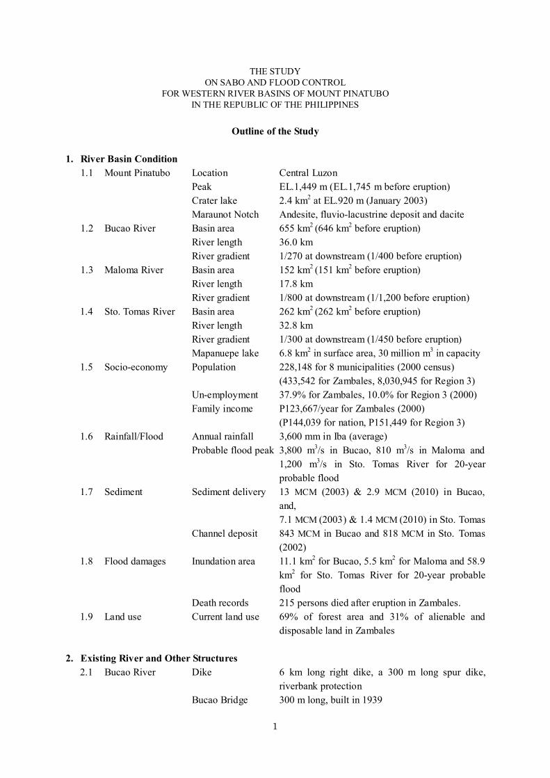
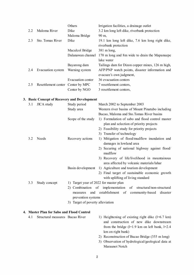
THE STUDY ON SABO AND FLOOD CONTROL
FOR WESTERN RIVER BASINS OF MOUNT PINATUBO IN THE REPUBLIC OF THE PHILIPPINES
Outline of the Study
1. River Basin Condition
1.1 Mount Pinatubo Location Central Luzon Peak EL.1,449 m (EL.1,745 m before eruption) Crater lake 2.4 km2 at EL.920 m (January 2003)
Maraunot Notch Andesite, fluvio-lacustrine deposit and dacite 1.2 Bucao River Basin area 655 km2 (646 km2 before eruption)
River length 36.0 km River gradient 1/270 at downstream (1/400 before eruption)
1.3 Maloma River Basin area 152 km2 (151 km2 before eruption) River length 17.8 km River gradient 1/800 at downstream (1/1,200 before eruption)
1.4 Sto. Tomas River Basin area 262 km2 (262 km2 before eruption) River length 32.8 km River gradient 1/300 at downstream (1/450 before eruption) Mapanuepe lake 6.8 km2 in surface area, 30 million m3 in capacity 1.5 Socio-economy Population 228,148 for 8 municipalities (2000 census) (433,542 for Zambales, 8,030,945 for Region 3) Un-employment 37.9% for Zambales, 10.0% for Region 3 (2000) Family income P123,667/year for Zambales (2000) (P144,039 for nation, P151,449 for Region 3) 1.6 Rainfall/Flood Annual rainfall 3,600 mm in Iba (average) Probable flood peak 3,800 m3/s in Bucao, 810 m3/s in Maloma and
1,200 m3/s in Sto. Tomas River for 20-year probable flood
7.1 MCM (2003) & 1.4 MCM (2010) in Sto. Tomas Channel deposit 843 MCM in Bucao and 818 MCM in Sto. Tomas
(2002) 1.8 Flood damages Inundation area 11.1 km2 for Bucao, 5.5 km2 for Maloma and 58.9
km2 for Sto. Tomas River for 20-year probable flood
Death records 215 persons died after eruption in Zambales. 1.9 Land use Current land use 69% of forest area and 31% of alienable and
disposable land in Zambales
2. Existing River and Other Structures 2.1 Bucao River Dike 6 km long right dike, a 300 m long spur dike,
riverbank protection Bucao Bridge 300 m long, built in 1939
2
Others Irrigation facilities, a drainage outlet 2.2 Maloma River Dike 3.2 km long left dike, riverbank protection Maloma Bridge 90 m, 2.3 Sto. Tomas River Dike 19.1 km long left dike, 7.6 km long right dike,
riverbank protection Maculcol Bridge 381 m long, Dalanawan channel 170 m long and 8m wide to drain the Mapanuepe
lake water Bayarong dam Tailings dam for Dizon copper mines, 126 m high, 2.4 Evacuation system Warning system AFP/PNP watch points, disaster information and
evacuee’s own judgment, Evacuation center 36 evacuation centers 2.5 Resettlement center Center by MPC 7 resettlement centers, Center by NGO 3 resettlement centers,
3. Basic Concept of Recovery and Development
3.1 JICA study Study period March 2002 to September 2003 Study area Western river basins of Mount Pinatubo including
Bucao, Maloma and Sto.Tomas River basins Scope of the study 1) Formulation of sabo and flood control master
plan and selection of priority projects 2) Feasibility study for priority projects
3) Transfer of technology 3.2 Needs Recovery actions 1) Mitigation of flood/mudflow inundation and
damages in lowland area 2) Securing of national highway against flood/
mudflow 3) Recovery of life/livelihood in mountainous
area affected by volcanic materials/lahar Basin development 1) Agriculture and tourism development 2) Final target of sustainable economic growth
with uplifting of living standard 3.3 Study concept 1) Target year of 2022 for master plan 2) Combination of implementation of structural/non-structural
measures and establishment of community-based disaster prevention systems
3) Target of poverty alleviation
4. Master Plan for Sabo and Flood Control 4.1 Structural measures Bucao River 1) Heightening of existing right dike (l=6.7 km)
and construction of new dike downstream from the bridge (l=1.9 km on left bank, l=2.4 km on right bank)
2) Reconstruction of Bucao Bridge (355 m long) 3) Observation of hydrological/geological data at
Maraunot Notch
3
4) Consolidation dam and sand pocket <Review> Maloma River 1) Channel improvement with straightening, <Review> widening and dike heightening/construction
(l=7 km) 2) Reconstruction of Maloma Bridge (240 m
long) Sto.Tomas River 1) Heightening of existing dike (l=13.6 km),
strengthening of existing dike (l=13.6 km) and construction of new dike (l=2 km) with Gabor River drainage improvement
2) Reconstruction of Maculcol Bridge (430 m long)
3) Consolidation dam/sand pocket/channel works <Review>
4.2 Non-structural Warning system 7 Rainfall/6 water level gauging stations, one measures monitoring station, and dissemination/
transmission system with cellular phone network, radio and siren
Evacuation system 1) Increase of 60 evacuation centers 2) Renovation of 32 evacuation centers 3) Dissemination of hazard map Watershed Forest management, foothill management, and management sediment control 4.3 Community-based Improvement of Integration of three NGOs’ resettlement centers in disaster prevention Tektek RC Tektek RC and improvement of community infra. systems <Further discussion and study> CBFM Extension of CBFM for creation of livelihood. Agricultural Agricultural development on lahar at the river side development area for livelihood development. Basin development Community development of Mapanuepe Lake of Mapanuepe Lake basin for irrigation, inland fishery and tourism <Further monitoring and study> Community road Community road rehabilitation in Bucao and
Sto.Tomas River basins AETAS Establishment of Aeta Assistance Station
5. Priority Projects (Feasibility Projects) 5.1 Structural measures Bucao River 1) Heightening of existing right dike (l=7.5 km)
and construction of new dike downstream from the bridge (l=2.1 km on left bank, l=2.4 km on right bank)
2) Reconstruction of Bucao Bridge (321 m long) 3) Observation of hydrological/geological data at
Maraunot Notch Sto.Tomas River 1) Heightening of existing dike (l=13.4 km),
strengthening of existing dike (l=13.9 km) and
4
construction of new dike (l=2.0 km) with Gabor River drainage improvement (l=1.7 km)
5.2 Non-structural Warning system 7 Rainfall/6 water level gauging stations, one measures monitoring station, and dissemination/
transmission system with cellular phone network, radio and siren
Evacuation system Designation of ten evacuation centers, Dissemination of hazard map.
5.3 Community-based CBFM Extension of CBFM with 2,200 ha as pilot disaster prevention development scheme. systems Agricultural Pilot project for agricultural development on lahar development for 10 ha at the Bucao downstream and 10 ha for
the Sto.Tomas middle reach. Community road Community road rehabilitation in Bucao River rehabilitation basin for route-A1 of 16 km. AETAS Supporting NGOs’ activities for Aeta Upland
Farming school, assisting for registration of ancestral domain land, livelihood development program and the detailed study for establishment of Aeta Assistance Station,
5.4 Implementation Organization 1) MPE-PMO, DPWH functioning as implementation agency for the structural measures,
2) PMO-Zambales under Zambales Province functioning as implementation agency for the non-structural and CDPP measures
3) Establishing Project Coordination Committee (PCC) to be functioning for integration among structural, non-structural and CDPP measures.
Funding source GOP and foreign assistance 5.5 Project Evaluation Bucao River 1) Project Cost: 1,678 million pesos Structural 2) EIRR: 15.7% Measures 3) Environment: No particular issues 4) Resettlement: Plan formulated (29 families, as of May 2003) 5) Evaluation: To be implemented 6) Schedule: 2007-2010 (construction) Sto.Tomas River 1) Project Cost: 1,960 million pesos Structural 2) EIRR: 26.3% Measures 3) Environment: No particular issues 4) Resettlement: Plan formulated (77 families, as of May 2003) 5) Evaluation: To be implemented 6) Schedule: 2007-2010 (construction) Non-structural 1) Project Cost: 30 million pesos
Measures (operation for 10 years)
5
82 million pesos (GSM) Warning and 2) EIRR: Not calculated evacuation system 3) Environment: No particular issues 4) Social Impact: Positive impact to secure human life 5) Evaluation: To implement improving the existing system 6) Schedule: 2003-08 (pilot operation) 2007-12 (GSM system) CDPP-CBFM 1) Project Cost: 76 million pesos (Pilot) 2) EIRR: 21.5% 3) Environment: Positive impact for forest conservation/management 4) Social Impact: Positive impact for poverty reduction 5) Evaluation: To implement (Pilot) 6) Schedule: 2007-2012 (2,200 ha) CDPP- 1) Project Cost: 19 million pesos (Pilot) Agricultural 2) EIRR: 9.8% development on 3) Environment: No particular issues lahar area 4) Social Impact: Positive impact for poverty reduction 5) Evaluation To implement (pilot) 6) Schedule: 2008-2010 (20 ha) CDPP- 1) Project Cost: 189 million pesos Community road 2) EIRR: 2.1% rehabilitation 3) Environment: Positive impact for forest management 4) Social Impact: Positive impact for poverty reduction and social services 5) Evaluation: To implement (Route-A1) 6) Schedule: 2005-2007 CDPP-AETAS 1) Project Cost: 15 million pesos 2) EIRR: Not calculated 3) Environment: Positive impact for forest management 4) Social Impact Positive impact for preservation of tradition, culture of Aeta tribe 5) Evaluation: To assist NGOs’ activities 6) Schedule: 2005-2009 (pilot scheme)
i
THE STUDY ON SABO AND FLOOD CONTROL FOR WESTERN RIVER BASINS OF MOUNT PINATUBO
IN THE REPUBLIC OF THE PHILIPPINES
FINAL REPORT
Executive Summary
Table of Contents
List of Volumes Location Map of Master Plan Location Map of Proposed Priority Projects Outline of the Study Abbreviations Measurements
Page
1. INTRODUCTION ..............................................................................................S-1 2. CHANGES IN NATURAL AND SOCIAL CONDITIONS AFTER THE
ERUPTION.........................................................................................................S-2 3. BASIC CONCEPT OF MASTER PLAN...........................................................S-6 4. HYDROLOGY/SEDIMENT YIELD/RIVERBED MOVEMENT
ANALYSIS.........................................................................................................S-8 5. FLOOD/MUDFLOW INUNDATION ANALYSIS .........................................S-13 6. MASTER PLAN FOR STRUCTURAL MEASURES.....................................S-18
6.1 Structural Master Plan for the Bucao River Basin..............................S-18 6.2 Structural Master Plan for the Maloma River Basin...........................S-22 6.3 Structural Master Plan for the Sto. Tomas River Basin ......................S-23
7. MASTER PLAN FOR NON-STRUCTURAL MEASURES...........................S-27 8. MASTER PLAN FOR COMMUNITY DISASTER PREVENTION
PROGRAM.......................................................................................................S-29 9. ECONOMIC EVALUATION, SELECTION OF PRIORITY
PROJECTS AND IMPLEMENTATION SCHEDULE OF MASTER PLAN................................................................................................................S-31
ii
10. FEASIBILITY DESIGN FOR THE PRIORITY PROJECTS..........................S-34
10.1 Dike Heightening and Strengthening in the Lower Bucao River .......S-34 10.2 Dike Heightening and Strengthening for the Sto. Tomas River .........S-38 10.3 Warning and Evacuation System ........................................................S-44 10.4 Community Infrastructure Development at Tektek Resettlement
Center..................................................................................................S-46 10.5 Extension of Community-Based Forest Management Program .........S-47 10.6 Agricultural Development on Lahar Area ..........................................S-49 10.7 Community Development in the Mapanuepe Lake Basin..................S-53 10.8 Community Road Development in Mountainous Area.......................S-55 10.9 Establishment of Aeta Assistance Station (AETAS)...........................S-57
11. PROJECT IMPLEMENTATION PLAN ..........................................................S-59 12. PROJECT EVALUATION................................................................................S-62 13. CONCLUSION AND RECOMMENDATIONS..............................................S-64
List of Tables
Page
Table 2.1 Damages from the Eruption of Mount Pinatubo (1991) ............................S-2 Table 2.2 Population Change in the Philippines, Region 3, Zambales
Province and Study Area............................................................................S-2 Table 4.1 Probable Peak Discharge at Downstream End of the Three Rivers...........S-9 Table 4.2 Comparison of Specific Discharge and Creager’s C-Value in Eight
River Basins around Mount Pinatubo ........................................................S-9 Table 4.3 Estimated Sediment Yield in 2001 ...........................................................S-10 Table 4.4 Estimated Sediment Yield in 2002 ...........................................................S-10 Table 4.5 Summary of Mudflow and Riverbed Movement Analysis ......................S-11 Table 5.1 Summary of Floods in July 2002 .............................................................S-13 Table 5.2 Bank-full Capacity for the Bucao River...................................................S-15 Table 5.3 Bank-full Capacity for the Maloma River ...............................................S-15 Table 5.4 Bank-full Capacity for the Sto. Tomas River ...........................................S-15 Table 5.5 Summary of Inundation Simulation .........................................................S-16 Table 6.1 Purpose of Structures for Sabo and Flood Control ..................................S-18 Table 6.2 List of Identified Sabo Dams ...................................................................S-19 Table 7.1 Roles of Overall Non-structural Measures...............................................S-27
iii
Table 8.1 CDPP Overall Plan...................................................................................S-30 Table 9.1 Results of Economic Evaluation and Selection of Priority Projects........S-31 Table 9.2 Implementation Schedule for Master Plan...............................................S-33 Table 10.1 Principal Features on Bucao Dike Design ...............................................S-35 Table 10.2 Principal Feature of the Bucao Bridge .....................................................S-36 Table 10.3 Project Cost on Priority Project for the Bucao River...............................S-37 Table 10.4 Conditions for Economic Evaluation .......................................................S-37 Table 10.5 Result of Economic Evaluation for the Bucao River...............................S-37 Table 10.6 Project Cost for the Sto. Tomas Priority Works .......................................S-41 Table 10.7 Results of Economic Evaluation for the Sto. Tomas River......................S-41 Table 10.8 Results of Flood Inundation Analysis for Stage-wise Development .......S-41 Table 10.9 Results of Economic Evaluation for Stage-wise Development ...............S-42 Table 10.10 CBFM Development Cost for Priority Development Area......................S-48 Table 10.11 Soil Investigation for Lahar .....................................................................S-49 Table 10.12 Appropriate Crops on Lahar Area............................................................S-50 Table 10.13 Economic Evaluation of Agricultural Development Plan on Lahar.........S-51 Table 10.14 Design Criteria of Community Road .......................................................S-55 Table 11.1 Priority Projects and Responsible Agencies.............................................S-59 Table 12.1 Required Mode of Resettlement and Compensation................................S-62 Table 12.2 Results of Economic Evaluation for Priority Projects .............................S-63 Table 13.1 Results of the Project Evaluation and Recommendations........................S-64
List of Figures
Page
Figure 1.1 Eight Rivers around Mount Pinatubo.........................................................S-1 Figure 2.1 Damage in Zambales Province and Region 3 ............................................S-2 Figure 2.2 Change in Harvested Area of Paddy per Farmer........................................S-3 Figure 2.3 Change in Production Yield of Paddy ........................................................S-3 Figure 2.4 Change in Family Income in Study Area ...................................................S-3 Figure 2.5 Land Use Change in Western River Basins of Mount Pinatubo ................S-4 Figure 2.6 Existing Condition in the Sto. Tomas River Basin.....................................S-5 Figure 2.7 Existing Condition in the Bucao River Basin ............................................S-5 Figure 3.1 Basic Concept of Master Plan....................................................................S-7 Figure 4.1 Isohyetal Map around Mount Pinatubo (1995)..........................................S-8 Figure 4.2 Comparison of Accumulated Rainfall between Eastern and
Western Areas of Mount Pinatubo during Flood in July 2002 ...................S-8 Figure 4.3 Specific Discharges in Pinatubo Basins .....................................................S-9
iv
Figure 4.4 Estimated Future Sediment Yield in the Bucao and Sto. Tomas River Basins .............................................................................................S-10
Figure 4.5 Mechanism of Sediment Transport Clarified by Sediment Balance Analysis....................................................................................................S-11
Figure 4.6 Results of 2-D Mudflow and 1-D Riverbed Movement Analysis in the Bucao River........................................................................................S-12
Figure 4.7 Results of 2-D Mudflow and 1-D Riverbed Movement Analysis in the Sto. Tomas River ................................................................................S-12
Figure 5.1 General Definition of Safety Discharge and Bank-full Capacity.............S-14 Figure 5.2 Change in Bank-full Capacity..................................................................S-14 Figure 5.3 Inundation Blocks and Breach Points of Dike for the Bucao,
Maloma and Sto. Tomas Rivers ...............................................................S-15 Figure 5.4 Damage Curve for Building.....................................................................S-16 Figure 5.5 Damage Curve for Farmland....................................................................S-16 Figure 5.6 Mudflow Hazard Area in the Bucao River Basin under 100-year
Probable Flood .........................................................................................S-17 Figure 5.7 Mudflow Hazard Area in the Maloma River Basin under 100-year
Probable Flood .........................................................................................S-17 Figure 5.8 Mudflow Hazard Area in the Sto. Tomas River Basin under
100-year Probable Flood ..........................................................................S-17 Figure 6.1 Conceivable Plan including Master Plan on the Structural
Measures of the Bucao River Basin.........................................................S-18 Figure 6.2 Location of Identified Sabo Dam Sites in the Bucao River Basin...........S-19 Figure 6.3 Alternative Structural Measures for the Bucao River..............................S-20 Figure 6.4 Results of Two-Dimensional Mudflow Analysis .....................................S-20 Figure 6.5 Damage Record of the Bucao Bridge after 1991 .....................................S-21 Figure 6.6 Structural Master Plan for the Maloma River Basin ................................S-22 Figure 6.7 Conceivable Plan including Master Plan for the Sto. Tomas River
Basin.........................................................................................................S-23 Figure 6.8 Alternative Measures in the Sto. Tomas River Baisn...............................S-24 Figure 6.9 Results on Two-Dimensional Short Term Mudflow Analysis..................S-24 Figure 6.10 Results on One-Dimensional Long Term Riverbed Movement
Analysis....................................................................................................S-24 Figure 6.11 Observed Flood Regulation Effect by Mapanuepe Lake during the
Flood of July 2002 ...................................................................................S-25 Figure 7.1 Proposed Monitoring and Warning System .............................................S-27 Figure 7.2 Five Categories under Watershed Management.......................................S-28 Figure 8.1 Master Plan for the CDPP........................................................................S-30 Figure 10.1 General View of the Priority Project for the Bucao River .......................S-34 Figure 10.2 Flowchart of Design of Dike Profile ........................................................S-35 Figure 10.3 Design Dike Profile ..................................................................................S-35
v
Figure 10.4 Typical Cross Section of the Bucao River Dike Strengthening Work.........................................................................................................S-35
Figure 10.5 Typical Section of the Bucao Bridge .......................................................S-36 Figure 10.6 Dike Strengthening at Middle Reach of the Sto. Tomas River ................S-38 Figure 10.7 Design Dike Profile in the Sto. Tomas River ...........................................S-38 Figure 10.8 General Plan for the Downstream Reach of the Sto. Tomas River ..........S-39 Figure 10.9 Riverbed and Land Profile at the Middle Reach of the Sto. Tomas
River.........................................................................................................S-40 Figure 10.10 Gully Erosion at Sta. 17 km .....................................................................S-40 Figure 10.11 Gully Erosion at Sta. 17.5 km ..................................................................S-40 Figure 10.12 Typical Section of Dike Strengthening at Middle Reach of the Sto.
Tomas River .............................................................................................S-40 Figure 10.13 Damage Curve for Inundated Houses ......................................................S-42 Figure 10.14 Damage Curve for Inundated Farm Land ................................................S-42 Figure 10.15 Mudflow Inundation Area of Middle Reach of the Sto. Tomas
River, Left Bank.......................................................................................S-43 Figure 10.16 Proposed Warning System .......................................................................S-44 Figure 10.17 Coverage Area of Existing Cellular Phone Network ...............................S-44 Figure 10.18 Example of Hazard Map for San Felipe (Right Bank of the
Sto.Tomas River)......................................................................................S-45 Figure 10.19 Priority Development Area of CBFM (Green).........................................S-47 Figure 10.20 Effect of CBFM on Poverty Alleviation ..................................................S-48 Figure 10.21 Development Image for Lahar Agriculture (Sto. Tomas Middle
Reach) ......................................................................................................S-49 Figure 10.22 Agricultural Development Potential Area................................................S-50 Figure 10.23 General Plan for the Bucao Lahar Agriculture Development ..................S-52 Figure 10.24 General Plan for the Sto. Tomas Lahar Agriculture Development...........S-52 Figure 10.25 Community Development in the Mapanuepe Lake Basin .......................S-53 Figure 10.26 Collapse of Spillway of Dizon Dam ........................................................S-53 Figure 10.27 Community Road Development...............................................................S-55 Figure 10.28 Effect of Community Road Development on Poverty Alleviation ..........S-56 Figure 10.29 Aeta Community and Activities of NGOs ...............................................S-58 Figure 11.1 Proposed Institutional Chart for the Project.............................................S-60 Figure 11.2 Project Implementation Schedule for Priority Projects............................S-61
vi
Abbreviations
A AETAS - Aeta Assistance Station AFP - Armed Forces of the Philippines B BOD - Biochemical Oxygen Demand C CBFM - Community-Based Forest Management CDPP - Community-Based Disaster Prevention Plan COD - Chemical Oxygen Demand D DA - Department of Agriculture
DENR - Department of Environment and Natural Resources DILG - Department of Interior and Local Government DPWH - Department of Public Works and Highways DSWD - Department of Social Welfare and Development E ECC - Environmental Compliance Certificate
EIA - Environmental Impact Assessment EIRR - Economic Internal Rate of Return EIS - Environmental Impact Statement
F FMB - Forest Management Bureau, DENR G GIS - Geographic Information System GDP - Gross Domestic Product GOJ - Government of Japan GOP - Government of the Philippines GRDP - Gross Regional Domestic Product GSM - Global System for Mobile Communications H HH - Household I ICC - Investment Coordination Committee, NEDA
IEE - Initial Environmental Examination J JBIC - Japan Bank for International Cooperation JICA - Japan International Cooperation Agency K K - Potassium L LGU - Local Government Unit M MPC - Mount Pinatubo Commission MPE - Mount Pinatubo Emergency, DPWH MPR - Mount Pinatubo Rehabilitation, DPWH N N - Nitrogen NCIP - National Commission on Indigenous People
vii
NCR - National Capital Region NDCC - National Disaster Coordinating Council NEDA - National Economic and Development Authority NGO - Non-Government Organization NSCB - National Statistical Coordination Board
NSO - National Statistics Office NWRB - National Water Resources Board O OCD - Office of Civil Defense P P - Phosphorus PAGASA - Philippine Atmospheric, Geophysical and Astronomical
Services Administration PCC - Project Coordination Committee PCM - Project Cycle Management PDCC - Provincial Disaster Coordinating Council PHIVOLCS - Philippine Institute of Volcanology and Seismology PMO - Project Management Office PNP - Philippine National Police R RC - Resettlement Center RDC - Regional Development Council RDCC - Regional Disaster Coordinating Council S SALT - Slope Agriculture Land Technology U USACE - United States Army Corps of Engineers
viii
Measurements
Length Area mm = millimeter m2 = square meter cm = centimeter ha = hectare m = meter km2 = square kilometer km = kilometer LM = linear meter Volume Derived Measures cm3 = cubic centimeter m/s = meter per second l = liter m3/s = cubic meter per second kl = kiloliter kWh = kilowatt hour m3 = cubic meter MWh = megawatt hour MCM = million cubic meter GWh = gigawatt hour ppm = parts per million kmph = kilometer per hour lps/m = liter per second per meter Weight Currency g = gram PHP = Philippine Peso kg = kilogram ¥ = Japanese Yen ton = metric ton US$ = US Dollar meq = milligram equivalent Time Other Measure sec = second % = percent min = minute o = degree hr = hour oC = degree(s) Celsius d = day 103 = thousand y = year 106 = million 109 = billion pH = potential of hydrogen mbgs = meter below ground surface M = magnitude of earthquake