Creating Hybrid Advancement Universal Scan-to-GIS desktop Transfer Maps, Plans, Image Data to GIS Exact Georeferencing and Calibration Vectorization and Polygon Conversion map Series HYBRID BRIDGE TO GIS & FM
Transcript
Creating Hybrid Advancement
Universal Scan-to-GIS desktop
Transfer Maps, Plans, Image Data to GIS
Exact Georeferencing and Calibration
Vectorization and Polygon Conversion
map SeriesHYBRID BRIDGE TO GIS & FM
map SeriesHYBRID BRIDGE TO GIS & FM
Scanning
Merging Maps
Georeferencing
Managing Colors
Seamless GIS Integration
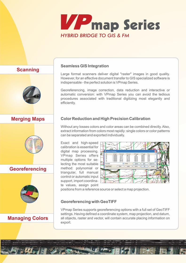
Color Reduction and High Precision Calibration
Georeferencing with GeoTIFF
Large format scanners deliver digital "raster" images in good quality.
However, for an effective document transfer to GIS specialized software is
indispensable - the perfect solution is VPmap Series.
Georeferencing, image correction, data reduction and interactive or
automatic conversion: with VPmap Series you can avoid the tedious
procedures associated with traditional digitizing most elegantly and
efficiently.
Without any losses colors and color areas can be combined directly. Also,
extract information from colors most rapidly: single colors or color patterns
can be separated and exported individually.
Exact and high-speed
calibration is essential for
digital map processing.
VPmap Series offers
multiple options for se-
lecting the most suitable
method: polynomial or
triangular, full manual
control or automatic input
support, import coordina-
te values, assign point
positions from a reference source or select a map projection.
VPmap Series supports georeferencing options with a full set of GeoTIFF
settings. Having defined a coordinate system, map projection, and datum,
all objects, raster and vector, will contain accurate placing information on
export.
Creating Hybrid Advancement
Vectorization
Attributes
Mosaicing
Export to GIS
Paper maps, satellite images, and aerial photography
are a major data source for GIS. Fully equipped, easy to
use, and independent from any target GIS platform,
VPmap Series provides accurate integration,
calibration, and conversion of original maps and plans
with two product alternatives:
Quick Conversion
Mosaicing
GIS and Facility Management Usability
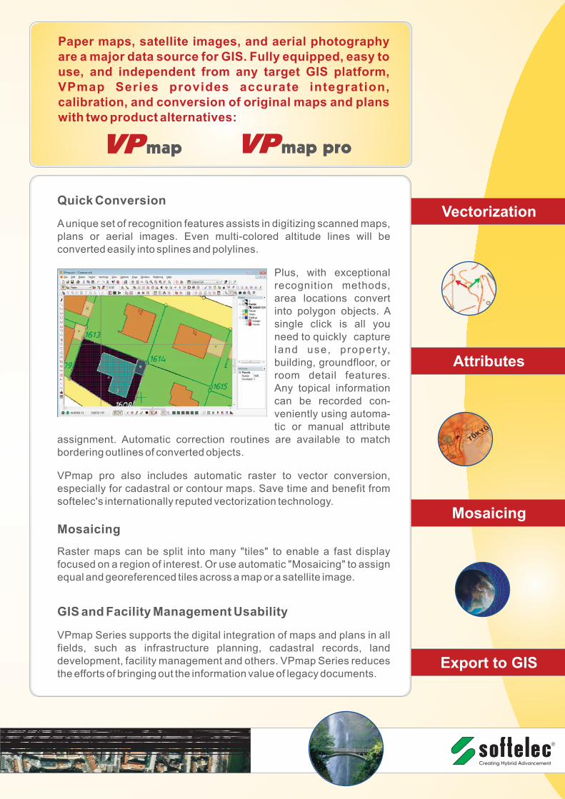
Aunique set of recognition features assists in digitizing scanned maps,
plans or aerial images. Even multi-colored altitude lines will be
converted easily into splines and polylines.
Plus, with exceptional
recognition methods,
area locations convert
into polygon objects. A
single click is all you
need to quickly capture
land use, proper ty,
building, groundfloor, or
room detail features.
Any topical information
can be recorded con-
veniently using automa-
tic or manual attribute
assignment. Automatic correction routines are available to match
bordering outlines of converted objects.
VPmap pro also includes automatic raster to vector conversion,
especially for cadastral or contour maps. Save time and benefit from
Raster maps can be split into many "tiles" to enable a fast display
focused on a region of interest. Or use automatic "Mosaicing" to assign
equal and georeferenced tiles across a map or a satellite image.
VPmap Series supports the digital integration of maps and plans in all
fields, such as infrastructure planning, cadastral records, land
development, facility management and others. VPmap Series reduces
the efforts of bringing out the information value of legacy documents.
map map pro
Creating Hybrid Advancement
softelec GmbH
Munich, Germany
www.softelec.com Creating Hybrid Advancement
Universal Scan-to-GIS desktop
Transfer Maps, Plans, Image Data to GIS
Exact Georeferencing and Calibration
Vectorization and Polygon Conversion
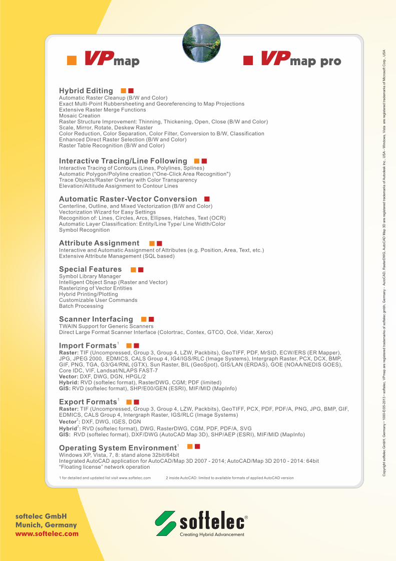
Hybrid Editing
Interactive Tracing/Line Following
Automatic Raster-Vector Conversion
Attribute Assignment
Special Features
Scanner Interfacing
Import Formats
Export Formats
Operating System Environment
Automatic Raster Cleanup (B/W and Color)Exact Multi-Point Rubbersheeting and Georeferencing to Map ProjectionsExtensive Raster Merge FunctionsMosaic CreationRaster Structure Improvement: Thinning, Thickening, Open, Close (B/W and Color)Scale, Mirror, Rotate, Deskew RasterColor Reduction, Color Separation, Color Filter, Conversion to B/W, ClassificationEnhanced Direct Raster Selection (B/W and Color)Raster Table Recognition (B/W and Color)
Interactive Tracing of Contours (Lines, Polylines, Splines)Automatic Polygon/Polyline creation ("One-Click Area Recognition")Trace Objects/Raster Overlay with Color TransparencyElevation/Altitude Assignment to Contour Lines
Centerline, Outline, and Mixed Vectorization (B/W and Color)Vectorization Wizard for Easy SettingsRecognition of: Lines, Circles, Arcs, Ellipses, Hatches, Text (OCR)Automatic Layer Classification: Entity/Line Type/ Line Width/ColorSymbol Recognition
Interactive and Automatic Assignment of Attributes (e.g. Position, Area, Text, etc.)Extensive Attribute Management (SQL based)
Symbol Library ManagerIntelligent Object Snap (Raster and Vector)Rasterizing of Vector EntitiesHybrid Printing/PlottingCustomizable User CommandsBatch Processing
TWAIN Support for Generic ScannersDirect Large Format Scanner Interface (Colortrac, Contex, GTCO, Océ, Vidar, Xerox)
TIF (Uncompressed, Group 3, Group 4, LZW, Packbits), GeoTIFF, PDF, MrSID, ECW/ERS (ER Mapper),JPG, JPEG 2000, EDMICS, CALS Group 4, IG4/IGS/RLC (Image Systems), Intergraph Raster, PCX, DCX, BMP,GIF, PNG, TGA, G3/G4/RNL (GTX), Sun Raster, BIL (GeoSpot), GIS/LAN (ERDAS), GOE (NOAA/NEDIS GOES),Core IDC, VIF, Landsat/NLAPS FAST-7
DXF, DWG, DGN, HPGL/2RVD (softelec format), RasterDWG, CGM; PDF (limited)
1 for detailed and updated list visit www.softelec.com 2 inside AutoCAD: limited to available formats of applied AutoCAD version
Raster:
Vector:Hybrid:GIS:
Raster:
Vector :
Hybrid :GIS:
2
2
Windows XP, Vista, 7, 8: stand alone 32bit/64bitIntegrated AutoCAD application for AutoCAD/Map 3D 2007 - 2014; AutoCAD/Map 3D 2010 - 2014: 64bit“Floating license” network operation