Annual Newsletter 2021 W ILDLAND F IRE S UPPRESSION A SSESSMENT D ISTRICT M ESSAGE FROM THE C HIEF INSIDE THIS ISSUE: Chief's Message…................ 1 Chipping Map….…………. 2 Chipping Instructions…… 3 Defensible Space ………... 4 Be Prepared…………….... 5 Vegetation Management.... 6 CWPP Update …………... 7 Websites….………………. 8 Thank you to all who have welcomed me as Interim Fire Chief with the Santa Barbara City Fire Department. As a born and raised Santa Barbara resident, I feel particularly honored to assume this role for a few months. Fire Chief Eric Nickel retired with over 32 years of service. During his tenure, he set up a wonderful blueprint for us to follow to help keep the community safe. During my time on the south coast, I have personally witnessed the devastation of many wildfires including the Coyote, Sycamore, Paint, Tea, Gap, Jesusita, Sherpa, Whittier and Thomas Fires. Simply, we live in one of the most fire-prone areas in all of the United States. Our unique mountain range and weather makes us especially susceptible to major wildfires. Your City Fire Department appreciates the support you have given us as we continue to do our best to mitigate the threats that our City faces. As was noted in the last newsletter, this in fact may be our “new abnormal.” As of this writing, we appear to be headed into a very dry winter, another La Nina. Your Fire Department is in the final stages of updating your Community Wildfire Protection Plan (CWPP). We very much appreciate the community input and support. We were fortunate to secure a grant from CAL FIRE to complete this much-needed update to our Plan. As the Plan is finalized, you will receive more information on how we will continue to mitigate the ongoing threat of wildfire. We are fortunate to have strong and supportive leadership from City Administrator Paul Casey, Mayor Cathy Murillo, City Council and all City Departments. All of your City employees work collaboratively together to ensure that your safety is our top priority. Additionally, our County operational area fire partners along with State and Federal fire agencies, all play a significant role in keeping this community safe from wild fire. Please continue to reach out to your Fire Department for guidance. We have an amazing team of employees who place your safety as our highest priority. Please make use of our free services to reduce your risk of wild fire. Additionally, continue to care for your property by creating defensible space, planting or replacing foliage with drought-tolerant landscaping and have a plan if wildfire arrives. We thank you for your continued support of the City of Santa Barbara and its Fire Department. -Interim Fire Chief, Chris Mailes Thank you for your support. Since 2006 we’ve: Chipped more than 4500 tons of vegetation through our annual chipping program Cleared 210 miles of roadways through our vegetation road clearance program Treated 180 acres of flammable vegetation through fuels management projects Evaluated over 560 properties to assess potential defensible space improvements T HIS Y EAR IN T HE WFSAD While 2020 presented many challenges, the Wildland Fire Suppression Assessment District (WFSAD) has continued to provide its programs and services that reduce the danger wildfires pose to the City. In this year’s newsletter we provide information on our Annual Chipping Program, Defensible Space, Road Clearance, Vegetation Management, and updates on the development of the Community Wildfire Protection Plan (CWPP). As we continue these programs and services into 2021, we would like to thank all residents of the for your continued efforts to maintain their Defensible Space and improve wildfire safety in our community.
Transcript
Annual Newslet ter 2021
W I L D L A N D F I R E S U P P R E S S I O N A S S E S S M E N T D I S T R I C T
M E S S A G E F R O M T H E C H I E F
I N S I D E T H I S I S S U E :
Chief's Message…................ 1
Chipping Map….…………. 2
Chipping Instructions…… 3
Defensible Space ………... 4
Be Prepared…………….... 5
Vegetation Management.... 6
CWPP Update …………... 7
Websites….………………. 8
Thank you to all who have welcomed me as Interim Fire Chief with the Santa Barbara City Fire Department. As a born and raised Santa Barbara resident, I feel particularly honored to assume this role for a few months. Fire Chief Eric Nickel retired with over 32 years of service. During his tenure, he set up a wonderful blueprint for us to follow to help keep the community safe.
During my time on the south coast, I have personally witnessed the devastation of many wildfires including the Coyote, Sycamore, Paint, Tea, Gap, Jesusita, Sherpa, Whittier and Thomas Fires. Simply, we live in one of the most fire-prone areas in all of the United States. Our unique mountain range and weather makes us especially susceptible to major wildfires. Your City Fire Department appreciates the support you have given us as we continue to do our best to mitigate the threats that our City faces. As was noted in the last newsletter, this in fact may be our “new abnormal.” As of this writing, we appear to be headed into a very dry winter, another La Nina.
Your Fire Department is in the final stages of updating your Community Wildfire Protection Plan (CWPP). We very much appreciate the community input and support. We were fortunate to secure a grant from CAL FIRE to complete this much-needed update to our Plan. As the Plan is finalized, you will receive more information on how we will continue to mitigate the ongoing threat of wildfire.
We are fortunate to have strong and supportive leadership from City Administrator Paul Casey, Mayor Cathy Murillo, City Council and all City Departments. All of your City employees work collaboratively together to ensure that your safety is our top priority. Additionally, our County operational area fire partners along with State and Federal fire agencies, all play a significant role in keeping this community safe from wild fire.
Please continue to reach out to your Fire Department for guidance. We have an amazing team of employees who place your safety as our highest priority. Please make use of our free services to reduce your risk of wild fire. Additionally, continue to care for your property by creating defensible space, planting or replacing foliage with drought-tolerant landscaping and have a plan if wildfire arrives.
We thank you for your continued support of the City of Santa Barbara and its Fire Department.
-Interim Fire Chief, Chris Mailes
Thank you for your support.
Since 2006 we’ve:
Chipped more than
4500 tons of vegetation through
our annual chipping program
Cleared 210 miles of roadways
through our vegetation road
clearance program
Treated 180 acres of flammable
vegetation through fuels
management projects
Evaluated over 560 properties
to assess potential defensible
space improvements
T H I S Y E A R I N T H E W F S A D While 2020 presented many challenges, the Wildland Fire Suppression Assessment District (WFSAD) has continued to provide its programs and services that reduce the danger wildfires pose to the City. In this year’s newsletter we provide information on our Annual Chipping Program, Defensible Space, Road Clearance, Vegetation Management, and updates on the development of the Community Wildfire Protection Plan (CWPP). As we continue these programs and services into 2021, we would like to thank all residents of the for your continued efforts to maintain their Defensible Space and improve wildfire safety in our community.
Page 2 2021
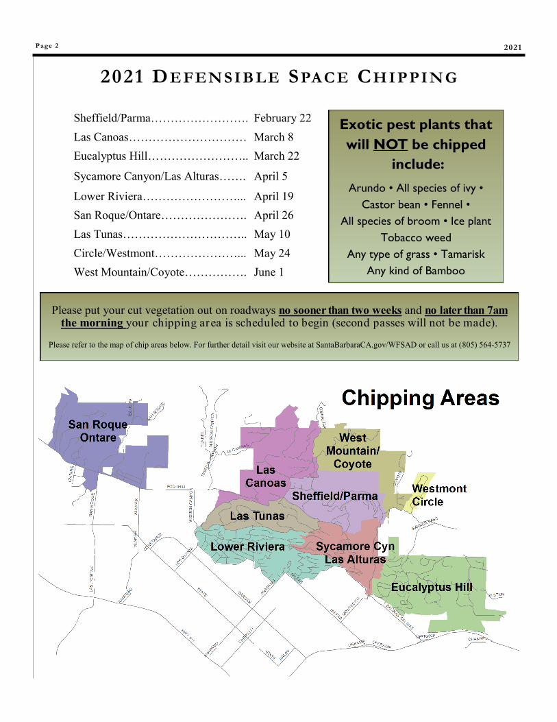
Sheffield/Parma……………………. February 22
Las Canoas………………………… March 8
Eucalyptus Hill…………………….. March 22
Sycamore Canyon/Las Alturas……. April 5
Lower Riviera……………………... April 19
San Roque/Ontare…………………. April 26
Las Tunas………………………….. May 10
Circle/Westmont…………………... May 24
West Mountain/Coyote……………. June 1
Please put your cut vegetation out on roadways no sooner than two weeks and no later than 7am the morning your chipping area is scheduled to begin (second passes will not be made).
Please refer to the map of chip areas below. For further detail visit our website at SantaBarbaraCA.gov/WFSAD or call us at (805) 564-5737
Exotic pest plants that
will NOT be chipped
include:
Arundo • All species of ivy •
Castor bean • Fennel •
All species of broom • Ice plant
Tobacco weed
Any type of grass • Tamarisk
Any kind of Bamboo
2021 DE FEN S IB L E SPAC E CH I PPI N G
Wildland Fire Suppression Assessment Distr ict Page 3
CH I PPI NG IN S TRUCT ION S
Chipping services are provided to encourage property owners to create defensible space and provide a cost effective way to dispose of cut material.
As part of the City’s environmental efforts, our goal is to re-use 100% of all chipped material. To achieve this goal we need your help. If you can use chips on your property please contact us at (805) 564-5737. A load of chips is approximately 14 cubic yards. Partial loads are not available.
The chipping instructions (right) outline the specific requirements. Vegetation that does not meet these requirements will not be chipped and will be left on site. The property owner will be responsible for the legal disposal of any material that cannot be chipped.
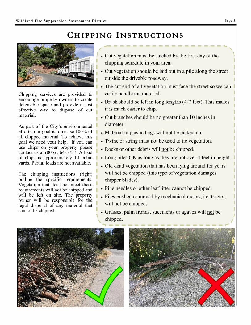
Cut vegetation must be stacked by the first day of the
chipping schedule in your area.
Cut vegetation should be laid out in a pile along the street
outside the drivable roadway.
The cut end of all vegetation must face the street so we can
easily handle the material.
Brush should be left in long lengths (4-7 feet). This makes
it is much easier to chip.
Cut branches should be no greater than 10 inches in
diameter.
Material in plastic bags will not be picked up.
Twine or string must not be used to tie vegetation.
Rocks or other debris will not be chipped.
Long piles OK as long as they are not over 4 feet in height.
Old dead vegetation that has been lying around for years
will not be chipped (this type of vegetation damages
chipper blades).
Pine needles or other leaf litter cannot be chipped.
Piles pushed or moved by mechanical means, i.e. tractor,
will not be chipped.
Grasses, palm fronds, succulents or agaves will not be
chipped.
Page 4
DE FE NS IBL E SPACE EVALUAT ION S
Defensible Space Tips
Reduce Fire Ladders: Separate and space your plants both horizontally and vertically.
Reduce Ignition Sources: Embers may blow miles ahead of the fire. Frequently check and remove leaves and debris from roofs and gutters. Check under decks and porches, deck furniture, play/storage structures, doormats, and potted plants.
Trees: Remove branches from the ground a minimum of 6 feet or 1/3 the total height of the tree. Remove all dead branches.
Brush: Remove dead fuel and limb up 2 feet from the ground. Keep separation between shrubs, brush and trees.
Grass: Mow to 4 inches from the ground.
Debris Piles: Do not pile wood chips or mulch on your property. Spread and maintain them no greater than a 4 to 4 inch depth. Compost should be kept in an appropriate container.
Ornamental Plants: Should be irrigated, maintained and pruned year-round.
W H A T I S I N V O L V E D I N A D E F E N S I B L E S P A C E E V A L U A T I O N ?
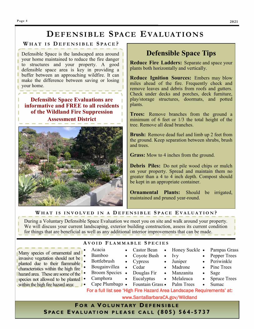
Defensible Space is the landscaped area around your home maintained to reduce the fire danger to structures and your property. A good defensible space area is key in providing a buffer between an approaching wildfire. It can make the difference between saving or losing your home.
F O R A V O L U N TA RY D E F E N S I B L E
S PA C E E VA L U AT I O N P L E A S E C A L L ( 8 0 5 ) 5 6 4 - 5 7 3 7
Defensible Space Evaluations are informative and FREE to all residents
of the Wildland Fire Suppression
Assessment District
W H A T I S D E F E N S I B L E S P A C E ?
During a Voluntary Defensible Space Evaluation we meet you on site and walk around your property. We will discuss your current landscaping, exterior building construction, assess its current condition for things that are beneficial as well as any additional interior improvements that can be made.
A V O I D F L A M M A B L E S P E C I E S
Many species of ornamental and invasive vegetation should not be planted due to their flammable characteristics within the high fire hazard area. These are some of the species not allowed to be planted within the high fire hazard area:
Acacia
Bamboo
Bottlebrush
Bougainvillea
Broom Species
Camphora
Cape Plumbago
Castor Bean
Coyote Bush
Cypress
Cedar
Douglas Fir
Eucalyptus
Fountain Grass
Honey Suckle
Ivy
Juniper
Madrone
Manzanita
Melaleuca
Palm Trees
Pampas Grass
Pepper Trees
Periwinkle
Pine Trees
Sage
Spruce Trees
Sumac
For a full list see ‘High Fire Hazard Area Landscape Requirements’ at:
www.SantaBarbaraCA.gov/Wildland
2021
Page 5
B E P R E PA R E D In addition to preparing your defensible space it is important to utilize services that can provide critical information in the event of a wildfire or other natural disaster. Signing up for READYSBC Alerts will register your phone number and/or email address for alerts during emergencies. A message will be sent regarding potential safety hazard or concerns to the voice, email, or text communication methods that you have registered. Registration only takes a minute and can be found at:
ReadySBC.org
Santa Barbara City’s READY, SET, GO! guide is part of a national campaign that provides a wildland fire action plan for homeowners and information critical in preparing for a wildfire. This guide covers defensible space strategies, fire-wise landscape management tips specific to our local landscape and provides a personal wildfire action plan to prepare before having to evacuate. A copy of the guide can be found on the WFSAD website under the “Helpful Links” tab:
www.SantaBarbaraCA.gov/WFSAD
If you would like a copy of Ready, Set, Go!, please contact Chris Braden, Fire Services Specialist at
(805) 564-5737
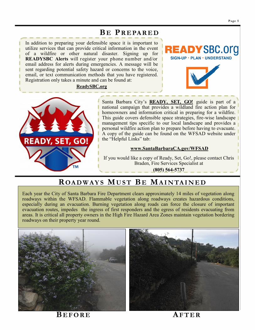
R OA D W A Y S M U S T B E M A I N TA I N E D
Each year the City of Santa Barbara Fire Department clears approximately 14 miles of vegetation along roadways within the WFSAD. Flammable vegetation along roadways creates hazardous conditions, especially during an evacuation. Burning vegetation along roads can force the closure of important evacuation routes, impedes the ingress of first responders and the egress of residents evacuating from areas. It is critical all property owners in the High Fire Hazard Area Zones maintain vegetation bordering roadways on their property year round.
B E F O R E A F T E R
Page 6 2021
T H E C O M M U N I T Y F U E L S T R E A T M E N T N E T W O R K
V E G E TA T I O N M A N A G E M E N T
Over the past three years, Vegetation Management projects have been
primarily focused within the Community Fuels Treatment Network
(CFTN), including the Las Canoas, West Mountain, Skofield Park and
St. Mary’s areas. The CFTN is an area that ties together fuel
reduction projects completed by Santa Barbara City, Montecito and
Santa Barbara County.
Focusing vegetation management projects in these areas provides a
break between continuous stands of chaparral fuel outside the City
boundary and the City area. Once completed, these project areas
provide a strategic last line of defense for fire protection resources to
suppress a wildland fire before it enters more highly populated areas
of the City.
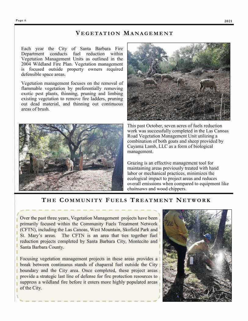
Each year the City of Santa Barbara Fire Department conducts fuel reduction within Vegetation Management Units as outlined in the 2004 Wildland Fire Plan. Vegetation management is focused outside property owners required defensible space areas.
Vegetation management focuses on the removal of flammable vegetation by preferentially removing exotic pest plants, thinning, pruning and limbing existing vegetation to remove fire ladders, pruning out dead material, and thinning out continuous areas of brush.
This past October, seven acres of fuels reduction work was successfully completed in the Las Canoas Road Vegetation Management Unit utilizing a combination of both goats and sheep provided by Cuyama Lamb, LLC as a form of biological management.
Grazing is an effective management tool for maintaining areas previously treated with hand labor or mechanical practices, minimizes the ecological impact to project areas and reduces overall emissions when compared to equipment like chainsaws and wood chippers.
Wildland Fire Suppression Assessment Distr ict Page 7
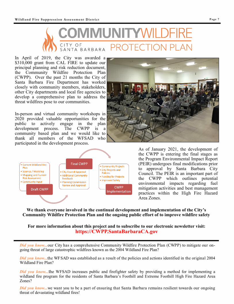
In April of 2019, the City was awarded a $310,000 grant from CAL FIRE to update our principal planning and risk reduction document, the Community Wildfire Protection Plan (CWPP). Over the past 21 months the City of Santa Barbara Fire Department has worked closely with community members, stakeholders, other City departments and local fire agencies to develop a comprehensive plan to address the threat wildfires pose to our communities.
In-person and virtual community workshops in 2020 provided valuable opportunities for the public to actively engage in the plan development process. The CWPP is a community based plan and we would like to thank all members of the WFSAD who participated in the development process.
As of January 2021, the development of the CWPP is entering the final stages as the Program Environmental Impact Report (PEIR) undergoes final modifications prior to approval by Santa Barbara City Council. The PEIR is an important part of the CWPP which outlines potential environmental impacts regarding fuel mitigation activities and best management practices within the High Fire Hazard Area Zones.
We thank everyone involved in the continual development and implementation of the City’s Community Wildfire Protection Plan and the ongoing public effort of to improve wildfire safety
Did you know...our City has a comprehensive Community Wildfire Protection Plan (CWPP) to mitigate our on-going threat of large catastrophic wildfires known as the 2004 Wildland Fire Plan?
Did you know...the WFSAD was established as a result of the policies and actions identified in the original 2004 Wildland Fire Plan?
Did you know...the WFSAD increases public and firefighter safety by providing a method for implementing a wildland fire program for the residents of Santa Barbara’s Foothill and Extreme Foothill High Fire Hazard Area Zones?
Did you know...we want you to be a part of ensuring that Santa Barbara remains resilient towards our ongoing threat of devastating wildland fires!
For more information about this project and to subscribe to our electronic newsletter visit:
Ju s t sna p t he ab o ve QR co d e w i t h y our sma r t p ho ne a n d i t w i l l t ak e y o u t o o u r s i g n u p f o r m. Yo u wi l l be co n tac t e d t o
s e t u p a n app o i n t me n t w i t h in 1 - 2 b u s i ne s s d ay s . Yo u c an a l so v i s i t :
www.Sa nt a Ba r bar a CA.go v / WF SAD
L o o k fo r De fe n s ib l e Sp ace E va l u a t i o ns
u n d e r t he Se r v i c e s t ab .
SIGN UP FOR A FREE DEFENSIBLE SPACE EVALUATION
YOUR ASSESSMENT DOLLARS PROVIDE FOR:
Vegetation Management Projects • Defensible Space Evaluations • Vegetation Chipping
Public Education & Outreach • Vegetation Road Clearance