+ All Categories
Home > Documents > WAKEHAM PROJECT TECHNICAL REPORT

WAKEHAM PROJECT TECHNICAL REPORT

Date post: 04-Feb-2022
Category:
Upload: others
View: 1 times
Download: 0 times
Share this document with a friend
35
1 1. Title page Technical Report on the Wakeham Uranium Project In accordance with National Instrument 43-101 Submitted to Bearclaw Capital Corp. Rémi Charbonneau, Geologist, Ph.D,, OGQ permit #290 and Isabelle Robillard Geologist, M.Sc., OGQ permit #287 June 2007
Transcript

1

1. Title page

Technical Report on the

Wakeham Uranium Project In accordance with

National Instrument 43-101

Submitted to Bearclaw Capital Corp.

Rémi Charbonneau, Geologist, Ph.D,, OGQ permit #290

and

Isabelle Robillard Geologist, M.Sc., OGQ permit #287

June 2007

2

2. Table of Contents 1. Title page ........................................................................................................................ 1 2. Table of Contents............................................................................................................ 2

List of Figures ................................................................................................................. 3 List of Tables .................................................................................................................. 3 Appendix I ...................................................................................................................... 3

3. Summary ......................................................................................................................... 4 4. Introduction and terms of reference................................................................................ 5 5. Reliance on Other Experts .............................................................................................. 5 6. Property description and location ................................................................................... 5 7. Accessibility, Climate, Local Resources, Infrastructure and Physiography................... 6 8. History............................................................................................................................. 7

8.1. Geological Mapping................................................................................................. 7 8.2. Mineral occurences .................................................................................................. 7 8.3. Uranium exploration (1967-1969) ........................................................................... 7 8.4. Uranium exploration (1978) .................................................................................... 8 8.5. Recent exploration ................................................................................................... 8

9. Geological Setting........................................................................................................... 8 9.1 Property Geology ...................................................................................................... 9 9.2 Lac Cimon and lac Buit Claims ................................................................................ 9 9.3 Hayman Claims......................................................................................................... 9 9.4 Rivière Romaine Claims ........................................................................................... 9 9.5 Lac Boucher and 12L06 claims ................................................................................ 9

10. Deposit Types ............................................................................................................. 10 10.1 Unconformity type ................................................................................................ 10 10.2 Other deposit types ............................................................................................... 10 10.3 Exploration strategy .............................................................................................. 11

11. Mineralization ............................................................................................................. 11 12. Exploration.................................................................................................................. 12 13. Drilling........................................................................................................................ 12 14. Sampling Method and Approach ................................................................................ 12 15. Sample preparation, Analyses and Security................................................................ 12 16. Data verification.......................................................................................................... 12 17. Adjacent Properties..................................................................................................... 12 18. Mineral Processing and Metallurgical Testing ........................................................... 12 19. Mineral Resources and Mineral Reserve Estimates.................................................... 13 20. Interpretation and Conclusions ................................................................................... 13 21. Recommendations....................................................................................................... 14 23. References................................................................................................................... 15 24a. Certificate of Authors................................................................................................ 17 24b. Date and signatures ................................................................................................... 19 25 : Additional requirements ............................................................................................ 20 26. Illustrations ................................................................................................................. 20

3

List of Figures Figure 1. Location of the project area.............................................................................. 21 Figure 2. Generalized Geology ........................................................................................ 22 Figure 3. Claim-block maps (3a northen part, 3b southern part, 3c legend) .............. 23-25

List of Tables Table 1. List of claim blocks.............................................................................................. 6 Table 2. List of the known showings ............................................................................... 11 Table 3. Detailed costs for proposed non-contingent Phase I.......................................... 14 Table 4. Detailed costs for proposed Phase II.................................................................. 14

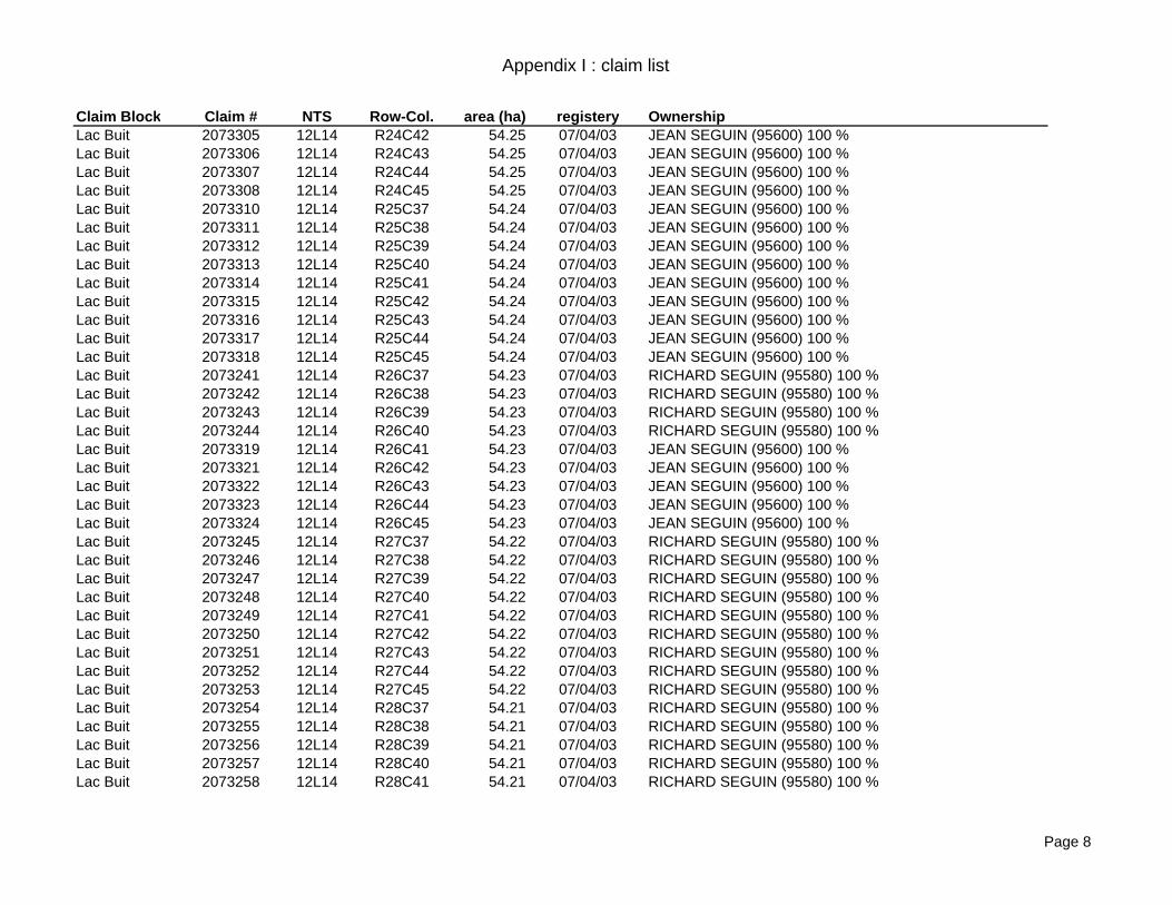
Appendix I Claim List

4

3. Summary The Property is made up of 358 claims (map-staking cells) for a total area of 17 953 ha. It is located on the Québec north shore, between 30 to 80 km north of Baie Johan-Beetz. It includes six claim blocks identified as Lac Buit, Lac Cimon, Hayman, Rivière Romaine, Lac Boucher and Sheet 12L06. Access to the properties is by helicopter or fixed wing float plane from Havre Saint-Pierre or Baie Johan-Beetz. Very limited mineral exploration works have been conducted on the project area. These include U exploration by Johan Beetz Syndicate who concentrated their effort near the Saint-Lawrence shore from 1967 to 1969. Some areas were covered by airborne radiometry during that period, leading to the discovery of several anomalies. Some of these anomalies are close to two claim blocks of the Property and were not further investigated. More recently, Soquem performed a ground reconnaissance for base metal in the southern part of the present Project area leading to the discovery of two additional Cu showings. Active exploration programs for U are taking place on nearby claims, for Rössing type uraniferous pegmatite in younger intrusive. The project was initiated by the Dresden Sugarhill Group who recently staked favourable geological contexts within the western part of the Wakeham Basin. Bearclaw Capital Corp. has entered into a non-binding letter of intent to acquire a 100% interest in the 358 claims. The geological context includes poorly metamorphosed sandstones and mudstones of the Wakeham basin in contact with paragneiss and orthoquartzite on its border. The basin is mostly surrounded by younger intrusives of granite and syenite plutons and a large anorthosite batholith on the west. Glacial geology is characterized by a discontinuous till veneer form under SSE to SSW ice flows. Possible deposits type includes unconformity (U), U-pegmatites of the Rössing type, Keruna - Olympic Dam (Cu-Au-U-REE) stratiform U-Cu and skarn (Cu). At present time, Cu, Ag showings related to skarn or unconformity type occur on the property. Although the unconformity type represents the main model to be tested, the regional geological context is particularly complex. Therefore, the application of a systematic airborne radiometric survey which will find any surface occurrence of uranium remains the best way to test these models. An exploration program including a non-contingent first phase of airborne geophysics combining radiometric, magnetic and EM measurement with an operating budget of $273 000 is proposed. A second phase of ground follow-up, conditional on the success of phase I in generating a significant anomaly, is recommended with a budget of $198 000.

5

4. Introduction and terms of reference The present document reports a general description and geological information regarding the Wakeham project of Bearclaw Capital Corp (Bearclaw) on the North Shore Region of Quebec. It is presented in compliance with the National Instrument 43-101. Bearclaw’s business is the acquisition, exploration and development of mineral properties. The issuer (Bearclaw) is proposing to conduct a staged exploration program for uranium on six claim blocks located between 30 and 80 km north of Havre-Saint-Pierre in the middle North Shore, Québec. Bearclaw is a reporting issuer in Alberta and British Columbia. The property is presently at low exploration stage. It is understood that this report will be used to provide disclosure to Bearclaw’s Board of Directors and to support Bearclaw’s future financing activities, and that it will be provided to the TSX Venture Exchange in support of Bearclaw’s application for approval of the proposed acquisition of the Property. To prepare this report, data was obtained from public domain geological reports and maps, internal files and report provided by Dresden Sugarhill Group and personal communication with its representative, Mr. É. Séguin, Geologist. The first author, RémiCharbonneau, visit the property on june 25th 2007. The authors were not involved in this project prior to the writing of this report.

5. Reliance on Other Experts Land tenure information of staked mining claims was obtained from the Québec Ministry (Gestim informatic system). The map staking cells are registered for all six claim blocks.

6. Property description and location The Wakeham Property is located in the North Shore Region of Québec, some 300 km east of Sept-Iles (Figure 1). It is covered by NTS map sheets 12L06, 12L11 and 12L14 (scale 1 : 50 000). The whole property consists of 358 claims (CDC) with a total area of 17 953 hectares (Appendix I) and forms six distinct claim blocks (Table 1).

6

Table 1. List of claim blocks Name Number of CDC Area (ha) Lac Buit 63 1945.165 Lac Cimon 38 2056.511 Hayman 74 4006.829 Riv. Romaine 102 5534.751 Lac Boucher 71 3863.475 12L06 10 546.2911

Appendix I lists the claim numbers, locations, area, date of registration and registered owner of the claims that make up the six claims blocks. As discussed above, Bearclaw has entered into a non-binding letter of intent to acquire a 100% interst in the 358 claims forming the six claim blocks.

7. Accessibility, Climate, Local Resources, Infrastructure

and Physiography The claims blocks defining the property are located along a north-south axis which is roughly aligned along the Romaine River, halfway between the villages of Havre-Saint-Pierre to the west and Baie-Johan-Beetz to the east (Figure 1). The claim blocks are located from 30 to 90 km away from the north shore of Saint-Lawrence Gulf. The economic activity of the region is dominated by fishing and the population is therefore concentrated in small villages, distributed along the North shore, 15 to 60 km apart. Road 138 which is maintained year round connects all these villages to Natasquan. All claim blocks are accessible by hydroplane from Havre-Saint-Pierre or Baie-Johan-Beetz, where labour, housing and various services are available. Sept-Iles, the site of the shipping terminal of Iron Ore Company of Canada, is a deep water seaport located some 300 km west of Baie-Johan-Beetz. The Lac Tio ilmenite deposit is located some 20 km west of the southernmost claim blocks (Sheet 12L06 and Lac Boucher). A railway connects the Lac Tio mine to Havre Saint-Pierre. The regional climate is subpolar and relatively humid. Total annual precipitation is 1100 mm. The ground is free of snow from mid-June to October. Hydrography is well developed with abundant streams and small size lakes generally entrenched in deep valleys. The topography is characterised by low steep-sided hills with a maximum altitude of 650 m. Forest cover is dominated by black spruces and becomes more open with lichens on top of plateaus.

7

8. History The project was initiated by Émilien Séguin, Geologist of the Dresden Sugarhill Group who recently staked favourable geological targets within the western part of the Wakeham Basin. The area was selected because of the presence of a huge Proterozoic sedimentary basin which had not been intensely covered by U exploration. Previous works are described in the following sections. 8.1. Geological Mapping The region underwent several geological studies at different scales since 1940. Reconnaissance geological mapping was performed in the western part of the Wakeham Basin (Retty 1944, Longley 1948, Claveau 1949) and a geological mapping 1 : 250 000 was performed by Sharma and Franconi (1975). Recent geological studies in the region contributed to a better understanding of this rather complicated sector of the Grenville Province (Indares and Martignole, 1994; Verpaelst et al., 1999). 8.2. Mineral occurences Exploration work was very scarce in the region and, as a consequence, most of the Cu showings were found during geological mapping by the Ministère des Ressources. Geological mapping of the Sanson lake area (Retty 1944) led to the discovery of the most interesting copper showings. Chalcopyrite was observed in place at six localities in the area and in float at one other locality. Theses occurrences are either in sedimentary rocks of Grenville age or in association with the ubiquitous gabbro or meta-gabbro bodies. At Sanson Lake, a 300 m. band of amphibolite lies within an area that is underlain by alternating patches of granite and paragneiss. Just above the outlet, on the east side of the lake, the amphibolite is traversed by a quartz vein with a considerable amount of chalcopyrite. The vein is exposed for a length of 2.6 m. and is nearly 0.3 m wide and strikes NW into the lake (Retty 1944, Verpaelst et al. 1999). 8.3. Uranium exploration (1967-1969) From 1967 to 1969 the region underwent a period of relatively intense mineral exploration for uranium. Exploration work was concentrated in the Johan-Beetz area and in the Lac à l’Ours region, in Tetu Township. Of particular interest, an airborne radiometric survey was performed in 1967 in the Bassin des Murailles area, next to the south limit of the lac Boucher claim block (Bergman, 1968). Three anomalic areas were defined and are reported to be distributed with some continuity in a northerly direction, i.e. toward the actual lac Boucher claim block. In addition, the Johan Beetz Syndicate performed a large scale radiometric survey on the region in 1967 (Scott, 1968). This work resulted in a radiometric anomaly found in the lake Sanson area along Ruisseau Lebrun, immediately south of the Heyman Claims. The area was immediately staked as this

8

anomaly was classified as a high priority. However, no further investigation was reported for this anomaly. In their report, they states that the radiometric survey was initiated after the discovery of an uraniferous pegmatite in the Courtemanche County (1.4 lb U3O8 / ton) and that this content was used as a threshold for an anomaly to be considered. The author reported that 41 anomalies were found but all of these were not staked, nor detailed in their report. 8.4. Uranium exploration (1978) Further exploration work for uranium was undertaken at the end of the 1970’s by Urangesellscaft in the region of Lac à l’Ours (Mackie, 1978). Geologic, radiometric and geochemical surveys as well as two trenches were undertaken on a grid area located some 13 km south east of claim block sheet 12L/06. Anomalous areas were mostly found in pegmatitic granites and occasionaly in a highly granitized metasediment. Out of the 84, 10 kg samples analysed, a maximum value of 566 ppm U was reached in one of the trench in a pink, medium grained aplite. 8.5. Recent exploration Very little exploration work has been undertaken in the area over the last 25 years. Most of the work done in the 1990’s was under a Quebec Government prospector help program (volet A-1) which is of very limited extent. The only exception is an exploration program by Soquem in the Nobel Lake area (Roy, 2003) searching for a stratiform Cu deposit. This work led to the discovery of two Cu showing at the contact of younger granite, ascribed to skarn type of mineralization. Finally, a study was conducted by Genest (2000) for the evaluation of uranium potential of the Wakeham Basin. This geological review, assisted by regional field work, concluded that the Olympic Dam type represents the best potential in this region.

9. Geological Setting The property is located in the east section of the Grenville structural Province, at the western margin of Wakeham Basin. This proterozoic sedimentary Basin of 8100 km2 was divided by Indares and Martignole (1993) in two Groups: the Aguanus group, located in the east portion of the basin and considered as being the base of basin and the Davy Group, in the west part of the Basin. The Aguanus group consists of arenites, gabbro sills, rhyolites and basalts. Detrital and rhyolitic sequences of the Aguanus Group were dated at 1270 Ma (Indares and Martignole, 1993). The Davy group comprises detrital formations alternating with gabbro sills. The presence of siliciclastite and volcanic rocks in the Aguanus Group is the main distinctive feature between the two Groups. Verpaelst et al. (1999) later questioned this subdivision and considered all of the sedimentary and volcanics units as part of the Wakeham Group.

9

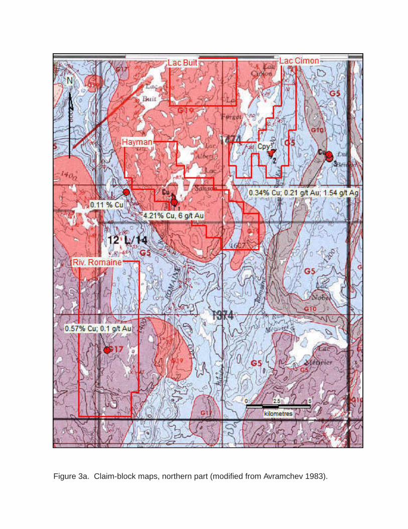
The Wakeham Basin is hosted in charnockitcic gneiss and heterogeneous felsic rocks to the east and in the Havre Saint-Pierre Complex to the west. This complex includes the anorthosite batholith with a charnockite-mangerite envelope. The Anorthositic complex of Havre Saint-Pierre holds a number of ilmenite and magnetite deposits of varying dimensions. Transitional lithologies between the Wakeham Basin and the anorthositic suite of Havre-Saint-Pierre were identified as the “complexe de Buit” (Verpaelst et al. 1999). It includes paragneiss and foliated, felsic intrusives. 9.1 Property Geology Lithological assemblages observed in the six claim blocks forming the property are dominated by Wakeham paragneiss and plutonic rocks. Paragneiss mapped along Romaine river, just west of Buit lake are well-layered very fine grained, light to dark grey paragneisses interbedded with pure to impure quartzites and bands of amphibolite. It shows very well developed mineral lineation of biotite and also contains quartz, plagioclase and amphibole as main minerals with some garnets (Sharma and Franconi, 1975). The Wakeham Group paragneisses differ from the mixed paragneisses by their thin heterogeneous nature and by frequent association with interbedded quartzite and sills of gabbro. They present a lower metamorphism grade (greenschist as opposed to amphibolite). 9.2 Lac Cimon and lac Buit Claims Lac Cimon Block is dominated by semipelitic paragneiss composed of garnet quartzites and amphibolites (Figure 3a). On the west shore of Forget Lake, these formations are cut with numerous veins of quartz and white pegmatites as well as quartz-rich pegmatite (Indares and Martignole 1993). These were also described as mall size pegmatitic intrusives near Sanson Lake and Buit Lake (Verpaelst et al. 1999). Lac Buit Block resides in a large granite intrusive (Figure 4) that contains many inclusions of the semipelitic paragneiss. This semi pelitic paragneiss becomes more abundant westward and, in the vicinity of lac Buit, the paragneiss appear only in the form of scattered enclaves, dispersed in a heterogeneous granite. 9.3 Hayman Claims This Block covers two large occurrences of paragneiss included in the granite instrusive of the Lac Buit (Figure 3a). It includes two close showings including 4.21% Cu and 6 g/t Au. These, referred to as Hayman or Lake Sanson showings, were discovered by Retty (1944). They occur within the paragneiss units. 9.4 Rivière Romaine Claims Large units of paragneiss occur in contact with syenite at the Rivère Romaine claim block (Figure 3a). One of these paragneiss occurrences hosts the Romaine 2 Cu-Au showing. 9.5 Lac Boucher and 12L06 claims Small amounts of grey gneiss and granitic gneiss are mapped in the southernmost claim blocks (Figure 3b). These rocks represent Archean rocks which constitutes remnants of

10

the original basement. Grey gneisses contain varying amounts of mobilizate. They appear as a light to dark grey, homogeneous to heterogeneous, medium grained, well foliated rock containing quartz feldspar and biotite-hornblende, with occasional potash feldspar and pyroxene. They are small occurrences (Sharma and Franconi 1975) and are associated with grey gneiss.

10. Deposit Types The main deposit model to be tested at the Wakeham Project is the unconformity type of U deposit, although attractive other types like Olympic-Dam type (Clark and Gobeil, 1992; Genest, 2000), stratiform U-Cu-Zn or pegmatite of the Rössing type represent possible models. Nevertheless, an exploration approach based on airborne radiometry will detect any surface occurrences of U, if present, independently of the assumed genetic model. 10.1 Unconformity type Uranium deposits mined in the Athabaska basin consist of massive to semi-massive pechblende concentrated in faults zones, near or at the unconformity between the basement archean rocks and the sedimentary basin. Therefore, a close spatial relationship between archean crystalline rocks of the basement and the clastic sedimentary rocks of the upperlying proterozoic basin is required for this type of deposit (Ruzicka, 1996). In addition, the occurrence of faults, shear zones and fracture zones are necessary for the circulation of dissolved uranium. The uranium will precipitate according to specific oxydo-reduction conditions. In the Wakeham basin, however, it is difficult to pin point the basal contact of the basin since most of the peripheral intrusives are younger than the basin itself. Consequently, the paragneiss that border that basin is locally interpreted as contact metamorphism of the Wakeham group by these instrusives (Indarès and Martignole 1993, Verpaelst et al. 1999). Moreover. the possibility that the overall basin was displaced by faulting has been invoked (Verpaelst et al. 1999). In consideration of these somewhat contradicting conceptual models, efficient prospecting of the basin for U represents the best way to clarify the situation. 10.2 Other deposit types The possibility of magmatic Olympic-Dam – Keruna Cu U Au REE mineralization type has been proposed for the Wakeham basin by Clark and Gobeil (1992) and reiterated by Genest (2000). A continental rift environment, felsic volcano-plutonic hosted rocks and alkalic to subalkalic magmatism are proposed as good indicators of a favourable geological context. Characteristic geochemical signatures (Ba, REE, F, Mo, PB, Sr Th, U, Y and Zn) present in lake sediments collected in the north part of the Wakeham Basin are also noted (Clark and Gobeil 1992). Such an iron oxide magmatic system has been identified NE of Sept-Iles (Cayer 2001, Gauthier et al., 2004) and may be present on the Property.

11

Uraniferous pegmatites of the Rössing type (Berning et al. 1976) may also be present since this model involves the heating of the base of a sedimentary pile causing its partial fusion and the emplacement of mineralized pegmatite at a higher level within the pile (as examplified in Gauthier and Larocque 1998). This situation is clearly applicable to the Wakeham basin, particularly in its peripheral parts where younger intrusions are present. 10.3 Exploration strategy Previous geological studies have revealed a complex geology where uranium targets cannot be selected on the basis of favourable contacts or geological structures only. For this reason, the proposed exploration strategy is to first perform an airborne survey to detect radiogenic sources. Secondly, the identified anomalies will be visited and verified on the field by the use of a hand scintillometer. At this stage, the radiogenic rock source can be identified and described on outcrop or surface boulders and sampled for lithogeochemical analysis. One or many of the considered conceptual model of U enrichment will be subsequently confirmed from the geological context. In the case of a mineralized float, boulder tracing techniques should be applied to pin point the bedrock source.

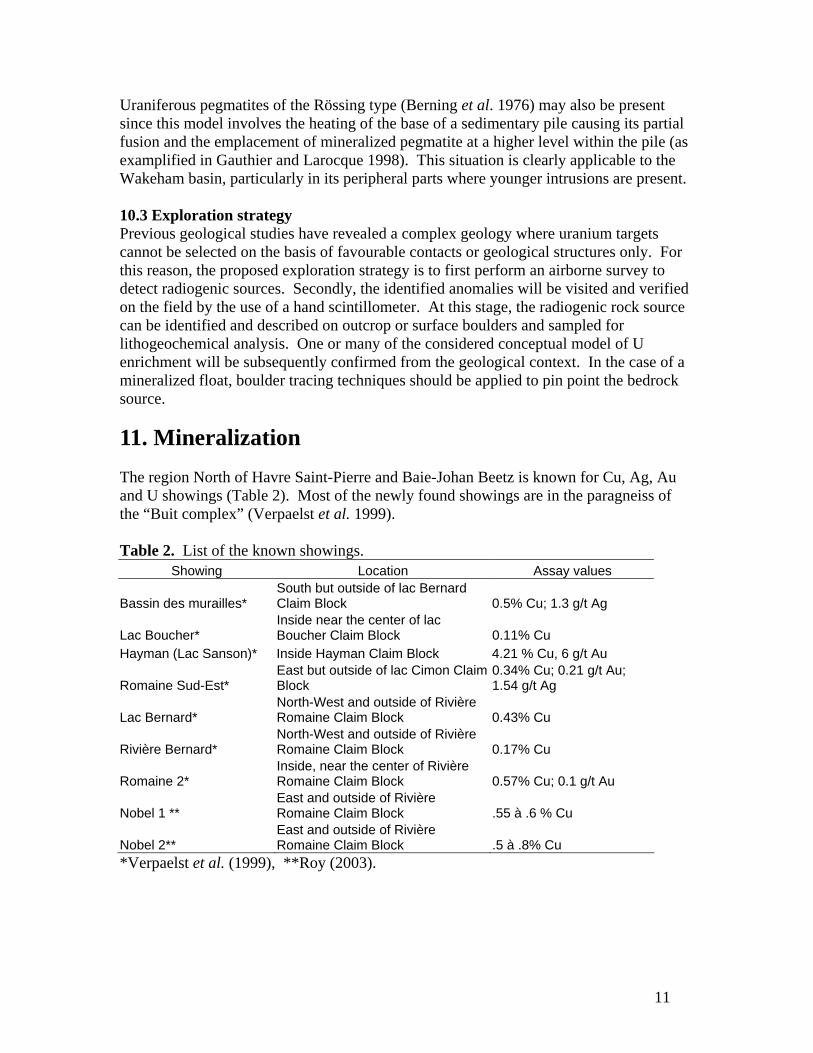
11. Mineralization The region North of Havre Saint-Pierre and Baie-Johan Beetz is known for Cu, Ag, Au and U showings (Table 2). Most of the newly found showings are in the paragneiss of the “Buit complex” (Verpaelst et al. 1999). Table 2. List of the known showings.

Showing Location Assay values

Bassin des murailles* South but outside of lac Bernard Claim Block 0.5% Cu; 1.3 g/t Ag

Lac Boucher* Inside near the center of lac Boucher Claim Block 0.11% Cu

Hayman (Lac Sanson)* Inside Hayman Claim Block 4.21 % Cu, 6 g/t Au

Romaine Sud-Est* East but outside of lac Cimon Claim Block

0.34% Cu; 0.21 g/t Au; 1.54 g/t Ag

Lac Bernard* North-West and outside of Rivière Romaine Claim Block 0.43% Cu

Rivière Bernard* North-West and outside of Rivière Romaine Claim Block 0.17% Cu

Romaine 2* Inside, near the center of Rivière Romaine Claim Block 0.57% Cu; 0.1 g/t Au

Nobel 1 ** East and outside of Rivière Romaine Claim Block .55 à .6 % Cu

Nobel 2** East and outside of Rivière Romaine Claim Block .5 à .8% Cu

*Verpaelst et al. (1999), **Roy (2003).

12

12. Exploration The issuer has recently entered into a non-binding letter of intent with the owners of the claims and has not yet undertaken any exploration program.

13. Drilling The issuer has not conducted any drilling program in the properties.

14. Sampling Method and Approach The issuer has not designed any exploration program on the properties and sampling methods and approaches have yet to be defined. Of course, lithogeochemical sampling should be assisted by the use of a hand scintillometer.

15. Sample preparation, Analyses and Security The issuer has not determined the appropriate methods for sample preparation, analyses and security for any future exploration programs.

16. Data verification The data presented here is the result of a literature review. Confirmation and better localisation of the material discussed in section 8 can be obtained by a detailed compilation of the available data.

17. Adjacent Properties Ongoing exploration in the area in the form of follow up on lake sediment sampling has been reported (Azimuth Press Release August 31th, 2006).

18. Mineral Processing and Metallurgical Testing No metallurgical study of mineralization located on the project area has been commissioned by the issuer.

13

19. Mineral Resources and Mineral Reserve Estimates The properties have not been subjected to any resource calculations.

20. Interpretation and Conclusions The Wakeham Uranium project remains at the reconnaissance stage. Its interest resides in a conceptual context favourable for the finding of economic uranium deposits associated with either unconformity, iron oxide, pegmatite or hydrothermal systems. Limited exploration work for uranium including some scattered airborne radiometric grid was conducted in the past, mostly south of the Project area. These led to interesting radiometric anomalies which are still apparently untested, thus confirming the U potential of the Basin. However, independently of the ore forming model, the application of a systematic radiometric airborne survey remains as the best way to reveal surface occurrences of uranium mineralization.

14

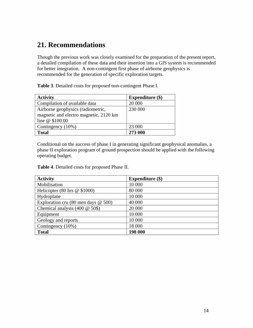
21. Recommendations Though the previous work was closely examined for the preparation of the present report, a detailed compilation of these data and their insertion into a GIS system is recommended for better integration. A non-contingent first phase of airborne geophysics is recommended for the generation of specific exploration targets. Table 3. Detailed costs for proposed non-contingent Phase I. Activity Expenditure ($) Compilation of available data 20 000 Airborne geophysics (radiometric, magnetic and electro magnetic, 2120 km line @ $100.00

230 000

Contingency (10%) 23 000 Total 273 000 Conditional on the success of phase I in generating significant geophysical anomalies, a phase II exploration program of ground prospection should be applied with the following operating budget. Table 4. Detailed costs for proposed Phase II. Activity Expenditure ($) Mobilisation 10 000 Helicopter (80 hrs @ $1000) 80 000 Hydroplane 10 000 Exploration cru (80 men days @ 500) 40 000 Chemical analysis (400 @ 50$) 20 000 Equipment 10 000 Geology and reports 10 000 Contingency (10%) 18 000 Total 198 000

15

23. References

Avramtchev, L., 1983, Carte des gites minéraux du Québec : région de la Côte-Nord;

DV83-14, 19 p, 26 maps.

Bergmann, H. J., 1968, Preliminary report on Johan Beetz Project; GM21839, 20 p, 26

maps.

Berning, J., Cooke, R., Hiemstra, S.A., Hoffman, U., 1976, The Rössing uranium

deposit, southwest Affrica; Economic Geology, v. 71, p. 351-368.

Cayer, A., 2001, Caractérisation minéralogique des lithologies, des altérations et des

minéralisations d'oxydes de fer, de cuivre et de terres rares de la propriété

Kwyjibo, Côte-Nord (Québec), Province géologique de Grenville: Université

du Québec à Montréal, Unpublished M.Sc. thesis, 71 p.

Clark, T., and Gobeil, A., 1992, Potential of the Wakeham terrane for Olympic Dam-

type Cu-U-Au-Ag deposits and sandstone-hosted Pb-Zn deposits; PRO 92-06,

7 p.

Claveau, J., 1949, La région du lac Wakeham, Compté de Saguenay, Ministère des

mines, Québec; Rapport Géologique 37, 57 p.

Gauthier, M., Chartrand, F., Cayer, A., and David, J., 2004, The Kwyjibo Cu-REE-U-Au-Mo-F property, Quebec: A Mesoproterozoic polymetallic iron oxide deposit in the Northeastern Grenville Province: Economic Geology, v. 99, p. 1177-1196.

Gauthier, M., and Larocque, M., 1998, Cadre géologique, style et répartition des

minéralisations métalliques de la Basse et Moyenne Estmain, Territoire de la

Baie James; Ministères des Ressources Naturelles du Québec, MB98-10, 86 p.

Genest, S. and Bruneton, P., 2000, Bassin de Wakeham: reevaluation du potentiel

uranifère; GM59202, 106 p.

Indares, A., and Martignole, J., 1993, Étude régionale du supergroupe de Wakeham-

Moyenne-Côte-Nord., MB 91-21, 73 p, 2maps (scale 1:50 000) and 1 map

(scale 1:500 000).

16

Longley, W.W., 1948, Région du lac Forget, Compté de Saguenay ; Ministère des Mines

du Québec, Rapport Géologique 36.

MacKie, B., 1978, Report on geologic radiometric, geochemical surveys and trenching

program, lac à l’Ours Project K-10., GM 33622, 24 p., 22 map.

Retty, J . A., 1944, Région de la rivière romaine inférieure, Comté de Saguenay.

Ministère des Mines, Québec; RG19, 32 p.

Roy, I., 2003, Rapport sur les travaux d’exploration 1999 et 2000, secteur lac Nobel, projet Lac Davy; GM59989, 27 p. 2 maps.

Ruzicka, V., 1996, Gîtes d’uranium associés à des discordances. In: Geology of Canadian Mineral Deposit Types, Geol. Surv. Can., Geology of Canada, no. 8, p.219-234.

Scott, F., 1968, Preliminary report on Johan Beetz Project; GM22435, 20 p, 26 maps.

Sharma, K. N. M. and Franconi, A., 1975, Magpie, Saint-Jean and Romaine River

Areas, Geological Report 163, 71 p.

Verpaelst, P., Madore, L., Brisebois, D., Hocq, M., Dion, D-J., Lavallée, G. and

Choinière, J., 1999, Géologie des régions du lac Jérôme, du lac Sanson et de

la petite rivière de l’Abbé-Huard (12L/13, 12L/14, 12M/03) ; RG98-02, 38 p.

17

24a. Certificate of Authors I, Rémi Charbonneau, residing at 7667 Chateaubriand street, Montreal, Quebec, hereby certify that: I am presently an Associate of Inlandsis Consultants s.e.n.c. located at 7667 Chateaubriand Ave., Montreal, Quebec, H2R 2M2. I received a B.Sc. in Geology from the University of Montreal in 1986 and a Ph.D. degree in Glacial Geology in 1995 from the same institution. I have been working as a geologist in mineral exploration since 1995. I am an active Professional Geologist presently inscribed to the board of the Ordre des Geologues du Quebec, permit # 290. I am a qualified person with respect to the Wakeham Uranium Project in accordance with the specifications described in section 1.1 of the national instrument 43-101.

I have had no prior involvement with the properties that are the subject of the Technical Report titled “technical report on the Wakeham Uranium Project” prepared for Bearclaw Capital Corp. I am responsible for items 1 to 5, 11 and 20 to 23 of the present Technical Report on the Wakeham Uranium Project, dated of June 2007, in collaboration with the second author and I prepared the illustrations. As of the date of this Certificate, to the best of my knowledge, information and belief, the Technical Report contains all scientific and technical information that is required to be disclosed to make the technical report not misleading. I fulfill the requirements set out in the National Instrument 43-101 for an « independent qualified person » relative to the issuer.

I visited the Property on June 25, 2007. I read and used National Instrument 43-101 and Form 43-101F1 to make the present report in accordance with its specifications and terminology.

I consent to the filing of the Technical Report with any stock exchange and other regulatory authority and any publication by them for regulatory purposes, including electronic publication in the public company files on their website accessible by the public, of the Technical Report.

18

I, Isabelle P. Robillard, residing at 7669 Châteaubriand Ave. Montréal, Québec do hereby certify that:

I am an associate exploration geologist of Consultants Inlandsis s.e.n.c.

I graduated with a Bachelor of Science degree in Geology from the University of Montréal in 1987 and completed a Master degree in Geology in 1990 at McGill University.

I am a Professional Geologist presently registered with permit # 287 on the board of Ordre des Géologues du Québec.

I have worked as a geologist since my graduation from university and as a exploration geologist since 1998, as an associate of Consultants Inlandsis s.e.n.c.

I fulfill the requirements to be a ‘qualified person’ for the purposes of National Instrument 43-101. I am responsible for items 6 to 10 and 12 to 19 of the present Technical Report on the Wakeham Uranium Project dated of June 2007 in collaboration with the first author and I supervised the illustrations.

I have had no prior involvement with the properties that are the subject of the Technical Report titled “Technical report on the Wakeham Uranium Project” prepared for Bearclaw Capital Corp.

I did not visit the Property.

I acknowledge that as of the date of the certificate, and to the best of my knowledge, information and belief, the Technical Report contains all scientific and technical information that is required to be disclosed to make the Technical Report not misleading.

I am independent of the issuer applying all of the tests set in NI 43-101.

I have read NI 43-101 and Form 43-101F, and the Technical Report has been prepared in compliance with that instrument and form.

I consent to the filing of the Technical Report with any stock exchange and other regulatory authority and any publication by them for regulatory purposes, including electronic publication in the public company files on their website accessible by the public, of the Technical Report.

19

24b. Date and signatures June, 28th 2007 << Rémi Charbonneau >> Rémi Charbonneau, Geologist, Ph.D., OGQ permit #290 << Isabelle Robillard >> Isabelle Robillard, Geologist, M.Sc., OGQ permit #287

20

25 : Additional requirements regarding the development

of Property and production on the Property There are no development or production plans for this property in the near future.

26. Illustrations

(

(

(

(( (

(

(

(

(

(

(

(

(

(

(

(

(

(

(

(

((

(

((

(

(

(

(

(

(

((

(

(

(

((

(

(

(

((

((

(

(

(

(

(

(

(

(

(

(

((

(

(

((

(

((

(

(

(

((((

(

(

(

((

( (

(

(

(

(

( ((

( ( ((

(

(

(

(

(

(

(

(

((

(

(

(

RéservoirManicouagan

N

Québec

Labrador

ProjectArea

0 50

kilometres

Golfe duSaint-Laurent

100

Havre-Saint-Pierre

Baie-Johan-Beetz

Gaspé

Sept-Îles

Matane

Figure 1. Location of the project area.

WakehamBasin

AN = AnorthositeBA = BasaltGB = Gabbro

OQ = OrthoquartziteGN = GneissPG = Paragneiss

GR = GraniteSY = SyeniteMG = Migmatite

N

Lithology

kilometres

500 25

GR

PG

GR

PG

AN

OQ

SY

GN

GN

OQGN

GN

GN

GB

PG

BA

Lac Buit

Hayman

Lac Cimon

12L06

Lac Boucher

Riv. Romaine

PG

MG

MG

MG

GN

OQ

GB

GB

GB

SY

SY

GR

GR

BA

BA

GB GN

BA

GN

SY

R

Figure 2. Generalized geology showing the location of the claim blocks relative to the Wakeham Basin.

Figure 3a. Claim-block maps, northern part (modified from Avramchev 1983).

Figure 3b. Claim-block maps, southern part (modified from Avramchev 1983).

Gneiss complex

Granitic gneiss

Paragneiss, amphibolite

Anorthosite

Gabbro

Gabbro, amphibolite

Mangerite

Monzonite

Syenite

Diatectic granite

Granite with pegmatite

Migmatite

Fault orshear zone

Micro-foldaxis

Foliation

Geologicalcountour

Outcrop

Figure 3c. Legend for claim-block maps (Figures 3a and 3b).

Legend

Lithology Structure

Appendix I : claim list

Claim Block Claim # NTS Row-Col. area (ha) registery OwnershipLac Boucher 2073389 12L11 R16C40 54.62 07/04/04 YANNY GAGNON (95622) 100 % Lac Boucher 2073390 12L11 R16C41 54.62 07/04/04 YANNY GAGNON (95622) 100 % Lac Boucher 2073391 12L11 R16C42 54.62 07/04/04 YANNY GAGNON (95622) 100 % Lac Boucher 2073392 12L11 R16C43 54.62 07/04/04 YANNY GAGNON (95622) 100 % Lac Boucher 2073393 12L11 R17C40 54.61 07/04/04 YANNY GAGNON (95622) 100 % Lac Boucher 2073394 12L11 R17C41 54.61 07/04/04 YANNY GAGNON (95622) 100 % Lac Boucher 2073395 12L11 R17C42 54.61 07/04/04 YANNY GAGNON (95622) 100 % Lac Boucher 2073396 12L11 R17C43 54.61 07/04/04 YANNY GAGNON (95622) 100 % Lac Boucher 2073460 12L11 R18C37 54.6 07/04/04 JEAN TRUDEAU (95681) 100 % Lac Boucher 2073461 12L11 R18C38 54.6 07/04/04 JEAN TRUDEAU (95681) 100 % Lac Boucher 2073462 12L11 R18C39 54.6 07/04/04 JEAN TRUDEAU (95681) 100 % Lac Boucher 2073463 12L11 R18C40 54.6 07/04/04 JEAN TRUDEAU (95681) 100 % Lac Boucher 2073464 12L11 R18C41 54.6 07/04/04 JEAN TRUDEAU (95681) 100 % Lac Boucher 2073397 12L11 R18C42 54.6 07/04/04 YANNY GAGNON (95622) 100 % Lac Boucher 2073398 12L11 R18C43 54.6 07/04/04 YANNY GAGNON (95622) 100 % Lac Boucher 2073465 12L11 R19C37 54.59 07/04/04 JEAN TRUDEAU (95681) 100 % Lac Boucher 2073466 12L11 R19C38 54.59 07/04/04 JEAN TRUDEAU (95681) 100 % Lac Boucher 2073467 12L11 R19C39 54.59 07/04/04 JEAN TRUDEAU (95681) 100 % Lac Boucher 2073468 12L11 R19C40 54.59 07/04/04 JEAN TRUDEAU (95681) 100 % Lac Boucher 2073469 12L11 R19C41 54.59 07/04/04 JEAN TRUDEAU (95681) 100 % Lac Boucher 2073470 12L11 R19C42 54.59 07/04/04 JEAN TRUDEAU (95681) 100 % Lac Boucher 2073471 12L11 R19C43 54.59 07/04/04 JEAN TRUDEAU (95681) 100 % Lac Boucher 2073472 12L11 R20C37 54.58 07/04/04 JEAN TRUDEAU (95681) 100 % Lac Boucher 2073473 12L11 R20C38 54.58 07/04/04 JEAN TRUDEAU (95681) 100 % Lac Boucher 2073474 12L11 R20C39 54.58 07/04/04 JEAN TRUDEAU (95681) 100 % Lac Boucher 2073475 12L11 R20C40 54.58 07/04/04 JEAN TRUDEAU (95681) 100 % Lac Boucher 2073476 12L11 R20C41 54.58 07/04/04 JEAN TRUDEAU (95681) 100 % Lac Boucher 2073477 12L11 R20C42 54.58 07/04/04 JEAN TRUDEAU (95681) 100 % Lac Boucher 2073478 12L11 R20C43 54.58 07/04/04 JEAN TRUDEAU (95681) 100 % Lac Boucher 2073479 12L11 R21C37 54.57 07/04/04 JEAN TRUDEAU (95681) 100 % Lac Boucher 2073480 12L11 R21C38 54.57 07/04/04 JEAN TRUDEAU (95681) 100 % Lac Boucher 2073481 12L11 R21C39 54.57 07/04/04 JEAN TRUDEAU (95681) 100 % Lac Boucher 2073482 12L11 R21C40 54.57 07/04/04 JEAN TRUDEAU (95681) 100 % Lac Boucher 2073483 12L11 R21C41 54.57 07/04/04 JEAN TRUDEAU (95681) 100 % Lac Boucher 2073484 12L11 R21C42 54.57 07/04/04 JEAN TRUDEAU (95681) 100 % Lac Boucher 2073485 12L11 R21C43 54.57 07/04/04 JEAN TRUDEAU (95681) 100 %

Page 1

Appendix I : claim list

Claim Block Claim # NTS Row-Col. area (ha) registery OwnershipLac Boucher 2073486 12L11 R22C37 54.56 07/04/04 JEAN TRUDEAU (95681) 100 % Lac Boucher 2073487 12L11 R22C38 54.56 07/04/04 JEAN TRUDEAU (95681) 100 % Lac Boucher 2073488 12L11 R22C39 54.56 07/04/04 JEAN TRUDEAU (95681) 100 % Lac Boucher 2073489 12L11 R22C40 54.56 07/04/04 JEAN TRUDEAU (95681) 100 % Lac Boucher 2073490 12L11 R22C41 54.56 07/04/04 JEAN TRUDEAU (95681) 100 % Lac Boucher 2073491 12L11 R22C42 54.56 07/04/04 JEAN TRUDEAU (95681) 100 % Lac Boucher 2073492 12L11 R22C43 54.56 07/04/04 JEAN TRUDEAU (95681) 100 % Lac Boucher 2073493 12L11 R23C37 54.55 07/04/04 JEAN TRUDEAU (95681) 100 % Lac Boucher 2073494 12L11 R23C38 54.55 07/04/04 JEAN TRUDEAU (95681) 100 % Lac Boucher 2073495 12L11 R23C39 54.55 07/04/04 JEAN TRUDEAU (95681) 100 % Lac Boucher 2073496 12L11 R23C40 54.55 07/04/04 JEAN TRUDEAU (95681) 100 % Lac Boucher 2073497 12L11 R23C41 54.55 07/04/04 JEAN TRUDEAU (95681) 100 % Lac Boucher 2073498 12L11 R23C42 54.55 07/04/04 JEAN TRUDEAU (95681) 100 % Lac Boucher 2073499 12L11 R23C43 54.55 07/04/04 JEAN TRUDEAU (95681) 100 % Lac Boucher 2073439 12L11 R24C37 54.54 07/04/04 DENYSE BELANGER (95682) 100 % Lac Boucher 2073440 12L11 R24C38 54.54 07/04/04 DENYSE BELANGER (95682) 100 % Lac Boucher 2073441 12L11 R24C39 54.54 07/04/04 DENYSE BELANGER (95682) 100 % Lac Boucher 2073442 12L11 R24C40 54.54 07/04/04 DENYSE BELANGER (95682) 100 % Lac Boucher 2073443 12L11 R24C41 54.54 07/04/04 DENYSE BELANGER (95682) 100 % Lac Boucher 2073444 12L11 R24C42 54.54 07/04/04 DENYSE BELANGER (95682) 100 % Lac Boucher 2073445 12L11 R24C43 54.54 07/04/04 DENYSE BELANGER (95682) 100 % Lac Boucher 2073446 12L11 R25C37 54.53 07/04/04 DENYSE BELANGER (95682) 100 % Lac Boucher 2073447 12L11 R25C38 54.53 07/04/04 DENYSE BELANGER (95682) 100 % Lac Boucher 2073448 12L11 R25C39 54.53 07/04/04 DENYSE BELANGER (95682) 100 % Lac Boucher 2073449 12L11 R25C40 54.53 07/04/04 DENYSE BELANGER (95682) 100 % Lac Boucher 2073450 12L11 R25C41 54.53 07/04/04 DENYSE BELANGER (95682) 100 % Lac Boucher 2073451 12L11 R25C42 54.53 07/04/04 DENYSE BELANGER (95682) 100 % Lac Boucher 2073452 12L11 R25C43 54.53 07/04/04 DENYSE BELANGER (95682) 100 % Lac Boucher 2073453 12L11 R26C37 54.52 07/04/04 DENYSE BELANGER (95682) 100 % Lac Boucher 2073454 12L11 R26C38 54.52 07/04/04 DENYSE BELANGER (95682) 100 % Lac Boucher 2073455 12L11 R26C39 54.52 07/04/04 DENYSE BELANGER (95682) 100 % Lac Boucher 2073456 12L11 R26C40 54.52 07/04/04 DENYSE BELANGER (95682) 100 % Lac Boucher 2073457 12L11 R26C41 54.52 07/04/04 DENYSE BELANGER (95682) 100 % Lac Boucher 2073458 12L11 R26C42 54.52 07/04/04 DENYSE BELANGER (95682) 100 % Lac Boucher 2073459 12L11 R26C43 54.52 07/04/04 DENYSE BELANGER (95682) 100 % Riv. Romaine 2073193 12L14 R01C25 54.47 07/04/03 EMILIEN SEGUIN INC (95640) 100 %

Page 2

Appendix I : claim list

Claim Block Claim # NTS Row-Col. area (ha) registery OwnershipRiv. Romaine 2073194 12L14 R01C26 54.47 07/04/03 EMILIEN SEGUIN INC (95640) 100 % Riv. Romaine 2073195 12L14 R01C27 54.47 07/04/03 EMILIEN SEGUIN INC (95640) 100 % Riv. Romaine 2073196 12L14 R01C28 54.47 07/04/03 EMILIEN SEGUIN INC (95640) 100 % Riv. Romaine 2073197 12L14 R01C29 54.47 07/04/03 EMILIEN SEGUIN INC (95640) 100 % Riv. Romaine 2073198 12L14 R01C30 54.47 07/04/03 EMILIEN SEGUIN INC (95640) 100 % Riv. Romaine 2073199 12L14 R01C31 54.47 07/04/03 EMILIEN SEGUIN INC (95640) 100 % Riv. Romaine 2073200 12L14 R02C25 54.46 07/04/03 EMILIEN SEGUIN INC (95640) 100 % Riv. Romaine 2073201 12L14 R02C26 54.46 07/04/03 EMILIEN SEGUIN INC (95640) 100 % Riv. Romaine 2073202 12L14 R02C27 54.46 07/04/03 EMILIEN SEGUIN INC (95640) 100 % Riv. Romaine 2073203 12L14 R02C28 54.46 07/04/03 EMILIEN SEGUIN INC (95640) 100 % Riv. Romaine 2073204 12L14 R02C29 54.46 07/04/03 EMILIEN SEGUIN INC (95640) 100 % Riv. Romaine 2073205 12L14 R02C30 54.46 07/04/03 EMILIEN SEGUIN INC (95640) 100 % Riv. Romaine 2073206 12L14 R02C31 54.46 07/04/03 EMILIEN SEGUIN INC (95640) 100 % Riv. Romaine 2073207 12L14 R03C25 54.45 07/04/03 EMILIEN SEGUIN INC (95640) 100 % Riv. Romaine 2035184 12L14 R03C26 54.45 06/11/27 MINOREX SPECIALISTES MINIERS INC (7078) 100 % Riv. Romaine 2035185 12L14 R03C27 54.45 06/11/27 MINOREX SPECIALISTES MINIERS INC (7078) 100 % Riv. Romaine 2035183 12L14 R03C28 54.45 06/11/27 MINOREX SPECIALISTES MINIERS INC (7078) 100 % Riv. Romaine 2035186 12L14 R03C29 54.45 06/11/27 MINOREX SPECIALISTES MINIERS INC (7078) 100 % Riv. Romaine 2035187 12L14 R03C30 54.45 06/11/27 MINOREX SPECIALISTES MINIERS INC (7078) 100 % Riv. Romaine 2035188 12L14 R03C31 54.45 06/11/27 MINOREX SPECIALISTES MINIERS INC (7078) 100 % Riv. Romaine 2073208 12L14 R03C32 54.45 07/04/03 EMILIEN SEGUIN INC (95640) 100 % Riv. Romaine 2073209 12L14 R04C25 54.44 07/04/03 EMILIEN SEGUIN INC (95640) 100 % Riv. Romaine 2035189 12L14 R04C26 54.44 06/11/27 MINOREX SPECIALISTES MINIERS INC (7078) 100 % Riv. Romaine 2035190 12L14 R04C27 54.44 06/11/27 MINOREX SPECIALISTES MINIERS INC (7078) 100 % Riv. Romaine 2035191 12L14 R04C28 54.44 06/11/27 MINOREX SPECIALISTES MINIERS INC (7078) 100 % Riv. Romaine 2035192 12L14 R04C29 54.44 06/11/27 MINOREX SPECIALISTES MINIERS INC (7078) 100 % Riv. Romaine 2035193 12L14 R04C30 54.44 06/11/27 MINOREX SPECIALISTES MINIERS INC (7078) 100 % Riv. Romaine 2035194 12L14 R04C31 54.44 06/11/27 MINOREX SPECIALISTES MINIERS INC (7078) 100 % Riv. Romaine 2073210 12L14 R04C32 54.44 07/04/03 EMILIEN SEGUIN INC (95640) 100 % Riv. Romaine 2073211 12L14 R05C25 54.43 07/04/03 EMILIEN SEGUIN INC (95640) 100 % Riv. Romaine 2035195 12L14 R05C26 54.43 06/11/27 MINOREX SPECIALISTES MINIERS INC (7078) 100 % Riv. Romaine 2035196 12L14 R05C27 54.43 06/11/27 MINOREX SPECIALISTES MINIERS INC (7078) 100 % Riv. Romaine 2035197 12L14 R05C28 54.43 06/11/27 MINOREX SPECIALISTES MINIERS INC (7078) 100 % Riv. Romaine 2035198 12L14 R05C29 54.43 06/11/27 MINOREX SPECIALISTES MINIERS INC (7078) 100 % Riv. Romaine 2035199 12L14 R05C30 54.43 06/11/27 MINOREX SPECIALISTES MINIERS INC (7078) 100 % Riv. Romaine 2035200 12L14 R05C31 54.43 06/11/27 MINOREX SPECIALISTES MINIERS INC (7078) 100 %

Page 3

Appendix I : claim list

Claim Block Claim # NTS Row-Col. area (ha) registery OwnershipRiv. Romaine 2073231 12L14 R05C32 54.43 07/04/03 EMILIEN SEGUIN INC (95640) 100 % Riv. Romaine 2073212 12L14 R06C25 54.42 07/04/03 EMILIEN SEGUIN INC (95640) 100 % Riv. Romaine 2035203 12L14 R06C26 54.42 06/11/27 MINOREX SPECIALISTES MINIERS INC (7078) 100 % Riv. Romaine 2035204 12L14 R06C27 54.42 06/11/27 MINOREX SPECIALISTES MINIERS INC (7078) 100 % Riv. Romaine 2035201 12L14 R06C28 54.42 06/11/27 MINOREX SPECIALISTES MINIERS INC (7078) 100 % Riv. Romaine 2035205 12L14 R06C29 54.42 06/11/27 MINOREX SPECIALISTES MINIERS INC (7078) 100 % Riv. Romaine 2035206 12L14 R06C30 54.42 06/11/27 MINOREX SPECIALISTES MINIERS INC (7078) 100 % Riv. Romaine 2035202 12L14 R06C31 54.42 06/11/27 MINOREX SPECIALISTES MINIERS INC (7078) 100 % Riv. Romaine 2073213 12L14 R06C32 54.42 07/04/03 EMILIEN SEGUIN INC (95640) 100 % Riv. Romaine 2073214 12L14 R07C25 54.41 07/04/03 EMILIEN SEGUIN INC (95640) 100 % Riv. Romaine 2035211 12L14 R07C26 54.41 06/11/27 MINOREX SPECIALISTES MINIERS INC (7078) 100 % Riv. Romaine 2035212 12L14 R07C27 54.41 06/11/27 MINOREX SPECIALISTES MINIERS INC (7078) 100 % Riv. Romaine 2035213 12L14 R07C28 54.41 06/11/27 MINOREX SPECIALISTES MINIERS INC (7078) 100 % Riv. Romaine 2035207 12L14 R07C29 54.41 06/11/27 MINOREX SPECIALISTES MINIERS INC (7078) 100 % Riv. Romaine 2035214 12L14 R07C30 54.41 06/11/27 MINOREX SPECIALISTES MINIERS INC (7078) 100 % Riv. Romaine 2035209 12L14 R07C31 54.41 06/11/27 MINOREX SPECIALISTES MINIERS INC (7078) 100 % Riv. Romaine 2073232 12L14 R07C32 54.41 07/04/03 EMILIEN SEGUIN INC (95640) 100 % Riv. Romaine 2073215 12L14 R08C25 54.41 07/04/03 EMILIEN SEGUIN INC (95640) 100 % Riv. Romaine 2035215 12L14 R08C26 54.41 06/11/27 MINOREX SPECIALISTES MINIERS INC (7078) 100 % Riv. Romaine 2035216 12L14 R08C27 54.41 06/11/27 MINOREX SPECIALISTES MINIERS INC (7078) 100 % Riv. Romaine 2035217 12L14 R08C28 54.41 06/11/27 MINOREX SPECIALISTES MINIERS INC (7078) 100 % Riv. Romaine 2035218 12L14 R08C29 54.41 06/11/27 MINOREX SPECIALISTES MINIERS INC (7078) 100 % Riv. Romaine 2035208 12L14 R08C30 54.41 06/11/27 MINOREX SPECIALISTES MINIERS INC (7078) 100 % Riv. Romaine 2035210 12L14 R08C31 54.41 06/11/27 MINOREX SPECIALISTES MINIERS INC (7078) 100 % Riv. Romaine 2073216 12L14 R08C32 54.41 07/04/03 EMILIEN SEGUIN INC (95640) 100 % Riv. Romaine 2073020 12L14 R09C25 54.4 07/04/03 MINOREX SPECIALISTES MINIERS INC (7078) 100 % Riv. Romaine 2073021 12L14 R09C26 54.4 07/04/03 MINOREX SPECIALISTES MINIERS INC (7078) 100 % Riv. Romaine 2073022 12L14 R09C27 54.4 07/04/03 MINOREX SPECIALISTES MINIERS INC (7078) 100 % Riv. Romaine 2073023 12L14 R09C28 54.4 07/04/03 MINOREX SPECIALISTES MINIERS INC (7078) 100 % Riv. Romaine 2073024 12L14 R09C29 54.4 07/04/03 MINOREX SPECIALISTES MINIERS INC (7078) 100 % Riv. Romaine 2073025 12L14 R09C30 54.4 07/04/03 MINOREX SPECIALISTES MINIERS INC (7078) 100 % Riv. Romaine 2073026 12L14 R09C31 54.4 07/04/03 MINOREX SPECIALISTES MINIERS INC (7078) 100 % Riv. Romaine 2073027 12L14 R09C32 54.4 07/04/03 MINOREX SPECIALISTES MINIERS INC (7078) 100 % Riv. Romaine 2073028 12L14 R10C25 54.39 07/04/03 MINOREX SPECIALISTES MINIERS INC (7078) 100 % Riv. Romaine 2073029 12L14 R10C26 54.39 07/04/03 MINOREX SPECIALISTES MINIERS INC (7078) 100 % Riv. Romaine 2073030 12L14 R10C27 54.39 07/04/03 MINOREX SPECIALISTES MINIERS INC (7078) 100 %

Page 4

Appendix I : claim list

Claim Block Claim # NTS Row-Col. area (ha) registery OwnershipRiv. Romaine 2073031 12L14 R10C28 54.39 07/04/03 MINOREX SPECIALISTES MINIERS INC (7078) 100 % Riv. Romaine 2073032 12L14 R10C29 54.39 07/04/03 MINOREX SPECIALISTES MINIERS INC (7078) 100 % Riv. Romaine 2073033 12L14 R10C30 54.39 07/04/03 MINOREX SPECIALISTES MINIERS INC (7078) 100 % Riv. Romaine 2073034 12L14 R10C31 54.39 07/04/03 MINOREX SPECIALISTES MINIERS INC (7078) 100 % Riv. Romaine 2073035 12L14 R10C32 54.39 07/04/03 MINOREX SPECIALISTES MINIERS INC (7078) 100 % Riv. Romaine 2073036 12L14 R11C25 54.38 07/04/03 MINOREX SPECIALISTES MINIERS INC (7078) 100 % Riv. Romaine 2073037 12L14 R11C26 54.38 07/04/03 MINOREX SPECIALISTES MINIERS INC (7078) 100 % Riv. Romaine 2073038 12L14 R11C27 54.38 07/04/03 MINOREX SPECIALISTES MINIERS INC (7078) 100 % Riv. Romaine 2073039 12L14 R11C28 54.38 07/04/03 MINOREX SPECIALISTES MINIERS INC (7078) 100 % Riv. Romaine 2073040 12L14 R11C29 54.38 07/04/03 MINOREX SPECIALISTES MINIERS INC (7078) 100 % Riv. Romaine 2073041 12L14 R11C30 54.38 07/04/03 MINOREX SPECIALISTES MINIERS INC (7078) 100 % Riv. Romaine 2073042 12L14 R11C31 54.38 07/04/03 MINOREX SPECIALISTES MINIERS INC (7078) 100 % Riv. Romaine 2073043 12L14 R11C32 54.38 07/04/03 MINOREX SPECIALISTES MINIERS INC (7078) 100 % Riv. Romaine 2073044 12L14 R12C25 54.37 07/04/03 MINOREX SPECIALISTES MINIERS INC (7078) 100 % Riv. Romaine 2073045 12L14 R12C26 54.37 07/04/03 MINOREX SPECIALISTES MINIERS INC (7078) 100 % Riv. Romaine 2073046 12L14 R12C27 54.37 07/04/03 MINOREX SPECIALISTES MINIERS INC (7078) 100 % Riv. Romaine 2073047 12L14 R12C28 54.37 07/04/03 MINOREX SPECIALISTES MINIERS INC (7078) 100 % Riv. Romaine 2073048 12L14 R12C29 54.37 07/04/03 MINOREX SPECIALISTES MINIERS INC (7078) 100 % Riv. Romaine 2073049 12L14 R12C30 54.37 07/04/03 MINOREX SPECIALISTES MINIERS INC (7078) 100 % Riv. Romaine 2073050 12L14 R12C31 54.37 07/04/03 MINOREX SPECIALISTES MINIERS INC (7078) 100 % Riv. Romaine 2073051 12L14 R12C32 54.37 07/04/03 MINOREX SPECIALISTES MINIERS INC (7078) 100 % Riv. Romaine 2073052 12L14 R13C25 54.36 07/04/03 MINOREX SPECIALISTES MINIERS INC (7078) 100 % Riv. Romaine 2073053 12L14 R13C26 54.36 07/04/03 MINOREX SPECIALISTES MINIERS INC (7078) 100 % Riv. Romaine 2073054 12L14 R13C27 54.36 07/04/03 MINOREX SPECIALISTES MINIERS INC (7078) 100 % Riv. Romaine 2073055 12L14 R13C28 54.36 07/04/03 MINOREX SPECIALISTES MINIERS INC (7078) 100 % Riv. Romaine 2073056 12L14 R13C29 54.36 07/04/03 MINOREX SPECIALISTES MINIERS INC (7078) 100 % Riv. Romaine 2073057 12L14 R13C30 54.36 07/04/03 MINOREX SPECIALISTES MINIERS INC (7078) 100 % Riv. Romaine 2073058 12L14 R13C31 54.36 07/04/03 MINOREX SPECIALISTES MINIERS INC (7078) 100 % Riv. Romaine 2073059 12L14 R13C32 54.36 07/04/03 MINOREX SPECIALISTES MINIERS INC (7078) 100 % Hayman 2073292 12L14 R15C44 54.34 07/04/03 JEAN SEGUIN (95600) 100 % Hayman 2073293 12L14 R15C45 54.34 07/04/03 JEAN SEGUIN (95600) 100 % Hayman 2073294 12L14 R15C46 54.34 07/04/03 JEAN SEGUIN (95600) 100 % Hayman 2073295 12L14 R15C47 54.34 07/04/03 JEAN SEGUIN (95600) 100 % Hayman 2073297 12L14 R15C48 54.34 07/04/03 JEAN SEGUIN (95600) 100 % Hayman 2073153 12L14 R16C42 54.33 07/04/03 EMILIEN SEGUIN (4972) 100 % Hayman 2073154 12L14 R16C43 54.33 07/04/03 EMILIEN SEGUIN (4972) 100 %

Page 5

Appendix I : claim list

Claim Block Claim # NTS Row-Col. area (ha) registery OwnershipHayman 2073155 12L14 R16C44 54.33 07/04/03 EMILIEN SEGUIN (4972) 100 % Hayman 2073156 12L14 R16C45 54.33 07/04/03 EMILIEN SEGUIN (4972) 100 % Hayman 2073157 12L14 R16C46 54.33 07/04/03 EMILIEN SEGUIN (4972) 100 % Hayman 2073158 12L14 R16C47 54.33 07/04/03 EMILIEN SEGUIN (4972) 100 % Hayman 2073159 12L14 R16C48 54.33 07/04/03 EMILIEN SEGUIN (4972) 100 % Hayman 2073160 12L14 R17C40 54.32 07/04/03 EMILIEN SEGUIN (4972) 100 % Hayman 2073161 12L14 R17C41 54.32 07/04/03 EMILIEN SEGUIN (4972) 100 % Hayman 2073162 12L14 R17C42 54.32 07/04/03 EMILIEN SEGUIN (4972) 100 % Hayman 2073163 12L14 R17C43 54.32 07/04/03 EMILIEN SEGUIN (4972) 100 % Hayman 2073164 12L14 R17C44 54.32 07/04/03 EMILIEN SEGUIN (4972) 100 % Hayman 2073165 12L14 R17C45 54.32 07/04/03 EMILIEN SEGUIN (4972) 100 % Hayman 2073166 12L14 R17C46 54.32 07/04/03 EMILIEN SEGUIN (4972) 100 % Hayman 2073167 12L14 R17C47 54.32 07/04/03 EMILIEN SEGUIN (4972) 100 % Hayman 2073168 12L14 R17C48 54.32 07/04/03 EMILIEN SEGUIN (4972) 100 % Hayman 2026397 12L14 R18C37 54.31 06/09/28 EMILIEN SEGUIN (4972) 100 % Hayman 2026398 12L14 R18C38 54.31 06/09/28 EMILIEN SEGUIN (4972) 100 % Hayman 2026399 12L14 R18C39 54.31 06/09/28 EMILIEN SEGUIN (4972) 100 % Hayman 2073169 12L14 R18C40 54.31 07/04/03 EMILIEN SEGUIN (4972) 100 % Hayman 2073170 12L14 R18C41 54.31 07/04/03 EMILIEN SEGUIN (4972) 100 % Hayman 2073171 12L14 R18C42 54.31 07/04/03 EMILIEN SEGUIN (4972) 100 % Hayman 2073172 12L14 R18C43 54.31 07/04/03 EMILIEN SEGUIN (4972) 100 % Hayman 2073173 12L14 R18C44 54.31 07/04/03 EMILIEN SEGUIN (4972) 100 % Hayman 2073174 12L14 R18C45 54.31 07/04/03 EMILIEN SEGUIN (4972) 100 % Hayman 2073175 12L14 R18C46 54.31 07/04/03 EMILIEN SEGUIN (4972) 100 % Hayman 2073176 12L14 R19C35 54.3 07/04/03 EMILIEN SEGUIN (4972) 100 % Hayman 2026400 12L14 R19C36 54.3 06/09/28 EMILIEN SEGUIN (4972) 100 % Hayman 2026401 12L14 R19C37 54.3 06/09/28 EMILIEN SEGUIN (4972) 100 % Hayman 2026402 12L14 R19C38 54.3 06/09/28 EMILIEN SEGUIN (4972) 100 % Hayman 2026403 12L14 R19C39 54.3 06/09/28 EMILIEN SEGUIN (4972) 100 % Hayman 2073177 12L14 R19C40 54.3 07/04/03 EMILIEN SEGUIN (4972) 100 % Hayman 2073178 12L14 R19C41 54.3 07/04/03 EMILIEN SEGUIN (4972) 100 % Hayman 2073179 12L14 R19C42 54.3 07/04/03 EMILIEN SEGUIN (4972) 100 % Hayman 2073180 12L14 R19C43 54.3 07/04/03 EMILIEN SEGUIN (4972) 100 % Hayman 2073181 12L14 R19C44 54.3 07/04/03 EMILIEN SEGUIN (4972) 100 % Hayman 2073182 12L14 R20C32 54.29 07/04/03 EMILIEN SEGUIN (4972) 100 % Hayman 2073183 12L14 R20C33 54.29 07/04/03 EMILIEN SEGUIN (4972) 100 %

Page 6

Appendix I : claim list

Claim Block Claim # NTS Row-Col. area (ha) registery OwnershipHayman 2073184 12L14 R20C34 54.29 07/04/03 EMILIEN SEGUIN (4972) 100 % Hayman 2026404 12L14 R20C35 54.29 06/09/28 EMILIEN SEGUIN (4972) 100 % Hayman 2026405 12L14 R20C36 54.29 06/09/28 EMILIEN SEGUIN (4972) 100 % Hayman 2026406 12L14 R20C37 54.29 06/09/28 EMILIEN SEGUIN (4972) 100 % Hayman 2026407 12L14 R20C38 54.29 06/09/28 EMILIEN SEGUIN (4972) 100 % Hayman 2026408 12L14 R20C39 54.29 06/09/28 EMILIEN SEGUIN (4972) 100 % Hayman 2073185 12L14 R20C40 54.29 07/04/03 EMILIEN SEGUIN (4972) 100 % Hayman 2073186 12L14 R20C41 54.29 07/04/03 EMILIEN SEGUIN (4972) 100 % Hayman 2073187 12L14 R20C42 54.29 07/04/03 EMILIEN SEGUIN (4972) 100 % Hayman 2073188 12L14 R21C31 54.28 07/04/03 EMILIEN SEGUIN (4972) 100 % Hayman 2073189 12L14 R21C32 54.28 07/04/03 EMILIEN SEGUIN (4972) 100 % Hayman 2073190 12L14 R21C33 54.28 07/04/03 EMILIEN SEGUIN (4972) 100 % Hayman 2073191 12L14 R21C34 54.28 07/04/03 EMILIEN SEGUIN (4972) 100 % Hayman 2073192 12L14 R21C35 54.28 07/04/03 EMILIEN SEGUIN (4972) 100 % Hayman 2026409 12L14 R21C36 54.28 06/09/28 EMILIEN SEGUIN (4972) 100 % Hayman 2026410 12L14 R21C37 54.28 06/09/28 EMILIEN SEGUIN (4972) 100 % Hayman 2026411 12L14 R21C38 54.28 06/09/28 EMILIEN SEGUIN (4972) 100 % Hayman 2073217 12L14 R22C31 54.27 07/04/03 EMILIEN SEGUIN INC (95640) 100 % Hayman 2073218 12L14 R22C32 54.27 07/04/03 EMILIEN SEGUIN INC (95640) 100 % Hayman 2073219 12L14 R22C33 54.27 07/04/03 EMILIEN SEGUIN INC (95640) 100 % Hayman 2073220 12L14 R22C34 54.27 07/04/03 EMILIEN SEGUIN INC (95640) 100 % Hayman 2073221 12L14 R22C35 54.27 07/04/03 EMILIEN SEGUIN INC (95640) 100 % Hayman 2073222 12L14 R22C36 54.27 07/04/03 EMILIEN SEGUIN INC (95640) 100 % Hayman 2073223 12L14 R22C37 54.27 07/04/03 EMILIEN SEGUIN INC (95640) 100 % Hayman 2073224 12L14 R23C31 54.26 07/04/03 EMILIEN SEGUIN INC (95640) 100 % Hayman 2073225 12L14 R23C32 54.26 07/04/03 EMILIEN SEGUIN INC (95640) 100 % Hayman 2073226 12L14 R23C33 54.26 07/04/03 EMILIEN SEGUIN INC (95640) 100 % Hayman 2073227 12L14 R23C34 54.26 07/04/03 EMILIEN SEGUIN INC (95640) 100 % Hayman 2073228 12L14 R23C35 54.26 07/04/03 EMILIEN SEGUIN INC (95640) 100 % Hayman 2073229 12L14 R23C36 54.26 07/04/03 EMILIEN SEGUIN INC (95640) 100 % Hayman 2073230 12L14 R23C37 54.26 07/04/03 EMILIEN SEGUIN INC (95640) 100 % Lac Buit 2073300 12L14 R24C37 54.25 07/04/03 JEAN SEGUIN (95600) 100 % Lac Buit 2073301 12L14 R24C38 54.25 07/04/03 JEAN SEGUIN (95600) 100 % Lac Buit 2073302 12L14 R24C39 54.25 07/04/03 JEAN SEGUIN (95600) 100 % Lac Buit 2073303 12L14 R24C40 54.25 07/04/03 JEAN SEGUIN (95600) 100 % Lac Buit 2073304 12L14 R24C41 54.25 07/04/03 JEAN SEGUIN (95600) 100 %

Page 7

Appendix I : claim list

Claim Block Claim # NTS Row-Col. area (ha) registery OwnershipLac Buit 2073305 12L14 R24C42 54.25 07/04/03 JEAN SEGUIN (95600) 100 % Lac Buit 2073306 12L14 R24C43 54.25 07/04/03 JEAN SEGUIN (95600) 100 % Lac Buit 2073307 12L14 R24C44 54.25 07/04/03 JEAN SEGUIN (95600) 100 % Lac Buit 2073308 12L14 R24C45 54.25 07/04/03 JEAN SEGUIN (95600) 100 % Lac Buit 2073310 12L14 R25C37 54.24 07/04/03 JEAN SEGUIN (95600) 100 % Lac Buit 2073311 12L14 R25C38 54.24 07/04/03 JEAN SEGUIN (95600) 100 % Lac Buit 2073312 12L14 R25C39 54.24 07/04/03 JEAN SEGUIN (95600) 100 % Lac Buit 2073313 12L14 R25C40 54.24 07/04/03 JEAN SEGUIN (95600) 100 % Lac Buit 2073314 12L14 R25C41 54.24 07/04/03 JEAN SEGUIN (95600) 100 % Lac Buit 2073315 12L14 R25C42 54.24 07/04/03 JEAN SEGUIN (95600) 100 % Lac Buit 2073316 12L14 R25C43 54.24 07/04/03 JEAN SEGUIN (95600) 100 % Lac Buit 2073317 12L14 R25C44 54.24 07/04/03 JEAN SEGUIN (95600) 100 % Lac Buit 2073318 12L14 R25C45 54.24 07/04/03 JEAN SEGUIN (95600) 100 % Lac Buit 2073241 12L14 R26C37 54.23 07/04/03 RICHARD SEGUIN (95580) 100 % Lac Buit 2073242 12L14 R26C38 54.23 07/04/03 RICHARD SEGUIN (95580) 100 % Lac Buit 2073243 12L14 R26C39 54.23 07/04/03 RICHARD SEGUIN (95580) 100 % Lac Buit 2073244 12L14 R26C40 54.23 07/04/03 RICHARD SEGUIN (95580) 100 % Lac Buit 2073319 12L14 R26C41 54.23 07/04/03 JEAN SEGUIN (95600) 100 % Lac Buit 2073321 12L14 R26C42 54.23 07/04/03 JEAN SEGUIN (95600) 100 % Lac Buit 2073322 12L14 R26C43 54.23 07/04/03 JEAN SEGUIN (95600) 100 % Lac Buit 2073323 12L14 R26C44 54.23 07/04/03 JEAN SEGUIN (95600) 100 % Lac Buit 2073324 12L14 R26C45 54.23 07/04/03 JEAN SEGUIN (95600) 100 % Lac Buit 2073245 12L14 R27C37 54.22 07/04/03 RICHARD SEGUIN (95580) 100 % Lac Buit 2073246 12L14 R27C38 54.22 07/04/03 RICHARD SEGUIN (95580) 100 % Lac Buit 2073247 12L14 R27C39 54.22 07/04/03 RICHARD SEGUIN (95580) 100 % Lac Buit 2073248 12L14 R27C40 54.22 07/04/03 RICHARD SEGUIN (95580) 100 % Lac Buit 2073249 12L14 R27C41 54.22 07/04/03 RICHARD SEGUIN (95580) 100 % Lac Buit 2073250 12L14 R27C42 54.22 07/04/03 RICHARD SEGUIN (95580) 100 % Lac Buit 2073251 12L14 R27C43 54.22 07/04/03 RICHARD SEGUIN (95580) 100 % Lac Buit 2073252 12L14 R27C44 54.22 07/04/03 RICHARD SEGUIN (95580) 100 % Lac Buit 2073253 12L14 R27C45 54.22 07/04/03 RICHARD SEGUIN (95580) 100 % Lac Buit 2073254 12L14 R28C37 54.21 07/04/03 RICHARD SEGUIN (95580) 100 % Lac Buit 2073255 12L14 R28C38 54.21 07/04/03 RICHARD SEGUIN (95580) 100 % Lac Buit 2073256 12L14 R28C39 54.21 07/04/03 RICHARD SEGUIN (95580) 100 % Lac Buit 2073257 12L14 R28C40 54.21 07/04/03 RICHARD SEGUIN (95580) 100 % Lac Buit 2073258 12L14 R28C41 54.21 07/04/03 RICHARD SEGUIN (95580) 100 %

Page 8

Appendix I : claim list

Claim Block Claim # NTS Row-Col. area (ha) registery OwnershipLac Buit 2073259 12L14 R28C42 54.21 07/04/03 RICHARD SEGUIN (95580) 100 % Lac Buit 2073260 12L14 R28C43 54.21 07/04/03 RICHARD SEGUIN (95580) 100 % Lac Buit 2073261 12L14 R28C44 54.21 07/04/03 RICHARD SEGUIN (95580) 100 % Lac Buit 2073262 12L14 R28C45 54.21 07/04/03 RICHARD SEGUIN (95580) 100 % Lac Buit 2073263 12L14 R29C37 54.2 07/04/03 RICHARD SEGUIN (95580) 100 % Lac Buit 2073264 12L14 R29C38 54.2 07/04/03 RICHARD SEGUIN (95580) 100 % Lac Buit 2073265 12L14 R29C39 54.2 07/04/03 RICHARD SEGUIN (95580) 100 % Lac Buit 2073266 12L14 R29C40 54.2 07/04/03 RICHARD SEGUIN (95580) 100 % Lac Buit 2073267 12L14 R29C41 54.2 07/04/03 RICHARD SEGUIN (95580) 100 % Lac Buit 2073268 12L14 R29C42 54.2 07/04/03 RICHARD SEGUIN (95580) 100 % Lac Buit 2073269 12L14 R29C43 54.2 07/04/03 RICHARD SEGUIN (95580) 100 % Lac Buit 2073270 12L14 R29C44 54.2 07/04/03 RICHARD SEGUIN (95580) 100 % Lac Buit 2073271 12L14 R29C45 54.2 07/04/03 RICHARD SEGUIN (95580) 100 % Lac Buit 2073272 12L14 R30C37 54.19 07/04/03 RICHARD SEGUIN (95580) 100 % Lac Buit 2073273 12L14 R30C38 54.19 07/04/03 RICHARD SEGUIN (95580) 100 % Lac Buit 2073274 12L14 R30C39 54.19 07/04/03 RICHARD SEGUIN (95580) 100 % Lac Buit 2073275 12L14 R30C40 54.19 07/04/03 RICHARD SEGUIN (95580) 100 % Lac Buit 2073276 12L14 R30C41 54.19 07/04/03 RICHARD SEGUIN (95580) 100 % Lac Buit 2073277 12L14 R30C42 54.19 07/04/03 RICHARD SEGUIN (95580) 100 % Lac Buit 2073278 12L14 R30C43 54.19 07/04/03 RICHARD SEGUIN (95580) 100 % Lac Buit 2073279 12L14 R30C44 54.19 07/04/03 RICHARD SEGUIN (95580) 100 % Lac Buit 2073280 12L14 R30C45 54.19 07/04/03 RICHARD SEGUIN (95580) 100 % Lac Cimon 2079701 12L14 R21C46 54 07/04/23 MINOREX SPECIALISTES MINIERS INC (7078) 100 % Lac Cimon 2079702 12L14 R21C47 54 07/04/23 MINOREX SPECIALISTES MINIERS INC (7078) 100 % Lac Cimon 2079703 12L14 R21C50 54 07/04/23 MINOREX SPECIALISTES MINIERS INC (7078) 100 % Lac Cimon 2079704 12L14 R21C51 54 07/04/23 MINOREX SPECIALISTES MINIERS INC (7078) 100 % Lac Cimon 2079705 12L14 R22C45 54 07/04/23 MINOREX SPECIALISTES MINIERS INC (7078) 100 % Lac Cimon 2079706 12L14 R22C46 54 07/04/23 MINOREX SPECIALISTES MINIERS INC (7078) 100 % Lac Cimon 2079707 12L14 R22C47 54 07/04/23 MINOREX SPECIALISTES MINIERS INC (7078) 100 % Lac Cimon 2079708 12L14 R22C49 54 07/04/23 MINOREX SPECIALISTES MINIERS INC (7078) 100 % Lac Cimon 2079709 12L14 R22C50 54 07/04/23 MINOREX SPECIALISTES MINIERS INC (7078) 100 % Lac Cimon 2079710 12L14 R22C51 54 07/04/23 MINOREX SPECIALISTES MINIERS INC (7078) 100 % Lac Cimon 2079711 12L14 R22C52 54 07/04/23 MINOREX SPECIALISTES MINIERS INC (7078) 100 % Lac Cimon 2079712 12L14 R23C45 54 07/04/23 MINOREX SPECIALISTES MINIERS INC (7078) 100 % Lac Cimon 2079713 12L14 R23C46 54 07/04/23 MINOREX SPECIALISTES MINIERS INC (7078) 100 % Lac Cimon 2079714 12L14 R23C47 54 07/04/23 MINOREX SPECIALISTES MINIERS INC (7078) 100 %

Page 9

Appendix I : claim list

Claim Block Claim # NTS Row-Col. area (ha) registery OwnershipLac Cimon 2079715 12L14 R23C48 54 07/04/23 MINOREX SPECIALISTES MINIERS INC (7078) 100 % Lac Cimon 2079716 12L14 R23C49 54 07/04/23 MINOREX SPECIALISTES MINIERS INC (7078) 100 % Lac Cimon 2079717 12L14 R23C50 54 07/04/23 MINOREX SPECIALISTES MINIERS INC (7078) 100 % Lac Cimon 2079718 12L14 R23C51 54 07/04/23 MINOREX SPECIALISTES MINIERS INC (7078) 100 % Lac Cimon 2079719 12L14 R23C52 54 07/04/23 MINOREX SPECIALISTES MINIERS INC (7078) 100 % Lac Cimon 2079720 12L14 R24C49 54 07/04/23 MINOREX SPECIALISTES MINIERS INC (7078) 100 % Lac Cimon 2079721 12L14 R24C50 54 07/04/23 MINOREX SPECIALISTES MINIERS INC (7078) 100 % Lac Cimon 2079722 12L14 R24C51 54 07/04/23 MINOREX SPECIALISTES MINIERS INC (7078) 100 % Lac Cimon 2079723 12L14 R24C52 54 07/04/23 MINOREX SPECIALISTES MINIERS INC (7078) 100 % Lac Cimon 2079724 12L14 R25C50 54 07/04/23 MINOREX SPECIALISTES MINIERS INC (7078) 100 % Lac Cimon 2079725 12L14 R25C51 54 07/04/23 MINOREX SPECIALISTES MINIERS INC (7078) 100 % Lac Cimon 2079727 12L14 R25C52 54 07/04/23 MINOREX SPECIALISTES MINIERS INC (7078) 100 % Lac Cimon 2079729 12L14 R25C53 54 07/04/23 MINOREX SPECIALISTES MINIERS INC (7078) 100 % Lac Cimon 2079731 12L14 R26C51 54 07/04/23 MINOREX SPECIALISTES MINIERS INC (7078) 100 % Lac Cimon 2079733 12L14 R26C52 54 07/04/23 MINOREX SPECIALISTES MINIERS INC (7078) 100 % Lac Cimon 2079736 12L14 R26C53 54 07/04/23 MINOREX SPECIALISTES MINIERS INC (7078) 100 % Lac Cimon 2079737 12L14 R27C52 54 07/04/23 MINOREX SPECIALISTES MINIERS INC (7078) 100 % Lac Cimon 2079739 12L14 R27C53 54 07/04/23 MINOREX SPECIALISTES MINIERS INC (7078) 100 % Lac Cimon 2079741 12L14 R28C52 54 07/04/23 MINOREX SPECIALISTES MINIERS INC (7078) 100 % Lac Cimon 2079743 12L14 R28C53 54 07/04/23 MINOREX SPECIALISTES MINIERS INC (7078) 100 % Lac Cimon 2079745 12L14 R29C52 54 07/04/23 MINOREX SPECIALISTES MINIERS INC (7078) 100 % Lac Cimon 2079747 12L14 R29C53 54 07/04/23 MINOREX SPECIALISTES MINIERS INC (7078) 100 % Lac Cimon 2079749 12L14 R30C53 54 07/04/23 MINOREX SPECIALISTES MINIERS INC (7078) 100 % Lac Cimon 2079751 12L14 R30C53 54 07/04/23 MINOREX SPECIALISTES MINIERS INC (7078) 100 % 12L06 2078263 12L06 R28C33 54 07/04/19 MINOREX SPECIALISTES MINIERS INC (7078) 100 % 12L06 2078264 12L06 R28C34 54 07/04/19 MINOREX SPECIALISTES MINIERS INC (7078) 100 % 12L06 2078265 12L06 R29C32 54 07/04/19 MINOREX SPECIALISTES MINIERS INC (7078) 100 % 12L06 2078266 12L06 R29C33 54 07/04/19 MINOREX SPECIALISTES MINIERS INC (7078) 100 % 12L06 2078267 12L06 R29C34 54 07/04/19 MINOREX SPECIALISTES MINIERS INC (7078) 100 % 12L06 2078268 12L06 R29C35 54 07/04/19 MINOREX SPECIALISTES MINIERS INC (7078) 100 % 12L06 2078269 12L06 R30C32 54 07/04/19 MINOREX SPECIALISTES MINIERS INC (7078) 100 % 12L06 2078270 12L06 R30C33 54 07/04/19 MINOREX SPECIALISTES MINIERS INC (7078) 100 % 12L06 2078271 12L06 R30C34 54 07/04/19 MINOREX SPECIALISTES MINIERS INC (7078) 100 % 12L06 2078272 12L06 R30C35 54 07/04/19 MINOREX SPECIALISTES MINIERS INC (7078) 100 %

Page 10


Recommended