WALKING MAPS Walking is one of the easiest ways to become more active but sometimes it’s hard to know where to get started or who to walk with. Ballarat Community Health have measured a number of walk options around Ballarat at convenient locations to suit various fitness levels. The walks listed below are also available with a map and directions as a guide. Happy walking! 1. Ballarat Community Health Sebastopol: Short walk (1 km) 2. Ballarat Community Health Sebastopol: Short walk (1.4 km) 3. Yarrowee River Trail Sebastopol: Medium to long walk (2.7 – 4 km) 4. Yarrowee River Trail Sebastopol: Long walk (4.8 km) 5. Sturt St Ballarat: Medium to long walk (4km) 6. Upper Sturt St and Lake Wendouree: Medium walk (2.5 km) 7. Victoria Park: Short walk (1.5 km) 8. Victoria Park: Medium Walk (2.8 km) 9. Ballarat East and Canadian: Short walk (2.1 km) 10. Ballarat East and Canadian: Medium walk (3.3 km) 11. Ballarat East and Canadian: Long walk (4.8 km) 6 7, 8 5 9,10,11 1, 2, 3 4
Transcript
WALKING MAPS
Walking is one of the easiest ways to become more active but sometimes it’s hard to know where to get started or who to walk with. Ballarat Community Health have measured a number of walk options around Ballarat at convenient locations to suit various fitness levels. The walks listed below are also available with a map and directions as a guide. Happy walking!
1. Ballarat Community Health Sebastopol: Short walk (1 km)
2. Ballarat Community Health Sebastopol: Short walk (1.4 km)
3. Yarrowee River Trail Sebastopol: Medium to long walk (2.7 – 4 km)
4. Yarrowee River Trail Sebastopol: Long walk (4.8 km)
5. Sturt St Ballarat: Medium to long walk (4km)
6. Upper Sturt St and Lake Wendouree: Medium walk (2.5 km)
7. Victoria Park: Short walk (1.5 km)
8. Victoria Park: Medium Walk (2.8 km)
9. Ballarat East and Canadian: Short walk (2.1 km)
10. Ballarat East and Canadian: Medium walk (3.3 km)
11. Ballarat East and Canadian: Long walk (4.8 km)
6 7, 8 5
9,10,11 1, 2, 3
4
1. Ballarat Community Health – Sebastopol: Short Walk
N Legend: Paved Footpath, Start and Finish. Description of Walk Start and Finish: Ballarat Community Health (BCH) Sebastopol (260 Vickers St). Distance: 1 km Terrain: Flat, continuous paved footpath with 4 road crossings. Estimated Duration: 10 – 15 minutes Description of route: Start from BCH Sebastopol. Cross the road and walk through the car park opposite BCH and along Spencer St. Turn right onto Walker St and follow the footpath. Turn right along Rowlands St. Follow the footpath and turn right at Vickers St and return to BCH. Walkers are welcome to enjoy free tea and coffee, seating and access to toilets at BCH Sebastopol from 8am – 5pm, Monday to Friday. CAUTION: Please take care when walking. BCH takes no responsibility for any accidents or injuries that may occur when following this walking map. Wear footwear suitable for walking considerable distances. Remember to take water with you when walking.
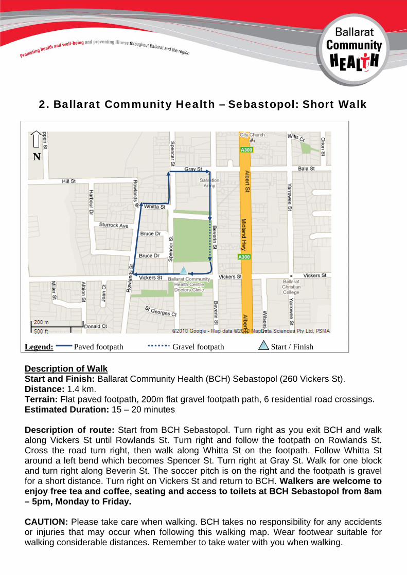
2. Ballarat Community Health – Sebastopol: Short Walk
N Legend: Paved footpath Gravel footpath Start / Finish
Description of Walk Start and Finish: Ballarat Community Health (BCH) Sebastopol (260 Vickers St). Distance: 1.4 km. Terrain: Flat paved footpath, 200m flat gravel footpath path, 6 residential road crossings. Estimated Duration: 15 – 20 minutes Description of route: Start from BCH Sebastopol. Turn right as you exit BCH and walk along Vickers St until Rowlands St. Turn right and follow the footpath on Rowlands St. Cross the road turn right, then walk along Whitta St on the footpath. Follow Whitta St around a left bend which becomes Spencer St. Turn right at Gray St. Walk for one block and turn right along Beverin St. The soccer pitch is on the right and the footpath is gravel for a short distance. Turn right on Vickers St and return to BCH. Walkers are welcome to enjoy free tea and coffee, seating and access to toilets at BCH Sebastopol from 8am – 5pm, Monday to Friday. CAUTION: Please take care when walking. BCH takes no responsibility for any accidents or injuries that may occur when following this walking map. Wear footwear suitable for walking considerable distances. Remember to take water with you when walking.
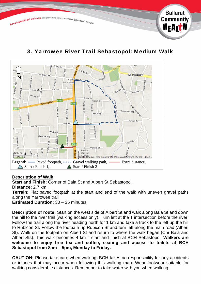
3. Yarrowee River Trail Sebastopol: Medium Walk
N Legend: Paved footpath, Gravel walking path, Extra distance, Start / Finish 1, Start / Finish 2 Description of Walk Start and Finish: Corner of Bala St and Albert St Sebastopol. Distance: 2.7 km. Terrain: Flat paved footpath at the start and end of the walk with uneven gravel paths along the Yarrowee trail Estimated Duration: 30 – 35 minutes Description of route: Start on the west side of Albert St and walk along Bala St and down the hill to the river trail (walking access only). Turn left at the T intersection before the river. Follow the trail along the river heading north for 1 km and take a track to the left up the hill to Rubicon St. Follow the footpath up Rubicon St and turn left along the main road (Albert St). Walk on the footpath on Albert St and return to where the walk began (Cnr Bala and Albert Sts). This walk becomes 4 km if start and finish at BCH Sebastopol. Walkers are welcome to enjoy free tea and coffee, seating and access to toilets at BCH Sebastopol from 8am – 5pm, Monday to Friday. CAUTION: Please take care when walking. BCH takes no responsibility for any accidents or injuries that may occur when following this walking map. Wear footwear suitable for walking considerable distances. Remember to take water with you when walking.
4. Yarrowee River Trail Sebastopol: Long Walk
N Legend: Paved footpath, Gravel walking path, Start / Finish Toilet at Library (Closed Friday, Sunday)
Description of Walk Start and Finish: Corner of Bridge St (Mt. Clear/Sebas Rd) and Albert St, Sebastopol. Distance: 4.8 km Terrain: Relatively even gravel paths, steep up and down hill paved footpath, flat paved footpath, 2 major road crossings. Estimated Duration: 50 – 60 minutes Description of route: Starting the corner of Bridge and Albert Sts, walk along the right-hand side of Bridge St on the footpath down a hill to the entrance of the Yarrowee trail (alongside a large dam/reservoir). Follow the trail to the end (1.8. km). Turn right and walk up the hill on Docwra St. At Albert St cross the road and walk on the footpath with the traffic, north along Albert St along for 1.7 km, returning to Bridge St. Seating is available regularly along Yarrowee Trail and Albert St (bus stops).
CAUTION: Please take care when walking. BCH takes no responsibility for any accidents or injuries that may occur when following this walking map. Wear footwear suitable for walking considerable distances. Remember to take water with you when walking.
5. Sturt St Ballarat: Medium - Long Walk
N Legend: Paved footpath, Start / Finish, Toilets Albert St & Futures Coffee
House.
Description of Walk Start and finish: Futures Coffee House 626 Sturt St (north side). Distance: 4 km. Seating is available frequently on parkway in the middle of the St. Terrain: Gradual uphill and downhill paved footpath. Walkers can enjoy partial overhead cover from shop front awnings as they complete this walk. Estimated Duration: 45 - 55 minutes
Description of route: This walk starts at Futures Coffee House. Turn left as you exit and walk along Sturt St until it finishes at Grenville St. Cross at Bridge Mall, to the South side of Sturt St (this is 1 km) Walk up the hill on Sturt St on the pedestrian footpath. Follow Sturt St all the way up to Pleasant St (2km), at which point walkers can cross Sturt St and follow the road back down the hill to where the walk was started. The shop fronts provide intervals of coverage from inclement weather.
CAUTION: Please take care when walking. BCH takes no responsibility for any accidents or injuries that may occur when following this walking map. Wear footwear suitable for walking considerable distances. Remember to take water with you when walking.
6. Upper Sturt St and Lake Wendouree: Medium Walk
N Legend: Paved footpath, Gravel walking path, Start / Finish.
Description of Walk Start and finish: Futures Coffee House, 626 Sturt St (north side) Distance: 2.5 km - seating is available along the Lake Wendouree walking path. Terrain: Flat paved footpaths as well as a short section of gravel walking path at Lake Wendouree. Estimated Duration: 25 – 30 minutes Description of route: Start at Futures Coffee House. Turn right as you exit building. Turn right at Drummond St lights and follow Drummond St on the footpath past Ballarat Base Hospital. At Drummond and Webster Sts, turn left along Webster St and follow up to Lake Wendouree (Wendouree Pde). Walkers can cross the road and walk on the walking path that surrounds the lake. At Wendouree Pde and Pleasant St North turn left and walk along Pleasant St North until Sturt St is reached. Turn left along Sturt St and finish the walk at Futures Coffee House.
CAUTION: Please take care when walking. BCH takes no responsibility for any accidents or injuries that may occur when following this walking map. Wear footwear suitable for walking considerable distances. Remember to take water with you when walking.
7. Victoria Park: Short Walk
N Legend: Paved driveway, Gravel footpath, Start / Finish.
Description of Walk Start and finish: Playground equipment, BBQ and seating area and toilet block at the front of Victoria Park. Sturt St is the main road which runs besides the starting point (Opposite Hamilton Avenue). Distance: 1.5 km Terrain: Flat gravel walking path and paved road within Vic Park with little traffic. Estimated Duration: 15 – 20 minutes Description of route: Start by walking east along Vic Track walking path and turn right along the first paved road (Caretakers Drive). Follow until the T-intersection of Caretakers Drive and Elm Avenue. Vic Track is on the far side of Elm Avenue. Cross the road and follow Vic Track to the right in the direction of the playground equipment. Cross Oak Av before returning to the playground equipment and BBQ area.
CAUTION: Please take care when walking. BCH takes no responsibility for any accidents or injuries that may occur when following this walking map. Wear footwear suitable for walking considerable distances. Remember to take water with you when walking.
8. Victoria Park: Medium Walk
N Legend: Paved Driveway, Gravel walking path, Start / finish.
Description of Walk Start and finish: Playground equipment, BBQ and seating area and toilet block at the front of Victoria Park. Sturt St is the main road which runs besides the starting point. Distance: 2.8 km Terrain: Flat gravel walking path at the start of the walk followed by paved road within Vic Park with little traffic for the remainder of the walk. Estimated Duration: 35 - 45 minutes
Description of route: Start at Vic Track walking path, heading east, and parallel to Sturt St. Remaining on Vic Track, cross Oak Avenue and follow until Poplar Avenue and turn right. Follow Poplar Av as it crosses Plane Avenue. Poplar Avenue becomes Elm Avenue after it intersects with Cedar Avenue (1.6 km). Follow Elm Avenue past Military Drive and Caretakers Drive and continue until the play equipment and BBQ area are clearly visible. Return to the starting point.
CAUTION: Please take care when walking. BCH takes no responsibility for any accidents or injuries that may occur when following this walking map. Wear footwear suitable for walking considerable distances. Remember to take water with you when walking.
9. Yarrowee River Trails Network – Ballarat East: Short Walk
N Legend: Gravel walking path, Paved residential St, Start / Finish Seating available
Description of Walk Start and finish: Callow St (off Main Rd) just after it intersects with Larter St. The trails are sign posted. No toilets available. Distance: 2.1 km Terrain: Flat gravel walking path which slopes gradually up hill at the beginning of the walk and down hill at the end of the walk. In the middle is a paved road without footpath for 500 metres along Joseph St (light traffic). Estimated Duration: 25 – 30 minutes Description of route: Follow the Warrenheip Gully Trail at the beginning. At Joseph St (760 metres along the trail) turn right and follow the road for 500 metres until the Pennyweight Gully Trail is reached, at the corner of Wilson and Joseph Sts, and turn right and follow Pennyweight Gully Trail to the start of the walk. CAUTION: Please take care when walking. BCH takes no responsibility for any accidents or injuries that may occur when following this walking map. Wear footwear suitable for walking considerable distances. Remember to take water with you when walking.
10. Yarrowee River Trails Network – Ballarat East: Medium Walk
N Legend: Gravel walking path, Paved footpath, Start / finish. Seating available
Description of Walk Start and finish: Callow St (off Main Rd) just after it intersects with Larter St. The trails are sign posted. No toilets available. Distance: 3.3 km Terrain: Flat gravel walking path which slopes gradually up hill at the beginning of the walk and down hill at the end of the walk. The middle of the walk is characterised by a paved footpath along Kline St for 570 metres. Estimated Duration: 35-40 minutes Description of route: Follow the Warrenheip Gully Trail for 1.3 km and at Kline St turn right and follow the footpath beside the road for half a kilometre. At Wilson St turn right and follow Wilson St for two blocks until this road links up with the Pennyweight Gully trail and follow the trail to the start of the walk. CAUTION: Please take care when walking. BCH takes no responsibility for any accidents or injuries that may occur when following this walking map. Wear footwear suitable for walking considerable distances. Remember to take water with you when walking.
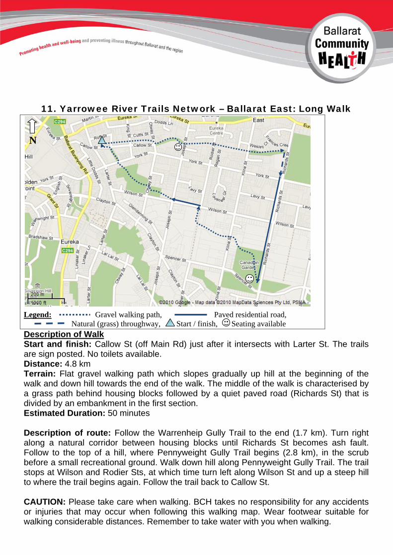
11. Yarrowee River Trails Network – Ballarat East: Long Walk
N Legend: Gravel walking path, Paved residential road, Natural (grass) throughway, Start / finish, Seating available Description of Walk Start and finish: Callow St (off Main Rd) just after it intersects with Larter St. The trails are sign posted. No toilets available. Distance: 4.8 km Terrain: Flat gravel walking path which slopes gradually up hill at the beginning of the walk and down hill towards the end of the walk. The middle of the walk is characterised by a grass path behind housing blocks followed by a quiet paved road (Richards St) that is divided by an embankment in the first section. Estimated Duration: 50 minutes Description of route: Follow the Warrenheip Gully Trail to the end (1.7 km). Turn right along a natural corridor between housing blocks until Richards St becomes ash fault. Follow to the top of a hill, where Pennyweight Gully Trail begins (2.8 km), in the scrub before a small recreational ground. Walk down hill along Pennyweight Gully Trail. The trail stops at Wilson and Rodier Sts, at which time turn left along Wilson St and up a steep hill to where the trail begins again. Follow the trail back to Callow St. CAUTION: Please take care when walking. BCH takes no responsibility for any accidents or injuries that may occur when following this walking map. Wear footwear suitable for walking considerable distances. Remember to take water with you when walking.