32
Wap Creek Park Management Plan GF May 2013
Wap Creek Park Management Plan
GF
May 2013

This page left blank intentionally

Wap Creek Park
Management Plan
Approved by:
______________________________ May 23, 2013______ Tom Bell Date Regional Director, Kootenay Okanagan BC Parks
______________________________ May 17, 2013______ Brian Bawtinheimer Date Executive Director, Parks Planning and Management Branch BC Parks
Wap Creek Park Management Plan
i
Table of Contents 1.0 Introduction ......................................................................................................... 1
1.1 Purpose 1
1.2 Planning Context/Area 1
1.3 Legislative Framework 4
1.4 Management Commitments 4
1.5 Relationship with First Nations 6
1.6 Community Interest 6
1.7 Planning Process 7
2.0 Values and Roles of the Park ................................................................................ 8
2.1 Significance in the Protected Areas System 8
2.2 Wildlife Species, Ecosystems and Habitats 9
Values ...................................................................................................................... 9
Role........................................................................................................................ 11
2.3 Cultural Heritage 11
Values .................................................................................................................... 11
Role........................................................................................................................ 11
2.4 Recreation 12
Values .................................................................................................................... 12
Role........................................................................................................................ 12
2.5 Other Attributes 12
3.0 Management Direction ...................................................................................... 14
3.1 Park Vision 14
3.2 Overall Management Goals 14
3.3 Management Objectives, Opportunities/Stressors and Strategies 15
3.4 Zoning 18
Nature Recreation Zone ........................................................................................ 18
Cultural Zone ......................................................................................................... 18
4.0 Plan Implementation ......................................................................................... 20
4.1 Implementation Period 20
4.2 High Priority Strategies 20
4.3 Management Plan Review 20
4.4 Performance Measures 21
Appendix 1: Species at Risk ....................................................................................... 22
Appendix 2: Appropriate Uses Table ......................................................................... 25
Appendix 3: Park Specific Stressors to Maintaining Ecological Integrity ..................... 28
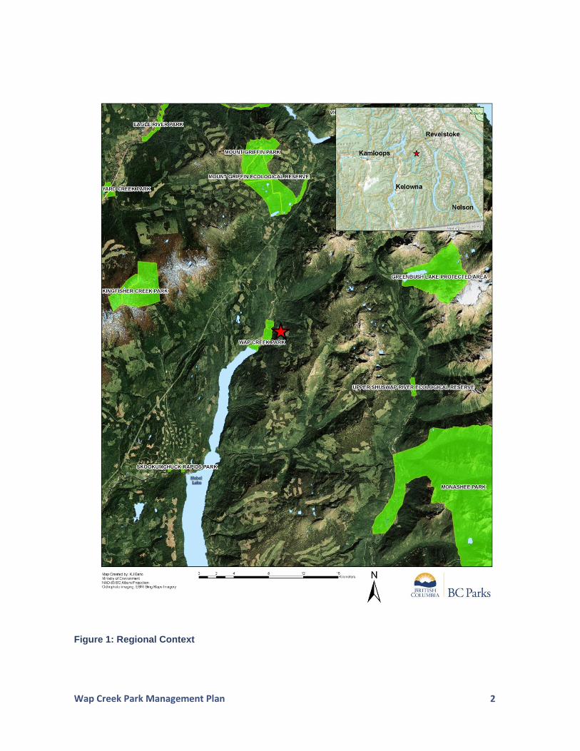
List of Figures: Figure 1: Regional Context ...................................................................................................... 2
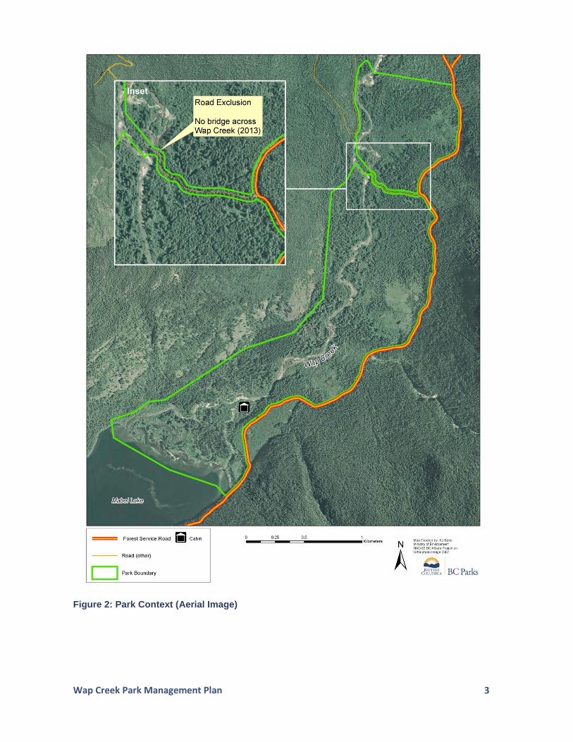
Figure 2: Park Context (Aerial Image) ..................................................................................... 3
Figure 3: GAR Order/Range Tenure ........................................................................................ 5
Figure 4: Park Zoning ............................................................................................................ 19

Wap Creek Park Management Plan
1
1.0 Introduction
1.1 Purpose
This management plan:
establishes long-term strategic direction for Wap Creek Park;
sets out a vision for the future state of the park;
addresses current issues affecting that long-term vision;
determines the appropriate levels of use and development; and
guides day-to-day park management through established management strategies.
1.2 Planning Context/Area
The 328 hectare park is located approximately 40 kilometres southwest of Revelstoke at the headwaters of Mabel Lake within the North Okanagan Regional District. Nearby parks and protected areas include Mabel Lake Park (30 kilometres to the south), Kingfisher Creek Park (10 kilometres to the northeast) and Mount Griffin Park (12 kilometres to the north). The park is situated within the Shuswap River Highland Ecosection. Wap Creek Park was identified for protection as a Goal 21 site in the 2001 Okanagan-Shuswap Land and Resource Management Plan. The site was recommended for protection because of its importance in maintaining wetland and riparian features at the head of Mabel Lake. Much of the land area around the park has been affected by industrial logging as part of the Okanagan Timber Supply Area. The park is bisected by a non-status road (which currently does not span the creek). The excluded road (Figure 2) creates a north/south division in the park landscape to allow for future industrial logging access to the northwest of the park. The name Wap Creek is a diminutive of ‘Shuswap’ which was used by early settlers. The creek was referred to as Frog Creek prior to the 1930s, but was formally named as Wap Creek in 1932. With respect to First Nations, the park is situated within the consultative areas of the Neskonlith Indian Band, Little Shuswap Indian Band, Splatsin, Okanagan Indian Band, Lower Similkameen Indian Band and the Okanagan Nation Alliance. Primary access to the park is from the Mabel Lake Forest Service Road.
1 Goal 2 sites are those identified and recommended for protection in the Okanagan-Shuswap Land and Resource Management Plan as containing special natural, cultural heritage and recreational features.
Wap Creek Park Management Plan
2
Figure 1: Regional Context
Wap Creek Park Management Plan
3
Figure 2: Park Context (Aerial Image)

Wap Creek Park Management Plan
4
1.3 Legislative Framework
Wap Creek Park was established as a Class A park on June 27, 2008. The park is named and described in Schedule D of the Protected Areas of British Columbia Act.
Class A parks are dedicated to the preservation of their natural environments for the inspiration, use and enjoyment of the public.
1.4 Management Commitments
As identified in the Okanagan-Shuswap Land and Resource Management Plan2, general management direction for all new protected areas within the plan area is as follows:
Local level development of individual management plans must be consistent with objectives and strategies outlined in the Okanagan-Shuswap Land and Resource Management Plan.
All parties with a key interest or stake in the area are encouraged to be involved in the management plan.
Protected areas are dedicated to present and future generations for a spectrum of compatible conservation and recreation uses.
Protected areas are places of education, appreciation and inspiration.
Protected area land and resources may not be sold.
No resource extraction or development is permitted.
No mining, logging, hydro electric dams or oil and gas development will occur within protected areas.
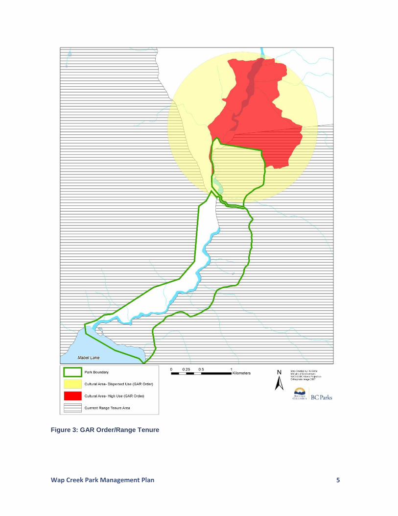
A proposed industrial road that travelled through the original proposed park land base was identified during the land use planning process. A provision of the land use plan was to allow for a boundary modification of the park in the future. However, prior to park establishment, a road layout was reached at the land use planning table and the land area required for road dedication was not included in the park at the time of designation; therefore, no future boundary adjustment accommodating an industrial road is required. A Government Actions Regulation (designated under the Forest and Range Practices Act) for First Nations’ traditional use overlaps in the northern section of the park. The management of the park in this area is to remain consistent with the purposes of the cultural use zones as identified (i.e., no livestock grazing).
2 A full version of the Okanagan-Shuswap Land and Resource Management Plan can be viewed at http://archive.ilmb.gov.bc.ca/slrp/lrmp/kamloops/okanagan/plan/files/oslrmpfull.pdf .
Wap Creek Park Management Plan
5
Figure 3: GAR Order/Range Tenure
Wap Creek Park Management Plan
6
1.5 Relationship with First Nations
The park lies within the consultative areas of the Okanagan Nation Alliance, Okanagan Indian Band, the Lower Similkameen Indian Band, Splatsin, Neskonolith Indian Band and the Little Shuswap Indian Band (the three latter bands are also known collectively as the Secwepemc). The Splatsin have outlined an interest in collaborative management of the park and supported the establishment of the park. Prior to establishment, the Splatsin voiced concerns over the size and configuration of the park, stating that a larger boundary would have better protected their aboriginal interests. There is also interest from both the Splatsin and the Neskonlith Indian Band in renaming the park to honour Dr. Mary Thomas, a respected elder of the Secwepemc Nation who passed away in 2007.
The Okanagan Nation Alliance (which includes the Lower Similkameen Indian Band and the Okanagan Indian Band), although recognizing the importance of the site’s conservation and cultural heritage values, cite that they do not support parks and protected areas that were established as an outcome of the Okanagan-Shuswap Land and Resource Management Plan. It is hoped that the Okanagan Nation Alliance’s interests can be reflected in the park’s management objectives and strategies as outlined in this management plan.
1.6 Community Interest
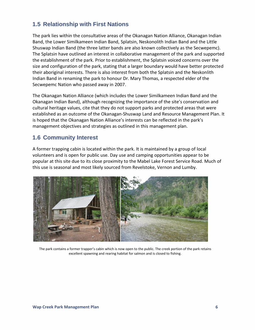
A former trapping cabin is located within the park. It is maintained by a group of local volunteers and is open for public use. Day use and camping opportunities appear to be popular at this site due to its close proximity to the Mabel Lake Forest Service Road. Much of this use is seasonal and most likely sourced from Revelstoke, Vernon and Lumby.
The park contains a former trapper’s cabin which is now open to the public. The creek portion of the park retains excellent spawning and rearing habitat for salmon and is closed to fishing.
Wap Creek Park Management Plan
7
1.7 Planning Process
The management plan for Wap Creek Park utilized the recommendations of the Okanagan-Shuswap Land and Resource Management Plan (2001) as a main source for management direction. A draft plan was prepared in early 2011, which was available for public, stakeholder, First Nations and government agency review. Discussions with the membership of the Secwepmec Nation and the Splatsin provided further clarification on the important role the park and adjacent landscape have in maintaining the cultural heritage significance to First Nations. Subsequent revisions of the draft management plan were based on input and direction from various entities.
Wap Creek Park Management Plan
8
2.0 Values and Roles of the Park
2.1 Significance in the Protected Areas System
Wap Creek Park is significant in the parks and protected areas system because it:
Protects an increasingly rare old growth black cottonwood ecosystem. The BC Conservation Data Centre has ranked the cottonwood ecosystems of the southern interior among the rarest plant communities in the province.
Protects a valley bottom covering terrestrial and aquatic ecosystems in a protected areas system in which valley bottom landscapes are under-represented.
The park contains habitat that supports the high probability of supporting the occurrence of at least 34 species at risk.
Protects two ‘at risk’ ecological communities, which exist within the park (Sitka willow - Pacific willow / skunk cabbage and western redcedar - western hemlock / common horsetail).
Protects an under-represented Biogeoclimatic (BGC) variant - ICH mw2 (Interior Cedar Hemlock moist wet) - in the Shuswap River Highlands Ecosection. Only 1.2% of this BGC variant is protected within this ecosection. Province wide, only 9.5% of the ICHmw2 is protected, with the park contributing 0.06%.
Assists in protecting essential habitat for Grizzly Bears (a blue-listed species) within a larger Grizzly Bear Wildlife Habitat Area in the Central Monashee population unit.
Is encompassed by a larger approved ungulate winter range for Moose.3
Enhances protection within an approved Fisheries Sensitive Watershed4 covering Wap Creek.
Provides intact salmon spawning and rearing habitat for three species of salmon (Coho, Chinook, and Pink) as part of the Shuswap River drainage. Coho in this region of the province are genetically distinct and an evolutionary significant unit with very low population numbers. Non-anadromous fish such as Bull Trout (a blue-listed species) and Kokanee are also present in the Wap Creek system.
Contributes to the protection of a provincially significant salmonid fishery (i.e., there is currently a fishing closure from the outlet at Mabel Lake for approximately 25 kilometres north towards Revelstoke - this includes the creek area within the park).
Contains remnant stands of old-growth forest and riparian values in an area which has undergone extensive logging. As such, the park acts as a refuge for many terrestrial and aquatic species.
Provides for exceptional hiking and wildlife viewing opportunities in a remote and scenic backcountry setting.
3 Ungulate winter ranges are sites that contain high value forage and contain habitat that is necessary to meet the winter habitat requirements of an ungulate species.
4 A Fisheries Sensitive Watershed is created through legislation, specifically the Forest and Range Practices Act. The designation identifies those watersheds that have high ecological and fisheries values, both in upland components as well as in stream values. The aim is to draw greater attention to the responsible industrial and resource uses in these watersheds so as not to negatively impact the significant conservation values contained within them.

Wap Creek Park Management Plan
9
Protects an area with a high diversity of natural resources essential for food, social and ceremonial harvesting and cultural practices of First Nations.
2.2 Wildlife Species, Ecosystems and Habitats
Values
Ecosystem Representation
Wap Creek Park (328 hectares) lies predominantly within the Interior Cedar Hemlock moist wet BGC variant (ICH mw2) with 314 hectares in the ICHmw2 and 14 hectares classified as foreshore. The park contains upland forest containing mixed age classes of western redcedar, hemlock and Douglas-fir. The riparian areas of the park are lined with thick vegetation predominated by impressive stands of large diameter black cottonwood. Such old growth stands of black cottonwood are becoming increasingly rare in the province.
Fish and Wildlife Habitat
Owing to its unique riparian values, Wap Creek Park contains important habitat for many species of waterfowl and shorebirds, upland bird species, and ungulates such as deer (Whitetail/Mule Deer) and Moose, as well as smaller mammals including American Marten, North American Porcupine and a variety of bat species. The old growth forest characteristics (such as recessed cavities that occur in black cottonwood and western redcedar) provide shelter for many cavity nesting species such as owls and woodpeckers.
Grizzly Bears are known to frequent the Monashee Mountains. This rugged mountain range contains the necessary foraging characteristics for Grizzly Bears (i.e., avalanche paths, sub-alpine and alpine meadows). Although the park is largely situated in the valley bottom, grizzlies that come down from the higher ranges are using the park seasonally as part of their migration cycle and frequent the park specifically during the large salmon spawning runs that occur primarily in the fall of each year. It is not uncommon for Coho, Chinook, and Pink Salmon to utilize the side channels of the creek for spawning and rearing. The creek is closed to fishing to help protect the high value salmon habitat.
The land area around the park has been heavily affected by industrial logging and associated road building. This has created, to a large extent, an important refuge characteristic to the park, a feature in which a variety of species have benefited.
Species and Ecological Communities of Conservation Concern
Although formal species and habitat inventories within the park have not yet been conducted, spatial data5 indicate that the park supports habitat for several red and blue-listed species and ecological communities. See Appendix 1 for a list of all known or suspected species at risk.
5 Source: Hectares BC.
Wap Creek Park Management Plan
10
Conservation Framework Context
The Conservation Framework is a provincial government initiative designed to allow effective prioritization of provincially and globally significant species and ecological communities based upon standardized rankings within a set of identified goals. A species’ or ecological community’s priority relates to the goal in which the species/community ranks the highest. Recommended tasks or tools are assigned to each species/community, ranging from species inventories to ecosystem restoration and/or stewardship to legislative tools.6 Appendix 1 contains the relevant Conservation Framework prioritization number (if applicable) for species at risk found within the park or for species which have the potential to occur in the park.
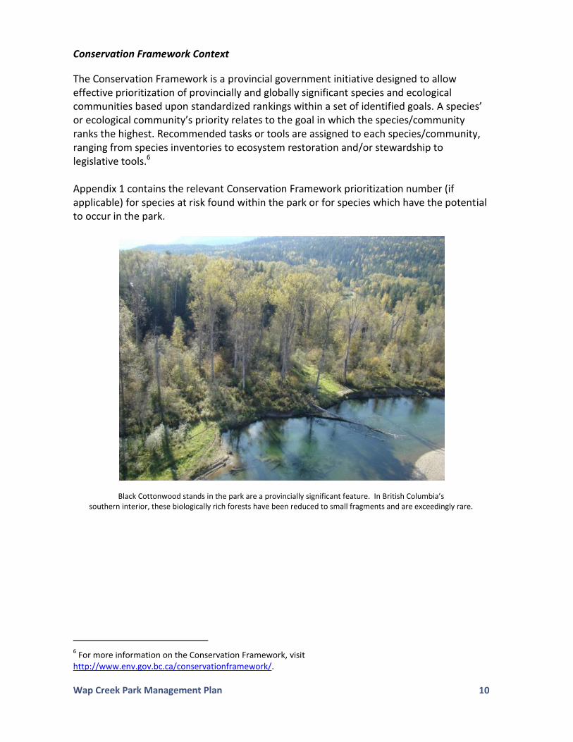
Black Cottonwood stands in the park are a provincially significant feature. In British Columbia’s southern interior, these biologically rich forests have been reduced to small fragments and are exceedingly rare.
6 For more information on the Conservation Framework, visit
http://www.env.gov.bc.ca/conservationframework/.
Wap Creek Park Management Plan
11
Role
The conservation role of Wap Creek Park is to protect a valley bottom old growth forest, riparian, stream and foreshore area that retains significant habitat values associated with both a freshwater and upland forested ecosystem. Wap Creek also contains critical spawning habitat for Pacific run salmon as well as habitat for Kokanee and Bull Trout (a blue-listed fish species). Despite the fragmented nature of the land area surrounding the park as a result of industrial activity (primarily logging), the park continues to provide essential habitat for Grizzly Bear as well as a host of other flora and fauna species at risk.
2.3 Cultural Heritage
Values
The Okanagan and Secwepemc First Nations were known to frequent the area in pre-colonial times for hunting, fishing and gathering. Today, the area retains important values for First Nations. Dr. Mary Thomas, a highly respected Neskonlith elder of the Secwepemc Nation and advocate for the preservation of Secwepemc language and culture, frequently visited the area of Wap Creek. Because of her long standing interest in the area, the ministry responsible for forestry, through the Government Actions Regulation, established a 221 hectare ‘cultural resource feature’ located immediately northeast of the park that places limitations on resource activity (logging, road building and cattle grazing) in an effort to retain food, social and ceremonial values on the landscape for the Secwecpemc (see Figure 3). The cultural resource feature also complements the conservation values of the park by providing a substantial ‘resource activity free’ buffer to the northeast. Because of its retention of intact old-growth forest, riparian and fishery values, the park’s landscape continues to support traditional activities of First Nations. There are no registered archaeological sites within the park; however, cache pit7 depressions have been located close to the park boundary.
Role
Although largely un-researched, Wap Creek Park is known to protect important cultural heritage values within the Shuswap River Highlands. Its valley bottom location at the head of Mabel Lake has served as a backdrop for thousands of years of First Nations use and habitation. Nearby protection measures, such as the cultural resource feature (in honour of Dr. Mary Thomas), are a testament to the important cultural values within the immediate area. The park serves as an integral piece in an assemblage of cultural features that facilitates continued First Nations uses and practices.
7 Cache pits are circular excavations usually less than 3 m in diameter which functioned as storage cellars.

Wap Creek Park Management Plan
12
2.4 Recreation
Values
Recreational activities in Wap Creek Park include boating (specifically access off the beach areas on Mabel Lake), hiking (although limited because of dense creek-side vegetation), camping, wildlife viewing, nature appreciation and hunting. Fishing is not permitted on Wap Creek (due to the sensitivity of spawning and rearing habitat for salmonid species); however, on the Mabel Lake portion of the park, fishing is permitted. Approach to the park via Mabel Lake can present challenges because of unstable ground due to fluctuating water levels at the beach frontage and few moorage opportunities.
The former trapper’s cabin, which is now available for public use, is accessed via a short five minute walk from the Mabel Lake Forest Service Road. The cabin is situated immediately adjacent to Wap Creek and is an ideal setting for day use or rustic camping opportunities.
Role
The recreation role of Wap Creek Park is to provide river access opportunities in the Wap Creek valley, which are currently limited. The park provides shoreline creek access for hikers and boaters (specifically non-motorized) as well as an opportunity for motorized boat access to the head of Mabel Lake.8 Day use exploration of the creek frontage and overnight use at the former trapper’s cabin add diversity to the park’s recreational characteristics.
The south end of Wap Creek Park viewed from Mabel Lake.
2.5 Other Attributes
Two forest range tenures (RAN 077016 and 0776011) for the purposes of cattle grazing overlap the park. RAN 0776011 overlaps areas north of the Wap Creek, but the tenure boundary starts approximately halfway up towards the northern park boundary (i.e., it does not cover the entire area north of the creek within the park) (see Figure 3). RAN 077016
8 The beach area is constrained by limited flat ground and heavy vegetation/muddy conditions due to the fluctuating high water mark making camping/extended use impractical.
Wap Creek Park Management Plan
13
covers the entire area south of Wap Creek toward the southern boundary of the park. The Government Actions Regulation Order for the Cultural Heritage Resource Feature does not allow for cattle grazing within what is referred to as the ‘dispersed use zone’ of the Government Actions Regulation Order. This applies to the northern quarter of the park (see Figure 3).
Two trapping territories are located within the park. TR0824T058 resides north of Wap Creek, whereas TR0824T051 is situated south of the creek. The guide outfitter territory for Management Unit 8-24 is currently vacant, and it is not anticipated to be allocated in the foreseeable future.
There are no facilities associated with current commercial activities in the park.

Wap Creek Park Management Plan
14
3.0 Management Direction
3.1 Park Vision
This park vision describes the future state and management regime that is desired for Wap Creek Park over the next 25 to 50 years. The park vision provides long-term direction for park managers, while aiding them in making decisions regarding current issues. It is based on prevailing environmental and socio-economic attitudes concerning protected areas. It is, however, dynamic and conceptual and therefore allows for change due to evolving ideas regarding conservation and recreation and evolving ecosystems due to climate changes. Despite its small size, Wap Creek Park continues to protect an intact old growth forest, creek and lakeshore ecosystem within a larger landscape historically modified by industrial logging. The unique valley bottom foreshore and vegetation characteristics of the park provide important refuge habitat for a variety of fish and wildlife species, many of which have been ‘at risk’ in the province. The park also acts as an important source of species colonization into the regenerating forests outside the park.
Recreationalists, such as hikers and boaters, continue to enjoy the old growth cottonwood-lined shores of Wap Creek and the secluded beach area located within the park at the head of Mabel Lake.
The importance of Wap Creek Park to First Nations has been researched and the park continues to provide an important association to food, social and ceremonial harvesting activities of First Nations as well as preserving other intrinsic spiritual and cultural values. The park also serves as an important linkage to the nearby cultural resource area designated by the BC Forest Service in honour of Dr. Mary Thomas, a respected elder of the Secwepemc Nation.
3.2 Overall Management Goals
The overall management goal of Wap Creek Park is the protection of valley bottom riparian, lakeshore and old growth forest ecosystems. In addition, the management goals emphasize the protection of significant cultural values and providing a high quality visitor experience directed at nature appreciation and outdoor activities such as hiking, boating, and wildlife viewing.
Wap Creek Park Management Plan
15
3.3 Management Objectives, Opportunities/Stressors and Strategies
Objective
Management Opportunities/Stressors
Strategies
To minimize the future impact that forest harvesting activities and related access on adjacent lands have on park values (e.g., minimize edge effects).
Adjacent forest harvesting and associated road access have created an island and refuge characteristic to the park.
Work with the Crown agencies responsible for forest tenuring and operations and with forest licensees to minimize the effects of forest harvesting activities on adjacent lands (e.g., monitor/mitigate windthrow events along park boundary).
Review forest stewardship plans when appropriate.
Work towards having forest tenured roads leading to the park periphery deactivated once harvesting and post-harvesting requirements are completed.
To minimize cattle grazing impacts within the park, specifically in areas of high conservation values (e.g., black cottonwood)
Range use (cattle grazing) can impact sensitive riparian areas and endangered plants communities such as the black cottonwood ecosystem.
Work with range tenure holders and Provincial agencies responsible for range to ensure range use plan(s) incorporate park values into range management.
Ensure Government Actions Regulation Order area - Cultural Heritage Resource Feature (for no cattle grazing) is monitored for compliance.
Discourage cattle use (utilizing fencing, removal of salt blocks and still wells) in high value habitat areas such as creeks, riparian areas and the black cottonwood ecosystem where fish spawning is occurring and near water sources for park visitor consumption.
To protect species and ecological communities from disturbance (human or domestic animals).
Lack of species and ecological community inventories in the park limit the ability of discerning where sensitive ecological sites are and avoiding impacts.
Conduct ground investigations and spatial analysis using Terrestrial Ecosystem Mapping (when it becomes available) to identify species and ecological communities of conservation concern.
Avoid impact on species and ecological communities of conservation concern with specific emphasis on black cottonwood and riparian areas in the development of proposed facilities and trails.

Wap Creek Park Management Plan
16
Objective Management Opportunities/Stressors
Strategies
Inform visitors of the general characteristics of species and ecological communities of conservation concern to avoid impacts.
Ensure compliance with the ‘no fishing’ regulation that applies to Wap Creek.
To ensure park lands are not further isolated from the larger ecosystem in which they are embedded.
Landscape connectivity in the area is highly fragmented due to resource activity, but the park location creates an important landmark for species in/out migration.
Identify important linkages between ecosystems within the park and areas outside the park (e.g., upstream migration of fish and wildlife, valley crossing by mammals using historic wildlife corridors).
To minimize the carbon footprint from park operations.
Lack of identification of climate change impacts and strategic planning over the short and long term has the ability to affect park values (both internally and externally).
Minimize greenhouse gas emissions from
park management actions (e.g., using green building products, recycled content in construction material, promote vehicle pooling for visitation to nearby parks).
Use “green” technology for designing and developing new facilities where feasible.
Factor future climate change into management decisions.
Climate change has the ability to alter park values considerably if not adequately addressed/mitigated.
Summarize/evaluate potential effects of
climate change on park weather, hydrology, vegetation, fish and wildlife based on existing information.
Use the above summary to determine appropriate actions for managing climate change impacts.
Encourage research/monitoring of the effects of climate change on park values and ecosystem functions.

Wap Creek Park Management Plan
17
Objective Management Opportunities/Stressors
Strategies
To protect cultural heritage values existing within the park and to work collaboratively with First Nations in management.
Traditional management and cultural practices have occurred and continue to occur in the Wap Creek valley as the area is of high importance to First Nations.
Perform historical and ethnographic research (e.g., archaeological investigation/assessments) if developments are proposed or funding opportunities arise.
Identify threats to cultural heritage values and implement appropriate protective measures for sensitive sites.
Work with local First Nations to identify cultural heritage or traditional use interpretation opportunities within the park.
Consider undertaking management and interpretation partnerships with First Nations.
Engage First Nations in operational and management issues relating to the park.
Support local First Nations in the preparation of a justification/rationale for renaming the park in honour of Dr. Mary Thomas, and submitting this proposal for consideration by the Minister.
To provide a high quality recreational experience while ensuring activities (existing or proposed) do not negatively impact conservation or cultural values in the park.
No formalized Crown land use arrangement with cabin stewards has led to ad hoc maintenance and upkeep. Dispersed use (e.g., indiscriminate camping) has led to degradation of areas within the park.
Investigate stewardship agreement with individuals/groups responsible for maintaining the former trapper’s cabin.
Provide interpretive (e.g., salmon spawning habitat, species at risk habitat, cultural heritage) and informational signage (e.g., no-trace camping) for park users.
Ensure visitors are aware (through signage and ranger patrols) that fishing on Wap Creek is not permitted and that fishing is only permitted on the Mabel Lake portion of the park.

Wap Creek Park Management Plan
18
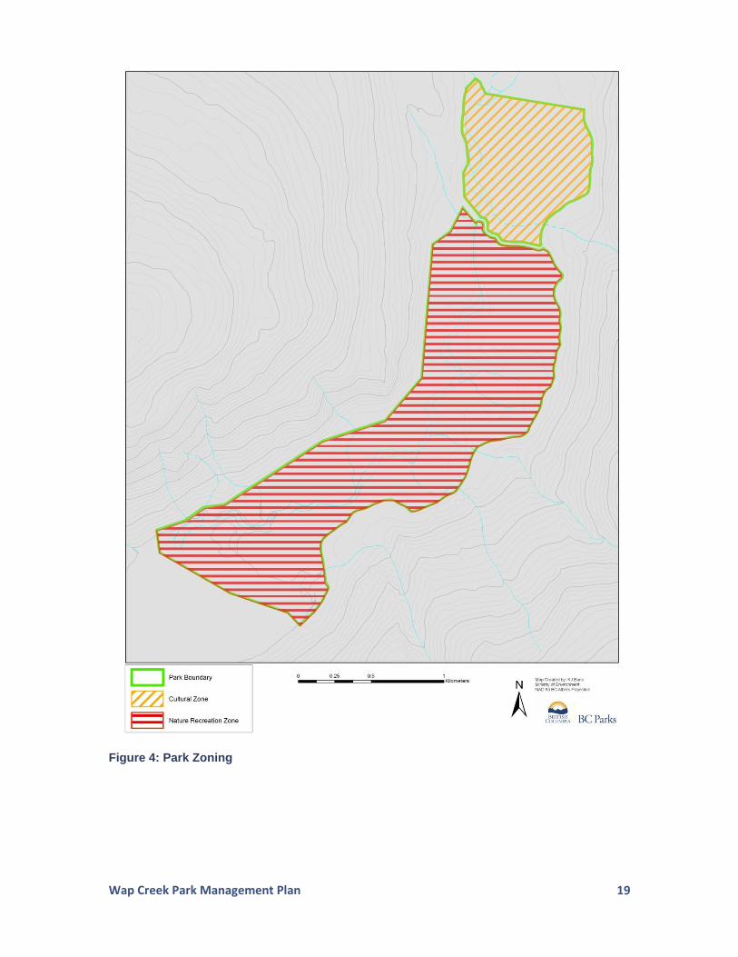
3.4 Zoning
Zoning assists in the planning and management of protected areas. In general terms, zoning divides an area into logical units to apply consistent management objectives. The zones reflect the intended land use, the degree of human use desired, and the level of management and development allowed in specified areas.
There are six types of zones in the BC Parks Zoning Framework. At one end of the spectrum, the Intensive Recreation Zone indicates a portion of a protected area that is appropriate for high levels of recreation and facility development. At the opposite end, the Wilderness Conservation Zone indicates an area within a protected area that receives the highest level of resource protection and minimal human presence. In addition, there are four other zones providing a range of conservation and use priorities – Nature Recreation Zone, Special Feature Zone, Wilderness Recreation Zone and Cultural Zone. Wap Creek Park is divided into two management zones (Figure 4).
Nature Recreation Zone
Description
The Nature Recreation Zone encompasses 258 hectares of the park. The zone is situated south of the resource road access (which is excluded from the park) which runs in a north/south orientation across the park (Figure 2). The zone includes the foreshore component of the park.
Objective and Management Intent
The Nature Recreation Zone reflects the visitor use that emanates from boating access from Mabel Lake as well as vehicle traffic along the Mabel Lake Forest Service Road. Because of limited access to the park, the most popular area of convergence is the former trapper’s cabin along the shores of the creek. The Nature Recreation Zone is the park’s desired area of recreation use and assists in isolating the more sensitive cultural zone that is situated to the northeast.
Cultural Zone
Description
The Cultural Zone encompasses 70 hectares of the park. The zone is located to the north of the resource road exclusion that bisects the park.
Objective and Management Intent
This zone incorporates the overlap area of the adjacent Wap Creek Cultural Heritage Resource Feature (Dispersed Use Zone) that was created through a Government Actions Regulation Order to assist in the protection of the high value cultural and spiritual activity in the immediate area. Past and contemporary First Nations traditional uses occur in this zone, including hunting, camping, fishing, food, and medicinal plant collection. This zone also holds a spiritual significance associated with healing and well being to First Nations.
Wap Creek Park Management Plan
19
Figure 4: Park Zoning
Wap Creek Park Management Plan
20
4.0 Plan Implementation
4.1 Implementation Period
Implementing the management strategies in this management plan will be subject to available funding and staff resources. Where possible, partnerships will be developed with First Nations, stakeholders and local communities to achieve specific strategies.
4.2 High Priority Strategies
The following strategies were identified as high priorities for implementation for Wap Creek Park.
1. Work with the Crown agencies responsible for forest tenuring and operations and with forest licensees to minimize the effects of forest harvesting activities on adjacent lands.
2. Perform historical and ethnographic research (e.g., aboriginal use study, archaeological assessments) and cultural heritage field inventories if developments are proposed or funding opportunities arise.
3. Engage First Nations in operational and management issues relating to the park and provide support for the preparation of a justification/rationale for renaming the park in honour of Dr. Mary Thomas, and submitting this proposal for consideration by the Minister.
4. Investigate stewardship agreement with individuals/groups responsible for
maintaining the former trapper’s cabin.
5. Conduct ground investigations and spatial analysis using Terrestrial Ecosystem Mapping (when it becomes available) to identify species and ecological communities of conservation concern.
6. Provide interpretive (e.g., salmon spawning habitat, species at risk habitat,
cultural heritage) and informational signage (e.g., no-trace camping) for park users.
4.3 Management Plan Review
A management plan review is an internal process to identify if any changes are needed to the management plan. A management plan review looks for any necessary updates to the management plan that: are required to keep management direction current and relevant; correct the intent of a policy statement; address some error or omission; or address a new proposal.
Wap Creek Park Management Plan
21
In order to ensure management plans remain contemporary and relevant, it is important that the management plan is reviewed on a regular basis (i.e., a 5 year time period). Management plan reviews should occur within a timeframe that reflects the complexities of the management issues in a protected area as well as the funding and resources needed to conduct the review. A review of the management plan content should also be triggered by changing circumstances (e.g., circumstances such as a major natural disturbance event or environmental change such as mountain pine beetle spread or wildfire) and not by a specific time period alone.
4.4 Performance Measures
A list of performance measures has been identified to assist in determining if overall goals (see Section 3.2) are being met.
Wap Creek Park: Management Goals and Performance Measures
Goal: Protection and Maintenance of Ecological Integrity and Natural Environments
Performance Measures
▪ Established baseline inventory on priority plant and animal species (with particular focus on species at risk).
▪ Minimized cattle impacts in the park and continued monitoring of no cattle use in the Cultural Zone/Government Actions Regulation Order Cultural Heritage Resource Feature - Dispersed Use Zone.
▪ Discussions on connectivity with adjacent land managers/licensees have occurred.
▪ Windthrow and invasive plant monitoring along park boundary (as a result of adjacent forest harvesting activities) have been implemented.
▪ No new road encroachment or motorized access has occurred into the park.
▪ Centralized camping area has been designated at the former trapper’s cabin site.
▪ Former impacted sites (e.g., indiscriminate camping areas and fire rings near cabin site) have been restored.
Goal: Preservation and Maintenance of Cultural Use Values
Performance Measures
▪ Cultural/archaeological inventories have been undertaken.
▪ First Nations’ cultural resources are protected and sustained.
▪ There is complementary management with the adjacent Cultural Heritage Resource Feature Zone associated with the Government Actions Regulation Order (i.e., no cattle grazing).
▪ First Nations are able to practice their cultural activities (including the harvest of traditional materials for food, social and ceremonial purposes).
Goal: Protection and Maintenance of Recreation Values
Performance Measures
▪ Discussions towards a formalized agreement with volunteer stewards for former trapper’s cabin have been initiated.
▪ Interpretive and informational signage have been placed at key locations.
▪ Park visitors are aware of the sensitive ecosystem being protected within the park, while opportunities to provide low impact recreation opportunities have been maintained throughout the park (e.g., hiking, wildlife viewing, boating, hunting) with angling permitted on Mabel Lake only.

Wap Creek Park Management Plan
22
Appendix 1: Species at Risk
Red and Blue List Context
The Ministry of Environment categorizes ‘species at risk’ utilizing the Red and Blue lists. The following is a brief description of the designations:
Red List:
Includes any ecological community and indigenous species or subspecies that is extirpated, endangered, or threatened in British Columbia. Extirpated elements no longer exist in the wild in British Columbia, but do occur elsewhere. Endangered elements are facing imminent extirpation or extinction. Threatened elements are likely to become endangered if limiting factors are not reversed. Red-listed species and sub-species may be legally designated as, or maybe considered candidates for legal designation as Extirpated, Endangered or Threatened under the Wildlife Act. Not all red-listed taxa will necessarily become formally designated. Placing taxa on these lists flags them as being at risk and requiring investigation.
Blue List:
Includes any ecological community, and indigenous species and subspecies considered to be of special concern (formerly vulnerable) in British Columbia. Elements are of special concern because of characteristics that make them particularly sensitive to human activities or natural events. Blue-listed elements are at risk, but are not Extirpated, Endangered or Threatened.
The Conservation Framework Prioritization Tool Context This tool ranks B.C. species and ecosystems of conservation concern for management action, based on five clearly defined criteria: global and provincial status trends threats stewardship responsibility feasibility of recovery
Each species or ecosystem receives a rank of 1 (highest) through 6 (lowest) under each of the three goals and is managed under the goal in which it receives the highest score.

Wap Creek Park Management Plan
23
Species at Risk in Wap Creek Park
Ecological Communities at Risk
The following ecological community is red listed in the province and has the potential to occur within the park. Conservation Framework prioritization is listed (if applicable):
Sitka willow - Pacific willow / skunk cabbage (Salix sitchensis - Salix lucida ssp. lasiandra / Lysichiton americanus) - Priority 1/Goal 1
The following ecological community is blue listed in the province and has the potential to occur within the park:
western redcedar – western hemlock / common horsetail (Thuja plicata - Tsuga heterophylla / Equisetum arvense) - Priority 2/Goal 1
Flora Species at Risk
Six red-listed plant species may also be present:
yellow widelip orchid (Liparis loeselii)
porcupinegrass (Hesperostipa spartea)
brown beak-rush (Rhynchospora capillacea)
mountain moonwort (Botrychium montanum)
Mexican mosquito fern (Azolla mexicana)
northern violet (Viola septentrionalis)
Fourteen blue-listed plant species may also be present (*denotes on-site confirmation):
marsh muhly (Muhlenbergia glomerata)
beaked spike-rush (Eleocharis rostellata)
Oakes' pondweed (Potamogeton oakesianus)
giant helleborine (Epipactis gigantea)*
fox sedge (Carex vulpinoidea)
Slender spike-rush (Eleocharis elliptica)
western moonwort (Botrychium hesperium)
least moonwort (Botrychium simplex)
crested wood fern (Dryopteris cristata)*
Tweedy's willow (Salix tweedyi)
three-flowered waterwort (Elatine rubella)
pink agoseris (Agoseris lackschewitzii)
orange touch-me-not (Impatiens aurella)
ochroleucous bladderwort (Utricularia ochroleuca)
Wap Creek Park Management Plan
24
Fauna Species at Risk The following seven vertebrate species are blue listed in the province and may be found within the park:
Northern Alligator Lizard (Elgaria coerulea)
Western Painted Turtle (Chrysemys picta)
Grizzly Bear (Ursus arctos)
Fisher (Martes pennanti)
Townsend's Big-eared Bat (Corynorhinus townsendii)
Fringed Myotis (Myotis thysanodes)
Great Blue Heron (Ardea herodias)
Two red-listed vertebrate species may be present:
Lewis's Woodpecker (Melanerpes lewis)
Western Screech-Owl, macfarlanei subspecies (Megascops kennicottii macfarlanei)
Three invertebrate blue-listed species may also be found within the park boundaries:
Monarch (Danaus plexippus)
Pale Jumping-slug (Hemphillia camelus)
Magnum Mantleslug (Magnipelta mycophaga) The Lance-tipped Darner (Aeshna constricta), a red-listed invertebrate species, may be found within the park. Although not formally listed in the Conservation Data Centre as red or blue listed, Coho Salmon, specifically of the Thompson watershed, are genetically distinct and an evolutionary significant unit with very low population numbers.
Wap Creek Park Management Plan
25
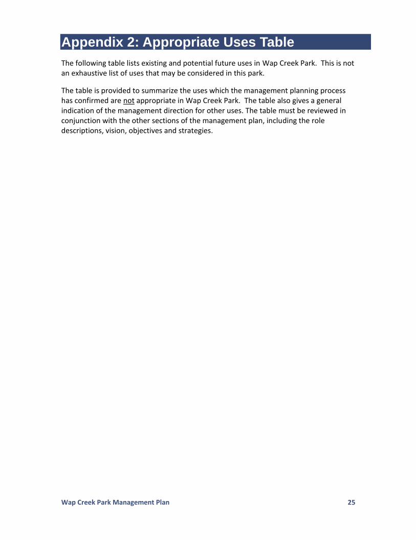
Appendix 2: Appropriate Uses Table
The following table lists existing and potential future uses in Wap Creek Park. This is not an exhaustive list of uses that may be considered in this park.
The table is provided to summarize the uses which the management planning process has confirmed are not appropriate in Wap Creek Park. The table also gives a general indication of the management direction for other uses. The table must be reviewed in conjunction with the other sections of the management plan, including the role descriptions, vision, objectives and strategies.

Wap Creek Park Management Plan
26
Activity/Facility
Appropriate in Nature Recreation
Zone
Appropriate in Cultural Zone
Activities
Exotic Insect/Disease Control Y
Y
Fire Management (prescribed fire management) Y Y
Fire Management (prevention) Y Y
Fire Management (suppression) Y Y
Fish Stocking and Enhancement N N
Grazing (Domestic Livestock) Y1 N
Forest Insect/Disease Control Y Y
Noxious Weed Control Y Y
Scientific Research (manipulative activities) Y Y
Scientific Research (specimen collection) Y Y
Scientific Research (assessment) Y Y
Cultural, ceremonial and social uses by First Nations Y Y
Cultural Tourism Y Y
Boating (power) Y Y
Boating (non-power) Y Y
Camping – backcountry Y (located at current cabin location only)
N
Camping – auto accessible N N
Camping – motorized boat accessible Y (Mabel Lake portion only) N
Commercial Recreation (facility-based) N N
Commercial Recreation (no facilities) Y N
Exotic Pack animal Use N N
Fishing Y (Mabel Lake portion only) N
Hiking/Backpacking/Walking Y Y
Horse/Non-Exotic pack Animal Use Y N
Hunting Y Y
Mechanized Off-road Access (non-motorized – i.e. mountain biking)
Y (on designated roads only) N
Motorized Off-road Access (not snowmobiles – i.e., 4x4, motorcycles, ATV)
N N
Off-road Access (non-mechanical – dog sleds, horse sleds) N N
Skiing (self propelled, not groomed) Y Y
Snowmobiling N (except for authorized trapping tenure)
N (except for authorized
trapping tenure)
Wildlife/Nature Viewing Y Y
Angling Guiding Y (Mabel lake portion only) N
Filming Y N
Guide Outfitting Y (see section 2.5) Y
Trapping Y Y
Facilities/Infrastructure
Administrative Buildings and Compounds N N
Boat Launches N N
Backcountry Huts and Shelters Y (existing cabin site only) N
Campground and Picnic Areas (vehicle accessed and serviced)
N N
Camp sites (other) N (see camping-backcountry) Y (First Nations use only)
Interpretation and Information Buildings N N
Roads and Parking Lots N (located outside park) N
Trails (hiking, cross-country skiing, mountain biking) Y N
Wharves/docks N N
Communication Sites N N
Utility Corridors (power/transmission lines and other rights-of-way
N N
Water Control Structures N N
Water Sampling Structures N N
Wap Creek Park Management Plan
27
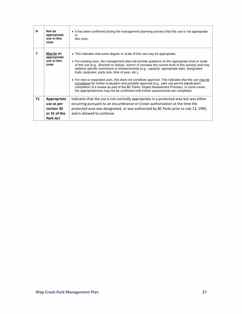
N
Not an appropriate use in this zone
It has been confirmed during the management planning process that this use is not appropriate in this zone.
Y
May be an appropriate use in this zone
This indicates that some degree or scale of this use may be appropriate.
For existing uses, the management plan will provide guidance on the appropriate level or scale of this use (e.g., direction to reduce, restrict or increase the current level of this activity) and may address specific restrictions or enhancements (e.g., capacity, appropriate sites, designated trails, purposes, party size, time of year, etc.).
For new or expanded uses, this does not constitute approval. This indicates that the use may be considered for further evaluation and possible approval (e.g., park use permit adjudication, completion of a review as part of the BC Parks’ Impact Assessment Process). In some cases, the appropriateness may not be confirmed until further assessments are completed.
Y1 Appropriate use as per section 30 or 31 of the Park Act
Indicates that the use is not normally appropriate in a protected area but was either occurring pursuant to an encumbrance or Crown authorization at the time the protected area was designated, or was authorized by BC Parks prior to July 13, 1995, and is allowed to continue.
Wap Creek Park Management Plan
28
Appendix 3: Park Specific Stressors to Maintaining Ecological Integrity
The most significant and immediate stressors to the ecological integrity of the park are listed below: Forest harvesting effects on species movement in and out of the park. Edge effects from forest harvesting immediately along the park boundary (no
buffer zones in place in relation to adjacent cut blocks). Recreational pressures on creek frontage and fish populations (no fishing is
permitted on a large section of Wap Creek - including the park). Expanding footprint of existing cabin site which is used for indiscriminate
camping (fire rings, trampled vegetation and removal of vegetation). Lack of information on species, ecosystems and invasive plants and animals. The adaptation of species to climate change (e.g., species movement and
behavioural changes).


