Planning Committee Meeting – 12 th December 2013 Page 1 WARD: Village 77288/FULL/2011 DEPARTURE: No ERECTION OF 50 SHELTERED APARTMENTS FOR THE ELDERLY INCLUDING COMMUNAL FACILITIES WITHIN A PART THREE STOREY AND PART TWO STOREY BUILDING, FOLLOWING DEMOLITION OF EXISTING CHURCH AND PRESBYTERY. St John the Baptist Church and Presbytery, Thorley Lane, Timperley APPLICANT: Churchill Retirement Living AGENT: Planning Issues Ltd RECOMMENDATION: REFUSE SITE The application site is located on the west side of Thorley Lane to south of the centre of Timperley, close to the junction of Thorley Lane with Shaftesbury Avenue. The site extends to approximately 0.65ha and is vacant following the demolition of the St John the Baptist Roman Catholic Church and an attached former presbytery earlier this year. There are a number of trees to the site frontage and within the grounds of the site, all of which are protected by an area Tree Preservation Order. To the rear part of the site is a large area of hardstanding (former car park) and the remainder of the site is grassed. The site is within a predominantly residential area, being surrounded on all sides by residential property. To both sides of the site there are two storey detached houses on Thorley Lane and Larkhill Close, on the opposite side of Thorley Lane there are detached bungalows and to the rear there are two storey detached houses on Mosley Road. PROPOSAL Permission is sought for erection of a part three storey and part two storey building to provide 50 sheltered apartments for the elderly. The accommodation includes 33 x 1- bed apartments and 17 x 2-bed apartments, a residents lounge and kitchen on the ground floor, laundry on the first floor and guest apartment on the second floor. The plans also indicate an air source heat pump and sub-station adjacent to the building. The development would be Category II type residential sheltered housing (Use Class C3) which is self-contained accommodation for independent retired people. The applicant’s submission describes the development as being specifically designed to meet the needs of independent retired people and provides self-contained apartments for sale. The development includes a lodge manager who is available to assist the owners if necessary, a lift to enable access to all apartments, a communal owners’ lounge, landscaped gardens, a guest suite and laundry facilities. The apartments are sold with a lease containing an age restriction which ensures that only people of 60
Transcript
Planning Committee Meeting – 12th December 2013 Page 1
WARD: Village 77288/FULL/2011 DEPARTURE: No
ERECTION OF 50 SHELTERED APARTMENTS FOR THE ELDERLY INCLUDING COMMUNAL FACILITIES WITHIN A PART THREE STOREY AND PART TWO STOREY BUILDING, FOLLOWING DEMOLITION OF EXISTING CHURCH AND PRESBYTERY. St John the Baptist Church and Presbytery, Thorley Lane, Timperley
APPLICANT: Churchill Retirement Living AGENT: Planning Issues Ltd RECOMMENDATION: REFUSE
SITE The application site is located on the west side of Thorley Lane to south of the centre of Timperley, close to the junction of Thorley Lane with Shaftesbury Avenue. The site extends to approximately 0.65ha and is vacant following the demolition of the St John the Baptist Roman Catholic Church and an attached former presbytery earlier this year. There are a number of trees to the site frontage and within the grounds of the site, all of which are protected by an area Tree Preservation Order. To the rear part of the site is a large area of hardstanding (former car park) and the remainder of the site is grassed. The site is within a predominantly residential area, being surrounded on all sides by residential property. To both sides of the site there are two storey detached houses on Thorley Lane and Larkhill Close, on the opposite side of Thorley Lane there are detached bungalows and to the rear there are two storey detached houses on Mosley Road. PROPOSAL Permission is sought for erection of a part three storey and part two storey building to provide 50 sheltered apartments for the elderly. The accommodation includes 33 x 1-bed apartments and 17 x 2-bed apartments, a residents lounge and kitchen on the ground floor, laundry on the first floor and guest apartment on the second floor. The plans also indicate an air source heat pump and sub-station adjacent to the building. The development would be Category II type residential sheltered housing (Use Class C3) which is self-contained accommodation for independent retired people. The applicant’s submission describes the development as being specifically designed to meet the needs of independent retired people and provides self-contained apartments for sale. The development includes a lodge manager who is available to assist the owners if necessary, a lift to enable access to all apartments, a communal owners’ lounge, landscaped gardens, a guest suite and laundry facilities. The apartments are sold with a lease containing an age restriction which ensures that only people of 60
Planning Committee Meeting – 12th December 2013 Page 2
years or over, or those over this age with a partner of at least 55, can live in the development. The proposed building is T-shaped and predominantly three storey with a lower link section in the centre and two storey elements on each side and to the rear. It would be constructed in red facing brick with red / terracotta tile hanging to the second floor, white uPVC casement style windows and red / terracotta concrete tiles to the roofs. Vehicular access to the site is proposed via the existing access from Thorley Lane. A total of 31 parking spaces would be provided, predominantly to the front of the building. The application originally included demolition of the church and presbytery, which were on the site at the time of submission but both have since been demolished. The Church was listed Grade II by the Department of Culture Media & Sport (DCMS) in September 2011 i.e. after the application had been submitted, however following a successful application by the owners of the church to de-list the building, St John the Baptist was subsequently removed from the statutory list in February 2013. An application for prior approval for demolition of the buildings had previously been submitted to and approved by the Council (ref. 76263/DEMO/2011). DEVELOPMENT PLAN The Development Plan in Trafford Comprises: • The Trafford Core Strategy, adopted 25th January 2012; The Trafford Core
Strategy is the first of Trafford’s Local Development Framework (LDF) development plan documents to be adopted by the Council; it partially supersedes the Revised Trafford Unitary Development Plan (UDP), see Appendix 5 of the Core Strategy.
• The Revised Trafford Unitary Development Plan (UDP), adopted 19th June 2006; The majority of the policies contained in the Revised Trafford UDP were saved in either September 2007 or December 2008, in accordance with the Planning and Compulsory Purchase Act 2004 until such time that they are superseded by policies within the (LDF). Appendix 5 of the Trafford Core Strategy provides details as to how the Revised UDP is being replaced by Trafford LDF.
• The Greater Manchester Joint Waste Plan, adopted 01 April 2012. On 25th January 2012 the Council resolved to adopt and bring into force the GM Joint Waste Plan on 1 April 2012. The GM Joint Waste Plan therefore now forms part of the Development Plan in Trafford and will be used alongside district-specific planning documents for the purpose of determining planning applications.
• The Greater Manchester Joint Minerals Plan, adopted 26th April 2012. On the 13th March 2013, the Council resolved that the Minerals Plan, together with consequential changes to the Trafford Policies Map, be adopted and it came into force on the 26th April 2013. The GM Joint Minerals Plan therefore now forms part of the Development Plan in Trafford and will be used alongside district-specific planning documents for the purpose of determining planning applications.
Planning Committee Meeting – 12th December 2013 Page 3
PRINCIPAL RELEVANT CORE STRATEGY POLICIES L1 - Land for New Homes L2 – Meeting Housing Needs L3 – Regeneration and Reducing Inequalities L4 – Sustainable Transport and Accessibility L5 – Climate Change L7 - Design L8 – Planning Obligations R2 – Natural Environment R3 – Green Infrastructure PROPOSALS MAP NOTATION None PRINCIPAL RELEVANT REVISED UDP POLICIES/PROPOSALS H4 – Release of Other Land for Development NATIONAL PLANNING POLICY FRAMEWORK (NPPF) The DCLG published the National Planning Policy Framework (NPPF) on 27 March 2012. The NPPF sets out the Government’s planning policies for England and how these are expected to be applied. With immediate effect the NPPF replaces 44 documents including Planning Policy Statements; Planning Policy Guidance; Minerals Policy Statements; Minerals Policy Guidance; Circular 05/2005:Planning Obligations; and various letters to Chief Planning Officers. The NPPF will be referred to as appropriate in the report. RELEVANT PLANNING HISTORY 76263/DEMO/2011 – Demolition of existing church, single storey link, presbytery and detached garage (Consultation under Schedule 2, Part 31 of the Town and Country Planning (General Permitted Development) Order 1995). Approved 20/01/11 H/ADV/66228 - Erection of two signs on fence and one free standing sign. Approved 13/03/07 H37674 - Display of non-illuminated free standing sign. Approved 07/09/93 H33570 - Construction of an extension to the existing car park to provide space for 14 additional cars. Approved 19/06/91 APPLICANT’S SUBMISSION The application is accompanied by the following detailed supporting statements: - Planning Statement Design and Access Statement Archaeological Desk Based Assessment Transport Statement
Planning Committee Meeting – 12th December 2013 Page 4
Arboricultural Impact Appraisal and Method Statement Protected Species Survey Report Ecological Scoping Report Desk Study Appraisal (relating to Ground Conditions) Supporting Stakeholder Engagement Statement Flood Risk Assessment Affordable Housing Statement and Viability Appraisal Relevant parts of these statements will be referred to in the Observations section of this report where necessary. CONSULTATIONS LHA – No objections, subject to widening the existing vehicular access into the site to 4.5m to enable simultaneous access and egress (the applicant has been advised of this comment but the plans have not been amended in this regard). Comments summarised in the Observations section of this report. Environment Agency – No objections in principle to the development, subject to a condition requiring a scheme to limit the surface water run-off generated by the development to be submitted and approved prior to commencement of development. The scheme should reduce the surface water run-off rate to 50% compared to the existing. Greater Manchester Ecology Unit – Additional surveys are required to assess the buildings for the presence of hibernating bats and roosts during the active season before the application is determined. The survey has adequately investigated the issue of badgers and reptiles. Conditions are required to ensure that trees and vegetation clearance occurs outside the bird breeding season and that all retained trees are adequately protected during development. Comments summarised in the Observations below. Note – the above comments were made prior to demolition of the buildings and so the comments relating to the need for further surveys of the buildings are no longer applicable. Pollution and Licensing – Comment that the application site is situated on brownfield land and any permission should be subject to a condition requiring a contaminated land Phase I report to assess actual/potential contamination risks at the site and, if necessary, a Phase II investigation and risk assessment and remediation scheme. Greater Manchester Police Design for Security – Comment that such an application would normally be expected to be accompanied by a Crime Impact Statement to identify any potential risks associated with the site context and/or design proposals. Some immediate observations based on the drawings are:
• There are a number of access points to the front of the site, which should be consolidated and centralised.
• Access to the rear of the building must be prevented with appropriate boundary treatments to the side elevations.
Planning Committee Meeting – 12th December 2013 Page 5
• All doors and windows and glazing should be specified to meet Secured by Design standards which we can advise the applicant on in greater detail.
Drainage – Informatives to be attached to any permission relating to storm water attenuation, Sustainable Urban Drainage and drainage to be arranged on a separate system with separate connections to the receiving sewerage network. Highways - No comments Street Lighting - No comments Public Rights of Way – No comments The following organisations were also consulted when the application was originally submitted (prior to the buildings being demolished), however given the subsequent de-listing of the building and its demolition the comments are no longer relevant to the application: - English Heritage – Recommend that the application is withdrawn or refused as being contrary to the Planning (Listed Buildings and Conservation Areas) Act 1990 (as amended) and Government guidance set out in PPS5. A suitable justification for demolishing the church has not been provided in accordance with HE9.2 and other relevant PPS5 policies. (Note PPS5 has since been superseded by the NPPF). Recommend that alternative uses should be explored which retain the church and its special significance are explored. Twentieth Century Society - Strongly object to the application and comment that should the applicants wish to go ahead with their scheme, they would expect to see a Listing Building Consent application with adequate justification according to PPS5 (Note PPS5 has since been superseded by the NPPF). REPRESENTATIONS
Neighbours – A total of 130 objections/comments on the application have been received, of which 124 are in the form of a standardised postcard and 6 letters of objection (from 5 different addresses). Note – these were received in response to the notification letters and advertisement when the application was originally submitted, which was prior to demolition of the buildings. The postcards list the following areas of objection:-
• Traffic danger - accident black spot Shaftesbury Ave/Thorley intersection. • Fear of over development once planning permission is granted. • Traffic hold ups and disruption during the construction period. • Insufficient parking spaces - residents, various staff and medical. Congestion
within and without. • Long term impact on Timperley village parking. • Inflexibility of applicants regarding council recommendations. • Possible alternative religious use. • Loss of beautiful building and new construction could be out of character.
Planning Committee Meeting – 12th December 2013 Page 6
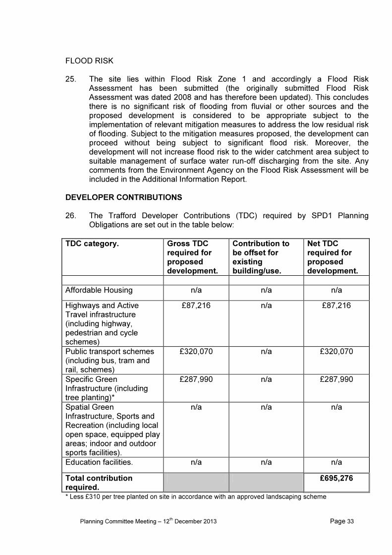
The letters of objection raise the following issues: -
• Insufficient car parking provided. Cars will inevitably park on Thorley Lane which is not suitable, particularly in this narrow part where two-way traffic is not possible when people park outside their houses. The site is also near to a busy road junction.
• One letter suggests 1 space per flat should be provided plus extra parking for visitors and a restriction imposed so no more than one car per flat is allowed. Another letter suggests 75% parking plus visitor parking should be provided.
• Increase in congestion.
• Over-development of the site.
• Detrimental impact on surrounding properties.
• Loss of privacy to 1 Larkhill Close given the number of windows and balcony doors proposed and that the apartments would be occupied effectively all day.
• Impact on Nos. 31 and 33 Mosley Road due to proximity of gable end and impact on the view, daylight and gardens not currently overlooked. No assurances given to guarantee that all trees on this boundary and which form a natural screen will be preserved. The proposed fence is insufficient to provide seclusion from the development and all the groundwork and construction work.
• Disturbance during development, including noise, dust, fumes and disruption.
• Impact on the natural habitat of owls, bats, squirrels and many species of birds.
• Flats would be out of character with surrounding properties.
• Concern over another development for old people in Timperley which is already adequately served.
• Shame that a better use could not be found for the church and a landmark building will be demolished for yet another retirement home.
• Question whether the church has the legal authority to sell the land and demolish the buildings. It is understood the house was given by a family to the church for use as a church presbytery. It would be appropriate for an independent solicitor to check out these considerations.
Following re-consultation on the amended plans one further letter of objection was received, raising the same concerns in respect of over-development, overlooking and parking problems. One postcard in support of the application has been received. OBSERVATIONS PRINCIPLE OF DEVELOPMENT 1. The NPPF includes within its core planning principles the need to deliver the
homes that are needed and states that housing applications should be considered in the context of the presumption in favour of sustainable development. Policy L2 of the Core Strategy (Meeting Housing Needs) states that all new residential development proposals will be assessed for the contribution that will be made to meeting the housing needs of the Borough and the wider aspirations of the Council’s Sustainable Community Strategy. Of
Planning Committee Meeting – 12th December 2013 Page 7
relevance to this application it requires new development to be appropriately located in terms of access to existing community facilities and/or delivers complementary improvements to the social infrastructure, not harmful to the character or amenity of the immediately surrounding area and in accordance with Policy L7 (Design) and other relevant policies within the Development Plan.
2. With regards to older persons accommodation, L2 states in order to meet the
needs arising from the increasing longevity of the Borough’s older residents, the Council will require developers to demonstrate how their proposal will be capable of meeting, and adapting to, the long term needs of this specific group of people. Policy L2 also specifically refers to providing for the “frail elderly” of the Borough and that the Council will seek to meet their needs through allowing 4% of the overall housing land target to be developed as new housing for older person households. This includes ‘extra care’ housing.
3. The site is unallocated in the Adopted Unitary Development Plan and has been
vacant since the buildings were demolished earlier this year. The site is partly grassed and partly hardsurfaced and has characteristics of both previously developed land and greenfield, however given that until recently there were buildings on the site and that there are large hardsurfaced areas remaining the site is considered to constitute previously developed land. The site is within the urban area and a sustainable location given its proximity to local services and facilities in Timperley village only 0.5km further along Thorley Lane. The site is well served by public transport, being within walking distance of bus stops on Thorley Lane and which provide regular services between Timperley and Altrincham and between Altrincham and Stockport. The scheme includes a mix of 1 and 2 bed apartments all of which would be available solely for elderly persons (described by the applicant as over 60, or over 55 with a partner over 60), which is in accordance with Policy L2 of the Core Strategy and guidance in the NPPF aimed at delivering a wide choice of high quality homes and create sustainable, inclusive and mixed communities.
4. Taking the above points into account it is considered the proposal will make
efficient use of previously developed land and which is in a sustainable location, as well contribute to the provision of older person’s accommodation, in accordance with the NPPF, Policies L1 and L2 and the contribution to the Core Strategy’s overall objectives.
IMPACT ON STREET SCENE AND CHARACTER OF THE AREA 5. The NPPF and Core Strategy policy L7 emphasise that new development
should make the most of opportunities to improve the character and quality of an area, the NPPF goes on to say that permission should be refused for developments of poor design that fail to do this.
6. Whilst the building is set back on a similar building line to other buildings on
Thorley Lane and retains appropriate distances to the side boundaries, the proposed building has a substantial footprint extending 62 metres across the site frontage, with a depth of 48 metres projecting towards the rear boundary. It
Planning Committee Meeting – 12th December 2013 Page 8
is considered that the proportion of the site taken up by the building, particularly in respect of its depth and the 3 storey wing projecting to the rear, result in a massing that would be overdominant and out of character with the surrounding area. In the context of the urban grain and suburban character of the surrounding area, the proposed building would dominate the site and appear as an intrusive and significantly more intensive form of development. In particular the distance retained to the rear boundary is considered too close for such a large building; two storey detached houses in the vicinity typically retain a greater distance to their rear boundary than the development and it is considered that a building of the size, height and massing proposed should retain a greater distance. It is acknowledged the design seeks to reduce the massing by including two storey elements to each side and the rear and a lower set back section between the main three storey elements, however it is considered this does not sufficiently break up the massing of the building to avoid being overly dominant for the site. Although there was previously a large building on the site, it is considered misleading to compare the massing of the proposed building to the combined massing of the former church and presbytery on the site, as these were two separate and visually distinct buildings which had a gap between them and less of a continuous eaves and ridge lines extending across the site. Moreover, the previous buildings on the site did not project into or dominate the rear garden scene in the way that the proposed development would.
7. In terms of its height the proposed building is predominantly three storeys,
although includes two storey elements at the sides and to the rear intended to provide a transition to the two storey houses on either side. Nevertheless the three storey elements are significant in width and depth and excessive for the site. It is considered that the site could accommodate some three storey development but in this case the extent of three storey development and particularly the projection to the rear is considered excessive and out of character.
8. In terms of external appearance and materials, the proposed building is to be of
predominantly brick construction with hipped roofs and gabled projections to the front. Materials would be brick to the ground and first floor, tile hanging to the second floor and concrete roof tiles in a red / terracotta colour. The elevation treatment includes an array of gabled projections to the front and side elevations, dormer windows to the side and rear elevations.
9. The design is considered poor and not of a quality that would meet national and
local requirements for new development to be of high quality design and enhance the built environment. Specific elements of the design that give cause for concern are its size, scale and massing; the failure to break the building visually into smaller constituent parts which have a more domestic scale; the gabled projections to the front and to the side elevations of the rear section and the length of uninterrupted ridge to the rear section. The combination of different and substantial roof elements over the various parts of the building, the projections to the front and rear, and the elevational treatment are all considered to result in an incoherent appearance. The new building would appear visually cluttered and as one that has already had a number of
Planning Committee Meeting – 12th December 2013 Page 9
unsympathetic extensions added to it. It is considered the design would fail to take this opportunity for improving the character and quality of the area, as required by national planning guidance in the NPPF (paragraph 64) and Trafford Core Strategy Policy L7. The approach discussed with officers to seek to achieve the appearance of two, three storey villas with elements of reduced scale to the sides and rear and linking the buildings has not been successfully achieved due to the extent and scale of what has been added to the two main three storey elements.
10. The former church and presbytery on the site were considered to be high
quality buildings which made a positive contribution to the area (notwithstanding that they didn’t ultimately merit listed status). Although the site is now vacant, any redevelopment of the site should not be to the detriment of the character of the area and should seek to achieve similar high quality design to the buildings previously on site. In this respect the proposal is contrary to the NPPF which states that pursuing sustainable development involves seeking positive improvements in the quality of the built, natural and historic environment, as well as in people’s quality of life, including (amongst other criteria): replacing poor design with better design (paragraph 9).
IMPACT ON AMENITIES OF ADJACENT RESIDENTIAL OCCUPIERS 11. The Council’s Guidelines for new residential development recommends that
where there would be major facing windows, three storey dwellings should retain a minimum distance of 24m across public highways and 30m across private gardens and for two storey developments the minimum distances are 21m and 27m respectively. Distances to rear garden boundaries from main windows should be at least 13.5m for this type of development. Where there is a main elevation facing a two storey blank gable a minimum distance of 15m should normally be provided.
12. In relation to No. 38 Thorley Lane on the south side of the site the proposed
building would be positioned approximately 8m from the shared boundary at its closest, with the gap increasing to 10.5m at the rear. It would be set back from No. 38 by approximately 7m and at the rear it would extend approximately 19.5m beyond the rear elevation of No. 38. Whilst this would be a significant rearward projection relative to No. 38 it is considered the distance it would be set away from the boundary together with screening provided by existing trees on the boundary ensure the building would not be overbearing from its rear windows or rear garden and would not have a detrimental impact on outlook. It is also relevant to have regard to the fact that the former church was positioned a similar distance from this boundary, extended a similar depth and was higher than the proposed building, therefore the proposed building would have no greater impact than this previous situation. Given its distance from the boundary and being to the north of No. 38 it would not result in loss of light or overshadowing to that property. The only upper floor window proposed in the side elevation nearest No. 38 is to a corridor and this would need to be obscure glazed given it is less than the recommended 10.5m distance from the boundary to ensure no loss of privacy.
Planning Committee Meeting – 12th December 2013 Page 10
13. To the north side of the site the proposed building would retain between 9m to 10m to the boundary with No. 12 Thorley Lane and 28m to the rear facing windows of that dwelling. These distances comply with the above guidelines and are considered sufficient to ensure the development would not be overbearing, although it is acknowledged the building would be highly visible through gaps in the trees along the boundary. With regards to loss of light and overshadowing, it is considered the distance retained to the boundary would be sufficient to ensure no undue loss of light or overshadowing to that property. The only windows proposed in the elevation facing No. 12 at upper floor level are to a bathroom and corridor which it is considered would need to be obscure glazed given they are less than the guideline distance of 10.5m to the boundary.
14. In relation to numbers 1 and 2 Larkhill Close also to the north of the site, the
proposed three storey element projecting to the rear of the site would retain between 19m and 23m to the boundary with these properties. Although there would be a number of windows in this elevation, including balconies on the first floor, the distances retained to the boundary comply with the relevant guidelines of 13.5m to garden boundaries and 30m between facing windows.
15. The rear of the site adjoins the garden boundaries of a number of properties on
Mosley Road. The part of the proposed building nearest this boundary is 2 storey and would retain between 9.5m to 10.5m to the boundary whilst the 3 storey section at the rear would be 16m to 16.5m from the boundary. In the case of the two storey section this elevation includes windows to bedrooms, bathrooms and corridor on the first floor and which would be less than the recommend 13.5m distance. In order to avoid potential overlooking and loss of privacy to the rear the bathroom and corridor windows could be obscure glazed and the bedroom windows could also be obscure glazed given they are not the main window to each bedroom (as the bedrooms would also have a side window). In the case of the three storey section at the rear this would comply with the 13.5m guideline to the boundary and a distance of over 35m would be retained to the rear elevations of the houses directly behind which complies with the 30m guideline. Given its distance from the boundary and having regard to the length of gardens to the properties in Mosley Road it is considered the proposals would not result in a loss of light or overshadowing that would be detrimental to amenity. Concerns about overbearing impact referred to in paragraphs 6 and 7 nevertheless remain.
16. The front elevation of the building would retain distances of 40m or more to the
bungalows on the opposite side of Thorley Lane. This complies comfortably with the guideline of 24m across public highways and ensures there would be no loss of privacy arising from the proposed development, nor would it be visually overbearing at this distance.
TRAFFIC 17. The proposed development is likely to generate more traffic onto Thorley Lane
compared to the former use of the site as a place of worship (other than when
Planning Committee Meeting – 12th December 2013 Page 11
in use at times of worship). The Transport Statement submitted with the application acknowledges this increase but concludes this would not have an adverse effect on the local road network in the context of existing traffic levels and transport infrastructure. The Statement also notes the site is in an accessible location in relation to bus stops, shops and other services and amenities and existing bus services and their frequencies would provide a choice of buses to serve the travel needs of the residents of the proposed development. In terms of traffic generation it is considered the impact of the development on the immediate road network would be acceptable. It is recommended any permission includes a condition requiring a Travel Plan to be prepared and implemented for the development.
ACCESS 18. Vehicle access to and from the site would utilise the existing access
approximately half way along the frontage, with the other entrance on the far left-hand side of the frontage closed off as a vehicle entrance. The LHA comment the vehicular access to the site needs to be 4.5m wide to enable simultaneous access and egress. The proposed access falls slightly short of this standard and therefore would need to be amended to meet this standard.
CAR PARKING 19. The proposed development would provide 31 car parking spaces on site. The
Council’s parking standards for this type of development in this location is 1 space per 2 dwellings, 1 space per residential unit for resident staff and 1 visitor space per 8 dwellings. This equates to 31 spaces and therefore the development is compliant with the standard.
IMPACT ON TREES 20. There are a number of mature trees within the site, particularly along the site
boundaries and also a group behind the existing Church (mostly Limes) which are of significant amenity value to the area and contribute positively to the setting of the building. These trees are the subject of group Tree Preservation Orders and it is considered essential that any redevelopment of the site does not compromise these trees. The plans indicate that the protected group of trees to the rear and those along the frontage are to be retained, with the exception of two Holly’s. The trees and hedging along the site boundaries are to be retained (with the exception of two trees - see below) and the scheme includes additional tree planting to the rear boundary to enhance the existing screening. It is considered that the position of the building relative to protected trees would ensure they would not be compromised by the development.
21. A number of trees are proposed to be removed, including a Horse Chestnut
close to the southern boundary, a small group to the rear and a Hawthorn on the northern side boundary. These trees are all identified in the survey as being of poor form or declining.
IMPACT ON ECOLOGY
Planning Committee Meeting – 12th December 2013 Page 12
22. A Protected Species Survey Report and Ecological Scoping Report have been
submitted with the application, although both were carried out prior to demolition of the buildings. Some of the conclusions and recommendations are therefore no longer applicable to the proposed development.
23. The Ecology Unit has been consulted on the survey and consider the survey
has adequately investigated the issue of badgers and reptiles, however additional work is required to ensure that adequate and reasonable effort has been used to assess the built structures on site for the presence of both hibernating roosts and roosts during the active season. Since these comments were received the buildings have been demolished - this was carried out in accordance with the recommendations of a bat specialist, which included a toolbox talk on site prior to demolition, and also involved liaison with the Ecology Unit and the Greater Manchester Police Wildlife Officer.
24. The Ecology Unit also recommend conditions to ensure that trees and
vegetation clearance occurs outside the bird breeding season and that all retained trees are adequately protected during development to the current British Standard.
FLOOD RISK AND DRAINAGE 25. The site is within a Critical Drainage Area and over 0.5ha; accordingly a Flood
Risk Assessment has been submitted. This concludes that surface water drainage design criteria have been proposed that will ensure the development is safe and secure from flooding and does not pass forward to the downstream catchment flows in excess of current discharges. A completely new surface water drainage system is required to support the proposed development. The Environment Agency has confirmed there is no objection in principle to the development, although as the site is within a critical Drainage Area identified within the Council’s SFRA, the scheme should aim to reduce run-off by 50% compared to the run-off from the existing site. Any permission should include a condition requiring such a scheme to be submitted and approved.
AFFORDABLE HOUSING 26. Policy L2 of the Core Strategy states in respect of all qualifying development
proposals, appropriate provision should be made to meet the identified need for affordable housing. The site is within a “hot” market location (Altrincham) where the affordable housing contribution set out in Policy L2 is 40%.
27. With regards to whether or not this development should require any affordable
housing to be provided, the Council’s SPD on Planning Obligations is relevant and states that any residential use that involves individual units of self-contained residential accommodation, with their own front doors will be regarded as residential and Policy L2 will apply as appropriate. This includes sheltered or age restricted accommodation where it provides self-contained accommodation, even if there is a warden or administrator on site some or all of the time and limited shared facilities (paragraph 3.2.65). The proposed scheme
Planning Committee Meeting – 12th December 2013 Page 13
meets these criteria and therefore affordable housing should be provided. The applicant has submitted an Affordable Housing Statement and Viability Appraisal which suggests a financial contribution towards off-site provision is viable rather than provision of any affordable units within the development (see below).
DEVELOPER CONTRIBUTIONS AND VIABILITY 28. It is appropriate for this form of development to seek the Trafford Developer
Contributions (TDC) required by SPD1 Planning Obligations as set out in the table below:
TDC category Gross TDC required for proposed development.
Contribution to be offset for existing building/use.
Net TDC required for proposed development.
Affordable Housing 20 units n/a 20 units
Highways and Active Travel infrastructure (including highway, pedestrian and cycle schemes)
£2,650 n/a £2,650
Public transport schemes (including bus, tram and rail, schemes)
£10,050 n/a £10,050
Specific Green Infrastructure (including tree planting)
£15,500 n/a £15,500
Spatial Green Infrastructure, Sports and Recreation (including local open space, equipped play areas; indoor and outdoor sports facilities).
£65,218.33 n/a £65,218.33
Education facilities. n/a n/a n/a*
Total contribution required
£93,418.33 and 20 affordable
units *No contribution having regard to SPD1 (paragraph 3.6.2) that certain types of housing such as specialist housing for older people will not directly generate increased demand for school places, and therefore contributions towards educational facilities will not be sought.
29. The applicant has submitted an Affordable Housing Statement and Viability
Appraisal financial appraisal which states for the scheme to be viable it could support a total contribution of £230,000, inclusive of a contribution towards off-site affordable housing. In summary the appraisal states the following: -
Planning Committee Meeting – 12th December 2013 Page 14
• When the application scheme is assessed for economic viability, using the HCA DAT, the proposed development may contribute £138,454 towards off site affordable housing and £93,418 towards other S106 contributions. Contributions above this level would make the scheme unviable and the proposed sheltered housing development would not come forward today, given the current housing market conditions.
• The viability appraisal exercise has been undertaken using the latest appraisal toolkit and utilises up to date build costs provided by the independent BCIS service of the RICS and up to date sales values and follows the latest published RICS guidance on viability in planning.
• For the application scheme to contribute a higher amount to offsite affordable housing would require the developer profit to be reduced to below a level which any specialist developer might reasonably expect in difficult trading conditions or be required to achieve by development loan covenants.
• By granting planning permission and allowing the development of the proposed scheme to come forward, other planning objectives will be achieved; such as the delivery of much needed specialist housing for elderly home owners.
• In addition, by allowing the development to proceed now, construction jobs will be created for the benefit of the local workforce in an industry which has contracted as a result of the downturn in the housing market.
30. The viability assessment is currently under consideration and an update will be
included in the Additional Information Report, together with any necessary amendment to the recommendation.
CONCLUSION 31. The principle of the development is supported and the benefits of the scheme in
terms of providing sheltered accommodation in an entirely appropriate location, making efficient use of previously developed land and the economic and social benefit that the development could bring are acknowledged, however the concerns over design and massing are considered significant enough to override the positive aspects of the scheme.
RECOMMENDATION: REFUSE for the following reason: -
1. The proposed development, by reason of its size, scale, height, depth, massing and design, in particular the design of the external elevations, would be an unsympathetic, overdominant development of the site which would be out of character with the residential scale and urban grain of the surrounding area and detrimental to the visual amenity and character of the street scene and the wider area. The proposed development would fail to take this opportunity for improving the character and quality of the area and would not be a sustainable form of development. As such the proposed development is contrary to Policies L2 and L7 of the Trafford Core Strategy, the Council’s adopted Planning Guidelines: New Residential Development and advice contained within the National Planning Policy Framework.
RG
Planning Committee Meeting – 12th December 2013 Page 15
LOCATION PLAN FOR APPLICATION No: - 77288/FULL/2011
Scale 1:1250 for identification purposes only.
Chief Planning Officer PO Box 96, Waterside House, Sale Waterside, Tatton Road, Sale M33 7ZF Top of this page points North
Planning Committee Meeting – 12th December 2013 Page 16
WARD: Longford 77850/FULL/2011 DEPARTURE: No
CHANGE OF USE FROM PUBLIC HOUSE TO NO.15 SELF-CONTAINED APARTMENTS, INCLUDING EXCAVATION OF GROUND TO EXPOSE BASEMENT LEVEL, CREATION OF STEPS AT GROUND FLOOR TO REAR ELEVATION AND INSERTION OF NEW DOORS AND WINDOWS AT BASEMENT, GROUND AND FIRST FLOOR LEVELS TO ALL ELEVATIONS. 122 Seymour Grove, Old Trafford, M16 0FF
APPLICANT: Mr Basharat Iqbal AGENT: RA Design & Project Management RECOMMENDATION: MINDED TO GRANT SUBJECT TO LEGAL AGREEMENT
This application was considered at the meeting on the 13th September 2012 where the Committee resolved that it was Minded to Grant planning permission subject to a Section 106 agreement (although this agreement has not been completed to date). At this time the application was advertised as proposing 14 self-contained apartments (5 x one bedroom apartments and 9 x two bedroom apartments). Subsequently it has become apparent that some of the information submitted with the application was incorrect and the application actually proposes 15 self-contained apartments (9 x one bedroom apartments and 6 x two bedroom apartments). The proposed plans remain unchanged from what was originally considered, however the description has changed. The application has therefore been brought back to Committee to allow consideration of the implications of the increase in the number of units and changes to the size of the units. SITE
The application relates to a vacant former public house, the Throstles Nest, which is a large two storey building situated on the western side of Seymour Grove. Residential apartments, Hollymount, bounds the site to the north and Old Trafford Conservative Club and residential apartments, Maple Court, bound the site to the south. Skerton Road, which the site has a vehicular access onto, bounds the site to the east. The site has vehicular accesses from both Seymour Grove and Skerton Road. The building also contains a four bedroom residential apartment at first floor level, which was associated with the former public house. Hard standing providing car parking to the public house is situated to the front and rear of the site. PROPOSAL The application proposes a change of use of the site from a public house (including the ancillary residential apartment) to 15 self-contained apartments (9 x one bedroom apartments and 6 x two bedroom apartments). The proposal would include the
Planning Committee Meeting – 12th December 2013 Page 17
excavation of the ground to expose the basement level, the creation of steps to the rear elevation and the insertion of new windows at the basement, ground and first floor
levels to all of the elevations. New doors are also proposed at the basement level to the south, east and west elevations. Car parking to serve the development is proposed to the front and rear of the building. Bin stores are also proposed to the front of the site. DEVELOPMENT PLAN The Development Plan in Trafford Comprises: • The Trafford Core Strategy, adopted 25th January 2012; The Trafford Core
Strategy is the first of Trafford’s Local Development Framework (LDF) development plan documents to be adopted by the Council; it partially supersedes the Revised Trafford Unitary Development Plan (UDP), see Appendix 5 of the Core Strategy.
• The Revised Trafford Unitary Development Plan (UDP), adopted 19th June 2006; The majority of the policies contained in the Revised Trafford UDP were saved in either September 2007 or December 2008, in accordance with the Planning and Compulsory Purchase Act 2004 until such time that they are superseded by policies within the (LDF). Appendix 5 of the Trafford Core Strategy provides details as to how the Revised UDP is being replaced by Trafford LDF.
• The Greater Manchester Joint Waste Plan, adopted 01 April 2012. On 25th January 2012 the Council resolved to adopt and bring into force the GM Joint Waste Plan on 1 April 2012. The GM Joint Waste Plan therefore now forms part of the Development Plan in Trafford and will be used alongside district-specific planning documents for the purpose of determining planning applications.
• The Greater Manchester Joint Minerals Plan, adopted 26th April 2012. On the 13th March 2013, the Council resolved that the Minerals Plan, together with consequential changes to the Trafford Policies Map, be adopted and it came into force on the 26th April 2013. The GM Joint Minerals Plan therefore now forms part of the Development Plan in Trafford and will be used alongside district-specific planning documents for the purpose of determining planning applications.
PRINCIPAL RELEVANT CORE STRATEGY POLICIES L1 - Land for New Homes L2 – Meeting Housing Needs L3 – Regeneration and Reducing Inequalities L4 – Sustainable Transport and Accessibility L7 – Design L8 – Planning Obligations PROPOSALS MAP NOTATION Old Trafford Priority Regeneration Area PRINCIPAL RELEVANT REVISED UDP POLICIES/PROPOSALS None
Planning Committee Meeting – 12th December 2013 Page 18
NATIONAL PLANNING POLICY FRAMEWORK (NPPF) The DCLG published the National Planning Policy Framework (NPPF) on 27 March 2012. The NPPF sets out the Government’s planning policies for England and how these are expected to be applied. With immediate effect the NPPF replaces 44 documents including Planning Policy Statements; Planning Policy Guidance; Minerals Policy Statements; Minerals Policy Guidance; Circular 05/2005:Planning Obligations; and various letters to Chief Planning Officers. The NPPF will be referred to as appropriate in the report. The application site had a number of planning applications in the 1970’s and 1980’s relating to alterations to the public house. The more recent and relevant planning applications relating to the site are: 76929/FULL/2011 - Change of use of part of property from public house with associated flat to four self-contained flats with associated car parking, amenity space and landscaping – Withdrawn November 2011. APPLICANT’S SUBMISSION The applicant has submitted a design and access statement. The information provided within the statement will be referred to where relevant in the Observations section of this report. CONSULTATIONS LHA – No objections, further comments are discussed within the Observations section of this report. REPRESENTATIONS
No further comments have been received from neighbouring residents since the application was last considered by the Planning Committee. The last report detailed that one letter of objection had been received from a neighbouring resident on Whalley Grove, raising concerns about the loss of the public house, which they state with the right approach can encourage social cohesion. They are further concerned that once the public house is converted for residential use that it would be near impossible to change it back again. OBSERVATIONS PRINCIPLE OF PROPOSAL
1. The change of use of the premises from a public house to residential apartments, including the provision of one-bedroom apartments was agreed in principle when it was last presented to the Planning Committee. There has been no change in local and national planning policies since this resolution.
Planning Committee Meeting – 12th December 2013 Page 19
Although the revised proposal includes the provision of a higher number of one-bedroom apartments than previously proposed (an increase from 5 to 9), 6 two-bedroom apartments would also be proposed, thus providing a mix of accommodation in accordance with Policy L2 of the Core Strategy. It is therefore considered that the revised proposal is considered acceptable in principle.
RESIDENTIAL AND VISUAL AMENITY
2. The layout of the proposed development, as shown on the submitted plans, has not changed from what was previously considered by the Planning Committee. The impact of the proposed development on surrounding residents therefore continues to be considered acceptable.
3. The proposed external alterations to the building and surrounding site also remain unchanged from what was previously considered by the Planning Committee. Therefore the visual impact of the proposed development also continues to be considered acceptable.
HIGHWAY SAFETY AND PARKING PROVISION
4. To meet the Council’s car parking standards for 9 one-bedroom apartments and 6 two-bedroom apartments, 21 car parking spaces are required. The application proposes the provision of 23 car parking spaces in a layout that ensures that simultaneous access and egress can be achieved around the site. The application also includes the provision of cycle car parking. A condition is recommended to ensure that the car and cycle parking provision is created and retained.
DEVELOPER CONTRIBUTIONS
5. The Trafford Developer Contributions (TDC) required by SPD1 Planning Obligations are set out in the table below:
TDC category. Gross TDC required for proposed development.
Contribution to be offset for existing building/use.
Net TDC required for proposed development.
Affordable Housing 0 N/A 0
Highways and Active Travel infrastructure (including highway, pedestrian and cycle schemes)
£795.00 £9,205.00 £0
Public transport schemes (including bus, tram and rail, schemes)
£2,415.00 £8137.00 £0
Specific Green Infrastructure (including
£4,650.00 £4,960.00 £0
Planning Committee Meeting – 12th December 2013 Page 20
tree planting)
Spatial Green Infrastructure, Sports and Recreation (including local open space, equipped play areas; indoor and outdoor sports facilities).
6. The existing use of the site as a public house with a four bedroom apartment
would generate a higher contribution than the proposed development in the Highways and Active Travel infrastructure, Public Transport schemes and Specific Green Infrastructure categories. Therefore the only contributions triggered by the development are those towards Spatial Green Infrastructure, Sports and Recreation and Education Facilities.
7. The overall financial contribution was previously £43,317.62; this is now reduced as there are a greater number of one-bedroom apartments and a reduced number of two-bedroom apartments now proposed.
CONCLUSION
8. The previous report concluded that the conversion of the public house to self-
contained apartments, in a sustainable location, is considered to be acceptable and to not unduly impact on residential amenity and highway safety. The proposed works to the external appearance of the building were also considered acceptable and in keeping with the host building and character of the surrounding area. The report also stated that the proposal would create a sustainable form of development that would deliver the three main roles, economic, social and environmental, as outlined in the NPPF.
9. It is considered that the revisions detailed within this report are also acceptable
and would result in a sustainable form of development, in accordance with the NPPF and in compliance with all relevant Policies in the Core Strategy and related Supplementary Planning Guidance. The application is therefore recommended for approval subject to the necessary S106 agreement.
RECOMMENDATION: MINDED TO GRANT SUBJECT TO LEGAL AGREEMENT
(A) That the application will propose a satisfactory development for the site upon completion of an appropriate legal agreement to secure a maximum financial contribution of £29,278.11 split between maximum contributions towards Spatial Green Infrastructure, Sports and Recreation £18,172.68 and Education Facilities £11,105.43.
Planning Committee Meeting – 12th December 2013 Page 21
(B) In the circumstances where the S106 Agreement has not been completed within 3 months of the resolution to grant planning permission, the final determination of the application shall be delegated to the Head of Planning;
(C) That upon satisfactory completion of the above legal agreement, planning
permission be granted subject to the following conditions: 1. Standard Time Limit 2. List of Approved Plans 3. Materials 4. Colour Treatment of Railings 5. Landscaping including layout of amenity space and approved amenity space to be
retained thereafter 6. Landscape Maintenance 7. All areas of the manoeuvring and parking of vehicles shall be made available for
such and retained at all times. 8. Provision of cycle parking
VW
Planning Committee Meeting – 12th December 2013 Page 22
LOCATION PLAN FOR APPLICATION No: - 77850/FULL/2011
Scale 1:1250 for identification purposes only.
Chief Planning Officer PO Box 96, Waterside House, Sale Waterside, Tatton Road, Sale M33 7ZF Top of this page points North
Planning Committee Meeting – 12th December 2013 Page 23
WARD: Davyhulme East
80470/O/2013 DEPARTURE: No
OUTLINE APPLICATION FOR REDEVELOPMENT OF SITE TO PROVIDE UP TO 27,870 SQ M (INTERNAL) OFFICES (B1), A 150 BED HOTEL (C1) AND DECKED CAR PARKING, TOGETHER WITH ASSOCIATED HIGHWAY ACCESS AND LANDSCAPING. DETAILS OF ACCESS APPLIED FOR WITH ALL OTHER MATTERS RESERVED (APPEARANCE, LANDSCAPING, LAYOUT AND SCALE). Former Kratos Site, Barton Dock Road, Trafford Park, M41 7BQ
APPLICANT: Peel Investments North Ltd AGENT: RECOMMENDATION: MINDED TO GRANT SUBJECT TO LEGAL AGREEMENT
SITE The application relates to a vacant site former industrial site situated on the western side of Trafford Park near to the Trafford Centre. The site is on the north east side of Barton Dock Road between Park Way (A5081) to the east and Mercury Way to the west. It extends to approximately 3.8 hectares and has been cleared of buildings (previously there were industrial buildings on the site). Access into the site is currently via Mercury Way on the north west side of the site. Barton Dock Road runs along the south western boundary of the site and Mercury Way along the north western boundary. The south eastern boundary is formed by screen planting, beyond which is a slip road and Park Way. To the north west on the opposite side of Mercury Way is the Event City Exhibition Centre and further along Mercury Way is a large warehouse (Regatta). To the north east there are smaller industrial units with access from Cobalt Avenue PROPOSAL Outline planning permission is sought for the erection of offices to provide up to 27,870 sq. m (internal) office space (Use Class B1) and a 150 bed hotel (Use Class C1) of 5,700 sq. m and decked car parking, together with associated highway access and landscaping The application is made in outline with details of access submitted for approval and all other details (appearance, landscaping, layout and scale) reserved for subsequent approval. The indicative layout shows 4 buildings (the hotel and 3 x office buildings), a multi-storey car park, surface parking and associated highway access and landscaping. The hotel is indicated as being a 5 storey / 20m high building positioned on the corner of Barton Dock Road and Mercury Way whilst the office buildings comprise a 7 storey building next to the proposed hotel fronting Barton Dock Road and two 4 storey
Planning Committee Meeting – 12th December 2013 Page 24
buildings fronting Mercury Way. All offices are indicated as having 20,000 sq. ft. floor plates (approx. 1858 sq. m). Access to the site is proposed from three positions on Mercury Way and the existing access from Barton Dock Road is to be closed off. Although three access points are shown on the indicative layout plan, the applicant’s statement refers to two access points being proposed - the applicant has been asked to clarify this point and confirmation will be included in the Additional Information Report. The submission states 1,080 car parking spaces are proposed (the layout plan refers to 930+ spaces in the proposed multi-storey car park and 161 surface parking spaces which would result in 1,091+ spaces). DEVELOPMENT PLAN The Development Plan in Trafford Comprises: • The Trafford Core Strategy, adopted 25th January 2012; The Trafford Core
Strategy is the first of Trafford’s Local Development Framework (LDF) development plan documents to be adopted by the Council; it partially supersedes the Revised Trafford Unitary Development Plan (UDP), see Appendix 5 of the Core Strategy.
• The Revised Trafford Unitary Development Plan (UDP), adopted 19th June 2006; The majority of the policies contained in the Revised Trafford UDP were saved in either September 2007 or December 2008, in accordance with the Planning and Compulsory Purchase Act 2004 until such time that they are superseded by policies within the (LDF). Appendix 5 of the Trafford Core Strategy provides details as to how the Revised UDP is being replaced by Trafford LDF.
• The Greater Manchester Joint Waste Plan, adopted 01 April 2012. On 25th January 2012 the Council resolved to adopt and bring into force the GM Joint Waste Plan on 1 April 2012. The GM Joint Waste Plan therefore now forms part of the Development Plan in Trafford and will be used alongside district-specific planning documents for the purpose of determining planning applications.
• The Greater Manchester Joint Minerals Plan, adopted 26th April 2012. On the 13th March 2013, the Council resolved that the Minerals Plan, together with consequential changes to the Trafford Policies Map, be adopted and it came into force on the 26th April 2013. The GM Joint Minerals Plan therefore now forms part of the Development Plan in Trafford and will be used alongside district-specific planning documents for the purpose of determining planning applications.
PRINCIPAL RELEVANT CORE STRATEGY POLICIES SL4 – Trafford Centre Rectangle L4 – Sustainable Transport and Accessibility L5 – Climate Change L7 - Design L8 – Planning Obligations
Planning Committee Meeting – 12th December 2013 Page 25
W1 – Economy W2 – Town Centres and Retail R3 – Green Infrastructure R6 – Culture and Tourism PROPOSALS MAP NOTATION Trafford Centre and its Vicinity The Village Business Park and Centre Special Health and Safety Development Control Sub-Area PRINCIPAL RELEVANT REVISED UDP POLICIES/PROPOSALS TCA1 – The Trafford Centre and its Vicinity TP6 –Village Business Park and Centre D5 – Special Health and Safety Development Control Sub-areas E3 – Land for Commercial Office Development S11 – Development outside Established Centres NATIONAL PLANNING POLICY FRAMEWORK (NPPF) The DCLG published the National Planning Policy Framework (NPPF) on 27 March 2012. The NPPF sets out the Government’s planning policies for England and how these are expected to be applied. With immediate effect the NPPF replaces 44 documents including Planning Policy Statements; Planning Policy Guidance; Minerals Policy Statements; Minerals Policy Guidance; Circular 05/2005:Planning Obligations; and various letters to Chief Planning Officers. The NPPF will be referred to as appropriate in the report. RELEVANT PLANNING HISTORY H/OUT/70189 - Outline planning application for demolition of existing buildings and erection of two office buildings (maximum 27,870 square metres) falling within Class B1 together with associated car parking and ancillary structures. Consent sought for creation of access from Mercury Way with all other matters reserved. Approved 20/03/2009 H/OUT/66496 - Outline planning application for demolition of existing buildings and erection of a new 10,000 square metre office building (use Class B1) with consent sought for details of access and all other matters reserved. Approved 28/05/2008 APPLICANT’S SUBMISSION The applicant has submitted the following information in support of the application:- Planning Statement Transport Assessment Flood Risk Assessment Air Quality Assessment
Planning Committee Meeting – 12th December 2013 Page 26
During the course of the application the applicant submitted a further supporting statement and Counsel Opinion relating to the need for the application to include a sequential test – this is referred to where relevant below. CONSULTATIONS LHA – No objections. Comments summarised in the Observations below. Highways Agency – No objections, subject to a condition requiring a detailed travel plan to be submitted and approved. Comments summarised in the Observations below. TfGM – Support the principle of the re-development of the site. Suggest conditions requiring 1) the applicant to demonstrate the approved plans incorporate the proposed Metrolink scheme shown on adjacent to the site and 2) detailed design of the junction will need to be approved by TfGM. Greater Manchester Police (Design for Security) – No comments received. Any comments will be included in the Additional Information Report. Manchester City Council - The Council has concerns relating to the office element of the application and evidence relating to impact, the sequential approach and the role of this development within wider plans for the Strategic Location is required. Comments summarised in the Observations section of this report. Salford City Council – A scheme of this significance could have the potential to impact on the City and Regional Centre, in particular given its proximity to MediaCity UK and other town centres such as Eccles, and a comprehensive assessment in respect of the sequential approach to town centres should be undertaken. Comments summarised in the Observations section of this report. Environment Agency - Comments on the updated Flood Risk Assessment not yet received. Any comments will be included in the Additional Information Report. Pollution & Licensing – The site is situated on brownfield land and as such a condition requiring a contaminated land Phase I report to assess actual/potential contamination risks and a Phase II report as necessary is recommended. Recommend conditions requiring an acoustic assessment in relation to the amenity of future occupiers of the development and an air quality assessment in relation to the car parking and vehicle movements (an air quality assessment has in fact already been submitted). United Utilities – No comments received Electricity North West – Comment the application could have an impact on their infrastructure. Applicant to be informed of comments.
Planning Committee Meeting – 12th December 2013 Page 27
REPRESENTATIONS
2 letters received summarised as follows: -
• Need to ensure highway access and egress with Mercury Way is improved. The junction is already difficult and dangerous, with high volume of traffic along both Barton Dock Road and Mercury Way. This has become increasingly difficult with the change of use of the nearby distribution centre to ‘Event city’. The current T-junction already needs replacement with a traffic management solution as a roundabout or lights. Increased traffic volume because of the proposed hotel will add to this existing hazard.
• Highly in favour of the application which will bring a positive benefit to the area and surrounding properties. It will create a positive visual impact and also deter the level of break-ins and associated vandalism as the site has been derelict for a while and caused issues for other local properties over the years.
OBSERVATIONS PRINCIPLE OF DEVELOPMENT 1. The site lies within the Trafford Centre Rectangle Strategic Location as defined
in Policy SL4 of the Core Strategy. This policy seeks the major mixed-use development of this area including, amongst other things, commercial and leisure facilities; the delivery of 15 hectares of land employment activity, a proportion of which is suitable for high quality commercial (B1) development, in line with Policy W1; and a high quality (4* minimum) hotel and conference facility in the region of 200 bed spaces located close to Junction 9 of the M60.
2. Core Strategy Policy W1.3 identifies the Trafford Centre Rectangle as a focus
for employment uses. Specifically, Policy W1.5 states that “�B1 office development will be appropriate�at Trafford Centre Rectangle where it is accessible by sustainable transport modes and meets other relevant criteria in national planning guidance�” Table W1 indicates a target of 15 hectares of land for new employment development within Trafford Centre Rectangle by 2026.
3. Core Strategy Policy R6 (Culture and Tourism) is relevant to the hotel element
of this proposal and states the Council will encourage and continue to support the tourism offer in accordance with national guidance and policies and the Development Plan in key areas, which include the Trafford Centre Rectangle Strategic Location.
4. Both offices and hotels are defined as a main town centre use in the NPPF and
this site is not within a designated town centre. Government guidance set out in the NPPF requires local planning authorities to apply a sequential test to planning applications for main town centre uses that are not in an existing centre and are not in accordance with an up-to-date Local Plan (paragraphs 24
Planning Committee Meeting – 12th December 2013 Page 28
to 27). Policy W2 of the Core Strategy (Town Centres and Retail) sets out the policy position for out of centre developments and states that there will be a presumption against the development of retail, leisure and other town centre type uses except where it can be demonstrated that they satisfy the tests outlined in current Government guidance. The tests set out in the NPPF are follows: -
• Local planning authorities should require applications for main town centre uses to be located in town centres, then in edge of centre locations and only if suitable sites are not available should out of centre sites be considered. When considering edge of centre and out of centre proposals, preference should be given to accessible sites that are well connected to the town centre. Applicants and local planning authorities should demonstrate flexibility on issues such as format and scale.
• When assessing applications for retail, leisure and office development outside of town centres, which are not in accordance with an up-to-date Local Plan, local planning authorities should require an impact assessment if the development is over a proportionate, locally set floorspace threshold (if there is no locally set threshold, the default threshold is 2,500 sq. m).This should include assessment of the impact of the proposal on existing, committed and planned public and private investment in a centre or centres in the catchment area of the proposal; and the impact of the proposal on town centre vitality and viability, including local consumer choice and trade in the town centre and wider area, up to five years from the time the application is made. For major schemes where the full impact will not be realised in five years, the impact should also be assessed up to ten years from the time the application is made.
• Where an application fails to satisfy the sequential test or is likely to have significant adverse impact on one or more of the above factors, it should be refused.
5. Both Manchester City and Salford City Councils have raised concern over the
absence of a sequential test and the potential to impact on the City and Regional Centre, including Manchester, Stretford and Eccles.
Manchester City Council has concerns relating to the office element of the application, referring to there clearly being potential outlined for significantly more development in the Trafford Centre Rectangle beyond proposals for the Kratos site. The Trafford Rectangle is regionally significant and development should be progressed in a coordinated and clearly planned manner, with clear evidential links to its target market and the wider economic offer of the City Region. The issue of impact is not resolved through Policy SL4 and therefore the issue remains to be considered against national policy. A properly informed decision relies on evidence relating to impact, the sequential approach and the role of this development within the wider plans for the Strategic Location, and that this approach reflects local and national planning policies. Currently, no such evidence has been submitted by the applicant.
Planning Committee Meeting – 12th December 2013 Page 29
Salford City Council comment that whilst Policy SL4 identifies the potential for a hotel close to junction 9 of the M60 along with commercial development on the Kratos site, this must be considered in light of existing consents for these uses in this area. A scheme of this significance could have the potential to impact on the City and Regional Centre, in particular given its proximity to MediaCityUK, as well as other town centres such as Eccles. The PPS4 statement submitted in support of Trafford’s Core Strategy states that “Office development within Trafford Park / Trafford Centre Rectangle / Old Trafford, whilst at a lower level than that proposed in Pomona / Wharfside, may still have impacts on existing centres. Too much speculative office development in these locations could affect investment in and vitality and viability of centres such as Manchester, Stretford and Eccles. There is a particular concern that over-provision within the Trafford Centre Rectangle could affect schemes within Manchester City Centre given the similarities in attractions for the higher end of the office market”. It is therefore important that a comprehensive assessment in respect of the sequential approach to town centres is undertaken in relation to this proposal.
6. No such sequential test as referred to by the NPPF has been submitted in
support of this application. In response to this requirement the applicant has submitted a report and advice from Leading Counsel which in summary states that the proposal complies with the Trafford Core Strategy and therefore in NPPF parlance, complies with the provisions of an up to date Development Plan, which itself was prepared and adopted following full consideration of all relevant issues, including application of the sequential test and consideration of town centre impacts. Therefore under the clear terms of the NPPF, there is no requirement for an application which complies with a Development Plan allocation, even one on an out of centre site, to duplicate and repeat the sequential and impact testing already carried out by the LPA before its own decision to allocate that site.
7. The application proposes a very significant amount of new BCO Grade A office
floorspace (27,800 sq. m) within this location. As a main town centre use in an out of centre location, this proposal can be considered appropriate where it is shown to be accessible and meets the relevant national tests (which includes paras 24 to 27 of NPPF) as set out in Core Strategy Policy W1.5, and where it is in accordance with Core Strategy Policy SL4.2 in terms of an appropriate proportion of employment land for B1 office development within the Trafford Centre Rectangle Strategic Location.
8. The site lies on Barton Dock Road which is identified as a Quality Bus Corridor.
The site can therefore be considered to be highly accessible by a choice of means of transport.
9. The applicant argues that the proposal cannot be considered in terms of the
sequential or impact tests set out in NPPF para 24 and 26 because it is consistent with an up-to-date development plan, in particular Core Strategy Policies W1 and SL4. It is accepted that this proposal for the development of approx. 3 hectares of land for new office development would contribute to the target of 15 hectares of employment land to be developed within Trafford Centre Rectangle as set out in Core Strategy Policy W1. In addition, the
Planning Committee Meeting – 12th December 2013 Page 30
proposal would, along with existing commitments (at Trafford Quays, Junction 10 of the M60 and the recent decision on the Regatta site), mean that a total of approximately 12 hectares of land within Trafford Centre Rectangle would be available for B1 office development. It is considered that this would constitute an ‘appropriate proportion’ of land for high quality commercial (B1) development, referred to in Core Strategy Policy SL4.2.
10. It should be noted that the applicant has not provided justification of the need
for more office development to meet specific requirements within TCR nor any mention of a specific operator or operators. Therefore this proposal would, if approved, in combination with the outstanding 39,800sqm of committed office floorspace elsewhere within TCR, result in a very significant amount of BCO Grade A office floorspace that, at present, is not seeking to meet a specific need or occupier requirement and should, therefore, be considered as speculative development.
11. Notwithstanding this, the office element of the proposal is consistent with Core
Strategy Policies SL4 and W1 in that it will support the delivery of major mixed-use development by contributing to the delivery of employment land within Trafford Centre Rectangle Strategic Location of a sufficient quality and quantity in hectarage terms.
12. In terms of the hotel element, proposals for a hotel at TCR in addition to the
outstanding permission for a 4* hotel at Junction 9 of the M60 (Planning Application Ref: 80868/RENEWAL/2013) should be dealt with in relation to CS Policy W2.12 i.e. considered against the national tests in NPPF paras 24 to 27.
13. In relation to the sequential test, the applicant has demonstrated in paras 4.9 to
4.13 of their development supporting statement (October 2013) that there is a very significant need for a hotel of this type in this particular location due, primarily to the demand created by EventCity. Therefore, it is considered that there are no suitable sites within existing town centres that would be likely to be capable of meeting the same requirements as the application site. Therefore the hotel element of the proposal is consistent with the Sequential Test as set out in paragraph 24 of NPPF and Policy W2.12 of the Core Strategy. In addition, it follows that, as the need for this proposal is limited to the TCR, there would be a limited impact on any town centres.
14. In conclusion this application is consistent with the specific designation in Core
Strategy Policy SL4.2. It is considered that the proposal is also acceptable in terms of the quality and quantity of employment development proposed and is therefore consistent with Policy W1 of the Adopted Core Strategy.
HIGHWAY ISSUES 15. A Transport Statement has been submitted and concludes that the traffic
impact on the area of interest is minimal, with no significant reduction in capacity or increase in queuing. It concludes there are no transport related reasons preventing planning consent. The Transport Statement has been assessed by the LHA and Highways Agency and in terms of trip generation the
Planning Committee Meeting – 12th December 2013 Page 31
proposals are considered acceptable. The Highways Agency has raised no objections following discussions and the submission of further information by the applicant. In summary they advise the impact of the development on both the average journey time and maximum queue length along M60 junctions 8 to 10 is acceptable. The development does not result in a severe impact on the strategic road network.
16. Both the Highways Agency and LHA advise that a Travel Plan is required for
the proposed hotel and office uses. Although a Travel Plan has been submitted with the application, no targets are included within the report and a full and thorough approach to targets and measures should be provided.
17. It is proposed signalise the junction of Mercury Way / Barton Dock Road to
improve the congestion currently experienced on Mercury Way where vehicles currently have to give way to traffic on Barton Dock Road. The signalization will provide a pedestrian crossing facility across the junction but will also create additional queues on Barton Dock Road. The proposals are considered acceptable although the detailed design will need to be agreed with TfGM’s UTC and the full cost of the junction redesign and installation and a commuted sum paid (for maintenance of the junction) to be funded by the developer. The LHA also require the developer to fund amendments to the Traffic Regulation Orders on Mercury Way to keep the road clear in proximity of the signal controlled junction.
Access Arrangements 18. Access to the site is proposed from three positions on Mercury Way which is a
no through road that serves a number of sites from Barton Dock Road. The first to serve the proposed hotel and surface parking within the southern part of the site and the other two will serve the communal parking areas. The office buildings each have laybys proposed within the site in close proximity to each building for servicing. The existing access onto Barton Dock Road is to be closed through a stopping up process.
Car Parking 19. The application states 1,080 car parking spaces would be provided and the
proposed layout shows 930+ spaces would be provided in a multi-storey car park and approx. 161 surface parking spaces provided adjacent to the hotel. To meet the Council’s car parking standards the provision of 929 car parking spaces are required for the offices, 25 of the spaces should be laid out as disabled bays. In addition the provision of 93 cycle parking spaces and 37 motorcycle parking spaces. For the hotel the provision of 150 car parking spaces should be provided, 9 of which should be disabled bays, and 15 cycle parking spaces and 6 motorcycle parking spaces should be provided.
20. The number of spaces proposed meets the Council’s parking standards.
Detailed layouts and operation have not been provided at this stage and therefore the LHA is unable to comment on the design. The LHA request that a condition is attached to any permission that the multi-storey car park can only
Planning Committee Meeting – 12th December 2013 Page 32
be used by users of the development only and users should not be charged for use of the car park, as this would lead to an increase in parking on local roads.
21. No cycle or motorcycle parking provision with a sufficient level of detail has
been submitted at this stage; however point 4.6 of the TA states that this will be provided in line with the Council’s Core Strategy Parking Standards. The LHA has requested this is added as a condition and would state that the proposed cycle park is not sighted in a well overlooked and secure location. Cycle parking should be located closer to the building to be as direct and attractive for use as possible.
METROLINK 22. The proposed Metrolink extension to Trafford Park and the Trafford Centre
would run alongside the south east and south west sides of the site (alongside Parkway and Barton Dock Road). The proposals include provision of an easement for this line and the applicant has had discussions with TfGM. TfGM has no objections subject to conditions requiring the following: -
• No development to commence until applicant has demonstrated that the approved plans incorporate the proposed Metrolink scheme shown on drawing no. MMD-243243-BJ-DWG-017 rev P3. Scheme to include, but not be limited to, the potential future Metrolink corridor and the likely requirements on the approaches to and within the application site, so far as is known at this time.
• As part of Section 278 works, detailed design of the junction will need to be approved by TfGM on behalf of GMCA for traffic signals for which a commuted sum for future maintenance and operating costs will be required. The detailed design of the proposed Mercury Way / Barton Dock Road junction will form part of the reserved matters for future approval.
Manchester City Council has also stated they would support steps to secure a financial contribution from this development that would strengthen the business case for the investment in public transport.
AIR QUALITY 23. An Air Quality Assessment has been submitted with the application, although to
date this has not been assessed by the Council’s Pollution and Licensing Section. Comments will be included in the Additional Information Report.
APPEARANCE, LAYOUT AND DESIGN 24. The indicative layout identifies the location for each of the uses proposed, the
amount of development proposed for each use and scale parameters including height, width and length of each building. Having regard to the size of the site and the character of the surrounding area it is considered the indicative scheme is acceptable in these terms. Matters of appearance, layout and scale are reserved for subsequent approval and so not for consideration at this stage.
Planning Committee Meeting – 12th December 2013 Page 33
FLOOD RISK 25. The site lies within Flood Risk Zone 1 and accordingly a Flood Risk
Assessment has been submitted (the originally submitted Flood Risk Assessment was dated 2008 and has therefore been updated). This concludes there is no significant risk of flooding from fluvial or other sources and the proposed development is considered to be appropriate subject to the implementation of relevant mitigation measures to address the low residual risk of flooding. Subject to the mitigation measures proposed, the development can proceed without being subject to significant flood risk. Moreover, the development will not increase flood risk to the wider catchment area subject to suitable management of surface water run-off discharging from the site. Any comments from the Environment Agency on the Flood Risk Assessment will be included in the Additional Information Report.
DEVELOPER CONTRIBUTIONS 26. The Trafford Developer Contributions (TDC) required by SPD1 Planning
Obligations are set out in the table below:
TDC category. Gross TDC required for proposed development.
Contribution to be offset for existing building/use.
Net TDC required for proposed development.
Affordable Housing n/a n/a n/a
Highways and Active Travel infrastructure (including highway, pedestrian and cycle schemes)
£87,216 n/a £87,216
Public transport schemes (including bus, tram and rail, schemes)
£320,070 n/a £320,070
Specific Green Infrastructure (including tree planting)*
£287,990 n/a £287,990
Spatial Green Infrastructure, Sports and Recreation (including local open space, equipped play areas; indoor and outdoor sports facilities).
n/a n/a n/a
Education facilities. n/a n/a n/a
Total contribution required.
£695,276
* Less £310 per tree planted on site in accordance with an approved landscaping scheme
Planning Committee Meeting – 12th December 2013 Page 34
** TDC contributions, specifically those in relation to the proposed hotel use, are subject to further consideration by TfGM and the Council. The final figure may be subject to minor change prior to the completion of the S106. Further update to be provided in the Additional Information Report.
CONDITIONS 27. There may be requirement for some of the conditions below, including
implementation of the highway works, to reflect the potential phasing of different parts of the development by the applicant. Details of proposed phasing of the development are not known to date and further discussion with the applicant will be needed. The wording of some of the recommended conditions below may need to be amended to reflect this.
RECOMMENDATION: MINDED TO GRANT SUBJECT TO LEGAL AGREEMENT (A) That the application will propose a satisfactory form of development for the site
upon completion of an appropriate legal agreement to secure a maximum financial contribution of £695,276 split between: £87,216 towards Highway and Active Travel infrastructure; £320,070 towards Public Transport Schemes; and £287,990 towards Specific Green Infrastructure (to be reduced by £310 per tree planted on site in accordance with an approved landscaping scheme); and
(B) In the circumstances where the S106 Agreement has not been completed within 3
months of the resolution to grant planning permission, the final determination of the application shall be delegated to the Head of Planning.
(C) That upon satisfactory completion of the above legal agreement, planning
permission be GRANTED subject to the following conditions: - 1. An application for approval of reserved matters shall be made to the Local
Planning Authority not later than the expiration of three years beginning with the date of this permission and the development shall be begun not later than the expiration of two years from the final approval of the reserved matters.
2. (a). No development shall take place without the prior written approval of the Local Planning Authority of the reserved matters, that is, details of: (i) the layout, (ii) the scale, (iii) the appearance, (v) the landscaping of the site (including any proposed changes to existing ground levels, means of enclosure and boundary treatment, hard surfaced areas and materials planting plans, specifications and schedules, existing plants to be retained and showing how account has been taken of any underground services). (b) The approved proposals relating to means of access and to landscaping shall be carried out respectively before and within 12 months from the date when any of the buildings hereby permitted are occupied; any trees or shrubs planted in accordance with this condition which are removed, uprooted, destroyed, die or become severely damaged or seriously diseased within 5 years of planting shall be replaced within the next planting season by trees or shrubs of similar size and
Planning Committee Meeting – 12th December 2013 Page 35
species to those originally required to be planted, unless the Local Planning Authority give its written consent to any variation.
3. All reserved matters shall accord with the general layout of the site, and the scale and height of the buildings as set out in the drawing number 433-KTP
4. Contaminated land assessment 5. No development to commence until applicant has demonstrated that the approved
plans incorporate the proposed Metrolink scheme shown on drawing no. MMD-243243-BJ-DWG-017 rev P3. Scheme to include, but not be limited to, the potential future Metrolink corridor and the likely requirements on the approaches to and within the application site, so far as is known at this time.
6. Prior to any part of the development being brought into use, the detailed design of the traffic light junction at Mercury Way / Barton Dock Road shall be submitted to and approved by the LPA, including the need to be approved by TfGM, and brought into use.
7. The development shall not be brought into use unless and until Traffic Regulation Orders on Mercury Way have been introduced in accordance with a scheme which shall first be submitted to and approved in writing by the Local Planning Authority.
8. Travel Plan to be submitted and approved 9. Details of cycle and motorcycle parking to be submitted and in accordance with
Council’s standard 10. Detailed plans of internal road and car park layouts to be submitted and approved,
provided in accordance with the approved plans and retained thereafter 11. Car parking management strategy to be submitted and approved, including details
of any charging schedule and users of car park 12. Acoustic Assessment to be submitted and approved 13. Development to include the mitigation measures set out in the Flood Risk
Assessment 14. Drainage scheme to be submitted and approved (and to meet Strategic Flood Risk
Assessment objectives with regards surface water run-off) 15. Details of wheelwash facilities to be submitted and approved and to be
implemented for the duration of the construction work on the site 16. Crime Impact Statement to be submitted and approved RG
Planning Committee Meeting – 12th December 2013 Page 36
Chief Planning Officer PO Box 96, Waterside House, Sale Waterside, Tatton Road, Sale M33 7ZF Top of this page points North
Planning Committee Meeting – 12th December 2013 Page 37
WARD: Altrincham 80764/VAR/2013 DEPARTURE: No
VARIATION OF CONDITION 2 (HOURS OF OPENING) OF PLANNING APPROVAL 77456/COU/2011 TO ALLOW THE PREMISES TO BE OPEN BETWEEN THE HOURS 0800HRS-2000HRS MONDAY TO SATURDAY AND 0900HRS-1800HRS SUNDAY. 64 George Street, Altrincham, WA14 1RF
APPLICANT: Instant Cash Loans AGENT: Freeth Cartwright LLP RECOMMENDATION: GRANT
SITE The application site comprises a two storey property within a terrace of four commercial premises which fronts onto George Street. The application site is currently in use as a branch of The Money Shop (TMS), this company provides services such as cheque cashing, money transfers, loans and foreign currency. The site is located within George Street Conservation Area.
PROPOSAL Following the grant of planning permission under 77456/COU/2011, a condition was attached to restrict hours of opening to:- 0830-1800hrs Monday – Fridays, 0830-1800 Saturdays and closed Sundays and Bank Holidays.
This current application proposes a change to the hours of opening to:- 0800hrs – 2000hrs Monday to Saturday and 0900-1800hrs Sunday.
DEVELOPMENT PLAN The Development Plan in Trafford Comprises: • The Trafford Core Strategy, adopted 25th January 2012; The Trafford Core
Strategy is the first of Trafford’s Local Development Framework (LDF) development plan documents to be adopted by the Council; it partially supersedes the Revised Trafford Unitary Development Plan (UDP), see Appendix 5 of the Core Strategy.
• The Revised Trafford Unitary Development Plan (UDP), adopted 19th June 2006; The majority of the policies contained in the Revised Trafford UDP were saved in either September 2007 or December 2008, in accordance with the Planning and Compulsory Purchase Act 2004 until such time that they are superseded by policies within the (LDF). Appendix 5 of the Trafford Core
Planning Committee Meeting – 12th December 2013 Page 38
Strategy provides details as to how the Revised UDP is being replaced by Trafford LDF.
• The Greater Manchester Joint Waste Plan, adopted 01 April 2012. On 25th January 2012 the Council resolved to adopt and bring into force the GM Joint Waste Plan on 1 April 2012. The GM Joint Waste Plan therefore now forms part of the Development Plan in Trafford and will be used alongside district-specific planning documents for the purpose of determining planning applications.
• The Greater Manchester Joint Minerals Plan, adopted 26th April 2012. On the 13th March 2013, the Council resolved that the Minerals Plan, together with consequential changes to the Trafford Policies Map, be adopted and it came into force on the 26th April 2013. The GM Joint Minerals Plan therefore now forms part of the Development Plan in Trafford and will be used alongside district-specific planning documents for the purpose of determining planning applications.
PRINCIPAL RELEVANT CORE STRATEGY POLICIES L7 – Design W2 – Town Centres & Retail R1 – Historic Environment PROPOSALS MAP NOTATION George Street Conservation Area Town and District Shopping Centre Main Office Development Area PRINCIPAL RELEVANT REVISED UDP POLICIES/PROPOSALS ENV21 – Conservation Areas S6 – Development in Altrincham Town Centre S13 – Non Shop Service Uses Within Town and District Shopping Centres NATIONAL PLANNING POLICY FRAMEWORK (NPPF) The DCLG published the National Planning Policy Framework (NPPF) on 27 March 2012. The NPPF sets out the Government’s planning policies for England and how these are expected to be applied. With immediate effect the NPPF replaces 44 documents including Planning Policy Statements; Planning Policy Guidance; Minerals Policy Statements; Minerals Policy Guidance; Circular 05/2005:Planning Obligations; and various letters to Chief Planning Officers. The NPPF will be referred to as appropriate in the report. RELEVANT PLANNING HISTORY 79334/VAR/2012 - Variation of Condition 2 (Hours of opening) of planning approval 77456/COU/2011 to allow the premises to be open between the hours 0700-2200 Monday to Saturday and 0900-1800 Sunday. – Refused11/12/2012 Reason for refusal - The proposed increase in opening hours would be likely to contribute towards the potential for disturbance, and incidence of crime (and the fear of crime), which would be seriously detrimental to the amenities of residential
Planning Committee Meeting – 12th December 2013 Page 39
neighbourhoods and the users and character of the town centre. The proposal is therefore contrary to Policy L7 & W2 of the Trafford Core Strategy; Policy S6 of the Revised Trafford Unitary Development Plan and Policy DP2 of the RSS and advice contained within the National Planning Policy Framework. 77456/COU/2011 – Change of Use Class A1 (retail) to Use Class A2 (Financial and Professional Services) – Approved 04/11/2011
H/45242 – Display of internally illuminated fascia sign and projecting sign – Approved with Conditions 19/03/1998
H/30297 – Installation of a new shop front – Approved with conditions 09/11/1989
APPLICANT’S SUBMISSION The applicant has submitted a supporting statement, in order to justify the extension of opening hours, the points raised include:-
- The application site is located close to other A1 and A2 uses - Since original approval TMS now requires greater flexibility in terms of opening
hours both Monday to Friday and on a Sunday - Although within an A2 use, TMS shops function like an A1 retail use; by being
open to the general public; having a window display; having an active frontage and being primarily a day time use.
- Should TMS open on a Sunday and later opening hours it would increase activity and interest in the centre
- TMS does not create any excess noise or smell - By allowing increase to opening hours and Sunday opening the property will
provide greater surveillance over the street - Previous concerns from Neighbourhood Policing Team that such premises are
believed to be used to offload stolen property was without any supporting justification. TMS is a nationwide reputable company who ensure that their business is trading lawfully and safely.
- Submitted security plan details extensive security measures undertaken at TMS premises for staff and customers, and is summarised as follows:-
The security plan includes details of specification of how TMS premises are fitted out nationwide and include details such as, external shutters; reinforced fire exit doors; safes; counters with glass partitions; a ‘man trap’ system of access through the store for staff with internal doors only accessed by codes which are changed regularly so not compromised; alarms; internal ‘safe haven’ for staff to retreat in the event of an emergency which has a landline and panic alarm buttons and CCTV.
The plan also indicates that all staff are allocated personal panic alarms monitored by G4S and protects staff at home as well as at work. Staff also receive regular training
Planning Committee Meeting – 12th December 2013 Page 40
to assist staff in dealing with the threat of attempted robbery, actual robbery kidnap, bomb threats etc. As part of the justification for the current application 80764/VAR/2013, the applicant has provided details of a similar planning application submitted to Manchester City Council by the Money Shop for a site in Wythenshawe. That particular application proposed a variation of the opening hours condition similar to that proposed as part of this current application. The application had been recommended for approval by Manchester City Council planning officers but the recommendation was subsequently overturned by members of the Manchester City planning committee and the application was refused in February 2013. The Money Shop appealed the refusal through the Planning Inspectorate who upheld the appeal and also awarded costs against the Council (Planning Inspectorate decision July 2013). To summarise the Inspectors decision he concluded that the proposed extension to opening hours would not result in an unacceptable increase in the risk to public safety and the risk of crime and that it would result in a positive effect on the vitality and viability of this part of the town centre. With regards the awarding of costs, the Inspector gave substantial weight to the Security Plan submitted as part of the application which was supported by the security consultant for GMP. The Inspector concluded that ‘the evidence provided by the Council, was not, however, sufficiently specific or relevant to explain why the view of the Police Consultant had been rejected, which I considered to be fundamental to the case.’ CONSULTATIONS Greater Manchester Police (Design for Security) – No objections to the proposal subject to a condition requiring the security plan to be implemented in full and maintained for the life of the development.
REPRESENTATIONS
One letter of objection received from a local resident on Barrington Road, Altrincham with the following points:-
- The proposal will significantly change the nature of the high street for the worse.
- This trader should be encouraged to have an out of town centre location if they wish to open outside normal trading hours.
OBSERVATIONS BACKGROUND
1. As indicated in the planning history section of this report a previous application (79334/VAR/2013) was refused in December 2012. That particular application proposed increased opening hours from 0830-1800hrs Monday – Fridays,
Planning Committee Meeting – 12th December 2013 Page 41
0830-1800 Saturdays and closed Sundays and Bank Holidays to 0700hrs-2200hrs Monday to Saturday and 0900hrs-1800hrs Sunday. The Inspector for the Altrincham Neighbourhood Policing team provided comments on that application and objected to the increase in opening hours and Sunday opening citing that they had been experiencing some issues at cash converter type shops where persons involved in crime are using them to offload stolen property. With police staffing levels limited, the extended opening makes monitoring of these premises difficult and also provide a wider window of opportunity for these type of offenders.
2. The current scheme now proposes a reduction in the proposed extended hours
of opening to 0800hrs – 2000hrs Monday to Saturday and 0900 – 1800hrs Sunday
3. The same Design for Security security consultant at GMP who dealt with the
Wythenshawe application is also dealing with the Altrincham site. Following the appeal decision, GMP have now stated that they have no objections to the proposed extended hours of operation at the Altrincham site subject to the applicant adhering to a relevant security plan for the premises.
AMENITY/SECURITY
4. The revised proposed trading hours will facilitate an additional half an hour of trading in the morning and two additional hours in the evening over the current hours of use and also enabling Sunday opening. This is a reduction in the extended hours of opening approved under the previous refused application which proposed an additional one and a half hours in the morning and four hours in the evening along with Sunday opening.
5. This reduction in the proposed extended hours of opening is considered to be a
positive amendment from the hours proposed on the previous refused application.
6. GMP have now indicated that they have no objections to the proposal subject to the implementations and adherence to the submitted security plan.
7. Having regard to the recent comments from GMP, it is considered that there is
no justification to support a refusal of the proposed increased in opening hours and Sunday opening. The applicant has reduced the proposed hours of opening from the previous refusal and has submitted a security plan to ensure the business/premises is managed appropriately to minimise any security/crime impact to staff and customers.
8. The proposal is not considered to threaten the vitality or viability of the town centre.
CONSERVATION AREA
9. The proposal has no impact on the George Street Conservation area (Heritage Asset), the original approval of the premises was conditioned to ensure that an
Planning Committee Meeting – 12th December 2013 Page 42
open window display is retained at all times to ensure the premises is in keeping with the shop frontages along this section of the Town centre. This condition would be added to this application if approved.
RECOMMENDATION: GRANT subject to the following conditions:- 1. The premises shall not be open outside of the following hours: 0800hrs – 2000hrs
Monday to Saturday and 0900hrs – 1800hrs Sunday and closed bank holidays. 2. There shall be an open window display to the main ground floor frontage of the
application premises at all times. 3. The ‘Security Plan’ submitted with the application shall be fully implemented in
accordance with the approved details at all times unless otherwise agreed in writing by the Local Planning Authority.
CM
Planning Committee Meeting – 12th December 2013 Page 43
LOCATION PLAN FOR APPLICATION No: - 80764/VAR/2013
Scale 1:1250 for identification purposes only.
Chief Planning Officer PO Box 96, Waterside House, Sale Waterside, Tatton Road, Sale M33 7ZF Top of this page points North
Planning Committee Meeting – 12th December 2013 Page 44
WARD: Bucklow St. Martin's
80972/VAR/2013 DEPARTURE: No
VARIATION OF CONDITION 7 OF OUTLINE PLANNING PERMISSION H/OUT/71194 (OUTLINE APPLICATION FOR MIXED EMPLOYMENT DEVELOPMENT AND ENGINEERING WORKS TO CREATE A REPLACEMENT WILDLIFE HABITAT) TO REDUCE THE AREA OF THE SITE IN WHICH BUILDINGS ARE RESTRICTED TO NO MORE THAN 2 STOREYS IN HEIGHT AND IN WHICH THE NUMBER OF OCCUPANTS WITHIN A BUILDING IS RESTRICTED TO NOT MORE THAN 100 Former Gas Works Common Lane/Manchester Road, Partington
APPLICANT: National Grid AGENT: Indigo Planning Ltd RECOMMENDATION: MINDED TO GRANT SUBJECT TO LEGAL AGREEMENT
SITE
The application site is approximately 26.75 hectares in area and has previously been in use for gas production and storage with associated offices. The site is roughly triangular in shape and comprises large areas of hardstanding and scrub vegetation together with a man-made pond. The existing buildings are set back from Manchester Road with grass and tree planting to the front of these. Most of the existing buildings are redundant.
The site excludes parts of the National Grid facility which will remain in operation for the foreseeable future, including the large gas holders immediately to the south. Vehicular access to the site has historically been via Common Lane.
To the south, the site borders onto the disused, wooded, railway embankment, which separates it from Partington village. The western boundary is formed by the A6144 Manchester Road and, beyond this, lies the Council Depot and the Saica paper recycling plant. The northern boundary is formed by Common Lane, beyond which lies the Shell petroleum plant. To the north-east, there is an existing farm dwelling (Ashphodel Farm). The land to the east is open farmland.
PROPOSAL
The application seeks the variation of Condition 7 of outline planning permission H/OUT/71194 (for a development of up to 94,295 square metres of B2 and B8 employment floorspace) to reduce the area of the site in which buildings are restricted to no more than 2 storeys in height and in which the number of occupants is restricted to not more than 100.
Planning Committee Meeting – 12th December 2013 Page 45
The existing condition states that: - Unless otherwise agreed in writing by the Local Planning Authority, no buildings erected in accordance with the permission hereby granted shall exceed 2 occupied storeys in height or shall be occupied by more than 100 employees. Reason: As such development would need to be considered further in terms of health and safety concerns, having regard to Proposals D1 and D5 of the Revised Trafford Unitary Development Plan. The current application, as originally submitted, sought the variation of the condition to remove this restriction across the majority of the site. Following discussions, the applicant has now suggested that the condition should be varied to read as follows: - “Until such time as hazardous substances consent H/HSD/36301 is revoked, no buildings erected in accordance with the permission shall exceed two occupied storeys in height or shall be occupied by more than 100 employees. Thereafter, these restrictions shall apply only to buildings erected within the Restricted Development Zone.” DEVELOPMENT PLAN The Development Plan in Trafford Comprises:
• The Trafford Core Strategy, adopted 25th January 2012; The Trafford Core Strategy is the first of Trafford’s Local Development Framework (LDF) development plan documents to be adopted by the Council; it partially supersedes the Revised Trafford Unitary Development Plan (UDP), see Appendix 5 of the Core Strategy.
• The Revised Trafford Unitary Development Plan (UDP), adopted 19th June 2006; The majority of the policies contained in the Revised Trafford UDP were saved in either September 2007 or December 2008, in accordance with the Planning and Compulsory Purchase Act 2004 until such time that they are superseded by policies within the (LDF). Appendix 5 of the Trafford Core Strategy provides details as to how the Revised UDP is being replaced by Trafford LDF.
• The Greater Manchester Joint Waste Plan, adopted 01 April 2012. On 25th January 2012 the Council resolved to adopt and bring into force the GM Joint Waste Plan on 1 April 2012. The GM Joint Waste Plan therefore now forms part of the Development Plan in Trafford and will be used alongside district-specific planning documents for the purpose of determining planning applications.
• The Greater Manchester Joint Minerals Plan, adopted 26th April 2012. On the 13th March 2013, the Council resolved that the Minerals Plan, together with consequential changes to the Trafford Policies Map, be adopted and it came into force on the 26th April 2013. The GM Joint Minerals Plan therefore now forms part of the Development Plan in Trafford and will be used alongside district-specific planning documents for the purpose of determining planning applications.
Planning Committee Meeting – 12th December 2013 Page 46
PRINCIPAL RELEVANT CORE STRATEGY POLICIES L3 – Regeneration and Reducing Inequalities L7 - Design W1 - Economy
PROPOSALS MAP NOTATION Carrington Priority Regeneration Area Site for Reclamation Main Industrial Area PRINCIPAL RELEVANT REVISED UDP POLICIES/PROPOSALS D5 – Special Health and Safety Development Control Sub Areas E7 – Main Industrial Areas E15 – Priority Regeneration Area: Carrington ENV32 – Derelict Land Reclamation NATIONAL PLANNING POLICY FRAMEWORK (NPPF) The DCLG published the National Planning Policy Framework (NPPF) on 27 March 2012. The NPPF sets out the Government’s planning policies for England and how these are expected to be applied. With immediate effect the NPPF replaces 44 documents including Planning Policy Statements; Planning Policy Guidance; Minerals Policy Statements; Minerals Policy Guidance; Circular 05/2005:Planning Obligations; and various letters to Chief Planning Officers. The NPPF will be referred to as appropriate in the report. RELEVANT PLANNING HISTORY This site H/OUT/71194 – Outline application for mixed employment development and engineering works to create a replacement wildlife habitat – Approved 22 October 2010 Former National Grid LNG Site 77895/FULL/2011 – Demolition and clearance of all above ground buildings and structures – Approved 24th April 2012 H/HSD/36301 - Deemed Hazardous Substances Consent – Approved 3rd December 1992 (In relation to this consent, it was resolved at the 14th November 2013 Committee that a Revocation Order should be prepared and submitted to the Secretary of State for confirmation) CONSULTATIONS None
Planning Committee Meeting – 12th December 2013 Page 47
REPRESENTATIONS
None OBSERVATIONS The application seeks the variation of Condition 7 of planning permission H/OUT/71194, which currently restricts any buildings to no more than 2 storeys in height and restricts the number of occupants to not more than 100. The applicant states that the imposition of this restriction across the whole site is significantly hindering the marketing of the site. The condition was applied because the Health and Safety Executive PADHI consultation response at the time of the consideration of application H/OUT/71194 stated that, in respect of an unrestricted development, there were sufficient reasons, on safety grounds, for advising against the granting of planning permission. The restrictions reflect those set out within the HSE PADHI guidelines for sites within the inner consultation zones of hazardous substances and installations and relate to the speed with which the occupants of the buildings could be evacuated in an emergency. In particular, the site fell within the inner zone relating to the National Grid Liquid Natural Gas (LNG) storage facility on Heath Farm Lane to the south of the current application site and the inner zone related to Basell Polyolefins to the north of the site. However, with the restrictions on numbers of storeys and number of occupants in place, the revised HSE PADHI consultation response raised no objections to the proposed development. Since planning permission H/OUT/71194 was granted, the hazardous substances consent relating to Basell Polyolefins has been revoked and therefore that constraint has been removed from the PADHI consultation zones plan. However, the revised PADHI consultation zones plan shows that almost all of the site remains within the inner zone of the hazardous substances consent on the LNG site with a very limited area constrained by the inner zone of the consent relating to the gas holders immediately to the south-west of the current application site. The LNG site has now been demolished and a formal request has been made by National Grid that Hazardous Substances Consent, H/HSD/36301, relating to the LNG storage facility, should be revoked. A report on this matter was considered by the Planning Development Control Committee on 14th November 2013 and it was resolved that a revocation order should be submitted to the Secretary of State for confirmation. When the current application was originally submitted, the applicant argued that, as the LNG facility has been demolished, the only part of the site that should now be subject to the restrictions is the relatively small area included within the inner zone of the consent relating to the gas holders. The applicant therefore suggested that the condition should be revised so that it only related to that area of the site. However, the consent relating to the LNG site is not revoked until this confirmation has been received from the Secretary of State. It is only at that time that the PADHI consultation zones plan would be amended by the HSE and the HSE PADHI consultation response would change to one of no objections. It is therefore considered that it would not be appropriate to remove the existing restriction at this stage.
Planning Committee Meeting – 12th December 2013 Page 48
The applicant has therefore suggested an alternative wording for the condition, which would read as follows: - “Until such time as hazardous substances consent H/HSD/36301 is revoked, no buildings erected in accordance with the permission shall exceed two occupied storeys in height or shall be occupied by more than 100 employees. Thereafter, these restrictions shall apply only to buildings erected within the Restricted Development Zone.” The “Restricted Development Zone” is the inner zone of the consent for the gas holders and is defined on a plan submitted by the applicant. This approach is accepted in principle as the restriction on the rest of the site would not be removed until the Hazardous Substances Consent on the LNG site is revoked. However, it is recommended that the precise wording of the condition is amended, as set out in the Recommendation below. DEVELOPER CONTRIBUTIONS Planning permission H/71194 was granted, subject to a Section 106 Agreement to secure developer contributions and other requirements. The contributions are set out in the table below:
Category. Gross TDC required for proposed development.
Public Transport provision £274,790.00
Highway Infrastructure improvements
£133,764.00
Red Rose Forest / off-site tree planting
£276.991.56
Total contribution required.
£685,565.56
The other requirements of the Section 106 Agreement were as follows: -
• Prior to the commencement of development, a bond of £10,000 to be paid for the provision of appropriate waiting and loading restrictions to be installed on Manchester Road and / or other local roads, should the LHA determine that these are required as a result of the development;
• Prior to the commencement of development, a bond of £10,000 to be paid for maintenance of the signal controlled junction should this type of junction be required at the site access from Manchester Road in accordance with Condition 10;
Planning Committee Meeting – 12th December 2013 Page 49
• Prior to the occupation of the development, a bond of £50,000 to cover penalty clauses in the Travel Plan;
• Local Employment Conditions.
As the variation of condition would result in a new planning permission being issued in respect of the overall development, it is considered that a Deed of Variation to the original Section 106 Agreement would be required to secure the developer contributions and other requirements set out above. CONCLUSION In conclusion, it is considered that the variation of the condition will assist in the marketing of the site and will therefore assist in delivering the regeneration benefits of the development, which will provide employment opportunities within the Partington Priority Regeneration Area. It is therefore recommended that planning permission should be granted, subject to a Deed of Variation in relation to the original Section 106 Agreement and subject to the other conditions that were applied to the original permission. RECOMMENDATION: MINDED TO GRANT SUBJECT TO LEGAL AGREEMENT
(A) That the application will propose a satisfactory form of development for the site upon completion of an appropriate deed of variation to the original legal agreement to secure a maximum financial contribution of £685,565.56 split between: £133,764.00 towards highway infrastructure improvements; £274,790.00 towards public transport schemes; and £276.991.56 towards Red Rose Forest (off-site tree planting) (to be reduced by £310 per tree planted on site in accordance with an approved landscaping scheme); and;
• Prior to the commencement of development, a bond of £10,000 to be paid for the provision of appropriate waiting and loading restrictions to be installed on Manchester Road and / or other local roads, should the LHA determine that these are required as a result of the development;
• Prior to the commencement of development, a bond of £10,000 to be paid for maintenance of the signal controlled junction should this type of junction be required at the site access from Manchester Road in accordance with Condition 10;
• Prior to the occupation of the development, a bond of £50,000 to cover penalty clauses in the Travel Plan;
• Local Employment Conditions; and (B) In the circumstances where the S106 Agreement has not been completed
within 3 months of the resolution to grant planning permission, the final determination of the application shall be delegated to the Head of Planning;
Planning Committee Meeting – 12th December 2013 Page 50
(C)That upon satisfactory completion of the above legal agreement, planning permission be GRANTED subject to the following conditions: -
1. Application for approval of reserved matters to be made by 22nd October 2015 and the development to be begun no later than two years from the approval of reserved matters 2. No development to take place on any phase of the development without the
prior written approval of the Local Planning Authority of the reserved matters in respect of that phase of the development (i.e.:layout, scale, appearance and landscaping)
3. The total gross floorspace of the development hereby permitted to be limited to a maximum of 94,295 sq.m.
4. The office (Use Class B1) floorspace of the development hereby permitted to remain ancillary to the main industrial / warehousing (Use Class B2 and B8) uses on the site.
5. The retail use (Use Classes A1, A3 and A5) to remain ancillary to the main industrial / warehousing (Use Class B2 and B8) uses and to be limited to a maximum of150 sq.m in total.
6. List of approved plans including amended plans 7. Unless and until the Secretary of State has confirmed to the Local Planning
Authority in writing that hazardous substances consent H/HSD/36301 has been revoked, no buildings erected in accordance with this permission on any part of the site shall exceed two occupied storeys in height or shall be occupied by more than 100 employees. Following the receipt by the Local Planning Authority of confirmation in writing from the Secretary of State that hazardous substances consent H/HSD/36301 has been revoked, no buildings erected within the Restricted Development Zone (Inner Consultation Zone) shown in green on the plan titled “Restricted Development Zone” (received on 21st June 2013) shall be over 2 occupied storeys in height or shall be occupied by more than 100 employees.
8. Structural landscaping and boundary treatments to be provided to the overall perimeter of the site and to the estate roads in compliance with the principles established through the Indicative Landscape Proposals Plan in accordance with a detailed scheme and timetable of works to be submitted and approved prior to the commencement of development. The scheme to include an interim site treatment to be implemented on those parts of the site that would not be developed until the later stages in order to deter unauthorised access by off road motorbikes, travellers etc. Details and implementation of a management plan for future maintenance of the landscaped areas.
9. The vehicular access from Manchester Road to be provided, constructed and surfaced in full accordance with the approved plans prior to the occupation of the first industrial or warehouse unit or to a timetable to be submitted and approved in writing prior to the commencement of development. The appropriate lengths of estate road to be provided, constructed and surfaced in full accordance with the approved plans for each phase of the development either prior to the occupation of the first industrial unit in that phase of development or to a timetable that shall have been agreed in writing by the LPA prior to the commencement of development.
10. Prior to the commencement of each phase of development, an assessment to be submitted to and approved in writing by the Local Planning Authority,
Planning Committee Meeting – 12th December 2013 Page 51
demonstrating whether the approved “non-signalised” site access junction can operate satisfactorily with the cumulative level of traffic generated by that phase and all earlier phases of development. Should the assessment determine that signalisation is required, the approved signalised site access junction shall be provided, constructed and surfaced and shall be operational prior to the occupation of any industrial or warehouse unit within that phase of development.
11. Prior to the commencement of development, a scheme for the provision and management of the replacement wildlife habitat required by the Ecology Report and the Badger Mitigation Report to be submitted to and approved in writing by the Local Planning Authority. The replacement wildlife habitat area to be implemented and completed in accordance with the approved details prior to the commencement of development within the area outlined in the plan reference Indigo 1A received on 24th May 2010 and defining the area of existing habitat value. The proposed habitat area to be maintained and managed in accordance with the approved details for 15 years from the date of completion of the habitat area.
12. Prior to the commencement of development, a Construction Environmental Management Plan, incorporating all ecological mitigation measures identified in the Ecology Report (including correct scheduling of site clearance, little ringed plover monitoring and supervision by licensed bat watcher) and Badger Mitigation Report to be submitted to and approved in writing by the Local Planning Authority. Construction work to be undertaken in full accordance with the approved Construction Environmental Management Plan.
13. At least 10% of the energy supply of the development hereby permitted to be secured from renewable or low carbon energy sources. Details and a timetable of how this is to be achieved, including details of physical works on site, to be submitted to and approved in writing by the Local Planning Authority as a part of the reserved matters submissions. The approved details to be implemented in accordance with the approved timetable and retained as operational thereafter.
14. Prior to the commencement of development, a Site and Construction Management Plan to be submitted and approved. The Plan to include details of working methods, mitigation measures and pollution monitoring in respect of control of airborne contamination, dust, vapours, odour, noise and vehicle movements. The development of the site to be implemented in full accordance with the submitted details.
15. Prior to the commencement of development on each plot, a further detailed assessment of potential noise disturbance relating to that plot to be submitted and approved. Unless otherwise agreed in writing by the Local Planning Authority, the assessment to ensure that, during the operation of the uses hereby permitted, the noise rating level, as specified in BS4142 of the plant shall not exceed the limits stipulated below: -
Planning Committee Meeting – 12th December 2013 Page 52
Vicarage Gardens 36 Prior to the commencement of development, any necessary mitigation measures required to protect the amenity of sensitive receptors to be submitted and approved. The development to be implemented in full accordance with any approved mitigation measures.
16. Contaminated Land condition 17. No demolition of buildings B5 and B6 (as defined in the Ecology Report) to commence until buildings B5 and B6 have been surveyed for evidence of use by bats and the results of the survey have been submitted and approved. If bats are found to inhabit these buildings, no demolition of these buildings to commence until a scheme for the conservation of this species including a timetable for this work has been submitted and approved. The approved scheme to be implemented in accordance with the approved timetable. 18. The development to be implemented in accordance with the approved Flood
Risk Assessment and the mitigation measures identified in that document including limiting the surface water run-off generated by the 1 in 30 years return period critical storm so that it will not exceed the run off from the undeveloped site and not increase the risk of flooding off-site.
19. Details of surface water drainage to be submitted and approved. The surface water drainage to the sewer network to be restricted to a rate of 36 L/S.
20. Provision and retention of secure cycle parking facilities. 21. Prior to the commencement of development, details of a scheme and a
timetable of works to create a bus layby on Manchester Road to be submitted and approved. The approved works to be implemented in accordance with the approved details and in accordance with the approved timetable.
22. All approved matters applications to include details of measures intended to achieve Secured by Design accreditation and such measures to be incorporated into the development.
23. Details of signage directing HGVs away from Partington village and towards the M60 to be submitted and approved. The approved signage to be implemented prior to the occupation of the first industrial or warehouse unit hereby approved and retained thereafter.
24. Wheel washing facilities / a scheme to prevent and minimise the spread of dust and dirt on the public highway to be implemented in accordance with details that shall previously have been submitted and approved. The wheel wash facilities / scheme to minimise the spread of dust and dirt on the public highway to be retained and implemented for the duration of the construction works.
25. Notwithstanding the submitted Travel Plan, submission and implementation of Framework and Occupier Travel Plans for a period of ten years. Travel Plan to include requirement for appointment of Travel Plan Co-ordinator and requirements for penalty clauses where targets are not met
26. Provision of a maximum total of 900 car parking spaces
SD
Planning Committee Meeting – 12th December 2013 Page 53
LOCATION PLAN FOR APPLICATION No: - 80972/VAR/2013
Scale 1:8000 for identification purposes only.
Chief Planning Officer PO Box 96, Waterside House, Sale Waterside, Tatton Road, Sale M33 7ZF Top of this page points North
Planning Committee Meeting – 12th December 2013 Page 54
WARD: Sale Moor 81209/FULL/2013 DEPARTURE: No
ERECTION OF A TWO-STOREY TERRACE COMPRISING OF 3NO. THREE-BED DWELLINGHOUSES, WITH ASSOCIATED CAR PARKING AND LANDSCAPING. Land adjacent to 10 Massey Road, Sale,
APPLICANT: Mr Tom Flemming AGENT: Mr Jonathan Renshaw RECOMMENDATION: MINDED TO GRANT SUBJECT TO LEGAL AGREEMENT
This application has been called in by Councillor Mike Freeman due to the reasons set out in the report.
SITE
The application site relates to a rectangular-shaped parcel of land on the south-western side of Massey Road, that measures approximately 600sqm in size. The two sides of the plot are bound by residential properties fronting nearby Old Hall Road and Massey Road, whilst the private garden associated with 66 Old Hall Road runs adjacent to the entire rear boundary. The site formerly comprised of four narrow residential garden plots, with each one separated from its corresponding dwellinghouse (68-74 Old Hall Road) and rear yard by a communal footpath.
At present the Massey Road boundary to the site comprises of fencing with a high hedge fronting the highway. The character of the surrounding area is entirely residential, with the properties in the immediate vicinity comprising of red brick terraces constructed in the late Victorian era/early 20th century.
PROPOSAL
This application proposes to erect a two-storey terrace of three dwellinghouses, with each providing three bedrooms and its own private garden area. The terrace is set to follow the building line set by the adjacent row of properties to the south-east, and incorporates integral garages that are set within an arched recess. The design of the terrace has been informed by the existing dwellings around it and includes canted bay windows at ground-floor level, chimneys, and stone headers/sills. The siting and design of the proposed scheme has been amended so as to be more in-keeping with the existing housing stock in the immediate vicinity of the site. DEVELOPMENT PLAN The Development Plan in Trafford Comprises:
Planning Committee Meeting – 12th December 2013 Page 55
• The Trafford Core Strategy, adopted 25th January 2012; The Trafford Core Strategy is the first of Trafford’s Local Development Framework (LDF) development plan documents to be adopted by the Council; it partially supersedes the Revised Trafford Unitary Development Plan (UDP), see Appendix 5 of the Core Strategy.
• The Revised Trafford Unitary Development Plan (UDP), adopted 19th June 2006; The majority of the policies contained in the Revised Trafford UDP were saved in either September 2007 or December 2008, in accordance with the Planning and Compulsory Purchase Act 2004 until such time that they are superseded by policies within the (LDF). Appendix 5 of the Trafford Core Strategy provides details as to how the Revised UDP is being replaced by Trafford LDF.
• The Greater Manchester Joint Waste Plan, adopted 01 April 2012. On 25th January 2012 the Council resolved to adopt and bring into force the GM Joint Waste Plan on 1 April 2012. The GM Joint Waste Plan therefore now forms part of the Development Plan in Trafford and will be used alongside district-specific planning documents for the purpose of determining planning applications.
• The Greater Manchester Joint Minerals Plan, adopted 26th April 2012. On the 13th March 2013, the Council resolved that the Minerals Plan, together with consequential changes to the Trafford Policies Map, be adopted and it came into force on the 26th April 2013. The GM Joint Minerals Plan therefore now forms part of the Development Plan in Trafford and will be used alongside district-specific planning documents for the purpose of determining planning applications.
PRINCIPAL RELEVANT CORE STRATEGY POLICIES L1 – Land for New Homes L2 – Meeting Housing Needs L4 – Sustainable Transport and Accessibility L7 – Design L8 – Planning Obligations PROPOSALS MAP NOTATION None NATIONAL PLANNING POLICY FRAMEWORK (NPPF) The DCLG published the National Planning Policy Framework (NPPF) on 27 March 2012. The NPPF sets out the Government’s planning policies for England and how these are expected to be applied. With immediate effect the NPPF replaces 44 documents including Planning Policy Statements; Planning Policy Guidance; Minerals Policy Statements; Minerals Policy Guidance; Circular 05/2005:Planning Obligations; and various letters to Chief Planning Officers. The NPPF will be referred to as appropriate in the report.
Planning Committee Meeting – 12th December 2013 Page 56
RELEVANT PLANNING HISTORY 80534/FULL/2013 – Erection of two pairs of two-storey 3-bed semi-detached properties – Withdrawn, 20th June 2013
H/OUT/48505 – Erection of a pair of semi-detached houses – Refused, 20th January 2000.
Reason: The proposed dwellings by reason of their siting and plot size, would cause an unacceptable degree of overlooking to the private rear garden area of 68 Old Hall Road, and would therefore be detrimental to the residential amenity of the occupants of this dwelling. The proposal is therefore contrary to Policies H4, D1 and D3 of the Trafford Unitary Development Plan.
H35534 – Erection of a pair of semi-detached houses and garages with new accesses to Massey Road – Refused 12th August 1992. Appeal dismissed May 1993
Reason: The proposed development by reason of the restricted depth of the site and consequent close proximity of the buildings to the rear boundary would give rise to undue overlooking with consequent loss of the privacy and amenity enjoyed by the occupiers of the adjoining residential properties; in particular 64, 66, and 68 Old Hall road. Furthermore the proposal, if approved, would result in 70 and 72 Old Hall Road having inadequate rear garden areas and as such would fail to comply with the Council’s approved guidelines for residential development.
H34744 – Erection of a pair of semi-detached houses and garages. Construction of accesses to Massey Road – Refused, 15th April 1992
Reasons: 1) The proposed development by reason of the restricted depth of the site and consequent close proximity of the buildings to the rear boundary would give rise to undue overlooking with consequent loss of the privacy and amenity enjoyed by the occupiers of the adjoining residential properties, in particular 64, 66 and 68 Old Hall Road. Furthermore the proposal, if approved, would result in 70 and 72 Old Hall Road having inadequate rear garden areas and as such would fail to comply with the Council’s approved guidelines for residential development.
2) The proposed development by reason of the traffic generated would exacerbate the existing parking difficulties already experienced on Old Hall Road and Massey Road and would give rise to congestion and obstruction which would lead to a hazardous situation for pedestrians.
Planning Committee Meeting – 12th December 2013 Page 57
CONSULTATIONS LHA: The proposals include an integral garage per dwelling with a driveway in front. However
the driveways are just 2.5m wide and therefore access for pedestrians/occupants to each dwelling is blocked when a vehicle is on the driveway. Whilst there are no objections to the proposals, the driveways need to be widened to 3.1m wide to allow pedestrian access past a vehicle.
Pollution and Licensing: Standard contaminated land conditions. Electricity North West: Applicant’s attention drawn to the potential for ENW assets to
be situated in the vicinity. REPRESENTATIONS Six letters of objection have been received from surrounding neighbours. These representations were submitted prior to the drawings being amended but can be summarised as follows:
• The existing traffic issue in this area would be magnified by the development as there could be at least six extra vehicles in the immediate locality. None of the current properties on Old Hall Road, Massey Road and Mayfield Avenue has off-road parking.
• The entrance to the off-road parking would have to be kept free for access and would only increase the lack of available space for the current local residents to park.
• As no dimensions have been included on the plans it is not clear as to whether a car would fit within the proposed garages or on the driveways.
• Planning permission was refused in 1992 and 1999, partly on the basis of parking and traffic issues.
• The proposed plan for three houses is still an overdevelopment for this piece of land. A pair of semis would be adequate;
• The outlook from the garden of 62 Old Hall Road will be directly affected.
• The front of the proposed development would look into the kitchen and garden of 1 Mayfield Avenue.
• The design is not in-keeping with surrounding houses, which are all period properties using slate and old bricks. The windows are not aligned, which looks untidy.
• The plans do not make it clear where the refuse bins will be stored. A letter of objection has also been received from Councillor Mike Freeman, who has stated that the site would be better suited to a two-unit development. Attention has also been drawn to the impact that the development could have on the high-level of traffic and parking congestion that already exists along Massey Road. OBSERVATIONS
Planning Committee Meeting – 12th December 2013 Page 58
PRINCIPLE OF DEVELOPMENT 1. The proposal seeks consent for the creation of 3no. 3-bed dwellinghouses situated
on garden land previously associated with No’s 68-74 Old Hall Road. Annexe 2: ‘Glossary’ of the National Planning Policy Framework explicitly excludes private residential gardens from being classed as ‘previously developed land’ (PDL) and as such the application site falls to be classed as undeveloped, or ‘greenfield’ land and therefore needs to be assessed against the tests of Policy L1.7 of the Core Strategy.
2. Policy L1.7 of the Trafford Core Strategy sets out an indicative target of 80% of
new housing provision to use brownfield land and buildings over the Plan period (2011-2026). Policy L1.8 of the Core Strategy states that where regular monitoring reveals a significant (in excess of 10%) under-performance against the indicative previously developed brownfield land use target of 80%, the Council will seek to take development management action to accelerate the delivery of development to raise performance. Until such time as monitoring evidence indicates that the previously developed land use under-performance has been reduced to an acceptable level by the measures taken, the Council may reject applications for the development of greenfield sites where the overall delivery of housing is not jeopardised.
3. Over the period 2006/07-2010/11 an average of 75% of new housing was located
on previously developed land, although in 2010/11 this figure was only 69%. Currently the figures for 2011/12 are not available and therefore whilst this development would not contribute to meeting the PDL targets, it is too early to establish whether a trend of significant under performance in the delivery against the indicative previously developed land target exists. As such it would not be appropriate to apply the tests set out in L1.7 in this particular case.
4. Policy L1.10 of the Trafford Core Strategy states that where development
proposals would involve the use of domestic gardens, due regard will need to be paid to local character, environment, amenity and conservation considerations. These issues are given due consideration in the following paragraphs of this report.
RESIDENTIAL AMENITY 5. The development has been sited so as to follow the building line set by 10-22
Massey Road. As a result a distance of 15.4m will be retained between the ground-floor bay window in the proposed northernmost dwelling, and a facing kitchen window sited on the side of the outrigger to 1 Mayfield Avenue. Additionally, at first-floor level, the front bedroom of the middle-property would retain 16m down to this neighbouring window. Whilst these separations fall below the recommended 21m set out in the Council’s SPG: New Residential Development, the proposed windows are not located directly opposite the kitchen at No.1, and it is recognised that the distances are consistent with the existing relationship shared by nearby 16 Massey Road and 2 Mayfield Avenue (14.9m). Generally greater weight is given to protecting the privacy and amenity of front and rear-facing windows rather than those positioned on the side of a dwellinghouse and, in any event, it is noted that
Planning Committee Meeting – 12th December 2013 Page 59
the high internal floor-level to 1 Mayfield means that views into its kitchen are already possible from the street and opposite footpath. For these reasons it is considered that the impact of the proposed development on the kitchen window at 1 Mayfield Avenue is not sufficient to warrant a refusal of planning permission.
6. The rear windows on the proposed terrace retain 10.5m to their rear boundary, which separates the site from the private garden of 66 Old Hall Road. This distance meets the minimum guidelines set out in SPG: New Residential Development in relation to reasonably protecting this neighbour from undue overlooking.
7. The terraced properties of 68-74 Old Hall Road back onto the north-western side of
the application site, with No’s 72 and 74 directly facing the gable-end of the northernmost proposed dwelling. The development has been sited so as to retain a separation of 15m to the windows on the original rear elevation of these latter two neighbours, which is in-line with the minimum required distance to prevent an unacceptable level of overbearing or visual intrusion. Whilst No’s 72 and 74 both benefit from single-storey outrigger additions that reduce this separation distance to below the recommended guideline, it is considered that their outlook will not be subjected to undue visual intrusion as reasonable views out in front or behind the proposed terrace will be retained.
8. The level of amenity afforded to occupants of the proposed dwellings is considered
to be acceptable. Whilst the internal layout to the ground-floor living accommodation is not ideal, the overall floor-space provided is in-line with that which exists in the adjacent Victorian terraces. A minimum of 64sqm of private amenity space has been created in the form of rear gardens for each of the proposed properties, which represents an appropriate provision for a three-bedroom dwellinghouse. Following an amendment to the scheme, refuse bins for each property can now be adequately accommodated to the rear of each property.
DESIGN AND STREETSCENE
9. The proposed terrace is set to retain 1.75m to the side of the adjacent property, 10
Massey Road. Whilst a 2m separation between properties is generally preferred, it is acknowledged that this development would retain a greater gap than that which exists between the two terraces of 10-14 and 16-22 Massey Road (1.5m). The development relies on garden space associated with No’s 72-74 Old Hall Road to provide a sense of spaciousness on the north-western side; however this approach is considered to be reasonable on the basis that it is highly unlikely that any future proposals for two-storey development in this gap would be considered acceptable in amenity terms. The strong building-line set by the neighbouring dwellings to the south-east has been faithfully replicated by the development, and its scale and massing is comparable to the existing housing stock in the immediate vicinity.
10. The design of the proposed terrace has been influenced by the character and
appearance of the adjacent period properties, and includes canted bay windows, gable roofs with chimneys, and stone headers/sills to vertically proportioned windows. In order to provide off-street parking and still preserve the Massey Road building-line, integral garages have been proposed, set back within a recessed archway which allows a second car to park on a driveway. Whilst this feature
Planning Committee Meeting – 12th December 2013 Page 60
deviates from anything that exists on existing surrounding dwellings, the 3.2m setback of the garage doors, and the use of brick-detailing to create an archway, are considered to be sufficient to maintain the period-style character of this terrace.
11. Each of the proposed properties is set to accommodate off-street car parking for
two vehicles within its curtilage, through the provision of an integral garage and a driveway in front. The dimensions of both of these aspects are sufficient to park a large car. As such this parking provision complies with the Council’s parking standards for a property of this size, and as therefore the development will not unduly exacerbate any existing on-street parking pressures that may exist in this area. Separate permission from the Council’s Streetworks department will be required to create the necessary pavement crossings to each driveway, and ‘H’-bar markings should be introduced on the highway also.
12. The front entrance into each of the proposed dwellings is located within the side
wall of the recessed archways, and as such the driveway has been widened to 3.1m in width to allow for pedestrian access to be maintained when a car is parked up.
DEVELOPER CONTRIBUTIONS
13. The Trafford Developer Contributions (TDC) required by SPD1 Planning
Obligations are set out in the table below:
TDC category. Gross TDC required for proposed development.
Contribution to be offset for existing building/use.
Net TDC required for proposed development.
Use Class C3
Affordable Housing provision
N/A N/A N/A
Highways and Active Travel infrastructure (including highway, pedestrian and cycle schemes)
£465
N/A
£465
Public transport schemes (including bus, tram and rail, schemes)
£1,152
N/A
£1,152
Specific Green Infrastructure (including tree planting)
£2,790
N/A
£2,790
Spatial Green Infrastructure, Sports and Recreation (including local open space, equipped play areas; indoor and outdoor sports facilities).
£7,476.14
N/A
£7,476.14
Education facilities. £17,159.8 N/A £17,159.80
Planning Committee Meeting – 12th December 2013 Page 61
Total contribution required.
£29,042.94
14. The applicant has submitted a viability statement which seeks to demonstrate that
the imposition of financial contributions would render the scheme financially unviable. This is currently undergoing assessment by Council Officers and will be reported on further within the Additional Information Report.
CONCLUSION
15. The proposed development would contribute three additional family
dwellinghouses to the stock of accommodation available in the Borough, in a sustainable location, and in accordance with Policies L1 and L2 of the Trafford Core Strategy. The development will not unduly impact upon the residential or parking amenities of the surrounding area, and is considered to of an appropriate design. The proposal is therefore recommended for approval subject to the following;
RECOMMENDATION: MINDED TO GRANT SUBJECT TO LEGAL AGREEMENT (A) That the application will propose a satisfactory form of development for the site
upon completion of an appropriate legal agreement to secure a maximum financial contribution of £29,042.94, split between: Highway and Active Travel infrastructure (£465); Public Transport Schemes (£1,152); Specific Green Infrastructure (£2,790, to be reduced by £310 per tree planted on site in accordance with an approved landscaping scheme); Spatial Green Infrastructure, Sports and Recreation (£7,476.14); and Education Facilities (£17,159.80); and
(B) In the circumstances where the Section 106 agreement has not been completed
within 3 months of the date of this resolution, the final determination of the application shall be delegated to the Acting Chief Planning Officer.
(C) That upon satisfactory completion of the above legal agreement, planning
permission be granted subject to the following conditions: -
1) Standard time limit; 2) Compliance with all Plans; 3) Materials to be submitted; 4) Landscaping; 5) Obscured-glazing; 6) Boundary Treatments/car parking/landscaping; 7) Porous material for new areas of hardstanding; 8) Removal of PD rights (dormers, two-storey rear extensions); 9) Retention of access condition; 10) Contaminated Land; 11) Position of soil pipes;
JK
Planning Committee Meeting – 12th December 2013 Page 62
LOCATION PLAN FOR APPLICATION No: - 81209/FULL/2013
Scale 1:1250 for identification purposes only.
Chief Planning Officer PO Box 96, Waterside House, Sale Waterside, Tatton Road, Sale M33 7ZF Top of this page points North
Planning Committee Meeting – 12th December 2013 Page 63
WARD: St Mary's 81386/HHA/2013 DEPARTURE: No
FORMATION OF CENTRALISED VEHICULAR ACCESS AND NEW FRONT BOUNDARY TREATMENT; ERECTION OF AN OUTBUILDING WITHIN REAR GARDEN; APPLICATION OF RENDER TO MAIN DWELLINGHOUSE; AND RETROSPECTIVE APPLICATION FOR AMENDED SIDE/REAR EXTENSION. 47 The Avenue, Sale, M33 4PJ
APPLICANT: Mr Mohammed Akram AGENT: AG Architectural Drawings RECOMMENDATION: GRANT Councillor Chilton has called in the application to Committee for the reasons set out in the report. SITE The application relates to a detached two storey dwelling on the south western side of The Avenue in Sale. The property has been vacant for a number of years whilst undergoing extension and refurbishment, and has also changed ownership during this period. Planning permission has historically been granted for various side and rear extensions in 1999 and 2008, with work only starting on site following the latter approval. In February 2011 a part retrospective application (ref: 76472/HHA/2011) was approved for a part single, part two-storey front extension; front boundary treatments; dormer windows to the rear roof-slope; and single-storey side and rear extensions, however the latter aspect of the scheme was not constructed in accordance with the approved plans and works on site ceased. The side wall of the side/rear extension was built 300mm closer to the side boundary with 49 The Avenue than approved, and its eaves/ridge heights were 200mm higher than those shown on the drawings. A subsequent application to regularise the unauthorised works (ref: 78856/HHA/2012) was refused in December 2012. PROPOSAL This application seeks to address the refusal of planning application 78856/HHA/2012 by again applying for consent, partly in retrospect, for the erection of a single-storey side/rear extension. Revised plans indicate that the eaves and ridge heights for the development would measure at 2.4m and 3.6m respectively. This represents a reduction of 450mm-600mm compared to the scheme refused under 78856/HHA/2012, and 300mm-400mm compared to approval 76472/HHA/2011 (albeit the latter scheme was set 300mm further away from the boundary with No.49). A chimney has been included on its rear elevation as this has already been constructed. Planning permission is also sought for the erection of a 26sqm outbuilding within the rear garden, which was not previously proposed.
Planning Committee Meeting – 12th December 2013 Page 64
Under planning approval 76472/HHA/2011 consent was granted to finish the two-storey front extension and other elements of the main property in render. This application now seeks to increase the amount of No.47 that is finished in render, and to vary the design to the first-floor of the previously approved front extension. DEVELOPMENT PLAN The Development Plan in Trafford Comprises: • The Trafford Core Strategy, adopted 25th January 2012; The Trafford Core
Strategy is the first of Trafford’s Local Development Framework (LDF) development plan documents to be adopted by the Council; it partially supersedes the Revised Trafford Unitary Development Plan (UDP), see Appendix 5 of the Core Strategy.
• The Revised Trafford Unitary Development Plan (UDP), adopted 19th June 2006; The majority of the policies contained in the Revised Trafford UDP were saved in either September 2007 or December 2008, in accordance with the Planning and Compulsory Purchase Act 2004 until such time that they are superseded by policies within the (LDF). Appendix 5 of the Trafford Core Strategy provides details as to how the Revised UDP is being replaced by Trafford LDF.
• The Greater Manchester Joint Waste Plan, adopted 01 April 2012. On 25th January 2012 the Council resolved to adopt and bring into force the GM Joint Waste Plan on 1 April 2012. The GM Joint Waste Plan therefore now forms part of the Development Plan in Trafford and will be used alongside district-specific planning documents for the purpose of determining planning applications.
• The Greater Manchester Joint Minerals Plan, adopted 26th April 2012. On the 13th March 2013, the Council resolved that the Minerals Plan, together with consequential changes to the Trafford Policies Map, be adopted and it came into force on the 26th April 2013. The GM Joint Minerals Plan therefore now forms part of the Development Plan in Trafford and will be used alongside district-specific planning documents for the purpose of determining planning applications.
PRINCIPAL RELEVANT CORE STRATEGY POLICIES L7 – Design PROPOSALS MAP NOTATION Unallocated NATIONAL PLANNING POLICY FRAMEWORK (NPPF) The DCLG published the National Planning Policy Framework (NPPF) on 27 March 2012. The NPPF sets out the Government’s planning policies for England and how these are expected to be applied. With immediate effect the NPPF replaces 44
Planning Committee Meeting – 12th December 2013 Page 65
documents including Planning Policy Statements; Planning Policy Guidance; Minerals Policy Statements; Minerals Policy Guidance; Circular 05/2005:Planning Obligations; and various letters to Chief Planning Officers. The NPPF will be referred to as appropriate in the report. RELEVANT PLANNING HISTORY 78856/HHA/2012 - Part retrospective application for erection of part single, part two storey front extension, two storey rear extension, two dormer windows to rear roof slope and single storey side and rear extensions, all to form additional living accommodation. Formation of new tarmac driveway access with erection of brick wall, brick piers and railings to front and side boundaries with maximum height of 1900mm. Erection of single storey outbuilding within rear garden – Refused 19th December 2012
Reason: The proposed single storey side and rear extension, by reason of its height, scale and massing on the boundary with 49 The Avenue, would result in an unduly overbearing form of development to the detriment of the amenity that the occupants should reasonably expect to enjoy. As such, the proposal is considered to be contrary to Policy L7 of the Trafford Core Strategy and SPD4: A Guide for Designing House Extensions and Alterations.
76472/HHA/2011 - Part retrospective application for erection of part single, part two storey front extension; two dormer windows to rear roof slope and single storey side and rear extensions, all to form additional living accommodation and garage. Formation of new tarmac driveway access with erection of brick wall, brick piers and railings to front boundary maximum height 1900mm (Approved May 2011). H/70602 - Erection of two storey front extension incorporating front entrance porch; material alterations to roof including sky lantern and erection of front boundary wall, railings, pillars and vehicular access gates to maximum height of 2.1 metres (Withdrawn January 2009). H/68667 - Erection of a two storey rear extension (and alterations to existing single storey rear extensions to form additional living accommodation (Approved February 2008). H/48138 - Erection of a two storey extension to side and rear, single storey rear extension, new front porch and hipped roof over existing flat roof to front elevation - amendment to H/46674 (Approved November 1999). H/46674 – Erection of a two storey extension to side and rear; a single storey rear extension and a hipped roof over existing flat roof to front elevation (Approved February 1999). APPLICANT’S SUBMISSION In response to the representations received by neighbours, the applicant has sought to confirm that the outbuilding will not be used as ‘living quarters’. Mr. Akram has also stated that the reason why building works have not been completed on site is that the
Planning Committee Meeting – 12th December 2013 Page 66
boiler for the property is sited within the unauthorised extension and that the LPA advised that works ceased until the unauthorised works were addressed. The applicant contends that the guttering to the side/rear extension will overhang land under his ownership, following closer inspection of the deeds to his property. The neighbour at No.49 was insistent that the extension be built in one continuous line, stating that it would be an eye-sore with a ‘dog-leg’ CONSULTATIONS None REPRESENTATIONS
Councillor Chilton has called in the application on the grounds of overdevelopment of the plot, and concerns that the development will continue to have an overbearing impact on neighbouring properties. Four letters have been received from surrounding neighbours. The main concerns raised include:
• The side/rear extension still exceeds the size previously approved, and is too big (including the chimney). It also appears to be built on land owned by 49 The Avenue;
• The revisions differ very little from the previously refused application;
• The rear elevation would be extensively extended and overshadow the property of 45 The Avenue. It constitutes overdevelopment of the rear garden;
• The glass to the roof of the side/rear extension will deflect sunlight into the property of 9 Meadway;
• The proposed outbuilding would be constructed right on the boundary;
• The property has been left in a state of disrepair for some time now; OBSERVATIONS COMPARISON WITH PREVIOUS APPLICATIONS
1. Planning permission 76472/HHA/2011 approved the formation of a new vehicular access and boundary treatment and the erection of a part single, part two storey front extension; two storey rear extension; dormer windows to the rear roof slope and a single storey side and rear extension. Part of the single storey side and rear extension was proposed to be constructed on the common boundary with the adjacent property No.49, to form a party wall, whilst the rear element was set in 300mm for a length of 5m. The approved height of this extension was 2.7m to the top of the eaves, and 4m to the ridge. In approving a development of this height and projection, consideration was afforded to existing structures previously located in a similar position, and a letter of support from the residents of No.49 requesting that works be allowed to be completed quickly, thus removing a long-term untidy site from the area.
Planning Committee Meeting – 12th December 2013 Page 67
2. As has already been reported, construction of the side/rear extension did not proceed in accordance with the approved plans. Blockwork and brickwork to the side wall facing No.49 is complete, but follows the line of the common boundary in its entirety rather than stepping back the required 300mm. Furthermore the eaves level exceeds the consented height, as does the ridge to the partially constructed roof. Application 78856/HHA/2012 sought permission for the unauthorised works that had been built on site, with the submitted plans showing an eaves level of 2.85m, ridge height of 4.2m, and no setback from the common boundary with No.49. The application was refused at the December 2012 Planning Committee due to the unduly overbearing impact of the unauthorised side/rear extension on the amenity space associated with 49 the Avenue. More specifically, this detrimental impact was considered to be a product of its projection over and above what the Council would normally allow on a neighbouring boundary, combined with its excessive eaves and resulting ridge height.
3. The current application, to which this report relates, has been amended in an effort to mitigate the overbearing impact of the extension’s side wall and address the reason for refusal associated with the above application. The siting and projection of the side/rear extension remain as built, however the eaves and ridge heights have been lowered to 2.4m and 3.6m respectively. This represents a reduction of 450mm and 600mm to the heights proposed under refused application 78856/HHA/2012, and a 300mm-400mm reduction to the height of approved application 76472/HHA/2011. The roof pitch of the current proposal is almost identical to that associated with previous schemes, however the guttering adjacent to No.49 has been internalised and this has necessitated an increased eaves depth.
RESIDENTIAL AMENITY AND DESIGN
4. The proposed drop in height to the side/rear extension represents a notable improvement over the previously refused scheme and one that would significantly reduce its scale and massing. It is recognised also that the revision brings the internal headroom to around 2m at its sides, which is close to what could reasonably considered to be the minimum height required for a habitable room. Furthermore although the extension is not set away from the boundary, the proposed additional reduction to its height should result in an overall impact on No.49 that is comparable to the one approved under 76472/HHA/2011. Internalising the guttering has also contributed towards making this a more neighbourly form of development than the most recent scheme. Therefore, for these reasons, it is considered that the concerns associated with 78856/HHA/2012 have been sufficiently addressed.
5. The proposed outbuilding would be located to the south of the site adjacent to
the rear boundary with No’s 11 and 13 Meadway Close. It is proposed to measure 2.5m in height to the eaves and 3.5m to the ridge, incorporating a gable roof design. The roof of the outbuilding would slope away from the rear boundary, whilst the neighbouring property to the side (No.45) has a tree adjacent to the boundary. Windows to the proposed outbuilding are to the front and side (towards No.49 8m away) elevations only, facing the garden of the
Planning Committee Meeting – 12th December 2013 Page 68
application property. It is therefore considered that this element of the proposal would have an acceptable impact on the amenity of neighbouring occupants.
6. As part of the wider programme of works set to take place, render is set to be applied to parts of all four elevations of the main dwellinghouse. Planning approval 76472/HHA/2011 included areas of render and painted timber to the first-floor of the proposed front extension (to replicate the existing feature on the adjacent bay window) and this has been retained within this application. The applicant has indicated that the new areas of render are, in part, proposed to cover up the mixture of brick types that have been used to construct and repair the existing property over the years. It is recognised that other properties along The Avenue, including No’s 37-45 & 51-59, have been rendered to varying degrees, and that No.47 would retain some brickwork to its front and sides. Therefore there are no objections to these alterations.
CONCLUSION
7. It is considered that the amendments made to the side/rear extension associated with this property are sufficient to adequately address the reason for refusing application 78856/HHA/2012 and as such it is recommended that planning permission is granted subject to the following conditions:
RECOMMENDATION: GRANT, subject to the following conditions Conditions 1. Standard time limit; 2. Compliance with all plans; 3. Materials; 4. Scheme to be submitted showing the guttering internalised; 5. Removal of PD rights – no ground-floor windows in south-western side of property;
JK
Planning Committee Meeting – 12th December 2013 Page 69
LOCATION PLAN FOR APPLICATION No: - 81386/HHA/2013
Scale 1:1250 for identification purposes only.
Chief Planning Officer PO Box 96, Waterside House, Sale Waterside, Tatton Road, Sale M33 7ZF Top of this page points North
Planning Committee Meeting – 12th December 2013 Page 70
WARD: Gorse Hill 81497/O/2013 DEPARTURE: No
OUTLINE PLANNING APPLICATION FOR REDEVELOPMENT OF A 2.54HECTARE SITE WITH UP TO 10,100 SQ. M OF EMPLOYMENT FLOOR SPACE WITH B1C (LIGHT INDUSTRIAL) B2 (GENERAL INDUSTRIAL) AND B8 (STORAGE AND DISTRIBUTION) USES INCLUDING VEHICLE PARKING AND LANDSCAPING. RETAINING SITE ACCESS FROM MOSLEY ROAD. Vacant land at Mosley Road/Mellors Road, Stretford
APPLICANT: Heref Trafford Park Property Unit Trust AGENT: Michael Sparks Associates RECOMMENDATION: MINDED TO GRANT SUBJECT TO LEGAL AGREEMENT
SITE
The site is approximately 2.54 hectares and is previously developed employment land. It is located with access off Mosley Road in the heart of the Trafford Park area. The site was previously occupied by Fencing Supplies Limited which ceased operations in 2012 and the building was subsequently demolished. The previous building occupied approximately three quarters of the site with an open area in the south east corner for servicing. The land uses surrounding the site include a variety of industrial, storage and distribution uses. PROPOSAL This is an outline application for the erection of up to 10,100 square metres of employment floor space with all matters reserved except access to the site which will be provided via the existing access point off Mosley Road. The applicant has submitted four different possible layouts however these are for illustrative purposes only and one of these has now been withdrawn. The plans all indicate that one unit will be located to the west of Mellors Road with a parking area to the south of Mellors Road and it is understood that the applicant has a potential occupier for that unit. To the east of Mellors Road the applicant is proposing between 1 and 3 units depending on potential demand. Access to a servicing area from Mellors Road is shown in two of the options. The applicant has indicated that the informal vegetation along the southern boundary of the site will be retained and enhanced. DEVELOPMENT PLAN The Development Plan in Trafford Comprises: • The Trafford Core Strategy, adopted 25th January 2012; The Trafford Core
Strategy is the first of Trafford’s Local Development Framework (LDF) development plan documents to be adopted by the Council; it partially
Planning Committee Meeting – 12th December 2013 Page 71
supersedes the Revised Trafford Unitary Development Plan (UDP), see Appendix 5 of the Core Strategy.
• The Revised Trafford Unitary Development Plan (UDP), adopted 19th June 2006; The majority of the policies contained in the Revised Trafford UDP were saved in either September 2007 or December 2008, in accordance with the Planning and Compulsory Purchase Act 2004 until such time that they are superseded by policies within the (LDF). Appendix 5 of the Trafford Core Strategy provides details as to how the Revised UDP is being replaced by Trafford LDF.
• The Greater Manchester Joint Waste Plan, adopted 01 April 2012. On 25th January 2012 the Council resolved to adopt and bring into force the GM Joint Waste Plan on 1 April 2012. The GM Joint Waste Plan therefore now forms part of the Development Plan in Trafford and will be used alongside district-specific planning documents for the purpose of determining planning applications.
• The Greater Manchester Joint Minerals Plan, adopted 26th April 2012. On the 13th March 2013, the Council resolved that the Minerals Plan, together with consequential changes to the Trafford Policies Map, be adopted and it came into force on the 26th April 2013. The GM Joint Minerals Plan therefore now forms part of the Development Plan in Trafford and will be used alongside district-specific planning documents for the purpose of determining planning applications.
PRINCIPAL RELEVANT CORE STRATEGY POLICIES L4- Sustainable Transport and Accessibility L5- Climate Change L7- Design L8- Planning Obligations R2- Natural Environment W1- Economy PROPOSALS MAP NOTATION None PRINCIPAL RELEVANT REVISED UDP POLICIES/PROPOSALS None NATIONAL PLANNING POLICY FRAMEWORK (NPPF) The DCLG published the National Planning Policy Framework (NPPF) on 27 March 2012. The NPPF sets out the Government’s planning policies for England and how these are expected to be applied. With immediate effect the NPPF replaces 44 documents including Planning Policy Statements; Planning Policy Guidance; Minerals Policy Statements; Minerals Policy Guidance; Circular 05/2005:Planning Obligations; and various letters to Chief Planning Officers. The NPPF will be referred to as appropriate in the report. RELEVANT PLANNING HISTORY
Planning Committee Meeting – 12th December 2013 Page 72
None relevant APPLICANT’S SUBMISSION A number of supporting statements including a Planning Statement have been submitted and these will be referred to where appropriate in the report below. CONSULTATIONS Local Highway Authority:- The exact quantum of floorspace is not listed and the Transport Assessment states that all parking, cycle, car motorcycle and disabled parking will be provided to meet the Council-s parking standards. This is considered acceptable subject to the relevant conditions to ensure this is provided. The LHA confirmed that there was no access from Mellors Road into the site previously as the building wrapped around the corner and across Mellors Road. The planning statement states that there is a “right of access to the site from Mellors Road”. The LHA would confirm that there was never a right of access at this point and therefore any access proposal from Mellors Road would need supporting evidence in regards to trip generation and junction operation. The Local Highway Authority has specific concerns regarding a number of details regarding the 3 options including Mellors Road being narrow in its nature and that large vehicles may not be able to turn out of the site without damaging the footway on the opposite side of Mellors Road. In addition adequate visibility is not provided from the access in this proposal. Therefore in order for the Mellors Road access to be deemed acceptable swept paths and a revised boundary treatment will be required. There are also concerns in respect of dropped kerbs, pedestrian access, defined footways and routes through to each building for staff. In regards to the trip generation for the proposals, the previous site was industrial in nature and the floorspace was more extensive than the floorspace now proposed. As the previous building was demolished the applicant has made assumptions as to how the floorspace was used, setting out 10% B1c, 10% B2 and 80% B8. Whilst the LHA appreciates that that this is an assumption, and that increases in B1c and B2 uses could increase the trips from those listed, it is not felt that this is an unreasonable approach for the site. As the proposed floorspace in all scenarios is less than the previous floorspace and the trip generation would well below the previous use and on this basis there could be no objection in principle on highways grounds. A travel plan has been submitted for the site which bases targets on the existing census data for Davyhulme. The LHA does not feel that this is appropriate and requests that a travel plan is secured by condition which should stay in place for ten years. United Utilities- . no objections to the proposal providing that the following conditions are met:-
Planning Committee Meeting – 12th December 2013 Page 73
• This site must be drained on a separate system, with only foul drainage connected into the foul sewer. Surface water should discharge to a Sustainable Drainage System, soakaway and surface water sewer as stated on the planning application form.
• No surface water from this development is discharged either directly or indirectly to the combined sewer network
A water main crosses the site. United Utilities will need access for operating and maintaining it and will not permit development in close proximity to the main. Any necessary disconnection or diversion required as a result of any development will be carried out at the developer's expense. A separate metered supply to each unit will be required at the applicant's expense and all internal pipe work must comply with current water supply (water fittings) regulations 1999. Greater Manchester Ecology Unit:- As the site has only recently been cleared of industrial buildings the site has very low ecological value. The BREEAM recommendations would lead to the enhancement of the site in terms of biodiversity therefore no objections to the proposal. Environment Agency :- The site is shown on the Environment Agency’s Flood Maps as being within Flood Zone 1, which is low probability of river/tidal flooding. The site is however within a Critical Drainage Area and the discharge of surface water from the proposed development is to be reduced, compared to run-off from the existing development site. Pollution and Licensing:- Comments awaited GMP Design for Security:- No comments received REPRESENTATIONS
Two adjacent businesses have made representations:- one has indicated that in principle they have no objection however they are concerned that additional units on the site with access from Mellors Road would increase the parking and congestion issue currently experienced on Mellors Road. The main access to the site previously was from Mosley Road with secondary access to the offices only off Mellors Road via the yard area now occupied by Nuttall Packaging. The other has indicated that they object to Layout Option 3 as the offices shown would be immediately in front of their offices and would take away light but would have no objections to the other options. OBSERVATIONS PRINCIPLE OF THE DEVELOPMENT
1. The site is within the Core Industrial area of Trafford Park and theprinciple of a mixed light industrial/general industrial/storage use is considered appropriate in
Planning Committee Meeting – 12th December 2013 Page 74
this mixed use area in Trafford Park. The re-use of this vacant site and the employment generated is to be welcomed.
HIGHWAY SAFETY
2. The exact quantum of floorspace is not listed and the Transport Assessment states that all parking, cycle, car motorcycle and disabled parking will be provided to meet the Council-s parking standards. This will be dealt with as part of a reserved matters application.
3. The Local Highway Authority has indicated that there was never a right of way
from Mellors Road and that any access proposal from Mellors Road would need supporting evidence in regards to trip generation and junction operation. This outline application would allow access to the site from Mosley Road any further accesses would require consideration at Reserved Matters stage.
4. The Local Highway Authority has specific concerns regarding a number of
details regarding the different options but these layouts are illustrative only and these aspects can be dealt with as part of the Reserved Matters application.
5. A travel plan has been submitted for the site which bases targets on the
existing census data for Davyhulme. The LHA does not feel that this is appropriate and requests that a travel plan is secured by condition which should stay in place for ten years
. AMENITY
6. The submitted layouts are for illustrative purposes only but it is considered that the proposed floorspace could be provided on the site without unduly impacting on the light and amenity of neighbouring businesses. The detailed layout will need to be considered at reserved matters stage to ensure that relationships to surrounding properties are acceptable.
DESIGN AND APPEARANCE
7. The design, appearance and landscaping of the development will be the subject of a subsequent reserved matters submission.
DEVELOPER CONTRIBUTIONS
8. The Trafford Developer Contributions (TDC) required by SPD1 Planning Obligations are set out in the table below. These figures are based on the maximum floor space permitted under this Outline application and consequently may be lower if a lessor amount of floorspace is specified at the Reserved matters stage.
TDC category. Gross TDC required for proposed
Contribution to be offset for existing
Net TDC required for proposed
Planning Committee Meeting – 12th December 2013 Page 75
development. building/use. development.
Affordable Housing Nil Nil Nil
Highways and Active Travel infrastructure (including highway, pedestrian and cycle schemes)
£9,702 Nil £9,702
Public transport schemes (including bus, tram and rail, schemes)
£13, 916 Nil £13,916
Specific Green Infrastructure (including tree planting)
£37,820 Nil £37,820
Spatial Green Infrastructure, Sports and Recreation (including local open space, equipped play areas; indoor and outdoor sports facilities).
N/A N/A N/A
Education facilities. N/A N/A N/A
Total contribution required.
£61,438
9. The applicant has expressed concerns regarding the viability of the scheme
with the Development Contributions but no viability assessment has been submitted. It is therefore considered that the application should be determined on the basis of the contributions indicated above.
10. The applicant has also requested that the previous floorspace on the site be
taken into account. They have indicated that the site was cleared in middle of 2012 in order to undertake remediation of contamination on the site to make it easier to market to prospective occupiers of new build. However Legal Services have confirmed that unless an application for a new development is received at the same time as an application for demolition, and whilst a building is still standing, the previous floorspace cannot be taken into consideration.
11. The provision of trees and other green infrastructure on site can be detailed as part of a landscaping scheme at the reserved matters stage and this could reduce payments by the equivalent of £310 per tree up to £37,820.
12. The contributions follow the principles of striving to ensure developments are as
sustainable as possible, and in order to achieve these objectives all new development should seek to reduce the impact of new people/vehicle trips generated by the development. These additional trips increase congestion, increase air pollution and/or increase the pressure on public transport. The new infrastructure sought will alleviate these impacts by providing increased
Planning Committee Meeting – 12th December 2013 Page 76
capacity, alternative schemes to reduce car use and address safety or traffic flow problems that will arise from the impact of the new development. To ensure the impact of new development is fair and reasonable, the SPD uses typical trip generation by development type as a means of anticipating new journeys to and from the new development. The applicant has specified in this case that the development in addition to Classes B2 and B8 will include Class B1c that is for an industrial process which can be carried out in a residential area without detriment to the amenity of that area. Class B1 as detailed in the Use Classes Order also includes: (a) offices other than a use within class A2 (financial and professional services) and (b) for research and development of products or processes. It is considered that a light industrial would generate a similar level of trip generation to a B2 use i.e. one for an industrial process other than one falling in Class B1 and would be considerably less than an office use. It is therefore considered appropriate to apply the same calculations based on floor space to all three (B1c, B2 and B8) types of use.
RECOMMENDATION: MINDED TO GRANT SUBJECT TO LEGAL AGREEMENT (A) That the application will propose a satisfactory form of development for the site
upon completion of an appropriate legal agreement to secure contributions in accordance with SPD1 up to a maximum financial contribution of £61,438 split between: £9,702 towards Highways and Active Travel infrastructure; £13,916 towards Public Transport Schemes and £37,820 towards Specific Green Infrastructure (to be reduced by £310 per tree planted on site in accordance with an approved landscaping scheme).
(B) In the circumstances where the S106 Agreement has not been completed within three months of the resolution to grant planning permission, the final determination of the application shall be delegated to the head of planning
(C) That upon satisfactory completion of the above legal agreement, planning permission be GRANTED subject to the following conditions: -
1. Standard outline conditions 2. Wheel wash 3. Restriction of use to B1c, B2 and B8 other than ancillary office 4. Travel Plan to be submitted 5. Contaminated land 6. Submission of scheme to limit the surface water run-off 7. Further details of any access from Mellors Road 8. Crime impact statement
CMR
Planning Committee Meeting – 12th December 2013 Page 77
Chief Planning Officer PO Box 96, Waterside House, Sale Waterside, Tatton Road, Sale M33 7ZF Top of this page points North
ME
LLO
RS
RO
AD
Planning Committee Meeting – 12th December 2013 Page 78
WARD: Davyhulme East
81575/AA/2013 DEPARTURE: No
DISPLAY OF THREE INTERNALLY ILLUMINATED DIGITAL ADVERTISEMENT PANELS ON 25.5 METRE HIGH STEEL TOWER STRUCTURE. Central Island of Junction 10, M60/Trafford Boulevard, Barton Road, Trafford Park M41 7JE
APPLICANT: JCDecaux UK Limited AGENT: N/A RECOMMENDATION: REFUSE SITE
The application relates to the northern section of the landscaped traffic island at Junction 10 of the M60 motorway. The carriage way of the M60 passes above the traffic island. The Trafford Centre and Premier Inn Hotel are situated to the north-east of the site and a golf driving range and Chill Factore ski slope is situated to the north-west of the site. Residential streets, including Stroma Gardens, Benbecula Way, Barra Drive and Lewis Avenue are situated to the south-east of the junction. Trafford Retail Park is situated to the south-west of the junction. The traffic island is currently landscaped with mature trees and bushes around the outside. Additional to directional signage, small low level non-illuminated signs are also located around the periphery. In addition to the overhead directional signs on the motorway, there are several other relatively large advertisement structures in the immediate vicinity of Junction 10. Approximately 75m to the north of the current application site, on the Trafford Boulevard verge at the south-west corner of the Trafford Centre, there is an approximately 15m high, externally illuminated, three sided tower, which houses individual tenant signs. PROPOSAL The application seeks advertisement consent for the display of three internally illuminated digital advertisement panels, which would be sited on a 25m high steel tower structure that would be sited on a 0.5m high base. The tower structure would comprise of an internal steel framework, which would be externally clad in steel and alloy panels. The digital advertisements would measure 9m high, 6m wide and would be located 7.5m above ground level. The luminance of the signs would be 600 candelas per square metre. The proposed tower structure would be situated on a raised embankment, approximately 3.5m above the general surrounding ground level, which would result in the structure having an approximate maximum height of 29m above ground level. The proposal is very similar to one refused under application H/ADV/71490 in 2010.
Planning Committee Meeting – 12th December 2013 Page 79
DEVELOPMENT PLAN The Development Plan in Trafford Comprises: • The Trafford Core Strategy, adopted 25th January 2012; The Trafford Core
Strategy is the first of Trafford’s Local Development Framework (LDF) development plan documents to be adopted by the Council; it partially supersedes the Revised Trafford Unitary Development Plan (UDP), see Appendix 5 of the Core Strategy.
• The Revised Trafford Unitary Development Plan (UDP), adopted 19th June 2006; The majority of the policies contained in the Revised Trafford UDP were saved in either September 2007 or December 2008, in accordance with the Planning and Compulsory Purchase Act 2004 until such time that they are superseded by policies within the (LDF). Appendix 5 of the Trafford Core Strategy provides details as to how the Revised UDP is being replaced by Trafford LDF.
• The Greater Manchester Joint Waste Plan, adopted 01 April 2012. On 25th January 2012 the Council resolved to adopt and bring into force the GM Joint Waste Plan on 1 April 2012. The GM Joint Waste Plan therefore now forms part of the Development Plan in Trafford and will be used alongside district-specific planning documents for the purpose of determining planning applications.
• The Greater Manchester Joint Minerals Plan, adopted 26th April 2012. On the 13th March 2013, the Council resolved that the Minerals Plan, together with consequential changes to the Trafford Policies Map, be adopted and it came into force on the 26th April 2013. The GM Joint Minerals Plan therefore now forms part of the Development Plan in Trafford and will be used alongside district-specific planning documents for the purpose of determining planning applications.
PRINCIPAL RELEVANT CORE STRATEGY POLICIES L7 - Design PROPOSALS MAP NOTATION Unallocated PRINCIPAL RELEVANT REVISED UDP POLICIES/PROPOSALS None NATIONAL PLANNING POLICY FRAMEWORK (NPPF) The DCLG published the National Planning Policy Framework (NPPF) on 27 March 2012. The NPPF sets out the Government’s planning policies for England and how these are expected to be applied. With immediate effect the NPPF replaces 44 documents including Planning Policy Statements; Planning Policy Guidance; Minerals Policy Statements; Minerals Policy Guidance; Circular 05/2005:Planning Obligations; and various letters to Chief Planning Officers. The NPPF will be referred to as appropriate in the report.
Planning Committee Meeting – 12th December 2013 Page 80
RELEVANT PLANNING HISTORY H/ADV/71490 - Display of three internally illuminated static advertisement panels on 25.5 metre high steel tower structure – Refused 03/11/2010. APPLICANT’S SUBMISSION The applicant has submitted a Transport Statement, which makes the following comments: -
- The proposed tower is positioned in such a way that drivers would already be in the correct lane at Junction 10 before the advertisement came into view. The advertisement would therefore not constitute a danger to traffic.
- The sign is highly unlikely to be visible to motorists from the northbound off slips due to the difference in levels between the off slip and main carriage way. Motorists on the southern bound off slips are also unlikely to be distracted by the sign as although it is visible travelling off the slip, they will be subjected to several existing stimuli from nearby developments such as Chill Factore and the Trafford Centre and so would expect to see advertisements of this type in a built up commercial area.
- The proposal is no different to numerous other existing advertising signs and built up developments next to motorways.
- The advertisement is located adjacent to the gantry sign for south eastbound traffic only, both can been seen for at least ¾ kilometre from the site both can be assimilated safely and efficiently so as not to cause any confusion or material safety issue.
- A study from the Centre for Automotive Safety Research at Virginia Tech’s Transportation Institute in the United States, states that its “overall conclusion from all past research is that conventional billboards in general have not been shown to cause traffic accidents or change driver behaviour”.
- Accident data from 2008 to 2013 shows that accidents on the M60 motorway in close proximity to the site have reduced since 2010. The data shows that in the past five years, only two accidents have occurred on the highway close to the application site which were classified as severe. Analysis shows that these occurred at locations where the advert would be unlikely to be visible to drivers.
The applicant has also submitted a supporting statement. The information provided within this statement is referred to where relevant in the Observations section of this report. CONSULTATIONS LHA – Two of the three advertisement panels will not be seen from Trafford’s highways. One advertisement panel will be seen from Trafford Boulevard and it is considered that the traffic signals on the Trafford Boulevard approach would be most directly affected by the structure, though it is felt that these are set back and therefore the advert is unlikely to cause a distraction to road users. Highways Agency – Consider the proposal would increase the potential for accidents on the M60 and as such would be detrimental to the free flow of traffic. Recommend
Planning Committee Meeting – 12th December 2013 Page 81
that the Council refuse the application. Their comments are discussed in full in the Observations section below. REPRESENTATIONS
8 letters of objection have been received from neighbouring residents on Barra Drive, Benbecula Way, Stroma Drive and Hoy Drive, which raise the following concerns: -
- Highway safety, this is a very busy roundabout and any small visual diversion could cause accidents.
- It would cause a distraction to drivers and place local people at risk. - This is a complex road layout used largely by non-locals who are new to the
layout. A large advert for underwear like the one at the start of Deansgate will lose driver concentration.
- Confusing flashing lights will mean less attention is paid to traffic lights. - Such a huge dominant illuminated structure will dominate the environment
causing additional light and environmental pollution. - It will cheapen and worsen local residents’ environment leading to lose of
residents’ esteem of their locality. - It will be an eyesore. It is too tall for the surrounding area. - It will be visible from the rear of their property and the digital screens will be a
huge daily annoyance. - The exact application was refused on 09/06/09 ref: H/ADV/71490; the correct
decision was reached at the time and should not be reversed. - No more inappropriate development should be allowed in this area. - The proposal does not bring any benefit to the area.
OBSERVATIONS PRINCIPLE OF PROPOSAL
1. The application site is unallocated within the Proposals Map. There are no Policies within the Core Strategy that presume against the siting of advertisements within this location. The proposal is therefore considered acceptable in principle. The main considerations of this application are therefore the impact of the sign on public safety and on amenity.
AMENITY
2. Policy L7.1 states that in regards to design, development must be appropriate in its context and make best use of opportunities to improve the character and quality of the area. It also states that development must enhance the street scene or character of the area by appropriately addressing scale, density, height, massing, layout, elevation treatment and materials.
3. Policy L7.3 also states that in regards to amenity protection, development must
be compatible with the surrounding area and not prejudice the amenity of adjacent properties by reason of overbearing, overshadowing or visual intrusion.
Planning Committee Meeting – 12th December 2013 Page 82
4. From all directions the advertising tower would be seen in the context of the existing motorway infrastructure. From vehicles approaching along the motorway from the south-east, it would also be seen against medium to long distance views of the Chill Factore ski slope. For vehicles approaching from the north-west, it would be seen against views of the Trafford Centre. It would also be adjacent to directional signage mounted on an overhead gantry spanning the motorway and would be of a similar height. From Trafford Boulevard, it would be seen against the backdrop of the motorway, which is already elevated above the Junction 10 roundabout at this point and which continues to rise to the north-west where the high level bridge carries it across the Ship Canal into Salford. Although the structure would be visible from some residential properties to the south-east, it would be on the opposite side of the elevated motorway carriageway, approximately 120m from the nearest house.
5. The structure would be very prominent but it is considered that, within this
context of the motorway infrastructure and the very large commercial structures in the vicinity of the site, the scale of the advertisement tower would not be inappropriate and that, in this particular siting, it would also relate to the scale of the adjacent gantry signs. It is also considered that, although there is a large amount of commercial signage within the surrounding area, in particular on Trafford Boulevard and at Trafford Retail Park, this is generally located far enough away or in such a position for it not to be seen in the immediate context and therefore not to have any significant cumulative impact in terms of visual clutter. In addition, given the distance to the nearest residential properties, the position of the structure on the opposite side of the motorway and the general commercial nature of the backdrop to the north, it is considered that it would not cause any significant harm to residential amenity.
6. The proposal is for a unique, bespoke design sited in a strategic position at the
centre of Junction 10, which is a gateway location but which is also a setting that is currently dominated by the motorway infrastructure and large commercial structures. The vertical proportions of the proposed advertisement structure, together with its illumination and materials, would differentiate it from the more standard designs of hoardings.
PUBLIC SAFETY
7. The tower structure and advertising units are of a scale that could potentially create a distraction for motorists. Paragraph 8.12 of the Council’s Planning Guidelines, Advertisements, states that “signs should not be so distracting that they would cause a hazard to people taking reasonable care.”
8. Appendix B to Circular 03/2007, the Town and Country Planning (Control of
Advertisements) (England) Regulations 2007, relates to the Consideration of the possible effect of advertisements on public safety. Paragraph 2 of Appendix B lists the main types of advertisement that may cause danger to road users. These include “those which, because of their size or siting, would obstruct or confuse a road user’s view or reduce the clarity or effectiveness of a traffic sign or signal, or would be likely to distract road users because of their unusual nature” and those which “are so close to�official traffic signs that road users
Planning Committee Meeting – 12th December 2013 Page 83
might be confused in the vicinity of a road junction or other traffic hazard.” Paragraph 6 relates specifically to motorways and states that “Local planning authorities should ensure that on other land alongside motorways no advertisements which could adversely affect amenity or constitute a danger to traffic are allowed.”
9. With respect to the local highway network, the LHA has raised no objections
taking into account the likely speed of vehicles on Trafford Boulevard, the siting of the structure, which will be seen in the context of existing views of the motorway infrastructure, and the relatively long approach to the advert along this road, which will give drivers sufficient opportunity to assimilate the information. The LHA comments that, it is considered that the traffic signals on the Trafford Boulevard approach would be the most directly affected by the structure, though it is considered that these are quite set back and the advert is unlikely to cause a distraction to road users.
10. In respect of the motorway network, whilst the Highways Agency is not empowered to direct local planning authorities in respect of applications for Advertisement Consent, it has recommended that the application should be refused on the grounds that it would increase the potential for accidents on the motorway and, as such, would be detrimental to the safety and free flow of traffic.
11. The Agency has considered the proposals in relation to the DCLG Circular
03/07 Appendix B, which sets out the relevant considerations to be taken into account with regards to the effect of advertisements on public safety. This states that “All advertisements are intended to attract attention. But particular consideration should be given to site advertisements at points where drivers need to take more care, for instance at junctions, roundabouts, pedestrian crossings, on the approach to a low bridge or level crossing, or other locations where local conditions present traffic hazards.” The Agency also refers to research that has been published by the Scottish Executive, Transport Planning Group, which is entitled “External to Vehicle Driver Distraction”. The executive summary notes that vehicle distraction is a serious problem in road safety and identifies both internal to vehicle and external to vehicle distraction, stating that external distraction is likely to be a larger contributory factor than is commonly stated and that it seems likely that advertisements are a major contributory factor to such incidents. The Agency considers that this study supports the guidance contained in Paragraph 6 of Appendix B of Circular 03/07, which states that “Local Planning Authorities should ensure that on other land alongside motorways no advertisements which could adversely affect amenity or constitute a danger to traffic are allowed.”
12. The Agency has commented that the proposed location of the advert is clearly
intended to attract the attention of drivers where they must pay the maximum attention to the prevailing highway and traffic conditions. By its nature, the advert will attract the attention of drivers as well as providing them with non-essential information and distracting them from the task of negotiating traffic movements. The Agency considers that such distractions will have negative
Planning Committee Meeting – 12th December 2013 Page 84
effects on both the reaction time and braking distances of those traveling at speeds of up to 70mph.
13. In this particular case, the following specific points have been considered by the
Agency when assessing the proposal: -
• The advert is positioned at a location where motorists need to pay maximum attention to the motorway when traveling at speeds of up to 70mph.
• The advert is located adjacent to the Junction 10 northbound and southbound slip roads where southbound motorists need to pay maximum attention as they reduce their speed and leave the motorway and northbound vehicles need to pay full attention as they navigate into the correct lane.
• The advert is to be positioned next to the Highways Agency gantry which holds important highway information. The non-essential information on the proposed advert could distract from the essential information on the gantry signs.
• From junctions 8 of the motorway to junction 20 of the M62, Smart Motorways which will control traffic flows through variable speed limits to improve journey times, will soon be incorporated. This will be done by using overhead information signs detailing queues ahead and speed limits in force. Motorists will therefore need to pay maximum attention. The proposed advert will contain non-essential information and could distract motorists from this essential information.
• The proposed advert is to be 25.5m in height and located approximately 3m away from the motorway overlooking the carriageway. There are no other advertisement displays of similar scale or character in the vicinity of the site or at any other location on the M60 motorway and, as a result, this sign will be an unexpected sight to motorists and would therefore distract their attention.
• A traffic accident is a Rare Random Multifactor Event and the advert would add an extra factor to the equation and consequently increase the chance of there being an accident.
14. In response to the Agency’s comments, the applicant has stated that the
structure would be seen from a considerable distance, which would ensure that drivers would have ample time to assimilate the images being displayed. Furthermore, they state that, although the structure would be positioned adjacent to a gantry sign, both can be seen for at least ¾ kilometre from the site and both can be assimilated safely and efficiently so as not to cause any confusion They therefore conclude that, in this particular case, the proposed location and the nature of the adverts would not prejudice road safety.
15. The Agency considers that no conclusive evidence has been provided to demonstrate that roadside advertisements do not distract drivers. It also considers that this particular location is not appropriate due to its proximity to Junction 10 where there is a particular need for drivers to concentrate on the driving conditions and the movements of other vehicles and due to its potential to distract attention from the adjacent essential motorway directional signage. It has therefore concluded that the application should be refused on the grounds
Planning Committee Meeting – 12th December 2013 Page 85
that it would increase the potential for accidents on the M60 motorway and, as such, would be detrimental to the safety and free flow of traffic. Whilst it is considered that the free flow of traffic cannot be a reason for refusal of Advertisement Consent, the responsible Highway Authority, the Highways Agency, has indicated that the proposed advertisement would have a detrimental impact on public safety on the strategic highway network. In these circumstances, it is considered that the application should be refused on this basis.
CONCLUSION
16. The proposed structure would of a bespoke design in a strategic location and, although it would be very prominent, it is considered that, within the particular context of the motorway and the very large commercial structures in the vicinity of the site, the scale and design of the tower would not be inappropriate. The proposed advertising tower is therefore considered to be acceptable in terms of amenity. However, in terms of public safety, whilst no objections are raised in respect of the local highway network, it is considered that the proposed advertisement is likely to cause an unacceptable distraction to drivers traveling at speeds of 70mph on the motorway, particularly at this location close to a busy junction and adjacent to existing highway directional signage. It is therefore considered that the proposal will increase the potential for accidents and will have a detrimental impact on highway safety on the strategic motorway network. On this basis, it is recommended that the application should be refused.
RECOMMENDATION: REFUSE 1. The proposed advertisement, by reason of its siting, size, height, design and luminance, would cause an unacceptable distraction to drivers on the motorway in close proximity to a busy junction and adjacent to highway directional signage and would therefore increase the potential for accidents and have a harmful impact on public safety on the strategic motorway network’ The advertisement would therefore be contrary to the NPPF and the Council’s Planning Guidelines, Advertisements.
RH
Planning Committee Meeting – 12th December 2013 Page 86
Chief Planning Officer PO Box 96, Waterside House, Sale Waterside, Tatton Road, Sale M33 7ZF Top of this page points North
Planning Committee Meeting – 12th December 2013 Page 87
WARD: Broadheath 81630/FULL/2013 DEPARTURE: No
ERECTION OF 6 NO. 1 BED APARTMENTS AND 11 NO. 3 AND 4 BED HOUSES WITH ASSOCIATED PARKING AND GARDEN AREAS, NEW ACCESS ROADS AND ASSOCIATED LANDSCAPING. Land off Heathermount, West Timperley
APPLICANT: Redrow Homes NW AGENT: RECOMMENDATION: MINDED TO GRANT SUBJECT TO LEGAL AGREEMENT
COUNCILLOR DENISE WESTERN HAS CALLED IN THE APPLICATION TO BE DETERMINED BY THE DEVELOPMENT CONTROL COMMITTEE FOR THE REASONS AS SET OUT IN THE MAIN REPRESENTATIONS SECTION OF THIS REPORT. SITE The application site is currently a disused triangular strip of land, which was formerly occupied by a haulage/repair yard, lying immediately to the north of the recently completed residential development (Phase 4) between Sinderland Road and the Carrington railway line (H/ARM/69630 and H/71097). The site is comprised of gently sloping former arable farmland with some areas of rough grassland and scrub colonisation providing limited structural diversity and covers approximately 0.67ha. The southern boundary of the application site reflects the northern boundary of the residential development (H/71097). The eastern boundary is adjacent to the new local centre serving the Stamford Brook development lying beyond (originally Phase 3, now called Phase 9). The western boundary is formed by undeveloped land within the Green Belt, although there is a purpose-built detention pond, which acts as part of the sustainable urban drainage scheme for the wider residential estate. Immediately to the west of the application site is Green Belt land, and an overhead power line runs through the site in a general north to south direction. PROPOSAL Permission is sought for the erection of 6 no. 1 bed apartments and 11 no. 4 bed houses. The application is for full planning permission and as such, includes details of access road and an indicative landscaping framework. Access to the development is to be taken off Heathermount.
Planning Committee Meeting – 12th December 2013 Page 88
DEVELOPMENT PLAN The Development Plan in Trafford Comprises: • The Trafford Core Strategy, adopted 25th January 2012; The Trafford Core
Strategy is the first of Trafford’s Local Development Framework (LDF) development plan documents to be adopted by the Council; it partially supersedes the Revised Trafford Unitary Development Plan (UDP), see Appendix 5 of the Core Strategy.
• The Revised Trafford Unitary Development Plan (UDP), adopted 19th June 2006; The majority of the policies contained in the Revised Trafford UDP were saved in either September 2007 or December 2008, in accordance with the Planning and Compulsory Purchase Act 2004 until such time that they are superseded by policies within the (LDF). Appendix 5 of the Trafford Core Strategy provides details as to how the Revised UDP is being replaced by Trafford LDF.
• The Greater Manchester Joint Waste Plan, adopted 01 April 2012. On 25th January 2012 the Council resolved to adopt and bring into force the GM Joint Waste Plan on 1 April 2012. The GM Joint Waste Plan therefore now forms part of the Development Plan in Trafford and will be used alongside district-specific planning documents for the purpose of determining planning applications.
• The Greater Manchester Joint Minerals Plan, adopted 26th April 2012. On the 13th March 2013, the Council resolved that the Minerals Plan, together with consequential changes to the Trafford Policies Map, be adopted and it came into force on the 26th April 2013. The GM Joint Minerals Plan therefore now forms part of the Development Plan in Trafford and will be used alongside district-specific planning documents for the purpose of determining planning applications.
PRINCIPAL RELEVANT CORE STRATEGY POLICIES R2 – Natural Environment R3 – Green Infrastructure L1 – Land for New Homes L2 – Meeting Housing Needs L4 – Sustainable Transport and Accessibility L5 – Climate Change L7 – Design L8 – Planning Obligations PROPOSALS MAP NOTATION Sinderland Road Development Area Green Belt (adjacent to) PRINCIPAL RELEVANT REVISED UDP POLICIES/PROPOSALS C4 – Green Belt H3 – Land release for New Housing NATIONAL PLANNING POLICY FRAMEWORK (NPPF)
Planning Committee Meeting – 12th December 2013 Page 89
The DCLG published the National Planning Policy Framework (NPPF) on 27 March 2012. The NPPF sets out the Government’s planning policies for England and how these are expected to be applied. With immediate effect the NPPF replaces 44 documents including Planning Policy Statements; Planning Policy Guidance; Minerals Policy Statements; Minerals Policy Guidance; Circular 05/2005:Planning Obligations; and various letters to Chief Planning Officers. The NPPF will be referred to as appropriate in the report. RELEVANT PLANNING HISTORY 1. The following planning applications are relevant to the triangular piece of land
subject of this application: 80748/FULL/2013 – Erection of 12 no. 1/2 bed apartments and 10 no. 2/3/4 bed houses with associated parking and garden areas, new access roads and associated landscaping. Withdrawn H/OUT/71096 – Outline application for the erection of a two storey 70 bed elderly persons’ home (Class C2) (details of access included; all other matters reserved for subsequent approval). Approved, March 2010 H/24657 – Renewal of permission for the use of land for the storage of materials in connection with a landscape gardening business. Retention of storage sheds and perimeter fence. Approved, March 1987 (18 month temporary permission) H/16534 – Continued use of land for the storage of materials in connection with landscape gardening business. Retention of storage sheds and retention of perimeter fence. Approved, August 1982 (2 year temporary permission) 2. The following relevant planning applications relate to the wider Stamford Brook
Development: H/71097 – Amendment to H/ARM/69630 (approval of reserved matters pursuant to outline planning approval H/OUT/55673 for the erection of 89 dwellings with associated parking and landscaping) to revise the layout of 21 of the 89 dwellings and (by introducing an additional dwelling), to increase the total number of dwellings to 90. Approved, September 2008 H/ARM/69630 – Approval of Reserved Matters pursuant to Outline Planning Approval H/OUT/55673 for the erection of 89 dwellings with associated parking and landscaping. Approved, September 2008 H/68719 – Development of a local centre incorporating a supermarket, 5 units falling within Use Classes A1, A2 and A3 and D1 with associated car parking, servicing and highway works.
Planning Committee Meeting – 12th December 2013 Page 90
Approved, September 2008 H/OUT/55673 – Development of land for residential purposes (approx. 645 houses and open space with road between Manchester Road and Sinderland Road including diversion of public footpaths within the site. Approved, July 2000 APPLICANT’S SUBMISSION A Design and Access Statement has been submitted as part of the application. This is referred to in the main observations section of this report below where necessary. CONSULTATIONS LHA – No objection in principal subject to amendments to aisle widths for plots7-9 and removal of the chicane to the access road to plots 16 and 17. The applicant must also ensure that adequate drainage facilities or permeable surfacing is used on the area of hard standing to ensure that localised flooding does not result from these proposals. Strategic Planning & Developments – no objections. Comments are incorporated into the main body of the report below where relevant. Housing Strategy – no response received at the time of writing the report. Any comments received will be reported in the Additional Information Report. Pollution & Licensing – This site was previously used for clay extraction and there is the potential for contamination of the site and the wider environment to have occurred. As such a standard condition requiring a Contaminated Land Phase I report is requested. GMP (Crime Prevention Team) – Would expect such a scheme to include a crime impact statement in the supporting documents. In the absence of such a document it is not clear whether the applicant has given due consideration of the needs to ‘design out crime’. The proposals need to address the security of the individual dwellings, communal access arrangements for the apartments as well as creating a secure perimeter to each element of the scheme, particularly on the disused railway boundary – a fence of at least 2100mm with defensive planting on the public side of the fence would be more suitable along this boundary. It is respectfully requested that a crime impact statement is submitted prior to the determination of the application or that a conditions is included that requires the developer to achieve Secured By Design accreditation. Greater Manchester Archaeological Unit (GMAU) – no response received at the time of writing the report. Any comments received will be reported in the Additional Information Report.
Planning Committee Meeting – 12th December 2013 Page 91
Greater Manchester Ecology Unit (GMEU) – no response received at the time of writing the report. Any comments received will be reported in the Additional Information Report. Network Rail Acoustic fencing – any acoustic fencing and its foundation design would be subject to the Network Rail Protection Engineer Approval. Any acoustic fencing should be set back from the boundary with Network Rail by 1m. Encroachment – The developer/applicant must ensure that their proposal, both during construction, and after completion of works on site, does not affect the safety, operation or integrity of the operational railway, Network Rail land and its infrastructure or undermine or damage or adversely affect any railway land and structures.
• There must be no physical encroachment of the proposal onto Network Rail land, no over-sailing into Network Rail air-space and no encroachment of foundations onto Network Rail land and soil.
Any future maintenance must be conducted solely within the applicant’s land ownership. Drainage – All surface water is to be directed away from the railway. Soakaways, as a means of storm/surface water disposal must not be constructed near/within 20 metres of Network Rail’s boundary or at any point which could adversely affect the stability of Network Rail’s property.
• Storm/surface water must not be discharged onto Network Rail’s property or into Network Rail’s culverts or drains.
• Suitable drainage or other works must be provided and maintained by the Developer to prevent surface water flows or run-off onto Network Rail’s property.
• Proper provision must be made to accept and continue drainage discharging from Network Rail’s property.
• Suitable foul drainage must be provided separate from Network Rail’s existing drainage.
• Once water enters a pipe it becomes a controlled source and as such no water should be discharged in the direction of the railway.
• Drainage works could also impact upon culverts on developers land. Water discharged into the soil from the applicant’s drainage system and land could seep onto Network Rail land causing flooding, water and soil run off onto lineside safety critical equipment or de-stabilisation of land through water saturation. Network Rail would request that no trees are planted next to the boundary with our land and the operational railway. Network Rail would request that only evergreen shrubs are planted and we would request that they should be planted a minimum distance from the Network Rail boundary that is equal to their expected mature growth height. Electricity North West – no response received at the time of writing the report. Any comments received will be reported in the Additional Information Report.
Planning Committee Meeting – 12th December 2013 Page 92
United Utilities (UU) – No objection subject to conditions relating to separate drainage system and no surface water to be discharged either directly or indirectly to the combined sewer network. REPRESENTATIONS Councillors Councillor Denise Western has objected to the application on the grounds of impact on local infrastructure, traffic and impact on visual amenity for residents on both Applement Close and Poppywood Avenue/Hollyfern Road. Neighbours At the time of writing this report 7 letters of objection have been received. The main planning-related comments are summarised below.
• Impact on visual amenity;
• Overlooking and loss of privacy;
• Loss of light;
• Concern regarding how local infrastructure will cope with on-going growth in the Broadheath area;
• Significant traffic congestion and delays;
• Parking already at a premium within the Redrow development;
• Concern over access for emergency services vehicles;
• Loss of open, green space;
• No development of old railway as a footpath;
In addition, although not planning-related, a number of residents feel that they were misled by the developer when buying their house regarding the intention for the land in question (i.e. not for housing) and confirmed there had been no (wider) consultation process with local residents. OBSERVATIONS PRINCIPLE OF DEVELOPMENT
1. The application site forms part of the large Sinderland Road Development Area which is allocated for housing development in the Revised UDP under Policies MD1 and HOU4. The development is largely complete with this application forming the last remaining parcel of land to be developed. Taking into account the long standing UDP allocation of this site the principle of housing development is already accepted.
2. Policy L2.7 states that 1 bed general needs accommodation will normally only
be acceptable for schemes that support the regeneration of Trafford’s Town Centres and the Regional Centre. This application proposes the provision of 6 no. 1 bed apartments in addition to family accommodation in the form of 11 no. 3 and 4 bed houses. It is considered on balance that the proposal will make a positive contribution towards the Boroughs housing needs in terms of family accommodation.
Planning Committee Meeting – 12th December 2013 Page 93
3. Although the site to be developed is greenfield land, the proposal forms part of a long standing UDP allocation for housing and will make a positive contribution to the Council’s housing land target as set out in Core Strategy Policy L1 and to meeting housing needs set out in Policy L2.
4. Specifically, it will make a positive contribution towards meeting:
• Strategic Objective S01 in terms of meeting housing needs and promoting housing in sustainable locations.
• In terms of the Core Strategy Place Objectives ALO5 in the provision of housing to meet local needs.
5. In terms of the impact on the Green Belt, the applicant has ensured that the
application site itself and thus the building envelope remains entirely outside the Green Belt land. Encroachment into the identified Green Belt land of built structures or hard landscaping would not be considered appropriate.
DESIGN AND APPEARANCE
6. The dwellings proposed comprise a range of two storey 1 bed apartments and 3 and 4 bedroom homes. The house types are all part of Redrow’s New Heritage Collection which have been used elsewhere on the Stamford Brook development adjacent to this site. The properties therefore in keeping with the wider development and appropriate to the area more generally.
RESIDENTIAL AMENITY
7. The separation distance between the proposed new houses/apartments and properties to the north of the site on Poppywood Avenue and Hollyfern Avenue is in excess of 40 metres and therefore exceeds the Council’s standards for privacy between facing windows.
8. The proposed apartments would only be 18 metres away from the property at
the end of Heathermount, adjacent to the new access road. The facing windows serve a kitchen at both ground and first floor with an additional window in the side elevation of the same room. Therefore in order to protect the privacy of the existing resident on Heathermount, it is considered necessary to condition the south facing windows to be fitted with obscure glazing.
9. The properties at the far west and east of the site are side on to the existing
properties to the south. The windows in the side gable elevation are to a cloakroom/wc at ground floor and landing at first floor. It is therefore considered that these windows should also be obscure glazed to protect the amenity of existing residents.
10. Plot 7 does not comply with the recommended 15 metres to prevent an unduly
overbearing impact on the front of plots 3 to 6 on the west boundary of the site. Nevertheless, a similar relationship has been accepted elsewhere throughout the wider Stamford Brook development. As both of the properties are within the current application site, any prospective purchaser could take this relationship
Planning Committee Meeting – 12th December 2013 Page 94
into account when buying the property. No habitable room windows are proposed in the side elevations of these dwellings.
CAR PARKING & HIGHWAYS
11. The proposal complies with the Council’s parking standards with the provision of adequate spaces for each of the properties and visitor parking across the site.
12. In addition following amendments, a secure cycle storage area and bin store
has been provided adjacent to the apartments.
13. Amendments have been requested to address inadequate aisle widths and remove the chicane in the access road to plots 16 and 17. Details of any amendments received will be reported on the Additional Information Report.
DEVELOPER CONTRIBUTIONS
14. The application is for 6 no. 1 bed apartments and 11 no. 3 and 4 bed houses. The development falls within a category where Trafford Developer Contributions would apply and the following table sets out what the maximum Trafford Developer Contributions (TDC) required by the Council’s adopted Supplementary Planning Document, SPD1 Planning Obligations, would be, based on the above breakdown. The Secondary and Post 16 Education requirements have been removed as there is currently adequate provision across the Borough.
TDC category. Gross TDC required for proposed development.
Contribution to be offset for existing building/use.
Net TDC required for proposed development.
Affordable Housing 7 0 7 units
Highways and Active Travel infrastructure (including highway, pedestrian and cycle schemes)
£901.00 0 £901.00
Public transport schemes (including bus, tram and rail, schemes)
£3,417.00 0 £3,417.00
Specific Green Infrastructure (including tree planting)
£5,270.00 0 £5,270.00
Spatial Green Infrastructure, Sports and Recreation (including local open space, equipped play areas; indoor and outdoor
£45,427.03 0 £45,427.03
Planning Committee Meeting – 12th December 2013 Page 95
sports facilities).
Education facilities. £77,341.67 0 £77,341.67
Total contribution required.
£132,356.70 and 7
affordable units
The applicants have queried the S106 requirements in light of what has previously been agreed and provided for the wider Stamford Brook development. This will be looked into further and addressed in the Additional Information Report. RECOMMENDATION: MINDED TO GRANT SUBJECT TO LEGAL AGREEMENT (A) That the application will propose a satisfactory form of development for the site
upon completion of an appropriate legal agreement to secure a maximum financial contribution of £132,356.70 split between: £901.00 towards Highway and Active Travel infrastructure; £3,417.00 towards Public Transport Schemes; £5,270.00 towards Specific Green Infrastructure (to be reduced by £310 per tree planted on site in accordance with an approved landscaping scheme); £45,427.03 towards Spatial Green Infrastructure, Sports and Recreation; and £77,341.67 towards Education Facilities plus 7 affordable housing units (or sum in lieu thereof); and
(B) That upon satisfactory completion of the above legal agreement, planning
permission be GRANTED subject to the following conditions: -
1. Standard Time Limit 2. List of Approved Plans 3. Materials to be submitted 4. Landscaping 5. Landscaping Maintenance 6. Obscure Glazing 7. Removal of PD – extensions, new windows, dormer windows 8. All areas for the manoeuvring and parking of vehicles shall be made available
for such and retained at all times 9. Contaminated Land Phase I report 10. Wheel washing 11. Cycle parking 12. Bin stores 13. Permeable hardstanding surface. 14. Site to be drained on a separate system. 15. No surface water from this development to be discharged either directly or
indirectly to the combined sewer network. 16. Crime Impact Statement
JE
Planning Committee Meeting – 12th December 2013 Page 96
Planning Committee Meeting – 12th December 2013 Page 97
LOCATION PLAN FOR APPLICATION No: - 81630/FULL/2013
Scale 1:1250 for identification purposes only.
Chief Planning Officer PO Box 96, Waterside House, Sale Waterside, Tatton Road, Sale M33 7ZF Top of this page points North
Planning Committee Meeting – 12th December 2013 Page 98
WARD: Bowdon 81722/HHA/2013 DEPARTURE: No
ERECTION OF EXTERNAL STAIRCASE AND ALTERATION TO MAIN ENTRANCE OF FLAT NO.4 FRONTING ONTO STAMFORD ROAD FOLLOWING REMOVAL OF EXISTING. OTHER EXTERNAL ALTERATIONS THERETO. Flat 4, The Battens, 72 Stamford Road, Bowdon, WA14 2JG
APPLICANT: Ms Marijke Mazure AGENT: Peter Young & Company Architects RECOMMENDATION: GRANT
COUNCILLOR MICHAEL HYMAN HAS CALLED IN THE APPLICATION TO BE DETERMINED BY THE DEVELOPMENT CONTROL COMMITTEE FOR THE REASONS AS SET OUT IN THE MAIN REPRESENTATIONS SECTION OF THIS REPORT. SITE
The application site currently consists of a two storey detached dwellinghouse which was converted into four apartments in the 1960’s. The apartments are independent from one another and accessed via steps on the northern elevation of the building fronting onto Stamford Road. The entrances to apartments 1 and 4 are within prominent positions; the principal entrance doors being flush with a protruding bay and within an elevated position. Both are accessed by steep concrete steps, No.1 having a support rail and the application property being open in design. The application site is within Bowdon Conservation Area and close to two Grade II properties, 75 Stamford Road (Oakfield Cottage) and 77 Stamford Road (The Cottage). PROPOSAL The proposed development is to remove existing access steps to Apartment 4 within the front elevation of “The Battens” and replace them with steps which would be positioned adjacent to the boundary shared with Apartment 1 and turn away to create a raised platform in front of the access door to the application apartment. A supporting handrail is also proposed. DEVELOPMENT PLAN The Development Plan in Trafford Comprises: • The Trafford Core Strategy, adopted 25th January 2012; The Trafford Core
Strategy is the first of Trafford’s Local Development Framework (LDF)
Planning Committee Meeting – 12th December 2013 Page 99
development plan documents to be adopted by the Council; it partially supersedes the Revised Trafford Unitary Development Plan (UDP), see Appendix 5 of the Core Strategy.
• The Revised Trafford Unitary Development Plan (UDP), adopted 19th June 2006; The majority of the policies contained in the Revised Trafford UDP were saved in either September 2007 or December 2008, in accordance with the Planning and Compulsory Purchase Act 2004 until such time that they are superseded by policies within the (LDF). Appendix 5 of the Trafford Core Strategy provides details as to how the Revised UDP is being replaced by Trafford LDF.
• The Greater Manchester Joint Waste Plan, adopted 01 April 2012. On 25th January 2012 the Council resolved to adopt and bring into force the GM Joint Waste Plan on 1 April 2012. The GM Joint Waste Plan therefore now forms part of the Development Plan in Trafford and will be used alongside district-specific planning documents for the purpose of determining planning applications.
• The Greater Manchester Joint Minerals Plan, adopted 26th April 2012. On the 13th March 2013, the Council resolved that the Minerals Plan, together with consequential changes to the Trafford Policies Map, be adopted and it came into force on the 26th April 2013. The GM Joint Minerals Plan therefore now forms part of the Development Plan in Trafford and will be used alongside district-specific planning documents for the purpose of determining planning applications.
PRINCIPAL RELEVANT CORE STRATEGY POLICIES L7 – Design R1 – Historic Environment PROPOSALS MAP NOTATION Bowdon Conservation Area PRINCIPAL RELEVANT REVISED UDP POLICIES/PROPOSALS ENV21 – Conservation Areas NATIONAL PLANNING POLICY FRAMEWORK (NPPF) The DCLG published the National Planning Policy Framework (NPPF) on 27 March 2012. The NPPF sets out the Government’s planning policies for England and how these are expected to be applied. With immediate effect the NPPF replaces 44 documents including Planning Policy Statements; Planning Policy Guidance; Minerals Policy Statements; Minerals Policy Guidance; Circular 05/2005:Planning Obligations; and various letters to Chief Planning Officers. The NPPF will be referred to as appropriate in the report. RELEVANT PLANNING HISTORY H/27255 – 72 Stamford Road (Flat 3 “The Battens”) Erection of single storey bedroom extension to existing dwelling. Approved 1988. APPLICANT’S SUBMISSION
Planning Committee Meeting – 12th December 2013 Page 100
The agent states that the proposed development would not materially affect the occupiers of Apartment 1 since the proposed details are scarcely any worse than the existing situation. CONSULTATIONS None REPRESENTATIONS
Councillor Hyman - has objected to the proposed development as the proposed development would result in the altered layout of the steps being closer and allow visitors being able to look directly into the habitable area of Flat 1, which does not presently occur. Neighbours – 1 letter of objection received from the occupiers of Apartment 1 raising concerns regarding the loss of privacy that would occur as a result of the proposed access steps, with people being able to view directly into her kitchen and living area. OBSERVATIONS PRINCIPLE OF DEVELOPMENT
1. This application relates to a detached building which has been converted into four apartments and which is well screened from view from within the streetscene. The property currently makes neither a positive nor a negative contribution to the streetscene or the character of the Bowdon Conservation Area.
2. The principle of removing the existing access steps to Apartment 1 is considered to be acceptable so long as any replacement is well designed and causes no harm to the amenities of neighbouring residents or the conservation area.
RESIDENTIAL AMENITY
3. The proposed steps would be positioned adjacent to the common boundary that is shared with Apartment 1. The height of the proposed steps would be similar to the existing situation, with a return so that there would be a raised platform some 0.8m from the boundary directly outside the entrance door of the application property. However, the position of “step 4” would be closer and would allow some views to be achieved over and above an area of obscure glazing at the bottom of the adjacent bay window which currently provides light and outlook for Apartment 1.
4. Although there would be some disamenity arising from the proposed position of the access steps, the frequency of occupiers/visitors arriving or departing and the acute angle of views afforded to those people is such that any additional disamenity arising from loss of privacy would be very limited. It is considered
Planning Committee Meeting – 12th December 2013 Page 101
that this would not cause significant harm to the privacy and amenity of the occupiers of that dwelling to the degree that this application should be refused.
5. Other neighbouring apartments would not be affected by the proposed development.
IMPACT ON THE CHARACTER OF BOWDON CONSERVATION AREA
6. The proposed development is very limited in scale and whilst the proposed
steps would be slightly larger than is currently the case, it is considered that they and the associated handrail would not harm to the character or appearance of the conservation area or the streetscene. In reaching this conclusion regard has been given to the alterations that have previously been carried out to the front elevation of the property. A condition is recommended to ensure that the materials to be used in the development are appropriate.
CONCLUSION
7. It is considered that the proposal would not to cause such significant harm to warrant a recommendation of refusal. Any views afforded to users of the new steps to Apartment 4 into the habitable room of Apartment 1 would be restricted to only a small proportion of the kitchen area. Furthermore, the regularity of the comings and goings to and from the application property would be fairly limited and would not create such a strong argument of loss of privacy to justify a recommendation of approval.
8. As set out above there would be no harm to the character or appearance of the Bowdon Conservation Area.
RECOMMENDATION: GRANT subject to the following conditions 1. Standard 2. Compliance with submitted plans 3. Materials to be submitted (Conservation Area).
GD
Planning Committee Meeting – 12th December 2013 Page 102
LOCATION PLAN FOR APPLICATION No: - 81722/HHA/2013
Scale 1:1250 for identification purposes only.
Chief Planning Officer PO Box 96, Waterside House, Sale Waterside, Tatton Road, Sale M33 7ZF Top of this page points North
Planning Committee Meeting – 12th December 2013 Page 103
Planning Committee Meeting – 12th December 2013 Page 104
WARD: Broadheath 81888/FULL/2013 DEPARTURE: No
ERECTION OF A DETACHED THREE STOREY BUILDING TO PROVIDE 12 X NO. APARTMENTS AS ASSISTED LIVING ACCOMMODATION WITHIN USE CLASS C3. Allingham House Care Centre, Deansgate Lane, Timperley, WA15 6SQ
APPLICANT: New Care LLP AGENT: Street Design Partnership RECOMMENDATION: GRANT
SITE The proposal site is located on the west side of Deansgate Lane and was previously used as a horticultural business/garden nursery. Planning permission was granted (Planning Ref: H/69956) in 2009 for the redevelopment of the site to incorporate a doctors surgery, children’s nursery and an elderly care home. To date the children’s nursery and elderly care home have been completed and are currently in use, subsequent to the 2009 approval the applicant had decided not to erect the doctors surgery and has recently gained planning permission for the erection of two detached dwelling houses in lieu of the doctors surgery. The site is unallocated within the Trafford Unitary Development Plan and the immediate surrounding area is predominantly residential. To the north side of the site is the Gardners Arms Public House which has its main car park immediately adjacent to the site boundary, to the western boundary is the Metrolink track and to the southern boundary are the rear gardens of a number of residential properties on Brook Avenue. PROPOSAL This application seeks the erection of a detached three storey building to the north side of the existing elderly care home. The accommodation is for the purposes of supportive living, the allocated provider will be Lifeways (in partnership with HB villages with Inclusion Housing), a national operator who specialise in the provision of this type of accommodation for adults with learning difficulties. The building would include 12 x one bedroom apartments; each apartment would be self-contained with a bathroom and a kitchen and dining lounge area. On the ground floor will be an office to provide 24hr on site domiciliary support with a communal room at first and second floor which would be available for use by the residents. DEVELOPMENT PLAN The Development Plan in Trafford Comprises:
Planning Committee Meeting – 12th December 2013 Page 105
• The Trafford Core Strategy, adopted 25th January 2012; The Trafford Core
Strategy is the first of Trafford’s Local Development Framework (LDF) development plan documents to be adopted by the Council; it partially supersedes the Revised Trafford Unitary Development Plan (UDP), see Appendix 5 of the Core Strategy.
• The Revised Trafford Unitary Development Plan (UDP), adopted 19th June 2006; The majority of the policies contained in the Revised Trafford UDP were saved in either September 2007 or December 2008, in accordance with the Planning and Compulsory Purchase Act 2004 until such time that they are superseded by policies within the (LDF). Appendix 5 of the Trafford Core Strategy provides details as to how the Revised UDP is being replaced by Trafford LDF.
• The Greater Manchester Joint Waste Plan, adopted 01 April 2012. On 25th January 2012 the Council resolved to adopt and bring into force the GM Joint Waste Plan on 1 April 2012. The GM Joint Waste Plan therefore now forms part of the Development Plan in Trafford and will be used alongside district-specific planning documents for the purpose of determining planning applications.
• The Greater Manchester Joint Minerals Plan, adopted 26th April 2012. On the 13th March 2013, the Council resolved that the Minerals Plan, together with consequential changes to the Trafford Policies Map, be adopted and it came into force on the 26th April 2013. The GM Joint Minerals Plan therefore now forms part of the Development Plan in Trafford and will be used alongside district-specific planning documents for the purpose of determining planning applications.
PRINCIPAL RELEVANT CORE STRATEGY POLICIES L2 – Meeting Housing Needs L4 – Sustainable Transport and Accessibility L5 – Climate Change L7 – Design L8 – Planning Obligations PROPOSALS MAP NOTATION None PRINCIPAL RELEVANT REVISED UDP POLICIES/PROPOSALS H3 – Land Release for New Housing Development NATIONAL PLANNING POLICY FRAMEWORK (NPPF) The DCLG published the National Planning Policy Framework (NPPF) on 27 March 2012. The NPPF sets out the Government’s planning policies for England and how these are expected to be applied. With immediate effect the NPPF replaces 44 documents including Planning Policy Statements; Planning Policy Guidance; Minerals Policy Statements; Minerals Policy Guidance; Circular 05/2005:Planning Obligations; and various letters to Chief Planning Officers. The NPPF will be referred to as appropriate in the report.
Planning Committee Meeting – 12th December 2013 Page 106
RELEVANT PLANNING HISTORY 80433/FULL/2013 – Erection of a detached three storey building to provide self-contained accommodation associated with the adjacent Allingham House elderly care home – Minded To Grant 8th August 2013. 78621/FULL/2012 – Erection of two detached two storey dwelling houses including one with a detached garage. Associated landscaping and formation of vehicular access – Approved 03/07/2013. 77198/NMA/2011 – Application for a non-material amendment following grant of planning permission H/69956 for amendments to fenestration and elevational treatment to care home – Approved 22/09/2011 75378/AA/2010 – (Kids unlimited) Display of 3x non-illuminated fascia signs – Approved 6/8/2010 74975/AA/2010 – Display of 2x no. externally illuminated fascia signs and 1x no. non-illuminated fascia sign – Refused 21/05/2010 76062/FULL/2010 – Erection of four, two storey terraced dwellings with associated parking and landscaping. Alterations to No.29 Deansgate Lane – Refused 13/12/2011 H/69956 – Erection of elderly care home with day centre, children’s nursery and health care facility with associated car parking, landscaping and new access from Deansgate Lane – Approved 05/10/2009 H/OUT/68675 – Outline application for the erection of a two storey health care facility and part two storey part three storey elderly care home (Use Class C2) following demolition of existing buildings on site. Consent sought for access and layout. All other matters reserved for subsequent approval. – Minded to approve 08/05/2008 H/57438 - Erection of 28 two and three-storey mews houses; erection of single storey car barns; provision of parking and landscaping – Refused 18th March 2004. APPLICANT’S SUBMISSION The applicant has provided a Design and Access Statement and also a Planning statement outlining the background of the proposal and the type of accommodation being proposed, this statement is summarised as follows:- The residential accommodation is specifically designed for vulnerable persons who may need occasional on-site support; those with learning disabilities and associated physical disabilities. The aim is to help these vulnerable people lead an independent life in good quality, well-equipped accommodation but with access to on-site support as and when required. This will enable them to lead their lives in the dignity they deserve.
Planning Committee Meeting – 12th December 2013 Page 107
The development is therefore not a residential institution and so for the purpose of the application it falls within Use Class C3 which covers ‘Dwellings for individuals, families or not more than six people living together as a single household.’ Discussions with the Council have confirmed that there is a need for such accommodation in the area, and as such the proposed development will reduce the pressure on the Council to provide similar facilities using scarce public resources. The accommodation provides a solution for vulnerable adults aged 18 to 55 who need a degree of support in their daily lives with their own homes, rather than them being in unsuitable or institutional buildings. Many such individuals currently live at home with ageing parents who can no longer be their carer or in residential care homes shared with the elderly. There are also a lot of poorly converted and inappropriate houses where 3 or 4 people plus a sleep-in carer share facilities. The focus is on "support" not "care", and whilst there is always a presence on site these apartments are not classified as or promoted as care homes, as this term would therefore imply institution accommodation. The partnership of HB Villages with Inclusion Housing and Lifeways Community Care is focused on independent living with individuals having control of their personal budgets so they have choice on where they live and who provides their support. Inclusion Housing have signed an agreement for lease which guarantees there being able to occupy the apartments for a minimum period of 60 years, therefore securing the site as affordable accommodation for a considerable period of time. Once people move in to the units the tenants have an assured tenancy they tend to stay for life and occupancy across Inclusion and Lifeways current portfolios (about 3000 people) operates at about 98%. Through research it has been identified that there could be as many as 500,000 people in this sector in unsuitable homes. Tenants are referred to Inclusion Housing and Lifeways Community Care by Trafford Council and also though promotion of the facility to social workers, occupational therapists and Lifeways existing customer base within the Borough. The idea is that the scheme is promoted to residents of Trafford for use by residents of Trafford. HB Villages are not involved in the referral process other than to react when individuals require specific physical requirements for a property. In terms of particular tenants, these are individuals who have been born with or acquired disabilities. CONSULTATIONS Local Highway Authority - No comments at time of report preparation Metrolink – No comments at time of report preparation. Housing Strategy – No comments received at time of report preparation REPRESENTATIONS
Planning Committee Meeting – 12th December 2013 Page 108
One letter of objection received from a resident on St Andrews Avenue, points raised are as follows:-
- Featureless design, dominant and visually intrusive - Landscaping and General appearance – little landscaping throughout the large
site over the years, most land being used for parking/storage. - Drainage – Ongoing problems with drainage in the area despite recent works
by United Utilities - Parking – Insufficient parking for the nursery and care home has resulted in on-
street parking (staff have been apparently been told to do so) - Advertisements and Signage - Unauthorised signage at the site, the proposal
will result in further signage) – (Note: The Council have written to the applicant advising of need for application to retain unauthorised signage at Allingham House)
- Traffic – Traffic survey not undertaken since 2008, since then further sites developed along Deansgate Lane.
- Deansgate Lane is used as a ‘rat-run’ and is a narrow road - Materials used on the Children’s Nursery not in keeping with the character of
the area. - Overlooking/Visual Aspect/Existing view – Majority of nearby buildings two
storey – The Nursing home dominates the sky – residents on Brentwood Avenue would be particularly affected.
- Better pedestrian access to the site required particularly around the roundabout.
- Character of the area – The development has changed the character of the area – more people working at the site who do not live in the area and put considerable strain on the local resources/infrastructure without contributing anything towards them – The site is busier than it has been prior to its development
- Construction traffic – Residents experienced many problems with construction traffic during previous developments – anti-social working hours, poor and unsafe access, inconsiderate contractors, poorly secured site.
OBSERVATIONS PRINCIPLE OF DEVELOPMENT
1. The proposed erection of the detached three storey building to provide 12 apartments in is considered an acceptable proposal in this location given the previous approval of a similar part attached building as part of the original care home (H/69956) and the minded to grant scheme (80433/FULL/2013) which was approved in the same location as the proposed scheme.
RESIDENTIAL AMENITY
2. The proposed building follows a similar footprint, height and design to the two previously approved schemes. The building is located in the same location within the site towards the western boundary (rear of site) some 58m from the boundary with Deansgate Lane. The building would have a hipped roof design
Planning Committee Meeting – 12th December 2013 Page 109
and would measure approximately 11m to ridge height which reflects the approved height of the previous schemes.
3. At first and second floor level habitable room windows are proposed on the western elevation facing towards the Metrolink line, which was also the case on the previously approved schemes; the proposed footprint of the building does not go any nearer to this western boundary than the existing care home building or than the previously approved buildings. A distance of approximately 22m would be retained from the western external elevation of the building to the boundary with Brentwood Avenue on the opposite side of the Metrolink line. Other habitable windows on the eastern elevation face towards Deansgate Lane and the existing vacant site which was proposed to be developed as a doctor’s surgery. As indicated earlier planning permission has been granted for the erection of two dwelling houses at this site. The proposed development would result in a distance of approximately 20m being retained to the shared boundary with the vacant plot, which is acceptable in terms of privacy distance from habitable room windows as indicated within the Council’s Supplementary Planning Guidance New Residential Development.
4. To the north side of the site is the shared boundary with the Gardner Arms
Public House, with a car-park to the public house on the other side of the shared boundary. No adverse impact on residential amenity would result from the proposed new building.
PARKING
5. The previously approved scheme for the care home (Planning Ref:H/69956) included parking provision for 26 cars, only 25 spaces had actually been provided on site, this is due to a sub-station having to be provided within the site. This parking provision also included parking for the previously approved eight close care C2 apartments within a part linked three storey block which was not developed (the proposed scheme now to be built in lieu of that original block).
6. The proposal now includes the provision of the one car-parking space short from the previous approval, plus an additional 3 car-parking spaces required for the increase in accommodation over and above the original provision; provision has also been made for six bike stands and 3 motorbike stands. Comments regarding this parking provision from the LHA will be reported on the additional information report. The previous application that was minded to grant (80433/FULL/2013) provided the same level of parking as this current application. The previously approved scheme H/69956 also included additional parking for the children’s nursery and the doctor’s surgery.
7. The Council have been in receipt of complaints from local residents regarding
staff at the elderly care home parking on nearby streets. It has been suggested by some residents that staff at the care home had been advised by the care home management that they are not permitted to park within the care home car-park. Recent major drainage works by United Utilities in the locality (which
Planning Committee Meeting – 12th December 2013 Page 110
resulted in part closure of roads) has resulted in increased pressure with regards on-street parking in the surrounding streets to the application site.
8. Whilst local residents have raised concerns regarding staff parking on nearby streets, the Council must assess the development with regards to the adopted parking guidelines.
9. An updated Travel Plan condition will be attached to any grant of planning
permission, to ensure that the objectives of the original travel plan are being met.
DEVELOPER CONTRIBUTIONS
10. In accordance with the provisions of SPD1:Planning Obligations this development would not be liable for any contributions as it proposes 100% affordable Housing. A condition to be attached to ensure the development is restricted to affordable housing provision only.
RECOMMENDATION: GRANT subject to the following conditions: 1. Standard 2. C3 assisted living accommodation use as set out in the planning statement dated
November 2013 3. Approved Plans 4. Submission of materials 5. Landscaping Plan 6. Landscaping maintenance Plan 7. Travel Plan 8. Provision & Retention of Planning 9. Cycle & Motor Cycle parking details 10. Parking layout plan to also include Parking spaces 16 & 17 to be used for staff
parking only and how spaces demarcated between both buildings. 11. Wheel Wash 12. Permeable surfacing or provision for water run off within site for new spaces 16 &
17
CM
Planning Committee Meeting – 12th December 2013 Page 111