103
Project Design Document - The Bujang Raba Community PES Project | 1 Community Conservation Indonesia – WARSI

Project Design Document - The Bujang Raba Community PES Project | 1
Community Conservation Indonesia – WARSI
Project Design Document - The Bujang Raba Community PES Project | 2
Community Conservation Indonesia – WARSI
Contents Executive Summary ............................................................................................................................. 3
Part A: Aims and objectives ................................................................................................................. 5
Part B: Site Information ....................................................................................................................... 6
Part C: Community and Livelihoods Information .............................................................................. 12
Part D: Project Interventions & Activities ......................................................................................... 14
Part E: Community Participation ....................................................................................................... 19
Part F: Ecosystem Services & Other Project Benefits ....................................................................... 25
Part G: Technical Specifications ........................................................................................................ 31
Part H: Risk Management ................................................................................................................. 46
Part I: Project Coordination & Management.................................................................................... 48
Part J: Benefit Sharing ...................................................................................................................... 53
Part K: Monitoring ............................................................................................................................ 54
References ......................................................................................................................................... 63
Annex 1: List of Key people involved with contact information ...................................................... 64
Annex 2: Information of Funding Source ......................................................................................... 65
Annex 3: Producer/group agreement template ............................................................................... 67
Annex 4: Database Template ........................................................................................................... 68
Annex 5: Socio-Economic and Biodiversity Monitoring Plan ........................................................... 73
Annex 6: Example Forest Management Plan ................................................................................... 78
Annex 7: Permit and Legal Documentation ...................................................................................... 79
Annex 8: Evidence of Participation ................................................................................................... 99

Project Design Document - The Bujang Raba Community PES Project | 3
Community Conservation Indonesia – WARSI
Executive Summary
Bujang Raba is one of Indonesia’s first community REDD projects with mitigation activities that
will result in approximately 630,000 tCO2 of emissions reductions from avoided deforestation
over the next ten years (2014-2023). Under this REDD project, five indigenous Jambi commu-
nities will protect their 5,336 ha primary forest and from conversion to non-forest after re-
ceiving legally recognized rights by the Government of Indonesia in 2013. By conserving this
forest frontier habitat, the villages will safe guard an important lowland tropical forest eco-
system that possesses endangered flora and fauna including the Sumatran Tiger, Malaysian
Sun Bear, Tapir, and sacred hornbills. Located on the border of Kerinci Seblat National Park,
Bujang Raba protected forest provides an important buffer area to development pressures
which on some of the planet’s most pristine tropical rainforests. With rapid conversion of
forests throughout Jambi Province at a rate of 2.8% annually between 1990 and 2020, retain-
ing dense forest cover in the upper watershed where Bujang Raba is located will also help
stabilize run-off during the torrential rainy season, reducing lowland flooding.
The project will help support 1,259 households who are largely dependent on the natural en-
vironment for their livelihood. The families reside in 5 villages that make up a larger traditional
(Adat) village. The project communities have a historic familial relationship and share common
ancestry and belong to the Jambi ethnic group that has inhabited the region for centuries.
They possess traditional leaders and institutions, as well as newly formed organization to sup-
port governance and development. Traditional institutions include the newly formed Village
Forest Councils that supervise each hamlet’s community forest (Hutan Desa), as well as the
1,956 ha of secondary forests being developed as sustainable agroforestry land. The project
will improve the socio-economic conditions of five villages using revenues from carbon-offsets
to support a transition to sustainable and productive agroforestry systems based on a mixed
supply of rubber, coffee, cinnamon, dragon’s blood, and other commodities and spices. In ad-
dition, carbon offsets will help develop a micro-hydro and natural gas energy supply system
that will reduce the need for fuel wood, coal and other high emission energy sources.
With the population of the communities growing, internal pressures on the forests for timber,
and agricultural land also contribute to forest loss and degradation. By intensifying agrofor-
estry production in their secondary forest, participating communities will not need to open
primary forests for additional agricultural land. Securing legal tenure rights to their forests
and achieving certification by Plan Vivo will also strengthen the project communities’ capacity
to resist external pressures on their forests. In the past, three threats to the traditional system
have triggered rapid deforestation in the area over the past twenty years. First came the log-
ging concession (HPH) that entered the area in 1996, removing high value timber and opening
the once dense forest canopy. Erosion from the steep hillsides filled the once-clear rivers with
sediment. The second driver of deforestation has been the conversion of natural forest to oil
palm plantations. This has resulted in a shift in the area’s microclimate to dryer and hotter

Project Design Document - The Bujang Raba Community PES Project | 4
Community Conservation Indonesia – WARSI
weather, disrupting conditions for local flora and fauna as these monoculture plots increas-
ingly dominate the landscape. The most recent threat is from the coal mining, which has
brought deforestation, water pollution, and biodiversity loss.
Though WARSI has been intermittently active in the area since 2000, we have chosen a project
start date of 1 January 2014 to align with the new Plan Vivo program activities. The first phase
of the project will be from 2014-2018, with the second phase from 2019-2023.

Project Design Document - The Bujang Raba Community PES Project | 5
Community Conservation Indonesia – WARSI
Part A: Aims and objectives
This project seeks to support Bujang Raba’s five indigenous communities who plan to conserve
their primary rainforest in Sumatra’s Bukit Barisan mountainous. The communities of Bujang
Raba will draw on local wisdom and indigenous institutions, supported by new technical ca-
pacities, to control powerful internal and external drivers of deforestation. Bujang Raba’s eco-
system is a crucial provider of important environmental services, sustaining supplies of clean
water, renewable energy, fresh air, storing and sequestering carbon, and offers an idyllic land-
scape to tempt visitors seeking natural surroundings. Bujang Raba is tropical mountainous
forest which hosts high biodiversity and possesses a range of non-timber forest products that
contribute to household incomes. Activities will reduce extractive pressures on this forest by
building the capacity of the newly established forest management council and improving com-
munity livelihoods through agroforestry and NTFP trade development.
The Bujang Raba forest ecosystem occupies a strategic geographic position on the frontier
forest boundary of some of Sumatra’s last intact rainforest. Bujang Raba should be viewed as
part of a greater landscape rather than just as a single protected forest area because its valu-
able environmental services connect it to other ecosystems. Kerinci Seblat National Park is
located to its West, while Batang Ule production forests (hutan produksi), customary forests
(hutan adat), and village protection forests (hutan lindung desa), and other land use areas are
located to the South. Several major sub-watersheds emerge from the heart of Bujang Raba,
namely the Batang Bungo, Batang Pelepat, and Batang Senamat sub-watersheds that drain
water to the Batang Hari River. Based on surveys and mapping conducted by WARSI, the
greater Bujang Raba Landscape covers an area of 77,804 hectares.
Over the past 5 years, this area has been managed by communities under the Hutan Desa
program. This program allows the villagers to manage forest sustainably for 35 years, when it
can be extended. At the present time, 3 villages have developed village forest management
plan (RKHD) approved by the Governor of Jambi, while the other 2 villages are in the process
of developing these plans. Even though the village forest area (Hutan Desa) in Bujang Raba is
relatively good condition with dense primary forest covering 75% of the area, Bujang Raba is
facing some internal and external threats that may occur without project intervention. Popu-
lation expansion by the five villages has put pressure on local forests for conversion to farm-
lands and settlements. Increasing productivity of secondary forests through the development
of agroforestry development and NTFP production will reduce internal pressure on the pri-
mary forests. Community-based management planning is creating long-term plans for sustain-
able land use that can substantially reduce conversion of primary forestland.
Three external threats to the traditional system have triggered rapid deforestation in the area
over the past twenty years. A logging concession (HPH) entered the area in 1996, removing
high value timber and opening the once dense forest canopy. Erosion from the steep hillsides
filled the once-clear rivers with sediment. The second driver of deforestation has been the

Project Design Document - The Bujang Raba Community PES Project | 6
Community Conservation Indonesia – WARSI
conversion of natural forest to oil palm plantations. This has resulted in a shift in the area’s
micro-climate to dryer and hotter weather, disrupting conditions for local flora and fauna as
these mono-culture plots increasingly dominate the landscape. The most recent threat is from
coal mining, which has brought deforestation, water pollution, and biodiversity loss. With
recognition of their management rights by the Government of Indonesia and through certifi-
cation by Plan Vivo, however, the communities are better positioned to resist efforts by ex-
ternal actors to convert local forests. In addition, WARSI, the project developer, has assisted
the community to develop strong relationships with the local government, which is sympa-
thetic
The overall goal of the Bujang Raba PES project is to achieve sustainable village forest man-
aged by community in five villages, with the total 7.291 ha, with strict conservation of the
5,336 ha primary forest. Based on the forest map from Ministry Forestry no 77/2012, the five
village forests are located in protected forest called Bukit Panjang Rantau Bayur, which is
acronym as Bujang Raba. Each of the communities manages Village Forest scheme, which vary
from 1,000 – 2,356 ha. The 5 village forests include the following:
Table 1: Participating Village Forest Areas in Bujang Raba PES Project
No Village forest Village forest License number Total area
1 Lubuk Beringin 108/Menhut-II/2009 2,356 ha
2 Senamat Ulu 360/Menhut-II/2011 1,661 ha
3 Sungai Mengkuang 362/Menht-II/2011 1,051 ha
4 Sangi Letung Buat 543/Menhut-II/2011 1,223 ha
5 Sungai Telang 301/Menhut-II/2012 1,000 ha
Total 7,291 ha
Part B: Site Information
B1 Project location and boundaries
Bujang Raba is located in a nationally designated protection forest in the western central Su-
matra in close proximity to Bukit Barisan Mountainous and Kerinci Seblat National Park (see
Map 1 below). The area is largely comprised of lowland tropical forest, within a mountainous
landscape. The project is in the upper watershed of the Batang Hari, Jambi’s largest river. The
Bujang Raba ecosystem is rich in flora and fauna and also provides an important wildlife cor-
ridor from Kerinci Seblat National Park to Bukit Dua Belas National Park, part of a larger eco-
region containing Bukit Tiga Puluh, Tesso Nilo, and Berbak National Parks. Bujang Raba’s land-
scape is also the traditional homeland of the Orang Rimba, a major indigenous tribe in Jambi
Province.
As part of the Bukit Barisan Mountains that leads toward the East, this area is also a stronghold
for defending the lower watersheds along the east coast of Sumatra. The Bujang Raba Land-
scape provides important environmental functions and is composed of complex forest types.

Project Design Document - The Bujang Raba Community PES Project | 7
Community Conservation Indonesia – WARSI
The forests provide stabilizing vegetative cover for the upper Bungo-Tebo watershed that in-
clude national parks, protection forests (hutan lindung), production forests (hutan produksi)
and other land usage areas (areal pengunaan lain). Forest types range from lowland forest to
lower montane forest (see Map 1)
Map 1: Project area in situation map of Bungo District
B2 Description of the project area
Within the project area wet-rice cultivation is practiced in low-lying areas along river courses,
with fishing in streams and rivers. Moving upland, dry land gardens, fruit orchids and other
agroforestry activity exists. In recent decades, smallholder rubber plantations have expanded
as local families seek greater cash income from there farming activities. Further up the water-
shed are secondary forests which transition into primary forests in the upper watershed,
which are more difficult to access due to the steepness of the terrain and their distance from
roads and settlements.
Agroforestry systems based on local knowledge and technology have been practiced and re-
fined by the community for hundreds of years. The resulting experiences were the precursors
to the concept of rubber agroforestry in this area, an integrated system in which rubber trees
are cultivated along with other useful plants and trees including fruit and honey trees, medic-
inal plants, food crops, and timber. Rubber agro-forests are ecologically similar to secondary
and tertiary forests (forests that naturally regenerate on land that has been cleared) and after

Project Design Document - The Bujang Raba Community PES Project | 8
Community Conservation Indonesia – WARSI
some time can develop high canopy density. These ecological conditions create a thriving hab-
itat area for animals that also reside in primary forests, such as squirrels, clouded leopards,
porcupines, tapirs, flying lemurs, sometimes even bears and tigers. Several types of birds
found in rubber agro-forests are black crows, crow pheasants, hornbills, magpies and spar-
rows.
Land in the project area is composed mostly of pre-Tertiary parent material consisting of met-
amorphic and sedimentary rock. The dominant soil type is Red Yellow Podzolik soil, which is
less fertile and has a high erosion rate. Other present soil types are alluvial soil and granite
sandstone. Based on the Schmidt-Ferguson Climate Classification, the Bujang Raba Land-
scape’s climate is classified as ‘A type’ (Very Wet) and rainfall averages 2,330 millimetres (mm)
per year, or 140 mm per month. Maximum rainfall is in January (356 mm) and minimum rain-
fall is from August to September (83 mm). It rains an average of 120 days per year, or 10 days
per month.
The plateaus and hills function as an upstream watershed with many springs that form den-
dritic stream patterns (resembling fibrous roots). These streams then flow into the main river
in the downstream area located in the eastern part of Sumatra. This area is the headwaters of
the Batang Bungo, Batang Senamat, and Batang Pelepat rivers in the Batang-Tebo sub-water-
shed and the Batang Hari main watershed basin. This landscape plays an important role in the
hydrological system; it regulates the water system and controls erosion in areas on the east
coast of Sumatra. The Bujang Raba landscape is also one of the last remaining intact tropical
rainforest ecosystems in Sumatra. As its land cover ranges from lowland to lower montane
forests, the area has quite a high level of biodiversity.
B3 Recent changes in land use and environment conditions
Over the past thirty years, the transformation of the landscape and watersheds surrounding
the project area has been dramatic. New forms of land use including palm oil plantations,
industrial logging concessions and mining concessions have greatly impacted natural forests
in the Bungo Sub-District in which Bujang Raba is located, negatively effecting local hydrology
and biodiversity, as well as the local economy. As Map 1 indicates, extensive areas of national
forest land within the Bungo District have been leased by the government to the private sec-
tor. Often local communities consider this land ancestral domain. In recent years, the govern-
ment has begun to recognize community rights to forest land, in some cases cancelling com-
mercial concessions. Despite this encouraging trend, forest conversion by companies, mi-
grants, and local communities continues at a rapid pace.
Project Design Document - The Bujang Raba Community PES Project | 9
Community Conservation Indonesia – WARSI
A number of changes have taken place in villages in western Bungo District, Jambi Province
over the past century. Mixed rubber plantations have been cultivated as a source of commu-
nity livelihood in this area since the 1900s. The latex that drips from rubber trees in mixed
plantations is a major resource for the local economy. In addition to being economically im-
portant, mixed rubber landscapes have social, cultural, and ecological functions. Inside the
small holder rubber gardens there are an assortment of plants that can be used including: (a)
‘beehive’ trees, or trees where honey bees nest, usually the species Spondias dulcias (kedon-
dong) and Kenari (jelemu); (b) vegetables such as bamboo shoots, petai, jengkol, kabau, and
ferns; (c) fruits such as durian, jackfruit, cempedak, bedaro/local longan, duku, langsat, em-
bacang, and kulun tunjuk; (d) medicinal plants like the Kasai tree and bedaro putih/pasak
bumi; (e) wood for constructing fences and cottages like kempas, keranji, meranti, jelutung,
kelat, sungkai, pelangas, bamboo, and rattan; (f) wood for cooking; and (g) pastures for live-
stock (especially in the rice planting season).
Community managed agroforests support the preservation of remaining natural forests as vil-
lagers can satisfy their domestic need for wood with timber from their rubber agro-forests
rather than extracting wood from primary forests. Currently, villagers are planning to produce
more timber for the future through further development of mixed rubber plantations. Rubber
agro-forests in this region also serve as forest buffers because they are positioned between
natural forest areas and community residential areas and farmlands.
In order to manage the village forest sustainably, the village forest council member has made
forest management agreements with the five participating villages. Each management plan is
based on forest characteristic, function, position, location, and forest cover. Each village forest
area is divided into 2 classifications, including a protection zone and a utilization zone. The
protected zones are located in the primary forest area with high flora and fauna biodiversity.
The utilization zones are characterized by secondary forest as a source of food security for
local people. Protected forests are communally held, while the agroforests in the utilization
zone are privately owned, though rattan, honey, fruits and other NTFPs are utilized commu-
nally.
The five participating villages have divided their ancestral forests into blocks for each village
forest. The table below provides information on the area of each village and proportion allo-
cated for protection and utilization. Map 2 gives the locations of the communities and their
forests.

Project Design Document - The Bujang Raba Community PES Project | 10
Community Conservation Indonesia – WARSI
Map 2: Village forest zonation map
Table 2: Village Forest Areas by Management Type
No Village Forest Protected Zone (ha) Utilized Zone (ha)
1 Sangi - Letung 736 487
2 Sungai Mengkuang 634 417
3 Senamat Ulu 1.095 566
4 Sungai Telang 745 255
5 Lubuk Beringin 2.126 230
Grand Total 5.336 1.955
B4 Drivers of Degradation
Jambi Province has experienced rapid deforestation at a rate of 2.8% per year between 1990
and 2010 due to the forest conversion policy of the provincial government. According to a
recent Mongabay article, “To accelerate its production, then-Governor of Jambi, Zulkifli
Nurdin, launched a campaign for “One Million Hectare Oil Palm Plantation Development” in
2000, a move that was criticized by conservationists for causing rapid deforestation. Data from
the Jambi Agriculture Agency indicate that by 2012, oil palm plantations in Jambi had reached
515,300 hectares – of which 391,744 ha were in production and 119,443 ha were immature.
Meanwhile, the Jambi chapter of the Indonesian Forum for the Environment (Walhi) and Eyes
on the Forest revealed that more than one million hectares of forest were lost in a generation,
from 2.65 million hectares in 1990 to 1.5 million hectares in 2010. Primary forest cover de-
clined by more than 40 percent.”
Project Design Document - The Bujang Raba Community PES Project | 11
Community Conservation Indonesia – WARSI
The forest cover in the Bujang Raba Landscape is relatively good, however the outer edges of
the ecosystem, especially downstream, are experiencing degradation and high rates of con-
version from forest to non-forest areas. This situation is caused by several factors, such as: (a)
land demand for local agriculture and large plantations; (b) land demand for housing due to
an increasing population; (c) demand by local government for increased revenue from district
land by leasing to the mining sector (a trend since the mid-2000‘s). Below are some of the
major drivers of deforestation, both outside and internal factors that contribute to the grow-
ing pressures on the ecosystem.
Conversion of forests to smallholder agriculture and forest gardens - Historically, as the pop-
ulation of the community grows, forestland is cleared for agriculture and settlements. After
local people received Government approval of their village forest (Hutan Desa) tenure status
the amount of forest in the project area being converted to agriculture is declining gradually.
With management rights clarified and now through the possess management rights to the
forest. At this time, local people are committed to developing only secondary forest and shrub
area for small agriculture and garden purposes. However, without the project the community
may not maintain this commitment. As a result, there remains a potential for deforestation
and degradation, as village households may be motivated to expand their agricultural land
and gardens into the protected zone in village forest.
Forest Fire - Forest fire may be other viable threat from external factor. Particularly surround-
ing village forest, in which the plantation company operated. Slash and burning is common
occurred in Indonesia, because this method is quite cheap. In addition Forest fires can occur
due to human and natural causes. Sometimes fires to clear land for agriculture escape control
and must be contained. The Village Forest Council is developing regulations to control and
enforce burn rules and fines. Fire watching will be an important responsibility of the Forest
Patrol.
Coal Mining, Sand and Rock Quarrying - A large lease has been granted to a coal mining com-
pany outside the project area. Mining is a threat both to the forests in the mining area, as well
as in terms of pollution of local streams and rivers. The Village Forest Council is contesting the
operations of the coalmine with the local government. Open mining has resulted high defor-
estation surrounding the forest are as well as impacted to biodiversity and water quality flows
to the downstream. There is also pressure from sand and rock quarries.
Palm Oil Expansion - Commercial palm oil concessions operate in the areas around the project
and have been expanding in size in recent decades. While there is no immediate threat to the
project forests from palm oil, without the project there is a possibility that village forests could
be encroached by palm oil.
The internal and external drivers listed above are being mitigated through a series of activities
included in the management plan. These are discussed in detail in Part D.
Project Design Document - The Bujang Raba Community PES Project | 12
Community Conservation Indonesia – WARSI
Part C: Community and Livelihoods Information
C1 Participating communities
The project area contains 1,259 households residing in 5 villages that make up a larger tradi-
tional (Adat) village. The project communities have a historic familial relationship and share
common ancestry. They possess traditional leaders and institutions, as well as newly-formed
organization to support governance and development. Traditional institutions include the Cus-
tomary Forest Council that is responsible for the customary forest (Hutan Adat) that lies out-
side the 7,291 ha project area and is not connected to the Plan Vivo effort. Other traditional
organizations include a women’s saving-and-loan association that manages not only cash, but
also other goods including seeds, organic fertilizer, rice, tractors, and other farming equip-
ment. There is also a cooperative labor society (gotong royong) for agricultural activities, a
water wheel user group that is now producing electricity, and a chicken- sharing women asso-
ciation that produces poultry for traditional ceremonies.
To coordinate the management of the project area (Hutan Desa) Village Forest Councils (VFCs)
were formed to supervise each hamlet’s community forest. Other new institutions include a
micro-hydropower user association, a women’s handicraft group, and a tree nursery that
raises seedlings for agroforestry (dragon’s blood, agar wood, cocoa, cardamom, rubber, and
other crops). Local women have also formed a number of cooperatives (Koperasi Dahlia) with
assets valued at approximately $6,600. Institutional capacity has developed with WARSI’s sup-
port, with trainings seeking to develop skills for forest protection, restoration, and monitoring.
Training programs have also benefited production of women’s handicrafts. The potential for
eco-tourism in the area is very high due to the pristine nature of the old growth forests and
the rich mega-fauna in the area. New skills for eco-tourism management will be included in
the project.
C2 The Socio-economic context
Land use in the area is focused on wet rice cultivation in the fertile valley bottoms along
streams and rivers. Settlements are located next to these rice paddies at slightly higher eleva-
tion. Continuing up the watershed one finds mixed forest gardens sustaining a mix of annual
and perennial crops amongst fruit and timber trees. Above these tree garden systems, agro-
forestry plots produce rubber, cocoa, cardamom, and other tree- based cash crops. On the
steeper upper slopes of the area, the community safeguards natural forests for their hydro-
logical services – keeping the hydropower wheels turning and the rice paddies properly inun-
dated.
Community-developed agricultural system supports the preservation of remaining natural for-
ests. Villagers can satisfy their domestic need for wood with timber from their rubber agro-
forests rather than extracting wood from primary forests. Villagers depend on the stable hy-

Project Design Document - The Bujang Raba Community PES Project | 13
Community Conservation Indonesia – WARSI
drological functioning of their forested watersheds to insure water is supplied to their irri-
gated rice fields. Currently, villagers are planning to produce more timber for the future
through further development of mixed rubber plantations. Rubber agro-forests in this region
also serve as forest buffers because they are positioned between natural forest areas and
community plantations.
This community planned this landscape to be ecologically profitable and advantageous. Rice
fields and settlements are spatially restricted to the flat lower sections of land, while the com-
munity protects forested slopes and water catchment areas through designation as customary
forests (hutan adat) and village protection forests (hutan lindung desa). Management rules
for these areas are derived from customary rules passed down for generations, as well as new
rules created by the dynamics between customary and state regulations. In 2006, when the
state opened opportunities to the public to manage forest areas, communities in the area
applied for village forest (hutan desa) management rights. Village forest (hutan desa) man-
agement rights allow a village community to manage, protect, and benefit from state forest
land through a local village organization that plans, manages, and allocates benefits derived
from the forest. Lubuk Beringin (Bathin III Ulu Bungo sub-district, Bungo district) filed for these
management rights in the Bukit Panjang-Bayur Rantau protected forest area and became the
first hutan desa in Indonesia on March 30, 2009. Other villages in the region, specifically
Senamat Ulu, Sangi Letung Dusun Buat, Laman Panjang, and Sungai Telang, followed Lubuk
Beringin’s example. All of these villages now hold village forest management rights in Bukit
Panjang-Rantau Bayur (Bujang Raba).
Formal government structures are absent from the area, although some state-sponsored de-
velopment activities are conducted periodically. This project seeks to improve connectivity
between community resource management plans and state development activities through a
collaborative and participatory planning process.
The communities belong to the Jambi ethnic group that has inhabited the region for centuries.
The indigenous family structure is matrilineal and matrilocal, common to the ethno linguistic
groups that inhabit the Bukit Barisan Mountains. The communities are largely Islamic, with
the village mosque a focal place for worship and gatherings.
Jambi households in the project area are primarily dependent on agriculture for their liveli-
hoods. Rubber has replaced more traditional crops as the village economy is increasingly
linked to markets and cash transactions from cash crops such as rubber, cocoa, and cinnamon.
However, wet rice farming remains important for supplying local families with staple food;
produce from home gardens and mixed forest gardens complement a diverse and nutritious
diet (rambutan, durian, peppers, beans, leafy vegetables, etc.). Average daily income in the
area is around US$4 – 5 per household, which is the major source of income from agro-forest.
Other sources of income are from rice fields and agriculture. Most families reside in sturdy

Project Design Document - The Bujang Raba Community PES Project | 14
Community Conservation Indonesia – WARSI
wooden houses. The introduction of micro- hydro technology has allowed the villages to par-
tially electrify, providing new opportunities for education and enterprise alike.
C3 Describe land tenure & ownership of carbon rights
While the traditional Adat communities involved in this project have historically claimed and
managed the area as their ancestral domain, the Ministry of Forest (MoF) has also labelled it
as Protected Forest under state jurisdiction. Since the MoF has not had the capacity to effec-
tively manage this remote forest region, the area was exposed to drivers of deforestation and
subject to leasing for commercial purposes. In 2002, with the assistance of WARSI, the com-
munities requested that their community management rights be recognized by the MoF. In
2009, the first of the 5 villages was granted special status by the MoF, making it the first Village
Forest (Hutan Desa) in Indonesia (see Appendix 6).1
Hutan Desa status eventually granted 35-year renewable management rights to all 5 project
hamlets, recognizing their claim to their traditional forest land. This was a momentous
achievement, but only the beginning of formalized conservation activities. Upon granting of
Hutan Desa status, the local government takes on a hands-off approach, leaving the commu-
nity to forge its own path both logistically and financially. Without funding and support, the
development and implementation of the community forest management plan is difficult. The
greatest tenure threats come from the outside, from large companies seeking to exploit local
natural resources for palm oil estates, coal mines, or rubber plantations. The certification of
this project by Plan Vivo’s internationally recognized standards will do much to bolster our
community-based conservation and sustainable development efforts.
The project may attract the support of the national REDD+ agency that is seeking to facilitate
sub-national REDD+ projects benefiting communities and protecting the environment.
Aside from forestland, each household owns an agroforestry plot averaging around 2 ha and
0.5 to 1 ha of rice paddy. Taking into account the home gardens and other plots, land scarcity
is not a problem for virtually all households.
Part D: Project Interventions & Activities
D1 Summary Project intervention
To prevent ecosystem conversion and degradation, each of the five Village Forest Councils has
designed a forest management plans. The management plans consist of 3 main activities,
namely: 1) Avoided Deforestation (REDD) through improving village forest management plans
and operations, 2) Improving Livelihoods – through village forest business plans and livelihood
generating capacity, 3) strengthening village forest institutions. The Governor of Jambi has
approved these plans. Major project activities for each category are discussed below:
1 The Hutan Desa scheme was introduced by Regulation of the Minister of Forestry No. 49 in 2008. The scheme allows rural communities to
secure legal rights to management, conservation, and utilization in their traditional forest area
Project Design Document - The Bujang Raba Community PES Project | 15
Community Conservation Indonesia – WARSI
Avoided Deforestation - Improving Village Forest Management Plans and Operations
This project intervention seeks to slow the loss of intact primary forest through improved for-
est management planning and operations. The interventions includes a variety of activities
including forest demarcation and zoning, forest inventories, community forest patrols, fire
prevention, and improving the physical infrastructure required for effective management.
Village forest demarcation, zonation - A key to improve forest management through the project is to strengthen community forest rights, clarify forest boundaries and develop management plans for each of the five participating communities. After the Ministry of Forestry approved the Hutan Desa agreements, it was necessary to demarcate the area. The forest agency identified the geographical location of the overall area, with the project working with each community to demarcate the forest area of each village. With project support boundary markers will be established between the village forests to facilitate patrolling and other management activities.
Field survey and data inventory - The project will create a forest plot inventory and biodiversity database for the Hutan Desa to establish a monitoring system to track changes resulting from project activities. The community will participate in the data collection process including taking measurements in forest inventory plots and identifying protected flora and fauna and establishing conservation strategies and hunting bans on any endangered or threatened species.
Community forest patrol - the community forest patrol group conducts Forest monitoring. Patrols are carried out every three months or at any time there is a threat to the forest. Community members also act as informants regarding forest issues and illegal activities, especially families who have land near the forest or gather non-timber forest products. The forest patrol prioritizes the control of illegal logging, forest encroachment, and forest fire.
Fire protection/prevention - Traditionally, local communities use forest fire to clear land being prepared for agriculture. At the time of land clearing, village members will work together to cut fire lines around the plot in order to control the burn. Workers will remain around the burn until the fire has died down. In cases where the fire escapes due to the lack of attention from the workers and burns neighboring lands or forests, a fine is imposed.
Building Infrastructure - An important project activity is establishing an infrastructure that supports forest management. This will include both the physical and technical infrastructure including patrol huts within the forest, as well as communication equipment, cameras, GPS units, flashlights, etc. This will facilitate the operation of the forest patrols as well as documentation activities.
Improving Land Management of Secondary Forests - Village forest business plans and oper-
ations (Livelihood Activities)
This intervention involves activities designed to increase the livelihoods from the community’s
secondary forest and involves increasing the productivity of the forest, especially non-forest

Project Design Document - The Bujang Raba Community PES Project | 16
Community Conservation Indonesia – WARSI
products, developing improving processing systems, and establishing better market linkages.
This intervention also includes the development of an ecotourism program. Finally, the inter-
vention will support activities geared to improve the management and delivery of hydropower
to participating communities.
Developing Multi-Tiered Agriculture for Commodities - To improve local household economies as well as to reduce the pressure on forests by people, KKI-WARSI is encouraging Bujang Raba communities to develop multi-tiered agriculture. This farming system creates commodity diversification by planting complementary crops on the same land. It is ideally developed in community rubber gardens with a majority of trees that have not yet been tapped, where undergrowth can be cleared and the land planted with productive companion species. To fully utilize the gardens and rejuvenate and enrich the growing environment, cacao trees are planted in the gaps between rubber trees and cardamom is planted as a ground cover plant. Cacao is a crop that requires protection and cardamom is an ideal crop to fulfil that function. Cardamom is an herbal plant that forms clumps and resembles a ginger plant. This plant can grow to a height of 2-3 meters. By and large, cardamom grows in dense forest, but can be effectively cultivated in this multi-tiered agriculture system. KKI-WARSI is running pilot projects of this agricultural pattern to increase the income of local forest communities, without having to convert forestland. These multi-tiered commodities are being intensively developed in Senamat Ulu, Mengkuang Laman Panjang, Lubuk Beringin and Sangi Letung. Currently, local communities have already planted 2,000 cacao saplings and 4,000 cardamom clumps. Meanwhile, some villagers have developed a cacao nursery to meet the regional demand for seeds and saplings. There are now 10,000 seedlings ready for planting. It takes about 50,000 seedlings to meet the demand from several villages. The development of multi-tiered commodities is expected to increase local incomes without having to extend community farmland, especially because farmers can receive income from several commodities at once. The crops can be harvested, thus providing income in 2-week cycles for rubber, weekly for cacao, and monthly for cardamom.
NTFP Production as an Alternative Livelihood Activities - This program will reduce need for timber harvesting by boosting extant production of NTFPs such as bamboo, rattan, cinnamon, cardamom, honey, and others through trade groups and market outreach; this will include explicitly- targeted support for women’s groups. The project will seek to encourage added-value products that can be marketed domestically. Lastly, activities will push capacity building for farmer’s groups and rubber cultivators. To increase incomes from non-timber forest products, the project is implementing cross-visit activities to expose communities to NTFP processing and marketing experiences. These visits build capacity providing a basis to expand the NTFP program under this PES project. KKI-WARSI will also continue to support community efforts to increase incomes from rubber plantations by directly connecting the village to Bridgestone rubber factory, which now buys rubber directly from the community’s agroforests. Plan Vivo certification will potentially raise the value of rubber from the project communities. In this way, the selling price of rubber is much higher and the community continually strives to improve the quality of their rubber tapping to meet the standards of this world-class tire manufacturer.

Project Design Document - The Bujang Raba Community PES Project | 17
Community Conservation Indonesia – WARSI
Map 3: Potency of Eco-tourism in Bujang Raba
Developing Ecotourism - Villagers believe the Bujang Raba Landscape has great potential for eco-tourism development. There 4 places that have been identified as potential for eco-tourism include: Lubuk Larangan Lubuk Beringin, Telago Jando water fall, Tembulun Batu water fall, Sialang Batang Tengah and Gelaga Buto. Local communities and KKI-WARSI believe that if the area is maintained and managed wisely, it can be a substantial economic resource. To support conservation and sustainable development activities around Bujang Raba, the project is working with villagers to increase their community capacity. A number of cross-visits to community-based eco-tourism projects are being organized including to a small ‘resort’-village in West Java that allows tourists to learn about the area’s culture and environment through interactive programs and activities. Local villagers are deeply involved in this tourism enterprise and the centre trains them to serve as guides. In addition, to cross-visits, an ecotourism and outdoor training program, is being developed to allow the project communities to learn more about the concept and development of ecotourism. Under the project, the Village Forest Council seeks to expand the ecotourism program.
Power Self-Sufficiency - As a relatively remote area located away from the district’s government and economic centres, communities in the Bujang Raba Landscape have limited access to public utilities, like electricity, and issues meeting their fuel needs. However, the communities have the potential and resources to produce and meet their own energy needs and are currently developing biogas and hydropower. The project seeks to reduce dependence on fuel wood and fossil energy through the development of hydropower systems, thus conserving carbon stocks. With a distance of more than 50 km

Project Design Document - The Bujang Raba Community PES Project | 18
Community Conservation Indonesia – WARSI
from the district’s administrative centre, the majority of villages in Bujang Raba are not connected to Indonesia’s energy grid. Instead, communities harness the rivers around them as energy sources, either through waterwheel or micro-hydro power. The project village of Senamat Ulu has four waterwheel power generator units with a capacity of 5 thousand kilowatts (Kw) per wheel. One waterwheel can illuminate 8-14 houses. Each house pays 20,000 – 50,000 IDR in dues per month, depending on the capacity of the electricity the community receives. In Lubuk Beringin village, there are three waterwheel power generator units with a capacity of 5 thousand Kw that provide electricity from 6 pm to 6 am for 15,000 IDR per household per month. The price of electricity from water is very cheap when compared to electricity from diesel engines. Currently the price of diesel fuel in the village is more than 10,000 IDR per litre. Diesel engines need six litres of fuel to generate six hours of light per night, so for example, electricity from diesel engines is 60,000 IDR per night when connected to five houses, and each house pays around 12,000 IDR per night or 360,000 IDR per month. Waterwheels are a smart choice to meet the energy needs of Bujang Raba communities because they save money for families and reduces emissions from burning fossil fuels. Hydropower from local rivers can be used to generate electrical power for the project communities as long as the forest and water catchment areas around the communities are well maintained. Proper forest and water resource management can also ensure stabilizing run-off and water supply, thus power generation is evenly distributed throughout the year. Recognizing hydropower’s rural potential, it is possible that someday villages can improve their income and local economy by selling excess electricity to the state electricity company. The project will continue to build upon the hydropower generation systems operating in the project communities. Carbon offset revenues will help support power generation and ensure that even the poorest households have access to electrical energy.
Village Forest Council (VFC) Strengthening - A key to the success of the project is developing the institutional capacity of the Village Forest Councils, which are responsible for all forest management activities. At the present time each of the five Hutan Desa have an institution name KPHD that is responsible for implementing their Hutan Desa management plan (RKHD). To facilitate the implementation of the management plan in the 7.291 ha. In the Bujang Raba project area, the five Village Forest Councils (KPHD) have agreed to form a Village Forest Communication Forum (Forum Komunikasi Hutan Desa). The Forum represents the five villagers in both internal project planning and implementation, as well as in all external relationships with local government, international certification agencies and carbon markets, and with the private sectors.
D2. Summary of the Project Activities for Each Intervention
Improving Village Forest management plans, improving land management of secondary forest
and strengthening village forest agency are very important in accelerating development in the
village, specifically in initiating both the conservation and livelihood components of the pro-
ject. The WARSI team will work with the Forest Communication Forum to develop project
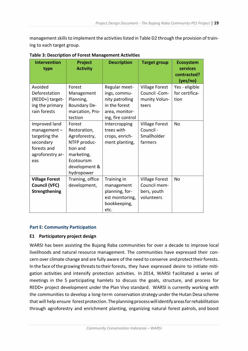
Project Design Document - The Bujang Raba Community PES Project | 19
Community Conservation Indonesia – WARSI
management skills to implement the activities listed in Table D2 through the provision of train-
ing to each target group.
Table 3: Description of Forest Management Activities
Intervention type
Project Activity
Description Target group Ecosystem services
contracted? (yes/no)
Avoided Deforestation (REDD+) target-ing the primary rain forests
Forest Management Planning, Boundary De-marcation, Pro-tection
Regular meet-ings, commu-nity patrolling in the forest area, monitor-ing, fire control
Village Forest Council -Com-munity Volun-teers
Yes - eligible for certifica-tion
Improved land management – targeting the secondary forests and agroforestry ar-eas
Forest Restoration, Agroforestry, NTFP produc-tion and marketing, Ecotourism development & hydropower
Intercropping trees with crops, enrich-ment planting,
Village Forest Council -Smallholder farmers
No
Village Forest Council (VFC) Strengthening
Training, office development,
Training in management planning, for-est monitoring, bookkeeping, etc.
Village Forest Council mem-bers, youth volunteers
No
Part E: Community Participation
E1 Participatory project design
WARSI has been assisting the Bujang Raba communities for over a decade to improve local
livelihoods and natural resource management. The communities have expressed their con-
cern over climate change and are fully aware of the need to conserve and protect their forests.
In the face of the growing threats to their forests, they have expressed desire to initiate miti-
gation activities and intensify protection activities. In 2014, WARSI f acilitated a series of
meetings in the 5 participating hamlets to discuss the goals, structure, and process for
REDD+ project development under the Plan Vivo standard. WARSI is currently working with
the communities to develop a long-term conservation strategy under the Hutan Desa scheme
that will help ensure forest protection. The planning process will identify areas for rehabilitation
through agroforestry and enrichment planting, organizing natural forest patrols, and boost
Project Design Document - The Bujang Raba Community PES Project | 20
Community Conservation Indonesia – WARSI
income from NTFPs. The project is also working with the communities to design a wildlife
corridor and scale-up renewable energy use to reduce firewood consumption. These consul-
tative and joint-planning activities are producing detailed plan vivos for each community under
a broader landscape-level master plan. This is an on-going process that will be updated as the
community gains experience. The detail program and activities are explained in the table be-
low:
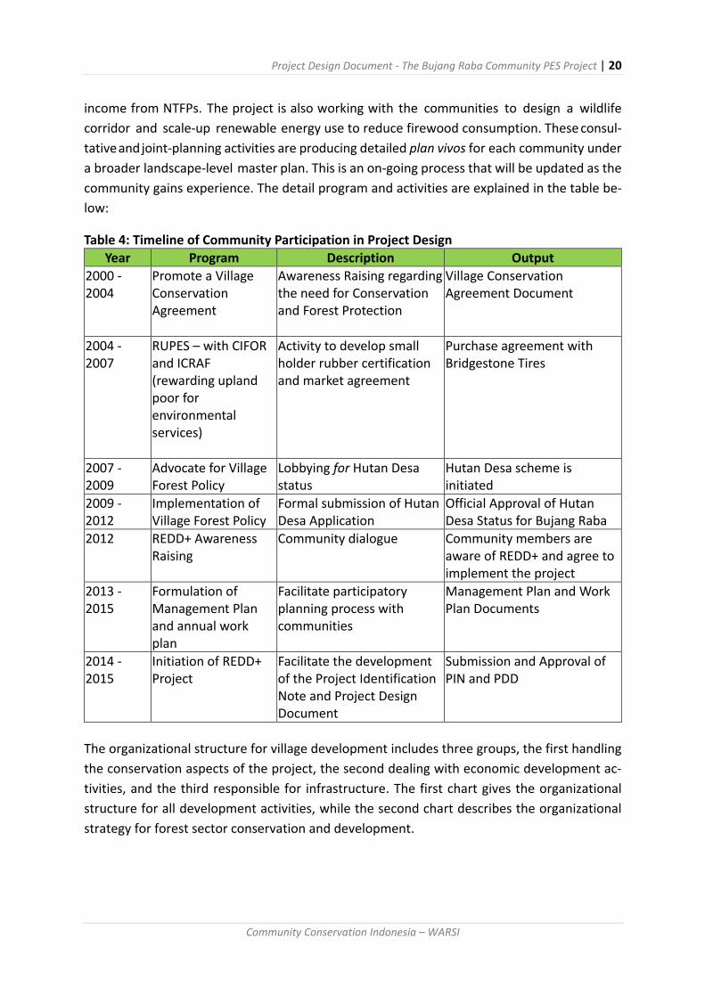
Table 4: Timeline of Community Participation in Project Design
Year Program Description Output
2000 - 2004
Promote a Village Conservation Agreement
Awareness Raising regarding the need for Conservation and Forest Protection
Village Conservation Agreement Document
2004 - 2007
RUPES – with CIFOR and ICRAF (rewarding upland poor for environmental services)
Activity to develop small holder rubber certification and market agreement
Purchase agreement with Bridgestone Tires
2007 - 2009
Advocate for Village Forest Policy
Lobbying for Hutan Desa status
Hutan Desa scheme is initiated
2009 - 2012
Implementation of Village Forest Policy
Formal submission of Hutan Desa Application
Official Approval of Hutan Desa Status for Bujang Raba
2012 REDD+ Awareness Raising
Community dialogue Community members are aware of REDD+ and agree to implement the project
2013 - 2015
Formulation of Management Plan and annual work plan
Facilitate participatory planning process with communities
Management Plan and Work Plan Documents
2014 - 2015
Initiation of REDD+ Project
Facilitate the development of the Project Identification Note and Project Design Document
Submission and Approval of PIN and PDD
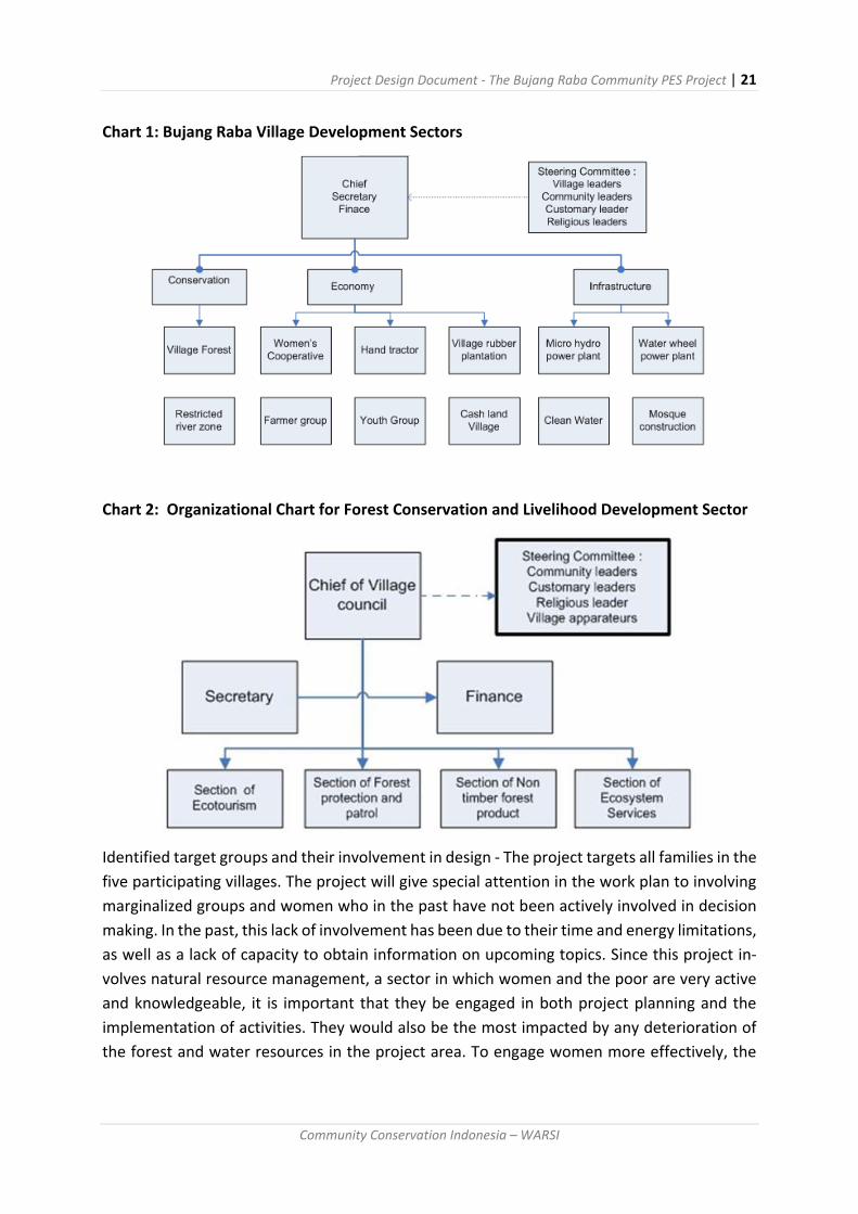
The organizational structure for village development includes three groups, the first handling
the conservation aspects of the project, the second dealing with economic development ac-
tivities, and the third responsible for infrastructure. The first chart gives the organizational
structure for all development activities, while the second chart describes the organizational
strategy for forest sector conservation and development.
Project Design Document - The Bujang Raba Community PES Project | 21
Community Conservation Indonesia – WARSI
Chart 1: Bujang Raba Village Development Sectors
Chart 2: Organizational Chart for Forest Conservation and Livelihood Development Sector
Identified target groups and their involvement in design - The project targets all families in the
five participating villages. The project will give special attention in the work plan to involving
marginalized groups and women who in the past have not been actively involved in decision
making. In the past, this lack of involvement has been due to their time and energy limitations,
as well as a lack of capacity to obtain information on upcoming topics. Since this project in-
volves natural resource management, a sector in which women and the poor are very active
and knowledgeable, it is important that they be engaged in both project planning and the
implementation of activities. They would also be the most impacted by any deterioration of
the forest and water resources in the project area. To engage women more effectively, the

Project Design Document - The Bujang Raba Community PES Project | 22
Community Conservation Indonesia – WARSI
project will work with the Women’s Cooperative (Koperasi Dahlia), which has already demon-
strated a capacity to improve the economic status of its members. While the Cooperative was
formed as a savings and loan association for its members, it is also engaged in organizing wed-
dings, leasing, and an educational savings program. Low-income members of the community
would be given priority in economic livelihood activities.
There is also a cooperative labour society (gotong royong) for agricultural activities, a water
wheel user group that is now producing electricity, and a chicken-sharing association that pro-
duces poultry for traditional ceremonies. Newer institutions include a micro-hydropower
user association, a women’s handicraft group, and a tree nursery that raises seedlings for
agroforestry (dragon’s blood, agar wood, cocoa, cardamom, rubber, and other crops). Local
women have also formed a number of cooperatives (koperasi Dahlia) with assets valued at
approximately $100,000. Institutional capacity has developed with WARSI’s support, with
trainings seeking to develop skills for forest protection, restoration, and monitoring. Training
programs have also benefited production of women’s handicrafts. The potential for eco-tour-
ism in the area is very high due to the pristine nature of the old growth forests and the rich
mega-fauna in the area. New skills for eco-tourism management will be included in the pro-
ject.
E2 Community-led implementation
The Village Forest Council has been working with the Customary Forest Councils in 2014 to
develop a management plan for the conservation forest (hutan lindung) that is the project
area. The village forest management plans are classified into four main activities: Village forest
management plans, village forest business plans, institutional capacity and lastly capacity
building for human resources. The local government through the forestry service has approved
these main programs. The VFC meets with the CFC and all community members to review the
management plan and agree to its implementation. Any concerns are raised and discussed at
that time. The following pictures illustrate the active roles community members played in
designing the project, conducting PRAs to identify key management issues, and in measuring
forest plots to establish the project baseline.
E3 Community-level project governance
With the support of the WARSI team, Village Forest Communication Forum will hold monthly
meetings with representatives from the village forest councils in 5 villages and representative
of customary forest councils to discuss management plan implementation, including forest
protection and restoration activities, livelihood enterprises, and monitoring and reporting
tasks. At the beginning of each year the recommendation Village forest Forum will be
implemented in each village forest council. All members will approve the management plan
after discussions and any revisions. At the end of the year, after monitoring data is collected,
the Village Forest Communication Forum will prepare an annual project report and present it
to the participants. The community participants will then agree to approve the report, which

Project Design Document - The Bujang Raba Community PES Project | 23
Community Conservation Indonesia – WARSI
will be submitted to Plan Vivo.
Figure 1: Community Project Planning Meeting
Figure 2: PRA Mapping Exercise
Grievance and grievance recording system - Usually, a complaint is raised within the commu-
nity and discussed (Ota di Pelantah). If it is not resolved by the neighbourhood, it is taken to
meeting of the elder uncles who traditional act as community arbitrators. In most cases, the
dispute is resolved at that level, however, if the parties fail to reach an agreement, the con-
flict is taken to the sub-district (Kecamatan) government.
Project Design Document - The Bujang Raba Community PES Project | 24
Community Conservation Indonesia – WARSI
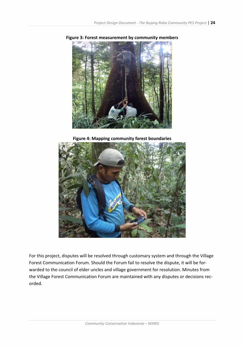
Figure 3: Forest measurement by community members
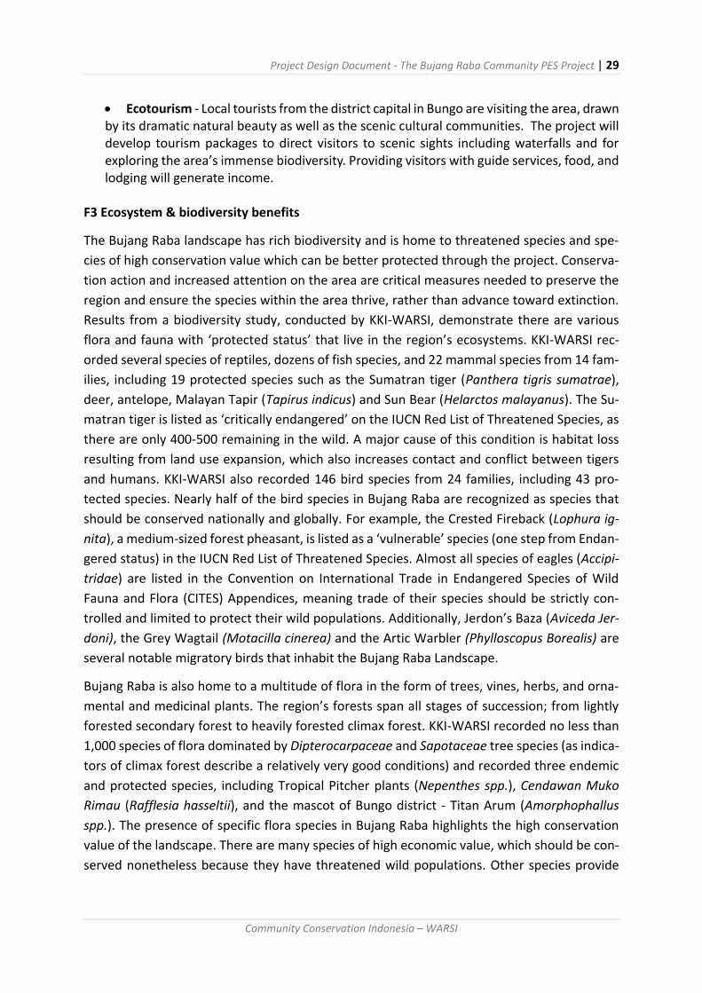
Figure 4: Mapping community forest boundaries
For this project, disputes will be resolved through customary system and through the Village
Forest Communication Forum. Should the Forum fail to resolve the dispute, it will be for-
warded to the council of elder uncles and village government for resolution. Minutes from
the Village Forest Communication Forum are maintained with any disputes or decisions rec-
orded.

Project Design Document - The Bujang Raba Community PES Project | 25
Community Conservation Indonesia – WARSI
Part F: Ecosystem Services & Other Project Benefits
F1 Potential Carbon Benefits
This proposed Plan Vivo project will cover an area of 7,291 ha of which the REDD+ project
component will be located in the 5,336 ha conservation zone comprised of primary tropical
lowland forest. The remaining 1,955 ha of secondary forests will be managed sustainable as
an agroforestry production area and will not seek carbon credits at this time. KKI WARSI has
analysed deforestation in the Bujang Raba landscape between 1993 and 2013 and found that
the rate of forest loss was 1.6% per year. Based on the forest plot inventories, in the 5,336 ha.
Primary forest which forms the area for the REDD+ project where ground average carbon
stocks are 287 tC/ha or 1,052 tCO2eq/ha. In contrast, forest plot inventories determined that
when the primary forest is converted to rubber agroforests or secondary growth of 15 years
of more the average above ground carbon was 59 tC/ha or 217 tCO2e. As a consequence, by
not converting the primary forests under the ‘with project’ scenario there is a net benefit of
228 tC/ha.
After extensive discussions with the five participating communities, they agreed to reduce
emissions by 75% per year by cutting forest loss. This assumption is based on a community
agreement to protect their village forest (hutan desa) that evolved during project discussions
with the WARSI team from 2006 and led to first approval of a Hutan Desa (HD) agreement in
Indonesia in 2009. Over that period, the rate of deforestation in the project area declined to
0.4%, or 82% reduction against the baseline rate of 1.6 % in the larger reference area (Bujang
Raba Landscape).
Based on this assumption, over the next 10 years the Bujang Raba Community PES project
would reduce emissions by 379,101 tCO2eq. Detail of the calculations are presented in Form
F1, as follow:
Without the project, the pattern of deforestation in the project will continue as a result as
community members require forest land for short term cultivation of rain-fed rice and for
longer term use as agroforestry rubber gardens. This process of natural forest conversion
includes tree felling, after which the slash is left to dry and then burned to clear the area for
planting. Rain-fed rice and vegetables, including chilies, legumes and eggplant, are planted and
are harvested through the first year. During the second year, if the farmer has some capital,
they will usually plant rubber and fruit trees such as durian, duku, and rambutan. The farmer
will care for the gardens during the third and fourth year to ensure the survival of the rubber
trees, and then leave it until the rubber can be harvested sometime in the 8th to 10th year. By
the fifteenth year the rubber agroforestry garden is producing rubber, some timber, and a
variety of fruit.

Project Design Document - The Bujang Raba Community PES Project | 26
Community Conservation Indonesia – WARSI
Chart 3: Succession Pattern in Deforested Areas
If farmers have limited capital, they will not care for the rubber trees after planting and the
productivity of the garden will suffer. For farmers with no capital, after the rained rice harvest
they will abandon the plot, which will transition, to scrub and eventually secondary forest over
a period of 15 years, however they will often plant some bananas or other fruit tree to indicate
their ownership of the field. In some cases, rubber agroforests also revert to secondary forests
if farmers lack capital and skills to manage them. Improving the management of these
production systems by integrating other commercially valuable crops and better stewardship
of rubber production will reduce the need for extensive forest conversion.
The total above ground carbon stock in the primary forests in the project area was 287 tC/ha
or 1,053 tCO2. The average above ground carbon stock in the secondary forest and rubber
agroforestry plots of 15 years age or more was 59 tC/ha or 217 tCO2/ha. At a rate of 1.6 % per
year, under the without project scenario, 85 ha of forest would be converted to rubber
agroforestry gardens or scrub and secondary forests each year. As a consequence, each
hectare of primary forest that would be converted to rubber agroforestry or secondary forests
would lose approximately 836 tCO2/ha, or 71,439 tCO2 for the entire project in year 1 (see
Table 5). Assuming the project can reduce the loss by 75%, emissions in the first year would
be lowered by 53,579 tCO2 (net carbon benefit 40,720 tCO2e).
Natural succession
Forest
Felled and Burned
Rubber Planting Shrub
Rubber Agro-forestry
Cultivation/intervention
Secondary Forest
Paddy

Project Design Document - The Bujang Raba Community PES Project | 27
Community Conservation Indonesia – WARSI
Table 5: Potential Carbon Emissions Reductions in village forest Bujang Raba
Year
to
Year Baseline
carbon up-
take i.e.
without
project
Carbon
emissions
with pro-
ject (75%)
Potential
Carbon
Emissions
Reduc-
tions
Potential
leakage
(5%)
Total Carbon
Benefit
(after leak-
age deduc-
tion)
Deduc-
tion of
20% risk
buffer
Net
carbon ben-
efit
(tCO2eq) (tCO2eq) (tCO2eq) (tCO2eq) (tCO2eq) (tCO2eq) (tCO2eq)
0 2013 0 0 0 - 0 - -
1 2014 71,439 17,860 53,579 2,679 50,900 10,180 40,720
2 2015 70,296 17,574 52,722 2,636 50,086 10,017 40,069
3 2016 69,171 17,293 51,879 2,594 49,285 9,857 39,428
4 2017 68,065 17,016 51,049 2,552 48,496 9,699 38,797
5 2018 66,976 16,744 50,232 2,512 47,720 9,544 38,176
6 2019 65,904 16,476 49,428 2,471 46,957 9,391 37,565
7 2020 64,850 16,212 48,637 2,432 46,205 9,241 36,964
8 2021 63,812 15,953 47,859 2,393 45,466 9,093 36,373
9 2022 62,791 15,698 47,093 2,355 44,739 8,948 35,791
10 2023 61,786 15,447 46,340 2,317 44,023 8,805 35,218
Total 665,090 166,273 498,818 24,941 473,877 94,775 379,101
Annual
average 66,509 16,627 49,882 2,494 47,388 9,478 37,910
F2 Livelihoods benefits
The project will not have negative impacts on livelihood benefits. Table F2 identifies some of
the benefits from REDD+, which will improve management of conservation forest areas re-
sulting in improved environmental services and financial flows from carbon offset payments.
This will help develop the eco-tourism program that is under design. The project will also im-
prove agroforestry systems through better commodity development, processing and market-
ing linkages.

Project Design Document - The Bujang Raba Community PES Project | 28
Community Conservation Indonesia – WARSI
Table 6: Livelihoods benefits
Food and agricul-tural pro-duction
Financial assets and in-comes
Environ-mental services (water soil etc.)
Energy Timber & non-tim-ber forest products (incl. for-est food)
Land & tenure se-curity
Use-rights to natural resources
Social and cul-tural assets
Primary Forest Conserva-tion
Potential revenues from REDD+
Important for water delivery and soil conserva-tion
Stabilizing hydrology results in better source of hydro-power
Source of NTFP and some subsist-ence tim-ber for housing
Strong Adat rights re-spected by local govern-ment
Community forestry manage-ment agree-ment – Vil-lage Forest
High value an-cestral domain claim – deep lo-cal knowledge of ecosystems
Agrofor-estry
Important source of subsist-ence food and ma-terials
Slows run-off and en-courage infiltra-tion
Fuelwood Important source of timber and NTFP
Allocated by com-munity
Household rights
Traditional prac-tices
Wet Rice Agricul-ture
Highly produc-tive source of stable food
Efficient use of water for irrigation returns to river
Rice husks
Limited timber re-sources
Privately owned
Privately owned
Traditional prac-tices
Rubber Gardens
Gener-ates cash income for health care, edu-cational and other needs
Slows run-off and en-courages infiltra-tion
Fuel wood
Important source of timber
Privately owned
Privately owned
New component in 20th century
To continue to achieve the target of 75% reduction in deforestation rates a number of initia-
tives that will be implemented as part of the with project scenario including:
Land use intensification - One of the main income sources in the communities are agroforestry rubber gardens. Income from rubber will be supplemented through the introduction and intensification of high value crops such as cardamom, cocoa, and other NTFPs that can be integrated into the smallholder agroforestry plots.
Improve NTFP processing - The project will work with community members to build bamboo and rattan processing capacities. Both products are abundant in the village forest areas.
Project Design Document - The Bujang Raba Community PES Project | 29
Community Conservation Indonesia – WARSI
Ecotourism - Local tourists from the district capital in Bungo are visiting the area, drawn by its dramatic natural beauty as well as the scenic cultural communities. The project will develop tourism packages to direct visitors to scenic sights including waterfalls and for exploring the area’s immense biodiversity. Providing visitors with guide services, food, and lodging will generate income.
F3 Ecosystem & biodiversity benefits
The Bujang Raba landscape has rich biodiversity and is home to threatened species and spe-
cies of high conservation value which can be better protected through the project. Conserva-
tion action and increased attention on the area are critical measures needed to preserve the
region and ensure the species within the area thrive, rather than advance toward extinction.
Results from a biodiversity study, conducted by KKI-WARSI, demonstrate there are various
flora and fauna with ‘protected status’ that live in the region’s ecosystems. KKI-WARSI rec-
orded several species of reptiles, dozens of fish species, and 22 mammal species from 14 fam-
ilies, including 19 protected species such as the Sumatran tiger (Panthera tigris sumatrae),
deer, antelope, Malayan Tapir (Tapirus indicus) and Sun Bear (Helarctos malayanus). The Su-
matran tiger is listed as ‘critically endangered’ on the IUCN Red List of Threatened Species, as
there are only 400-500 remaining in the wild. A major cause of this condition is habitat loss
resulting from land use expansion, which also increases contact and conflict between tigers
and humans. KKI-WARSI also recorded 146 bird species from 24 families, including 43 pro-
tected species. Nearly half of the bird species in Bujang Raba are recognized as species that
should be conserved nationally and globally. For example, the Crested Fireback (Lophura ig-
nita), a medium-sized forest pheasant, is listed as a ‘vulnerable’ species (one step from Endan-
gered status) in the IUCN Red List of Threatened Species. Almost all species of eagles (Accipi-
tridae) are listed in the Convention on International Trade in Endangered Species of Wild
Fauna and Flora (CITES) Appendices, meaning trade of their species should be strictly con-
trolled and limited to protect their wild populations. Additionally, Jerdon’s Baza (Aviceda Jer-
doni), the Grey Wagtail (Motacilla cinerea) and the Artic Warbler (Phylloscopus Borealis) are
several notable migratory birds that inhabit the Bujang Raba Landscape.
Bujang Raba is also home to a multitude of flora in the form of trees, vines, herbs, and orna-
mental and medicinal plants. The region’s forests span all stages of succession; from lightly
forested secondary forest to heavily forested climax forest. KKI-WARSI recorded no less than
1,000 species of flora dominated by Dipterocarpaceae and Sapotaceae tree species (as indica-
tors of climax forest describe a relatively very good conditions) and recorded three endemic
and protected species, including Tropical Pitcher plants (Nepenthes spp.), Cendawan Muko
Rimau (Rafflesia hasseltii), and the mascot of Bungo district - Titan Arum (Amorphophallus
spp.). The presence of specific flora species in Bujang Raba highlights the high conservation
value of the landscape. There are many species of high economic value, which should be con-
served nonetheless because they have threatened wild populations. Other species provide

Project Design Document - The Bujang Raba Community PES Project | 30
Community Conservation Indonesia – WARSI
local communities with construction materials, ropes, food, and traditional medicines. Two
iconic botanic species, Amorphophallus and Rafflesia are also found in Bujang Raba. Their
presence is notable, especially of the Rafflesia, because they are usually found only in forests
that are still in good condition.
The project would not have any negative impact on the forest area. The project will increase
the capacity of the newly formed Village Forest Council and the customary forest council to
both protect habitat and monitor changes in biodiversity through community reporting on the
siting of key indicator species, including tiger, bear, deer, and hornbill. Improved habitat pro-
tection, controlling poaching, and monitoring should increase the population of critical biodi-
versity. Protection from logging and forest conversion should also improve endemic plant pop-
ulations. The impact of the project on biodiversity will be monitored using local indicators
include the tracks and scat of wild animals, bird songs, small deer (Kancil) populations, and
abundance of river fish. In the past, logging and forest conversion have resulted in substantial
increases in erosion. Forest loss has also influenced climate change causing a hotter microcli-
mate. The project seeks to stabilize soils and mitigate local climate changes through forest
protection. Monitoring systems to track environmental changes are discussed in Part K.
Table 7: Ecosystem Impacts
Intervention type (tech-nical specifica-tion)
Biodiversity im-pacts
Water and watershed impacts
Soil productiv-ity/ conservation impacts
Other impacts
REDD+ Improve habitat quality and quan-tity – place re-strictions on hunt-ing of endangered species and estab-lish monitoring system to track changes in popula-tions
Improve aq-uifer re-charge and stream flows
Reduce soil ero-sion and stream sedimentation
Reduce carbon loss

Project Design Document - The Bujang Raba Community PES Project | 31
Community Conservation Indonesia – WARSI
Part G: Technical Specifications
G1 Project Intervention and activities
The project seeks to reduce deforestation and forest degradation (REDD) in 5,336 ha of pri-
mary tropical lowland forest in the Bukit Barisan Mountain range of Jambi Province, Indonesia.
The forests are the customary lands of the indigenous Jambi tribe who are under pressure
from a growing population that requires forest lands for farming, fuel, and other services, as
well as private sector interests that seek to exploit the natural forest lands for timber, mining,
and conversion to estate crops. The forest rights of the communities have been recognized by
the Government of Indonesia under the village forest (hutan desa) program, giving them ten-
ure authority to manage the project forests for 35 years, with options to renew.
The five participating villages have agreed to protect and manage the project area, while using
income from carbon sales to develop high value agroforestry systems on the community sec-
ondary forestland. The situation is well suited for a Plan Vivo project as it conforms to the
standards by supporting forest conservation and restoration through community action, while
providing additional biodiversity conservation, hydrological and socio-economic benefits.
Without a project, it is likely that the forests would continue to be depleted at the current
rate. The five participating communities will implement the proposed project with technical
support from WARSI and the Indonesian Community PES Consortium. The project is a long-
term initiative designed to conserve natural resources and enhance household livelihoods and
the quality of life within the communities on a sustainable basis.
G2 Additionality and Environmental Integrity
Initial estimates indicate that forest loss in the surrounding district has occurred at a rate of 1.6
percent per year over the past decade. Without the project it is estimated that the project area
would lose hundreds of hectares of primary lowland tropical forest and emit over three million
tons of C02. As a result of the project, forest loss and emissions will be reduced by approxi-
mately 75%.
WARSI has been working with the local and national government over the past decade to
strengthen the rights of the project communities over their customary forestlands. With the
issuance of Hutan Desa status for the project area in 2013, project communities now possess
legal rights to manage the area. Part C, section 3 describes the legal arrangements that secure
tenure in the project area. While the area has been zoned a Protection Forest by the Govern-
ment of Indonesia for some time, this has not resulted in a halt to forest loss in the project
area. Only through a well planned and executed forest management strategy, like that pro-
posed under the Plan Vivo standards, is it likely that the forest can be effectively conserved.
The communities’ capacity to protect forests in the project area is confronted by a number of
barriers that would frustrate efforts to conserve that high value ecosystem in the absence of

Project Design Document - The Bujang Raba Community PES Project | 32
Community Conservation Indonesia – WARSI
a well-designed strategy. Examples of some of the constraints to sustainable forest manage-
ment are listed below. The project team is discussing each constraint to identify ways they can
be removed or reduced through project activities.
Table 8: Project Barriers and Barrier Mitigation Actions
Type of Bar-rier
Description of Barrier Overcoming Barrier
Financial/ economic bar-riers
Lack of funds to support
patrolling, fire control, biodi-
versity conservation activities
and monitoring.
Funds from carbon sales will support annual work plan and activities
Technical bar-riers
Community institutions lack the skills and communica-tion capacity to mobilize public opinion and interact with local government.
Lack of experience in de-
veloping management plans,
mapping boundaries, and using
monitoring equipment.
WARSI team will help the Village Forest Forum to estab-lish a project office and train their management team
Training and cross-visits in planning, mapping and moni-toring are underway
Institutional/ political barri-ers
Community lacks political influence to address threats from coal mining and palm oil companies
Community needs to strengthen relations with Dis-trict Government leadership
WARSI has organized joint meetings with local govern-ment leaders to help the com-munities build communication channels and contacts in gov-ernment
Ecological barriers
Project area includes very steep terrain with limited ac-cess through foot paths
A network of forest rest houses are planned for patrols and eco-tourists, trails will be improved
Logistical bar-riers
Road linkages to District capital restrict eco-tourism de-velopment and the flow of ser-vices from government pro-grams.
Networking with govern-ment agencies should increase visitors and investments in roads
Cultural barri-ers
Language and cultural bar-riers between the community and outside assistance agen-cies limit access to technical and financial support
WARSI and the Consor-tium are providing linkages to national and international or-ganizations.
The project is fully independent and not derived from legislative action or projects from
other sources. It is not part of a broader economic development scheme. Hutan Desa

Project Design Document - The Bujang Raba Community PES Project | 33
Community Conservation Indonesia – WARSI
status is an important signifier of local control over forest management, but threats to the
village forest remain potent. From within, livelihood insecurity can diminish the effectiveness
of conservation activities if locals must turn to extraction for income. Exogenous threats such
as incursion by illegal loggers is another major issue. Financial benefits from Plan Vivo certif-
icate sales will ensure that local people have the resources to fully protect their traditional forest
area, preparing and implementing management plans that meet Plan Vivo standards.
G3 Project Period
The project start date is January 2014. While WARSI has been working with the project com-
munities for over ten years, the initiation of the REDD+ project in Bujang Raba started in 2012,
during the process the local community is interested to apply PES carbon project in January
2014. This included the start of the participatory planning process for REDD+ mitigation activ-
ities, the acquisition of remotely sensed images of the area and the beginning of analysis and
preparation of baseline scenarios.
The project proposes that the crediting period and quantification be carried out for 10 years
under the REDD+ activities. This will likely be extended in the future as the community is com-
mitted to sustaining the project forest as a conservation area (hutan lindung) in perpetuity
G4 Baseline Scenario
G4.1 Trend Deforestation in Project area
KKI WARSI has analyzed deforestation in project area from 2006 to 2013 by using Satelite
Lansat, based on our analysis the trend of deforestation in project area is 0.4% per year or
with the total forest loss is 157 hectares.
Map 4: Forest Cover in Village Forest Bujang Raba
G4.2 Carbon pools
Project Design Document - The Bujang Raba Community PES Project | 34
Community Conservation Indonesia – WARSI
The project seeks to measure and quantify only above and below ground biomass from woody
species. The project will also estimate the below ground carbon as a percentage of the tree
biomass. Other carbon pools would be expensive to measure and the project will have insig-
nificant impact on them, so they will not be quantified and monitored.
Table 9: Project Carbon Pools
Carbon Pool Likely impact of project on C-stock
Limitations Decision to include in calculations
Above ground woody biomass
High Can be assessed using GFW data- requires GIS skills.
Included
Below ground woody biomass
Moderate Difficult to measure, but can be assessed as proportion of AGB. – Not likely to change
Not Included
Soil Low Difficult to measure – Not significant
Not Included
Leaf litter Low Difficult to measure – Not significant
Not Included
Dead wood Low Difficult to measure – Not significant
Not Included
Non-tree bio-mass
Low Difficult to measure – Not significant
Not Included
Other
G4.3 Baseline Methodology (Reference Area)
The project has selected a 42,422 ha landscape in the upper watershed of Bungo District as
the reference area, which is referred to as the Bujang Raba Landscape. The area included in
the reference area for Bujang Raba only includes classified conservation and production forest
areas (based on Letters of Decision by the Ministry of Forestry No. 727-II/2012 dated 10 De-
cember 2012) see Table 10.
Table 10. Forest Classifications in the Reference Area
No Forest Area Hectares %
1 Protected Forest 13,293 31%
2 Production Forest 29,129 69%
Grand Total 42,422 100%

Project Design Document - The Bujang Raba Community PES Project | 35
Community Conservation Indonesia – WARSI
Map 5. Map of Forest Area in Reference Area
The Reference Area was selected to represent four forests management units (FMU) that are
present around the project area and that are shaping forest cover and land use change in the
area. The largest are the Production Forest representing 67% of the reference area and the
smallest being the customary forest covering 2% of the reference area.
The Bujang Raba Landscape Reference Area totals 42,422 ha or approximately 6 times the size
of the project area. The reference area was selected to represent dominant land use patterns
as well as geophysical conditions. There are four types of FMU in the reference area reflecting
patterns of forest conversion potentially impacting the project area.
Table 11: Forest management unit in Reference Area
No
Forest Concession
Area
Hectares %
1 Customary Forest 725 2%
2 Production Forests 28,403 67%
3 Protected Forests 5,800 13%
4 Village Forest 7,494 18%
Grand Total 42,422 100%
The Bujang Raba Landscape Reference Area closely approximates biophysical conditions pre-
sent in the project area and is approximately 6 times the size. An analysis of Landsat TM data
with a resolution of 30 m by the WARSI team was based on two data sets from 1993 and 2013.

Project Design Document - The Bujang Raba Community PES Project | 36
Community Conservation Indonesia – WARSI
Based on this assessment it was possible to determine that primary forest decreased from
39,611 ha in 1993 to 27,260 ha in 2013 representing a loss of 12,351 ha or 1.6% per year.
Primary drivers of forest loss included smallholder farmers converting forests to farmland as
well as from logging concessions expansion. The pattern of forest loss appeared to be accel-
erating as road access this remote part of Sumatra improves and as demand for forestland
conversion grows. Further, much of the deforestation in the past twenty years has occurred
on the eastern side of the reference area where the project is located due to its accessibility.
As a result, deforestation pressures in the project area maybe relatively higher than in other
parts of the reference area. Changes in forest cover in the Bujang Raba Landscape Reference
Area are shown below in Map 6.
In Indonesia, the Forest Land Use Consensus Plan (Tata Guna Hutan Kesepakatan) was estab-
lished in 1982. This land use plan classified 75 per cent (or 144 million hectares) of Indonesia’s
land as forest areas. When TGHK was established indigenous rights (adat and hak ulayat) re-
ceived little recognition in Sumatra. After the end of the Suharto era, increasing authority was
given to District (Kabupaten) Government over land allocation, with some communities re-
ceiving forest management rights (hutan desa). While national, provincial and district govern-
ments are engaged in land use planning and zoning, its impact on the ground has only partial
influence on actual land use behavior, especially in reference to forest loss.
In Jambi, communities traditionally viewed forests as “tanah with no lord” (tanah tak bertuan).
Any member of the community requiring the resource for farming or settlement could clear
unclaimed, natural forest. This traditional practice remains active in many parts of rural Jambi
and South Sumatra. Unoccupied forests are viewed as a land reserve to be drawn as needed.
For the most part, communities are completely unaware of the land status determined by the
government. Experience in the project area indicates that when they do learn of government
claims and attempt to gain greater information regarding forestland status, local government
officials are often similarly ignorant.
In Bungo District the primary determinant of future deforestation is often proximity to roads
and topographic access. The project area, relative to Bungo District, has greater road access
and in the past experienced a more rapid rate of deforestation than the district as a whole,
despite its designation as a protection forest. In contrast, there are neighboring production
forestlands that have experienced little forest loss due to their isolation. Prior to the initiation
of community forest conservation activities, the project area lost 1,955 ha of forest, which
was converted to farmlands by local villagers despite it being zoned protected forest by the
government. This represented a 27% decline in forest cover between 1999 and 2006, or an
annual loss of 3.9%. When we compare the annual rate of forest loss in the reference area at
1.6% during the reference period of 1993 to 2013, it reflects deforestation trends in Jambi
province and Bungo District as a whole. For example, Jambi Province experienced a 2.15%
annual loss of forest cover from 1990 to 2010. Bungo District lost 2.51% of its forest cover

Project Design Document - The Bujang Raba Community PES Project | 37
Community Conservation Indonesia – WARSI
each year from 2003 to 2006. Setting the baseline rate at 1.6% should be considered a con-
servative estimate, given the forest loss rate in the project area of 3.9%, prior to the initiation
of mitigation activities.
Map 6: Reference Area and Project Area in Bungo District
Map 7 shows the official land use categories under the RTRWP (Provincial Spatial Plan) and
the TGHK (Spatial plan for forest lands in Jambi). While the categories do not necessary reflect
how the lands will be used in the future or their relative risk of deforestation. Government
policies allow for changes in land allocation including the release of mining concessions in
protection forests. As such, the reference area provides a blend of land use categories adja-
cent to the project area and under threat from a diverse set of internal and external drivers
of deforestation. Without the project, it is assumed that forest loss in the project area would
reflect trends operating across the reference area.

Project Design Document - The Bujang Raba Community PES Project | 38
Community Conservation Indonesia – WARSI
Map 7: Forest management unit in Reference Area
In terms of slope in the reference region, like the project area, is dominated by moderately
steep slopes of 25-40%, which cover 64.8% of the reference area, with 33.8% of the area
greater than 40% incline. There is no slope in the reference of area that is less than 8%.
Table 12: Slope in the Reference Area
No
Slope
Area
Hectares %
1 > 40 % 14,357 33.8%
2 25 - 40 % 27,481 64.8%
3 8 - 15 % 584 1.4%
Grand Total 42,422 100%
Project Design Document - The Bujang Raba Community PES Project | 39
Community Conservation Indonesia – WARSI
Map 8: Slope in the Reference Area
Map 9: Forest Cover Change in Reference Area, 1993 to 2013
If the current pattern of forest loss continues the project area would lose approximately 795
ha over the next ten years, or 79 ha per year. Based on the project strategy to reduce the rate
of deforestation in the project area from the historical 1.6% by 75% to 0.55%, only approxi-
mately 20 ha per year would be lost. The table below estimate the amount of forest cover in
the project area over the next decade under with and without project scenario.

Project Design Document - The Bujang Raba Community PES Project | 40
Community Conservation Indonesia – WARSI
Table 13: Comparison of Deforestation under With and Without Project Scenarios
Year
to
Year Without Project (Base-
line/deforestation rate
1.6%)
With Project (emissions reduc-
tions by 75%)
Deforestation
can be Pre-
vented (ha)
Forest
cover (ha)
Deforestation
(ha/year)
Forest cover
(ha)
Deforestation
(ha/year)
0 2013 5,336 - 5,336 - 0.00
1 2014 5,251 85.38 5,315 21.34 64.03
2 2015 5,167 84.01 5,294 21.00 63.01
3 2016 5,084 82.67 5,273 20.67 62.00
4 2017 5,003 81.34 5,253 20.34 61.01
5 2018 4,923 80.04 5,233 20.01 60.03
6 2019 4,844 78.76 5,213 19.69 59.07
7 2020 4,766 77.50 5,194 19.38 58.13
8 2021 4,690 76.26 5,175 19.07 57.20
9 2022 4,615 75.04 5,156 18.76 56.28
10 2023 4,541 73.84 5,137 18.46 55.38
Total 795 199 596
Annual average 79 20 59.61
G4.4 Baseline Emission
In 2013, the project area of primary forest was 5,336 ha. Without the project it is estimated
that over the next ten years the area of primary forest would decrease to 4,541 ha. If the
project is implemented the primary forest would decrease to 5,137 ha and as a result 596 ha
would be saved from deforestation over the coming decade. Without the Project, it is esti-
mated that the above ground carbon stock in the primary forest would decreased to 4,781,841
tCO2, by 2023. With the project the carbon stock at that time would be 5,409,566 tCO2, reduc-
ing emissions by 498,818 tCO2. The figures above are based on assumptions that without the
project, loss of primary forest would continue at the historic reference area rate of 1.6% per
year through 2023 and that with the project this rate would be reduced by 75% to 0.55% per
year.
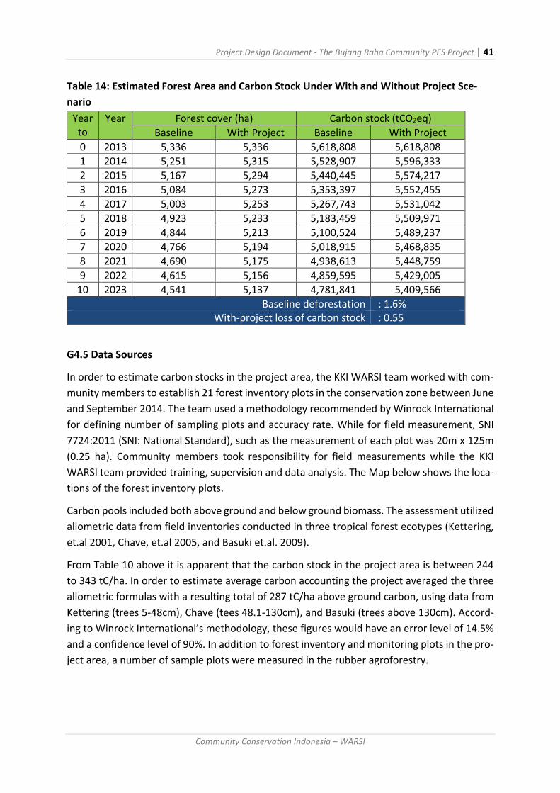
Project Design Document - The Bujang Raba Community PES Project | 41
Community Conservation Indonesia – WARSI
Table 14: Estimated Forest Area and Carbon Stock Under With and Without Project Sce-
nario
Year to
Year Forest cover (ha) Carbon stock (tCO2eq)
Baseline With Project Baseline With Project
0 2013 5,336 5,336 5,618,808 5,618,808
1 2014 5,251 5,315 5,528,907 5,596,333
2 2015 5,167 5,294 5,440,445 5,574,217
3 2016 5,084 5,273 5,353,397 5,552,455
4 2017 5,003 5,253 5,267,743 5,531,042
5 2018 4,923 5,233 5,183,459 5,509,971
6 2019 4,844 5,213 5,100,524 5,489,237
7 2020 4,766 5,194 5,018,915 5,468,835
8 2021 4,690 5,175 4,938,613 5,448,759
9 2022 4,615 5,156 4,859,595 5,429,005
10 2023 4,541 5,137 4,781,841 5,409,566
Baseline deforestation : 1.6% With-project loss of carbon stock : 0.55
G4.5 Data Sources
In order to estimate carbon stocks in the project area, the KKI WARSI team worked with com-
munity members to establish 21 forest inventory plots in the conservation zone between June
and September 2014. The team used a methodology recommended by Winrock International
for defining number of sampling plots and accuracy rate. While for field measurement, SNI
7724:2011 (SNI: National Standard), such as the measurement of each plot was 20m x 125m
(0.25 ha). Community members took responsibility for field measurements while the KKI
WARSI team provided training, supervision and data analysis. The Map below shows the loca-
tions of the forest inventory plots.
Carbon pools included both above ground and below ground biomass. The assessment utilized
allometric data from field inventories conducted in three tropical forest ecotypes (Kettering,
et.al 2001, Chave, et.al 2005, and Basuki et.al. 2009).
From Table 10 above it is apparent that the carbon stock in the project area is between 244
to 343 tC/ha. In order to estimate average carbon accounting the project averaged the three
allometric formulas with a resulting total of 287 tC/ha above ground carbon, using data from
Kettering (trees 5-48cm), Chave (tees 48.1-130cm), and Basuki (trees above 130cm). Accord-
ing to Winrock International’s methodology, these figures would have an error level of 14.5%
and a confidence level of 90%. In addition to forest inventory and monitoring plots in the pro-
ject area, a number of sample plots were measured in the rubber agroforestry.

Project Design Document - The Bujang Raba Community PES Project | 42
Community Conservation Indonesia – WARSI
Map 10: Distribution of Permanent Sampling plots in project area
Table 15: Carbon Stocks in Bujang Raba Forest Plot Inventory
No Plot
Kettering (2001), C-stock (ton/ha)
Chave (2005), C-stock (ton/ha)
Basuki (2009), C-stock (ton/ha)
Combination three allometrics, C-stock (ton/ha)
1 LB1 251 323 235 293
2 LB2 318 349 252 280
3 LB3 571 611 412 486
4 LB4 195 235 185 188
5 LB5 183 235 176 196
6 LB6 348 387 277 284
7 LB7 698 704 483 509
8 SL1 373 462 344 418
9 SL2 200 256 185 230
10 SL3 170 237 182 199
11 SM1 190 251 180 220
12 SM2 179 239 163 215
13 SM3 185 247 183 223
14 ST1 315 378 226 318
15 ST2 327 416 278 368
16 ST3 119 164 134 142
17 SU1 270 319 241 294
18 SU2 196 254 186 238
19 SU3 508 586 381 470
20 SU4 264 315 233 267
21 SU5 201 232 182 183
Average 288 343 244 287

Project Design Document - The Bujang Raba Community PES Project | 43
Community Conservation Indonesia – WARSI
Note : The code reflects the location of the sample plot within each of the five villages’ project areas (LB= Lubuk Beringin, SL= Sangi-Letung, SM= Sungai Mengkuang, ST=Sungai Telang, dan SU= Senamat Ulu).
Table 16: Carbon Stocks in Bujang Raba Rubber Agroforestry and Secondary Forest Plot In-
ventory
No Plot
Kettering (2001), C-stock (ton/ha)
Chave (2005), C-stock (ton/ha)
Basuki (2009), C-stock (ton/ha)
Combination three allometrics, C-stock (ton/ha)
1 LBRA1 75 110 104 77
2 LBRA2 84 111 129 97
3 LBRA3 55 80 79 55
4 LBSF1 30 44 53 30
5 LBSF2 36 52 63 36
Average 56 79 86 59
Note: The plot code indicates the location of the plot and the land use code LB= Lubuk Ber-ingin, RA= Rubber Agroforestry, and SF= Secondary Forest
For comparative purposes the team sampled five plots outside the forest including the rubber
agroforestry plots of more than 15 years and two plots of secondary forests 15 years or older.
In each of the agroforestry and secondary forest plots the carbon was calculated using same
three algometric equations, with the average.
G5 Ecosystem Service Benefits
The project expects to result in significant reductions in emissions between 2014 and 2023,
even after the deduction of a 20% buffer and potential leakage of 5%. The Baseline uptake
assumes that 85 hectares of forest would be lost in Year 1 declining to 73 ha in 2023, reflecting
a 1.6% annual decline in forest area. The project also assumes that each hectare of felled for-
est would be converted to rubber agroforestry or become degraded secondary forest. In the
transition primary forests with an average carbon stock of 1,053 tCO2, would be converted to
these alternate land uses with an estimate carbon stock of 217tCO2/ha. This would result in a
net loss of 836 tCO2/ha with emissions of 71,439 tCO2 in Year 1 (2014) without the project.
With the project emissions would be reduced by 75% to an estimated 17,844 tCO2. With the
deduction of the 20% risk buffer net carbon benefit in 2014 would be 40,720 tCO2, and
379,101 tCO2 over the initial ten year first of the project

Project Design Document - The Bujang Raba Community PES Project | 44
Community Conservation Indonesia – WARSI
Table 17: Expected Emissions Reductions
Year
to
Year Baseline
carbon
uptake
i.e. with-
out pro-
ject
Carbon
emis-
sions
with pro-
ject
(75%)
Potential
Carbon
Emis-
sions Re-
ductions
Potential
leakage
(5%)
Total Carbon
Benefit (af-
ter leakage
deduction)
Deduction
of 20% risk
buffer
Net car-
bon ben-
efit
(tCO2eq) (tCO2eq) (tCO2eq) (tCO2eq) (tCO2eq) (tCO2eq) (tCO2eq)
0 2013 0 0 0 - 0 - -
1 2014 71,439 17,860 53,579 2,679 50,900 10,180 40,720
2 2015 70,296 17,574 52,722 2,636 50,086 10,017 40,069
3 2016 69,171 17,293 51,879 2,594 49,285 9,857 39,428
4 2017 68,065 17,016 51,049 2,552 48,496 9,699 38,797
5 2018 66,976 16,744 50,232 2,512 47,720 9,544 38,176
6 2019 65,904 16,476 49,428 2,471 46,957 9,391 37,565
7 2020 64,850 16,212 48,637 2,432 46,205 9,241 36,964
8 2021 63,812 15,953 47,859 2,393 45,466 9,093 36,373
9 2022 62,791 15,698 47,093 2,355 44,739 8,948 35,791
10 2023 61,786 15,447 46,340 2,317 44,023 8,805 35,218
Total 665,090 166,273 498,818 24,941 473,877 94,775 379,101
Annual
average 66,509 16,627 49,882 2,494 47,388 9,478 37,910

Project Design Document - The Bujang Raba Community PES Project | 45
Community Conservation Indonesia – WARSI
G6 Leakage and Uncertainty
Primary sources of potential leakages involve new families who require house lots and agro-
forestry land to support their household. Approximately 25 new families will arise each year
in the project communities with each allotted 1 hectare of land. The project area is included
within the larger ancestral lands that have traditionally been relied on as the land pool. Leak-
age from the project area is estimated to most likely occur within 1 km of the southern project
boundary in the protected forest. The leakage belt will be monitored by patrol as well as the
leakage assessed after five year through the analysis of satellite imagery.
The problem of transferring pressures from the project area to other areas outside the project
was discussed with the community. The community felt that it was unlikely this would occur,
as there is adequate land in the utilization zone (secondary forest) for more intensive agrofor-
estry production. The project anticipates that the 25 hectares of land required each year can
be sourced from abandoned fields and secondary forest outside the project area’s primary
forest zone. This land will not only be able to provide any additional dry farming land as well
as land for fruit gardens and mixed rubber forests. According to the KKI WARSI survey and
intensive discussions with the community members the potential for leakage in the next five
years was minimal and less than 1%. To be conservative, a 5% loss from leakage has been
estimated for the initial project period, which will be revised after 5 years. In addition, the
abandoned field and secondary forests have a lower carbon stock of around 30tC/ha, which
could be increased to 100 tC/ha after conversion to a well-managed agroforestry plot. In ad-
dition, the risk buffer has been set at 20% to ensure any leakage is accounted for.
Map 11. Leakage Belt Area

Project Design Document - The Bujang Raba Community PES Project | 46
Community Conservation Indonesia – WARSI
Part H: Risk Management
The project developers used a VCS method for estimating the risk buffer. Based on these
calculations, the risk buffer was set at 20%, with a 14% internal risk factor, a 1% external risk
factor, with no natural risk factor. The internal risk rate includes 12% for project longevity, 2%
for project management, and 1% for financial viability and opportunity costs. The external risk
rate was based on 1% for resource tenure, and 3% for community engagement and political
risk. Natural risk causes such as forest fire, pest and disease outbreaks, extreme weather and
geological risk where rated at 1%, as there has been no incidence of deforestation in the pro-
ject area related to those causes. While forest fires occasionally occur around new agricultural
sites and pest outbreaks arise on agricultural lands, these have not impacted the project for-
ests in the past. Deforestation, when it does occur, is largely due to changes in land use.
The table below identifies a range of internal and external risks that the project faces. While
some risks exist at low to moderate levels, the project will not encounter any high-risk prob-
lems moving forward.
Table 18: Bujang Raba Project Risk Analysis
Type of Risk
and Level
Description of Specific Risks How Risks will be overcome by
project activities
External - Fi-
nancial/ eco-
nomic risk
Moderate
Insufficient financial re-
sources to develop project
Problems finding buy-
ers for Carbon
Funding secured to de-
velop initial project, on-going
project management and
transaction costs and pay-
ments for ecosystem services
Project works with Con-
sortium and brokers to de-
velop national Indonesia
Community PES Project brand
and market network
Internal -
Technical risks
Moderate
Project coordinator or-
ganisation does not currently
have required skill set and
human resources necessary
to implement and manage
the project
Recruitment of staff and
skill strengthening for the
project coordinator
Training undertaken
with the project coordinator
staff, site coordinators and
community field workers in-

Project Design Document - The Bujang Raba Community PES Project | 47
Community Conservation Indonesia – WARSI
Communities without
awareness and skills to initi-
ate project development
processes and activities.
clude mapping; biomass in-
ventories; participatory
threat assessment
External -
Political risks
Low to
Moderate
Lack of regulation re-
garding forestry and land-
use, or poor enforcement of
such regulations.
Collaboration and com-
munication with district gov-
ernment will minimize these
barriers. At this time, com-
munication with local govern-
ment has been started, they
support this program as one
of development program for
green development
Natural -
Environmental
risks
Low
Soil degradation and
landslide, natural events
such as drought and forest
fire
The project intervention
through forest management
plans will minimize the eco-
logical barriers. For the last
10 years, the ecological risks
have been low
Internal -
Social risks
Low
Poor organisation and
mobilisation of local commu-
nities and groups, remote-
ness of communities
The role of steering/board member will be strengthening to make sure the village council will be well performed.
Regular meeting is conducted to make sure the remoteness of communities will be able to participate
Internal -
Cultural risks
Low
Traditional knowledge,
laws and customs, market
conditions or practices, tradi-
tional equipment and man-
agement activities
Most of traditional knowledge/wisdom area is oriented on conservation. So, it may not be a barriers on this project implementation
Considering that the risk analysis and leakage assessment indicate relatively low-level risk and
leakage the project developers suggest setting the buffer at 20%. Given the strong consensus
among community members to protect the primary forest and develop the secondary forest
for sustainable agroforestry and considering the relative abundance of natural resources in
the area this level of reserve should be adequate for the proposed project.

Project Design Document - The Bujang Raba Community PES Project | 48
Community Conservation Indonesia – WARSI
Once the buffer is deducted the project should generate climate benefits of approximately
37,910 tCO2 each year for the next ten years (see table 17). At $4 to $5 per tCO2 this would
yield between $130,000 and $160,000 annually if all certificates are sold, sufficient revenues
to sustain the proposed project and annual work plans.
Part I: Project Coordination & Management
WARSI offers extensive experience with community development and natural resource
management projects. WARSI’s staff includes technical specialists in GIS, remote sensing,
forest inventory, and socio-economic and livelihood development. WARSI also retains ex-
cellent relationships with local and national government agencies, allowing it to act as
an effective intermediary in resolving resource conflicts. We are also pleased to facilitate the
work of students and researchers from Indonesia and abroad.
I1 Project Organizational Structure
KKI WARSI will act as the project coordinator for the Bujang Raba PES Project, representing a
regional NGO with two decades of experience with community development and conservation
projects. With a staff composition of 76 persons, WARIS possesses staff expertise to calculate
and monitor forest carbon stocks and manage a GIS database as well as to conduct field sup-
port operations. Under this project KKI WARSI will work with the community through the Vil-
lage Forest Forum to implement the management plan for Bujang Raba Village Forest. This
will include the process of monitoring and verifying outcomes. The organizational structure
for the project is presented in the diagram below
Chart 4: Project Organizational Management Structure
Table 19: Participating Organizations in the Bujang Raba Community PES Project
Organization Experience Capacity
WARSI Regional NGO with extensive experi-ence in community development project management as well as with the project communities
Experience field staff that can as-sist communities to build project management capacities including design, implementation and re-porting

Project Design Document - The Bujang Raba Community PES Project | 49
Community Conservation Indonesia – WARSI
Village Forest Forum
Newly established umbrella organi-zation to coordinate the project ac-tivities of the five villages
Develop a community-based pro-ject management capacity
Village Forest Council
Five newly established organizations responsible for Hutan Desa area (Primary Forest inside project area)
Authority, local knowledge -
Customary Forest Council
Five traditional community forest management organizations respon-sible for customary forest area (out-side project area)
Authority, local knowledge
Consortium (Kemitraan, LATIN, Kpshk, CFI, etc.)
National and international organiza-tions familiar with REDD+ project development
Skills to provide technical support and financial assistance in the de-velopment of the project
I2 Relationships to national organizations
WARSI works closely with the provincial, district, and sub-district governments in order to co-
ordinate activities and communicate progress. WARSI is also in communications with the na-
tional REDD+ Agency and the Ministry of Forestry. WARSI seeks to provide the national REDD+
Agency with learning regarding their experiences with sub national REDD+ project design.
There are no major government projects in the REDD+ project area at this time.
I3 Legal compliance
The community is already certified as a Hutan Desa under Indonesian law and has the
approval of the relevant bodies to participate in this program. WARSI is an equal opportunity
employer. WARSI is a registered non-governmental, non-profit organization that operates in
full compliance with Indonesian law.
I4 Project Management
The NGO WARSI will act as Project Developer and has appointed Emmy Primadona as Project
Manager to act under the direction of the WARSI Executive Director. The WARSI project team
includes: the project manager, business manager, project accountant, forest activity coordi-
nator, socio-economic activity coordinator, and monitoring and reporting specialist (see An-
nex 1). WARSI will be responsible for assisting the Village Forest Forum with communications
and technical support including interactions with Plan Vivo, Markit Registry, participating bro-
kers and buyers. WARSI will also provide assistance with monitoring and the preparation of
the annual report.

Project Design Document - The Bujang Raba Community PES Project | 50
Community Conservation Indonesia – WARSI
Table 20: Work Plan Timeline for 2014-2016
Month and Year Activity
January 2014 Community REDD+ Planning Dialogue Initiated
February-May 2014 Development of PIN – Bali Workshop Preparation of Baseline Data and Analysis
June-October Community Consultation for Project Design
November Drafting of PDD and Review
April 2015 PDD Approval - Community Monitoring of project im-pacts
May Validation Visit
June Submission of Annual Report for 2014
March-December Certification and Marketing of 2014 certificates
January-December Implementation of 2015 Work Plan
January 2016 Monitoring and Preparation of 2015 Annual Report
The WARSI team will work with the Village Forest Forum and each Village Forest Council to
develop a record keeping system. The system will document the following items:
Financial income and expenditures
Minutes of all Village Forest Council Meetings
Reports from the Forest Patrols
Environmental and Socio-Economic monitoring indicators
In addition to collecting the data above, the joint WARSI/Village Forest Council team will be
responsible for preparing the annual report and submitting it to Plan Vivo.
I5 Project financial management
WARSI will be responsible for managing all carbon revenues and other PES income, depositing
all funds in a special project account. WARSI has estimated project costs for the 2015-2016
period (see Table 20) based on the activity plan outlined in this document. WARSI will disburse
funds through the network of Village Forest Councils in coordination with the Village Forest
Forum.
The disbursement process includes the following steps:
Carbon revenues are received and allocated to the general mitigation activities described in Section D.
Each Village Forest Council will submit a work plan after consultation with village members.
The Village Forest Forum will assess the plans according to overall strategy and priority.
Based on the Village Forest Forum recommendations, WARSI will advance funds to each Village Forest Council.
During implementation WARSI: and the Forest Forum will conduct a monitoring exercise.
Based on the results of the monitoring and assuming the communities have met their

Project Design Document - The Bujang Raba Community PES Project | 51
Community Conservation Indonesia – WARSI
emission reduction targets, WARSI will provide the balance of the project budget due to each Village Forest Council.
If there is a problem in activity, the matter will be discussed with the steering committee comprised of the village headman, adat, and religious leaders.
Chart 5: Fund Distribution Channel
I6 Marketing
WARSI is working with other Consortium members to develop a national marketing strategy
guided through the Consortium secretariat. This joint groups is exploring potential sales to
European organizations (Fair Climate Fund, We Forest, U and WE, etc.), as well as to Indonesia
CPR buyers. WARSI is working with a media firm (Yayasan Perspektip Baru) to develop mar-
keting materials, including short films. WARSI will also work with the Consortium members
and participate in a PES Marketplace event in the spring of 2015 to present the project to CPR
buyers in Indonesia.
Carbon Fund
Project Developer
VFF for:
1. Avoided Deforestation
2. Livelihood Activities
3. Strengthening Institutions
4. Social fund
VFC
Sungai
Mengkuang
VFC
Sungai
Mengkuang
VFC
Sungai
Mengkuang
VFC
Sungai
Mengkuang
VFC
Sungai
Mengkuang
Monitoring Channel
Fund Distribution Channel
Project Design Document - The Bujang Raba Community PES Project | 52
Community Conservation Indonesia – WARSI
I7 Technical Support
WARSI will seek technical support from the Consortium, CFI, FFI and other agencies within
Indonesia as needed during the implementation of the project. We are currently assessing
institutions that might serve as a validator and will consult with Plan Vivo to finalize our
choice. WARSI is the project developer and will take the lead role in all interactions with Plan
Vivo and other partners over the next five years, during which time it intends to promote
self-determination among the participating communities regarding management responsibil-
ity.
WARSI was first established in December 1991 as a network agency using the name Yayasan
Warung Informasi Konservasi (The Conservation Information Foundation) – abbreviated
fondly as “WARSI.” It was created through the efforts of 12 NGOs in four provinces in southern
Sumatra (West Sumatra, Jambi, Bengkulu, and South Sumatra) to address mutual concern
about natural resource management and community empowerment.
In July 2002, the WARSI Foundation became its own fully-fledged non- profit organization
known as Komunitas Konservasi Indonesia (The Indonesian Conservation Community) or KKI
WARSI. Located in Jambi, the organization is currently working all over Indonesia. Taking “Con-
servation with Community” as its motto, KKI WARSI supports development that fulfils present
needs without harming the livelihoods of the future.
Our staff roster includes 76 people working at both our central office in Jambi city as well as
field offices in towns across Jambi and West Sumatra. WARSI receives support from major bi-
lateral donors and foundations and enjoys an excellent reputation as an organization that
develops high quality projects with communities.
In moving forward with this project, WARSI has received guidance from Community Forestry
International (CFI) regarding their experience with Plan Vivo standards, procedures, and
marketing. Our staff are currently working closely with CFI and Fauna and Flora International
(FFI) to develop MRV systems that meet the Plan Vivo requirements. In addition, Badan Pengel-
ola REDD+ Indonesia is currently supporting NGO-led demonstration activities with funding
through its FREDDI (Funds for REDD Indonesia) initiative, with a focus on scaling up successful
models.
Due to WARSI’s extensive experience supporting community development over the past 23
years, we are confident that we can meaningfully engage communities in the design and imple-
mentation of this REDD+/PES project. WARSI’s technical staff will assist these communities
in developing of carbon and other environmental and socio-economic baseline data and
monitoring systems. We are currently developing a financial management and benefit sharing
system for revenue generated by Plan Vivo certificates.

Project Design Document - The Bujang Raba Community PES Project | 53
Community Conservation Indonesia – WARSI
Part J: Benefit Sharing
J1 PES agreements
WARSI has been conducting a series of meetings in all five villages over the past year to raise
awareness about the REDD project. The meetings allow community members to raise ques-
tions about the project and discuss whether they wish to be a part of the REDD+ initiative.
After repeated meetings, there is a consensus among the community and its leaders that con-
serving the primary forests and participating in the Plan Vivo project is desirable. The obliga-
tions of the WARSI, the Village Forest Councils, and the participating households have been
discussed at length and have been accepted by the communities. In Annex1 an agreement
document is included.
J2 Payments & Benefit Sharing
The Bujang Raba project is a community-wide effort with all households participating. Income
from the sales of Plan Vivo certificates will be used for projects that benefit the entire com-
munity (i.e. drinking water, micro-hydro, schools, health care delivery, etc.). Payments are
dependent on the successful implementation of the annual work plan and the delivery of an
acceptable annual report to Plan Vivo by the management team. Benefits will be allocated
according to the annual budget. If additional resources are available, the Village Forest Coun-
cils and the Management Team will discuss distribution to encourage livelihood activities to
special community groups (women’s micro finance- Koperasi Dahlia, Farmer’s Clubs, student
groups, etc.). The annual work plan and budget will be developed and reviewed by the Village
Forest Councils and project management team (WARSI) to ensure equity and transparency by
all stakeholders.
The project seeks to reward the five communities with at least 60% of the carbon revenues,
with the remaining 40% or less going to WARSI to act as project developer and manager.
Funds received by WARSI will be used to cover staff costs for project administration, as well
as training, extension, awareness raising activities, monitoring, and reporting. In 2014-2015,
WARSI costs for the above activities were $79,220 (see Annex 2b), however those costs in-
cluded PDD development costs including forest inventory that will not be needed annually.
The WARSI funds will also be used to handle the transaction costs for marketing and pro-
cessing carbon sales, bank fees, and related costs. The projected costs for 2015-2016 for com-
munity support is $116,000 (see Annex 2a). Basic project operational costs will have first draw
on carbon revenues and once fully funded, additional funds will be allocated for distribution
to the five participating communities, with the share reflecting the relative size of the forest
under their management. WARSI anticipates project revenues will be approximately $200,000
per year, provided that the net additional carbon benefit of approximately 40,000 tCO2 can be
sold at an average price of $5 per tCO2.

Project Design Document - The Bujang Raba Community PES Project | 54
Community Conservation Indonesia – WARSI
After project management and implementation costs are cover, any additional funds will be
given to the community after the completion of each year’s work plan and a collaborative
assessment of the “state of the forest,” examining the indicators shown above. The presence
of indicators of forest cover change, including land cleared for agriculture, illegal logging, fire,
etc., that show the community has fallen into the yellow zone will result in a 50% reduction in
benefit payments. Full payments will be reinstated once the community demonstrates that
they have reduced for loss to within the Green Zone parameter for their forest. The payment
will take place at the end of the calendar year.
WARSI will be responsible for managing the project database. This will include keeping records
of all carbon sales including volumes, prices, and value in US dollars and Indonesian Rupiah.
The project will also maintain a database of all payment to communities from carbon sales
(see Annex 4a and 4b). The database will be used to report to the VFC during quarterly meet-
ings, and in the preparation of the annual report to Plan Vivo. All Plan Vivo certificates will be
held in the project Market Registry account with issuance requests submitted at the time of
sale to Plan Vivo
Part K: Monitoring
Under the project monitoring plan WARSI and the participating communities will assess the
impact of forest loss mitigation activities as reflected in the Plan Vivo standard. The system
for monitoring carbon stocks in the project intervention area forms only one part of the overall
monitoring plan for the project (as required by the Plan Vivo standard). Other tracking indica-
tors include the socio-economic monitoring, biodiversity monitoring, monitoring other envi-
ronmental services and monitoring the drivers of deforestation.
In accordance with the Plan Vivo standard the technical specification will be reviewed after 5
years. The data produced as part of the project monitoring system will contribute to improving
and refining the technical specifications. The monitoring data gathered on a quarterly and
annual basis will be archived both at the project office in the village as well as by WARSI to
ensure that important data do not become lost.
K1 Ecosystem services benefits
Indicators that will be used to monitor the climate benefits of project activities are summa-
rized in the Table 24. Key indicators of climate benefits will be reflected in changes in forest
habitat including forest fires impacts (total burned area each dry season), unauthorized log-
ging (total number of trees felled each year without community approval), and number of
hectares cleared for agriculture. These indicators will be updated every 2 months. Different
members of the community will collect the data with the results discussed at periodic meet-
ings of the Village Forest Council.

Project Design Document - The Bujang Raba Community PES Project | 55
Community Conservation Indonesia – WARSI
Table 21: Forest Cover Change and Carbon Monitoring
Indicator How it will be monitored
Who will monitor it
Fre-quency
Comments
Forest area (intact forest in the project intervention area)
Remote sens-ing
Project coordina-tor
After 5 years
Landsat TM data for 2013 and 2018 will be used.
Forest carbon stock
Reassessment of permanent plots com-bined with re-mote sensing
Project coordina-tor with commu-nity
After 5 years
Used to revise forest carbon stock data and re-vise the technical specification for this inter-vention (control of un-planned deforestation)
Forest condition
Fixed point photography in sample plots of from distant viewpoint
Project coordina-tor with commu-nity
Annually From fixed locations lo-cated by GPS
Drivers of defor-estation
During patrol-ling and during visits to sam-ple plots
Commu-nity (pa-trol teams)
Quar-terly
Record evidence of illicit tree felling, encroachment, fires etc. from sample plots and from regular forest pa-trols
The monitoring methodology is conducted as following methods:
Fixed Point Photo Monitoring - the project will establish a series of fixed-point photo moni-
toring locations throughout project area and community rubber agroforestry and agricultural
lands. Each point will provide an appropriate perspective of the forest to accommodate
growth and change over time. The photos will be taken twice annually and be kept in the
project office for inclusion in the annual report.
Satellite Monitoring - WARSI will assist the community in monitoring carbon stocks in the
project year by analysing the Landsat TM data with a resolution of 30 m every five years. The
WARSI team baseline utilized two data sets from 1993 and 2013. Additional images will be
acquired and analysed in 2018 and 2023 to assess the rate of forest cover change in the project
area as well as the reference area. If the five-year assessment indicates that forest loss ex-
ceeds the projected “green level” figures, the project team will meet with the community to
address the drivers and how to mitigate them more effectively. If it is determined that the
original technical specifications did not accurately estimate the baseline rate of forest loss or
that other miscalculations in the technical specifications were made, WARSI will work with
Plan Vivo to update the technical specifications and re-set the baseline and additionality cal-
culations.

Project Design Document - The Bujang Raba Community PES Project | 56
Community Conservation Indonesia – WARSI
Forest Patrol Monitoring - Quarterly forest patrols will monitor the following indicators:
Forest clearing and other disturbances will be identified, photographed, with an estimate of the area impacted and number of trees felled. Records will be kept for each event including identifying involved parties, and any fines or sanctions levied.
Illegal felling will be identified, photographed, and with an estimate of the area impacted and number of trees felled. The monitors will also estimate the amount of trees revolved.
Forest fires will be monitored and controlled. Dry season reports on fire incidences including the total area burned and source of the fire will be kept in the project office and utilized to track changes over time and the effectiveness of the fire control activities.
Poaching and biodiversity monitoring will be a key part of the forest patrol duties including inspecting for animal traps or other signs of poaching. The project will also monitor key indicator species and record observations of red-listed mammals (Sumatran tiger, honey bear, Simiang, and hornbills)
Landslides, wind throws, floods and other events related to possible changes in forest cover will be monitored by the patrol and the causes of these occurrences investigated.
These quarterly reports to the Village Forest Councils and Village Forest Forum will be sum-
marized in the annual report.
Forest Plot Monitoring - The project has established 21 forest monitoring plots located within
the protected forest area that represents the REDD+ components of this project. Additional
plots are located in the secondary forest area that is being developed for agroforestry. Forest
plots are 20x125 m in size (0.25ha) and are located along transect lines. Each of the five Hutan
Desa areas in the project possesses 3 to 6 plots each representing all micro-watersheds in the
project area. The project provides data on changes in forest condition, carbon stocks, as well
as biodiversity.
The goal is to reduce the rate of deforestation from the baseline 1.6 % per year to 0.55% per
year over the previous five-year period. Annual thresholds and targets for reducing deforesta-
tion are described in Table 22. If the target rate or more after five years achieves the reduced
rate of deforestation, the project will achieve “green” status. If the reduced rate of deforesta-
tion in the project area is less than the target, but more than the baseline the project will
achieve an “amber” status in which case the project developer will need to work with the
Village Forest Forum members to discuss how the drivers of deforestation can be better con-
trolled. If the reduced rate of deforestation is the same or greater than the reference area,
the project will receive a “red” status and will have demonstrated no “additionality.” At the
point the project may either be re-designed or halted. Data from the satellite images after
five years of protection, combined with data for the forest plot inventory will allow the project
developers and communities to recalculate changes in carbon stock and revise estimates for

Project Design Document - The Bujang Raba Community PES Project | 57
Community Conservation Indonesia – WARSI
emission reduction over the next five years. Table 22 describes the thresholds and targets for
project performance monitoring based on total of deforestation occurring in each of the five
project community forests.
Table 22: Annual Thresholds and Targets for Project Performance Monitoring based on total of deforestation
Threshold Achievement Level
Village Forest Council
Total area
Green Level - if the local people are able to reduce
emissions by 75%
Yellow Level - if the local people are able to reduce emissions from 25% until 75%
Red Level - if the local community are only able to
reduce emissions < 25%
Sangi - Letung 736 < 0.55 ha From 0.55 – 1.63 ha > 1.63 ha
Sungai Mengkuang
634 < 0.48 ha From0.48 – 1.41ha
> 1.41 ha
Senamat Ulu 1,095 < 0.82 ha From 0.82 – 2.44 ha > 2.44 ha
Sungai Telang 745 < 0.56 ha From 0.56 – 1.65 ha > 1.65 ha
Lubuk Beringin 2,126 < 1.59 ha From 1.59 – 4.72 ha > 4.72 ha
Threshold Range
5,336 ha < 3.95 ha More than 3.95 ha &
less than 11.85 ha > 11.85
Benefit Allocation 100% 50% 0%
The carbon benefit from carbon sales will be distributed proportionally based on the perfor-
mance each of the Village Forest and organized by the Village Forest Forum. The threshold
ranges is described in Table 23.
Table 23: Benefit by Village When Threshold Target is achieved 2014-2023
No Village Forest Area (protection
zone)
Net Carbon
Benefit/ Village
Forest (ton
CO2eq)
Target project
performance
base on defor-
estation (ha) Hectares %
1 Sangi - Letung 736 14% 52,290 8.22
2 Sungai Mengkuang 634 12% 45,043 7.08
3 Senamat Ulu 1,095 21% 77,795 12.23
4 Sungai Telang 745 14% 52,929 8.32
5 Lubuk Beringin 2,126 40% 151,044 23.75
Grand Total 5,336 100% 379,101 59.61

Project Design Document - The Bujang Raba Community PES Project | 58
Community Conservation Indonesia – WARSI
Table 22 shows the annual thresholds and target for the project performance each of the vil-
lage based on indicative colour. The colour is as a guideline for local community to monitor
deforestation level. This table is also used for distribution payment. The payment will be dis-
tributed proportionally based on total project area each of the village. When one of the vil-
lages does not meet the requirement of the thresholds range, let’s say colour red, they will
not get the reward while the other 4 villages that still keep the commitment to control defor-
estation will get the payment based on the threshold range.
K2 Socio-economic monitoring plans and impacts
WARSI is conducting a baseline socio-economic study of households to document annual in-
come levels at the beginning of the project. Cash assets of the women’s enterprise groups
(Koperasi Wanita) will be monitoring quarterly to assess progress in building capital. The pro-
ject will also monitor the numbers of people receiving health care and social services with
special emphasis on low-income households, the PES expenditures of stakeholder groups and
their conformity with management plans and PES agreements, and the number and type of
management problems faced by the community and resolution strategies. These indicators
will be reported on annually. The socio-economic survey will be completed every five years to
track changes. WARSI staff and members of the five participating communities will conduct
household interviews. Results from the survey will be presented to each Village Forest Council,
the Village Government, and the Village Forest Forum and be used to discuss priority liveli-
hood activities for the next annual work plan.
The Socio-Economic monitoring plan focuses on women’s enterprise indicators such as capital
assets in the micro-finance accounts. It also monitors community participation in village meet-
ings, and access of low-income families to medical services. A household survey is conducted
every five years to assess changes in household assets and income. These are reflected in the
“Well-being” indicators including condition of houses, access to electricity, sanitary facilities,
and land ownership. The socioeconomic monitoring plan and potential wellbeing indicators
are summarized in Tables 24 and 25.
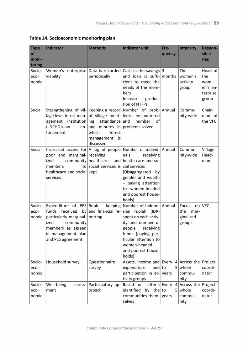
Project Design Document - The Bujang Raba Community PES Project | 59
Community Conservation Indonesia – WARSI
Table 24. Socioeconomic monitoring plan
Type of moni-toring
Indicator Methods Indicator unit Fre-quency
Intensity Respon-sibili-ties
Socio-eco-nomic
Women’s enterprise viability
Data is recorded periodically
Cash in the savings and loan is suffi-cient to meet the needs of the mem-bers Increase produc-tion of NTFPs
3 months
The women’s activity group
Head of the wom-en's en-terprise group
Social Strengthening of vil-lage level forest man-agement institution (LDPHD)/law en-forcement
Keeping a record of village meet-ing attendance and minutes in which forest management is discussed
Number of prob-lems encountered and number of problems solved
Annual Commu-nity-wide
Chair-man of the VFC
Social Increased access for poor and marginal-ized community members to healthcare and social services
A log of people receiving healthcare and social services is kept
Number of individ-uals receiving health care and so-cial services (Disaggregated by gender and wealth – paying attention to women-headed and poorest house-holds)
Annual Commu-nity-wide
Village Head-man
Socio-eco-nomic
Expenditure of PES funds received by particularly marginal-ized community members as agreed in management plan and PES agreement
Book keeping and financial re-porting
Number of Indone-sian rupiah (IDR) spent on each activ-ity and number of people receiving funds (paying par-ticular attention to women-headed and poorest house-holds)
Annual Focus on the mar-ginalized groups
VFC
Socio-eco-nomic
Household survey Questionnaire survey
Assets, income and expenditure and participation in ac-tivity groups
Every 4 to 5 years
Across the whole commu-nity
Project coordi-nator
Socio-eco-nomic
Well-being assess-ment
Participatory ap-proach
Based on criteria identified by the communities them-selves
Every 4 to 5 years
Across the whole commu-nity
Project coordi-nator

Project Design Document - The Bujang Raba Community PES Project | 60
Community Conservation Indonesia – WARSI
Table 25. Examples of well-being indicators that may be used as part of the socio-economic
monitoring plan
Criteria Poor Medium Rich
House
Walls
Support
posts
Roof
Floor
House Size
Rooms
Bamboo
Unmilled timber
Leaves
Dirt or bamboo
4x6 m
1 bedroom and
kitchen
Rough Cement
Milled timber
Tin sheeting
Milled timber or ce-
ment
6x9 m
2-3 bedrooms and
kitchen
Refined Cement
Milled timber/cement
Tile
6x12.
3-4 bedrooms, kitchen, living
room 1-2 story
Electricity Oil lamp and illegal
electrical hook-up
Electrical supply
900w-1300w.
Electrical supply 2000w. With
back-up generator
Electronics & Vehicles Radio, TV, motor cycle
Refrigerator, washing ma-
chine, motorcycle, car. Flat
screen TV
Land ownership <3ha/ household 3-10 ha/ household 10+ha per household
Agroforestry gardens <1 ha 1-5 ha >5 ha
Work Day labourer,
farmer
Company employee,
teacher, civil serv-
ant, farmers
Company manager, govern-
ment officials, middleman,
farmer
Income <Rp 1 million Rp 1 to 10 million > Rp 10 million
Sanitation facilities No bathroom or
toilet
Simple Bathroom
and toilet
(no tile)
Tiled bathroom and toilet
In addition to the baseline survey and socio-economic monitoring system, as WARSI has been
working with the communities to address socio-economic needs for nearly a decade it has
complimentary monitoring systems to track changes in the women’s finance group (Koperasi
Dahlia), the community micro-hydro electrical generation project, and the agroforestry devel-
opment project. The existing monitoring system will continue to track changes and impacts
of these activities.
Special focus groups will be organized around the target groups including the 1) agroforestry
activity groups, 2) women’s micro-finance group, and 3) forest patrol and forest user group.
They will be responsible for discussing priority activities, providing input into the annual work
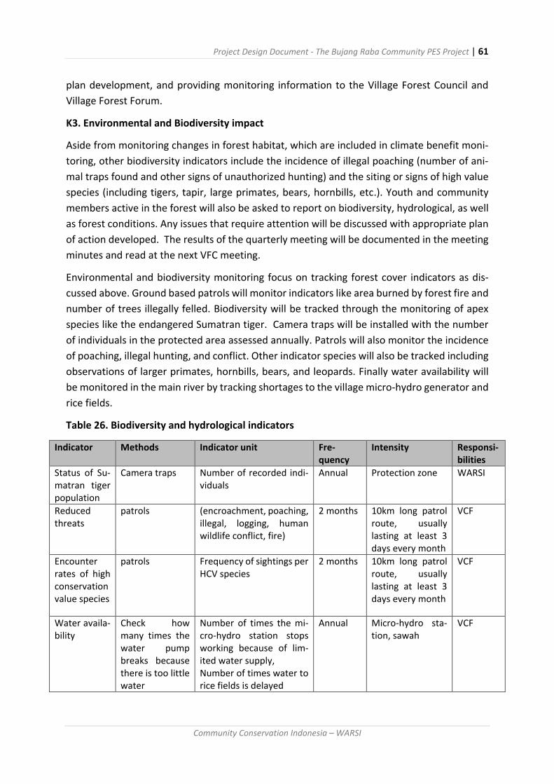
Project Design Document - The Bujang Raba Community PES Project | 61
Community Conservation Indonesia – WARSI
plan development, and providing monitoring information to the Village Forest Council and
Village Forest Forum.
K3. Environmental and Biodiversity impact
Aside from monitoring changes in forest habitat, which are included in climate benefit moni-
toring, other biodiversity indicators include the incidence of illegal poaching (number of ani-
mal traps found and other signs of unauthorized hunting) and the siting or signs of high value
species (including tigers, tapir, large primates, bears, hornbills, etc.). Youth and community
members active in the forest will also be asked to report on biodiversity, hydrological, as well
as forest conditions. Any issues that require attention will be discussed with appropriate plan
of action developed. The results of the quarterly meeting will be documented in the meeting
minutes and read at the next VFC meeting.
Environmental and biodiversity monitoring focus on tracking forest cover indicators as dis-
cussed above. Ground based patrols will monitor indicators like area burned by forest fire and
number of trees illegally felled. Biodiversity will be tracked through the monitoring of apex
species like the endangered Sumatran tiger. Camera traps will be installed with the number
of individuals in the protected area assessed annually. Patrols will also monitor the incidence
of poaching, illegal hunting, and conflict. Other indicator species will also be tracked including
observations of larger primates, hornbills, bears, and leopards. Finally water availability will
be monitored in the main river by tracking shortages to the village micro-hydro generator and
rice fields.
Table 26. Biodiversity and hydrological indicators
Indicator Methods Indicator unit Fre-quency
Intensity Responsi-bilities
Status of Su-matran tiger population
Camera traps Number of recorded indi-viduals
Annual Protection zone WARSI
Reduced threats
patrols (encroachment, poaching, illegal, logging, human wildlife conflict, fire)
2 months 10km long patrol route, usually lasting at least 3 days every month
VCF
Encounter rates of high conservation value species
patrols Frequency of sightings per HCV species
2 months 10km long patrol route, usually lasting at least 3 days every month
VCF
Water availa-bility
Check how many times the water pump breaks because there is too little water
Number of times the mi-cro-hydro station stops working because of lim-ited water supply, Number of times water to rice fields is delayed
Annual Micro-hydro sta-tion, sawah
VCF

Project Design Document - The Bujang Raba Community PES Project | 62
Community Conservation Indonesia – WARSI
K5 Other monitoring
A key to the success of the project is the capacity and activity levels of the Village Forest Coun-
cils as the lead community organization for project planning and implementation. The VFCs
have four scheduled annual meetings, plus additional meetings as needed. As project devel-
oper, WARSI will monitor their progress and provide capacity building in coordination with the
umbrella organization, the Village Forest Forum. The minutes of the Quarterly meetings
should provide one indicator regarding both the function and activities of the VFC and will be
used for institutional monitoring. In addition, each year each VFC will work with the VFF to
prepare an annual work plan and budget for their forest area. This document will also be an
important indicator of planning capacity and priorities. At the end of each year, the VFC will
need to make an annual report to the VFF and WARSI summarizing their achievements. WARSI
will work with the VFF to summarize the activities of the five participating VFC and submit
them to Plan Vivo at the end of each year.

Project Design Document - The Bujang Raba Community PES Project | 63
Community Conservation Indonesia – WARSI
References
Adnan H, Tadjudin D, Yuliani EL, Komarudin H, Lopulalan D, Siagian YL. 2008. Belajar dari Bungo: Mengelola Sumberdaya Alam di Era Desentralisasi. CIFOR. Bogor, Indonesia.
Anonim. 2006. Plot Quantity – Aboveground Carbon. Winrock International. http://www.winrock.org
Anonim. 2012. Laporan Akhir Rencana Tata Ruang Wilayah Propinsi Jambi tahun 2013 – 2033. Badan Perencanaan Pembangunan Daerah Propinsi Jambi.
Basuki TM, van Laake PE, Skidmore AK, Hussin YA. 2009. Allometric equations for estimat-ing the above-ground biomass in tropical lowland Dipterocarp forests. Forest Ecology and Management 257: 1684–1694.
Chave J, Andalo C, Brown S, Cairns MA, Chambers JQ, Eamus D, Folster H, Fromard F, Higu-chi N, Kira T, Lescure JP, Nelson BW, Ogawa H, Puig H, Riera B and Yamakura T. 2005. Tree allometry and improved estimation of carbon stocks and balance in tropical forests. Oecologia 145:87-99. DOI 10.1007/s00442- 005-0100-x.
Hairiah K, Ekadinata A, Sari RR, Rahayu S. 2011. Pengukuran Cadangan Karbon : dari tingkat lahan ke bentang lahan. Petunjuk praktis. Edisi kedua. Bogor, World Agroforestry Center, ICRAF SEA Regional Office, University of Brawijaya (UB), Malang, Indonesia xx p.
Ketterings QM, Coe R, van Norwijk M, Ambagau Y and Palm C. 2001. Reducing uncer-tainty in the use of allometric biomass equations for predicting above- ground tree biomass in mixed secondary forest. Forest Ecology and Management. 146: 199–209.
Kurniawan. 2014. Mengukur cadangan harbon hutan bujang Raba. http://www.ham-
paran.net/index.php/news-even/artikel/18-mengukur- cadangan-karbon-hutan-bu-
jang-raba
Standar Nasional Indonesia (SNI). 2011. Perhitungan dan pengukuran cadangan karbon
– Pengukuran lapangan untuk penaksiaran cadangan karbon hutan (ground base forest
carbon accounting). SNI 7724:2011. Badan Standarisasi Nasional. Jakarta, Indonesia.
SPECIAL REPORT: Palm oil, politics, and land use in Sumatra (Part II) Satria Eka Hadinaryanto,
Andi Fachrizal, Jogi Sirait, and Aji Wihardandi: Mongabay-Indonesia, April 26, 2014
Read more at http://news.mongabay.com/2014/0426-hadinaryanto-
jambi.html#JRspbCKAQdqeD8gD.99

Project Design Document - The Bujang Raba Community PES Project | 64
Community Conservation Indonesia – WARSI
Annex 1: List of Key people involved with contact information
Title Name Email Mobile Number
Project Manager: Emmy Pri-madona
[email protected] +62 812 1894 2211
Project Business Manager for Carbon Sales:
Fredi Yusuf [email protected] +62 813 6715 2381
Project Accountant: Retty Fistiana [email protected] +62 813 6673 1100
Forest Activity Coor-dinator
Miswandi [email protected] +62 821 7510 5609
Socio-Economic Ac-tivity Coordinator
Dinaldi [email protected] +62 813 6314 2898
Monitoring and Re-porting Person:
Lenni Permata Sari
+62 852 6344 0118
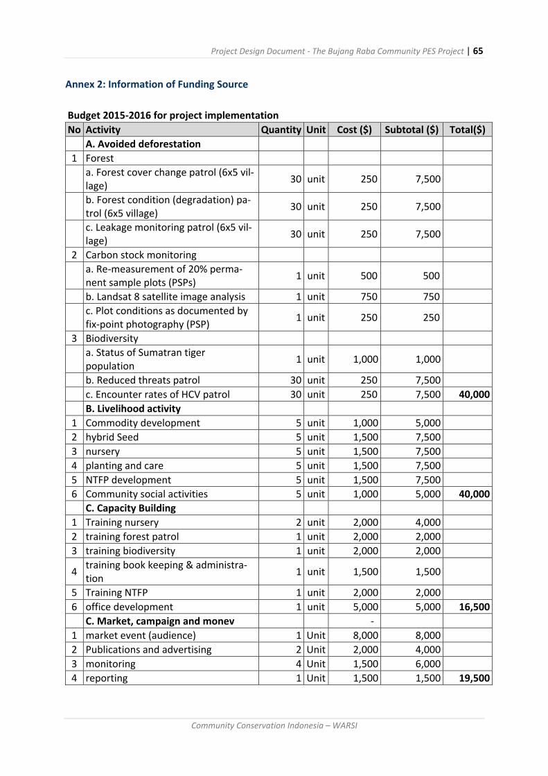
Project Design Document - The Bujang Raba Community PES Project | 65
Community Conservation Indonesia – WARSI
Annex 2: Information of Funding Source
Budget 2015-2016 for project implementation
No Activity Quantity Unit Cost ($) Subtotal ($) Total($)
A. Avoided deforestation
1 Forest
a. Forest cover change patrol (6x5 vil-lage)
30 unit 250 7,500
b. Forest condition (degradation) pa-trol (6x5 village)
30 unit 250 7,500
c. Leakage monitoring patrol (6x5 vil-lage)
30 unit 250 7,500
2 Carbon stock monitoring
a. Re-measurement of 20% perma-nent sample plots (PSPs)
1 unit 500 500
b. Landsat 8 satellite image analysis 1 unit 750 750
c. Plot conditions as documented by fix-point photography (PSP)
1 unit 250 250
3 Biodiversity
a. Status of Sumatran tiger population
1 unit 1,000 1,000
b. Reduced threats patrol 30 unit 250 7,500
c. Encounter rates of HCV patrol 30 unit 250 7,500 40,000
B. Livelihood activity
1 Commodity development 5 unit 1,000 5,000
2 hybrid Seed 5 unit 1,500 7,500
3 nursery 5 unit 1,500 7,500
4 planting and care 5 unit 1,500 7,500
5 NTFP development 5 unit 1,500 7,500
6 Community social activities 5 unit 1,000 5,000 40,000
C. Capacity Building
1 Training nursery 2 unit 2,000 4,000
2 training forest patrol 1 unit 2,000 2,000
3 training biodiversity 1 unit 2,000 2,000
4 training book keeping & administra-tion
1 unit 1,500 1,500
5 Training NTFP 1 unit 2,000 2,000
6 office development 1 unit 5,000 5,000 16,500
C. Market, campaign and monev -
1 market event (audience) 1 Unit 8,000 8,000
2 Publications and advertising 2 Unit 2,000 4,000
3 monitoring 4 Unit 1,500 6,000
4 reporting 1 Unit 1,500 1,500 19,500

Project Design Document - The Bujang Raba Community PES Project | 66
Community Conservation Indonesia – WARSI
WARSI Support Costs from RFN (2014 -2015)
No Activity Quantity
Unit Cost ($) Subtotal ($) Total ($)
A. Carbon Accounting
1 Carbon accounting specialist 6 unit 800 4,800
2 GIS/Remote Sensing Specialist 6 unit 800 4,800
3 Botanist 6 unit 800 4,800
4 Carbon Accounting 21 plot 400 8,400
5 Ground truth forest Cover 2 unit 1,500 3,000
6 Transportation 6 unit 400 2,400
7 Field Supply 5 unit 800 4,000
8 ATK 1 unit 1,500 1,500 33,700
B. Socio-Economic Program
1 Economic assessment 12 unit 800 9,600
2 Village Meetings (8 x 5 villages) 40 unit 200 8,000
3 Village Forest Council Meetings 4 unit 400 1,600
4 Transportation 6 unit 400 2,400
5 Field Supplies 5 unit 800 4,000
6 ATK 1 unit 1,200 1,200 26,800
C. Coordination and Support
1 Project Coordinator 6 unit 1,200 7,200
2 Telecoms 6 unit 120 720
3 Workshop team 6 unit 400 2,400
4 Transportation 6 unit 400 2,400
5 Meeting with supporting team 6 unit 800 4,800
6 Stationary 1 unit 1,200 1,200 18,720
Grand Total 79,220

Project Design Document - The Bujang Raba Community PES Project | 67
Community Conservation Indonesia – WARSI
Annex 3: Producer/group agreement template
The agreement attached below is translated as follows:
LETTER of DECLARATION
Communication Forum for Community Forest Management in Bathin III Ulu Sub-District,
Bungo District dated December 1, 2014.
Based on a series of discussions regarding the PROJECT REDD, the Communication Forum for
Community Forest Management that is comprised of a group of Village Forest Management
Councils has agreed to participate and implement the Project REDD in the Bujang Rava (Bukit
Panjang Rantau Bayur) and will implement the village forest management plans that we
have prepared.
With this decision we have appointed KKI WARSI to help with the implementation of the
REDD Project in Bujang Raba. The project will involve activities to reduce emissions from de-
forestation. This letter of declaration has been created and can be used to support the pro-
ject.
The letter is signed by the heads of the five participating village forest councils.

Project Design Document - The Bujang Raba Community PES Project | 68
Community Conservation Indonesia – WARSI
Annex 4: Database Template
Table Annex 4-a: Socio-Economic Database
Socio-economic monitoring form
Bujang Raba PES Project
Name of Village : __________________________
Year : __________________
No Activity Indicator Quarter 1
Quarter 2
Quarter 3
Quarter 4
Verification tools
Infor-mation
A
Women Coopera-tive 1
Number of Women Co-operative in the village
Report from women co-operative.
Financial re-port
2 Number of member
3
Number of saving ac-count in co-operative (IDR)
4
Number of benefit/profit (IDR)
B NTFP 1
Type of NTFP that is man-aged
Report from VFC
2
Number NTFP which is managed
3
Number of NTFP/handy craft sold
3 Total benefit (IDR)
C Health service 1
Number of people ac-cess health service
Report from head of Vil-
lage
D Educa-tion 1
Number of students en-rolled in high
Report from head of Vil-
lage
Project Design Document - The Bujang Raba Community PES Project | 69
Community Conservation Indonesia – WARSI
school and university
2
Number of university graduates
E Electric-ity 1
Number of household with access to electricity
Laporan Rio/kepala
desa
2
Number of households do not get access of electricity
F Garden 1
Total com-modity planted
Documen-tation of
seed nursury, to-tal produc-tion and so on from the
farmer group
a. Cocoa
b. Rubber
c. Cardamom
d. other
2
Number of production each of com-modity
a. Cocoa
b. Rubber
c. Cardamom
d. other
3
Number of ha farming area that has (not) been managed
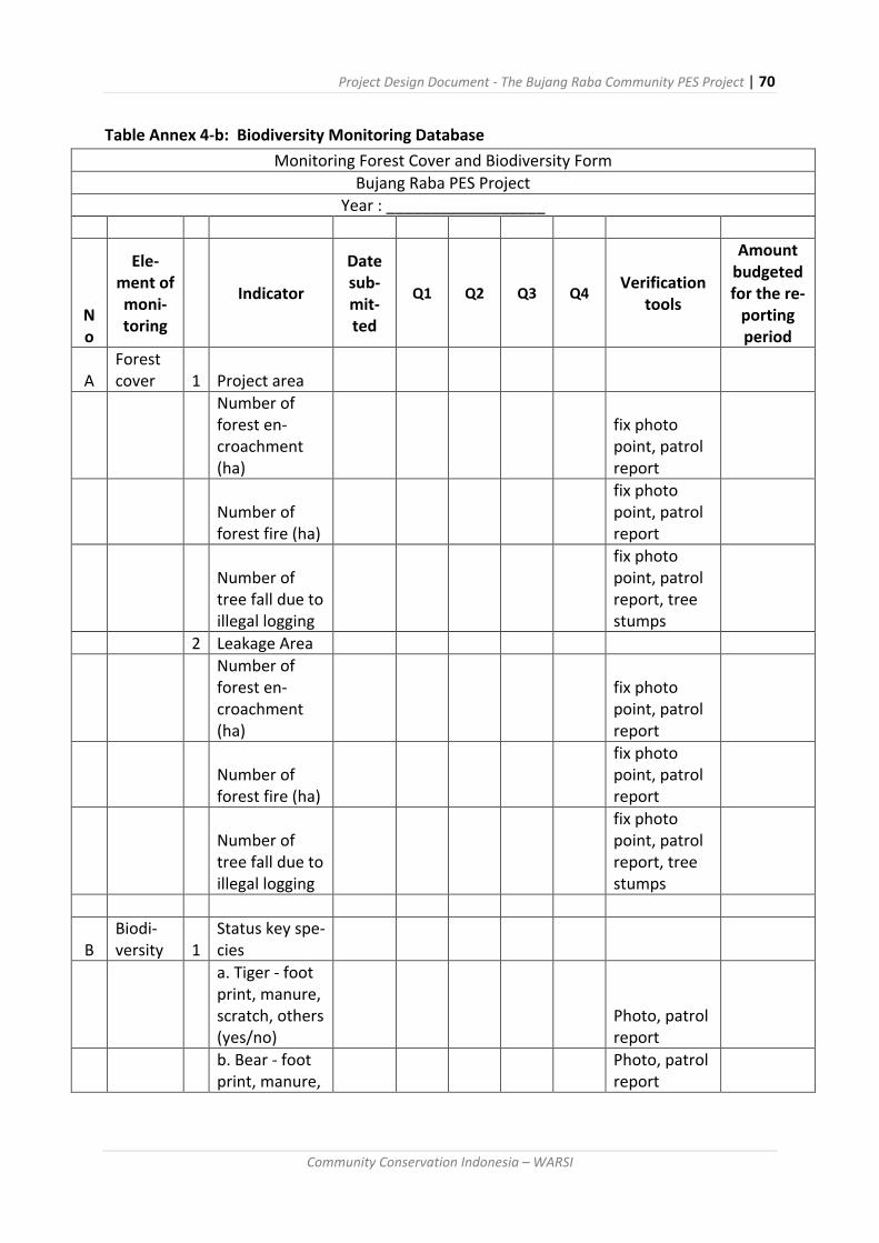
Project Design Document - The Bujang Raba Community PES Project | 70
Community Conservation Indonesia – WARSI
Table Annex 4-b: Biodiversity Monitoring Database
Monitoring Forest Cover and Biodiversity Form
Bujang Raba PES Project
Year : __________________
No
Ele-ment of moni-toring
Indicator
Date sub-mit-ted
Q1 Q2 Q3 Q4 Verification
tools
Amount budgeted for the re-
porting period
A Forest cover 1 Project area
Number of forest en-croachment (ha)
fix photo point, patrol report
Number of forest fire (ha)
fix photo point, patrol report
Number of tree fall due to illegal logging
fix photo point, patrol report, tree stumps
2 Leakage Area
Number of forest en-croachment (ha)
fix photo point, patrol report
Number of forest fire (ha)
fix photo point, patrol report
Number of tree fall due to illegal logging
fix photo point, patrol report, tree stumps
B Biodi-versity 1
Status key spe-cies
a. Tiger - foot print, manure, scratch, others (yes/no)
Photo, patrol report
b. Bear - foot print, manure,
Photo, patrol report

Project Design Document - The Bujang Raba Community PES Project | 71
Community Conservation Indonesia – WARSI
scratch, others (yes/no)
c. Other Spe-cies - foot print, manure, scratch, others (yes/no)
Photo, patrol report
2 Poaching (number case )
Photo, patrol report
3
Water quan-tity (drought, flood, dry) VFC report
4
Water quality (good, fair, bad) VFC report

Project Design Document - The Bujang Raba Community PES Project | 72
Community Conservation Indonesia – WARSI
Table Annex 4-c: WARSI Compilation Database
All this data is derived from the quarterly reports by the community
REPORT DETAILS FUNDING
AC
TI
VI-
TIE
S MONITORING DURING PATROL FISH CATCH OTHER FEEDBACK
No
Dat
e su
bm
itte
d
Qu
arte
r re
po
rted
Year
Vill
age/
VFC
Am
ou
nt
bu
dge
ted
for
the
rep
ort
ing
per
iod
A
mo
un
t u
sed
du
r-
ing
the
rep
ort
ing
per
iod
B
alan
ce in
ac-
cou
nt
da
te
Bal
ance
in c
ash
da
te
Act
ivit
y 1
pro
of
(Y/N
) b
y
WA
RSI
A
ctiv
ity
2
pro
of
(Y/N
) b
y
WA
RSI
A
ctiv
ity
3
pro
of
(Y/N
) b
y
WA
RSI
A
ctiv
ity
4
pro
of
(Y/N
) b
y
WA
RSI
xx
x
dat
e o
f p
atro
l
Fore
st c
lear
ed
ha
esti
mat
e
pla
ce (
s)
Illeg
ally
fel
led
tree
s n
o e
stim
ate
pla
ce (
s)
Bu
rnt
are
a
ha
esti
mat
e
pla
ce (
s)
Oth
er r
emar
ks o
n
fore
st d
estr
uct
ion
du
rin
g p
atro
l In
dic
ato
r Sp
ecie
s
1
pro
of
(sig
hti
ng,
dro
pp
ing,
fo
ot-
mar
ks..
) p
lace
(s)
Ind
icat
or
Spec
ies
2
pro
of
(sig
hti
ng,
dro
pp
ing,
fo
ot-
mar
ks..
) p
lace
(s)
Ind
icat
or
Spec
ies
3
pro
of
(sig
hti
ng,
dro
pp
ing,
fo
ot-
mar
ks..
) p
lace
(s)
Ind
icat
or
Spec
ies
4
pro
of
(sig
hti
ng,
dro
pp
ing,
fo
ot-
mar
ks..
) p
lace
(s)
Oth
er r
emar
ks o
n
bio
div
ersi
ty
Riv
er 1
Pla
ce A
Fish
cat
ch (
scal
e
1-3
) P
lace
B
Fish
cat
ch (
scal
e
1-3
)
Rem
arks
on
ille
gal
acti
viti
es/f
ore
st
clea
ran
ce
Rem
arks
on
bio
di-
vers
ity
Rem
arks
on
wat
er
avai
lab
ility
Sugg
esti
on
s, r
ec-
om
men
dat
ion
s
1 20
.3.2
016
1st
20
16
Lub
uk
Ber
ing
in
2
3
4
5
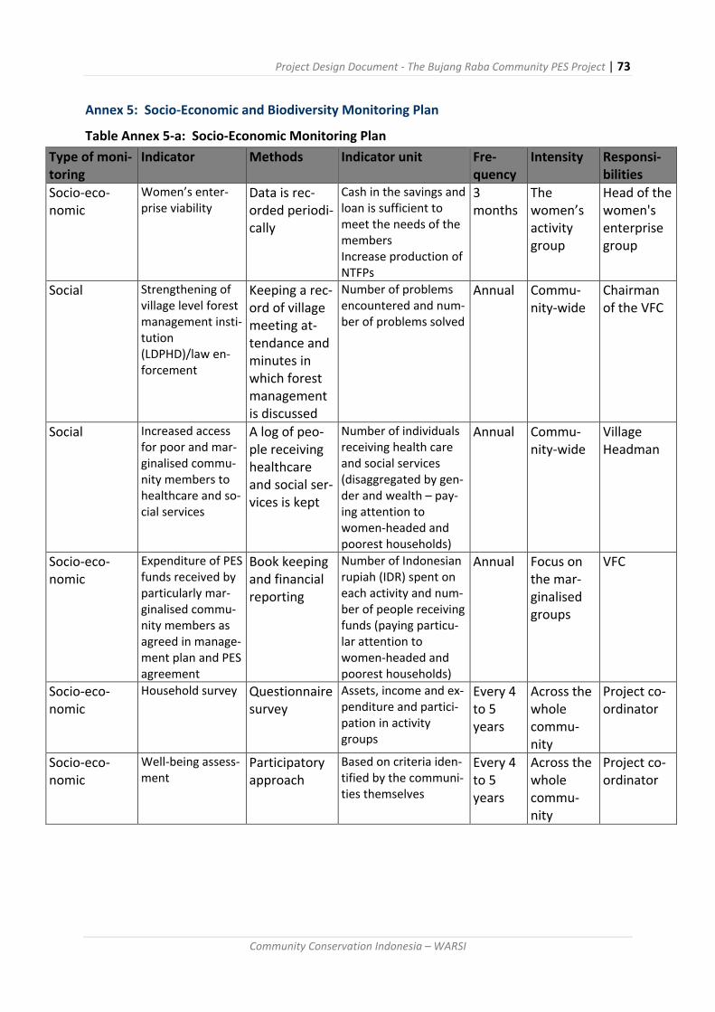
Project Design Document - The Bujang Raba Community PES Project | 73
Community Conservation Indonesia – WARSI
Annex 5: Socio-Economic and Biodiversity Monitoring Plan
Table Annex 5-a: Socio-Economic Monitoring Plan
Type of moni-toring
Indicator Methods Indicator unit Fre-quency
Intensity Responsi-bilities
Socio-eco-nomic
Women’s enter-prise viability
Data is rec-orded periodi-cally
Cash in the savings and loan is sufficient to meet the needs of the members Increase production of NTFPs
3 months
The women’s activity group
Head of the women's enterprise group
Social Strengthening of village level forest management insti-tution (LDPHD)/law en-forcement
Keeping a rec-ord of village meeting at-tendance and minutes in which forest management is discussed
Number of problems encountered and num-ber of problems solved
Annual Commu-nity-wide
Chairman of the VFC
Social Increased access for poor and mar-ginalised commu-nity members to healthcare and so-cial services
A log of peo-ple receiving healthcare and social ser-vices is kept
Number of individuals receiving health care and social services (disaggregated by gen-der and wealth – pay-ing attention to women-headed and poorest households)
Annual Commu-nity-wide
Village Headman
Socio-eco-nomic
Expenditure of PES funds received by particularly mar-ginalised commu-nity members as agreed in manage-ment plan and PES agreement
Book keeping and financial reporting
Number of Indonesian rupiah (IDR) spent on each activity and num-ber of people receiving funds (paying particu-lar attention to women-headed and poorest households)
Annual Focus on the mar-ginalised groups
VFC
Socio-eco-nomic
Household survey Questionnaire survey
Assets, income and ex-penditure and partici-pation in activity groups
Every 4 to 5 years
Across the whole commu-nity
Project co-ordinator
Socio-eco-nomic
Well-being assess-ment
Participatory approach
Based on criteria iden-tified by the communi-ties themselves
Every 4 to 5 years
Across the whole commu-nity
Project co-ordinator

Project Design Document - The Bujang Raba Community PES Project | 74
Community Conservation Indonesia – WARSI
Table Annex 5b: Examples of well-being indicators that may be used as part of the socio-
economic monitoring plan
Criteria Poor Medium Rich
House
Walls
Support
posts
Roof
Floor
House
Size
Rooms
Bamboo
Unmilled timber
Leaves
Dirt or bamboo
4x6 m
1 bedroom and
kitchen
Rough Cement
Milled timber
Tin sheeting
Milled timber or
cement
6x9 m
2-3 bedrooms and
kitchen
Refined Ce-
ment
Milled tim-
ber/cement
Tile
6x12.
3-4 bedrooms,
kitchen, living
room 1-2 story
Electricity
Oil lamp and ille-
gal electrical
hook-up
Electrical supply
900w-1300w.
Electrical sup-
ply 2000w.
with back-up
generator
Electronics & Vehicles Radio, TV, motor cycle
Refrigerator,
washing ma-
chine, motor-
cycle, car. Flat
screen TV
Land ownership <3ha/ household
3-10 ha/ house-
hold
10+ha per
household
Agroforestry gardens <1 ha 1-5 ha >5 ha
Work Day labourer,
farmer
Company em-
ployee, teacher,
civil servant, farm-
ers
Company man-
ager, govern-
ment officials,
middleman,
farmer
Income <Rp 1 million Rp 1 to 10 million > Rp 10 million
Sanitation facilities No bathroom or
toilet
Simple Bathroom
and toilet
(no tile)
Tiled bathroom
and toilet

Project Design Document - The Bujang Raba Community PES Project | 75
Community Conservation Indonesia – WARSI
Table annex 5c: Environmental and biodiversity monitoring plan
Moni-toring type
Indicator Methods Indicator unit
Fre-quency
Intensity Respon-sibilities
Forest Forest cover change
patrols Number of hectares of cleared/ burnt forest
2 months
10km long pa-trol route, usually lasting at least 3 days every month
VFC
Forest condition (degradation)
patrols Number of felled trees
2 months
10 km long patrol route, usually lasting at least 3 days every month
VFC
Leakage moni-toring
patrols Number of hectares of burnt and cleared trees in leakage zone
2 months
10km long pa-trol route, usually lasting at least 3 days every month
VFC
Carbon stock monitoring
Re-meas-urement of permanent sample plots (PSPs)
Number of hectares of cleared for-est and num-ber of felled trees
Annual
20% of PSPs Commu-nity pa-trols with WARSI team
Landsat 8 satellite im-age analysis following WARSI pro-cedural document
Number of hectares of forest by for-est strata/classes
Annual Protection zone
WARSI remote sensing expert
Plot condi-tions as docu-mented by fix-point photog-raphy (PSP).
Extent of cleared ar-eas/intact ar-eas
Annual 20% of PSPs VFC and WARSI
Forest condition (degradation)
SPOT satel-lite image classifica-tion
Hectares of degraded for-est
Every 5 years
Protection zone
WARSI remote sensing expert

Project Design Document - The Bujang Raba Community PES Project | 76
Community Conservation Indonesia – WARSI
Leakage mitiga-tion
Data is rec-orded peri-odically
Number of community members in-volved in livelihood and rehabili-tation activi-ties
Annual Village-wide WARSI
Biodiver-sity
Status of Suma-tran tiger popu-lation
Camera traps
Number of recorded in-dividuals
Annual Protection zone
WARSI
Reduced threats patrols (encroach-ment, poach-ing, illegal, logging, hu-man wildlife conflict, fire)
2 months
10km long pa-trol route, usually lasting at least 3 days every month
VCF
Encounter rates of high conser-vation value species
patrols Frequency of sightings per HCV species
2 months
10km long pa-trol route, usually lasting at least 3 days every month
VCF
Water Water availabil-ity
Check how many times does the water pump break be-cause there is too little water
Number of times the mi-cro-hydro station stops working be-cause of lim-ited water supply, Number of times water to rice fields is delayed
Annual Micro-hydro station, sawah
VCF
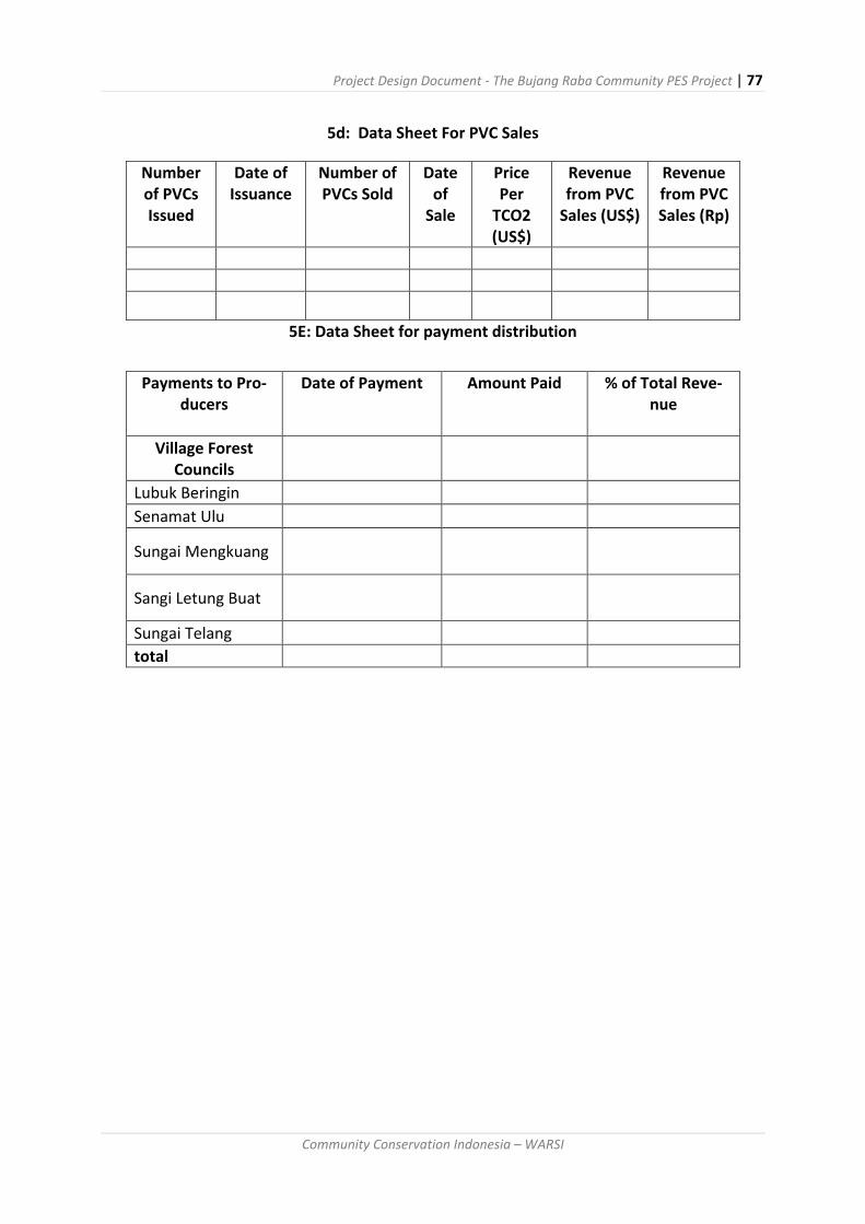
Project Design Document - The Bujang Raba Community PES Project | 77
Community Conservation Indonesia – WARSI
5d: Data Sheet For PVC Sales
Number of PVCs Issued
Date of Issuance
Number of PVCs Sold
Date of
Sale
Price Per
TCO2 (US$)
Revenue from PVC
Sales (US$)
Revenue from PVC Sales (Rp)
5E: Data Sheet for payment distribution
Payments to Pro-ducers
Date of Payment Amount Paid % of Total Reve-nue
Village Forest Councils
Lubuk Beringin
Senamat Ulu
Sungai Mengkuang
Sangi Letung Buat
Sungai Telang
total

Project Design Document - The Bujang Raba Community PES Project | 78
Community Conservation Indonesia – WARSI
Annex 6: Example Forest Management Plan
Each Forest Village Council has prepared plans for their forest area indicating major land use
categories including: protected forests, complex agroforestry systems that mimic natural for-
ests, simple agroforests that focus on a few commodities, rice fields, abandoned rice fields
and settlements. The map of Lubuk Beringin Village and its communal forests is an example
of the types of plans that will guide the project and community land use decision-making.
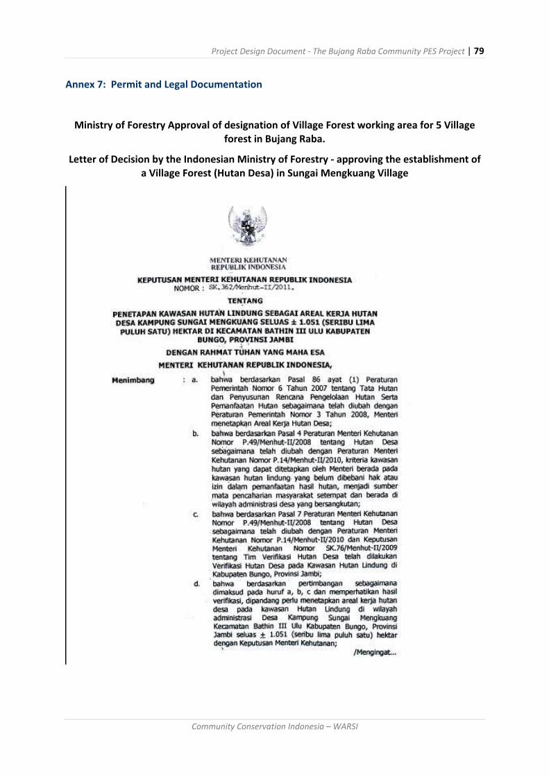
Project Design Document - The Bujang Raba Community PES Project | 79
Community Conservation Indonesia – WARSI
Annex 7: Permit and Legal Documentation
Ministry of Forestry Approval of designation of Village Forest working area for 5 Village forest in Bujang Raba.
Letter of Decision by the Indonesian Ministry of Forestry - approving the establishment of a Village Forest (Hutan Desa) in Sungai Mengkuang Village
Project Design Document - The Bujang Raba Community PES Project | 80
Community Conservation Indonesia – WARSI

Project Design Document - The Bujang Raba Community PES Project | 81
Community Conservation Indonesia – WARSI
Project Design Document - The Bujang Raba Community PES Project | 82
Community Conservation Indonesia – WARSI
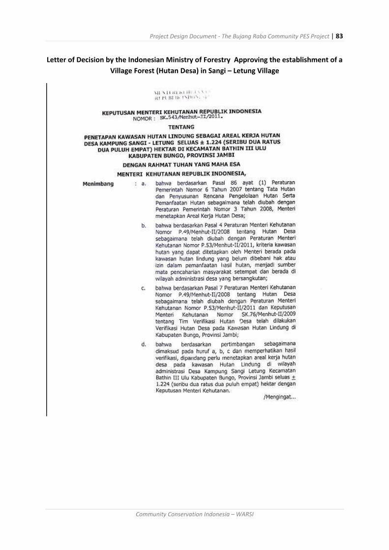
Project Design Document - The Bujang Raba Community PES Project | 83
Community Conservation Indonesia – WARSI
Letter of Decision by the Indonesian Ministry of Forestry Approving the establishment of a
Village Forest (Hutan Desa) in Sangi – Letung Village

Project Design Document - The Bujang Raba Community PES Project | 84
Community Conservation Indonesia – WARSI

Project Design Document - The Bujang Raba Community PES Project | 85
Community Conservation Indonesia – WARSI

Project Design Document - The Bujang Raba Community PES Project | 86
Community Conservation Indonesia – WARSI

Project Design Document - The Bujang Raba Community PES Project | 87
Community Conservation Indonesia – WARSI
Letter of Decision by the Indonesian Ministry of Forestry Approving the establishment of a
Village Forest (Hutan Desa) in Senamat Ulu Village

Project Design Document - The Bujang Raba Community PES Project | 88
Community Conservation Indonesia – WARSI

Project Design Document - The Bujang Raba Community PES Project | 89
Community Conservation Indonesia – WARSI
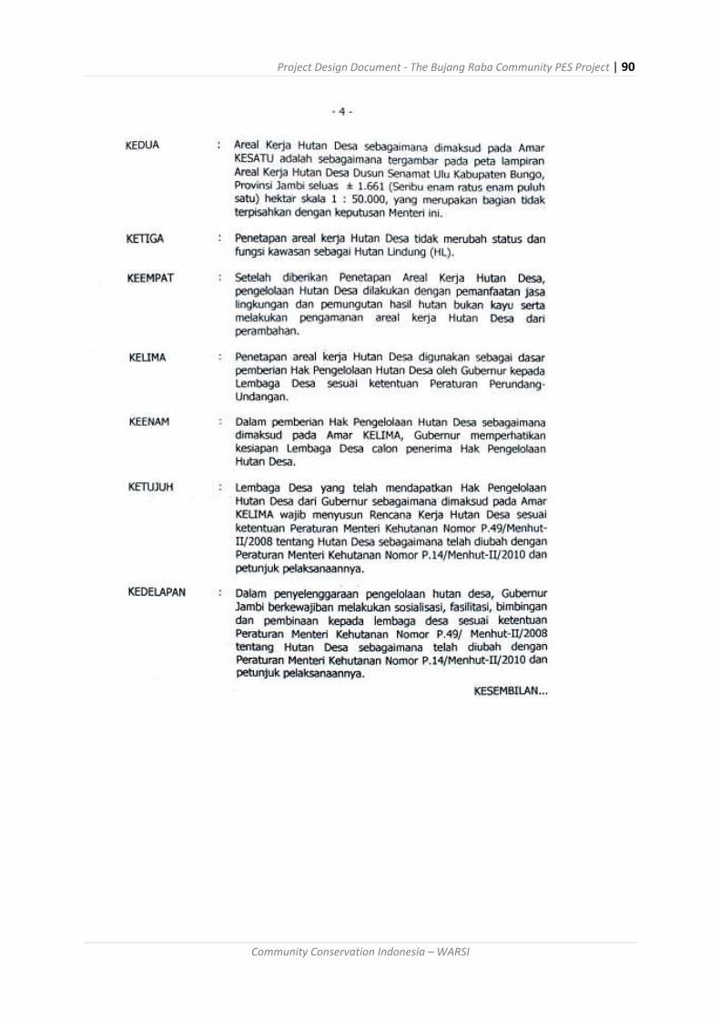
Project Design Document - The Bujang Raba Community PES Project | 90
Community Conservation Indonesia – WARSI
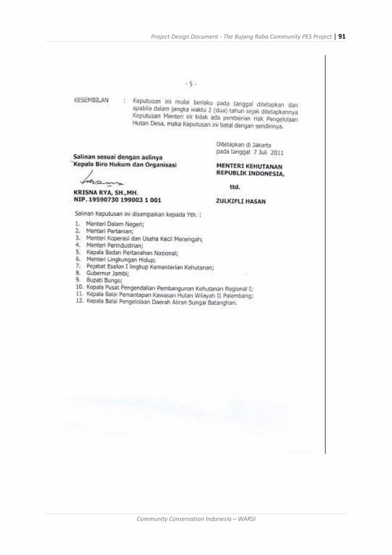
Project Design Document - The Bujang Raba Community PES Project | 91
Community Conservation Indonesia – WARSI

Project Design Document - The Bujang Raba Community PES Project | 92
Community Conservation Indonesia – WARSI
Letter of Decision by the Indonesian Ministry of Forestry Approving the establishment of a
Village Forest (Hutan Desa) in Desa Sungai Telang
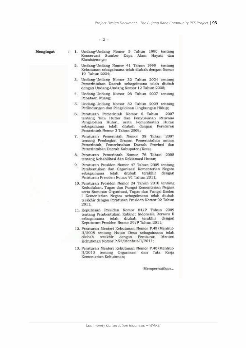
Project Design Document - The Bujang Raba Community PES Project | 93
Community Conservation Indonesia – WARSI

Project Design Document - The Bujang Raba Community PES Project | 94
Community Conservation Indonesia – WARSI

Project Design Document - The Bujang Raba Community PES Project | 95
Community Conservation Indonesia – WARSI
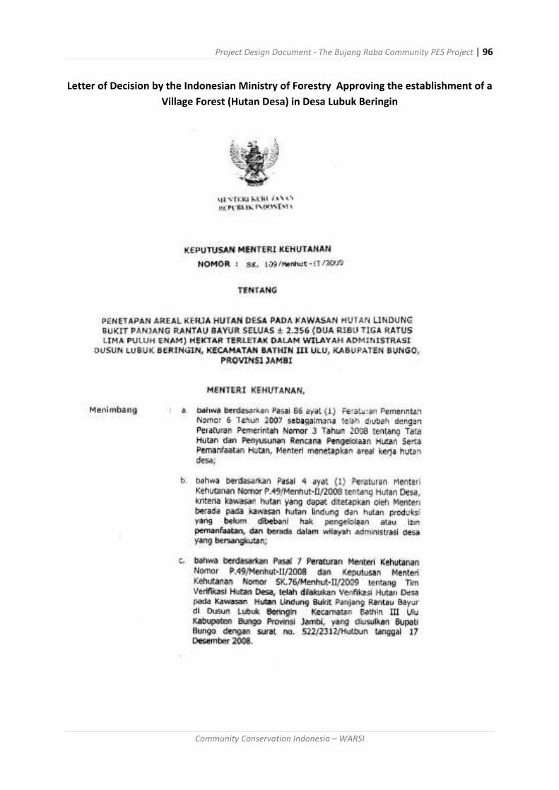
Project Design Document - The Bujang Raba Community PES Project | 96
Community Conservation Indonesia – WARSI
Letter of Decision by the Indonesian Ministry of Forestry Approving the establishment of a
Village Forest (Hutan Desa) in Desa Lubuk Beringin

Project Design Document - The Bujang Raba Community PES Project | 97
Community Conservation Indonesia – WARSI
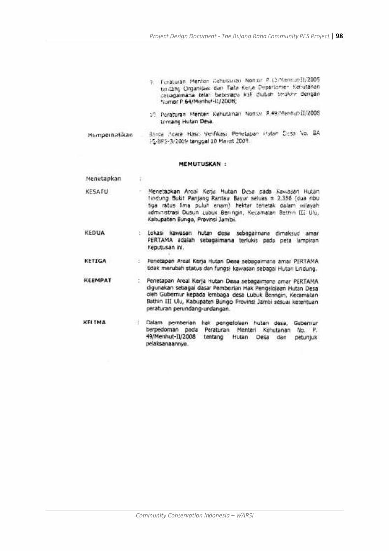
Project Design Document - The Bujang Raba Community PES Project | 98
Community Conservation Indonesia – WARSI

Project Design Document - The Bujang Raba Community PES Project | 99
Community Conservation Indonesia – WARSI
Annex 8: Evidence of Participation
The project has gone through an elaborate participatory process over the past year in pre-paring for the REDD project. Representatives from all five participating communities gath-ered for a series of planning activities in 2014-2015 including:
September 2014 - REDD Awareness Meeting
November 2014 - Carbon Accounting Meeting
December 2014 - Meeting of Village Forest Council Heads and Members to Approve the REDD Project
January 2015 - Village Forest Management Planning Meeting
March 2015 - PRA and Sketch Mapping Meetings Video of these activities are shown below: Community Carbon - The Village Forest of Bujang Raba https://www.youtube.com/watch?v=cuL_jOc_EdY Photos of these activities are shown below:
REDD+ Awareness Meeting, September 2014 (Photo: Fredi)

Project Design Document - The Bujang Raba Community PES Project | 100
Community Conservation Indonesia – WARSI
Forest Carbon Modelling Meeting, November 2014 (Photo: Dinaldi)

Project Design Document - The Bujang Raba Community PES Project | 101
Community Conservation Indonesia – WARSI
Village Forest Management Planning Meetings, January 2015 (Photo: Fredi Yusuf)

Project Design Document - The Bujang Raba Community PES Project | 102
Community Conservation Indonesia – WARSI
PRA Meeting, March 2015 (Photo: Fredi Yusuf)

Project Design Document - The Bujang Raba Community PES Project | 103
Community Conservation Indonesia – WARSI
Sketch Maps of Dusun Buat, March 2015 (Photo: Fredi Yusuf)


