1/19/2011 1 NYS Department of Environmental Conservation NYS Department of Environmental Conservation January 13, 2010 1 ` Discuss the Interim Remedial Measures (IRMs) proposed by NYSDEC and EPA at two sites adjacent to Onondaga Lake ◦ Wastebed B/Harbor Brook site East Barrier Wall IRM ◦ Wastebeds 1-8 site IRM NYS Department of Environmental Conservation ` Proposed Response Action Documents (PRADs) ◦ Identifies NYSDEC’s and EPA’s preferred response action at each of these sites ◦ Public comment period commenced on December 27, 2010 and will close on February 10, 2011 2 ` Wastebed B/Harbor Brook site East Barrier Wall IRM PRAD ◦ Engineering Evaluation/Cost Analysis (EE/CA) x Evaluates actions to address contamination that is migrating from the site to Onondaga Lake and Harbor Brook NYS Department of Environmental Conservation Brook ` Solvay Wastebeds 1-8 site IRM PRAD ◦ Focused Feasibility Study (FFS) - equivalent to an EE/CA x Evaluates actions to address contamination that is migrating from the site to Onondaga Lake and Ninemile Creek 3 ` Site Background ◦ Site location/disposal history ◦ Investigations performed ◦ Environmental conditions ` IRM Objective NYS Department of Environmental Conservation ` Preferred Response Action ` Next Steps ` These will be presented separately for the Waste Bed B/Harbor Brook and Waste Beds 1-8 sites 5
Transcript
1/19/2011
1
NYS Department of Environmental Conservation
NYS Department of Environmental Conservation
January 13, 2010
1
Discuss the Interim Remedial Measures (IRMs) proposed by NYSDEC and EPA at two sites adjacent to Onondaga Lake ◦ Wastebed B/Harbor Brook site East Barrier Wall IRM◦ Wastebeds 1-8 site IRM
action at each of these sites◦ Public comment period commenced on December 27,
2010 and will close on February 10, 2011
2
Wastebed B/Harbor Brook site East Barrier Wall IRM PRAD◦ Engineering Evaluation/Cost Analysis (EE/CA)
Evaluates actions to address contamination that is migrating from the site to Onondaga Lake and Harbor Brook
NYS Department of Environmental Conservation
BrookSolvay Wastebeds 1-8 site IRM PRAD◦ Focused Feasibility Study (FFS) - equivalent to an
EE/CAEvaluates actions to address contamination that is migrating from the site to Onondaga Lake and NinemileCreek
3
Site Background◦ Site location/disposal history◦ Investigations performed◦ Environmental conditionsIRM Objective
NYS Department of Environmental Conservation
Preferred Response ActionNext StepsThese will be presented separately for the Waste Bed B/Harbor Brook and Waste Beds 1-8 sites
5
1/19/2011
2
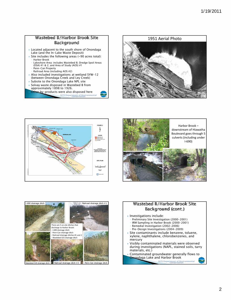
Located adjacent to the south shore of Onondaga Lake (and the In-Lake Waste Deposit)Site includes the following areas (~90 acres total):◦ Harbor Brook◦ Lakeshore Area: includes Wastebed B; Dredge Spoil Areas
(DSA) #1 & 2; and Area of Study (AOS) #1
NYS Department of Environmental Conservation
◦ Penn-Can Property◦ Railroad Area (including AOS #2)Also included investigations at wetland SYW-12 (between Onondaga Creek and Ley Creek)Subsite to the Onondaga Lake NPL siteSolvay waste disposed in Wastebed B from approximately 1898 to 1926.Other by-products were also disposed here
7
1951 Aerial Photo
Harbor Brook –downstream of Hiawatha Boulevard goes through 5 culverts (including under
I‐690)
I-690 drainage ditch Railroad drainage ditch #1
There are 5 on‐site ditches that discharge to Harbor Brook:‐ I‐690 drainage ditch‐ Penn‐Can drainage ditch
Railroad drainage ditch #2
Penn Can drainage ditch‐ Railroad drainage ditches #1 and 2‐Wastebed D/E drainage ditch
Investigations include:◦ Preliminary Site Investigation (2000-2001)◦ IRM Sampling in Harbor Brook (2000-2001)◦ Remedial Investigation (2002-2006)◦ Pre-Design Investigations (2004-2009)Site contaminants include benzene toluene
NYS Department of Environmental Conservation
Site contaminants include benzene, toluene, xylene, naphthalene, chlorobenzenes, and mercuryVisibly contaminated materials were observed during investigations (NAPL, stained soils, tarry materials, etc.)Contaminated groundwater generally flows to Onondaga Lake and Harbor Brook
12
1/19/2011
3
IRM Consent Order Signed in 2001IRM Objectives◦ Eliminate, to the extent practicable, the discharge
of contaminated ground water and non-aqueous phase liquids (NAPL) into Harbor Brook and
NYS Department of Environmental Conservation
phase liquids (NAPL) into Harbor Brook and Onondaga Lake◦ Eliminate, to the extent practicable, potential
impacts to human health and to the environment (e.g., to fish and wildlife resources)
15
West Barrier Wall (work underway)◦ expected completion in early 2011East Barrier Wall◦ work expected to begin in 2011Upper Harbor Brook (includes sediment removal within Harbor Brook its tributaries
NYS Department of Environmental Conservation
removal within Harbor Brook, its tributaries and associated wetlands)◦ work expected to begin in 2011Outboard Area (soil/sediment removal and wetland restoration between the East and West Barrier Walls and Onondaga Lake)◦ will be addressed in another PRAD in 2011
16
West Wall installation
(August 2010)
1/19/2011
4
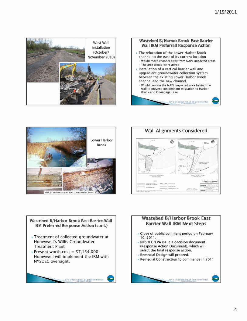
West Wall installation (October/
November 2010)The relocation of the Lower Harbor Brook channel to the east of its current location◦ Would move channel away from NAPL impacted areas◦ The area would be restoredInstallation of a vertical barrier wall and
NYS Department of Environmental Conservation
upgradient groundwater collection system between the existing Lower Harbor Brook channel and the new channel.◦ Would contain the NAPL impacted area behind the
wall to prevent contaminant migration to Harbor Brook and Onondaga Lake
20
Lower Harbor Brook
NAPL in sediment cores from Lower Harbor Brook
Wall Alignments Considered
Treatment of collected groundwater at Honeywell’s Willis Groundwater Treatment Plant
NYS Department of Environmental Conservation
Present worth cost = $7,154,000. Honeywell will implement the IRM with NYSDEC oversight.
23
Close of public comment period on February 10, 2011.NYSDEC/EPA issue a decision document (Response Action Document), which will
l t th fi l ti
NYS Department of Environmental Conservation
select the final response action.Remedial Design will proceed.Remedial Construction to commence in 2011
24
1/19/2011
5
Complete the Remedial Investigation/ Feasibility StudyIssue a Proposed Plan for the siteI R d f D i i
NYS Department of Environmental Conservation
Issue a Record of Decision
25NYS Department of Environmental Conservation 26
Located adjacent to the western shore of Onondaga Lake (between State Fair Boulevard and Onondaga Lake)Covers more than 300 acres (~1 mile x 0.5 miles)Subsite to the Onondaga Lake NPL site
NYS Department of Environmental Conservation
Subsite to the Onondaga Lake NPL siteCurrently owned by Onondaga County and NYS Dept of Agriculture and MarketsSolvay Waste disposed in Wastebeds 1-8 from approximately 1926 to 1943Other by-products have also been disposed here
28
Wastebeds 1‐8 (1948)
Waste was pumped to diked lagoons. Water was evaporated and/or decanted; leaving behind a hard chalky substance
29
Investigations include:◦ Allied Wastebeds Evaluation (1987)◦ Evaluation by DEC to determine presence of
hazardous waste (1995)P li i Sit A t (2005)
NYS Department of Environmental Conservation
◦ Preliminary Site Assessment (2005)◦ Remedial Investigation/Feasibility Study (ongoing)IRM being performed under the Wastebeds 1-8 Consent Order signed in 2004
30
1/19/2011
6
Wastebeds 1-8 shoreline
Site contaminants include benzene, toluene, xylene, naphthalene and phenolsContaminated groundwater generally flows to Onondaga LakeSurface water seeps that discharge
t i t d t t
NYS Department of Environmental Conservation
contaminated water are presentVisibly contaminated materials observed at the base of the Solvay waste during investigationsMercury is not a major contaminant of concern at this site
32
Wastebeds 1-8
Wastebeds 1-8 seeps
Objectives of this IRM are to mitigate:◦ Direct contact with and ingestion of exposed Solvay waste and
other contaminated soil along the eastern shore of the site (western shore of Onondaga Lake);
◦ Discharge of Ninemile Creek Sand and Gravel (former NinemileCreek channel) groundwater unit and eastern shore groundwater to Onondaga Lake and Ninemile Creek;
◦ Discharge of shallow and intermediate groundwater to Ditch A (an on-site drainage ditch);Di i h d h di h f Ni il
NYS Department of Environmental Conservation
◦ Direct contact with seep water, and the discharge of NinemileCreek bank seep water, and eastern and northern shore seep water to Onondaga Lake and Ninemile Creek;
◦ Erosion of Solvay waste from the eastern shore to Onondaga Lake;◦ Erosion of Solvay waste along the northern shore of the site due to
wind and wave action;◦ Erosion of Solvay waste substrate and sediment from the lower
reach of Ditch A to Onondaga Lake; and◦ Discharge of seep water from the upper reach of Ditch A to
Ninemile Creek.
35
Hydraulic control of groundwater, primarily along the eastern shore via a groundwater collection trench and passive collection systemA 14.4 acre vegetative cover along the eastern shoreHydraulic control of the Ninemile Creek Sand and
NYS Department of Environmental Conservation
Gravel unit groundwater via collection wellsHydraulic control of seeps along the eastern shore of the site, and selected seeps along Ninemile Creek and the northern shore, via installation of seep collection trenchesTreatment of collected seep water and groundwater at Honeywell’s Willis Groundwater Treatment Plant
36
1/19/2011
7
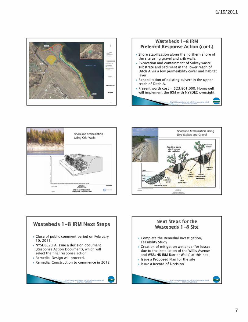
37
Shore stabilization along the northern shore of the site using gravel and crib walls.Excavation and containment of Solvay waste substrate and sediment in the lower reach of Ditch A via a low permeability cover and habitat
NYS Department of Environmental Conservation
Ditch A via a low permeability cover and habitat layer.Rehabilitation of existing culvert in the upper reach of Ditch A.Present worth cost = $23,801,000. Honeywell will implement the IRM with NYSDEC oversight.
38
Shoreline Stabilization Using Crib Walls
Shoreline Stabilization Using Live Stakes and Gravel
Close of public comment period on February 10, 2011.NYSDEC/EPA issue a decision document (Response Action Document), which will
NYS Department of Environmental Conservation
(Response Action Document), which will select the final response action.Remedial Design will proceed.Remedial Construction to commence in 2012
41
Complete the Remedial Investigation/ Feasibility StudyCreation of mitigation wetlands (for losses due to the installation of the Willis Avenue
NYS Department of Environmental Conservation
due to the installation of the Willis Avenue and WBB/HB IRM Barrier Walls) at this site.Issue a Proposed Plan for the siteIssue a Record of Decision