“The presence of underground water, if not properly considered and managed, can produce significant delays in construction and increase the cost.” Water inflows in deep excavations in karstified rock A spotlight on Qatar ARTICLE Since the dawn of mankind, underground structures, either natural or manmade, were part of life. From the Eupalinian Aqueduct built in the sixth century BC to the deep excavations for the high-rise buildings of Manhattan skyline, to the Doha Metro, the geotechnical sector has become a very specialised industry. To achieve a smooth design-construction synergy, it is essential to appoint experienced designers to achieve the correct results. In this field, as in others, nature provides many challenges and we must draw lessons from failures, improve techniques and use all our resources of creativity to succeed. What are the key factors impacting deep excavations? Deep excavations are required to accommodate buildings, shafts or other local underground structures related to urban expansion. From a geotechnical perspective, the geology, the stratigraphy, the groundwater regime and the surrounding geometrical and loading restraints must be considered. Although all factors are important, any potential stability problem can be accommodated with a more robust retaining system. The presence of underground water, if not properly considered and managed, can produce significant delays in construction and increase the cost. The full understanding of which remains unknown until the works are out of the ground and reaching skywards. As such, these projects typically face many uncertainties and significant risk such as: — unreliable predictions of ground conditions; — complex technological challenges; and — the need for intensive investigations before and during construction.
Transcript
A - Front Page two line title
“The presence of underground water, if not properly considered and managed, can produce significant delays in construction and increase the cost.”
Doc Title Water inflows in deep excavations in karstified rock: A spotlight on Qatar
Water inflows in deep excavations in karstified rockA spotlight on Qatar
ARTICLE
Since the dawn of mankind, underground structures, either natural or manmade, were part of life. From the Eupalinian Aqueduct built in the sixth century BC to the deep excavations for the high-rise buildings of Manhattan skyline, to the Doha Metro, the geotechnical sector has become a very specialised industry.
To achieve a smooth design-construction synergy, it is essential to appoint experienced designers to achieve the correct results. In this field, as in others, nature provides many challenges and we must draw lessons from failures, improve techniques and use all our resources of creativity to succeed.
What are the key factors impacting deep excavations?
Deep excavations are required to accommodate buildings, shafts or other local underground structures related to urban expansion. From a geotechnical perspective, the geology, the stratigraphy, the groundwater regime and the surrounding geometrical and loading restraints must be considered.
Although all factors are important, any potential stability problem can be accommodated with a more robust retaining system. The presence of underground water, if not properly considered and managed, can produce significant delays in construction and increase the cost. The full understanding of which remains unknown until the works are out of the ground and reaching skywards. As such, these projects typically face many uncertainties and significant risk such as:
— unreliable predictions of ground conditions;
— complex technological challenges; and
— the need for intensive investigations before and during construction.
FTI Consulting, Inc. 02WATER InfLoWs In dEEp ExCAvATIons In kARsTIfIEd RoCk: A spoTLIghT on QATAR
B - Continuation Page (non-spread) for online/digital only, non print
These factors, coupled with the different interests of those either directly or indirectly involved, almost always leads to disputes, either between the Contractors with the Designer for not properly assessing the prevailing conditions or between the Contractors and the Clients for unforeseeable conditions.
Going underground requires the acquisition of the substratum’s knowledge by understanding the geology anticipated and determining the required support system for the excavation. It is also mandatory to understand the surroundings to establish the loading conditions from buildings or identify potential obstacles that will require special handling like existing underground utilities or deep founded buildings. Although the above could allow the designer to propose and design the required support system in relation to the geology and loading conditions, the deep knowledge of the groundwater regime is critical, because the improper treatment of such information may lead to unforeseen conditions during the construction.
The groundwater circulation is related to the porosity of the underground mass and categorised into two main categories (i) primary and (ii) secondary, although other types of porosity exist. The primary porosity is associated with the original depositional texture of the sediment and applies to soil formations, whilst the secondary porosity is related to the water circulation through openings in rocks, like discontinuities, fissures and fractures (also characterised as fractured flow) or voids in karstified formations.
Karstification – how to minimise flooding
Karstification usually refers to the process where carbonate formations like limestone, dolomites and gypsum are exposed to leeching and dissolution by atmospheric or brackish water. When the rock formations dissolve, openings, vugs and caves are formed, called karst. The karsts can be filled with water, soil or be empty, depending on the hydrogeological regime and history of the area. When a karst is full of water, it can be connected to a larger water reservoir, such as the sea, with unlimited drainage capacity and, if encountered during construction
“...the deep knowledge of the groundwater regime is critical, because the improper treatment of such information may lead to unforeseen conditions during the construction.”
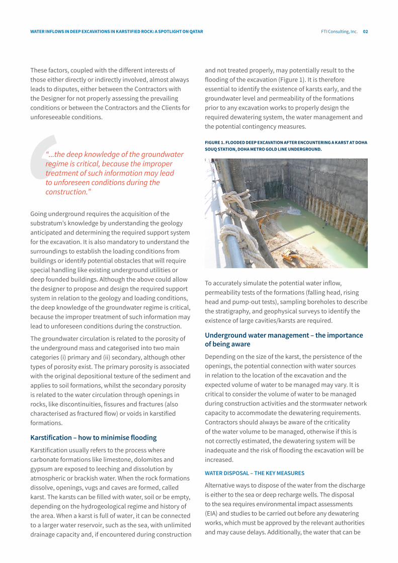
and not treated properly, may potentially result to the flooding of the excavation (Figure 1). It is therefore essential to identify the existence of karsts early, and the groundwater level and permeability of the formations prior to any excavation works to properly design the required dewatering system, the water management and the potential contingency measures.
fIgURE 1. fLoodEd dEEp ExCAvATIon AfTER EnCoUnTERIng A kARsT AT dohA soUQ sTATIon, dohA METRo goLd LInE UndERgRoUnd.
To accurately simulate the potential water inflow, permeability tests of the formations (falling head, rising head and pump-out tests), sampling boreholes to describe the stratigraphy, and geophysical surveys to identify the existence of large cavities/karsts are required.
Underground water management – the importance of being aware
Depending on the size of the karst, the persistence of the openings, the potential connection with water sources in relation to the location of the excavation and the expected volume of water to be managed may vary. It is critical to consider the volume of water to be managed during construction activities and the stormwater network capacity to accommodate the dewatering requirements. Contractors should always be aware of the criticality of the water volume to be managed, otherwise if this is not correctly estimated, the dewatering system will be inadequate and the risk of flooding the excavation will be increased.
WATER DISPOSAL – THE KEY MEASURES
Alternative ways to dispose of the water from the discharge is either to the sea or deep recharge wells. The disposal to the sea requires environmental impact assessments (EIA) and studies to be carried out before any dewatering works, which must be approved by the relevant authorities and may cause delays. Additionally, the water that can be
FTI Consulting, Inc. 03WATER InfLoWs In dEEp ExCAvATIons In kARsTIfIEd RoCk: A spoTLIghT on QATAR
B - Continuation Page (non-spread) for online/digital only, non print
With this in mind, the identification of major karstic features and the determination of the formations’ hydraulic properties are critical. The appropriate simulation of the potential water inflows and the determination of the measures required prior to excavation activity will reduce the risk of flooding and/or water disposal that directly increase the cost of the project, reduce the productivity (disruption) and create delays.
Karstification in action: a spotlight on Qatar
The ground surface across Qatar is generally a low relief and the peninsula is elliptical in shape as it extends out into the Persian Gulf. The topographical features largely reflect the structures of the sedimentary rocks which underlie the mainland. The main features include a broad shallow-dipping arch trending north-south along much of the length of the peninsula. More notable features are the numerous widely scattered depressions due to dissolution of limestone.
There are no perennial surface waterways in Qatar, and surface water is only present in the form of ponds or reservoirs. The drainage channel networks, known as wadis, are ephemeral and not well defined. The drainage system in Qatar is considered “endorheic” as the drainage network does not channel the majority of surface water run-off into the sea but via wadis and overland flow to inland surface depressions. In Doha, there is little evidence of these wadis which is due to the urbanisation of the city. These wadis could be associated with soft fine-grained deposits, erosion or incision of the limestone rockhead and a greater density of karst features.
The geology of Doha, from the surface downwards to the depth of common urban excavations (circa 40m depth), consists of a lean layer of fill material and marine deposits, Simsima Limestone, Midra Shale and Rus Limestone Formation.
In Doha, two superficial aquifers have been identified, namely, the “superficial aquifer” and the “shallow aquifer”, which correspond to Simsima Limestone and Rus Limestone Formation, respectively. The two aquifers are separated by the Midra Shale which constitutes a heterogeneous aquitard. Regional groundwater movement is generally from west to east i.e. from inland towards the coast.
The local hydrogeological conditions of Doha, with emphasis to the coastal area, are governed by horizontal hydraulic anisotropy in depth, mainly observed in the interface between the Simsima and Midra Shale. The respective part of the formations is characterised by
disposed to the sea must be clean from particles, therefore, the construction of sedimentation tanks is a requirement. The solution of deep recharge wells (400m deep) requires time (circa 4 months) and has an increased cost (circa $1,000,000 in 2015 prices in Qatar), whilst the discharge capacity can only be verified after the completion of the well. If the capacity is not as per the required discharge volumes, additional wells will need to be constructed which further increase the cost and time required. Both solutions (sea and deep wells) require activities that are time consuming and can be time-critical if not considered at the beginning of the project, such as the EIAs and approvals or the construction of the wells.
The main known issues arising for each of the potential water disposal measures are:
1. ease of construction;
2. prerequisites for developing the solutions;
3. time required from conception; and
4. cost.
WHICH DISPOSAL MEASURE IS MOST EFFECTIVE?TABLE 1. BY AssIgnIng A sCoRE fRoM 1 To 3 (3 = MosT CoMpLEx) foR ThE knoWn IssUEs And foR EACh of ThE ThREE dIsposAL soLUTIons, ThE foLLoWIng sIMpLIfIEd RIsk MATRIx Is dEvELopEd.
disposal to…
known issues network sea deep wells
Construction 1 2 3
Prerequisites 1 3 2
Time required 1 3 3
Cost 1 2 3
Sum 4 10 11
As observed, the network disposal solution is the most cost and time effective, but it’s not always possible and detailed water volume calculations must be performed to accurately estimate the discharge requirements.
If the discharge requirements are underestimated and the network system has been chosen as the preferable solution, the network will not be able to accommodate the balance of the water and the excavation will be flooded until an alternative solution can be considered and become operational.
In case the requirements have been overestimated, the contractor will have an unnecessary cost impact if the deep well has been considered, or delays until the required environmental studies and permits approved for the disposal to the sea.
FTI Consulting, Inc. 04WATER InfLoWs In dEEp ExCAvATIons In kARsTIfIEd RoCk: A spoTLIghT on QATAR
B - Continuation Page (non-spread) for online/digital only, non print
To reduce water inflows, mitigation measures such as karst void mitigation grouting are commonly used, which involves targeted grouting at the areas of karstification to fill the big voids that potentially lead to increased water quantities into the excavation.
The effectiveness of karst void mitigation has been investigated in one of the Metro Stations, located in the coastline of Doha. The model that has been taken into consideration has also been encountered during the excavation. The model simulated has three karstic zones of 1m thickness each. The karst void mitigation grouting has been constructed at the areas of the karstification only as this happened during construction. The water inflows calculated with and without grouting, as well as the reduction of the water inflows in the excavation due to the effectiveness of the grouting is presented below.
TABLE 2. WATER InfLoWs And EffECTIvEnEss of kARsT voId MITIgATIon gRoUTIng dEMonsTRATEd WITh CALCULATIons In onE of ThE METRo sTATIons In ThE CoAsTLInE of dohA.
Water inflows [m3/h]
Without karst void mitigation grouting
With low effective karst void
mitigation grouting
With high effective karst void
mitigation grouting
2,000 1,800 1,200
Reduction in inflows [%]:
10% 40%
As per the investigations carried out in Qatar, the use of targeted conventional mitigation methods can reduce the water inflows by up to 40%. This directly reduced the construction cost, the potential of disruption and the delays for contingencies.
Reducing delays, disruption and excessive costs
As evidenced from the experience gained in Qatar, a highly karstified area, the execution of the required investigation works prior to the excavation is of paramount importance for the accurate prediction of the water inflows in deep excavations. This will highlight the water disposal requirements and will guide to the proper discharge solution by reducing the risks of delays, disruption and excessive construction cost, and eventually the likelihood of a high cost dispute.
The views expressed in this article are those of the author(s) and not necessarily the views of FTI Consulting, its management, its subsidiaries, its affiliates, or its other professionals.
increased permeability due to the almost impermeable layer of the shale and the circulation of the Simsima’s aquifer groundwater in the respective interface, producing karstic voids and fissures at the limestone.
The respective anisotropy is a known phenomenon in the area and has been observed in almost all deep excavations. Since its a zone of higher permeability overlay on an almost impermeable layer of shale, increased water inflows are expected as the excavation approached the impermeable layer (see Figure 2).
fIgURE 2. ZonEs AT ThE InTERfACE BETWEEn sIMsIMA LIMEsTonE And MIdRA shALE WITh InCREAsEd pERMEABILITY, AL MATAR/C-RIng sTATIon of dohA METRo REd LInE soUTh UndERgRoUnd.
Zones with increased permeability
simsima Limestone
Midra shale
According to the in situ data acquired during the excavations in Doha, Simsima Limestone, which overlays Midra Shale, is characterised by horizontal anisotropy in permeability, resulted mainly from the fact that zones with higher karstification (or transition zones) are observed at the interface area between limestone and shale. Since this transition zone is almost governing the “hydraulic behaviour” of the formation, it is important to be simulated directly in the flow net calculations procedure. The flow net must be simulated accordingly by performing a sensitivity analysis of the complex hydraulic behaviour of the formations to quantify the expected water inflows during the excavations.
Mitigation measures – getting one step ahead
When the karstified areas and the extent of the voids are identified, and the potential water inflows are calculated, specific measures must be considered to reduce the potential water inflows and reduce the risk of flooding of the excavations.
05
H - End Page (Views Expressed disclaimer)
WATER InfLoWs In dEEp ExCAvATIons In kARsTIfIEd RoCk: A spoTLIghT on QATAR