1 Technical Committee Meeting Thursday, December 6, 2018, 9 am – 10:30 am Yolo County Flood Control & Water Conservation District, 34274 State Highway 16, Woodland, CA 95695 AGENDA 1. Call to Order & Introductions 2. Approve Agenda and Adding Items to the Posted Agenda: In order to add an item to the agenda, it must fit into one of the following categories: a) A majority determination that an emergency (as defined by the Brown Act) exists; or b) A 4/5ths determination that the need to take action that arose subsequent to the agenda being posted. 3. Approval of Technical Committee (TC) Minutes: October 4, 2018 meeting minutes (attached) will be approved by consensus through email communications. Please comment by 12/7/18, pages 2 – 8 4. Public Comment: The public may address the Committee relating to matters within the WRA’s jurisdiction. 5. DWR Update: Barrett Kaasa, CA Dept. of Water Resources - Update on topics of interest to the TC 6. Funding Updates: Discuss funding opportunities and updates on awarded grants. 7. Water Legislation, Regulatory Issues & Delta Updates, Tim O’Halloran, NCWA, TC members 8. Update on Yolo Subbasin Groundwater Agency (YSGA) and Working Group Activities, Tim O’Halloran, Kristin Sicke 9. Regional Project Updates: a) Westside-Sacramento IRWM Activities (Jeanette Wrysinski, Elisa Sabatini) b) Discuss which Yolo County projects on the Westside IRWM Plan Project List to put forward for consideration for DWR’s Proposition 1 IRWM Implementation Proposal Solicitation. Project List attached (information in this spreadsheet came directly from the Project Information Forms submitted), pages 9 - 22 10. Member Information & Future Agenda Items: Committee members are invited to recommend topics for future meetings and report on current issues/activities. Future Agenda Items Suggested: • SEI Update on WEAP Model • DWR/CVFPP Projects Identified in Yolo County • RD 108’s Flow Meter Program; • Putah Creek Project Tour, Winters/LPPCC (>Project Phase 3); • RD 2035 Sacramento River Joint Intake facility tour 11. Next TC Meeting Date: Thursday, February 7, 2019, LOCATION: YCFC&WCD, Woodland. 12. Adjourn I declare under penalty of perjury that the foregoing agenda for the December 6, 2018 meeting of the Technical Committee for the Water Resources Association of Yolo County was posted by November 30, 2018 at the office located at 34274 State Highway 16, Woodland, CA and was available to the public during normal business hours. WATER RESOURCES ASSOCIATION OF YOLO COUNTY P.O. Box 8624, Woodland, CA 95776 Phone: (530) 666-2733 Email: [email protected]Website: www.yolowra.org
Transcript
1
Technical Committee Meeting Thursday, December 6, 2018, 9 am – 10:30 am
Yolo County Flood Control & Water Conservation District, 34274 State Highway 16, Woodland, CA 95695
AGENDA
1. Call to Order & Introductions
2. Approve Agenda and Adding Items to the Posted Agenda: In order to add an item to the agenda, it must fit into one of the following categories: a) A majority determination that an emergency (as defined by the Brown Act) exists; or b) A 4/5ths determination that the need to take action that arose subsequent to the agenda being posted.
3. Approval of Technical Committee (TC) Minutes: October 4, 2018 meeting minutes (attached) will be approved by consensus through email communications. Please comment by 12/7/18, pages 2 – 8
4. Public Comment: The public may address the Committee relating to matters within the WRA’s jurisdiction.
5. DWR Update: Barrett Kaasa, CA Dept. of Water Resources - Update on topics of interest to the TC
6. Funding Updates: Discuss funding opportunities and updates on awarded grants.
7. Water Legislation, Regulatory Issues & Delta Updates, Tim O’Halloran, NCWA, TC members
8. Update on Yolo Subbasin Groundwater Agency (YSGA) and Working Group Activities, Tim O’Halloran, Kristin Sicke
9. Regional Project Updates:
a) Westside-Sacramento IRWM Activities (Jeanette Wrysinski, Elisa Sabatini) b) Discuss which Yolo County projects on the Westside IRWM Plan Project List to put forward for consideration
for DWR’s Proposition 1 IRWM Implementation Proposal Solicitation. Project List attached (information in this spreadsheet came directly from the Project Information Forms submitted), pages 9 - 22
10. Member Information & Future Agenda Items: Committee members are invited to recommend topics for
future meetings and report on current issues/activities. Future Agenda Items Suggested:
• SEI Update on WEAP Model • DWR/CVFPP Projects Identified in Yolo County • RD 108’s Flow Meter Program; • Putah Creek Project Tour, Winters/LPPCC (>Project Phase 3); • RD 2035 Sacramento River Joint Intake facility tour
11. Next TC Meeting Date: Thursday, February 7, 2019, LOCATION: YCFC&WCD, Woodland. 12. Adjourn
I declare under penalty of perjury that the foregoing agenda for the December 6, 2018 meeting of the Technical Committee for the Water Resources Association of Yolo County was posted by November 30, 2018 at the office located at 34274 State Highway 16, Woodland, CA and was available to the public during normal business hours.
WATER RESOURCES ASSOCIATION OF YOLO COUNTY P.O. Box 8624, Woodland, CA 95776
MINUTES of Technical Committee (TC) Meeting Water Resources Association of Yolo County
October 4, 2018, 9:00 - 10:30 a.m. DRAFT
Committee Members: Elisa Sabatini, Yolo County, TC Chair Kristin Sicke, YCFC&WCD Tim O’Halloran, YCFC&WCD Heather Brown, City of Davis Matt Cohen, City of Woodland Carol Scianna, City of Winters Barrett Kaasa, DWR Nancy Ullrey, Cache Creek Conservancy Stephen McCord, McCord Environmental Alex Tremblay, Yolo County RCD Bill Vanderwaal, RD 108 & Dunnigan Water Dist. Donna Gentile, WRA Max Stevenson, YCFC&WCD
Other Attendees: John McKean
Member Agencies Absent: RD 2035 University of CA Davis City of West Sacramento
1. CALL TO ORDER & Introductions at 9:00 a.m. by Elisa Sabatini.
2. APPROVAL AGENDA & Adding Items to Posted Agenda: The agenda was approved. 3. APPROVE TC MEETING MINUTES: Previous meeting minutes emailed to the TC for review with
today’s agenda. Comments on the draft 8/2/18 minutes are due by 10/5/18 and will be approved by consensus.
4. PUBLIC COMMENT: No public comments.
5. CALIFORNIA DEPT. OF WATER RESOURCES (DWR) Update: Barrett Kaasa, gave an update on DWR
topics and answered questions. His update is attached at the end of the minutes. A few additional informational contributions: • Kristin Sicke explained Yolo’s Basin Boundary Modification request that was submitted to DWR in
September. • Fall is time for agencies to submit their groundwater data collection to the CASGEM program. • DWR just re-installed the monitoring well at their Yolo-Zamora extensometer.
6. FUNDING UPDATES: Tim, Kristin and Elisa shared information about the following :
• US Fish & Wildlife Service and State Parks & Recreation Department have both released a few grant opportunities of interest to local agencies.
• The Yolo County Cache Creek Technical Advisory Committee is submitting a $1 million planning grant (County is providing a $250,000 match). The application includes a conjunctive use project for groundwater recharge in Cache Creek between Capay Dam to the Moore Siphon. Partnering agencies include YCFC&WCD, Yolo County RCD, Cache Creek Conservancy and Yolo County. Discussion about this project has been ongoing since the 1990’s and is the basis for securing funding for this investigation.
• In conjunction with the recent development of the Storm Water Resources Plan, Yolo County has been working with YCFC&WCD, and Yocha Dehe to find solutions to alleviate the localized flooding that the town of Madison is prone to experience. The County has applied to FEMA for $200,000 for mitigation to investigate the conceptual projects developed as potential solutions.
2
MINUTES of Technical Committee (TC) Meeting Water Resources Association of Yolo County
October 4, 2018, 9:00 - 10:30 a.m. DRAFT
• Jeanette Wrysinski regularly updates an Excel spreadsheet with funding opportunities that she posts on the Westside-Sac IRWMP website. Donna will forward the most recent version of this spreadsheet when she receives it from Jeanette.
• Bill informed that the Colusa Basin Drainage District is investigating partnering with agencies to leverage available funding for conjunctive use and stormwater projects
7. WATER LEGISLATION, REGULATORY ISSUES & DELTA UPDATE:
• Tim O’Halloran reminded that NCWA and other water agencies are supporting the passage of Proposition 3 – The Water Supply and Water Quality Act of 2018 on the November ballot. Donna provided copies of two NCWA handouts from the September WRA & YSGA Board meetings on drinking water and Proposition 3.
• The State Water Resources Control Water Quality Plan proposed amendments for San Francisco/Sacramento-San Joaquin Delta Estuary are scheduled for review at the Board’s November 7th meeting. The Sacramento Valley Plan amendments are pending next that could affect groundwater and surface water in Yolo County. Tim provided context for the conversation about unimpaired vs functional flows concept. Kristin made copies of NCWA’s draft summary on “Unimpaired Flow, Natural Flow and Functional Flow” for those interested in understanding the key factors more clearly.
• Elisa discussed a problematic County Service Area (CSA) in the unincorporated area managed by Yolo County - North Davis Meadows. This CSA, approximately 100 homes, is serviced by 2 shallow groundwater wells that have been out of drinking water compliance since 2009. Since that time, the County has worked cooperatively with the residents to find a better solution, but has not been able to get majority agreement from the residents on a solution. The County Board made the decision to move forward with the CSA’s consolidation with the City of Davis’ drinking water system after a recent lengthy public hearing.
• Elisa gave an overview her involvement with the Lower Sacramento/Delta North Regional (LSDR) Flood Management Planning Committee. This group formed in response to DWR’s Regional Flood Management Planning and development of the Lower Sacramento/Delta North Regional Flood Management Plan in 2014. She explained the LSDR Improvements Concepts map included with the agenda and the flood protection projects represented in Yolo County on the map.
8. UPDATE on YOLO SUBBASIN GROUNDWATER AGENCY (YSGA) & Working Group Activities: Tim reported on the Board meeting held on September 17th. They are in the process of completing entity water balances with the Stockholm Environment Institute (SEI). Next, the group will focus on development the groundwater monitoring plan and updating the hydrogeologic conceptual model.
9. REGIONAL PROJECT UPDATES:
Westside-Sacramento Regional Water Management Group Coordinating Committee (CC) Activities: Alex Tremblay gave an update in Jeanette’s absence. He gave a summary of the topics covered at the CC meeting in Solano County on September 12th. A special meeting is scheduled for October 16th at YCFC&WCD in Woodland to discuss the funding criteria in the draft IRWMP Round 1 Implementation Proposal Solicitation Package (PSP). Preliminary discussions are planned on potential regional projects to present for consideration as part of the Sacramento River Funding Area grant application. Summary notes on Alex’s update are included at the end of these minutes.
MINUTES of Technical Committee (TC) Meeting Water Resources Association of Yolo County
October 4, 2018, 9:00 - 10:30 a.m. DRAFT
10. UPDATE on BROWNFIELDS COALITION ASSESSMENT PROJECT: Stephen McCord, McCord Environmental Inc., gave an update on the 3 ½-year project scheduled to be completed in 2019. The focus of this project was assessing upstream abandoned mercury mines in the Putah and Cache Creek Watersheds. Stephen reviewed recent activities and the mine sites currently being assessed. The final task is outreach for development of an area-wide cleanup plan that will protect public health and the environment. He discussed some of the primary project challenges faced related to site access, diffuse contamination and coordination with multiple jurisdictions and landowners.
To view Stephen’s PPT presentation go to: http://www.yolowra.org/meeting_technical.html or visit: www.westsideirwmbrownfields.org.
11. MEMBER INFORMATION & FUTURE AGENDA ITEMS – Yolo County, Winters, Cache Creek
Conservancy, YCFC&WCD, Woodland, and DWR gave brief updates on current activities for their agencies.
Future Agenda Items Suggested: • City of Davis AquaHawk software presentation (proposed roll-out in August/September 2018) • SEI Update on WEAP model • RD 108’s Flow Meter Program • Tour of RD 2035 Joint Intake facility • Putah Creek Project, Winters tour re-visit after Phase 3 (Rich Marovich)
12. NEXT REGULAR TC MEETING DATE: December 6, 2018, 9 to 10:30 am
13. ADJOURN at 10:30 a.m.
Respectfully submitted, Donna L. Gentile WRA Board Secretary & Administrative Coordinator
North Central Regional Office Contact: Office Address: Barrett Kaasa, Senior Engineering Geologist 3500 Industrial Blvd, Room 131 E-mail: [email protected] West Sacramento, CA 95691 Phone: (916) 376-9618 Office Phone: (916) 376-9600
A. Prop 1 Sustainable Groundwater Planning Grant Program DWR Financial Assistance Branch (water.ca.gov/funding)
Financial Assistance Mailing List Subscription: http://www.water.ca.gov/funding/subscription.cfm → Sustainable Groundwater Planning Grant Program Program Website: water.ca.gov/irwm/grants/sgwp/
- DWR is currently finalizing grant agreements – Stuck in FAB Groundwater Planning Grant Program Contact: Barrett Kaasa E-mail: [email protected] Phone: (916) 376-9618
- http://www.water.ca.gov/groundwater/sgm/basin_boundaries.cfm - Basin boundary modification submission period closed on September 28, 2018 - Yolo’s modification request has been received
California Department of Water Resources Division of Integrated Regional Water Management North Central Region Office
Prepared for Yolo WRA Technical Committee Meeting, Thursday, October 4, 2018.
- North Delta’s request also received - 30 day public comment period on submissions - DWR will review mod request and comments in October – proposed draft released in Nov. then a new
30 day public comment period BBM Project Manager: Dane Mathis [email protected] (559) 230-3354 → Basin Boundary Reprioritization
- https://www.water.ca.gov/Programs/Groundwater-Management/Basin-Prioritization - Basin reprioritization data and public comments are available online - DWR currently reviewing public comments - Basins with no modification requests: final prioritization expected November 2018 - Basins with modification requests: Draft prioritization expected February 2019, Final May 2019
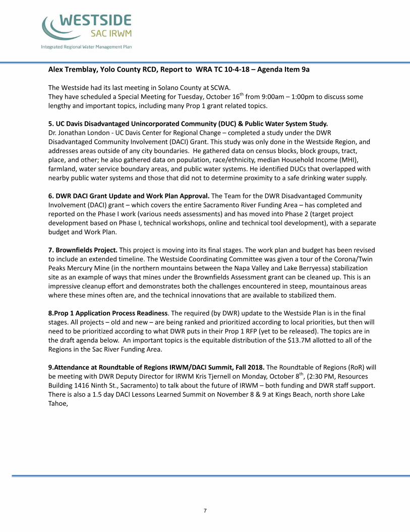
Alex Tremblay, Yolo County RCD, Report to WRA TC 10-4-18 – Agenda Item 9a The Westside had its last meeting in Solano County at SCWA. They have scheduled a Special Meeting for Tuesday, October 16th from 9:00am – 1:00pm to discuss some lengthy and important topics, including many Prop 1 grant related topics. 5. UC Davis Disadvantaged Unincorporated Community (DUC) & Public Water System Study. Dr. Jonathan London - UC Davis Center for Regional Change – completed a study under the DWR Disadvantaged Community Involvement (DACI) Grant. This study was only done in the Westside Region, and addresses areas outside of any city boundaries. He gathered data on census blocks, block groups, tract, place, and other; he also gathered data on population, race/ethnicity, median Household Income (MHI), farmland, water service boundary areas, and public water systems. He identified DUCs that overlapped with nearby public water systems and those that did not to determine proximity to a safe drinking water supply. 6. DWR DACI Grant Update and Work Plan Approval. The Team for the DWR Disadvantaged Community Involvement (DACI) grant – which covers the entire Sacramento River Funding Area – has completed and reported on the Phase I work (various needs assessments) and has moved into Phase 2 (target project development based on Phase I, technical workshops, online and technical tool development), with a separate budget and Work Plan. 7. Brownfields Project. This project is moving into its final stages. The work plan and budget has been revised to include an extended timeline. The Westside Coordinating Committee was given a tour of the Corona/Twin Peaks Mercury Mine (in the northern mountains between the Napa Valley and Lake Berryessa) stabilization site as an example of ways that mines under the Brownfields Assessment grant can be cleaned up. This is an impressive cleanup effort and demonstrates both the challenges encountered in steep, mountainous areas where these mines often are, and the technical innovations that are available to stabilized them. 8.Prop 1 Application Process Readiness. The required (by DWR) update to the Westside Plan is in the final stages. All projects – old and new – are being ranked and prioritized according to local priorities, but then will need to be prioritized according to what DWR puts in their Prop 1 RFP (yet to be released). The topics are in the draft agenda below. An important topics is the equitable distribution of the $13.7M allotted to all of the Regions in the Sac River Funding Area. 9.Attendance at Roundtable of Regions IRWM/DACI Summit, Fall 2018. The Roundtable of Regions (RoR) will be meeting with DWR Deputy Director for IRWM Kris Tjernell on Monday, October 8th, (2:30 PM, Resources Building 1416 Ninth St., Sacramento) to talk about the future of IRWM – both funding and DWR staff support. There is also a 1.5 day DACI Lessons Learned Summit on November 8 & 9 at Kings Beach, north shore Lake Tahoe,
7
COORDINATING COMMITTEE SPECIAL BUSINESS MEETING
Date: Tuesday, October 16th, 2018 Time: 9:00 AM – 1:00 PM Location: Yolo County Flood Control and Water Conservation District office, 34274 State Hwy. 16,
Woodland, CA 95695 Call-in number: 800-510-5879 Guest Code: 385498
AGENDA
1. Call Meeting to Order and Introductions – Sabatini, Chair
2. *** Public Comment: This is time reserved for the public to address the Coordinating Committee on matters not on the agenda
3. * Addition of New Projects by Tribes – Norris (10 min)
4. *Status of the Westside Sacramento IRWM Plan Update – Itagaki (10 min)
5. *Ranking and Prioritization of Westside Projects – Itagaki (10 min)
6. *Funding Priorities in the DWR IRWMP Round 1 Implementation Proposal Solicitation Package (PSP) – Lessard/Burdick
7. *Equitable Distribution of Grant Funds Throughout the Sacramento River Funding Area – Lessard/Burdick
8. *2018-2019 Annual Work Plan Development - Sabatini
9. Adjourn
8
Westside SAC IRWM Projects Submitted - Yolo County
WestsideIRWMPlanUpdate_ProjectSortsForWRA.xlsxBy County
1 of 14
11/30/2018
Project No.
Lead Agency Organization Name of Primary Contact
Project Title Project Description Briefly describe the project in 300 words or less Project Location County
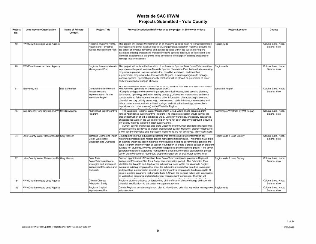
40 RWMG with selected Lead Agency Regional Invasive Plants, Aquatic and Terrestrial Weeds Management Plan
This project will include the formation of an Invasive Species Task Force/Subcommittee to prepare a Regional Invasive Species Management/Eradication Plan that documents the extent of invasive terrestrial and aquatic species within the Westside Region; evaluates existing programs to manage invasive species that could be leveraged, and identifies supplemental programs to be developed to fill gaps in existing programs to manage invasive species.
The documentation phase will include review of existing GIS data and programs of local
Region-wide Colusa, Lake, Napa, Solano, Yolo
76 RWMG with selected Lead Agency Regional Invasive Mussels Management Plan
This project will include the formation of an Invasive Species Task Force/Subcommittee to prepare a Regional Invasive Mussels Species Prevention Plan that evaluates existing programs to prevent invasive species that could be leveraged, and identifies supplemental programs to be developed to fill gaps in existing programs to manage invasive species. Special high priority emphasis will be placed on prevention of water body infestation by Quagga Mussels.
The documentation phase will include review of existing GIS data and programs of local
Region-wide Colusa, Lake, Napa, Solano, Yolo
81 Tuleyome, Inc. Bob Schneider Comprehensive Mercury Assessment and Implementation for the Westside Region
Key Activities (generally in chronological order):• Compile and georeference existing maps, technical reports, land use and planning documents, hydrology and water quality data (e.g., flow rates, mercury and sediment concentrations, fish tissue mercury) and other information characterizing known and potential mercury priority areas (e.g., unmaintained roads, hillsides, streambanks and debris dams, mercury mines, mineral springs, surficial soil mineralogy, atmospheric deposition, and point sources) in the Westside Region.• Monitor mercury biosentinels and fine grain streambed sediments in the Putah Creek
Westside Region Colusa, Lake, Napa, Solano, Yolo
85 Yolo County Flood Control and Wa Max Stevenson Abandoned Well Incentive Program
The Westside Regional Water Management Group would like to create a grant funded Abandoned Well Incentive Program. The Incentive program would pay for the proper destruction of old, abandoned wells. Currently hundreds, or possibly thousands, of abandoned wells in the Westside Region have not been properly destroyed, allowing low quality water to travel to higher quality zones. Current county ordinances and State water well construction standards mandate that unused wells be destroyed to protect groundwater quality. However, properly destroying a well can be expensive and in practice, many wells are not destroyed. Many wells were
b d d d d ith th ibl t l Additi ll th i
Sacramento Westside IRWM Region Colusa, Lake, Napa, Solano, Yolo
94 Lake County Water Resources De Gary Hansen Increase Cache and Putah Creek Watershed Education and Outreach
Develop and improve education programs that provide public with information on watershed programs and related proper management techniques. This program will build on existing water education materials from sources including government agencies, the WET Program and the Water Education Foundation to create a broad education program suitable for students, involved government agencies and the general public. It will cover general principals of watershed management, good environmental stewardship, proper use of area recreational resources, proper management of area water bodies, what homeowners businesses and government can do to promote good management and
Region wide & Lake County Colusa, Lake, Napa, Solano, Yolo
97 Lake County Water Resources De Gary Hansen Form Task Force/Subcommittee to strategize and implement Watershed Education and Outreach
Support appointment of Education Task Force/Subcommittee to prepare a Regional Watershed Education Plan for a 2-year implementation period. The Education Plan identifies the breadth and depth of the educational need within the Westside Region; evaluates existing programs that meet the educational needs that could be leveraged, and identifies supplemental education and/or incentive programs to be developed to fill gaps in existing programs that provide both K-12 and the general public with information on watershed programs and related proper management techniques. The Plan will include an implementation plan for a 2 yr duration after plan development Specific
Region wide & Lake County Colusa, Lake, Napa, Solano, Yolo
134 RWMG with selected Lead Agency Climate Change Adaptation Study
Regional study to advance understanding of the effects of climate change and consider potential modifications to the water management system.
Colusa, Lake, Napa, Solano, Yolo
143 RWMG with selected Lead Agency Regional Capital Improvement Plan
Create Regional asset management plan to identify and prioritize key water management infrastructure.
Region-wide Colusa, Lake, Napa, Solano, Yolo
9
Westside SAC IRWM Projects Submitted
WestsideIRWMPlanUpdate_ProjectSortsForWRA.xlsxBy County
2 of 14
11/30/2018
Project No.
Lead Agency Organization Name of Primary Contact
Project Title Project Description Briefly describe the project in 300 words or less Project Location County
93 Rural Community Assistance Corporation
Brian Phillips Rural Disadvantaged Community (DAC) Partnership Project
RCAC will manage the Prop 84 grant funds to address inadequate water supply and water quality in rural disadvantaged communities (DACs) in the Westside Sacramento IRWM region, including tribal communities, with populations less than 10,000. DACs will be selected based on already recognized income data or completion of an income survey.
RCAC will perform a needs assessment of disadvantaged communities using DWR and Westside Sacramento's DAC mapping tools The assessment will include asking for
Westside Sacramento IRWM Colusa, Lake, Napa, Yolo
126 Yolo County Resource Conservatio Jeanette Wrysinski Implementation of the Cache Creek Watershed Invasive Weed Management Plan
The newly completed Cache Creek Watershed Invasive Weed Management Plan (CCW-IWMP), a living document, identifies specific invasive plants for either eradication, containment or monitoring and prioritizes weeds within those categories. Starting in the upper watershed and working downstream we will use weed mapping information to eradicate those which can be eradicated, contain the edges of those identified in that category, and monitor so as to continually update the plan and re-prioritize and implement vegetation management actions.
Upper Cache Creek Watershed Colusa, Lake, Yolo
39 Solano County Water Agency Alexander A. Rabidoux Source water protection for Putah Creek watershed
This project consists of various improvements such as best management practices, source water protection, reduction of in-channel erosion, improved stream channel geomorphology, remediation of historic mining and others to reduce the impact of point and non-point sources that could negatively impact the Putah Creek watershed, as well as the Yolo Bypass.
Putah Creek Watershed Lake, Napa, Solano, and Yolo
26 Solano County Water Agency Alexander A. Rabidoux Improvements to Solano Project Facilities
The Solano Project was constructed by the US Bureau of Reclamation in the 1950s and is comprised of Monticello Dam, Putah Diversion Dam, Putah South Canal, and Terminal Reservoir. Today, the project provides irrigation and municipal water to over 400,000 people in Solano County. However, the Solano Project is 60 years old and is in need of upgrades, repairs, and modernization.
Solano Project facilities are located in Napa, Solano, and Yolo counties.
Napa, Solano, Yolo counties
30 Solano County Water Agency Thomas Pate North Bay Aqueduct Alternate Intake Project
The California Department of Water Resources proposes to implement the North Bay Aqueduct (NBA) Alternate Intake Project (NBA AIP) to improve water quality and reliability of State Water Project deliveries to its NBA contractors, the Solano County Water Agency and the Napa County Flood Control and Water Conservation District. The NBA AIP includes the construction and operation of a new intake and pumping plant on the Sacramento River, conveyance pipeline, and inline storage to divert and convey water from the Sacramento River connecting to the existing NBA pipeline near the North Bay Regional Water Treatment Plant in Fairfield
Sacramento, Yolo, and Solano Counties Sacramento, Solan, Yolo
83 West Sacramento Area Flood Con Dave Shpak Lower Sacramento and Delta North Regional Flood Management Plan
The Central Valley Flood Protection Plan (CVFPP) calls for State of California Department of Water Resources (DWR) to work with local flood management agencies to prepare detailed Regional Flood Management Plans (RFMP) that, at a minimum, identify and articulate the following:
• Describe flood management challenges and deficiencies at the regional level including operations and maintenance practices, levee and channel inspection, and emergency response plans
Yolo, Solano, Sacramento and parts of Sutt Sacramento, Solano, Sutter, Yolo
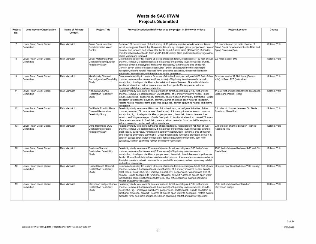
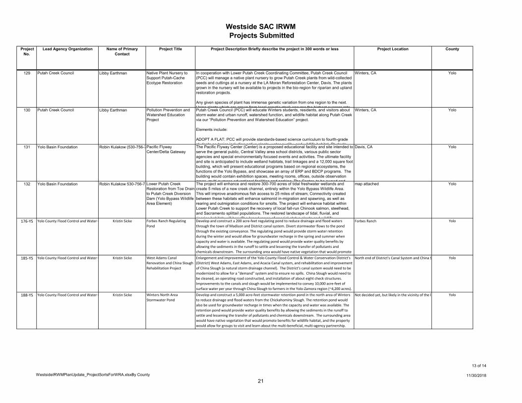
2 Lower Putah Creek Coord. Committee
Rich Marovich 505-East Channel Restoration
Restore 10 acres of riparian forest, 3/4 mile of river channel, remove 22 occurrences (2 net acres) of 6 primary invasive weeds: arundo, eucalyptus,Himalayan blackberry, tree of heaven, fig and tamarisk; reconfigure one thousand feet of river channel, restore 100 feet of eroding streambank, create 3/4 mile of south bank bench trail connecting Yolo Housing to the City of Winters at low flows.
3/4 mile of river channel along south bank east of Highway 505
Solano, Yolo
5 Lower Putah Creek Coord. Committee
Rich Marovich Duncan-Giovannoni Channel Restoration Feasibility Study
Determine feasibility to restore 80 acres of riparian forest, reconfigure one mile of river channel, remove 96 occurrences (7 net acres) of 5 primary invasive weeds: arundo, Himalayan blackberry, tree of heaven, fig and tree tobacco. Convert five acres of excess open water (gravel pit captured by the channel) to floodplain, restore natural meander form, pool-riffle sequence, functional floodplain elevations, salmon spawning habitat and native vegetation.
1 mile of river channel mostly upstream of the Dry Creek Confluence.
Solano, Yolo
6 Lower Putah Creek Coord. Committee
Rich Marovich Glide Ranch Channel Restoration Feasibility Study
Feasibility study to restore 160 acres of riparian forest, reconfigure 11,250 feet of river channel, remove 128 occurrences (8 net acres) of 8 primary invasive weeds: arundo, black locust, eucalyptus, fig, Himalayan blackberry, pepperweed, tamarisk and tree of heaven. Grade floodplain to functional elevation, convert 15 acres of excess open water to floodplain, restore natural meander form, pool-riffle sequence, salmon spawning habitat and native vegetation.
11,258 feet of channel between Stevenson Bridge and Pedrick Road
Solano, Yolo
10
Westside SAC IRWM Projects Submitted
WestsideIRWMPlanUpdate_ProjectSortsForWRA.xlsxBy County
3 of 14
11/30/2018
Project No.
Lead Agency Organization Name of Primary Contact
Project Title Project Description Briefly describe the project in 300 words or less Project Location County
7 Lower Putah Creek Coord. Committee
Rich Marovich Putah Creek Interdam Reach Invasive Weed Control
Remove 127 occurrences (8.6 net acres) of 11 primary invasive weeds: arundo, black locust, eucalyptus, fennel, fig, Himalayan blackberry, pampas grass, pepperweed, tree of heaven, tree tobacco and yellow star thistle from 6.5 river miles (400 acres) of riparian corridor between Monticello Dam and Putah Diversion Dam and install native vegetation where weeds are removed.
6.5 river miles on the main channel of Putah Creek between Monticello Dam and Putah Diversion Dam
Solano, Yolo
8 Lower Putah Creek Coord. Committee
Rich Marovich Lower McNamara Pool Channel Reconfiguration Feasibility Study
Determine feasibility to: restore 25 acres of riparian forest, reconfigure 3,150 feet of river channel, remove 25 occurrences (0.5 net acres) of 6 primary invasive weeds: arundo, domestic almond, eucalyptus, Himalayan blackberry, tamarisk and tree of heaven. Convert seven acres of excess open water (gravel pit captured by the channel) to floodplain, restore natural meander form, pool-riffle sequence, functional floodplain elevations, salmon spawning habitat and native vegetation.
2.5 miles east of 505 Solano, Yolo
9 Lower Putah Creek Coord. Committee
Rich Marovich MacQuiddy Channel Reconfiguration Feasibility Study
Determine feasibility to: restore 34 acres of riparian forest, reconfigure 3,800 feet of river channel, remove 44 occurrences (6 net acres) of 5 primary invasive weeds: arundo, eucalyptus, Himalayan blackberry, tamarisk and tree of heaven. Grade floodplain to functional elevation, restore natural meander form, pool-riffle sequence, salmon spawning habitat and native vegetation.
34 acres west of McNeil Lane (Solano side) or Road 92F (Yolo side)
Solano, Yolo
11 Lower Putah Creek Coord. Committee
Rich Marovich Nishikawa Channel Restoration Feasibility Study
Feasibility study to restore 37 acres of riparian forest, reconfigure 2,430 feet of river channel, remove 20 occurrences (1.36 net acres) of 6 primary invasive weeds: black locust, eucalyptus, pepperweed, tamarisk, tree of heaven and yellow star thistle. Grade floodplain to functional elevation, convert 3 acres of excess open water to floodplain, restore natural meander form, pool-riffle sequence, salmon spawning habitat and native vegetation.
11,258 feet of channel between Stevenson Bridge and Pedrick Road
Solano, Yolo
12 Lower Putah Creek Coord. Committee
Rich Marovich Old Davis Road to Mace Channel Restoration Feasibility Study
Feasibility study to restore 190 acres of riparian forest, reconfigure 3.4 miles of river channel, remove 172 occurrences (5 net acres) of 9 primary invasive weeds: arundo, eucalyptus, fig, Himalayan blackberry, pepperweed, tamarisk, tree of heaven, tree tobacco and Virginia creeper. Grade floodplain to functional elevation, convert 27 acres of excess open water to floodplain, restore natural meander form, pool-riffle sequence, salmon spawning habitat and native vegetation.
3.4 miles of channel between Old Davis Road and Mace Blvd
Solano, Yolo
13 Lower Putah Creek Coord. Committee
Rich Marovich Olmo-Hammond-UCD Channel Restoration Feasibility Study
Feasibility study to restore 109 acres of riparian forest, reconfigure 9,765 feet of river channel, remove 70 occurrences (2.5 net acres) of 9 primary invasive weeds: arundo, black locust, eucalyptus, Himalayan blackberry pepperweed, tamarisk, tree of heaven, tree tobacco and yellow star thistle. Grade floodplain to functional elevation, convert 17 acres of excess open water to floodplain, restore natural meander form, pool-riffle sequence, salmon spawning habitat and native vegetation.
9,765 feet of channel between Pedrick Road and I-80
Solano, Yolo
16 Lower Putah Creek Coord. Committee
Rich Marovich Restoria Channel Restoration Feasibility Study
Feasibility study to restore 93 acres of riparian forest, reconfigure 4,300 feet of river channel, remove 46 occurrences (3.2 net acres) of 6 primary invasive weeds: eucalyptus, Himalayan blackberry, pepperweed, tamarisk, tree tobacco and yellow star thistle. Grade floodplain to functional elevation, convert 2 acres of excess open water to floodplain, restore natural meander form, pool-riffle sequence, salmon spawning habitat and native vegetation.
4300 feet of channel between I-80 and Old Davis Road
Solano, Yolo
18 Lower Putah Creek Coord. Committee
Rich Marovich Russell Ranch Channel Restoration Feasibility Study
Determine feasibility to: restore 50 acres of riparian forest, reconfigure 5,500 feet of river channel, remove 91 occurrences (2.75 net acres) of 8 primary invasive weeds: arundo, black locust, eucalyptus, fig, Himalayan blackberry, pepperweed, tamarisk and tree of heaven. Grade floodplain to functional elevation, convert 7 acres of excess open water to floodplain, restore natural meander form, pool-riffle sequence, salmon spawning habitat and native vegetation.
50 acres near Kinsella Lane (Yolo County) Solano, Yolo
19 Lower Putah Creek Coord. Committee
Rich Marovich Stevenson Bridge Channel Restoration Feasibility Study
Feasibility study to restore 22 acres of riparian forest, reconfigure 2,100 feet of river channel, remove 29 occurrences (0.5 net acres) of 6 primary invasive weeds: arundo, eucalyptus, fig, Himalayan blackberry, pepperweed, and tamarisk. Grade floodplain to functional elevation, convert 1.5 acres of excess open water to floodplain, restore natural meander form, pool-riffle sequence, salmon spawning habitat and native vegetation.
2100 feet of channel centered on Stevenson Bridge
Solano, Yolo
11
Westside SAC IRWM Projects Submitted
WestsideIRWMPlanUpdate_ProjectSortsForWRA.xlsxBy County
4 of 14
11/30/2018
Project No.
Lead Agency Organization Name of Primary Contact
Project Title Project Description Briefly describe the project in 300 words or less Project Location County
21 Lower Putah Creek Coord. Committee
Rich Marovich Upper McNamara Pool Channel Reconfiguration Feasibility Study
Determine feasibility to restore 30 acres of riparian forest, reconfigure 3,300 feet of river channel, remove 52 occurrences (4 net acres) of 7 primary invasive weeds: arundo, catalpa, domestic almond, eucalyptus, Himalayan blackberry, tamarisk and yellow star thistle. Convert five acres of excess open water (gravel pit captured by the channel) to floodplain, restore natural meander form, pool-riffle sequence, functional floodplain elevations, salmon spawning habitat and native vegetation.
1.5 miles east of 505 where Putah Creek Road bends sharply south
Solano, Yolo
33 Solano County Water Agency Alexander A. Rabidoux Research on Hydrodynamics and WQ Interactions in the Delta.
The Sacramento - San Joaquin Delta is a complex array of streams, tidal channels, and estuary mixing with the San Francisco Bay. With large projects such as the Bay Delta Conservation Plan, restoration of thousands of acres of tidal marsh habitat as part of the Delta Biological Opinions, and others, there is a need to better understand the hydrodynamic and water quality interactions in the Delta. Such modeling and monitoring can help Delta users protect ESA species, improve water quality, and maintain water supply for municipal and agricultural users within the Delta.
Sacramento - San Joaquin Delta, with a focus on the Cache Slough Complex
Solano, Yolo
35 Solano County Water Agency Alexander A. Rabidoux Risk Assessment of Delta Water Supplies
This project would entail a risk assessment of Delta Water supplies, and would look at the impacts of unforseen circumstances such as:- Earthquakes- Delta levee failure- Sea level rise- and others as neededThe study would determine the risks and potential impacts to Delta water supplies such as the NBA The project would inform and educate Delta and NBA water users
Sacramento - San Joaquin Delta Solano, Yolo
38 Solano County Water Agency Alexander A. Rabidoux Source water protection for Delta water sources
This project consists of various improvements such as best management practices, source water protection, and others to reduce the impact of point and non-point sources that could negatively impact Delta water quality, with a particular emphasis on drinking water quality.
Sacramento - San Joaquin Delta Solano, Yolo
43 Solano County Water Agency Alexander A. Rabidoux Wetland Restoration Research and Impacts to Source Water Quality.
The project will consist of scientific study/research on wetland restoration, organic carbon generation, and other important areas of study, to determine the corresponding impacts on municipal source water quality. The study will address many of the concerns associated with large scale wetland restoration in the Suisun Marsh and Cache Slough Complex.
Sacramento - San Joaquin Delta Solano, Yolo
112 West Sacramento Area Flood Control Agency
Michael Bessette, P.E. Deep Water Ship Canal Navigation Levee Repair
Correct deficiencies, protect against underseepage, and maintain the Deep Water Ship Canal Levees to current standards for FEMA 100 yr and urban levee 200 year levels of flood protection. Physical improvements may include, but not be limited to, restoration and armoring of water-side levee slopes, increased levee height through crown raising or crown-top walls, slurry cutoff walls in the levee prism, seepage blankets on the levee land-side, levee setbacks, etc.
Solano, Yolo
114 West Sacramento Area Flood Control Agency
Michael Bessette, P.E. Sacramento River Levee Repair
Correct deficiencies, protect against underseepage, and maintain the Sacramento River Levees to current standards for FEMA 100 yr and SB 5 200 year levels of flood protection. Physical improvements may include, but not be limited to, restoration and armoring of water-side levee slopes, increased levee height through crown raising or crown-top walls, slurry cutoff walls in the levee prism, seepage blankets on the levee land-side levee setbacks etc
Right bank of the Sacramento River from approximately River Mile 63.0 to approximately River Mile 46.0
Solano, Yolo
116 West Sacramento Area Flood Control Agency
Michael Bessette, P.E. Sacramento Bypass-Yolo Bypass Levee Repair Phase II
Correct deficiencies, protect against underseepage, and maintain the Sacramento Bypass and Yolo Bypass Levees to current standards for FEMA 100 yr and urban levee 200 year levels of flood protection. Physical improvements may include, but not be limited to, restoration and armoring of water-side levee slopes, increased levee height through crown raising or crown-top walls, slurry cutoff walls in the levee prism, seepage blankets on the levee land-side, levee setbacks, etc.
Solano, Yolo
1 West Sacramento Area Flood Control Agency
Michael Bessette, P.E. Bees Lakes Preserve Conserve and develop limited, low-impact pedestrian-only recreational access to a 23-acre open space area containing sensitive aquatic, riparian, emergent and upland habitats which are associated with the Sacramento River.
Yolo
3 Lower Putah Creek Coord. Committee
Rich Marovich Apricot Draw Bank Stabilization
Restores 3,000 feet of Apricot Draw, stabilizing eroding banks, removing invasive weeds and planting native vegetation.
3,000 feet of Apricot Draw to confluence with Putah Creek at Lake Solano
Yolo
4 Lower Putah Creek Coord. Committee
Rich Marovich Dry Creek Wildlife Migration Corridor
Feasibility study to restore 2 miles of wildlife corridor from the confluence of Putah Creek along Dry Creek on the western boundary of Winters
2 miles of Dry Creek above the confluence with Putah Creek inclusive.
Yolo
12
Westside SAC IRWM Projects Submitted
WestsideIRWMPlanUpdate_ProjectSortsForWRA.xlsxBy County
5 of 14
11/30/2018
Project No.
Lead Agency Organization Name of Primary Contact
Project Title Project Description Briefly describe the project in 300 words or less Project Location County
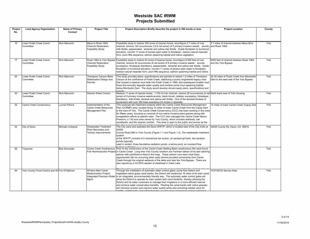
10 Lower Putah Creek Coord. Committee
Rich Marovich Mace to Road 106A Channel Restoration Feasibility Study
Feasibility study to restore 305 acres of riparian forest, reconfigure 2.7 miles of river channel, remove 124 occurrences (12.8 net acres) of 5 primary invasive weeds: arundo, milk thistle, pepperweed, tamarisk and yellow star thistle. Grade floodplain to functional elevation, convert 17 acres of excess open water to floodplain, restore natural meander form, pool-riffle sequence, salmon spawning habitat and native vegetation.
2.7 miles of channel between Mace Blvd and Road 106A
Yolo
17 Lower Putah Creek Coord. Committee
Rich Marovich Road 106A to Yolo Bypass Channel Restoration Feasibility Study
Feasibility study to restore 52 acres of riparian forest, reconfigure 6,000 feet of river channel, remove 42 occurrences (8 net acres) of 6 primary invasive weeds: arundo, eucalyptus, Himalayan blackberry, pepperweed, tamarisk and yellow star thistle. Grade floodplain to functional elevation, convert 11 acres of excess open water to floodplain, restore natural meander form, pool-riffle sequence, salmon spawning habitat and native vegetation
6000 feet of channel between Road 106A and the Yolo Bypass
Yolo
20 Lower Putah Creek Coord. Committee
Rich Marovich Thompson Canyon Bank Stabilization Design and Permits
This study provides plans, specifications and permits to restore 1.5 miles of Thompson Canyon at the confluence of Putah Creek, stabilizing a poorly engineered legacy road that caused a massive mud slide into Putah Creek in 1995; and subsequent smaller mud flows that annually degrade water quality and smother prime trout spawning habitat below Monticello Dam. The study would develop shovel-ready plans, specifications and permits
All 30 miles of Putah Creek from Monticello Dam to the west wall of the Yolo Bypass
Yolo
22 Lower Putah Creek Coord. Committee
Rich Marovich Warren Weed Control Restore 11 acres of riparian forest, 1,700 of river channel, remove 26 occurrences (2 net acres) of 8 primary invasive weeds:arundo, black locust, catalpa, eucalyptus, Himalayan blackberry, milk thistle, tamarsk and yellow star thistle. One of the densest thickets of eucalyptus with over 300 trees averaging 24 inches in diameter.
North bank east of Yolo Housing Yolo
52 Cache Creek Conservancy Lynnel Pollock Implementation of the Cache Creek Resources Management Plan
This proposal will implement projects within the Cache Creek Resources Management Plan (CCRMP) area, located along 15 miles of lower Cache Creek from the Capay Dam to the town of Yolo. The Cache Creek Conservancy (CCC) has been working in this area for fifteen years, focusing on removal of non-native invasive plant species along with revegetation efforts at specific sites. The CCC also manages the Cache Creek Nature Preserve, a 130 acre area owned by Yolo County, which includes wetlands, oak woodlands, and the riparian corridor. This area is open to the public and serves as the site of our environmental education program outreach activities for people of all ages
15 miles of lower Cache Creek (Capay Dam Yolo
54 City of Davis Michael Lindquist Wastewater Treatment Plant Secondary and Tertiary Improvements
The City owns and operates the Davis WWTP, which is located east of the City limits at 45400County Road 28H in Yolo County (Figure 1-1 and Figure 1-2). The wastewater treatment systemat the WWTP consists of a mechanical bar screen, an aerated grit tank, two aeration ponds (typicallyused in winter), three facultative oxidation ponds, a lemna pond, an overland flow system a chlorine
45400 County Rd, Davis, CA 95616 Yolo
80 Tuleyome Bob Schneider Cache Creek Anadramous Fish Reintroduction Project
Prior to the construction of the Cache Creek Settling Basin anadromous fish were found in Cache Creek. Long time Yolo County resident Joe Farnham talked of his dad catching salmon with pitchforks to feed to the hogs. These salmon runs were most likely opportunistic fall run occurring when early storms provided connectivity from Cache Creek through the original wetlands of the delta and later the Yolo Bypass. There are also reports by a CA DFG warden of steelhead in Clear Lake.
This four phase project will study the opportunity and constraints for the reintroduction to
Yolo
84 Yolo County Flood Control and Wa Tim O'Halloran Winters Main Canal Modernization Project: Integrated Precision Water Mgmt.
Through the installation of automatic water control gates, pump flow meters and vegetated native grass canal banks, the District will modernize 16 miles of its main canal in an integrated, environmentally friendly way. The automatic water control gates will allow the District to operate its main system with more flexibility, thereby allowing the District and its water customers to manage their irrigations in a more efficient manner and achieve water conservation benefits. Planting the canal banks with native grasses will minimize erosion and improve water quality while also providing habitat value for wildlife Additionally converting from the use of a spray program to control undesired
YCFCWCD Service Area Yolo
13
Westside SAC IRWM Projects Submitted
WestsideIRWMPlanUpdate_ProjectSortsForWRA.xlsxBy County
6 of 14
11/30/2018
Project No.
Lead Agency Organization Name of Primary Contact
Project Title Project Description Briefly describe the project in 300 words or less Project Location County
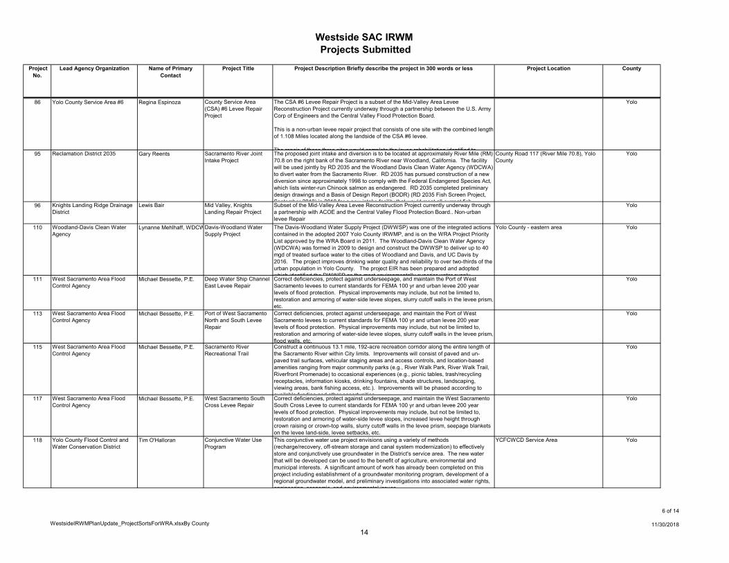
86 Yolo County Service Area #6 Regina Espinoza County Service Area (CSA) #6 Levee Repair Project
The CSA #6 Levee Repair Project is a subset of the Mid-Valley Area Levee Reconstruction Project currently underway through a partnership between the U.S. Army Corp of Engineers and the Central Valley Flood Protection Board.
This is a non-urban levee repair project that consists of one site with the combined length of 1.108 Miles located along the landside of the CSA #6 levee.
The repair of these three sites would complete the levee rehabilitation identified to
Yolo
95 Reclamation District 2035 Gary Reents Sacramento River Joint Intake Project
The proposed joint intake and diversion is to be located at approximately River Mile (RM) 70.8 on the right bank of the Sacramento River near Woodland, California. The facility will be used jointly by RD 2035 and the Woodland Davis Clean Water Agency (WDCWA) to divert water from the Sacramento River. RD 2035 has pursued construction of a new diversion since approximately 1998 to comply with the Federal Endangered Species Act, which lists winter-run Chinook salmon as endangered. RD 2035 completed preliminary design drawings and a Basis of Design Report (BODR) (RD 2035 Fish Screen Project, September 2010) in 2010 for a new intake facility that would meet all current fish
County Road 117 (River Mile 70.8), Yolo County
Yolo
96 Knights Landing Ridge Drainage District
Lewis Bair Mid Valley, Knights Landing Repair Project
Subset of the Mid-Valley Area Levee Reconstruction Project currently underway through a partnership with ACOE and the Central Valley Flood Protection Board.. Non-urban levee Repair
Yolo
110 Woodland-Davis Clean Water Agency
Lynanne Mehlhaff, WDCW Davis-Woodland Water Supply Project
The Davis-Woodland Water Supply Project (DWWSP) was one of the integrated actions contained in the adopted 2007 Yolo County IRWMP, and is on the WRA Project Priority List approved by the WRA Board in 2011. The Woodland-Davis Clean Water Agency (WDCWA) was formed in 2009 to design and construct the DWWSP to deliver up to 40 mgd of treated surface water to the cities of Woodland and Davis, and UC Davis by 2016. The project improves drinking water quality and reliability to over two-thirds of the urban population in Yolo County. The project EIR has been prepared and adopted which identified the DWWSP as the most environmentally superior water supply
Yolo County - eastern area Yolo
111 West Sacramento Area Flood Control Agency
Michael Bessette, P.E. Deep Water Ship Channel East Levee Repair
Correct deficiencies, protect against underseepage, and maintain the Port of West Sacramento levees to current standards for FEMA 100 yr and urban levee 200 year levels of flood protection. Physical improvements may include, but not be limited to, restoration and armoring of water-side levee slopes, slurry cutoff walls in the levee prism, etc.
Yolo
113 West Sacramento Area Flood Control Agency
Michael Bessette, P.E. Port of West Sacramento North and South Levee Repair
Correct deficiencies, protect against underseepage, and maintain the Port of West Sacramento levees to current standards for FEMA 100 yr and urban levee 200 year levels of flood protection. Physical improvements may include, but not be limited to, restoration and armoring of water-side levee slopes, slurry cutoff walls in the levee prism, flood walls, etc.
Yolo
115 West Sacramento Area Flood Control Agency
Michael Bessette, P.E. Sacramento River Recreational Trail
Construct a continuous 13.1 mile, 192-acre recreation corridor along the entire length of the Sacramento River within City limits. Improvements will consist of paved and un-paved trail surfaces, vehicular staging areas and access controls, and location-based amenities ranging from major community parks (e.g., River Walk Park, River Walk Trail, Riverfront Promenade) to occasional experiences (e.g., picnic tables, trash/recycling receptacles, information kiosks, drinking fountains, shade structures, landscaping, viewing areas, bank fishing access, etc.). Improvements will be phased according to available funding and other opportunities
Yolo
117 West Sacramento Area Flood Control Agency
Michael Bessette, P.E. West Sacramento South Cross Levee Repair
Correct deficiencies, protect against underseepage, and maintain the West Sacramento South Cross Levee to current standards for FEMA 100 yr and urban levee 200 year levels of flood protection. Physical improvements may include, but not be limited to, restoration and armoring of water-side levee slopes, increased levee height through crown raising or crown-top walls, slurry cutoff walls in the levee prism, seepage blankets on the levee land-side, levee setbacks, etc.
Yolo
118 Yolo County Flood Control and Water Conservation District
Tim O'Halloran Conjunctive Water Use Program
This conjunctive water use project envisions using a variety of methods (recharge/recovery, off-stream storage and canal system modernization) to effectively store and conjunctively use groundwater in the District's service area. The new water that will be developed can be used to the benefit of agriculture, environmental and municipal interests. A significant amount of work has already been completed on this project including establishment of a groundwater monitoring program, development of a regional groundwater model, and preliminary investigations into associated water rights, engineering economic and environmental issues
YCFCWCD Service Area Yolo
14
Westside SAC IRWM Projects Submitted
WestsideIRWMPlanUpdate_ProjectSortsForWRA.xlsxBy County
7 of 14
11/30/2018
Project No.
Lead Agency Organization Name of Primary Contact
Project Title Project Description Briefly describe the project in 300 words or less Project Location County
119 Yolo County Flood Control and Water Conservation District
Tim O'Halloran Moore Siphon Reliability/Restoration Project
The Moore Siphon conveys irrigation water from the north side of Cache Creek (Alder Canal) to the south side (Moore Canal). Through the Moore Siphon, YCFCWCD delivers water to approximately 15,000 acres of cropland (12% of its irrigation service area). This water also makes a significant recharge contribution to the City of Woodland's groundwater supply. Due to the age and exposure of the 72" corrugated metal pipe, as well as Cache Creek erosion issues at both ends of the siphon, the siphon well either need to be replaced or rehabilitated in the near future.
YCFCWCD Service Area Yolo
120 Yolo County Wes Ervin Yolo County Airport Drainage Plan
The Yolo County Airport, located just West of Davis, consists of 498 acres being used as a publicly owned general aviation airport. Prior to downstream drainage changes restricting the outlet at the southeastern corner of the property, on-site runoff caused only minor flooding. Now, however, areas on the east side of the property flood during certain storm events. Flooding in the low-lying areas occur fairly regularly. In order for the airport to eliminate flooding of its facilities and to expand, a 2005 Drainage Plan engineered by Wood Rogers needs to be implemented.
Yolo County Airport Yolo
121 Yolo County Cindy Tuttle Analysis of BDCP's Yolo Bypass Conservation Measure and Other Measures
As a result of Biological Opinion requirements and science indicating benefits of flooding the Yolo Bypass for fish habitat, the November 2010 Bay Delta Conservation Plan (BDCP) Working Draft proposed a conservation measure that includes, among other things, modification of the Fremont Weir and possibly other structures to increase the frequency and duration of flooding in the Yolo Bypass. In response to this draft and earlier iterations of the conservation measure, Yolo County requested an analysis of the impacts of the conservation measure, including flood protection impacts. Given the importance of the Yolo Bypass in protecting the Sacramento area from flooding the
Yolo Bypass, Yolo County, California Yolo
122 Yolo County, Natural Resources Division
Cindy Tuttle Cache Creek Parkway Plan
The Cache Creek Parkway Plan is in the early stages of development. Once complete the Plan will result in a comprehensive planning document that will guide the restoration and ultimate uses of County owned lands within the Cache Creek Area Plan boundary. The Plan will leave the citizens of Yolo County with a legacy of open space parks and nature preserves along Cache Creek and will provide well-managed opportunities for public access, education, and recreation. The Parkway Plan will provide a detailed vision and integrated management plan for all of the properties (1,537 acres total), plus any others accepted or purchased for management under the Cache Creek Area Plan
Lower Cache Creek ( approx. 15 miles, from Capay Dam to town of Yolo)
Yolo
123 Yolo County Cindy Tuttle Clarksburg Flood Protection Feasibility Study
The project involves conducting a feasibility study of alternatives to provide a 100-year level of flood protection to the Clarksburg region, located largely in the primary zone of the Sacramento River Delta within the County of Yolo (a small portion of the region is located in the secondary zone). The study will also include analysis of alternatives for interim flood management solutions to protect areas suitable for the development of agricultural processing facilities. Yolo County will work with Reclamation District 999 and contract with outside technical experts to undertake this study.
Clarksburg Region of Yolo County Yolo
124 Yolo County Parks Jen Santos Lower Cache Creek Campground and Habitat Restoration
The project involves the construction of approximately 9 new camp sites and potentially 9 rural campsites at the Yolo County Lower Cache Creek Park site as well as restoration of significant riparian and upland environments. The project also proposes to install a park host space, a water well to support the parks host, park visitors and newly planted restoration.
1479 Highway !6, Rumsey, CA 95679 Yolo
125 Yolo County Cindy Tuttle Methylmercury Impacts Analyses for the Yolo Bypass
Full Name of Proposed Project: Methylmercury Impacts Analyses of the Proposed Yolo Bypass Fisheries Enhancement Project and Yolo Bypass Expansion Project
Yolo County proposes to collect data and analyze changes in methylmercury production and bioaccumulation that could result from (1) a proposed Bay Delta Conservation Plan (BDCP) project to enhance fisheries habitat in the Yolo Bypass; and (2) a Central Valley Flood Protection Plan proposal to expand the Yolo Bypass to improve flood capacity. Both projects may increase the methylmercury levels in fish tissue and increase related
Yolo Bypass, Yolo County, California Yolo
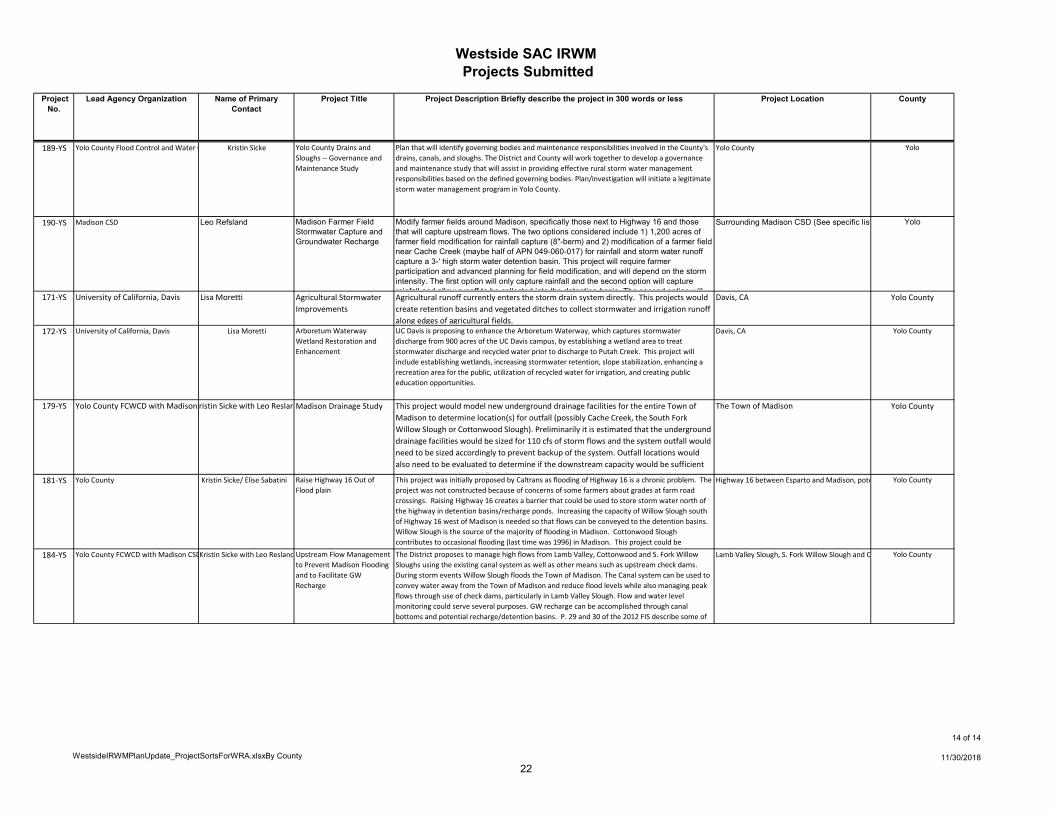
127 Yolo County Resource Conservatio Jeanette Wrysinski Agricultural Drain, Slough and Canal Riparian Habitat Enhancement
Control of invasive weeds, site preparation, installation of native trees, shrubs, grasses and/or forbs as appropriate to the site, and 2 years of vegetation management/ maintenance post-plant along natural and man-made waterways, with focus on Cottonwood, Union School, Willow and Chickahominy sloughs; and main irrigation supply canals in western Yolo County.
Yolo
15
Westside SAC IRWM Projects Submitted
WestsideIRWMPlanUpdate_ProjectSortsForWRA.xlsxBy County
8 of 14
11/30/2018
Project No.
Lead Agency Organization Name of Primary Contact
Project Title Project Description Briefly describe the project in 300 words or less Project Location County
133 Yolo Basin Foundation Robin Kulakow (530-756-7 Yolo Bypass Wildlife Area Public Use Improvements
The Yolo Bypass Wildlife Area Land Management Plan (LMP) has an “authorized” public use element that outlines tasks associated with improving wildlife viewing, fish and hunting. This proposal would complete some of the tasks related to enhancement of public use infrastructure.To maintain and improve wildlife observation (LMP, 5-34)• Expand existing northern auto tour route to encompass portions of the Causeway Ranch and adjacent units. • Develop a new southern auto tour route on the Tule Ranch
map attached Yolo
135 Reclamation District 2035 Regina Cherovsky Tule Canal Habitat Enhancement & Sediment Removal
The project consists of:1. Securing an environmental easement that would protect valuable floodplain habitat and adjacent lands from other uses;2. Construction of operational facilities for water control and fish passage;3. Regrading portions of the floodplain habitat to increase the quality of seasonally inundation based on managed flows from the Sacramento River
Yolo
136 Reclamation District 2035 Regina Cherovsky Levee Repairs/Maintenance- Segments 150, 173 and 297
Complete geological analysis, engineering design required to identify and correct levee deficiencies and hazard mitigation recommendations contained in the URS levee evaluation report (2010) completed at the direction of the Department of Water Resources and additional geologic investigation analysis (to be completed) recommendations.
Yolo
137 Reclamation District 2035 Regina Cherovsky Installation of Groundwater Wells
Engineer, design and install groundwater wells. Yolo
138 Reclamation District 2035 Regina Cherovsky Groundwater Studies Reclamation District 2035's Ground Studies Project will consist of the identification and analysis of issues, if any, surrounding the quality and availability of groundwater.
Yolo
139 Reclamation District 2035 Regina Cherovsky Floodway Corridor Project The project consists of three major phases/components:
1. Acquisition of Conservation/Flowage Easements - Approx. 7,000 acres.2. New Sacramento River By Pass - A new bypass facility will be constructed to divert flows from the Sac River to the Yolo Bypass. During large storm evens flood flows would be diverted (Sac River) over a new weir to a new bypass channel that would deliver flows to the Yolo Bypass.3 Diverting additional flood flows in to the Yolo Bypass would increase flow and stages
Yolo
140 Reclamation District 2035 Regina Cherovsky Cross Bypass Canal Modernization
The project consists of piping (or lining) the Cross Bypass Canal and the installation of flow control and measurement devices to improve the conveyance system and increase water use efficiency.
Yolo
141 Reclamation District 2035 Regina Cherovsky Conjunctive Use Study The project consists of the study and analysis of the coordinated use of surface and groundwater that could benefit the agricultural, urban, and environmental interests within, nearby and downstream of Yolo County, especially the North Delta region.
The project includes seven main elements:1. Data Collection2. Data Analysis and Management3 Field Studies and Testing
Yolo
144 Reclamation District 999 Bob Weber Elk Slough Groundwater Quality Improvement and Flood Protection Project
Elk Slough is the surface water recharge source for the sole-source shallow aquifer providing drinking water for residents of the Delta community of Clarksburg. The slough is currently closed to the fresh water of the Sacramento River and is maintained by tidal inflows from Sutter Slough. Elk Slough water quality is typically similar to that of the river; however, when salinity intrusion increases during droughts, the slough water quality declines. Proposed salinity barriers, Delta Cross Channel reoperations, and Freeport intake operations work in concert to significantly backwater Elk Slough and reduce freshening tidal inflows An operable gate at the slough head would allow for a limited
Yolo
145 City of West Sacramento Dan Mount Municipal Well at the George Kristoff Water Treatment Plant
Project includes environmental, design and construction of a new municipal well located at 400 N.Harbor Blvd in the City of West Sacramento. This well will augment City potable water supplies during drought conditions. This well in not intended to increase water production but allow upstream surface water diversions by as much as 4,500 acre feet annually.
George Kristoff Water Treatment Plant, 400 Yolo
16
Westside SAC IRWM Projects Submitted
WestsideIRWMPlanUpdate_ProjectSortsForWRA.xlsxBy County
9 of 14
11/30/2018
Project No.
Lead Agency Organization Name of Primary Contact
Project Title Project Description Briefly describe the project in 300 words or less Project Location County
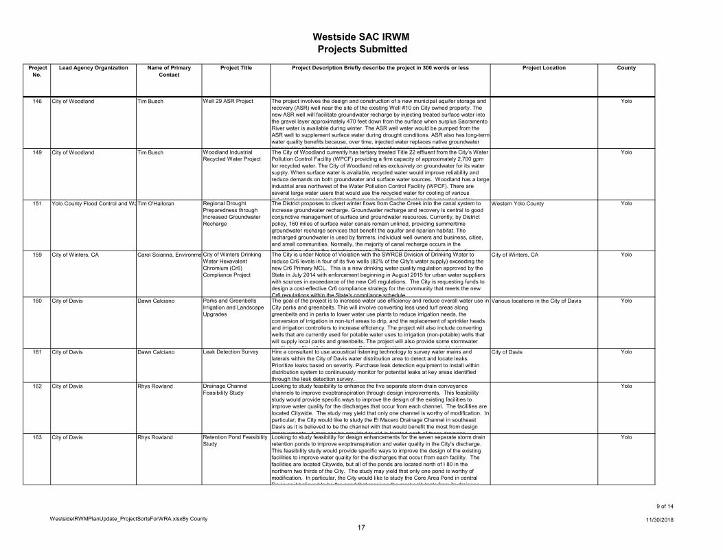
146 City of Woodland Tim Busch Well 29 ASR Project The project involves the design and construction of a new municipal aquifer storage and recovery (ASR) well near the site of the existing Well #10 on City owned property. The new ASR well will facilitate groundwater recharge by injecting treated surface water into the gravel layer approximately 470 feet down from the surface when surplus Sacramento River water is available during winter. The ASR well water would be pumped from the ASR well to supplement surface water during drought conditions. ASR also has long-term water quality benefits because, over time, injected water replaces native groundwater impaired by nitrate and naturally occurring metallic species including arsenic
Yolo
149 City of Woodland Tim Busch Woodland Industrial Recycled Water Project
The City of Woodland currently has tertiary treated Title 22 effluent from the City’s Water Pollution Control Facility (WPCF) providing a firm capacity of approximately 2,700 gpm for recycled water. The City of Woodland relies exclusively on groundwater for its water supply. When surface water is available, recycled water would improve reliability and reduce demands on both groundwater and surface water sources. Woodland has a large industrial area northwest of the Water Pollution Control Facility (WPCF). There are several large water users that would use the recycled water for cooling of various industrial processes In addition there are two City Parks along the recycled water
Yolo
151 Yolo County Flood Control and Wa Tim O'Halloran Regional Drought Preparedness through Increased Groundwater Recharge
The District proposes to divert winter flows from Cache Creek into the canal system to increase groundwater recharge. Groundwater recharge and recovery is central to good conjunctive management of surface and groundwater resources. Currently, by District policy, 160 miles of surface water canals remain unlined, providing summertime groundwater recharge services that benefit the aquifer and riparian habitat. The recharged groundwater is used by farmers, individual well owners and business, cities, and small communities. Normally, the majority of canal recharge occurs in the summertime during the irrigation season This project proposes to divert wintertime
Western Yolo County Yolo
159 City of Winters, CA Carol Scianna, Environme City of Winters Drinking Water Hexavalent Chromium (Cr6) Compliance Project
The City is under Notice of Violation with the SWRCB Division of Drinking Water to reduce Cr6 levels in four of its five wells (82% of the City's water supply) exceeding the new Cr6 Primary MCL. This is a new drinking water quality regulation approved by the State in July 2014 with enforcement beginning in August 2015 for urban water suppliers with sources in exceedance of the new Cr6 regulations. The City is requesting funds to design a cost-effective Cr6 compliance strategy for the community that meets the new Cr6 regulations within the State's compliance schedule.
City of Winters, CA Yolo
160 City of Davis Dawn Calciano Parks and Greenbelts Irrigation and Landscape Upgrades
The goal of the project is to increase water use efficiency and reduce overall water use in City parks and greenbelts. This will involve converting less used turf areas along greenbelts and in parks to lower water use plants to reduce irrigation needs, the conversion of irrigation in non-turf areas to drip, and the replacement of sprinkler heads and irrigation controllers to increase efficiency. The project will also include converting wells that are currently used for potable water uses to irrigation (non-potable) wells that will supply local parks and greenbelts. The project will also provide some stormwater quality benefits with less water runoff in areas that have been converted to drip
Various locations in the City of Davis Yolo
161 City of Davis Dawn Calciano Leak Detection Survey Hire a consultant to use acoustical listening technology to survey water mains and laterals within the City of Davis water distribution area to detect and locate leaks. Prioritize leaks based on severity. Purchase leak detection equipment to install within distribution system to continuously monitor for potential leaks at key areas identified through the leak detection survey.
City of Davis Yolo
162 City of Davis Rhys Rowland Drainage Channel Feasibility Study
Looking to study feasibility to enhance the five separate storm drain conveyance channels to improve evoptranspiration through design improvements. This feasibility study would provide specific ways to improve the design of the existing facilities to improve water quality for the discharges that occur from each channel. The facilities are located Citywide. The study may yield that only one channel is worthy of modification. In particular, the City would like to study the El Macero Drainage Channel in southeast Davis as it is believed to be the channel with that would benefit the most from design improvements A map can be provided to aid in located each of these drainage
Yolo
163 City of Davis Rhys Rowland Retention Pond Feasibility Study
Looking to study feasibility for design enhancements for the seven separate storm drain retention ponds to improve evoptranspiration and water quality in the City's discharge. This feasibility study would provide specific ways to improve the design of the existing facilities to improve water quality for the discharges that occur from each facility. The facilities are located Citywide, but all of the ponds are located north of I 80 in the northern two thirds of the City. The study may yield that only one pond is worthy of modification. In particular, the City would like to study the Core Area Pond in central Davis as it believed to be the pond that receives the most pollutants from its drainage
Yolo
17
Westside SAC IRWM Projects Submitted
WestsideIRWMPlanUpdate_ProjectSortsForWRA.xlsxBy County
10 of 14
11/30/2018
Project No.
Lead Agency Organization Name of Primary Contact
Project Title Project Description Briefly describe the project in 300 words or less Project Location County
164 City of Davis Martin Jones Russel Boulevard Demonstration LID Project
The project is to be located in front of City Hall (already proposed and working its way through the City's Parks and Community Services Department) along Russell Boulevard. Russel Boulevard is one of the City's prominent east-west arterials. The project is to create a vegetated swale to treat stromwater runoff on the north side of the roadway. The surface area it will treat is 8,000 square feet. It is proposed to treat drainage prior to discharge to the City's stormdrain system consistent with the standards of Section E.12 of the State's Small MS4 Phase II General Permit (Permit). A map can be provided to aid in the location of this project
Yolo
167 City of Davis Martin Jones Davis Greenbelts Landscape Conversions
One of the greatest assets to the Davis park system is the network of more than 60 miles of Green Belts with bike trails that connect parks and neighborhoods throughout the City. Each belt is typically between 100 to 200 feet across with an 8-foot bike path meandering through the middle. Most of the landscape consists of irrigated turf and shade trees. Large open turf areas are greatly appreciated as multi-use event areas for local neighbors, but a majority of the space is mostly utilized by the public as aesthetic while passing through on the bike path. It is these spaces that are great candidates to convert existing turf to a low water use drought tolerant landscape with interpretive learning
Various locations in the City of Davis Yolo
168 Davis Joint Unified School District George Parker Harper Junior High Water Conservation Improvements
Frances Harper Junior High School presents a unique opportunity for water conservation through education and the creation of outdoor classrooms. The school serves over 600 students in grades 7 to 9. Located on East Covell Boulevard in Davis, the property is a 45-acre parcel with about 23 acres in active use. Primary improvements for water conservation are proposed to occur at the front and interior of the site. Current landscape at the front of the school includes 2.3 acres of turf that is primarily for the purpose of aesthetics. There are also interior courtyards with underutilized turf panels that total a little over one third of an acre Planned improvements for these areas include
Frances Harper Junior High School, 4000 E Yolo
169 City of Davis Stan Gryczko Recycled Water Projects The City is currently evaluating the feasibility of various uses of recycled water using WWTP effluent. The WWTP is being upgraded allowing the City to produce high quality recycled water meeting Title 22 Standards. This project would be to assist with funding implementation of the chosen recycled water use(s). These uses may include but are not limited to water for: habitat, Yolo County Landfill, City-owned lands south of the WWTP, agricultural users in the area, City municipal uses, and filling stations.
City of Davis Yolo
193 City of Woodland Tim Busch Well 31 ASR Project The project involves the design and construction of a new municipal aquifer storage and recovery (ASR) well #31 near the site of the existing Well #6. The new ASR well will facilitate groundwater recharge by injecting treated surface water into the gravel layer approximately 500 feet below the surface when surplus Sacramento River water is available during winter months. The ASR well water would be pumped from the ASR well to supplement surface water during drought conditions and to meet peak summer demands. ASR also has long-term water quality benefits because injected water replaces native groundwater impaired by nitrate and naturally occurring metallic species including
Yolo
194 City of Woodland Chris Fong, Senior Associ Outfall Channel Culvert Replacement Project
City has a single stormwater discharge location. The outfall is limited by three (3) existing 36" diameter culvert pipes that penetrate a levee road. The existing culverts are limited in that: (a) they are in poor condition and their flap gates have fallen off and (b) within the next few years, based on development, they will be insufficient to handle the amount of City stormwater flows. Plan to the replace the three (3) existing 36" diameter culverts with five (5) 72" diameter ones to accommodate for full City build-out (2035)
CR 22 @ West Levee Road (River Road, ju Yolo
195 City of Woodland Tim Busch Woodland Recycled Water Utility Expansion Project (Phase II)
The City of Woodland currently has tertiary treated Title 22 effluent from the City’s Water Pollution Control Facility (WPCF) providing a firm capacity of approximately 2,700 gpm for recycled water. Woodland has an existing recycled water utility serving 2 City parks and a large industrial user in the industrial area northwest of the Water Pollution Control Facility (WPCF). The City has planned for an expansion of the recycled water utility into the Spring Lake Area of the City and also to serve the planned Woodland Research & Technology Park. There are several existing large water users that would use the recycled water for irrigation of parks and roadside landscaping Businesses in the
Yolo
196 City of Woodland Tim Busch Woodland Recycled Water Utility Expansion Project (Phase III)
The City of Woodland currently has tertiary treated Title 22 effluent from the City’s Water Pollution Control Facility (WPCF) providing a firm capacity of approximately 2,700 gpm for recycled water. Woodland has an existing recycled water utility serving 2 City parks and a large industrial user in the industrial area northwest of the Water Pollution Control Facility (WPCF). The City has planned for an expansion of the recycled water utility into the Sports Park Area of the City and also to serve the planned SP1B and SP1C areas in the City's General Plan. There are several existing large water users that would use the recycled water for irrigation of parks and roadside landscaping In addition recycled
Yolo
18
Westside SAC IRWM Projects Submitted
WestsideIRWMPlanUpdate_ProjectSortsForWRA.xlsxBy County
11 of 14
11/30/2018
Project No.
Lead Agency Organization Name of Primary Contact
Project Title Project Description Briefly describe the project in 300 words or less Project Location County
201 City of Davis John McNerney Davis Wetlands Public Access Improvements
Install user amenities at the Davis Wetlands to enhance educational and passive recreational access. Primary improvements include installation of a permanent vault toilet, observation tower with interpretive panels, and shaded picnic facility.
Davis Wetlands Yolo
202 City of Davis Ginger Hashimoto Davis Manor Neighborhood Green Street Project
The Davis Manor Neighborhood Green Street Project proposes to retrofit the neighborhood with the following greening treatments: -Plant 90 new trees to sequester carbon and reduce energy consumption -Build 40 rain garden planters to serve as new wildlife habitat and capture stormwater-Convert 9,480 sq. ft. of impermeable surfaces into walkable green space to enhance the pedestrian experience -Transform 5,000 sq. ft. area of the neighborhood into the "Green Heart" toserve as a hub for resident gatherings -Replace 3,000 sq. ft. section of street parking area with a permeable surface strip Replace 400 sq ft area of streetscape with new drought tolerant landscaping
Davis Manor Neighborhood of Davis, CA Yolo
203 City of Davis John Alexander Recycled Water Pump Station
With the completion of secondary and tertiary improvements, the City's Wastewater Treatment Plant is now capable of producing tertiary disinfected effluent that meets the requirements of Title 22 of the California Code of Regulations for recycled water. However, a final component of these upgrades is a means of delivering the recycled water produced at the WWTP to potential future customers. New infrastructure is necessary to convey recycled water from the WWTP to potential future customers or to send recycled water to locations within the WWTP property boundary for storage or disposal
Yolo
204 City of Davis John Alexander Sewer Lateral Replacement
The project would replace aging sewer laterals with corrosion and other issues to protect water quality and reduce the potential for accidental sanitary sewer discharges into the stormwater conveyance system. The project would occur City wide over 3 to 4 years.
City wide in Davis Yolo
173-YS City of Davis Rhys Rowland Bike Tunnel Landscaping Redesign for Stormwater Quality Improvement
Redesign the current drainage and landscaping near greenbelt bike tunnels to prevent flooding from stormwater. Assess the top highly-trafficked tunnels with drainage issues within the greenbelt system. Improved drainage would include re-landscaping the areas surrounding these tunnels to prevent flood events and improve stormwater quality discharges through the use of different stormwater low impact design methods through infiltration, transpiration and evaporation. Each site could showcase a different method; signage near the tunnels would illustrate the project and highlight elements of the project design.
Yolo
174-YS City of Davis Rhys Rowland Feasibility Study for Stormwater Trash Control Measures
Feasibility study to assess options for stormwater trash control measures. This study will assess the best method(s) to help the City meet mandatory requirements for trash screening to prevent trash from entering waterways. One particular area of concern is Channel A. An option for this area is to install trash racks/debris cages in the Wildhorse Basin to address issues with trash flowing from the area directly into Channel A. There is currently no barrier between the stormwater from the basin and the channel. This study would provide an assessment of potential options to comply with the trash amendment requirements of the Small MS4 permit.
Yolo
175-YS Yolo County Flood Control and Water C Kristin Sicke Flood Monitoring Network Project
Project installs flow monitoring stations at canals and sloughs in order to optimize conveyance capacity for both agricultural operations or during rain events, which could occur at the same time. It is not known how much flow sloughs contribute to the canal systems during rain events.
Yolo County Yolo
177-YS Yolo County Panos Kokkas Knights Landing Storm Drain Project
Design and construct a new storm drain or culvert in the vicinity of 4th and Railroad streets in the community of Knights Landing. KL has historically experience standing water (localized flooding) in the northern portions of town that can be as deep as 2 feet in wet years. The new storm drainage would convey storm water to the County's existing drainage system on the east side of Railroad Street. Design and construction are proposed to be completed by Public Works.
Knights Landing Yolo
178-YS Yolo County/ Panos Kokkas Knights Landing Underground Drainage Study
This project would model new underground drainage facilities for the entire Town of Knights Landing to determine location(s) for outfall to the Sacramento River or Ridge Cut Slough. Preliminarily it is estimated that the underground drainage facilities would be sized for 30-50 cfs of storm flows and the system outfall would need to be sized accordingly to prevent backup of the system. Outfall locations would also need to be evaluated to determine if the downstream capacity would be sufficient to convey this
dditi l fl d i t t LID t t i ill b d t di h
Knights Landing, Ridge Cut Slough, Sacrame Yolo
19
Westside SAC IRWM Projects Submitted
WestsideIRWMPlanUpdate_ProjectSortsForWRA.xlsxBy County
12 of 14
11/30/2018
Project No.
Lead Agency Organization Name of Primary Contact
Project Title Project Description Briefly describe the project in 300 words or less Project Location County
180-YS City of Woodland Fong, Senior Associate Civil En North Regional Pond and Pump Station
The project involves the design and construction of an approximate 75 acre sedimentation pond and a pump station able to eventually accomodate a 120-cfs design flow.Project re-purposes an existing City evaporation pond that is no longer in use for any purpose. Currently the pond only receives nearby runoff.This project will add the NR Pond hydraulically into the City's storm drainage network and include:* Low flow training wall and inlet pipes from the Gibson Channel to the NR Pond* High flow weir from South Canal to the NR Pond* Outlet pipes from NR Pond to the South Canal* Pump station at the downstream terminus of the South Canal* Force main and
Just West of Co. Rd. 103 between Co. Rd. 24 and Yolo
182-YS City of Davis Rhys Rowland Site Survey for Converting Rocky Swales to Bioswales
In public greenbelts and parks, convert existing rocky drainage swales into bioswales to provide environmental benefits. Convert drainage in areas that currently use rocky swales, such as in Mace Ranch Park and the housing development behind Montgomery Elementary in South Davis, to bioswales. Converting the existing rocky swales to vegetative bioswales will encourage microhabitats, beneficial insects, infiltration, transpiration, and evaporation to better showcase stormwater retention techniques. Other possible sites include Evergreen Pond and North Star Park.
Yolo
183-YS City of Davis Brian Mickelson Site Survey for Hardscape Conversion to Pervious Pavement
Survey public parking lots that currently have impervious surfacing to assess the practicality of converting these locations to pervious pavement when they are in need of resurfacing, maintenance or redesign. Portions of the pathways near the sites could potentially highlight permeable pavers in addition to the parking lots. Projects could be planned with improvements to incorporate bioswales, low water use plants, and other low-impact design measures into any landscape changes at the site. The projects would include signage on stormwater techniques implemented and information about water quality.
Yolo
186-YS City of Davis John McNerney West Area Pond Redesign Redesign the West Area Pond (detention basin) to utilize agricultural summer flows to enhance aquatic wildlife habitat and improve water quality. This proposal involves redirecting existing agricultural runoff through the Stonegate drainage pond and pumping it into the West Area Pond. This would enhance aquatic habitat while improving any water discharges through retention, enhancing opportunities for infiltration, transpiration and evaporation.
Yolo
187-YS Solano County Water Agency Rich Marovich Winters Bioswales Project and Habitat Enhancement
Stormwater from the town of Winters drains residential areas, business districts, and undeveloped lands into a culvert system that delivers contaminated runoff to Putah Creek and one of its major tributaries, Dry Creek. Eighteen discharge points exist, eight of which are connected directly to Putah Creek, the remaining to Dry Creek. Three main culvert delivery sites occur within the Winters Putah Creek Nature Park (WPCNP), draining approximately 200 acres of impervious lands. The stormwater network drains streets, parking lots, businesses and suburban lots, over-irrigated landscapes and disturbed lands, carrying sediment, petroleum products,
Three main Outflows within Putah Creek Nature Yolo
191-YS Madison CSD Leo Refsland Western Yolo Sloughs Citizen Science Program
Sloughs surrounding the Madison area are known to cause regular flooding in Madison and beyond. Namely, Cottonwood Slough, Lamb Valley Slough, the South Fork Willow Slough and the Madison Drain have been identified as sources of flooding in Madison in various studies and reports. It seems likely that mitigation upstream in these sloughs to remove water before the sloughs reach Madison and Esparto, and management of the sloughs to keep them free of debris could help in alleviating flooding in the area. However, none of these channels are monitored, therefore, it is unknown what capacity these sloughs have when that capacity is reached (during or after a storm) or what type
Northwestern region of Yolo County, west o Yolo
45 City of Woodland / floodSAFE Yolo Pilot Program
Mark Cocke Lower Cache Creek Flood Risk Reduction Project
The primary purpose for the Project is to reduce the risk of flooding to the City of Woodland and adjacent land including the rural Town of Yolo and Interstate 5. The Project is part of the flood management element of the Cache Creek Integrated Project presented in the Yolo County IRWMP that was adopted by the WRA in July 2007. The features of the State Plan of Flood Control afford a nominal 10-year level of protection and the City, in keeping with the legislative intent of FloodSAFE California, will be seeking 200-year protection. The Project is in the initial phases of a feasibility study for which the City has executed a Federal cost share agreement with the USACE and
Yolo
20
Westside SAC IRWM Projects Submitted
WestsideIRWMPlanUpdate_ProjectSortsForWRA.xlsxBy County
13 of 14
11/30/2018
Project No.
Lead Agency Organization Name of Primary Contact
Project Title Project Description Briefly describe the project in 300 words or less Project Location County
129 Putah Creek Council Libby Earthman Native Plant Nursery to Support Putah-Cache Ecotype Restoration
In cooperation with Lower Putah Creek Coordinating Committee, Putah Creek Council (PCC) will manage a native plant nursery to grow Putah Creek plants from wild-collected seeds and cuttings at a nursery at the LA Moran Reforestation Center, Davis. The plants grown in the nursery will be available to projects in the bio-region for riparian and upland restoration projects.
Any given species of plant has immense genetic variation from one region to the next. Using plants which are grown from local genetic stock ensures the highest success rate
Winters, CA Yolo
130 Putah Creek Council Libby Earthman Pollution Prevention and Watershed Education Project
Putah Creek Council (PCC) will educate Winters students, residents, and visitors about storm water and urban runoff, watershed function, and wildlife habitat along Putah Creek via our “Pollution Prevention and Watershed Education” project.
Elements include:
ADOPT A FLAT: PCC will provide standards-based science curriculum to fourth-grade students on topics including native plants water quality and wildlife habitat Students
Winters, CA Yolo
131 Yolo Basin Foundation Robin Kulakow (530-756-7 Pacific Flyway Center/Delta Gateway
The Pacific Flyway Center (Center) is a proposed educational facility and site intended to serve the general public, Central Valley area school districts, various public sector agencies and special environmentally focused events and activities. The ultimate facility and site is anticipated to include wetland habitats, trail linkages and a 12,000 square foot building, which will present educational programs based on regional ecosystems, the functions of the Yolo Bypass, and showcase an array of ERP and BDCP programs. The building would contain exhibition spaces, meeting rooms, offices, outside observation areas multi purpose educational facilities and parking The Center to be owned and
Davis, CA Yolo
132 Yolo Basin Foundation Robin Kulakow 530-756-72 Lower Putah Creek Restoration from Toe Drain to Putah Creek Diversion Dam (Yolo Bypass Wildlife Area Element)
The project will enhance and restore 300-700 acres of tidal freshwater wetlands and create 5 miles of a new creek channel, entirely within the Yolo Bypass Wildlife Area. This will improve anadromous fish access to 25 miles of stream, Connectivity created between these habitats will enhance salmonid in-migration and spawning, as well as rearing and outmigration conditions for smolts. The project will enhance habitat within Lower Putah Creek to support the recovery of local fall-run Chinook salmon, steelhead, and Sacramento splittail populations. The restored landscape of tidal, fluvial, and riparian habitats will benefit a broad range of special status plants and wildlife
map attached Yolo
176-YS Yolo County Flood Control and Water C Kristin Sicke Forbes Ranch Regulating Pond
Develop and construct a 200 acre-feet regulating pond to reduce drainage and flood waters through the town of Madison and District canal system. Divert stormwater flows to the pond through the existing conveyance. The regulating pond would provide storm water retention during the winter and would allow for groundwater recharge in the spring and summer when capacity and water is available. The regulating pond would provide water quality benefits by allowing the sediments in the runoff to settle and lessening the transfer of pollutants and chemicals downstream. The surrounding area would have native vegetation that would promote
Forbes Ranch Yolo
185-YS Yolo County Flood Control and Water C Kristin Sicke West Adams Canal Renovation and China Slough Rehabilitation Project
Enlargement and improvement of the Yolo County Flood Control & Water Conservation District's (District) West Adams, East Adams, and Acacia Canal system, and rehabilitation and improvement of China Slough (a natural storm drainage channel). The District's canal system would need to be modernized to allow for a "demand" system and to ensure no spills. China Slough would need to be cleaned, an operating road constructed, and installation of about eight check structures. Improvements to the canals and slough would be implemented to convey 10,000 acre-feet of surface water per year through China Slough to farmers in the Yolo-Zamora region (~4,200 acres).
North end of District's Canal System and China S Yolo
188-YS Yolo County Flood Control and Water C Kristin Sicke Winters North Area Stormwater Pond
Develop and construct a 5,000 acre-feet stormwater retention pond in the north area of Winters to reduce drainage and flood waters from the Chickahominy Slough. The retention pond would also be used for groundwater recharge in times when the capacity and water was available. The retention pond would provide water quality benefits by allowing the sediments in the runoff to settle and lessening the transfer of pollutants and chemicals downstream. The surrounding area would have native vegetation that would promote benefits for wildlife habitat, and the property would allow for groups to visit and learn about the multi-beneficial, multi-agency partnership.
Not decided yet, but likely in the vicinity of the la Yolo
21
Westside SAC IRWM Projects Submitted
WestsideIRWMPlanUpdate_ProjectSortsForWRA.xlsxBy County
14 of 14
11/30/2018
Project No.
Lead Agency Organization Name of Primary Contact
Project Title Project Description Briefly describe the project in 300 words or less Project Location County
189-YS Yolo County Flood Control and Water C Kristin Sicke Yolo County Drains and Sloughs -- Governance and Maintenance Study
Plan that will identify governing bodies and maintenance responsibilities involved in the County's drains, canals, and sloughs. The District and County will work together to develop a governance and maintenance study that will assist in providing effective rural storm water management responsibilities based on the defined governing bodies. Plan/investigation will initiate a legitimate storm water management program in Yolo County.
Yolo County Yolo
190-YS Madison CSD Leo Refsland Madison Farmer Field Stormwater Capture and Groundwater Recharge
Modify farmer fields around Madison, specifically those next to Highway 16 and those that will capture upstream flows. The two options considered include 1) 1,200 acres of farmer field modification for rainfall capture (8"-berm) and 2) modification of a farmer field near Cache Creek (maybe half of APN 049-060-017) for rainfall and storm water runoff capture a 3-' high storm water detention basin. This project will require farmer participation and advanced planning for field modification, and will depend on the storm intensity. The first option will only capture rainfall and the second option will capture rainfall and allow runoff to be collected into the detention basin The second option will
Surrounding Madison CSD (See specific list Yolo
171-YS University of California, Davis Lisa Moretti Agricultural Stormwater Improvements
Agricultural runoff currently enters the storm drain system directly. This projects would create retention basins and vegetated ditches to collect stormwater and irrigation runoff along edges of agricultural fields.
Davis, CA Yolo County
172-YS University of California, Davis Lisa Moretti Arboretum Waterway Wetland Restoration and Enhancement
UC Davis is proposing to enhance the Arboretum Waterway, which captures stormwater discharge from 900 acres of the UC Davis campus, by establishing a wetland area to treat stormwater discharge and recycled water prior to discharge to Putah Creek. This project will include establishing wetlands, increasing stormwater retention, slope stabilization, enhancing a recreation area for the public, utilization of recycled water for irrigation, and creating public education opportunities.
Davis, CA Yolo County
179-YS Yolo County FCWCD with Madison ristin Sicke with Leo Reslan Madison Drainage Study This project would model new underground drainage facilities for the entire Town of Madison to determine location(s) for outfall (possibly Cache Creek, the South Fork Willow Slough or Cottonwood Slough). Preliminarily it is estimated that the underground drainage facilities would be sized for 110 cfs of storm flows and the system outfall would need to be sized accordingly to prevent backup of the system. Outfall locations would also need to be evaluated to determine if the downstream capacity would be sufficient t thi dditi l fl d i t t LID t t i ill b d t
The Town of Madison Yolo County
181-YS Yolo County Kristin Sicke/ Elise Sabatini Raise Highway 16 Out of Flood plain
This project was initially proposed by Caltrans as flooding of Highway 16 is a chronic problem. The project was not constructed because of concerns of some farmers about grades at farm road crossings. Raising Highway 16 creates a barrier that could be used to store storm water north of the highway in detention basins/recharge ponds. Increasing the capacity of Willow Slough south of Highway 16 west of Madison is needed so that flows can be conveyed to the detention basins. Willow Slough is the source of the majority of flooding in Madison. Cottonwood Slough contributes to occasional flooding (last time was 1996) in Madison. This project could be
Highway 16 between Esparto and Madison, pote Yolo County
184-YS Yolo County FCWCD with Madison CSDKristin Sicke with Leo Resland Upstream Flow Management to Prevent Madison Flooding and to Facilitate GW Recharge
The District proposes to manage high flows from Lamb Valley, Cottonwood and S. Fork Willow Sloughs using the existing canal system as well as other means such as upstream check dams. During storm events Willow Slough floods the Town of Madison. The Canal system can be used to convey water away from the Town of Madison and reduce flood levels while also managing peak flows through use of check dams, particularly in Lamb Valley Slough. Flow and water level monitoring could serve several purposes. GW recharge can be accomplished through canal bottoms and potential recharge/detention basins. P. 29 and 30 of the 2012 FIS describe some of
Lamb Valley Slough, S. Fork Willow Slough and C Yolo County