WATER RESOURCES 7-1 City of Minot 2012 Comprehensive Plan CHAPTER 7 INTRODUCTION KEY PRINCIPLES TO IMPLEMENTING THE WATER RESOURCES PLAN INCLUDE: Greenway Connections Protect and enhance drainage corridors Compact Development Continue efficient, economical development pattern Extend infrastructure in a cost-effective, staged plan WATER RESOURCES WATER SUPPLY AND DISTRIBUTION INTRODUCTION The trunk water system is shown on Figure 7.1. The water system includes the following: Water supply from ground water system consisting of two sources: Sundre Aquifer and Minot Aquifer. Wells located in the Valley along the Souris River, which draw water from aquifers to RAW water transmission lines, to the Water Treatment Plant. Water is treated at the City of Minot Water Plant and distributed through high service pumps to the Water Distribution System. The Water Distribution System includes trunk mains, booster stations, and water storage reservoirs, which provide the water supply and pressure to the system. The Minot water system is divided between three pressure zones: North, South, and Valley. The Northwest Area Water Supply (NAWS) will ultimately supply and distribute water to northwestern North Dakota, which includes Minot. The water supply is from Lake Sakakawea as part of the Missouri River. Pending lawsuits however, by Manitoba and the State of Missouri have delayed portions of the work. The main project objective is to finish construction of the protected water delivery system to Minot. When fully completed, NAWS is designed to provide 26 million gallons of Missouri River water per day to tens of thousands of citizens in northwest North Dakota. Minot’s high-service pump station to serve Minot and the Northwest Area Water Supply Project
Transcript
WATER RESOURCES 7-1City of Minot 2012 Comprehensive Plan
CHAPTER 7
INTRODUCTION
KEY PRINCIPLES TO IMPLEMENTING THE WATER RESOURCES PLAN INCLUDE:
Greenway Connections � Protect and enhance drainage corridors
Compact Development � Continue efficient, economical
development pattern
� Extend infrastructure in a cost-effective, staged plan
WATER RESOURCES
WATER SUPPLY AND DISTRIBUTION
INTRODUCTIONThe trunk water system is shown on Figure 7.1. The water system includes the following:
� Water supply from ground water system consisting of two sources: Sundre Aquifer and Minot Aquifer.
� Wells located in the Valley along the Souris River, which draw water from aquifers to RAW water transmission lines, to the Water Treatment Plant.
� Water is treated at the City of Minot Water Plant and distributed through high service pumps to the Water Distribution System.
� The Water Distribution System includes trunk mains, booster stations, and water storage reservoirs, which provide the water supply and pressure to the system.
� The Minot water system is divided between three pressure zones: North, South, and Valley.
� The Northwest Area Water Supply (NAWS) will ultimately supply and distribute water to northwestern North Dakota, which includes Minot. The water supply is from Lake Sakakawea as part of the Missouri River. Pending lawsuits however, by Manitoba and the State of Missouri have delayed portions of the work. The main project objective is to finish construction of the protected water delivery system to Minot. When fully completed, NAWS is designed to provide 26 million gallons of Missouri River water per day to tens of thousands of citizens in northwest North Dakota.
Minot’s high-service pump station to serve Minot and the Northwest Area Water Supply Project
WATER RESOURCES7-2 City of Minot 2012 Comprehensive Plan
SUMMARY / RECOMMENDATIONSA water supply and distribution plan (WSDP) is recommended to serve the Future Land Use Plan included in the 2012 Comprehensive Plan. An overall plan will identify the following:
� Population and Water Demands: including existing and projected water usage, variation in water usage and fire demands.
� Existing and Proposed Facilities: including water supply, storage, distribution, hydraulic analysis, supply-storage consideration, treatment, phasing plan, conservation plans, and well head protection plans.
� Economic Analysis: including cost estimates, recommendations of improvements (Capital Improvement Program), water system charges, lateral benefit/trunk oversize charges, and implementation.
The future water supply to the City of Minot from ground water and/or the Missouri River (NAWS) is critical to align with the future land use plan. The potential for inadequate ground water supplies and limited capacity from NAWS is a concern and must be monitored by City officials as the City continues to grow.
North Hill Replacement Reservoir
!!
!!!!
!
!
!!!
! !
!
!
!
!
!
!
! !
!
!
!!
!
!
!
!
!
!
! !
!
!
!
!
! !!
!
!
!
!!!
!
!
!
!
!
!
!
! !
!
!
!
!
! ! ! !
!
!
! !
!
!
!
!
!
!!!
!
!
!
!
!
!
! !
! !
!!
!
!
!
!
!
!
!
!
! !
!
!
!
!
!
!
!!
!!!!
!
!
!
!
!
!
!
!
!
! !
!
!
!
!
!
!
!
!!
!
!
!
!
! !
! !
!
!
!
!
!
!
!
!
!!!
!
!
!
!
!
! ! !
!
!
!
! !
!
!
!
!
! ! !
!
!
!!!
!!
!
!
!
!!!
!
!
!
!
! !
!
!
!
!
! !
!
!
!
!
!
!
!
!!
!
!
!
!
!
!
!!
!!
!
!
! !
!!
!
!
!
!
!
!
!
!!
!!
!
!!
!
!!
!
!
!!
!
!
!
!!
!!
!
!
!
!
!
!
!
!
!
!
!!
!
!
!
!!!!
!! ! ! !
! !
!!
!!
!
!
!!
!
!!!!
!
!
!
!
!
!
!
!
!!
!
!
!!!
!
!
!
!
!
!
!
!
!
!
!!
!
!
!!
!
!
!
!
!
!
!
!!!
! !
!
!
!!
!
!
!
!
!
!
!
! !
!
!
!
!
!
!
!
!
!
!
! ! ! !
!
!!! !
!
!
!
!
!
!
!
!
!!!
!!
!
!
!
!
!
!
!!
!
!
!
!
!
!
! !
!
!
!
!
!
!
!
!
!
!!
!
!!
!
!
!
!
!
!
!
!
!
! !
!
!
!
!!
!
!!
!!
!!
!
!
!
! !
!
!!
!!!
!
!
!
!!!
!
!
!
!
!
!
!
!
!
!
!
!
! !
!
!
!
! !
!
!
! !
!
!
!
!
!
!!
! !
!
!!
!
!
!
!
!!
!
!
!
!
!
!!!!
!
!
!
!
!
!!!
!
!
!
!
!
!
! !
!
! !
!!!
!
!! !
!
!
!
!
!!!
!
!
!
!
!
!
! !
!
!
!
!
!!!
!
!!
!
!!
!!
!!
!
!!
!
!
!
!
!
!!
!
! !
!
!
!
!
!
!
!!
!
!
!
!
!
!
!
! !
!
!
!
!
!!
!
!
!
!
!
!!!
!
!
!
!
!
!!
!
!
!
!
!
! !
!
!
!
! !
!
!
!
!
!
!
!
!
!
!
!
! !
!
!
!
!
!
!
!
!
! !
!
!
!
!
!!
!
!
!
!
!
!
!!!!
!
!
!
!!
!
! !
!
!
!
!
!
!!
!
!
!
!
!
!
!
!
!
!
!
!
!
!
!
!
!
!
!
!
! !!
!
!
!
! ! !
! !!
!
!
!!
!
!
!
!
!
!
!
!
!
!
!
!
!
!
!
!
!
!
!
!
!
!
!
!
!
!
!
!
!
!
! !
!!
!! ! !!
!
!!
!!
!
!
!
!
!
!
!
!
!!
!
! !
!
!
!
!
!
!
!
!
!
!
!
!
!
!
!
!
!
!
!
!
!
!
!
!
!
!
!!
!!!
!
! !
! !
!
!
!
!
!
!
!
!
!! !
!!
!!
!
!
!
!
!
!
!
!
!
!
!
!
!
!!
!
!
!
! !
!
!!!
! !
! !
! !
! !!
!
!
!
!
!
! !
! !!
!
!
!! ! ! !
!
!
!
!
!
!
!
!
!
!!
!
!
! !
!
!
!
!
!
!
!
!
!
!!
!
!
!
!
!
!
!
!
!
!
! !
!
!
!
!
!
!!
!
!
!
!!
!
!
!!
!
!
! !
!
!
!
!
!
!
!
!
!
!
!
! ! ! !
! ! !!
!
!
! !
!
!
!
!
!
!
!
!
!
!
! !
!
!
!
!
!
!!
! !
!
!
!
!
!
!
!
!
!
!
!
!
!
!
!
!
!
!
!!!
!
!
!
!
!
!
!
!
!
!
!!
!
!
!
!
!
!!!
!
!
! !
!
!
!
!
!
!!
!!
!
!!
!
!
!
!
!
!
! ! !
!!
!
!
!
!
!
! !!!!
!
!
!
!!
!
!
!!
!
!
!
!
!
!
!
!
!
!
!
!
!
!
! !
!
!
!
!
!!
!
!
!
!
!
!
!
!
!
!!
!
!
!!
!
!
!
!
!
!
!!
!
!
!
!!
!
! !
!
!
!
!
!
!
!
!
!
!
!
!
!
!
!!
!
!
!
!
!!
!!
!!
!
!
! !
!!
!
!!!!!
!
!
!
!
!
!
!
!
!!
!
!
!
!
!
!
!
!
!
!
!
!!
!
!!
!
!
!
!
!
!
!
!!
!
!
!
!
!
!!
!
!
!
!
!
!
!
!
!
!
!
!
!
!!
!
!!!
!
!
!
!
!!
!
!!
!!!
!
!
!
!
!
!
!!
!
!!
!
!
!!!!!!!
!
!!
!
!
!
!!
!
!
!!
!
!
!
!
!
! !! !!
! !
!
!!
!
!
!
!
!
!
!
!
!! !
!!
!
!
!
!
!
!
!
!
!!
!
!
!!
! ! !
!
!
!!
!
!
!
!!
!
!
! !
!
! !
!
!
!
!
!!
!!
!
!
! ! !
!
! !
!
!
!
!
!
!
!
!
!
!!!
!
!
!
!
!
! ! ! ! !
! !
!
!
!
!
!!
!
!!! !
!!
!
!
! !
! !
! !
! ! !
!
!
!
!
!
!! !
!!
!
!
!
!
!
! !
! ! ! ! !
!
!
! ! ! !!
!
!
!
!
!
!
!
!
!
! !
!
!
!
!
!
!
!
!
!!
!
!!! !
! ! ! ! !
!!
!
!
!
!
!
!
!
!
!
!!
!
!
!
!! !
!
!
!
!
! !
!
!
!
!
!
!
!
!
!
!
!
!
!
!
!
!
!
!
!
!
!
!
!
!
!
!
!!!
!
!
!
!
!
!
!
! ! ! ! !
!
!
!!!
!!
! !
!
! !
!
! ! !
!!!
!!
!! ! !
!
!
!
!
!
!
! ! !
!
!
!
! !!
!
!
!
!
!
!
!
! !
!
!
!
!
!
!!
!
!!
!
!
!!!
!
!
!
!
!
!
! !! !!
!
!
!
!
!
!
!
!
!
!
!
!
!
!!
!
!
! !!
!
! !
! !
! !
!
!
! !
!
!
!
!
!
!
!
!
!
! ! ! ! !
!!
!
!
!
! !
! !
!
! !!!!!!
!!
!
!
!
!
!
!
! ! ! ! !
!!
!
!
!
!
!
!
!
!!
!!!
!
!
!!
!
!
!
!
!
!
!
!
!
!
!
!
!!
!
!
! !
!
!
!
!
! !
!
!
!
!
!
!
!
!
!!
!
!
! !
!!
!
!
! !!
!
!
!
!
!
!
!
! ! ! !! ! ! ! ! !
!
!
!!
!
!
!
!
US Highway 2
! !
!
"/
!
! !
!
!
! !
!
#*
#*
#*
!
%2
4TH AVE SE
27TH
ST
NE
16TH
ST
SW
8TH
ST
NW
27TH
ST
SE
46TH AVE NE
13TH
ST
SE
21ST AVE NW
2ND AVE SW
60TH ST NW
3RD
ST
SE
30TH AVE NW
16TH
ST
NW
6TH
ST
SW
3RD
ST
NE
20TH AVE SE
4TH AVE NW
16TH AVE SW
37TH AVE SW
20TH AVE SW
1TH AVE NW2N
D S
T S
E
16TH AVE SE
11TH AVE SW
1ST
ST
SW
11TH AVE SE
20TH
ST
NW
3RD AVE NW
SUNSET BLVD
UNIVERSITY AVE NW
42N
D S
T SE
10TH
ST
SW
8TH AVE SE
4TH AVE NE
CENTRAL AVE
5TH AVE NE57TH ST NW
11TH AVE NE
19TH AVE NW
RR AVE NE
3RD AVE SE
31ST AVE SW
31S
T ST
SE
7TH
ST
NE
2ND AVE SE
WESTERN AVE
19TH AVE NE
16TH
ST
SW
31ST AVE SW
11TH AVE SE
16TH
ST
NW
57TH ST NW 57TH ST NW 4TH AVE NE
37TH AVE SW
31ST AVE SW
City of Minot2011 Comprehensive Plan
Municipal Watermain System
µ3,500 0 3,500 Feet
October 8, 2010
K:\5459\5459100010\GIS\Projects\watermain.mxd
"/ Water Treatment Plant
!( Water Tower
#* Booster Station
%2 Afterbay Reservoir
! Water Well
! Fire Hydrant
! Gate Valve in Manhole
Watermain
City Boundary
Open Water
Wetlands
Streams
Railroad
AIRPORT
sshort
Typewritten Text
Figure 7.1
WATER RESOURCES 7-5City of Minot 2012 Comprehensive Plan
SANITARY SEWER
INTRODUCTIONThe sanitary sewer facilities serving the City of Minot include the following:
� Treatment Facility including aeration and treatment ponds located southeast of Minot.
� Valley Forcemains and Lift Stations constructed in the 1960’s along the north side of the Souris River serving the valley, and significant portion of North and South Hills.
� Puppy Dog Sewer System including pumping station and gravity sewers constructed in the 1970’s serving south and south west Minot not served by the Valley Forcemains.
The sanitary sewer facilities existing and proposed are shown on Figure ____. The most recent sanitary sewer studies reviewing the existing and proposed facilities for each area are noted below.
� North Minot Sanitary Sewer Study, July 2011
� Preliminary Engineering Report Puppy Dog Sewer System, January 2007
WASTEWATER TREATMENT FACILITYA Wastewater Treatment Facility Plan is underway as part of the North Minot Sanitary Sewer System, City Project No. 3490. The Wastewater Treatment Facility Plan, when completed will address the following:
� Assess wastewater treatment needs and impacts, review wastewater discharge during warm weather months, capacity during cold weather months, and discharge requirements.
� Review present and future growth strategies to satisfy present and future wastewater demands.
� Receive input from operations and engineer personnel to assess existing infrastructure to satisfy present and future wastewater demands.
� Work closely with City officials to understand financing capabilities and coordinate capital upgrade with an overall acceptable master plan.
The Wastewater Treatment Facility Plan when completed will be the guide to allow development to occur in an orderly manner based on controlled growth and the financial resources of the city and development community.
NORTH MINOT SANITARY SEWER STUDY, JULY 2011The main components of the existing North Minot Sanitary Sewer include the following.
� Control and Master Lift Stations that pumps wastewater flows to the treatment facility, including aeration ponds/lagoons.
� Valley Forcemain consisting of 16” to 24” diameter forcemains constructed in the 1960’s along the north side of the Souris River.
� 17 lift stations discharging to the Valley Forcemain of which 9 are primary lift stations.
Flow monitoring was completed as part of the study by installing temporary flow meters in conjunction with collecting rainfall data to measure wet and dry weather flows. The estimated wastewater flow for existing and future land use and the criteria to determine is noted below.
� Estimated Wastewater Flow = 950 gallons per acre per day
� Unit Rate = 2.5 units per acre
� Density = 2.27 persons per unit
� Rate = 150 gallons per person per day
� Additional Flow = 100 gallons per acre per day
Improvements are identified at different locations to improve sewer capacity and serve future development. The biggest outcome from the study is the North Minot Sanitary Sewer System, which extends trunk sewers to serve east, north, and northwest Minot. The trunk sewers are intended to provide capacity to the 2-mile expansion boundary.
2
Improvements are identified at different locations to improve sewer capacity and serve future development. The biggest outcome from the study is the North Minot Sanitary Sewer System, which extends trunk sewers to serve east, north, and northwest Minot. The trunk sewers are intended to provide capacity to the 2-mile expansion boundary.
A breakdown of the costs from the study are noted below.
Proposed Trunk Sewer and Lift Station Cost Estimates Trunk Sewer Cost($) Lift Station Cost * ($) Total Trunk Cost ($) 25,389,000 17,285,000 42,674,000 * Includes costs for improvements to existing lift stations along the valley forcemain system.
PRELIMINARY ENGINEERING REPORT PUPPY DOG SEWER SYSTEM, JANUARY 2007 The Puppy Dog Sewer System includes the following:
Puppy Dog Sanitary Pumping Station and Forcemain Puppy Dog Sanitary Sewer Interceptor Puppy Dog Sanitary Sewer Collection System
The interceptor/pumping station was constructed in the 1970’s. The study done in January 2007 identified the existing and planning area as follows.
Area Projected PopulationExisting Service Area 1,741 acres 5,200 Planning Service Area 6,380acres 36,207* * Assumes year 2040 based on 2.5 households/acre, density 2.27 persons /household
Estimated wastewater flow is the same as North Minot (950 gallons/acre/day). The preliminary engineering states the existing Puppy Dog Interceptor is currently at capacity and surcharges at times. Therefore if nothing is done to improve the facilities development would have to come to a halt. The preliminary engineering identified the following alternatives:
Puppy Dog Forcemain improvements were identified from the pumping station to the wastewater treatment facility.
Puppy Dog Pump Station needs to be sized for 20-year planning period. Puppy Dog Interceptor is at capacity. Therefore improvements were identified to direct flows from
the existing Puppy Dog Interceptor to the new First Larson Coulee Interceptor ranging in size from 15” to 30”.
The proposed First Larson Coulee Interceptor extends west of 16th Street to serve southwest Minot.
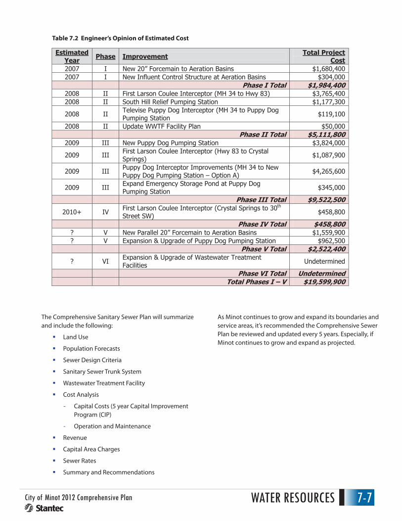
The above improvements are identified in five (5) Phases beginning in 2007. The planning area is shown on Figure ___ and does not extend to the 2-mile boundary. The engineer’s opinion of estimated costs from the preliminary engineering report and noted below. Portions of these improvements have been constructed.
Table 7.1 Proposed Trunk Sewer and Lift Station Cost Estimates
WATER RESOURCES7-6 City of Minot 2012 Comprehensive Plan
PRELIMINARY ENGINEERING REPORT PUPPY DOG SEWER SYSTEM, JANUARY 2007The Puppy Dog Sewer System includes the following:
� Puppy Dog Sanitary Pumping Station and Forcemain
� Puppy Dog Sanitary Sewer Interceptor
� Puppy Dog Sanitary Sewer Collection System
The interceptor/pumping station was constructed in the 1970’s. The study done in January 2007 identified the existing and planning area as follows.
Projected Area PopulationExisting Service Area 1,741 acres 5,200 Planning Service Area 6,380acres 36,207 *
* Assumes year 2040 based on 2.5 households/acre, density 2.27 persons /household
Estimated wastewater flow is the same as North Minot (950 gallons/acre/day). The preliminary engineering states the existing Puppy Dog Interceptor is currently at capacity and surcharges at times. Therefore if nothing is done to improve the facilities development would have to come to a halt. The preliminary engineering identified the following alternatives:
� Puppy Dog Forcemain improvements were identified from the pumping station to the wastewater treatment facility.
� Puppy Dog Pump Station needs to be sized for 20-year planning period.
� Puppy Dog Interceptor is at capacity. Therefore improvements were identified to direct flows from the existing Puppy Dog Interceptor to the new First Larson Coulee Interceptor ranging in size from 15” to 30”.
� The proposed First Larson Coulee Interceptor extends west of 16th Street to serve southwest Minot.
The following improvements are identified in five (5) Phases beginning in 2007. The planning area is shown on Figure ___ and does not extend to the 2-mile boundary. The engineer’s opinion of estimated costs from the preliminary engineering report and noted below. Portions of these improvements have been constructed. Engineer’s Opinion of Estimated Cost
SUMMARY / RECOMMENDATIONSThe previous sanitary sewer report and study in 2007 and 2011 provided analysis and recommendations for existing and proposed facilities. The Wastewater Treatment Facility Plan once completed will address wastewater needs for treatment. This Comprehensive Plan is intended to summarize the findings.
Minot shall review the previous studies in 2007 and 2011 once the Wastewater Treatment Facility Plan is completed. It’s recommended the City review the need to prepare a Comprehensive Sewer Plan for all of Minot reflecting on the goals of this Comprehensive Plan once the goals and objectives are accepted.
WATER RESOURCES 7-7City of Minot 2012 Comprehensive Plan
3
Engineer’s Opinion of Estimated Cost Estimated
Year Phase Improvement Total Project Cost
2007 I New 20” Forcemain to Aeration Basins $1,680,4002007 I New Influent Control Structure at Aeration Basins $304,000
Phase I Total $1,984,4002008 II First Larson Coulee Interceptor (MH 34 to Hwy 83) $3,765,4002008 II South Hill Relief Pumping Station $1,177,300
2008 II Televise Puppy Dog Interceptor (MH 34 to Puppy Dog Pumping Station $119,100
2008 II Update WWTF Facility Plan $50,000Phase II Total $5,111,800
2009 III New Puppy Dog Pumping Station $3,824,000
2009 III First Larson Coulee Interceptor (Hwy 83 to Crystal Springs) $1,087,900
2009 III Puppy Dog Interceptor Improvements (MH 34 to New Puppy Dog Pumping Station – Option A) $4,265,600
2009 III Expand Emergency Storage Pond at Puppy Dog Pumping Station $345,000
Phase III Total $9,522,500
2010+ IV First Larson Coulee Interceptor (Crystal Springs to 30th
Street SW) $458,800
Phase IV Total $458,800? V New Parallel 20” Forcemain to Aeration Basins $1,559,900? V Expansion & Upgrade of Puppy Dog Pumping Station $962,500
Phase V Total $2,522,400
? VI Expansion & Upgrade of Wastewater Treatment Facilities Undetermined
Phase VI Total UndeterminedTotal Phases I – V $19,599,900
SUMMARY / RECOMMENDATIONS
The previous sanitary sewer report and study in 2007 and 2011 provided analysis and recommendations for existing and proposed facilities. The Wastewater Treatment Facility Plan once completed will address wastewater needs for treatment. This Comprehensive Plan is intended to summarize the findings.
Minot shall review the previous studies in 2007 and 2011 once the Wastewater Treatment Facility Plan is completed. It’s recommended the City review the need to prepare a Comprehensive Sewer Plan for all of Minot reflecting on the goals of this Comprehensive Plan once the goals and objectives are accepted.
The Comprehensive Sanitary Sewer Plan will summarize and include the following:
Land Use Population Forecasts Sewer Design Criteria Sanitary Sewer Trunk System Wastewater Treatment Facility Cost Analysis
Capital Costs (5 year Capital Improvement Program (CIP) Operation and Maintenance
The Comprehensive Sanitary Sewer Plan will summarize and include the following:
� Land Use
� Population Forecasts
� Sewer Design Criteria
� Sanitary Sewer Trunk System
� Wastewater Treatment Facility
� Cost Analysis
- Capital Costs (5 year Capital Improvement Program (CIP)
- Operation and Maintenance
� Revenue
� Capital Area Charges
� Sewer Rates
� Summary and Recommendations
As Minot continues to grow and expand its boundaries and service areas, it’s recommended the Comprehensive Sewer Plan be reviewed and updated every 5 years. Especially, if Minot continues to grow and expand as projected.
Approximate Puppy Dog Existing Service Area 1,741 Acres
Approximate North Minot Service Area City Project #3490
Approximate Existing Valley Forcemain Service Area
Approximate Puppy Dog Planning Service Area 6,380 Acres
sshort
Typewritten Text
Figure 7.2
WATER RESOURCES 7-11City of Minot 2012 Comprehensive Plan
STORM WATER MANAGEMENT
Storm GuidelinesThe City of Minot has prepared a Storm Water Design Standards Manual (Manual) dated July 2002 to guide and assist entities needing to comply with its Storm Water Management Ordinance. The development of the Storm Water Management Ordinance and the Storm Water Design Standards Manual was a major step in solving existing and future drainage problems in the Minot area. The City’s Storm Water Management Ordinance requires the development of Storm Water Management Plans and the acquisition of Storm Water Management Permits for most types of land disturbing activities within the City and its extraterritorial jurisdiction. The Storm Water Management Ordinance outlines application procedures, plan review procedures, approval standards, as well as permits, enforcement, and penalties.
MS4The Environmental Protection Agency (EPA) has issued stricter storm water discharge requirements through rules enforced in the Clean Water Act. The rules require the North Dakota Department of Health, as the delegated permitting authority, to issue permits for storm water discharges from small Municipal Separate Storm Sewer Systems (MS4s).
The City of Minot due to its population of 10,000 or greater has been designated as a small MS4. The City must comply with this regulation and must develop, implement and enforce a Stormwater Management Program (SWMP). The City is required to reduce the discharge of pollutants to the maximum extent practicable (MEP) to protect water quality, and to satisfy the appropriate water quality requirements of the Clean Water Act. The SWMP will consist of a combination of Best Management Practices (BMPs), including education, maintenance, control techniques, system design and engineering methods, and such other provisions as determined to be appropriate, to meet the minimum requirements of this permit.
The MS4 general permit requires the City of Minot to create a Stormwater Pollution Prevention Program with six important components:
1. Public education and outreach, which includes teaching citizens about better stormwater management
2. Public participation: Include citizens in solving stormwater pollution problems. This includes a required public annual meeting and an annual report.
3. A plan to detect and eliminate illicit discharges to the stormwater system (like chemical dumping and wastewater connections)
4. Construction-site runoff controls
5. Post-construction runoff controls
6. Pollution prevention and municipal “good housekeeping” measures, like covering salt piles and street-sweeping.
Flood ControlThe City of Minot has several dams upstream on the Mouse (a.k.a. Souris) River that provides flood protection for the City. Lake Darling Dams (constructed in 1936) and upgraded in the ‘90s, and the Rafferty-Alameda Dams (developed over the 1988-95 periods) provide flood protection in the Souris River Valley including the City of Minot. The City has also constructed several levee embankments along the Souris River that also provide additional protection for the City.
The summer of 2011 changed how the City of Minot perceives flood protection from the upstream dams. The City received record rate of flow (27,400 cubic feet per second) – more than five times the rate that the existing channels and levees had been designed to handle and close to nine times the rate of any flood documented since
WATER RESOURCES7-12 City of Minot 2012 Comprehensive Plan
construction of upstream dams. The record breaking flow caused damage to the area in excessive of $900 million.
Due to devastation that occurred throughout the Souris River Valley, local governments recognized the need to develop a plan for flood protection. The Souris River Joint Board issued a request to the North Dakota State Water Commission to develop a “Mouse River Enhanced Flood Protection Project”. The primary objective for the Mouse River Enhanced Flood Project is to develop a preliminary alignment, as well as engineering, environmental, and cost considerations for plan implementation. The total potential cost of this project to implement flood protection features in the City of Minot is over $500 Million. The City of Minot will need to move forward to make improvements to the City’s flood protection and determine as to what extent funding can be provided from various government agencies. The Mouse River Enhanced Flood Protection Project will need to be used by the City as a guide to help reduce risk of damages from future river flows.
Selected Urban Watershed AssessmentsMinot’s Storm Water Management Plan (SWMP) dated August 2003 identified storm water facility improvements and storm water management within the City of Minot. The Plan provides a guideline or framework to decide how to best allocate resources for infrastructure improvements, manage storm water runoff associated with urban development; improvements needed within flood prone areas, and achieve environmental regulatory compliance. Selected urban watershed assessments were reviewed in detail and improvements/costs were developed. A City Ad Hoc Storm Water Committee was formed to prioritize projects. Two projects that are currently underway are the 6th St SW Underpass project and the 21st Ave NW project. The table below lists future projects that have been identified for improvements with priority rankings based on need.
2
Flood Control
The City of Minot has several dams upstream on the Mouse (a.k.a. Souris) River that provides flood protection for the City. Lake Darling Dams (constructed in 1936) and upgraded in the ‘90s, and the Rafferty-Alameda Dams (developed over the 1988-95 periods) provide flood protection in the Souris River Valley including the City of Minot. The City has also constructed several levee embankments along the Souris River that also provide additional protection for the City.
The summer of 2011 changed how the City of Minot perceives flood protection from the upstream dams. The City received record rate of flow (27,400 cubic feet per second) – more than five times the rate that the existing channels and levees had been designed to handle and close to nine times the rate of any flood documented since construction of upstream dams. The record breaking flow caused damage to the area in excessive of $900 million.
Due to devastation that occurred throughout the Souris River Valley, local governments recognized the need to develop a plan for flood protection. The Souris River Joint Board issued a request to the North Dakota State Water Commission to develop a “Mouse River Enhanced Flood Protection Project”. The primary objective for the Mouse River Enhanced Flood Project is to develop a preliminary alignment, as well as engineering, environmental, and cost considerations for plan implementation. The total potential cost of this project to implement flood protection features in the City of Minot is over $500 Million. The City of Minot will need to move forward to make improvements to the City’s flood protection and determine as to what extent funding can be provided from various government agencies. The Mouse River Enhanced Flood Protection Project will need to be used by the City as a guide to help reduce risk of damages from future river flows.
Selected Urban Watershed Assessments
Minot’s Storm Water Management Plan (SWMP) dated August 2003 identified storm water facility improvements and storm water management within the City of Minot. The Plan provides a guideline or framework to decide how to best allocate resources for infrastructure improvements, manage storm water runoff associated with urban development; improvements needed within flood prone areas, and achieve environmental regulatory compliance. Selected urban watershed assessments were reviewed in detail and improvements/costs were developed. A City Ad Hoc Storm Water Committee was formed to prioritize projects. Two projects that are currently underway are the 6th St SW Underpass project and the 21st Ave NW project. The table below lists future projects that have been identified for improvements with priority rankings based on need.
Project Name Rank
4th St SW - 33rd Ave to 37th Ave 1 18th St SW- 33rd Ave to 37th Ave 2 10th St SW - S. of 31st Ave 3 16th St SW - 11th Ave to 16th Ave SW 4 11th Ave SW - To 6th St SW 5 Polaris Park 6 Main St - 35th Ave to 37th Ave SE 7 Southwest Knolls - Phase II at 13th St/12th Ave 8 4th Ave NW- At 8th St NW 9
Table 7.3 Future Project Improvements ???
Summary / RecommendationsThe Storm Water Design Manual and Storm Water Management Plan provided the first step to establish storm water rules and regulations. Storm water improvements were identified in specific areas where storm water standards were not met. The next step is to address storm water needs based on future growth projected in this Comprehensive Plan. Natural water resource areas impacted by future growth must be defined. Storm water management and conveyance of storm water through these areas must be established based on goals and policies of the City that not only comply with all regulatory requirements but the goals of the City. The Area Watersheds included in the 2 mile boundary are on shown Figure___. As developments are reviewed requirements to provide and contribute to the overall management of storm water in the 2 mile boundary is required. Existing storm water deficiencies must be implemented to comply with current standards and the goals of the City. An updated Storm Water Management Plan would address the following:
� Land Use
� Water Resource Inventory
� Goals and Policies
� Water Resource Mapping and Management
� System Assessment
� Implementation Plan
� Best Management Practices
� Education
� Operating and Maintenance
� Cost Financing
� Capital Improvement Program (CIP)
� Summary and Recommendations
The updated SWMP would define the City’s strategies to protect/enhance natural water resources areas and manage storm water conveyance. As growth continues the need to update the plan shall be reviewed by City officials to insure the City’s goals and policies are being met in accordance with expectations.