128 1 Introduction The geographical extent of historic and prehistoric regions and territorial units is a question to which archaeologists return time after time (see Sawyer 1976). It has been argued that territories are maintained in order to exercise and ensure power and social control over the inhabitants. Territories are “fundamentally constitutive of the social order whose features they express. One might go so far as to say that a cultural formation or social order is unintelligible without reference (if only tacit) to how it is territorially expressed” (Delany 2005:10). A study of territorial organization can thus often provide important insights into the nature and level of organization of a society. In order to understand a society, or a group within a society, it is often necessary to compare it with its neighbors in order to highlight similarities and differences. The identified differences can then be seen to illustrate some aspect of the chosen society and its social organization. The spatial extent of such regions are, how- ever, difficult to reconstruct if there are no historical sources or maps, since the archaeological material rarely leaves any evidence of boundary markers such as earthworks, stand- ing stones, etc. Often, though, there is a name associated with a territory, which usually has been designated by those who live nearby (Brink 1997:391). For pre-state societies it may also be difficult to assess exactly what constitutes a territory. Regions may be seen as the land rights of an ethnic group, and thus far from permanent in the landscape. Often, even “social boundaries…may have territorial coun- terparts” (Barth 1969:15), and sometimes it is possible to trace the territories back to regions that are delimited by natural features. With an increasing level of social organi- zation, the boundaries would become more permanent and may remain even if they later change function and lose the relation to the landscape features that initially formed them. This can be seen in the example of the origin of parishes in Sweden, where the medieval ecclesiastical system was at times superimposed onto an older system of districts. These districts may have had the same locations for cultic and legal practices, which can be traced through surviving place-names (Brink 1990:354). In this paper a method for reconstructing the conditions for natural regions through topographic landscape analysis will be suggested. 2 The Hundred Organization in Central Sweden The earliest formal administrative land units known in Sweden are the medieval härad (in the southern parts of the country) and hundare (in the Mälardalen area), which from the 14 th century AD, also came to be called härad. These units are known from written sources, primarily the medieval provincial laws that date back at least to the late 13 th to early 14 th century, from which time manuscripts have survived. From these laws it can be understood that each hundare was further divided into skiplag (the unit that supplied one ship), which in turn were divided into even smaller units. The description of the different units in the provincial laws makes it clear that these were linked to the maritime defense, i.e., the ledung organization. The hun- dare also formed the judicial districts within which the inhabitants gathered at their thing sites to settle legal affairs. The thing sites may also have been relevant for the reli- gious cult. At the time when the extant laws were written down, this organization was about to become obsolete and replaced by a system of taxation. It is difficult to know how old the ledung organization is. Through the written sources the ledung organization cannot be traced back further than the time when the laws were written down. It is, however, often suggested that the origin of the laws date back at least to the Viking period. This is indicated by the runic inscrip- tion dated to c. AD 1000 in which a man claims to have con- trolled “a whole hundare” (Carlsson and Rosén 1978). The origin of the hundare organization is often seen to have been influenced by the centenaries and centena of the Roman army, units of approximately 100 warriors. Linguists, on the other hand, have suggested that the hundare organization can be traced back to the time before the Roman-Frankish influence, as seen in the Germanic terms hund and hundare. Watersheds as a Method for Reconstructing Regions and Territories in GIS Daniel Löwenborg Department of Archaeology and Ancient History Uppsala University Uppsala, Sweden [email protected]Abstract In this paper a method for reconstructing territories through the calculation of watersheds from the topography is put forward. Watershed could, in some cases, work as a natural uniting factor for a region, e.g., connecting a region through a system of rivers used for commu- nications, as a unit for land management, or as an otherwise uniting element. This method provides an opportunity to analyze territories and regions that, although often difficult to distinguish in the archaeological material, are crucially important for the understanding of past societies. This article illustrates the use of watershed analyses in relation to territorial units through examples from the province of Västmanland in central Sweden, and Hawaii, but the method could be applied to any geographical area.
Transcript
128
1 Introduction
The geographical extent of historic and prehistoric regions and territorial units is a question to which archaeologists return time after time (see Sawyer 1976). It has been argued that territories are maintained in order to exercise and ensure power and social control over the inhabitants. Territories are “fundamentally constitutive of the social order whose features they express. One might go so far as to say that a cultural formation or social order is unintelligible without reference (if only tacit) to how it is territorially expressed” (Delany 2005:10). A study of territorial organization can thus often provide important insights into the nature and level of organization of a society. In order to understand a society, or a group within a society, it is often necessary to compare it with its neighbors in order to highlight similarities and differences. The identified differences can then be seen to illustrate some aspect of the chosen society and its social organization. The spatial extent of such regions are, how-ever, difficult to reconstruct if there are no historical sources or maps, since the archaeological material rarely leaves any evidence of boundary markers such as earthworks, stand-ing stones, etc. Often, though, there is a name associated with a territory, which usually has been designated by those who live nearby (Brink 1997:391). For pre-state societies it may also be difficult to assess exactly what constitutes a territory. Regions may be seen as the land rights of an ethnic group, and thus far from permanent in the landscape. Often, even “social boundaries…may have territorial coun-terparts” (Barth 1969:15), and sometimes it is possible to trace the territories back to regions that are delimited by natural features. With an increasing level of social organi-zation, the boundaries would become more permanent and may remain even if they later change function and lose the relation to the landscape features that initially formed them. This can be seen in the example of the origin of parishes in Sweden, where the medieval ecclesiastical system was at times superimposed onto an older system of districts. These districts may have had the same locations for cultic and legal practices, which can be traced through surviving place-names (Brink 1990:354). In this paper a method for
reconstructing the conditions for natural regions through topographic landscape analysis will be suggested.
2 The Hundred Organization in Central Sweden
The earliest formal administrative land units known in Sweden are the medieval härad (in the southern parts of the country) and hundare (in the Mälardalen area), which from the 14th century AD, also came to be called härad. These units are known from written sources, primarily the medieval provincial laws that date back at least to the late 13th to early 14th century, from which time manuscripts have survived. From these laws it can be understood that each hundare was further divided into skiplag (the unit that supplied one ship), which in turn were divided into even smaller units. The description of the different units in the provincial laws makes it clear that these were linked to the maritime defense, i.e., the ledung organization. The hun-dare also formed the judicial districts within which the inhabitants gathered at their thing sites to settle legal affairs. The thing sites may also have been relevant for the reli-gious cult. At the time when the extant laws were written down, this organization was about to become obsolete and replaced by a system of taxation. It is difficult to know how old the ledung organization is. Through the written sources the ledung organization cannot be traced back further than the time when the laws were written down. It is, however, often suggested that the origin of the laws date back at least to the Viking period. This is indicated by the runic inscrip-tion dated to c. AD 1000 in which a man claims to have con-trolled “a whole hundare” (Carlsson and Rosén 1978). The origin of the hundare organization is often seen to have been influenced by the centenaries and centena of the Roman army, units of approximately 100 warriors. Linguists, on the other hand, have suggested that the hundare organization can be traced back to the time before the Roman-Frankish influence, as seen in the Germanic terms hund and hundare.
Watersheds as a Method for Reconstructing Regions and Territories in GIS
Daniel Löwenborg
Department of Archaeology and Ancient HistoryUppsala UniversityUppsala, Sweden
In this paper a method for reconstructing territories through the calculation of watersheds from the topography is put forward. Watershed could, in some cases, work as a natural uniting factor for a region, e.g., connecting a region through a system of rivers used for commu-nications, as a unit for land management, or as an otherwise uniting element. This method provides an opportunity to analyze territories and regions that, although often difficult to distinguish in the archaeological material, are crucially important for the understanding of past societies. This article illustrates the use of watershed analyses in relation to territorial units through examples from the province of Västmanland in central Sweden, and Hawaii, but the method could be applied to any geographical area.
129
Thorsten Andersson (1999:11-12) argued that the Old High German noun hunno may originally have meant “‘leader of a hundred men’ and which, judging from its archaic word-formation type, stretches far back into Proto-Germanic or even earlier times.”
Archaeologists studying the origins of the hundare have often started with the idea of a connection between the number 100 and a unit. The number of burial grounds or “settlement units” in different areas has been compared to the boundaries of the medieval administrative units. Through different mathematical models and comparisons of the varying sizes of the administrative units in relation to the number of settlements units in the area, it should thus be possible to reconstruct the development of the hundare (Hyenstrand 1974). The general idea with this model is that a correspondence can be found between the size of the hundare and the number of settlement units, so that each hundare would contain one hundred units. However, when it has been impossible to identify a region with 100 units, there has instead been suggested other types of hundare to match larger or smaller areas. This idea has been picked up by other scholars who sometimes substituted the term “set-tlement units” with “warriors” or other terms (Ambrosiani 1982; Larsson 1993:107). This theory has, however, several severe problems. Perhaps the most important problem is the mathematical reconstruction of the settlements of a whole region when only fragmented archaeological data remain. Another problem is the degree of administrative control that would be necessary in order to maintain such an intricate system in a pre-state society, where one can assume that
there was limited access to records of the population and means of cartography.
3 Watersheds and Regions Based on Maritime Communications
In an article on the medieval administrative units in the Mälaren valley from 1949, the historian Adolf Schück com-ments that the rivers that today form borders between differ-ent provinces were unlikely to have formed natural borders but were instead political or artificial. Schück argued that the river networks functioned as uniting element and thus formed the bases of regions, as can be seen in several exam-ples from the early history of Sweden (Schück 1949:18). In the province of Västmanland, it is apparent that the rivers and eskers that run through the region from north to south have, throughout history, constituted important elements in the landscape. The northern area of Västmanland is rich in natural resources, especially furs and iron ore, but sparsely populated compared to the fertile soils around the lake Mälaren in the south. The rivers and eskers formed a com-munication network that connected the northern part of the region to the southern area, which in turn is linked to one of the most dynamic areas of Iron Age Sweden, i.e., the areas around the eastern part of lake Mälaren. Virtually all of the most important sites from the Iron Age to the early medieval period are located in close relation to this communication network. Recognition of this condition stimulated the idea of creating watersheds, or “water catchment areas” from the
digital elevation model (DEM) of the area. When the water-sheds were compared to the hundare boundaries, striking similarities were found in some boundaries (Fig. 1 and 2).
The best match between watershed and hundare bound-ary is found in the large hundare of Norrbo where the out-lines are fairly similar, with the exception of a few parishes to the east and west that might have been added later. The western boundary of Tjurbo hundare has probably been adjusted to follow the major watercourse Sagån in later times, as it may have been seen as a suitable border between the provinces of Västmanland and Uppland. It is interesting to note that the watershed does not stretch very far to the east of the river, which makes the river an appropriate politi-cal border that follows the original region relatively well. The shape of Gorunda hundare is difficult to reconstruct and has changed considerably over time. It seems to be related to the major natural feature of the Badelunda esker that con-stitutes the border with Norrbo. In later times Gorunda fol-lowed the esker further to the north. Another major esker seems to have been marking the boarder between Tuhundra and Snävringe hundare.
The apparent anomaly in the small hundare of Seunda is also interesting to study. In this case we do not see the elongated form of the other watersheds, but instead there are several minor streams that each have a small basin. Taken together, these small areas constitute the spatial base of the hundare. In the case of Tuhundra, it is possible that this area originally consisted of two separate hundare that were later merged. This is suggested by the hundare name itself, as it possibly denotes “two-hundred.” This interpretation would also support the idea of watersheds being the origin of the territory, where the watersheds of Tuhundra have not been large enough for them to form independent hundare in the long run. From the map of watersheds it is easy to imagine an eastward and a westward original region in the area of the later Tuhundra.
If we zoom out to a regional scale, the extent of the watersheds that flow through the district of Västmanland closely match the extent of Västmanland as a whole, both stretching northwards to the watershed where the land starts to drain to the north into the basin of the river Dalälven, which in turn constitutes the district of Dalarna. The same relation between district and watershed can be observed in several other areas in Sweden, such as the ancient region of Tiundaland in Uppland that correlates to the basin of the river Fyrisån, and so forth. Indeed, the boarder between Sweden and Norway closely follows the watershed in the mountainous region between the two countries.
The correlations between watersheds and hundare boundaries highlight the importance of the rivers as a unit-ing factor and suggests that the hundare organization was originally built up around these “natural regions.” People who where living within the area of one of these watersheds would have been using the same water routes for commu-nication and, thus, probably the same assembly sites. These regions would easily be experienced and manifested as dis-crete geographical units in a society that to a large extent depended on rivers for long distance communications, as was the case for Iron Age Västmanland. Various sources make it clear that boats played an important part of the
society of the Mälardalen area in the later Iron Age, which can also be seen in symbolic and ideological elements such as the wealthy boat graves of the area (Schönbäck 1994). It has even been claimed that there was a “maritime society” at the time, due to the emphasis on boats and maritime com-munications (Larsson 2007).
To some extent, it might also be possible to visually dis-tinguish the edges of the “valley” around these water catch-ments. Since the landscape in Västmanland is rather flat, with only slight differences in elevation, the visual experi-ence of valleys is unlikely to have been the prime reason for these divisions, but might instead have played a com-plementary role. This applies especially to the edges of the regions, where the water courses were less pronounced and the visual aspect might have been more important. These water-based networks could thus form the foundation of a more permanent territorial organization. The possibility of using a set of territories with such clearly manifested spatial extents would be of great value to anyone who would like to increase the control over people of a large area.
It is not possible to determine how old the use of these natural regions could be through the analysis of watersheds alone. It is, however, possible that this kind of organiza-tion should be seen in connection to the ledung organiza-tion. Since the ledung was explicitly organized around ships, with a number of skiplag that were responsible for the upkeep of a war ships and maritime connections, it might have seemed natural to divide them according to these “watershed regions.” However, as pointed out above, both the ledung and the hundare organizations are first known from the middle ages, about the 14th century AD. It seems likely that, in medieval times, land routes were constructed to a higher degree than before, such as the Eriksgata, known from medieval sources. A strictly river-based communica-tion network would thus be of less importance and less likely to form the base of territorial organization. An admin-istrative organization based on maritime communications is therefore likely to be of a more ancient origin.
Very similar results have also been observed by Eric Klingelhöfer for the Hampshire area in the United Kingdom. Klingelhöfer distinguishes territorial divisions that were “physically defined by valleys and catchment areas” (Klingelhöfer 1992:84). These valley units are described as archaic hundreds, and would represent “a half-way stage between a unit of Germanic tribal society and the territorial jurisdictions of the hundred” (Klingelhöfer 1992:84). The hundare in Sweden have much in common with the hundred organization of medieval England, but scholars have often refrained from making very close comparisons between the areas since there is, especially in Sweden, little substantive knowledge of the origin of the hundare. For both areas, however, a Danish influence for the origin of the adminis-trative organization is often suggested.
4 GIS and Hydrological Analysis
Watershed analysis is a well established and common prac-tice within many natural sciences, such as geology, biol-ogy, forestry, and ecology. It is also increasingly used as
131
an analytical tool for land and water management (Reid at al. 1994). In archaeology, the use of watershed analysis has not received much attention so far, with the exception of Klingelhöfers study mentioned above. To my knowledge, there has been no previous study performed utilizing hydro-logical modeling of the terrain in GIS in order to estimate the boundaries of regions. However, the notion is touched upon in some studies where watersheds have been used as natural limitations (Lindholm 2006; Strömquist et al. 1999) and hydrological calculations have been used to study set-tlement patterns in relation to flooding (Gillings 1995).
For the purpose of this study, the standard tools for hydrological modeling that come with the Spatial Analysis Extension to ArcGIS 9 were used. The process of calcu-lating a watershed is fairly straight forward, and normally involves the following steps: 1) amending the DEM by fill-ing any sinks that might be present (see below); 2) creating a “flow direction” raster from the DEM; 3) creating a “flow accumulation” raster from the “flow direction” raster; 4) cre-ating the pour points from which the watersheds should be calculated; 5) “snapping” the pour points to the appropriate location in relation to the flow accumulation raster (within a defined distance); and 6) calculating the watersheds to the pour points from the flow direction raster. It can also be a good idea to change the resulting raster watersheds to vector shapefiles for improved handling.
The main technical concern when carrying out a water-shed analysis is the quality of the DEM. The Swedish cadas-tral and maps agency Lantmäteriet provides a high resolution elevation model, with 50-m pixels, at no charge to Swedish students and academics. Although this DEM is considered to be of fairly high quality, and used for creating the official maps of Sweden as well as for research, it was not of high enough quality for this study. The watersheds calculated from this DEM did not cover the whole basin, since the DEM was not hydrologically correct. Instead, a DEM was created from a set of 5 m equidistant contour lines. With this new DEM it was possible to create good watersheds. Preliminary testing of Shuttle Radar Topography Mission data acquired from the Global Land Cover Facility (GLCF) has also provided similarly, but not identical, good results.
It is possible to create watersheds manually from the con-tours of a map, and this has also been seen to be more accu-rate than computerized calculations. Comparisons between manual and computerized methods have shown that a DEM with a resolution of at least 30 m gives accurate watersheds, and it is also possible to manually correct the DEM in accor-dance to streams if necessary (Shamsi 2005:95-101). Before any hydrological modeling can be performed on a DEM, they usually need to be corrected for sinks. Sinks rarely occur in reality but are the results of data noise or errors (Shamsi 2005:87). The resulting maps showing the water-sheds would give complete coverage, since every point of a landscape drains somewhere (Grip and Rodhe 1985:11). The watersheds would also be fairly stable over time and not change much for areas where there is no pronounced erosion or geomorphologic processes.
5 Watersheds as Administrative Units on Hawaii
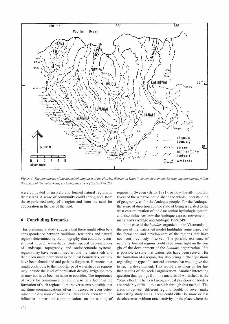
A possible example of where watersheds were important for the spatial formation of regions in historical times is provided by the ahupua´a land units in some parts of the Hawaiian Islands. The chiefdoms of the Hawaiian Islands were organized in a stratified hierarchy of economic classes, and they had an administration resembling that of a pre-state society. The largest islands were divided into regions called moku, or chiefdoms. For smaller islands one moku could comprise the whole island. Each moku was divided into districts called ´okana that in turn were constituted of small local community divisions, the ahupua´a (Earle 1978:15-19). The ahupua´a was the primary unit for land tenure and management, and they were the center for the well being of the population and religious practices. The traditional division of the islands into ahupua´a is still rel-evant to the inhabitants of the islands, since these territories represent such marked natural regions and form the bases of the communities. The term ahupua´a comes from an altar (ahu) with a pig (pua´a) on it, which represented the district (Wilcox et al. 1998). Especially in the windward regions of Hawaii where the landscape is dominated by rivers and val-leys, the boundaries of an ahupua´a are often determined by the topography, so that each ahupua´a represents one valley or water catchment basin. However, at times the boundar-ies deviated from the ridges at the edge of the watersheds in order divide sections of natural resources between dif-ferent ahupua´a (Earle 1978:25). Generally, however, the ahupua´a in the windward parts of the Hawaiian Islands followed the outline of the watershed fairly closely, as can be seen in Figure 3. An ahupua´a could be further divided into segments, called ´ili. These might originally have rep-resented the land of a single family, and also stretched as a narrow strip from shore to the mountain top, although sometimes they were split into one costal and one inland part (Handy 1950:176-177).
Each level in the hierarchy of the region was represented by a chief who administered his region and reported to the chief of the moku (the ali´i moku). The ahupua´a functioned as a mainly self-sustaining unit and was generally under the jurisdiction of an appointed konohiki who controlled the day-to-day management of the ahupua´a (Handy 1950). One theory that has been put forward states that the need for centralized management of irrigation systems could be a reason why chiefdoms evolved out of more decentralized socio-political organizations. However, since the irriga-tion systems on Hawaii were generally small and simple, these would probably not require centralized management by themselves, and the formation of the chiefdoms seems instead to be the result of several different factors (Earle 1978). The special conditions of the Hawaiian Islands have contributed to the development of the ahupua´a. Traditional Hawaiian society has been described as rural, with no vil-lage units regulated by established institutions. The main bonds were instead to the family, which was connected to a certain location (Handy 1950). The formation of regions around the valleys in parts of Hawaii seems to be a logi-cal result of the distinct topography, with fertile valleys that
132
were cultivated intensively and formed natural regions in themselves. A sense of community could spring both from the experienced unity of a region and from the need for cooperation in the use of the land.
6 Concluding Remarks
This preliminary study suggests that there might often be a correspondence between traditional territories and natural regions determined by the topography that could be recon-structed through watersheds. Under special circumstances of landscape, topography, and socioeconomic systems, regions may have been formed around the watersheds and then been made permanent as political boundaries, or may have been abandoned and perhaps forgotten. Elements that might contribute to the importance of watersheds as regions may include the level of population density. Irrigation may or may not have been an issue to consider. The importance of rivers for communication could also be a factor in the formation of such regions. It moreover seems plausible that maritime communications often influenced or even deter-mined the divisions of societies. This can be seen from the influence of maritime communications on the naming of
regions in Sweden (Brink 1981), or how the all-important rivers of the Amazon could shape the whole understanding of geography, as for the Andoque people. For the Andoque, the sense of direction and the state of being is related to the west-east orientation of the Amazonian hydrologic system, and also influences how the Andoque express movement in many ways (Arango and Andoque 1999:249).
In the case of the hundare organization in Västmanland, the use of the watershed model highlights some aspects of the formation and development of the regions that have not been previously observed. The possible existence of naturally formed regions could shed some light on the ori-gin of the development of the hundare organization. If it is possible to state that watersheds have been relevant for the formation of a region, this also brings further questions regarding the type of historical contexts that would give rise to such a development. This would also open up for fur-ther studies of the social organization. Another interesting question that springs from the analysis of watersheds is the “edge effect.” The exact geographical positions of borders are probably difficult to establish through this method. The areas in-between different regions would, however, make interesting study areas. These could either be more or less desolate areas without much activity, or the place where the
Figure 3. The boundaries of the historical ahupua´a of the Halelea district on Kaua´i. As can be seen on the map, the boundaries follow the extent of the watersheds, enclosing the rivers (Earle 1978:26).
133
inhabitants of different regions met and interacted. In cases where the regions represent different natural environments, such as on the British isles where some watersheds stretch east and others west, these areas of contact between dif-ferent watersheds could represent interesting areas for the exchange of goods and cultural influence.
When using watersheds in archaeological investigation, it is usually not the hydrological model of a watershed per se that would be of interest, but rather the social adaptation to the topography that can be studied in comparison with the watersheds. The constituting force of regions is the people who inhibit the area and their social relations. Human soci-ety is not directly visible in this study, but will have to be included in some other way. One way to do this could be to use a “point field” concept in order to study regions as socially constituted spaces, or some kind of “cost-benefit weighted social distances” (Herdrich and Clark nd; Whitley in press). For my study this will be done by including the large number of prehistoric grave fields in the region as part of a settlement historical study to complement the study of the territorial organization. The advantage of studying ter-ritories in relation to watersheds is that there is no need for any social premises in order to calculate the watersheds. Instead, the starting point for the study is the actual physi-cal landscape and topography of the area, in combination with hydrological models. If the population within a water-shed experiences a common interest or bond, this may result in a region forming around the naturally formed water catchments.
Watersheds do not represent an out-of-the-box solution that can identify relevant locations for any region or time. This type of analysis can, however, be used as a powerful tool for studying possible relations between human societies and the physical landscape. Even if explicitly hydrological aspects are not the focus of the study, watershed modeling would often provide a better method for studying spatial relations than the frequently used method of buffering. A watershed could also be seen to delimit a natural region, similar to a valley, which often could be a manifest experi-ence of a landscape. This is well illustrated by the example of the Hawaiian Islands:
Scientists, community organizations, land-use planners, and governments have been discover-ing in recent years what Hawaiians discovered centuries ago: that land systems defined by natural cycles and patterns of water movement provide the basic functional units for understanding and managing human ecosystems. Further, only within the past several years have western scientists and government agencies realized that effective programs of environmental and natural resource management require organization and action at the watershed level—something some Polynesian and other Eastern cultures had basically been practic-ing for centuries. For example, little more than a decade ago, researchers based at the East-West Center in Honolulu began studying interdisci-plinary approaches to resource management and economic development using a watershed model. Ironically, in thinking about how to solve the prob-lem of integrating economics and ecology, they
“discovered” what Hawaiians had determined centuries ago: watersheds are the natural unit of focus for understanding and managing both bio-physical and socio-cultural processes upon which the sustainability of human communities depends. (Wilcox et al. 1998:Section 2.1)
This development can also be seen within the European Union, where a Water Framework Directive (2000/60/EC) has been established that uses watersheds, or river basin districts, as the base for administrative organization for the protection and management of water resources.
Where circumstances are appropriate, the fast and sim-ple method of creating watersheds could thus be an interest-ing and intuitive way of establishing archaeological study areas that are not constrained by the political geographies of later history. And where historical regions are known, the use of watersheds might cast some light on how these ter-ritories were formed.
Acknowledgements
I would like to thank Tom Riley and Alex Sanmark for their friendly advice and support.
References Cited
Ambrosiani, Björn. 1982. Hundare, skeppslag och forn-lämningar. Bebyggelsehistorisk tidskrift 4:67-82.
Andersson, Thorsten. 1999. Hundare och det germanska hundratalet. Namn och bygd 87:5-12.
Arango, Mónica E. and Andoque, Fisi. 1999. Managing the world: territorial negotiations among the Andoque peo-ple of the Colombian Amazon. In, The Archaeology and Anthropology of Landscape. Shaping your landscape. P. J. Ucko, R. Layton, eds., pp 240-253. London: One World Archaeology 30.
Barth, Fredrik. 1969. Introduction. In, Ethnic Groups and Boundaries. The Social Oranization of Culture Difference. F. Barth, ed., pp 9-38. Oslo: Universitetsforlaget.
Brink, Stefan. 1981. Namnet Hälsningland. Namn och bygd 69:115-151.
Brink, Stefan. 1990. Sockenbildning och sockennamn. Studier i äldre territoriell indelning i Norden. Uppsala: Acta Academiae Regiae Gustavi Adolphi 57.
Brink, Stefan. 1997. Political and social structures in early Scandinavia II. Tor 29:389-437.
Carlsson, Sten and Rosén, Jerker. 1978. Svensk historia I. Tiden före 1718. Stockholm: Esselte studium.
Delany, David. 2005. Territory, A Short Introduction. Pondicherry: Blackwell.
134
Earle, Timothy. 1978. The Economic and Social Organization of A Complex Chiefdom: The Halelea District, Kauai, Hawaii. Anthropological Papers 63. Ann Arbor: University of Michigan.
Gillings, Mark. 1995. Flood dynamics and settlement in the Tisza valley of north-east Hungary: GIS and the Upper Tisza Project. In, Archaeology and Geographical Information Systems. G. Lock and Z. Stancic, eds., pp. 67-84. London: Taylor & Francis.
GLCF (Global Land Cover Facility). Earth Science Data Interface (ESDI) at the Global Land Cover Facility. University of Maryland. http://glcfapp.umiacs.umd.edu:8080/esdi/index.jsp (Accessed 4 August 2006).
Grip, Harald and Rodhe, Allan. 1985. Vattnets väg från regn till back. Uppsala: Hallgren & Fallgren.
Handy, Craighill E. S. 1950. The Hawaiian family system. The Journal of the Polynesian Society 59:170-190.
Herdrich, David J. and Clark, Jeffrey T. nd. Beyond Dualisms: The Point Field Concept in Samoa. Unpublished manuscript, in possession of authors.
Hyenstrand, Åke. 1974. Centralbygd - randbygd. Strukturella, ekonomiska och administrativa huvudlinjer i mellansvensk yngre järnålder. Stockholm: Acta Universitatis Stockholmiensis. Studies in North-European Archaeology 5.
Klingelhöfer, Eric. 1992. Manor, Vill, and Hundred. The Development of Rural Institutions in Early Medieval Hampshire. Wetteren: Universa.
Larsson, Gunilla. 2007. Ship and Society: Maritime Ideology in the Late Iron Age Sweden. Uppsala: Aun 37.
Larsson, Mats G. 1993. Kung Eriks nyordning? Spår efter samhällsorganisation i vikingatidens Uppland. Upplands fornminnesförenings årsbok 1993:105-134.
Lindholm, K-J. 2006. Wells of Experience. A Pastoral Land Use History of Omaheke, Namibia. Uppsala: Studies in Global Archaeology 9.
Reid, Leslie M., Ziemer, Robert R., Furniss, Michael J. 1994. Watershed Analysis in the Federal Arena. Watershed Management Council. Published 1994. http://watershed.org/news/fall_94/federal.html (Accessed 2 August 2006).
Sawyer, Peter H. (ed.) 1976. Medieval Settlement. Continuity and Change. Norwich: Edward Arnold.
Schück, Adolf. 1949. Svithjod och folklanden. Ett diskus-Ett diskus-sionsinlägg. In, Historiska studier tillägnade Nils Ahnlund 23/8/1949. Å. Stille, ed., pp. 8-50. Stockholm: Norstedts.
Schönbäck, Bengt. 1994. Båtgravskicket. In, Tuna i Badelunda. Guld kvinnor båtar. 1. E. Nylén and B. Schönbäck, eds., pp. 122-131. Västerås: Västerås kultur-nämnds skriftserie 27.
Shamsi, U. M. 2005. GIS Applications for Water, Wastwater and Stormwater System. Boca Raton: Taylor & Francis.
Strömquist, Lennart, Yanda, Pius, Msemwa, Paul, Lindberg, Clas, Simonsson-Forsberg, Louise. 1999. Utilizing Landscape Information to Analyze and Predict Environmental Change: The Extended Baseline Perspective. Two Tanzanian Examples. Ambio Vol. 28 No. 5:436-443.
Westin, Gunnar T. 1953-1971. Det medeltida Sverige. In, Atlas över Sverige. M. Lundqvist ed., pp. 133-134. Stockholm: Generalstabens litografiska anstalts förlag.
Whitley, Thomas G. In Press. On the Frontier: Looking at Boundaries, Territoriality, and Social Distance with GIS. Proceedings, CAA 2004. Annual Conference of Computer Applications in Archaeology, Prato, April 13-18, 2004.
Wilcox, Bruce A., Guinther, Eric B., Duin, Kristin N., Maybaum, Hilary. 1998. The Watershed as a Basic Resource Management Unit. Môkapu: Manual for Watershed Health and Water Quality. Environmental Compliance and Protection Department, Marine Corps Base Hawaii. https://www.denix.osd.mil/denix/Public/Library/Watershed/wqm-sec1.html (Accessed August 9 2006).