132
DISASTER MANAGEMENT PLAN- 2014 OFFICE OF THE DISTRICT MAGISTRATE, PASCHIM MEDINIPUR 1

DISASTER MANAGEMENT PLAN- 2014
OFFICE OF THE DISTRICT MAGISTRATE, PASCHIM MEDINIPUR
1
FOREWORD
2
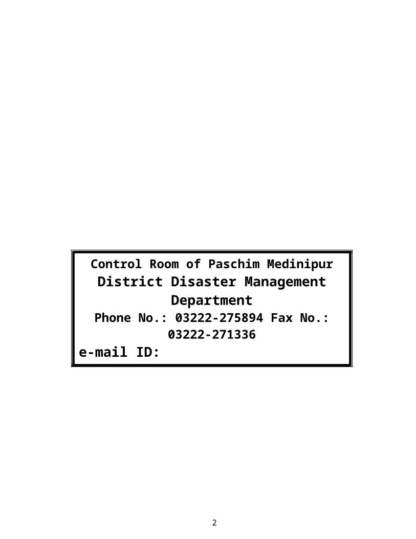
Control Room of Paschim Medinipur District Disaster Management Department
Phone No.: 03222-275894 Fax No.: 03222-271336e-mail ID: [email protected]

Disaster management is a process or strategy that is implemented when any type of catastrophic event takes place. The process may be initiated when anything threatens to disrupt normal operations or puts the lives of human beings at risk. Identifying potential disasters makes it possible to create contingency plans, assemble supplies, and create procedures that can be initiated when and if a given disaster does come to pass. A truly comprehensive disaster management plan will encompass a wide range of possibilities that can easily be adopted in the event one disaster sets off a chain reaction of other types of disasters in its wake.
Paschim Medinipur district in the past have experienced disasters like flood, drought, cyclone etc. In the year 2007 this district has faced four successive floods and an extensive area of the district was hit by AILA in the year 2009. It is a fact that Natural Disasters cannot be prevented. We can minimize the suffering of the affected people by providing assistance to affected people in case of emergency. Preparation of Disaster Management Plan 2014 is viewed as a part of preparedness with a view to take appropriate action to save human lives and properties in the face of disaster.
The Disaster Management Plan 2014 is an effort of Disaster Management Section of Paschim Medinipur Collectorate and other line departments. These departments actively engage themselves during the period of disasters like flood, cyclone etc. The action plan and contingency plan of these departments have been incorporated in this Plan.
I hope that this plan will be immensely helpful to the Government officers of Paschim Medinipur and will be an important source of information and document in the event of disasters. I further hope that this plan will also prove helpful in serving the purpose of saving affected people and mitigating their sufferings with the efforts and dedication of all the persons associated with Disaster Management.
Dated: (Md. Gulam Ali Ansari, I.A.S.)
District Magistrate Paschim Medinipur
TABLE OF CONTENTS List of AcronymsList of MapsList of Annexures
3
List of TableCHAPTERS 1. Introduction
1.1 Background1.2 Changing Context of Disaster Management and Enactment of DM Act in India and West Bengal1.3 Methodology of Developing District Disaster Management Plan1.4 Objectives and strategies of the plan
1.5 Nodal ministries related to various categories of disasters1.6 Importance of Disaster Management Plan1.7 The main features of Disaster Management Plan
2. District Profile2.1 Location and boundaries2.2 Multifarious Regional Diversity2.3 Topography2.4 Natural Division2.5 River System2.6 History of Disaster in the district2.7 Drought and Cyclone susceptibility 2.8 Account of pretitection and temparature2.9 Some indicates of Paschim Medinipur vis-à-vis the State of West Bengal2.10 Natural resources.2.11 Demographic Profile2.12 Land use pattern and cropping intensity.
3. Hazard, Vulnerability & Risk Assessment3.1 What is Disaster.3.2 Clasification of Disaster.3.3 What is Cyclonic Storm.3.3.1 Status of cyclone warning centre in Paschim Medinipur.3.3.2 Four Stage cyclone warning system3.3.3 Standard Precautionary measures
a) Before Cyclonic Seasonb) When Cyclone Threatens.c) Post cyclonic measures
3.3.4 Identification of cyclone prone areas of the district.
3.4 Drought 3.4.1 Action Plan for drought3.4.2 Objective3.4.3 Sugestive areas of intervention3.4.4 Action point for Block / GP
3.5 Risk Analysis
4

4. Disaster Management Functional Structure in the District4.1 District Disaster Management Authority 4.1.1 Role of DDMA4.2 District Disaster Management Committee
5. Rehabilitation and Reconstruction Plan5.1 Post Disaster reconstruction and rehabilitation5.2 Administrative relief5.3 Reconstruction of houses damage/destroyed5.4 Military Assistance5.5 Medical care5.6 Epidemic5.7 Corpse Disposal5.8 Salvage5.9 Outside assistance5.10 Special relief5.11 Information5.12 Social Rehabilitation
6. Some valuable information & Action Plan/ Standard Operating Procedure6.1 Flood Prone Areas6.2 Reserve Stock of Relief Materials6.3 Present position and further requirement of Relief Contingency, Cash GR and Starvation GR6.4 Camping Sites6.5 List of places sutitable for Helicopter landing6.6 List of places for dropping of Relief Materials.6.7 Standard Operating procedure of Irrigation and Waterways Department.6.8 Standard Operating procedure of kaliaghai-kapaleswari-baghai project division under western
circle – ii, i&w dte, temathani, sabong, Paschim Medinipur6.9 Standard Operating procedure of Food & Supply Department.6.10 Standard Operating procedure of Superintendent of Police, Paschim Medinipur.6.11 Standard Operating procedure of FPI & Horticulture.6.12 Standard Operating procedure of Sericulture.6.13 Standard Operating procedure of Health.6.14 Standard Operating procedure of PHE (Civil Division)6.15 Standard Operating procedure of Animal Resource Development Department6.16 Standard Operating procedure of Agriculture 6.17 Standard Operating procedure of Agri-Mechanical Department6.18 Standard Operating procedure of Agri-Irrigation.6.19 Standard Operating procedure of PWD (Roads) and PWD (NH)6.20 Standard Operating procedure of Civil Defence Department.
5

LIST OF ACRONYMS
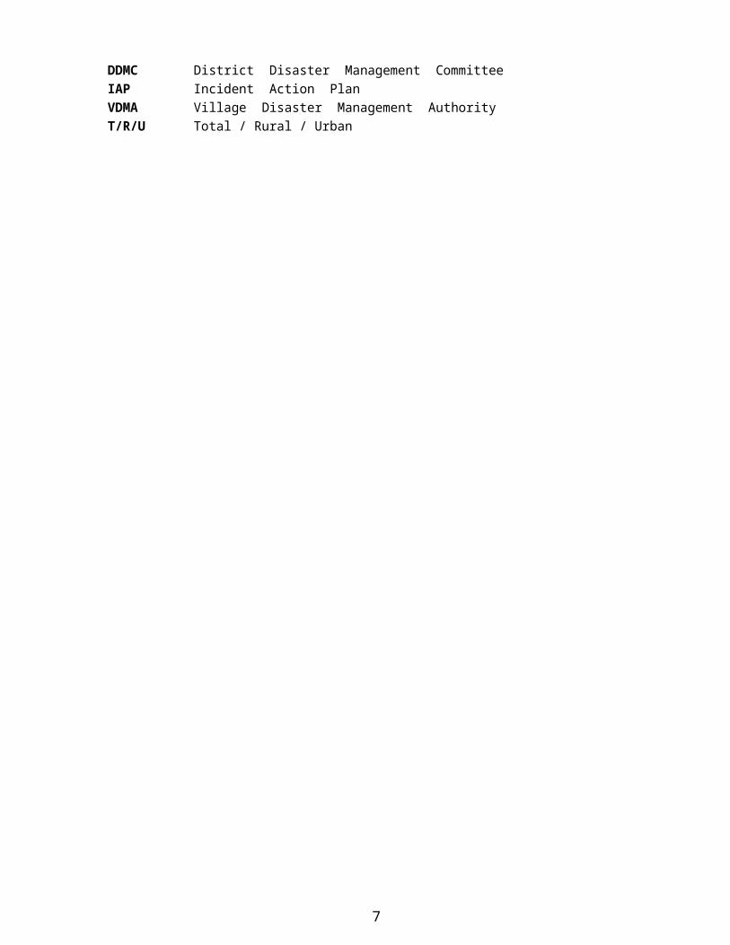
CBO’s Community Based OrganisationDCG District Crisis GroupDDMA District Disaster Management AuthorityDDMC District Disaster Management CommitteeIAP Incident Action PlanVDMA Village Disaster Management AuthorityT/R/U Total / Rural / Urban
6
LIST OF MAPS
Map-1: District Map of Paschim Medinipur showing Blocks
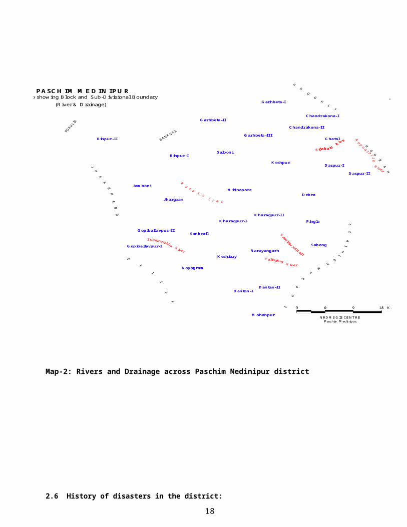
Map-2: Rivers and Drainage across Paschim Medinipur district
Map-3: River & Drainage Map; Jhargram Sub-Division
Map-4: River & Drainage Map; Ghatal Sub-Division
Map-5: River & Drainage Map; Medinipur Sadar Sub-Division
Map-6: River & Drainage Map; Kharagpur Sub-Division
LIST OF ANNEXURES
ANNEXURE-I NON GOVERNMENT ORGANISATION AND ACTIVITIESANNEXURE-II GP LEVEL CONTACT PERSONS
IIA MEDINIPUR SADAR SUB-DIVISIONIIB JHARGRAM SUB-DIVISIONII C GHATAL SUB-DIVISIONIID KHARAGPUR SUB-DIVISION
ANNEXURE-III BLOCK AND MUNICIPALITY WISE POPULATION - CENSUS 2001ANNEXURE-IV DISASTER MANAGEMENT TELEPHONE DIRECTORY
7

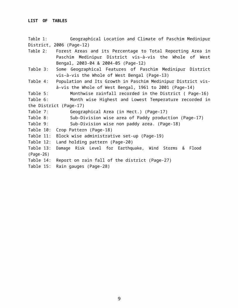
LIST OF TABLES
Table 1: Geographical Location and Climate of Paschim Medinipur District, 2006 (Page-12)Table 2: Forest Areas and its Percentage to Total Reporting Area in Paschim Medinipur District
vis-à-vis the Whole of West Bengal, 2003-04 & 2004-05 (Page-12)Table 3: Some Geographical Features of Paschim Medinipur District vis-à-vis the Whole of West
Bengal (Page-13)Table 4: Population and Its Growth in Paschim Medinipur District vis-à-vis the Whole of West
Bengal, 1961 to 2001 (Page-14)Table 5: Monthwise rainfall recorded in the District ( Page-16)Table 6: Month wise Highest and Lowest Temperature recorded in the District (Page-17)Table 7: Geographical Area (in Hect.) (Page-17)Table 8: Sub-Division wise area of Paddy production (Page-17)Table 9: Sub-Division wise non paddy area. (Page-18)Table 10: Crop Pattern (Page-18)Table 11: Block wise administrative set-up (Page-19)Table 12: Land holding pattern (Page-20)Table 13: Damage Risk Level for Earthquake, Wind Storms & Flood (Page-26)Table 14: Report on rain fall of the district (Page-27)Table 15: Rain gauges (Page-28)
CHAPTER-1
8
INTRODUCTION1.1 Background
The word Disaster means a catastrophe, mishap, calamity or grave occurrence in any area, arising from natural or man-made causes, or by accident or negligence which results in substantial loss of life or human suffering or damage to, and destruction of, property, or damage to, or degradation of environment, and is of such a nature or magnitude as to beyond the coping capacity of the community of the affected area. (Disaster Management Act, 2005)
The world is becoming increasingly vulnerable to natural disasters as well as man-made. From tsunamis and earthquakes to floods and famines, mankind is ever more threatened by the forces of nature. With almost a billion people now living in unplanned urban shanty towns, with deforestation wrecking ecological defence against catastrophic natural events, and with global warming making the force of wind, rain and sun harder to predict and counter, the world is at risk as never before.
In the Indian context the country has been traditionally vulnerable to natural disasters on account its unique geo-climatic condition. Floods, droughts, cyclones, earthquake, and landslides have been recurrent phenomena. About 60% of landmass is prone to earthquake of various intensities, over 40 million hectare is prone to flood, about 8% of the total area is prone to cyclone and 68% of the area is susceptible to drought. In the decade 2000-2010, an average of about 4344 people lost their lives and about 30 million people were affected by disaster every year. The lost in terms of private, community and public asses has been astronomical.
1.2 Changing Context of Disaster Management and Enactment of DM Act in India and West Bengal
A profound change in governmental disaster management has occurred during the last decades. Gone are the days of “hunkering down” and riding out the hazard event with a command and control mentality that only focused on clean-up and the rescue of survivors. In its place is an emphasis on the reduction of loss of life and property through mitigation, preparedness, response, and recovery.
The Government of India, in recognition of the importance of Disaster Management (DM) as a national priority, on 23 December 2005 took a defining step by enacting the Disaster Management Act. This is a unique legislation which provides for requisite institutional mechanism for drawing up and monitoring the implementation of the disaster management plans, ensuring measures by various wings of the Government for prevention and mitigating effects of disaster and for undertaking a holistic, coordinate and prompt response to any disaster situation.
The state of West Bengal has already adopted National Disaster Management Act, 2005. Chapter IV of DM Act, 2005 mandates every district in the country to constitute a District Disaster Management Authorities. Articles 31 of DM Act, section of the DM Act, 2005 provides that “there shall be a plan for disaster management for every district of the state. The district plan shall be prepared by the District Authority, after consultation with the local authorities, covering HRVA measures to be taken for prevention with the local authorities, covering HRVA measures to be taken for prevention and mitigation of disaster, capacity building and preparedness measures and response plan. The response plan includes
9

allocation of responsibilities to the depth at local to district level; prompt response and relief, procurement of essential resources; establishment of communication link, and public awareness”. Subsection of Article 31 says that the district plan shall be received and update annually.
1.3 Methodology of Developing District Disaster Management Plan
METHODOLOGY OF PLAN DEVELOPMENT
Data collection from all line departments Data analysis Discussion with experts Referring national and international literatures Preparation of action plans for departments Preparing draft plan document Mock drill to check the viability and feasibility of implementation methodology Wide circulation for public and departmental comments Preparation of the final plan document
1.4 Objectives and strategies of the plan
The major objective of the disaster management plan is to minimize the impact of any disaster and increase the capacity of the administration to have coordinate effort to reduce the impact of any disaster and minimize the human and capital loss.
To find out the type of risks the district is vulnerable to. To measure the vulnerability of life and livelihood and infrastructures to different type of risks. To develop a multi-hazard preparedness plan for effective management of different
type of disasters the district is vulnerable to. Institutionalization of the disaster management in district administration To develop strategy for mass awareness on do’s and don’ts on different type of disasters. To find out the resources of the district. To create a cadre of skilled volunteers to respond to different type of disasters. To make inter-departmental coordination more effective at the time of emergency. Encouragingand empowering the local community to own the disaster
management Regular update of the resource available in and around the district. To strengthen the capacities and resilience of vulnerable community with special emphasis on empowerment of women and establish community level systems for pre, during and post disaster interventions through awareness generation and capacity building
1.5. Nodal ministries related to various categories of disasters
Earthquakes and Tsunami- MHA/Ministry of Earth Sciences/IMD
10

Floods- MHA/Ministry of Water Resources/CWC Cyclones- MHA/Ministry of Earth Sciences/IMD Drought- Ministry of Agriculture Biological Disasters- Ministry of Health and Family Welfare Chemical Disasters- Ministry of Environment & Forests Nuclear Disasters- Department of Atomic Energy Air Accidents- Ministry of Civil Aviation Railway Accidents- Ministry of Railways Terrorism, bomblast, Riots- Ministry of Home Affairs
1.6. Importance of Disaster Management Plan
It is apparent that this district is prone to natural disasters such as floods, earthquake etc. also, it cannot ignore the man-made disasters. So the district plan is designed as per the present need and the major strategies to respond to any unexpected situation have also been considered. In the district Disaster Management plan, all the disasters will be handled properly following the given response mechanism, like Incident Response System (IRS), use of resource inventory, Standard Operative Procedures (SOP), keeping coordinate with the line agencies and proper community based awareness activities. SOP of line departments is designed to make them alert. It highlights their role and responsibilities during, after and normal time of the disaster.
1.7 The main features of Disaster Management plan:
1. It gives importance to all the disasters equally and helps to mitigate the situation beforehand.2. All the departments are assigned with their proper role and responsibilities, which are clearly indicated
in the SOPs.3. The District administration has to be alert round the year as disasters may occur anytime, anywhere in
the in the district, irrespective of time and location.
11
CHAPTER-2DISTRICT PROFILE
2.1 Location and boundaries:
Paschim Medinipur, located in the southern part of West Bengal, has been carved from the erstwhile Medinipur district, the then largest district of India, and came into existence in the present form from 1 st
January 2002. It is situated between 220 57’ 10” and 210 36’ 35” North latitude and between 880 12’ 40” and 860
33’ 50” East longitude. Paschim Medinipur is bounded by Bankura district from the northern side and Purba Medinipur district from the south-eastern side The southern boundary of the district is merged with Balasore and Mayurbhanj district of Orissa and western boundary is merged with Singbhum and east district of Jharkhand.
The present population of the district is 57 lakh with 18.05 % SC and 14.87 % ST population. Geographical area of the district is 9295.28 Sq. Km. The district is further divided into four Sub-dvisions, 29 blocks and 8 municipalities.
12
Salboni
Binpur-II
Debra
Keshpur
Jhargram
Nayagram
Binpur-I
SabongNarayangarh
SankrailPingla
Ghatal
Garhbeta-I
Jamboni
Garhbeta-II
Midnapore
Dantan-I
Kharagpur-I
Garhbeta-III
Dantan-II
Daspur-IDaspur-II
Gopiballavpur-I
Chandrakona-I
Mohanpur
Gopiballavpur-II
Keshiary
Kharagpur-II
Chandrakona-II
West Bengal
Paschim Medinipur District(Map showing Blocks)
N
10 0 10 20 Kilometers
Paschim Medinipur
NRDMS, Paschim Medinipur
Map-I : District Map of Paschim Medinipur showing Blocks.
2.2 Multifarious Regional Diversity: Paschim Medinipur district represents regional diversity in terms of physiographic, agro-climatic characteristics, economic development, social composition etc. Geo-morphologically, the district can be sub-divided into three parts, viz. Chhotonagpur Flanks with hills, mounds and rolling lands in the westernmost part, Rahr Plain with lateritic uplands in the middle part and Alluvial plain of the east with recent deposits. It is hilly in the north-west but represents low basins in the south-east and east. It has drought-affected dry areas in the west but highly wet flood-affected in the east. Dense dry deciduous forest in the west is replaced by semi-aquatic vegetations of marsh lands in the east. It has barren lateritic, non-arable lands in the west and north-west, which gradually changes with highly productive alluvial soil areas in the central and eastern part of the district. It is the abode of tribes and primitive tribes in the western blocks while most of the other areas are inhabited by all castes of the mass society. It represents cultural diversity across blocks.
2.3 Topography: The area of the district is 9295.28 Sq. Km. The general appearance of the district is that of a large and well-cultivated plain, but towards the north and west gently undulations appear, with ridges covered by a thick growth of sal trees and other scrub jungle, while the intervening depression produces rich crops of rice. Partly from the poor fertility of the soil, and also from the ruthless way forest have been cut down in past, large forest trees are scares, but still in the neighborhood of some of the villages, a few fine tamarind, sal and mahua trees still do remain. The western boundary is more broken and picturesque, for the lower ranges of the Chhotanagpur Hills line the horizon, the jungle assumes the character of forest, and large trees begin to predominate. The soil, however, is lateritic, a considerable area is unproductive, almost uninhabited, especially in the extreme north-west where there are several hills over 1000 feet in height. The remainder of the country is an almost level plain broken only by the sand hills.
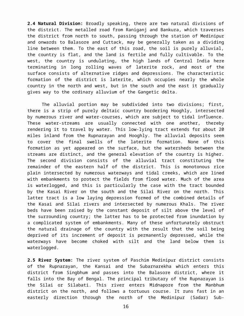
2.4 Natural Division: Broadly speaking, there are two natural divisions of the district. The metalled road from Raniganj and Bankura, which traverses the district from north to south, passing through the station of Medinipur and onwards to Balasore and Cuttack, may be generally taken as a dividing line between them. To the east of this road, the soil is purely alluvial, the country is flat, and the land is fertile and fully cultivable. To the west, the country is undulating, the high lands of Central India here terminating in long rolling waves of laterite rock, and most of the surface consists of alternative ridges and depressions. The characteristic formation of the district is laterite, which occupies nearly the whole country in the north and west, but in the south and the east it gradually gives way to the ordinary alluvium of the Gangetic delta.
The alluvial portion may be subdivided into two divisions; first, there is a strip of purely deltaic country bordering Hooghly, intersected by numerous river and water-courses, which are subject to tidal influence. These water-streams are usually connected with one another, thereby rendering it to travel by water. This low-lying tract extends for about 20 miles inland from the Rupnarayan and Hooghly. The alluvial deposits seem to cover the final swells of the laterite formation. None of this formation as yet appeared on the surface, but the watersheds between the streams are distinct, and the general elevation of the country is higher. The second division consists of the alluvial tract constituting the remainder of the eastern half of the district. This is monotonous rice plain intersected by numerous waterways and tidal creeks, which are lined with embankments to protect the fields from flood water. Much of the area is waterlogged, and this is particularly the case with the tract bounded by the Kasai River on the south and the Silai River on the north. This latter
13

tract is a low laying depression formed of the combined details of the Kasai and Silai rivers and intersected by numerous Khals. The river beds have been raised by the constant deposit of silt above the level of the surrounding country; the latter has to be protected from inundation by a complicated system of embankments. Many of these unfortunately obstruct the natural drainage of the country with the result that the soil being deprived of its increment of deposit is permanently depressed, while the waterways have become choked with silt and the land below them is waterlogged.
2.5 River System: The river system of Paschim Medinipur district consists of the Rupnarayan, the Kansai and the Subarnarekha which enters this district from Singbhum and passes into the Balasore district, where it falls into the Bay of Bengal. The principal tributary of the Rupnarayan is the Silai or Silabati. This river enters Midnapore from the Manbhum district on the north, and follows a tortuous course. It runs fast in an easterly direction through the north of the Medinipur (Sadar) Sub-division, and then turns to the south east and south through the Ghatal Sub-division. Near Narajole it takes a sharp turn to the north, and eventually it falls into the Rupnarayan at Bhandar, 4 miles below Ghatal. The Silai is navigable throughout the year for a short distance in its lower reaches, which are within tidal influence. It is fed by two small streams from Bankura district on the north, the Purandar and Gopa, and by the Chandur and Kubai in Medinipur its rise in the north-west of the district and flows east till it empties itself into the Silai near Narajole. The Kasai enters the district in the north-west from Bankura. It flows an exceedingly tortuous course, running first south and south–west and then eastwards past the town of Medinipur, which is situated on its north bank. Below Medinipur the channel contracts rapidly, till at Kapastikti, 13 miles lower down, it bifurcates, one small branch going north and eventually into the Rupnarayan, while the main channel runs south-east. The Subarnarekha is the only other river of Paschim Midnapore requiring notice. It enters the district on the north-west from Dhalbhum and pass through the south-west of Medinipur (Sadar) sub-division intersecting Gopiballavpur thana. To the South of Dantan it enters Balasore district and finally falls into the Bay of Bengal. The Subarnarekha has a rapid stream with a sandy bed, and its banks are generally high and well defined. In seasons of high flood the river overflows it’s left bank about 4 miles above the point where it leaves Paschim Medinipur district to enter Balasore district. The Dulongs is also an important river of the district.
14

Map-2: Rivers and Drainage across Paschim Medinipur district
15
Binpur-II
Chandrakona-I
Chandrakona-II
Garhbeta-I
Dantan-IDantan-II
Daspur-I
Daspur-II
Debra
Garhbeta-II
Garhbeta-IIIGhatal
Gopiballavpur-I
Gopiballavpur-II
Jamboni
Jhargram
Keshiary
Keshpur
Kharagpur-IKharagpur-II
Mohanpur
Narayangarh
Nayagram
Pingla
Sabong
Salboni
Sankrail
Binpur-I
Midnapore
PASCHIM MEDINIPUR N
EW
S
9 0 9 18 Kilometers
District Map showing Block and Sub-Divisional Boundary
NRDMS GIS CENTREPaschim Medinipur
(River & Drainage)
e
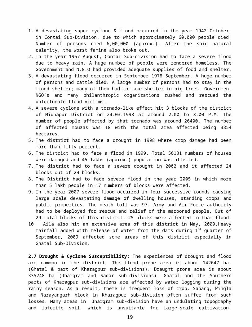
2.6 History of disasters in the district:
1. A devastating super cyclone & flood occurred in the year 1942 October, in Contai Sub-Division, due to which approximately 60,000 people died. Number of persons died 6,00,000 (approx.). After the said natural calamity, the worst famine also broke out.
2. In the year 1967 August, Contai Sub-division had to face a severe flood due to heavy rain. A huge number of people were rendered homeless. The Government and N.G.O had provided adequate supplies of food and shelter.
3. A devastating flood occurred in September 1978 September. A huge number of persons and cattle died. A large number of persons had to stay in the flood shelter; many of them had to take shelter in big trees. Government NGO’s and many philanthropic organizations rushed and rescued the unfortunate flood victims.
4. A severe cyclone with a tornado-like effect hit 3 blocks of the district of Midnapur District on 24.03.1998 at around 2.00 to 3.00 P.M. The number of people affected by that tornado was around 26400. The number of affected mouzas was 18 with the total area affected being 3854 hectares.
5. The district had to face a drought in 1998 where crop damage had been more than fifty percent.6. The district had to face a flood in 1999. Total 56131 numbers of houses were damaged and 45 lakhs
(approx.) population was affected.7. The district had to face a severe drought in 2002 and it affected 24 blocks out of 29 blocks.8. The District had to face severe flood in the year 2005 in which more than 5 lakh people in 17 numbers of
blocks were affected.9. In the year 2007 severe flood occurred in four successive rounds causing large scale devastating damage of
dwelling houses, standing crops and public properties. The death toll was 97. Army and Air Force authority had to be deployed for rescue and relief of the marooned people. Out of 29 total blocks of this district, 25 blocks were affected in that flood.
10. Aila also hit an extensive area of this district in May, 2009.Heavy rainfall added with release of water from the dams during 1st quarter of September, 2009 affected some areas of this district especially in Ghatal Sub-Division.
2.7 Drought & Cyclone Susceptibility: The experiences of drought and flood are common in the district. The flood prone area is about 142647 ha. (Ghatal & part of Kharagpur sub-divisions). Draught prone area is about 335248 ha (Jhargram and Sadar sub-divisions). Ghatal and the Southern parts of Kharagpur sub-divisions are affected by water logging during the rainy season. As a result, there is frequent loss of crop. Sabang, Pingla and Narayangarh block in Kharagpur sub-division often suffer from such losses. Many areas in Jhargram sub-division have an undulating topography and laterite soil, which is unsuitable for large-scale cultivation. Drought affects the population here frequently and causes damage to the limited agriculture in the area, affecting food security of the people living here. Though the district does not have a coastline, it is affected frequently by the cyclones during the months of October and November and untimely rains during April and May.
The climate is tropical and the land surface of the district is characterized by hard rock uplands, lateritic covered area, and flat alluvial and deltaic plains. Extremely rugged topography is seen in the western part of the district and rolling topography is experienced consisting of lateritic covered area. These rolling
16

plains gradually merge into flat alluvial and deltaic plains to the east and south east of the district. The soil is fairly fertile.
2.8 Account of precipitation & temperature: Normal rainfall in the district is around 1400 – 1500 mm. However, for the last few years, it has been highly erratic in nature.
Average temperature of the district varies widely across seasons, varying between maximum of 39
degree Celsius and minimum 10 degree Celsius in 2006. The climate is characterized by hot summer, cold winter, abundant rainfall and humidity. Rainfall fluctuates widely over years and concentrates over a few months of a year under monsoon. Normal rainfall estimated over 21 years during 1994 to 2005 is 1549 mm.
Latitude LongitudeTemperature (Degree
Celsius) 2006Rainfall Normal (m.m.) 2006
Rainfall Actual (m.m.)
Rainfall Actual (m.m.)
North South East West Maxi-mumMini-mum
2002 2006
22057/
10//
21036’
35//88012/ 40//
86033/
50//39 10 1537 1663 1436
Table-1 : Geographical Location and Climate of Paschim Medinipur District, 2006
Source: Government of West Bengal, District Statistical Handbook, Paschim Medinipur 2006
2.9 Some Indicators of Paschim Medinipur vis-à-vis the whole of West Bengal It ranks 1st among 19 districts of the state of West Bengal in sex ratio (961) followed by Bankura and Purulia
(953), Murshidabad (952), Dakshin Dinajpur (950), the all-West Bengal average being 934 in 2001. It ranks 2nd in terms of geographical area (9295.28 sq. km.), next to South 24-Parganas (9960 sq. km.) but is
followed by Burdwan (7024 sq. km.) and Bankura (6882 sq. km.) It ranks 3rd in terms of rural population (45.76 lakh) following South 24-Parganas ( 58.20 lakh) and
Murshidabad (51.33 lakh) but is followed by Burdwan (43.48 lakh), North 24-Parganas ( 40.83 lakh) and Purba Medinipur ( 40.51 lakh) as in 2001.
It ranks 4th in terms of percentage of ST population (14.87) following Jalpaiguri ( 18.87), Purulia (18.27) and Dakshin Dinajpur (16.12).
2.10 Natural Resources: Paschim Medinipur is rich in a variety of environmental resources like land, forest and human resources. As per Census of India, total geographical area of Paschim Medinipur district in 2001 (9.75 thousand sq. km.) accounted for 11.01 per cent of the total geographical area of the state (88.75 thousand sq.km.). Total forest area of the district was 1.70 thousand sq. km. which accounted for 14.31 per cent of the total forest area of the state (11.88 thousand sq. km.).
District/State
2003-04 2004-05
Reporting area(‘000hectares)
Forest area(‘000hectares)
Percentage of forest to Reporting
area
Reporting area(‘000hectares)
Forest area(‘000hectares)
Percentage of forest to
Reporting area
17
Paschim Medinipur 928.6 169.7 18.27 928.6 171.9 18.51West Bengal 8687.5 1171.3 13.48 8687.5 1174.8 13.52Per Cent 10.69 14.49 136 10.69 14.63 137
Table 2: Forest Areas and its Percentage to Total Reporting Area in Paschim Medinipur District vis-à-vis the Whole of West Bengal, 2003-04 & 2004-05 Source: Government of West Bengal, District Statistical Handbook, Paschim Medinipur 2006
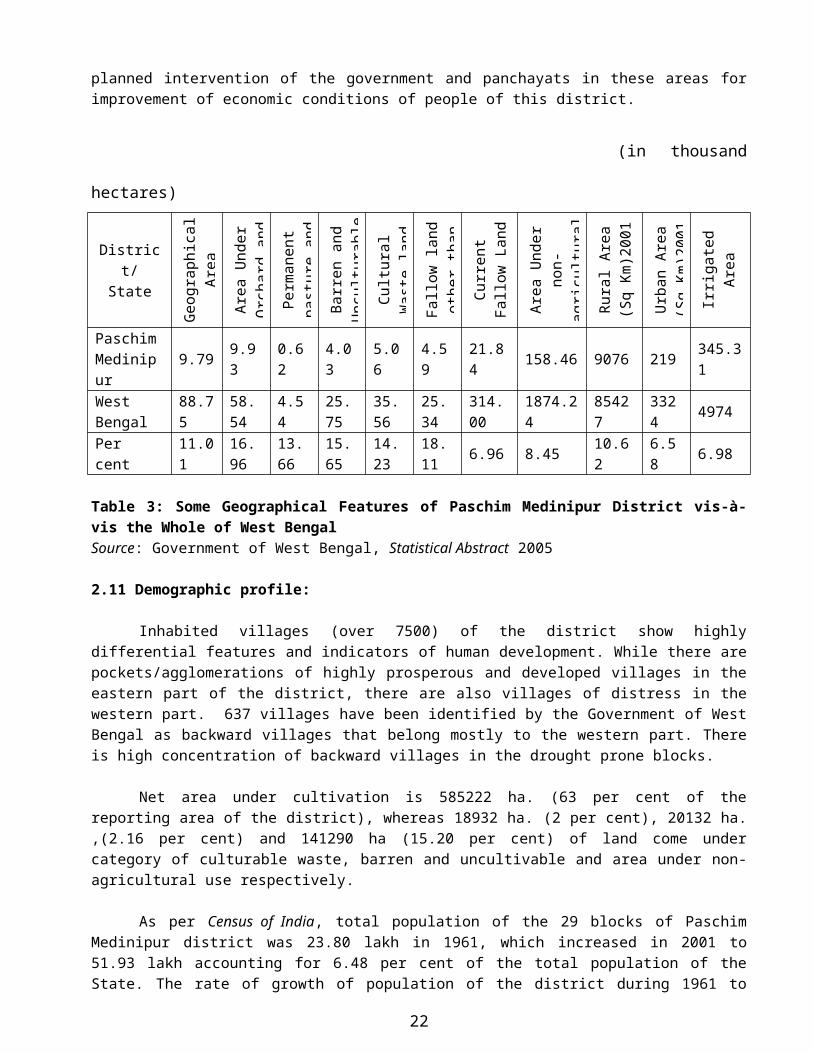
Similarly, percentage shares of the district to all West Bengal area under orchard, permanent pasture and grazing land, barren and unculturable waste, culturable waste, fallow land other than current fallow were above its percentage share to its geographical area. Percentage shares of the district in non-agricultural area, urban area, and irrigated area were, however, below that in geographical area of the State, which indicates that there is deficiency of the district in these indicators and demands planned intervention of the government and panchayats in these areas for improvement of economic conditions of people of this district.
(in thousand hectares)
District/ State
Geog
raph
ical
Are
a (‘0
00 sq
. km
.)
Area
Und
er
Orc
hard
and
oth
er
Perm
anen
t pa
stur
e an
d
Barr
en a
nd
Unc
ultu
rabl
e
Cultu
ral W
aste
la
nd
Fallo
w la
nd o
ther
th
an C
urre
nt
Curr
ent F
allo
w
Land
Area
Und
er n
on-
agric
ultu
ral u
se
(200
4-05
)
Rura
l Are
a (S
q Km
)200
1
Urb
an A
rea
(Sq
Km)2
001
Irrig
ated
Are
a (‘0
00 h
ecta
res)
20
02-0
3
Paschim Medinipur
9.79 9.93 0.62 4.03 5.06 4.59 21.84 158.46 9076 219 345.31
West Bengal
88.75 58.54 4.54 25.75 35.56 25.34 314.00 1874.24 85427 3324 4974
Per cent 11.01 16.96 13.66 15.65 14.23 18.11 6.96 8.45 10.62 6.58 6.98
Table 3: Some Geographical Features of Paschim Medinipur District vis-à-vis the Whole of West BengalSource: Government of West Bengal, Statistical Abstract 2005
2.11 Demographic profile:
Inhabited villages (over 7500) of the district show highly differential features and indicators of human development. While there are pockets/agglomerations of highly prosperous and developed villages in the eastern part of the district, there are also villages of distress in the western part. 637 villages have been identified by the Government of West Bengal as backward villages that belong mostly to the western part. There is high concentration of backward villages in the drought prone blocks.
Net area under cultivation is 585222 ha. (63 per cent of the reporting area of the district), whereas 18932 ha. (2 per cent), 20132 ha. ,(2.16 per cent) and 141290 ha (15.20 per cent) of land come under category of culturable waste, barren and uncultivable and area under non-agricultural use respectively.
As per Census of India, total population of the 29 blocks of Paschim Medinipur district was 23.80 lakh in 1961, which increased in 2001 to 51.93 lakh accounting for 6.48 per cent of the total population of the State. The rate of growth of population of the district during 1961 to 1971 was 27.52 per cent, which has come down to 15.76 per cent during 1971 to 2001. The decadal growth rate of population of the district during 1971
18
to 2001 was below that of the State as a whole.
District/ State
Population (in lakh)Growth rate of population (Per
cent)
1961 1971 1981 1991 20011961-71
1971-81
1981-91
1991-01
Paschim Medinipur
23.80 30.35 36.97 48.46 51.93 27.52 21.81 21.34 15.76
West Bengal
349.26 443.12 545.81 680.78 801.76 26.87 23.17 24.73 17.77
Per cent 6.81 6.85 6.77 6.59 6.48 102.42 94.13 86.29 88.69 Table 4: Population and Its Growth in Paschim Medinipur District vis-à-vis the Whole of West Bengal, 1961 to 2001Source: Census of India, West Bengal, Relevant Issues
DEMOGRAPHIC FEATURES BPL Information (2002)Population (Census 2001) 5193411 Total Rural Families 1058290Male 2648048 Total BPL Families 349745Female 2545363 % of BPL families 32.88%Scheduled Castes 18.07%Scheduled Tribes 14.87% Birth Rate ( Per 1000) 2.00 (2002)Rural Population 4686264 Death Rate ( Per 1000) 7.30 (2002)Urban Population 507147 Infant Mortality Rate 55 (2002)
Mother Mortality Rate 1.4Area (in Sq.K.M.) 9295.28 Couple Protection Rate 59%Urban 218.85 Life expectancy at Birth 67.5 yrs.Rural 9076.43
FISHERIESTotal Households (2001) 900700 Total water area 18824hec.
Decennial Growth Rate 16.32% Ponds / Tanks 18420 hec.Density of population (Per Sq.k.m.) 561.4 River and canals 11000 hec.Sex Ratio 962 Bills and Boars 404.00 hec.(No. of Female per 1000 Male) Total Fisherman (in No.) 31500Total Mouza 8735 Fish ProductionInhabited 7498 Fish Seed 80.12 croresUninhabited 1237 Table Fish 48000 M.T.Total Town 14 Fishermen Co-Operatives & Groups 214Municipality 8 a) Primary 23Non - Municipal Town 6 b) Central 1
19

Literacy Rate (2001) 60.70% c) Groups 190Male 70.13% Fisherman Model Village 3Female 50.90% Fishermen Houses through IAY 495
Requirement of Table Fish 48000M.T.MINOR IRRIGATION SOURCESDeep Tube Wells (DTW) 141 ANIMAL RESOURCE DEV.Area irrigated 4975 Hec. Total Cattle 17.03 lakhHigh Discharge Tube Wells (HDTW) 72 Buffalo 0.59 lakhArea irrigated 2611 Hec. Goat 8.84 lakhMedium Duty Tube Wells 40 Fowl 24.83 lakhArea irrigated 813 Hec. Duck 4.48 lakhLow Duty Tube Wells 442 Pig 1.00 lakhArea irrigated 1686 Hec. Milk ProductionSurface Flow Irrigation 8 Egg Production 153.79 MillionArea irrigated 2685 Hec.River Lift Irrigation 367Area irrigated 18719 Hec.AGRICULTURE (in acres) ELECTRIFICATION Net area under cultivation 585222 Total Mouza 8735Area under forest 173038 Inhabited Mouza 7478Area under orchard & other 3855 Mouza Electrified 4654
-62.24%Barren & uncultivable land 20132 132 K.V. Sub-Station 4
33 K.V. Sub-Station 23Fallow & other current fallow 25072 Total Dom. / Comm. / Ind. Consumer 136448Area under non-agrl use 144403 Decentralised Bulk Consumer 95Gross Cropped area 989813 Total load demand 210 MVACropping Intensity 172% Lokedeep 3041Net irrigated area 298672 PHE 104 % on net area 52%Production ( 2005-06) LAND & LAND REFORMS Cereals (Aush,Amon, Boro, Wheat, Maize) Total agril land vested 256159.67 AcreArea (in thousand hec.) 683.291 Vested land distributed 192050.04 AcreProduction (in M.T.) 17,74,142 Patta Holders 652331 Nos.Pulses ( Kalai, Mug, etc. ) Bargadars recorded 149173 Nos.Area (in thousand hec.) 15.013 Land owned by Bargadar 76874 AcreProduction (in thousand M.T.) 11.622 Collection on Revenue & Cess (31/03/04) 4.21CroreOil Seeds ( Mustered, Til, Ground Nut Collection on Minor Minerals 9.68 CroreArea (in thousand hec.) 81.293Production (in thousand M.T.) 85.555 PANCHAYAT & R.D.Potato Zilla Parishad 1Area (in thousand hec.) 72.885 Panchayat Samity 29Production (in thousand M.T.) 1610.39 Gram Panchayat 290Vegetables(Bhadoi, Winter, Summer) Gram Sabha 290
20

Area (in thousand hec.) 56.45 Average Electors per Gram Sabha 9427Production (in thousand M.T.) 565.6 Gram Sansad 3491Jute Average Electors per Gram Sansad 787Area (in thousand hec.) 4.22Production (in thousand M.T.) 7.935 COTTAGE & S.S.I Sugarcane Registered SSI (31.03.03) 7606Area (in thousand hec.) 4.06 Employment 40398Production (in thousand M.T.) 309.58 Unemployed assisted in PMRY 1874EDUCATIONPrimary Education HandloomNo. of Circles 65 Total Handlooms 10120Govt. aided Primary Schools 4622 Registered Handloom Co-Operative 117 Total Students 449096 lakh Looms under Co-Operative 8059 Total Teachers 11377 S.C. Weavers' Co-Operative 623Sishu Siksha Kendra 2496 Weavers benefited in : Total Students 116199 lakh a) Old age Pension 60Sahayaks/Sahayikas 5559 b) CPF/ Thrift Fund 538Anganwadi Centres 4535 c) Work Shed Scheme 478Special School for Child Labour 28 d) Medical facilities 339Upper Primary Schools 747 e) Group Savings 76PTTI 3 SericultureSecondary Education Area under Mulberry cultivation 977.34AcresTotal Secondary School 747 Area under Tasar cultivation 1659 AcresCo-Education/Boys 658 Farmers engaged in :Girls 89 a) Mulberry 1642Higher Secondary 151 b) Tasar 1566High School 362Jr. High 219 HEALTH & FAMILY WELFARESr. Madrash ( Co-ed) 3 Medinipur Medical College Hospital 1High Madrash ( Co-ed) 5 Sub-Divisional Hospital 3Jr. Madarash 7 Rural Hospital 9Others Educational Institutions BPHC 20Teachers’ Training Institute 3 P.H.C 82College (Degree) 19 Sub-Centre 858University ( V.U.) 1 T.B. Sanatorium 1No of Medical Colleges 1 Urban Family Welfare Centre
Leprosy Control Unit29No. of Homoeopathic Medical College 1
I.I.T. ( KGP) 1 State Homoeo Centre 40No of I. T. I. 2 State Medical Unit 1No of Polytechnics 1 WATER SUPPLY & SANITATIONTotal Library 158 No. of Rural Water Supply functioning 22
Rural Population covered 2.59 lakhSanitary Latrine availed families (June,01) 2.35No. of Tube Well 45
21
Mouza covered 205
2.12 Land Use Pattern, Cropping Intensity and Irrigation
Distribution of geographical area of the district and land use pattern across shows that Binpur-II block has the largest geographical area followed closely by Jhargram and Salboni and the smallest block being Mohanpur.
Narayangarh block records the largest net cropped area, the smallest being again Mohanpur. Area under pasture and orchard is largest in Salboni followed by Jhargram, the smallest being observed again
in Mohanpur. It is revealed that Pingla block recorded in 2005-06 the highest cropping intensity (199 per cent) followed by
Daspur-I, Sabang and Garbeta-I, Jhargram. Sankrail and Jamboni registering the lowest.
The Kangsabati Dam located on the Kumari and Kangsabati River at Mukutmonipur in Bankura District is the main irrigation scheme which provides water in agrarian fields for both Kharif and Rabi crops.
Ground water supports by dint of deep tubewells and shallow tubewells serve as supplementary irrigation.
Sl. No. MonthAverage Rainfall
(in mm)Actual Rainfall in 2010
(in mm)Current year rainfall
(in mm)1. January 14.8 0 4.7
2. February 27.6 6.3 7.6
3. March 38.1 7.7 56.3
4. April 48.2 4.5 76.0
5. May 138.2 107.3 84.0
6. June 242.0 185.4 8.8
7. July 323.1 209.2 -
8. August 312.5 153.8 -
9. September 235.8 222.7 -
10. October 124.9 103.3 -
11. November 28.0 0.9 -
12. December 4.8 0.0 -
Total 1538.0 1001.1 237.4 up to 05.06.11
Table 5: Monthwise rainfall recorded in the DistrictRain Recording Station:-i) Total Number of Rain recording stations in Paschim Medinipur District.a) Midnapore SCRS [ at Abash, Midnapore] Ph No.-03222-275680b) Jhargram SARF [ at Jamda, Jhargram] Ph No.-03221-255243c) Pingla SARF [ on Mundamari-Moyna Road, near Mundamari] Ph No.03222-217812d) Khirpai SARF [ on Khirpai-Arambagh Road, near Khirpai] Ph No.03225-249732 [of the Asstt. Director of Agril (Sabong Block)]e) Sabong BSF [ near Barjiban on Temathani-Sabong Road]
Ph No.03222-249732 [ of the Asstt. Director of Agril (Sabong Block)]
22

Sl. No
MonthMaximum Temperature (in Centigrade)
Minimum Temperature (in Centigrade)
1. January 27.5 13.82. February 31.0 15.63. March 34.9 19.84. April 39.4 24.25. May 36.3 24.86. June 34.1 26.47. July 32.4 24.68. August 33.0 26.49. September 33.1 26.010. October 31.7 21.311. November 29.8 17.912. December 27.1 12.9
Table 6: Month wise Highest and Lowest Temperature recorded in the District:-
Sl. No
Name of the Sub-division
Agricultural Land (ha)Grazing land
Forest Land (ha)
OthersTotal areaHigh Medium Low
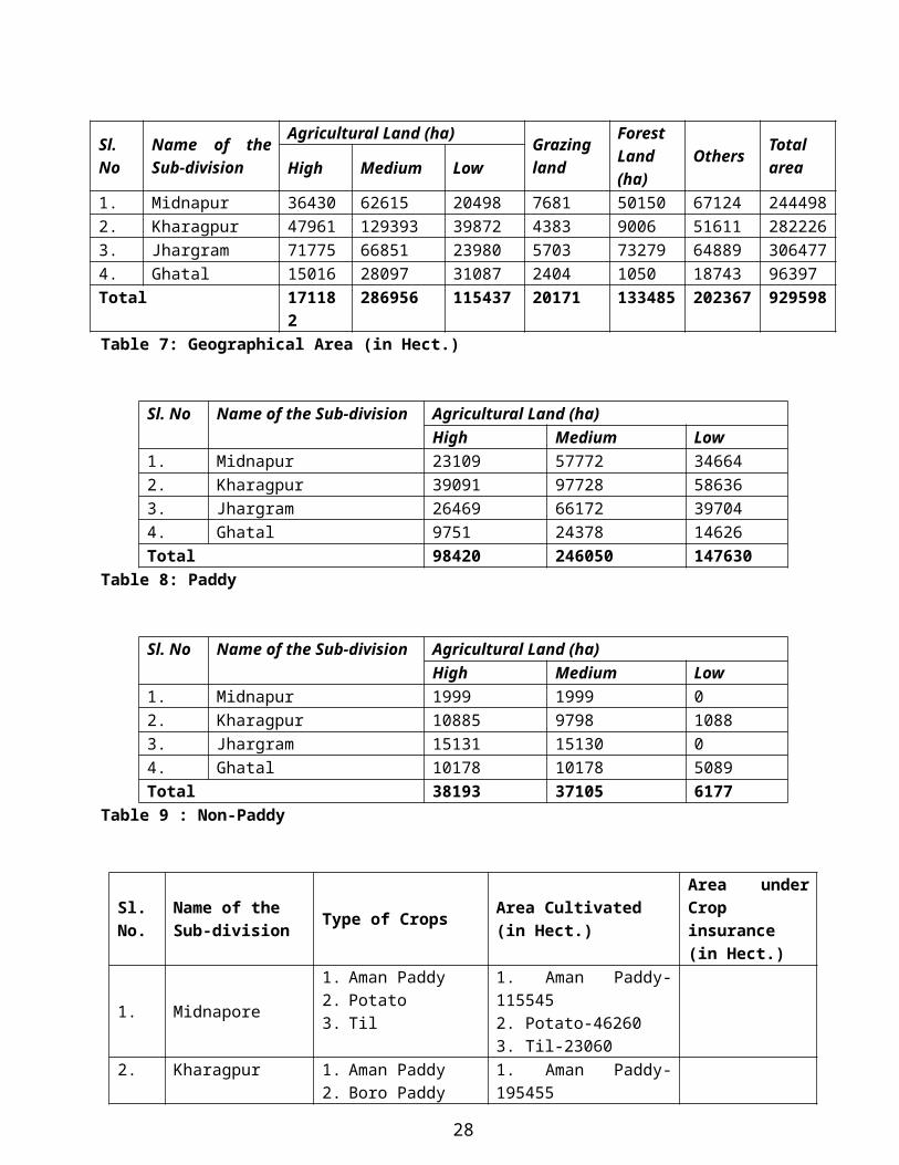
1. Midnapur 36430 62615 20498 7681 50150 67124 2444982. Kharagpur 47961 129393 39872 4383 9006 51611 2822263. Jhargram 71775 66851 23980 5703 73279 64889 3064774. Ghatal 15016 28097 31087 2404 1050 18743 96397Total 171182 286956 115437 20171 133485 202367 929598Table 7: Geographical Area (in Hect.)
Sl. No Name of the Sub-division Agricultural Land (ha)High Medium Low
1. Midnapur 23109 57772 346642. Kharagpur 39091 97728 586363. Jhargram 26469 66172 397044. Ghatal 9751 24378 14626Total 98420 246050 147630
Table 8: Paddy
Sl. No Name of the Sub-division Agricultural Land (ha)High Medium Low
1. Midnapur 1999 1999 02. Kharagpur 10885 9798 1088
23

3. Jhargram 15131 15130 04. Ghatal 10178 10178 5089Total 38193 37105 6177
Table 9 : Non-Paddy
Sl. No.
Name of theSub-division
Type of CropsArea Cultivated(in Hect.)
Area under Crop insurance(in Hect.)
1. Midnapore1. Aman Paddy2. Potato3. Til
1. Aman Paddy-1155452. Potato-462603. Til-23060
2. Kharagpur1. Aman Paddy2. Boro Paddy
1. Aman Paddy-1954552. Boro Paddy-89295
3. Jhargram1. Aman Paddy2. Mustard3. Groundnut
1. Aman Paddy-1323452. Mustard-52303. Groundnut-9350
4. Ghatal
1. Aman Paddy2. Boro Paddy3. Potato4. Til
1. Aman Paddy-487552. Boro Paddy-272253. Potato-181504. Til-13205
Table 10: Crop Pattern
24
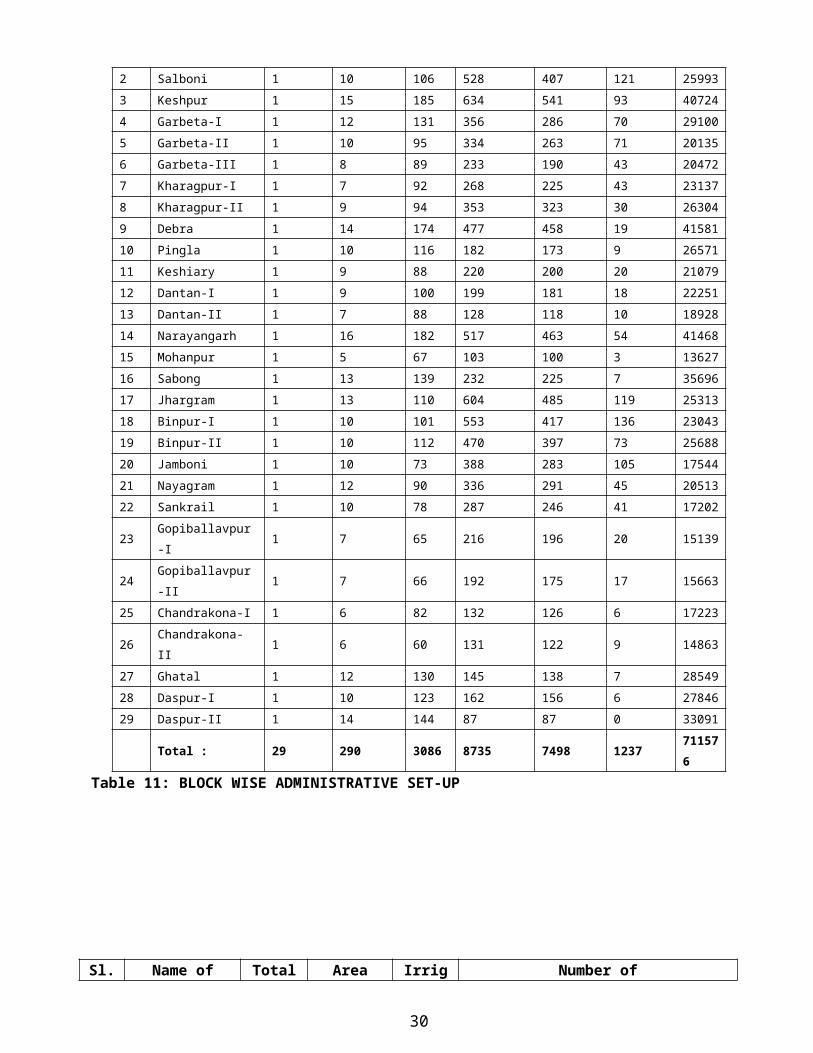
Sl.
No.Block name
Panchayat
MouzaInhabited
Mouza
No. of De-
populated
Mouza
No. of
House-
holdSamity Gram
Gram
Sansad
25
1 2 3 4 5 6 7 8 9
1 Midnapore Sadar 1 9 106 268 226 42 22833
2 Salboni 1 10 106 528 407 121 25993
3 Keshpur 1 15 185 634 541 93 40724
4 Garbeta-I 1 12 131 356 286 70 29100
5 Garbeta-II 1 10 95 334 263 71 20135
6 Garbeta-III 1 8 89 233 190 43 20472
7 Kharagpur-I 1 7 92 268 225 43 23137
8 Kharagpur-II 1 9 94 353 323 30 26304
9 Debra 1 14 174 477 458 19 41581
10 Pingla 1 10 116 182 173 9 26571
11 Keshiary 1 9 88 220 200 20 21079
12 Dantan-I 1 9 100 199 181 18 22251
13 Dantan-II 1 7 88 128 118 10 18928
14 Narayangarh 1 16 182 517 463 54 41468
15 Mohanpur 1 5 67 103 100 3 13627
16 Sabong 1 13 139 232 225 7 35696
17 Jhargram 1 13 110 604 485 119 25313
18 Binpur-I 1 10 101 553 417 136 23043
19 Binpur-II 1 10 112 470 397 73 25688
20 Jamboni 1 10 73 388 283 105 17544
21 Nayagram 1 12 90 336 291 45 20513
22 Sankrail 1 10 78 287 246 41 17202
23 Gopiballavpur-I 1 7 65 216 196 20 15139
24 Gopiballavpur-II 1 7 66 192 175 17 15663
25 Chandrakona-I 1 6 82 132 126 6 17223
26 Chandrakona-II 1 6 60 131 122 9 14863
27 Ghatal 1 12 130 145 138 7 28549
28 Daspur-I 1 10 123 162 156 6 27846
29 Daspur-II 1 14 144 87 87 0 33091
Total : 29 290 3086 8735 7498 123771157
6
Table 11: BLOCK WISE ADMINISTRATIVE SET-UP
Sl. Name of Block Total Area under Irrigate Number of
26

No.area (in Sq.Km.)
cultivation (hect.)
d area (hect.)
Small farmers
Marginal farmers
Patta holders
Bargadars
1 Midnapore 336.81 17700 3399 3800 12945 22326 53392 Salboni 559.41 24260 10268 8825 5960 9352 53973 Keshpur 481.5 37580 22678 10445 15360 16326 106594 Garbeta-I 356.84 19891 13915 2315 23573 19596 56405 Garbeta-II 445.48 20550 11631 8606 3690 17600 26396 Garbeta-III 305.62 18885 8235 3784 6773 33688 24467 Kharagpur-I 281.94 18500 4705 7542 12562 19022 29638 Kharagpur-II 271.46 20880 18508 7562 11245 13829 57019 Debra 342.29 28400 13659 20865 17123 21605 915310 Pingla 220.24 18262 14881 12222 8895 16890 398611 Keshiary 292.26 21030 10183 14315 20744 15838 376712 Dantan – I 252.16 20663 5710 4118 12687 16442 445213 Dantan – II 186.48 15887 4193 4297 7775 10552 256814 Narayangarh 504.02 40046 11325 7064 11391 25562 984215 Mohonpur 140.6 12000 6185 3132 8282 6742 174716 Sabang 308.53 21083 15858 1687 3233 19354 639017 Jhargram 539.64 28806 13034 6670 12875 26685 715518 Binpur-I 362.96 18763 7199 3696 13261 16358 326419 Binpur-II 576 22870 8885 6575 14513 21564 197320 Jamboni 326.6 20450 6862 4892 8625 16860 316421 Nayagram 503.15 22800 1920 822 11345 21754 207422 Sankrail 275.6 20760 10589 4748 5952 7373 329223 Gopiballavpur-I 172 15265 7695 1338 12255 19781 165824 Gopiballavpur-II 201.77 14652 5070 4700 9225 16361 312525 Chandrakona-I 214.16 17000 8795 2725 6498 11453 515726 Chandrakona-II 175.03 13100 7660 3186 8076 14395 489027 Ghatal 229.91 17900 11450 1370 3026 7710 685228 Daspur-I 166.58 13200 9390 1806 21587 5283 445929 Daspur-II 164.8 13000 9080 1075 22630 1533 2405
Total 9193.84 594183 282962 164182 332106 471834 132157
Table 12 : LAND HOLDING PATTERN
CHAPTER -3HAZARD, VULNERABILITY AND RISK ASSESSMENT
27
A Hazard, Risk and Vulnerability Assessment (HRVA) examine the hazards that may impact a community and the risk that each hazard event poses to the community as a whole and to vulnerable elements of the community. The objective of the Hazard, Vulnerability and Risk Analysis is to:
1. Investigate prominent natural and human caused events.2. Identity any threat that may require timely response to protect lives, property and reduce economic loss.3. Identity vulnerable groups who need more concern during any calamity.
3.1 WHAT IS A DISASTER
1. Disaster may be defined as an occurrence arising with little or no warning, which causes or threatens heavy loss of life and property and, therefore, requires mobilization of resources that are to be provided by the emergency services.
2. Disaster is a crisis resulting from failure in human interaction with the physical and social environment. Disaster outstrips the capacity of individual and society to cope with the adversity.
3.2 CLASSIFICATION OF DISASTER
Natural Man-made Activity basedEarth Quake Epidemics Industrial AccidentFlood Terrosit attack Road AccidentCyclone Climate change related Rail AccidentLand slide Communal, Ethnice violane Air AccidentEpidemics River Accident
3.3 WHAT IS A CYCLONIC STORM
A cyclonic storm is a rotational low pressure system in tropics and is a vast violent whirl wind 150 to 800 km. across, 1 to 17 km. High, spiraling around a centre and progressing along the surface of the sea at a rate of 300 to 500 km.
“AS REGARDS CYCLONE THE ENTIRE PASCHIM MEDINIPUR DISTRICT IS A VERY HIGH DAMAGE RISK ZONE”.
-- (AS per UNDP Disaster Risk Management Programme)
3.3.1 STATUS OF CYCLONE WARNING CENTRES IN PASCHIM MEDINIPUR.
28

(a) There is only one cyclone warning dissemination system at Paschim Medinipur. The cyclone warning system has been installed in Relief Section of Paschim Medinipur Collectorate.It is not functioning properly at present and will be repaired early by the IMD, Kolkata.
(b) One Satellite Phone was provided to the Office of the District Magistrate, Paschim Medinipur earlier and it has been sent to the Disaster Managmenet Department, of Government of West Bengal for repairing.
Usually, all S.D.O.s / B.D.O.s are instructed to arrange for transmission of Cyclone message if any, at respective areas through announcement as and when required / instructed. All other concerned departments are instructed to arrange for emergent relief accordingly.
3.3.2 FOUR STAGE CYCLONE WARNING SYSTEM:
Stage I :With the formation of Depression over Bay of Bengal, the Chief Secretary. Govt. of West Bengal is informed by the Director General of Meteorology, IMD about its formation, location and potential danger.
Stage II : When the depression is likely to intensify into a cyclone storm or of higher intensity and likely to hit West Bengal coast within next 48 hours the numbered cyclone alert messages are issued at regular intervals and the message is passed to the Govt. of West Bengal over fax also to AIR/TV for repeated broadcast. All the concerned officials are advised to remain in touch with IMD for latest development. Fishermen warnings are also issued regularly.
Stage III : When the CS/SCS/VSCS/Super Cyclone is likely to hit West Bengal coast withtin 24 hours, numbered cyclone warning bulletins are issued six times a day to Govt. of West Bengal and also to AIR/TV for repeated broadcast.
Stage IV : After crossing the coast a de-warning message is issued.
3.3.3 STANDARD PRECAUTIONARY MEASURES
A. BEFORE CYCLONE SEASON
1. Check houses, secure loose tiles, repair doors and windows.
2. Remove dead or dying trees, anchor movable objects like lumber piles, loose sheets, garbage cans, sign boards etc.
3. Demolish condemned buildings.
4. Keep hurricane, torch lights ready for use with kerosene and dry cells.
5. Keep transistor set ready with dry cells.
6. Keep some wooden boards and paper tapes ready for boarding glass windows.
29
B. WHEN CYCLONE THREATENS
1. Keep radio on - listen to latest weather bulletin / warning. Pass on information to others.
2. Avoid being misled by rumours.
3. Board up glass windows - provide strong support to outside doors.
4. If wooden boards not available, paste paper strips on glasses.
5. Get extra dry food - store extra drinking water.
6. Keep hurricane, lantern, torch handy.
7. Make provisions for children and adults requiring special diets.
8. Kerosene tin, cans, agricultural implements garden tools and other objects become weapons of destruction in strong winds - store keep them in covered room.
9. Be sure that window / door on opposite side of wind can be opened.
10. Be alert for high waters where rivers may flood due to heavy rains.
11. Well build double storied buildings on high ground may serve as cyclone shelter.
12. Get away from low lying areas early if advised to evacuate - do not run risk of being marooned.
13. Move valuable articles to upper floors to minimize flood damage.
14. Remove cattle to safer places.
15. Remember if “eye” passes over this area, there will be full in wind for about half an hour followed by stronger winds from opposite direction.
16. Be calm and meet emergency.
C. POST CYCLONE MEASURES
1. Remain in shelters until advised to return home.
2. Get inoculated at the nearest hospital.
3. Keep away from loose and dangling wire from electric lamp post.
4. Report anti-social activities, if noticed, to police.
30

5. Drive vehicles carefully.
6. Report actual losses to appropriate authorities without exaggeration.
7. Health dept. Should disinfect wells or other drinking water sources.
8. Help removing dead bodies and carcasses for immediate disposal.
3.3.4 IDENTIFICATION OF CYCLONE PRONE AREAS OF THIS DISTRICT
Dantan-I & II, Mohanpur, Narayangarh, Sabong, Keshiary and Nayagram Blocks are the most vulnerable blocks which are prone to cyclonic storm. Other parts of this district may also be affected.
Standard precautionary measures as advised by the Disaster Management Department have been widely circulated to the Block, Municipal and Sub-Divisional authorities. They have also been directed to disseminate the warning massages to the public at large on receipt of alarm/weather forecast from the Metrological Department, Kolkata.
The block authorities of cyclone prone areas have been requested to prepare a contingent plan for combating cyclonic storm. A community based Disaster Management Training has been imparted to the local youths by the Civil Defence Department of the Government so that those trained personnel be deployed for rescue and relief operations etc. during disaster period.
31
3.4 DROUGHT
Drought has been described as a “creeping disaster” in the United Nations Publications. Thus emphasizing that a situation of drought develope gradually given sufficient warning of its coverage extents and intensity unlike a flood, cyclone or earthquake which offers little or no time and little opportunity for immediate planning and preparedness.
One of the essential preparatory measures is to keep a close watch on the behaviors of Monsoon and to initiate advance action to remove or minimize the unfavourable impact of weather conditions.
3.4.1 Action Plan for Drought:
A large portion of Paschim Medinipur District is a drought-prone area. This is due to undulating topography, laterite and porous soil having a little water holding capacity. Almost the whole western side of the district faces drought every year. The district had to face a severe drought in 2002 and it affected 24 blocks out of 29. As a result, cultivation of Aman paddy hampered tremendously and cattle lives were also affected. People of those 24 blocks suffered a lot due to prevailing drought situation.
3.4.2 Objectives:
1. Focus on employment generation; 2. Speed up the pace of development creating employment and productive assets which would trigger the
overall development;3. Provide income generation activities to the affected population through SHGs for creating productive assets in
affected areas e.g. water tanks, desilting of drainage canals, etc. 4. To create at least 1.5 lakh additional mandays per month per 1 lakh population during next 4 months.
3.4.3 Suggestive areas of intervention:
1. Excavation / re-excavation of ponds and tanks for harvesting rain water;2. Construction of field channels of RLI / DTW,3. Construction of water harvesting structures and cross-bundhs on the rivulets / perennial water sources for
cultivation of Rabi crops;4. Development of waste lands;5. Intensification of development activities in aforestation;6. Repair / reconstruction of village roads;7. Special wage employment programme for women/SC/ST population;8. Regular monitoring of foodgrains supplies – prioritization on availability of foodgrains for wage employment
programmes;9. Activating self-help groups for income generation.
3.4.4 Action points for the Block / Gram Panchayat:
1. Changes in annual action plan already prepared under NREGS, if necessary, to combat the prevailing situation;2. Fill up the ponds with water by connecting this with canals in advance;
32
3. Dove tailing of various schemes towards drought management in close coordination with all departments functioning at the district level;
4. Enhance the water harvesting structures;5. Identify lands for eligible works;6. Employment generation in suitable schemes in consultation with the Agriculture, I &W, Fishery, Forestry,
Animal Resource and PW Deptts.7. Activate SHGs for income generating activities;8. Labour intensive works should be given top priority;9. Awareness generation among the people for water harvesting and water recharging / preventing moisture
evaporation.
33
Table 13: Damage Risk Level for Earthquake, Wind Storms & Flood3.5 RISK ANALYSIS
Flood
34
Risk Level Extent of damageDamage risk level for earthquakeHigh DamageRisk (H)
Gaps in walls; parts of buildings may collapse; separate partsof the building lose their cohesion; and inner walls collapse
ModerateDamage Risk (M)
Large and deep cracks on walls fall of chimneys on roofs.
Low damage Risk(L)
Small Cracks in walls; fall of fairly large pieces of plaster,pantiles slip off; cracks in chimneys, part may fall down.
Damage Risk levels for Wind StormsVery HighDamage Risk(VH)
Generally similar to: High Risk” but damage is expected to bemore widespread as in the case of cyclonic storms.
High DamageRisk (H)
Boundary walls overturn, walls in house and industrialstructures fail; roofing sheets, and tiles or whole roofs fly;large scale destruction of life-line structures such as lightingand telephone poles, a few transmission linetowers/communication towers may suffer damage; and nonengineered/ semi constructions suffer heavy damage.
ModerateDamage Risk (M)
Loose tiles of clay fly, roofs sheets fixed to battens fly;moderate damage to telephone and lighting poles; moderatedamage to non-engineered/semi-engineered buildings.
Very Lowdamage Risk(VL)
Loose metal or fibre cement sheets fly; a few lighting andtelephone poles go out of alignment; sign boards hoardingspartially damaged; well detailed non-engineered/semi-engineered buildings suffer very little damage.
Damage Risk levels for FloodVery HighDamage Risk(VH)
Total collapse of buildings; roof and some walls collapse;floating away of sheets, thatch etc; erosion of foundation;severe damage to life line structures and systems.
High DamageRisk (H)
Gaps in wall; punching of holes through wall by flowingwater; parts of buildings may collapse; light roofs float away;erosion of foundation, sinking or tilting; undercutting offloors, partial roof collapse.
ModerateDamage Risk (M)
Large and deep cracks in walls; loss of belongings; damageto electric fittings.
Low damage Risk(L)
Small cracks in walls; fall of fairly large pieces of plaster
Very Lowdamage Risk(VL)
Fine cracks in plaster; fall of small pieces of plaster.
The main reasons for flood in the district are as following-1. A dam at the confluence of river Kangsabati and river Kumari at Ambikanagar in the district of Bankura was
constructed for providing irrigation as well as insurance against drought and moderate floods in the area. Before construction of Dam, there was free flow through the river and the river was capable to carry adequate floodwater. After construction of Dam, water carrying capacity of the river has been reduced gradually due to siltation of the river bed and non-release of flushing dose from the dam time to time.
2. The down stream of the river gets silted up constantly due to tidal effect.3. Besides, this lower part of the river has been jacketed by putting up and raising of ex-zamindary bundhs.4. Due to the gentle longitudinal slope of the river bed it has lost drainage efficiency. 5. Construction of boro-bundhs across the river for Rabi and Boro irrigation are also causing siltation of the river-
bed. 6. Other rivers of the district such as Keleghai, Subarnarekha, Silabati, Rupnarayan are also causing floods due to
the same reasons. 7. The major cause of flood in Kangsabati basin is not the local rainfall, but the spill way discharge of water from
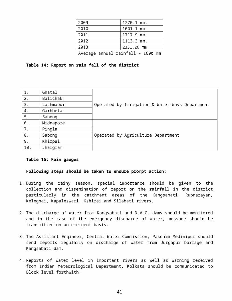
Kangsabati Dam. If the release of water from Kangsabati Dam can be regulated in a proper way, intensity of flood can be reduced. The average rain fall of the district since 1994
Year Total rainfall1994 1620.24 mm1995 1584.28 mm1996 1319.02 mm1997 1624.24 mm1998 1137.24 mm1999 1655.24 mm2000 1354.76 mm2001 1426.52 mm2002 1549.2 mm2003 1553.14 mm2004 1375.04 mm.2005 1686.8 mm.2006 1298.8 mm.2007 2106.0 mm.2008 1780.44 mm.2009 1270.1 mm.2010 1001.1 mm.2011 1717.9 mm.2012 1113.3 mm.2013 2331.26 mm
Average annual rainfall – 1600 mm
Table 14: Report on rain fall of the district
35
1. Ghatal
Operated by Irrigation & Water Ways Department2. Balichak3. Lachmapur4. Garhbeta5. Sabong6. Midnapore
Operated by Agriculture Department7. Pingla8. Sabong9. Khirpai10. Jhargram
Table 15: Rain gauges
Following steps should be taken to ensure prompt action:
1. During the rainy season, special importance should be given to the collection and dissemination of report on the rainfall in the district particularly in the catchment areas of the Kangsabati, Rupnarayan, Keleghai, Kapaleswari, Kshirai and Silabati rivers.
2. The discharge of water from Kangsabati and D.V.C. dams should be monitored and in the case of the emergency discharge of water, message should be transmitted on an emergent basis.
3. The Assistant Engineer, Central Water Commission, Paschim Medinipur should send reports regularly on discharge of water from Durgapur barrage and Kangsabati dam.
4. Reports of water level in important rivers as well as warning received from Indian Meteorological Department, Kolkata should be communicated to Block level forthwith.
5. The Executive Engineers, Midnapore West Division, Midnapore East Division and Kangsabati Canal Projects are requested to send reports on water level at various gauge points on important embankments regularly during monsoon.
6. The Principal Agricultural Officer, Paschim Medinipur should send daily rainfall reports at various rain gauge stations under his jurisdictions.
7. Early receipt of the information of the discharge from D.V.C. is important for assessment of flood situation and taking precautionary measures particularly for Ghatal Subdivision.
36

CHAPTER- 4DISASTER MANAGEMENT: FUNCTIONAL STRUCTURE IN THE DISTRICT
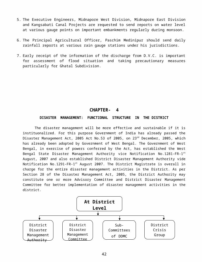
The disaster management will be more effective and sustainable if it is instituonalized. For this purpose Government of India has already passed the Disaster Management Act, 2005 Act No.53 of 2005, on 23rd December, 2005, which has already been adopted by Government of West Bengal. The Government of West Bengal, in exercise of powers conferred by the Act, has established the West Bengal State Disaster Management Authority vice Notification No.1281-FR-1st August, 2007 and also established District Disaster Management Authority vide Notification No.1291-FR-1st August 2007. The District Magistrate is overall in charge for the entire disaster management activities in the District. As per Section 28 of the Disaster Management Act, 2005, the District Authority may constitute one or more Advisory Committee and District Disaster Management Committee for better implementation of disaster management activities in the district.
4.1 District Disaster management authority
As per Notification No.1291-FR-1st August, 2007 the District Disaster Management authority consisting Chairperson and six members having Head Quarter at District level has been established. It acts as the district planning, coordinating and implementing body for disaster management and take all measures for the purpose of Disaster Management in accordance with the guidelines laid down by the National and the state Authority.
37
At District Level
District Disaster Management
Authority
District Disaster Management
Committee
Sub-Committees of DDMC
District Crisis Group

District Disaster Management Authority (D.D.M.A.)
1. Collector of the District: CHAIRPERSON2. Sabhadhipati of Zillah Parishad: CO-CHAIRPERSON3. Superintendent of Police: Ex-officio Member 4. Chief Medical Officer of Health: Ex-officio Member5. Not exceeding two (2) other District Level Officers to be appointed by the State Govt.
At the District Level, there should be a District Disaster Management committee, at Block Level, there should be a Block Disaster Management Committee and at village level there should be village level there should be village Disaster Management Committee.
Apart from these disaster management committees, at each level there should be a disaster management plan as per vulnerability to disaster of that particular area along with the various task forces like search and rescue, first aid, early warning system, food management, shelter management, dead body disposal force etc.
At the Village Level, Panchayat are the decision making bodies of all development activities in the villages. Therefore, every Panchayat should have a Village level Disaster Management Committee (VDMC) headed by the Pradhan which is responsible for carrying out activities from Planning to Execution in Disaster Management. There should be a separate village disaster management plan for every village as per vulnerability to disaster of the particular village. The plan encompasses prevention, mitigation and preparedness measures. The VDMC chaired by Pradhan includes, ward members, gramsevak, local Government functionaries including doctors/paramedics of primary health centers located in the village, primary school teachers etc. also a search and rescue team as well as first aid team have to be set up and trained at every village. The Disaster Management Teams at the village level will consist of members of youth organizations like Nehru Yuva Kendra and other non-governmental organizations as well as able bodied volunteers from the village. The teams are to be provided basic training in evacuation, search and rescue, first aid trauma counseling etc.
At Sansad Level, the village where Sansad members are members of VDMC they should get involved in taking all sort of major decisions related to Disaster Management, whether it is the Disaster Management Preparedness Plan or preparation to respond during the disaster. They are important identities in the village representing the community. The Disaster Management Committee will review the disaster management plan at least once in a year. It would also generated awareness among the people in the village about do’s and do not do’s for specific hazards depending on the vulnerability of the village.
At Block Level, every Block in the district should have a Block Disaster Management Committee headed by Chairperson Panchayat Samiti and all line departments at block level are its members.
At District Level, the disaster management committee should be constituted under the chairmanship and co-chairpersonship of Deputy Commissioner and Chairperson respectively.
The District Disaster Management Authority shall act as the District Planning; coordinating and implementing body for disaster management and take all measures for the purpose of disaster management in the district in accordance with the guidelines laid down by the National Authority and the State Authority.

4.1.1 The role of District Disaster Management Authority
I. Prepare a disaster management plan including district response plan for the district;II. Coordinate and monitor the implementation of the National Policy, West Bengal State Disaster
Management Policy, national Disaster Management plan, West Bengal Disaster Management Plan and District Disaster Management Plan;
III. Ensure that the areas in the district vulnerable to disasters are identified and measures for the prevention of disasters and the mitigation of its effects are undertaken by the departments of the Government at the district level as well as by the local authorities.
IV. Ensure that the guidelines for prevention of disasters, mitigation of its effects, preparedness and response measures as laid down by the National Authority and the West Bengal State Authority are followed by all departments of the Government at the district level and the local authorities in the district;
V. Give directions to different authorities at the district level and local authorities to take such other measures for the prevention or mitigation of disasters as may be necessary.
VI. Lay down guidelines for prevention of disaster management plans by the departments of the Government at the districts level and local authorities in the district;
VII. Monitor the implementation of disaster management plans prepared by the departments of the Government at the district level.
VIII. Lay down guidelines to be followed by the Departments of the West Bengal Government at the district level for purpose of integration of measures for prevention of disasters and mitigation in their developmental plans and projects and provide necessary technical assistance therefore;
IX. Monitor the implementation of measures referred to in Item N.X. Review the state capabilities for responding to any disaster or threatening disaster situation in the district
and give directions to the relevant departments or authorities at the district level for their up-gradation as may be necessary.
XI. Review the preparation measures and give directions to the concerned departments at the district level or other concerned authorities where necessary for bringing the preparedness measures to the levels required for responding effectively to any disaster or threatening disaster situation;
XII. Organize and coordinate specialized training programmes for different levels of officers, employees and voluntary rescue workers in the district;
XIII. Facilitate community training and awareness programmes for prevention of disaster or mitigation with the support local authorities, government and non-governmental organisations;
XIV. Set up, maintain, review and upgrade the mechanism for early warnings and dissemination of proper information to public;
XV. Prepare, review and update district level response plan and guidelines;XVI. Coordinate response to any threatening disaster situation or disaster;
XVII. Ensure that the departments of the Government at the district level and the local authorities prepare their response plans in accordance with the district response plan;
XVIII. Lay down guidelines for, or give direction to, the concerned department of the Government at the district level or any other authorities within the local limits of the district to take measures to respond effectively to any threatening disaster situation or disaster;

XIX. Advise, assist and coordinate the activities of the Departments of the Government at the district level, statutory bodies and other governmental and nongovernmental organisations in the district engaged in the disaster management;
XX. Coordinate with, and give guidelines to, local authorities in the district to ensure that measures for the prevention or mitigation of threatening disaster situation or disaster in the district are carried out promptly and effectively;
XXI. Provide necessary technical assistance or give advice to the local authorities in the district for carrying out their functions;
XXII. Review development plans prepared by the Departments of the Government at the district level, statutory authorities or local authorities with a view to make necessary provisions therein for prevention of disaster or mitigation.
XXIII. Examine the construction in any area in the district and, if it is of the opinion that the standards for the prevention of disaster or mitigation laid down for such construction is not being or has not been followed, may direct the concerned authority to take such action as may be necessary to secure compliance of such standards;
XXIV. Identity buildings and places which could, in the event of any threatening disaster situation or disaster, be used as relief centres or camps and make arrangements for water supply and sanitation in such buildings or places;
XXV. Establish stockpiles of relief and rescue materials or ensure preparedness to make such materials available at a short notice;
XXVI. Provide information to the State Authority relative to different aspects of disaster management;XXVII. Encourage the involvement of non-governmental organisations and voluntary social-welfare institutions
working at the grassroots level in the district for disaster management;XXVIII. Ensure communication systems are in order, and disaster management drills are carried out periodically;
XXIX. Perform such other functions as the West Bengal Government or the West Bengal Disaster Management authority may assign to it or it deems necessary for disaster management in the district.
4.2 Disaster Management Committee (DDMC)
Disaster is caused by various types of calamities and each calamity creates its own problems. To handle and solve all such problems, a well knit organisation and trained man-power is required and team or high level officials required for managing the disaster. To minimize the effects of disaster, proper planning and coordination at the level of the Chairperson of the District Disaster Management Authority is must. Therefore, District Disaster Management Committee (DDMC) under the chairmanship of Deputy Commissioner should be formed. The Committee should meets once in a year under the chairmanship of the Deputy Commissioner to review the overall mitigation and preparedness activities in respect of Disaster management in the district. The Committee should consist the following functionaries-
DISTRICT DISASTER MANAGEMENT COMMITTEE, PASCHIM MEDINIPUR
1. The Sabhadhipati, Zilla Parishad, Paschim Medinipur Chairman.2. The District Magistrate, Paschim Medinipur Vice-chairman3. The Additional District Magistrate (Gen), Paschim Medinipur Member Secretary4. The Superintendent of Police, Paschim Medinipur Member5. The Karmadhakshya, Tran Sthayee Samity, Zilla Parishad, Paschim Medinipur. Member
6. The Chief Medical Officer of Health., Paschim Medinipur Member7. The Executive Engineer, P.W.D., Paschim Medinipur Member8. The Executive Engineer, P.H.E., Paschim Medinipur Member9. The Executive Engineer, I.&W.Deptt., Paschim Medinipur Member10. The Principal Agriculture Officer, Paschim Medinipur Member11. The District Animal Resources Dev. Officer, Paschim Medinipur Member12. The District Disaster Management Officer, Paschim Medinipur Member13. The District Inspector of Schools (Primary), Paschim Medinipur Member14. The District Inspector of Schools (Secondary), Paschim Medinipur Member15. Hon’ble Members of Legislative Assembly
(All MLAs of Paschim Medinipur District)Member
In the similar manner disaster management committees have been constituted at the sub-division lvel and block level to coordinate and supervise the disaster management operations.
Sub Divisional Disaster Management Committee
1. Sub divisional Officer : Chairperson2. Sub Divisional Disaster Management Officer : Convener /Member3. Subdivisional Controller of Food & Suppliers4. Subdivisional Police Officer5. Subdivisional Officer (Irrigation)6. Secretary, Red Cross Society7. Subdivisional Agriculture Officer8. Assistant Engineer ( PWD )9. Assistant Engineer (PWD Roads)10. Assistant Chief Medical Officer of Health11. O/C Civil Defence12. Members of Legislative Assembly13. Chairperson of all municipality14. All B.D.Os & All Sabhapaties
Block level Disaster Management Committee
1. Sabhapati, Panchayat Samity : Chairperson2. Block Development Officer : Secretary3. Block Disaster Management Officer4. Agriculture Development Officer5. Block Medical Officer of Health
6. O/C of Police Station7. Karmadhakshya of Tran Styaee Samity8. All Pradhans9. All M.L.A in the block area10. All block level officers of line departments
CHAPTER-5
REHABILITATION AND RECONSTRUCTION PLAN
Rehabilitation and reconstruction comes under recovery phase immediately after relief and rescue operation of the disaster. This post disaster phase continues until the life of the affected people comes to normal. This phase mainly covers damage assessment, disposal of debris, disbursement of assistance for houses, formulation of assistance packages, monitoring and review, cases of non-starters, rejected cases, non-occupancy of houses, relocation, town planning and development plans, awareness and capacity building, housing insurance, grievance redressal and social rehabilitation etc.
5.1 Post Disaster Reconstruction and Rehabilitation
Post disaster reconstruction and rehabilitation should pay attention to the following activities for speedy recovery in disaster hit areas. The contribution of both government as well as affected people is significant to deal with all the issues properly.
Damage assessmentDisposal of debrisDisbursement of assistance for housesFormulation of assistance packagesMonitoring and reviewCases of non-starters, rejected cases, non-occupancy of housesRelocationTown planning and development plansReconstruction as Housing Replacement PolicyAwareness and capacity buildingHousing insuranceGrievance redressal
5.2 Administrative Relief
The district is the primary level with requisite resources to respond to any natural calamity, through the issue of essential commodities, group assistance to the affected people, damage assessment and administrating appropriate rehabilitation and restoration measures.
The district level relief committee consisting of official and non-official members including the local legislators and the members of parliament review the relief measures. Paschim Medinipur district is sub-divided into 4 sub-divisions i.e. Medinipur Sadar, Kharagpur, Jhargram and Ghatal. The head of sub-division is called the Sub-Divisional Officer (SDO) while development officer (BDO). When a disaster is apprehended, the entire machinery of the district, including the officers of technical and other departments, swings into action maintains almost continuous contact with each village in the disaster threatened area.
5.3 Reconstruction of House Damaged / Destroyed
House should be reconstructed in the disaster hit areas according to the following instructions:
Owner Driven Reconstruction Public Private Partnership Programme (PPPP) Under the PPPP the house are reconstructed by the NGOs for the beneficiaries to be registered in the
joint names of the husband and wife. All the houses should be insured. Owner Driven Reconstruction Financial, technical and material assistance provided by the Government.
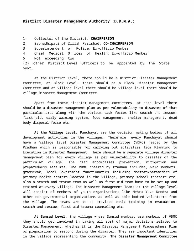
The designs for seismic reconstruction of houses provided by the Government. The material assistance provided through material banks at subsidized rates. Design of 20 model houses provided to the public to choose from with an option to have one’s own
design.
5.4 Military Assistance
If the district administration feels that the situation is beyond its control then immediate military assistance could be sought for carrying out the relief operation.
5.5 Medical Care
Specialized Medical Care may be required to help the affected population preventive medicine may have to be taken to prevent outbreak of diseases.
5.6 Epidemics
In the relief camps set up for the affected population, there is a likelihood of epidemics from a number of sources. The strategy should be to subdue such sources and immunize the population against them. The public health centres, health departments can practice vaccination drives, public awareness to drink boiled water, use chlorine tablets to purify the water sources.
5.7 Crops Disposal
Disposal of dead bodies is to be carried out as a part of the operation to prevent outbreak of epidemics. Minimum official requirements should be maintained as it is a very sensitive issue. The following points may be considered by the concerned authorities at the time of corpse disposal:-
1. Mass photographs of corpses,2. Consent of the relatives or hand over them3. Make panchnama of concerned localities.
5.8 Salvage
A major effort is needed to salvage destroyed structure and property. Essential services like communications, roads, bridges, electricity would have to be repaired and restored for normalization of activities.
5.9 Outside Assistance
During disaster situation, considerable relief flows in from outside, thus there is an immediate need to co-ordinate the relief flows so that the maximum coverage is achieved and there is no duplication of work in the same area.
5.10 Special Relief
Along with compensation packages, essential items may have to be distributed to the affected population to provide for temporary sustenance.
5.11 Information
Information flow and review is essential part of the relief exercise. Constant monitoring is required to assess the extent of damage, which forms the basis of further relief to the affected areas.
5.12 Social Rehabilitation
Disabled persons Artificial limbs fitted to affected persons. Modern wheelchairs, supportive devices provided.
Children Orphaned children are fostered. Day centers set up Orphanages established. Child help lines established.
Paraplegics Pension scheme introduced for paraplegics. Physiotherapy under continuous supervision of doctors.
Old Persons Aged persons given pensions. Old Age Homes established.
Women Pension sanctioned.
CHAPTER-6
SOME VALUABLE INFORMATION & DISASTER SPECIFIC ACTION PLAN/ STANDARD OPERATINGPROCEDURE FOR PASCHIM MEDINIPUR DISTRICT ADMINISTRATION
6.1 FLOOD PRONE AREAS
The topography of the district is such that eastern part of the district is affected more than the western part of the district. The list of affected blocks and municipalities is as follows:
Name of theSub-Division
Vulnerable Blocks / Municipality
Partly affected Blocks / Municipality
Water logging Blocks / Municipality
Ghatal
1. Ghatal 1. Chandrakona-I 1. Chandrakona-II
2. Daspur-I 2. Kharar Municipality 2. Khirpai Municipality
3. Daspur-II 3.Ramjibanpur Municipality 3.Chandrakona Municipality
4. Chandrakona-I 4. Ghatal Municipality
5. Chandrakona-II
Kharagpur
6. Sabong 4. Dantan-I 5. Kharagpur-I
7. Pingla 5. Dantan-II 6. Kharagpur-II
8. Narayangarh 6. Debra 7. Keshiary
7. Mohanpur
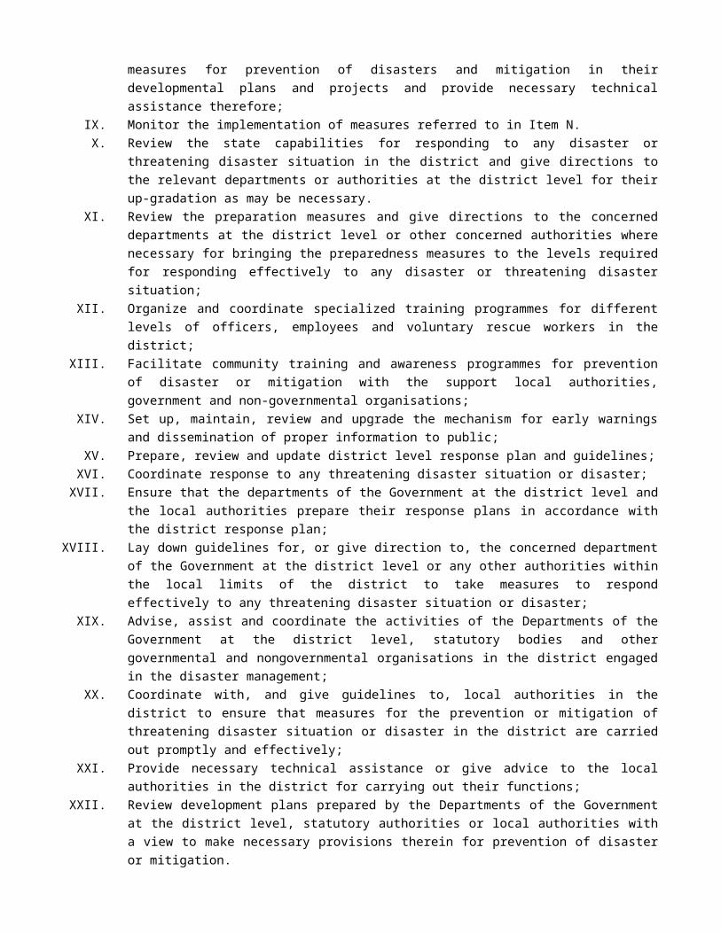
Medinipur Sadar
9. Medinipur Sadar 8. Garhbeta-I 8.Midnapur Municipality
10. Keshpur
11. Garhbeta-II
12. Garhbeta-III
Jhargram
9. Gopiballavpur-I
10. Gopiballavpur-II
11. Nayagram
12. Binpur-I
13. Sankrail
6.2 RESERVE STOCK OF RELIEF MATERIALS
The present stock position of Relief Material and foodgrains as stood on 14.05.2014 at the District Hqrs. is as follows:
Items Available Further RequirementPolysheet 13237 (N.C.) 50,000 Pcs.Saree 5050 Pcs. 10,000 Pcs.Dhuti 5262 Pcs. 10,000 Pcs.Lungi 5411 Pcs. 50,000 Pcs.Children Garments 6499 Pcs. 20,000 Pcs.Blankets 3135 Pcs. 10,000 Pcs.Male Wrapper 3450 Pcs. 10,000 Pcs.Salwar Kamij 5500 Sets. 10,000 Sets.Punjabi & Paijama 4600 Pcs. 10,000 Sets.Spl. GR (Rice) 95.5 MT 500 MTSpl. GR (Wheat) Nil 100 MT
6.3 PRESENT POSITION AND FURTHER REQUIREMENT OF RELIEF CONTINGENCY FUND, CASH G.R AND STARVATION GR FOR THE YEAR 2014-15
Name of item Total amount received
Expenditure incurred /
disbursement / sub-allotment made in this
month
Balance in hand Further requirement
Contingency fund U/H “2245” Rs.5,00,000/- Nil Rs.5,00,000/- Rs.20,00,000/-Contingency FundU/H “2235” Rs.80,000/- Nil Rs.80,000/- Rs.10,00,000/-
Cash G.R. Rs.30,000/- Nil Rs.30,000/- Rs.2,00,000/-

Starvation GR Nil Nil Nil Rs.5,00,000/-
6.4 CAMPING SITES
After receiving the flood warning message people staying in low-lying areas which are inundated in every flood should be alerted first. They should be shifted to safer locations and different camping sites. A list of camping sites is given below:
LIST OF CAMPING SITES
GHATAL SUBDIVISION
Ghatal Block Name of G.P.1. Khasbarh Bundh Irhpala2. Kashbarh Paschim Para Primary School Irhpala3. Joybag Primary School Irhpala4. Joykundu Primary School Irhpala5. Madhabchak Primary School Mansuka – I6. Barkatipur Primary School Mansuka – I7. Sikhpura Circuit Bundh Mansuka – II8. Doulatchak Primary School Mansuka – II9. Fatepur School Mansuka – II10. Banhari Singhpur School Mansuka – II11. Banharisingpur Promodh Dasgupta Vidyapith Mansuka – II12. Seikhpura Circuit Bundh Mansuka – II13. Birsing High School Birsingha14. Jalsara School Birsingha15. Radhanagar School Birsingha16. Haridaspur PrimarySchool Ajabnagar – I17. Irpala Dulepara PrimarySchool Irhpala18. Joynagar Primary School Ajabnagar – I19. Mansuka L.N.HighSchool Mansuka – I20. Tiorapara Primary School Mansuka – I21. Dirghagram Sitalananda Primary School Mansuka – I22. Simulia Cold Storage Mohanpur23. Natuk High School Lachipur School Mohanpur24. Lachipur School Mohanpur25. IslampurPanchayat Office Dewanchak – I26. Barhanabani Dewanchak – I27. S.D.O. Office. Ghatal Municipality28. Nalgeria Primary School Dewanchak – I
29. Maharajpur Adibasi Student Hostel Dewanchak – I
30. Silabari embankment at Joykrishnapur and Denanchak Dewanchak – II31. Gholesai Dewanchak – II32. Simulia School Dewanchak – II33. Balaramgarh High School Ajabanagar – II
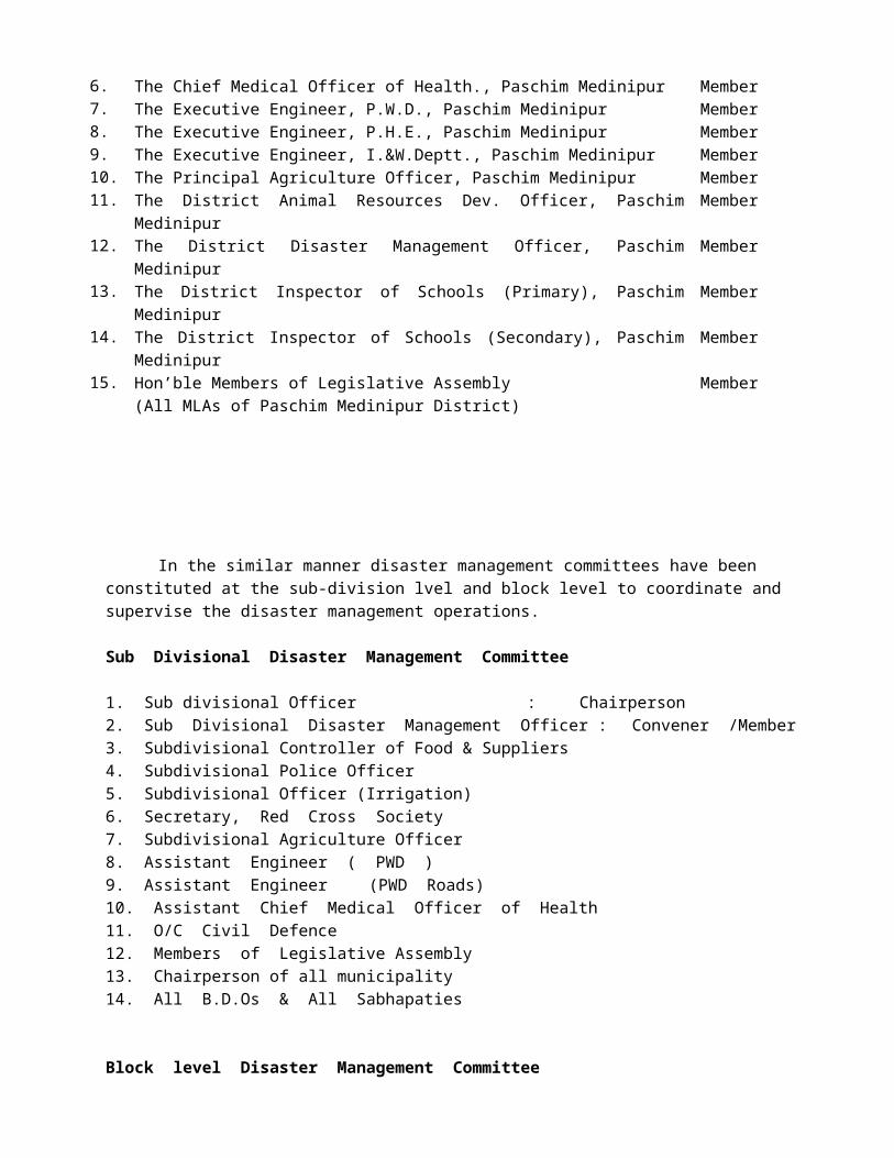
34. Primary School at Joynagar Ghola Ajabnagar –I35. Mandaria Ajabnagar – I36. Radhaballavpur M.C.C.Centre Dewanchak – II37. Kotalpur M.C.C.Centre Dewanchak – II38. Panna High School Ajabnagar – I39. Barda Banipith Ajabnagar - II40. Silarajnagar Primary School Ajabnagar – II41. Gram Panchayat Office at Barada Ajabnagar – II42. Barda Bisalakshi Mandir Ajabnagar – II43. Sitalpur Primary School Ajabnagar – II44. Chetua Circuit embankment (Manoharpur –1 & 2 G.P.) Manoharpur –1 & 245. Vidyasagar High School Ghatal Municipality
46. Basantakumari Girls’ High School Ghatal Municipality
47. Chauli School Ghatal Municipality48. Moti Cinema Ghatal Municipality49. Kharar Municipal Office building Khara Municipality50. Singpur Primary School Ghatal Municipality51. Sukchandpur Primary School Ghatal Municipality
Chandrakona – I Block
1. Chandpur High School ground Manoharpur-II GP2. Khapur Gandha High School ground Manoharpur-I GP3. Field adjacent to Chandrakona-I Block Khirpai Municipality4. Khirpai Football ground near Chowdhury Pukur Khirpai Municiaplity5. Ekbalpur G.P. Office Manoharpur-I GP6. Bharamhajharul High School Manikkundu GP
Chandrakona-II Block
1. Bhagabantapur Gyanadasundari High School Bhagabantapur – Il GP2. Mahespur Jr. High School at Maheshpur Bhagabantapur – Il GP3. Krishnapur Rahamania R. Hish School Bhagabantapur – I GP4. Pa lascha bri Nigamananda High School Basanchora GP5. Ihakra Hish Secondarv School Bandipur – I GP
Daspur-I1. Sarberia-II GP Office Sarberia-II G.P2. Daspur-I Block Office Daspur-I GP3. Rajnagar G.P.Office Rajnagar GP4. Sarberia-I G.P.Office Sarberia-I G.P5. Nimtala Football ground Daspur-I GP6. Danikala High School Nijnarajole GP7. Sagarpur High Sdhool Daspur-II GP8. Nandanpur-II G.P. Office Nandanpur-II G.P.9. Raghunathpur Primary School Daspur-I GP10. Supapursuri Jr. High School NijNarajole GP 11. Nandanpur-I G.P.Office Nandanpur-I G.P
Daspur-II Block
1. Khanjapur Union High School, G.P. Khanjapur / Khanjapur2. Gopalpur Deshbandhu High School, G.P. Khanjapur / Gopalpur3. Kalagaria Daswardar Balika Vidyalay,G.P. Khanjapur / Kalagaria4. Kamalpur Flood Shelter, GP Kamalpur / Kamalpur
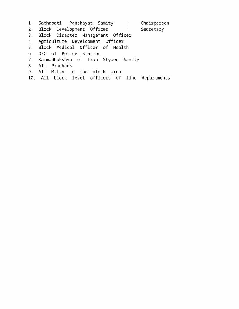
5. Keshabchak Deshgourab High School GP Kamalpur / Keshbchak6. Jotekanuramgarh K.N. Paul High School GP Kamalpur / Jotekanuramgarh7. Dori Ayodhya K.C. Jr. High School GP Ranichak / Dori Ayodhya8. Kumarchak Mahendra High School GP Ranichak / Kumarchak9. Ranichak Deshpran High School GP Ranichak / Ranichak10. Bhuta DAV High School GP Sahachak / Bhuta11. Baruna Satsangha Jr. High School GP Sahachak / Baruna12. Ghanashyambati Satsangha Madrasa GP Sahachak / Ghanasyambati13. Chaipat Flood Shelter GP Chaipat / Chaipat14. Chaipat High School GP Chaipat / Chaipati15. Chaipat Girls’ High School GP Chaipat / Chaipat16. Kaijuri Vidyasagar High School GP Benai / Kaijuri17. Arit Vivekananda Vidya Mandir GP Benai / Arit18. Kheput High School GP Kheput / Uttarbarh19. Kheput Girls’ High School GP Kheput / Uttarbarh20. Nischintapur Flood Shelter GP Nischintapur / Nischintapur21. Panchgachia Gostobihari H.S. GP Nischintapur / Panchgachia22. Chaksultan Flood Shelter GP Goshathi / Chaksultan23. Sonakhali High School GP Goshati / Sonakhali24. Sonakhali Girls’ H.S. GP Goshati / Sonakhali25. Jotebhagaban H.S. GP Goshati / Jotebhagaban26. Palaspai Bhagabati Balika Vidyalay GP Palaapai / Palapai27. Bhagabnchak Ptiram Siksha Niketan GP Palaspai / Bhagabanpur28. Goura Sonamui KG H.S.& KBA G.HS GP Goura / Sonamui 29. Nabin Manua High School GP Goura / Nabin Manua30. Rampur Manua KKIRR High School GP Goura / Rampur31. Khukurdah ICMM High School GP Khukurdaha / Khukurdaha32. Kashinathpur J.K. High School GP Khukurdaha / Kashinathpur33. Lakshyakundu R.N. Routh H.S. GP Khukurdaha / Lakshyakundu34. Joteghanashyam Nilmani H.S. GP Joteghanashyam / Joteghanashyam35. Gomakata GR High School GP Joteghanasyam / Gomakata36. Maguria Flood Shelter GP Dudhkomra / Maguria37. Sreebora High School GP Dudhkomra / Sreebora38. Dudhkomra High School GP Dudhkomra / Dudhkomra39. Kultikri K. H.S. GP Dudhkomra / Kultikri
KHARAGPUR SUBDIVISION
Sabong Block Name of G.P1. Bhua Pry. School, Nowgan2. Chaulkuri Flood Rescue Centre, Chaulkuri3. Amarbarh Pry. School, Narayanbarh4. Harirhat Pry. School, Sabang5. Tilantapara High School, Balpai6. G.P. Office, Bhemua, Bhemua7. Mohar High School, Mohar8. Bural G.P. Office, Bural9. Chandkuri High School, Danrra10.Lokpith High School, Bishnupur, Bishnupur11.Mansagram Sivananda Vidyapith, Dasagram12.Laro SKUS at Jhikuria Sarta13.ONGC, Point, Nowgan
Debra Block
1. Harinarayanpur Flood Shelter, Bhabanipur GP / Harinarayanpur

2. Amdanagar Pry. School, Do / Amdanagar3. Patna High School, Do / Patna4. Bhabanipur Pry. School Do / Bhabanipur5. Akaipoush Pry. School Do / Akaipoush6. Kumarsanda Pry. School Do / Kumarsanda7. Bankakul Pry. School Do / Bankakul 8. Asanpur Pry. School Do / Asanpur9. Gopinathpur Pry. School Do / Gopinathpur10. Bahadurpur Pry. School Bharatpur GP / Bhadurpur11. Birsingpur River Buidh Do / Birsingapur12. Talbandhi Pry. School Do / Talbandhi13. Jagannathpur Pry. School Do / Jagannathpur14. Sinua Pry. School Do / Sinua 15. Bhagirathpur Pry. School Do / Bhagirathpur16. Satyaswar Marhtala Insitution Do / Satyapur17. Talbageria Pry. School Do / Talbageria18. Bhainagar Madrasa Do / Bhainagar19. Embankment Bundh of River Do / Saldahari20. Serpur Pry. School Khanamohan GP / Serpur21. Chak Lahana Pry. School Do / Chak Lahana 22. Panchgeria High School Do / Pachgeria23. Nigbarasati Pry. School Do / Nigbarasati24. Trilochanpur High School Malighatai GP / Trilochanpur25. Trilochanpur Club Do / Trilochanpur26. Sijgeria Club Do / Sijgeria27. Bikrampur High School Do / Bikrampur28. Malighati Pry. School Do / Malighati29. Chak Purusattampur Pry. School Do / Chak Purusattampur30. Tangaisri Pry. School Do / Tangaisri 31. Jot-Haro Pry. School Do / Jot Haro32. Gopalnagar Pry. School Do / Gopalnagar33. Golegram Flood Shelter Golegram GP / Golegram34. Golegram H.S. School Do / Do35. Embankment Bundh Do / Do36. Khajuri Pry. School Do / Khajuri37. Karanda Pry. School Do / Karanda38. Jotnarayan Pry. School Do / Jotnarayan39. Mangoli Pry. School Do / Mangoli40. Amarpur Pry. School Do / Amarpur41. Kullya Pry. School Do / Kullya42. Dandeswar Pry. School Do / Dandeswar43. Mainan Pry. School Do / Mainan44. Snarpur Pry. School Do / Snarpur45. Bhuniabasan Pry. School Do / Bhuniabasan46. Dabadari Pry. School Do / Dabadari47. Lowada Girl H.S. School Do / Lowda48. Khasbazar Pry. School Radhamohanpur GP / Khasbazar49. Paikpari Pry. School Do / Paikpari50. Pipurda Pry. School Do / Pipurda51. Sansara Pry. School Do / Sansara52. Sundarpur Pry. School Radhamohanpur GP / Sundarpur
Kharagpur – I
1. Flood Shelter at Amba under Kalaikunda2. Dharendra High School.3. Risha Hut at Risha.4. Bidhan Chandra High School, Gokulpur.
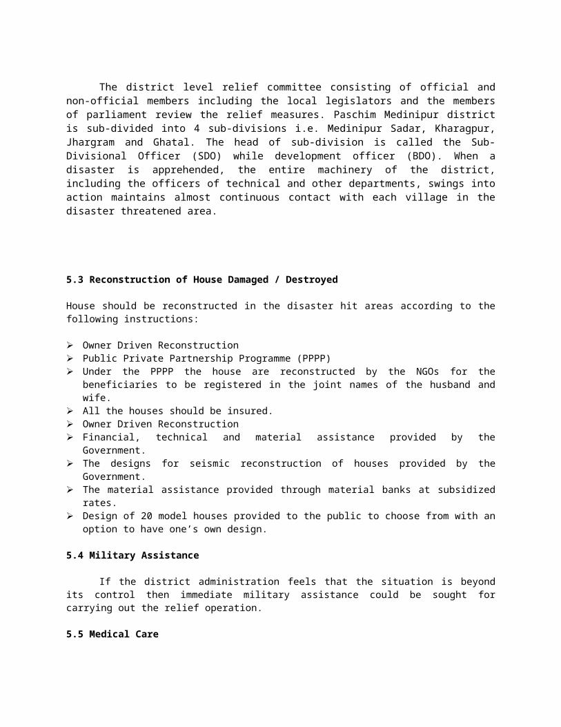
5. Barkola Vivekananda High School.6. Kenduapal Pry. School.7. Jinsahar Vidyasagar Club at Jinsahar.8. Matkatpur Pry. School.9. Charkaboni High School.
Kharagpur- II
1. Krishnanagar Primary School, Lachmapur GP2. Janardanpur High School, Lachmapur GP3. Lachmapur Irrigation Bungalow Lachmapur GP4. Telipukur High School, Kaliara-I GP5. Mukshedpur High School, Kaliara-II GP6. Meudipur High School, Kaliara-III GP7. Khutia Gokulpur V. Vidyapith, Palashya GP8. Routmoni High School, Palashya GP9. Sankoa G.C. High School, Sankoa GP
Pingla
1. Mudamari U.N. Vidyapith, Kusumda GP / Mundamari2. Pingla KK Instutition Jamna GP / Pingla3. Karkai High School Karkai GP /Karkai4. Baragaria High School Karkai GP / Bargaria5. Maligram 2 No. Pry. School Maligram GP / Maligram6. Chhotkhelna High School Maligram GP / Chhotkhelna7. Pinchthubi Pry. School Maligram GP / Pinchthubi8. Khirai SS High School Khirai GP / Khirai9. Jasorajpur S.C. High School Do / Jasorajpur10.Gobardhanpur G.P. Office Gobardhanpur GP / Gobardhanpur11.Saharda High School Do / Saharda12.Upalda High School Do / Pinduri13.Pinduri High School Do / Pinduri14.Laxmipari High School Do / Jalchak15.Barisha High School Do / Jalchak
Dantan-I
1. Praharajpur ICDS, Alikosha GP / Praharajpur2. Mukundapur SSK, Do / Mukundapur3. Rautarapur Pry. & MSK Do / Rautarapur4. Kantapal Pry. School & Antri HS Do / Kantapal5. Borah High School Do / Borah6. Borah HS & Pry School Do / Borah7. Maheshpur Pry School & Rajnagarh Sub-Cnt. Do / Maheshpur8. Rajnagar Pry. School Do / Rajnagar9. Manikora Pry. School Do / Manikora10. Maljamuna High School Do / Maljamuna11. Jetia Pry. School Do / Jetia12. Deuli Pry. School Do / Deuli13. Charda Pry. School Do / Charda14. Uchudia Pry. School & H.S. School Do / Uchudia15. Tararui High School Tararui GP / Tararui16. Kharakhai Pry. School Do / Kharakhai17. Bakurpada Pry. School Do / Bakurpada18. Nilpura Pry. School Do / Nilpura

19. Kotepad High School Do / Kotepad20. Singda Pry School Do / Singda21. Pundra Pry. School Do / Pundra22. Kusturia Pry. School Do / Kusturia23. Khanipur Pry. School Do / Khanipur24. Soripur SSK Do / Soripur25. Dhalhara SSK Monoharpur GP / Dhalhara26. Doasti Pry. School Do / Doasti27. Palasia ICDS Do / Palasia28. Sakhi Do / Sakhi29. Jhari Pry. School Do / Jhari30. Manoharpur High School Do / Manoharpur31. Manoharpur High School Do / Manoharpur32. Kajipara Pry. School Do / Kajipara 33. Maliyara Pry. School Do / Maliyara34. Ganpada SSK Do / Ganpada35. Bejda Pry. School / MSK / Chuch School Do / Bejda36. Sarasanka MSK Salikotha / Sarasanka37. Sarasanka SSK Do / Do38. Dobisha SSK Do / Dobisha39. Kuhura Pry. School Do / Kuhura40. Gajipur Pry. School Do / Gajipur41. Sarasanka SSK Do / Sarasanka42. Asti Pry. School Do / Asti43. Salikotha Pry. School Do / Salikotha44. Menkapur K.R. High School Do / Menkapur45. Dolai High School Angua GP / Dolai46. Angua High School Do / Angua47. Balpatna High School Do / Balpatna48. Lalitapur Pry. School Do / Lalitpur49. Malpara Pry. School Do / Malpara50. Palasia SSK Do / Palasia51. Tukarui Pry. School Do / Tukarui52. Benapura Pry. School Do / Benapura53. Jamua MSK Do / Jamua54. Baidhadra Pry. School Do / Baidhadra55. Sabraping Pry. School Chakismilepur GP / Sabraping56. Satsanda Pry. School Do / Satsanda57. Nimpur Barangi High School Do / Nimpur58. Birdhadrapur High School Do / Birdhadrapur59. Solpatta Pry. School Do / Solpatta 60. Chakismilepur Pry. School Do / Chakismilepur61. Chakismilepur SSK Do / Chakismilepur62. Haripura Pry. School Anikola GP / Haripura63. Dhalbarh SSK Do / Dhalbarh64. Pannaga Pry. School Do / Pannaga65. Bhikubarh SSK Do / Bhikubarh66. Pargana Pry. School Do / Pargana67. Haripura Pry. School Do / Haripura68. Anikola GP Office Do / Anikola69. Bhurungi Pry. School Do / Bhurungi70. Krishnamaityabarh Pry. School Dantan-I GP / Krishanmaityabarh71. Uttar Raibarh Pry. School Do / Uttar Raibarh72. Ektarpur Pry. School Do / Ektarpur73. Rabindra Bhaban Do / Rabindra Bhaban74. Sukumar Sengupta Sishu Uddan Do / Anikola75. Ektapur Pry. School Do / Ektapur76. Belmula Pry. School Dantan-II GP / Belmula
77. Balidangri Pry. School Do / Balidangri78. Naikuibaicha Pry. School Do / Naikuibaicha79. Jhinukpalasia SSK Do / Jhinukpalasia80. Dantan High School Do / Dantan81. Barabaghra Pry. School Do / Barabaghra
Dantan-II1 Sauri Bholanth High School Saurikotbar2 Jahalda High School Porolda3 Sabra Ramkrishna High School Sabra4 Baramohanpur High School Hemchandra (Under Narayangarh Dev. Block)5 Kedar Junior High School Sabra6 Garhharipur High School Haripur7 Turka High School Turka8 Jenkapur High School Jenkapur9 Keshrambha High School Talda
Narayangarh
1. Dhanghori Pry. School, Mokrampur GP2. Shitli Pry. School Do3. Belti Pry. School Do4. Binai Pry. School Do5. Asnaboni Pry. School Do6. Asnaboni Pry. School Do 7. Tala Fulgeria Pry. School Do8. Murakata Pry. School Do9. Kotaigarh High School Garamraj GP10.Basudevpur SSK & Pry. School Do11.Barakalakai High School & Pry. Do12.Majigariya Pry. School Do13.Majigariya Pry. School Do14.Saguna Pry. School Narma GP15.Moninathpur SSK Do16.Madanmohanchak High School Do17.Chakoula Pry. School Do18.Tutranga Pry. School Do19.Chakai Pry. School Do20.Gama High School Do21.Krishi O Krishak Do22.Kalyan Kendra Maguria Do23.Saregeria Pry. School Do24.Narma Pry. School Do25.Narma Batitaki Pry. School Do26.Maligeria Pry. School Do27.Kamiasagar SSK Do28.Narma Pry. School Do29.Madhabchak Pry. School Kunarpur GP30.Saika Patna SSK Do31.Chak Kishore SSK Do32.Jhanjia Nankar SSK Do33.Nayanchak Pry. School Do
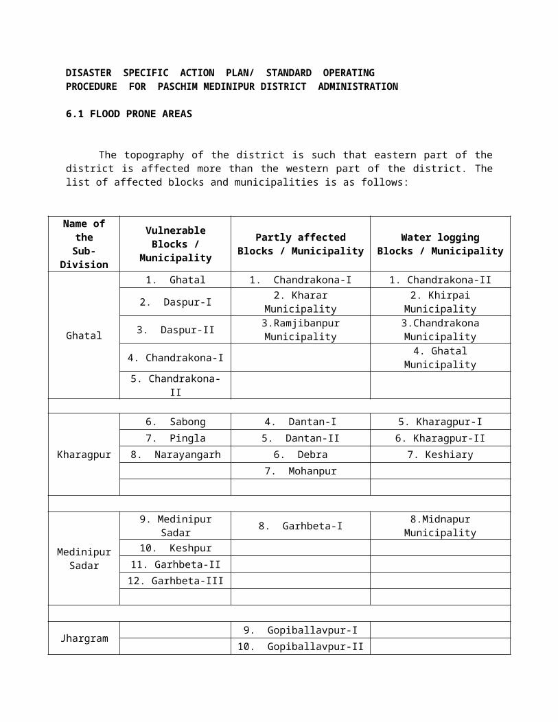
34.Saiboni Pry. School Do35.Sougeria SSK Do36.Kunjigeria Pry. School Do37.Torrah Pry. School Do38.Jagannathpur SSK Do39.Sarisha Pry. School Do40.Chakganka SSK Do41.Kunarpur High School Do42.Parulda Pry. School Do43.Laxmanda SSK Do44.Bardhanu SSK Do45.Ahira Pry. School Do46.Kushda Pry. School Do47.Hetedan SSK Do48.Deulbarh ICDS Do49.Nanda Kishorepur Pry. School Do50.Madhabpur Pry. School Do51.Sonamui Pry. School Do52.Pakurseni GP Pakurseni GP53.Raipur Pry. School Narayangarh GP54.Kanthalia Pry. School Narayangarh GP55.Handlaghat Durgamandir Do56.N.H. Road Do57.Narayangarh PRCL Do58.Bahurupa Pry. School Do59.Navadwip BVP Do60.KDP High School DO61.PRCL High School Do62.Kanthalia Pry. School Do63.Naljhara Pry. School Kashipur GP64.Gokulpur Pry. School Do65.Sarisagaria SSK Rabindranath Do66.Chaknanua Pry. School Do67.Amdiha SSK Haran Ojha Do68.Ranbania SSK Uttam Chakraborty Do69.Kashipur Pry. School Do70.Pravati Balika Bidyapith Belda-I GP71.Sarodamoyee Pry. School Do72.Birendra Pry. School Do73.Kishnapur Pry. School Do74.Bengda Pry. School Do75.Sarisha Pry. School Do76.Kamiachak Pry. School Do77.Patli Pry. School Do78.Banshiarh Pry. School Do79.Bantota Pry. School Do80.Deulti Sudhir High School Belda-II GP81.Belda College Do82.Belda Gangadhar High School Do83.Himangsu SK Pry. School Do
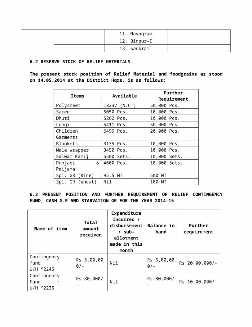
84.Susinda Gouranga Pry. School Do85.Nayna Para Pry. School Do86.Barbelia Pry. School Do87.Nekurseni Vivekananda Vidyabhaban Ranisarai GP88.Khatnagar Pry. School Do89.Sanyapara Pry. School Do90.Nahaparh Dogra Pry. School Do91.Kashipur Pry. School Do92.Kunjapur SSK & Gangutia Pry. School Mannya GP93.Chengutia Pry. School Do94.Trikalpur Pry. School Do95.Mannya High School Do96.Bentkuria SSK Do97.Keshabchak Pry. School Do98.Amda Pry. School Do99.Ramnagar Pry. School Do100. Nima Pry. School Do101. Chakmahima Pry. School Do102. Chandipur SSK Do103. Budhmangli SSK Do104. Baramohanpur High School Tutranga GP105. Baramohanpur High School Do106. Amuria Pry. School Do107. Asda MSK Do108. Asanda High School Do109. Nayabasan Pry. School Do110. Madhabpur Pry. School Do111. Salimchak Pry. School Do112. Tutranga High School Do113. Taruna Pry. School Do114. Rama Pry. School Do115. Uttar Mulkuria Pry. School Do116. GP Office Meeting Hall Do117. Khalina High School Bakhrabad GP118. Bardai High School Do119. Bakhrabad High School Do120. Thakuchak Birborpur Do121. Shyanpara Do122. Gopinathpur High School Khurshi GP123. Kankurgera SSK Do124. Porakella Pry. School Do125. Hatikhoda SSK Do126. Balichaturi Pry School Do127. Gobindapur SSK Do128. Paharpur Pry. School Do129. Fulveri SSK Do130. Khurshi Pry. School Do131. Chakmukunda High School Do132. Pratappur SSK Do133. Tapsia SSK Do

134. Takla Pry School Do135. Gomua SSK Do136. Hatmukunda SSK Do137. Duria MSK Do138. Duria Sibananda Pry. School Do139. Sisra Pry. School Do140. Manikora Pry. School Do141. Chenga Pry. School Do142. Pasanda Pukur Parh Kushbasan GP 143. Deulbarh Pry. School Do144. Sangonua SSK & Gonua Pry. School Do145. Gonua (E) Pry. School Do146. Adampur Pry. School Do147. Adampur Pry. School Do148. Keshipur Pry. School Do149. Rajpur Pry. School Do150. Kushbasan High School Do151. Lakshmanda SSK Do152. Parulda (S) Pry. School Do153. Gaita High School Do154. Janadanpur SSK Do155. Ambidangar SSK Hemchandra GP156. Gurdala Pry. School Do157. Ganguria Sitala Mandir Do158. Kashia Pry. School Do159. Gahira Pry. School Do160. Sasinda High School Do161. Raghunathpur Pry. School Do162. Nidhichak Pry. School Do163. Bairampur Pry. School Do164. Radhanagar Pry. School Do165. Kiajhuri Pry. School Do166. Paikhola ICDS Do167. Kulseni SSK Do
Mohanpur
1. Sautia High School, Sautia GP / Sautia2. Arnuya High School, Sautia GP / Arnuya3. Samsara Patpara High School, Sautia GP / Samsara4. Akpura PL Sikshaniketan High School, Sautia GP / Akpura5. Bangihatia MSK Sautia GP / Bangihatia6. Siyalsai High School Siyalsai GP / Siyalsai7. Mathuribar Antla MSK Siyalsai GP / Mathuribar 8. Shyambag Primary School Siyalsai GP / Shyambag9. Siyalsai Primary School Siyalsai GP / Siyalsai10. Adalpur SSK Siyalsai GP / Adalpur11. Dhourjamua Primary School Siyalsai GP / Dhourjamua12. Mohanpur High School Mohanpur GP / Mohanpur13. Baita High School Mohanpur GP / Baita14. Mohanpur Usha Sasi Balika Vidyalaya Do / Mohanpur15. Community Hall (Bodhan) Do / Mohanpur

16. Rajnagar MSK Do / Rajnagar17. Bagda SKUS Do / Rajnagar18. Nilda High School Nilda GP / Nilda 19. Gomunda High School Do / Gomunda20. Dhuipara High School Do / Dhuipara21. Dobaria Pry. School Do / Dobaipara22. Borai High School Do / Borai23. Kumarda MSK Do / Kumarda24. Tanua High School Tanua GP / Tanua25. Begunia High School Do / begonia26. Amarda MSK Do / Amarda27. Begunia Pry. School Do / Begunia28. Dantunia Pry. School Do / Dantunia
Keshiary 1. Galighata Pry. School, Ghritagaram GP2. Ghritagram Pry. School, Do3. Khajra SCM High School, Khajra GP4. Kulasent Pry. School, Santrapur GP5. Pathandiha Pry. School, Kusumpur GP6. Vimruliya Pry. School, Do7. Benadiha GP Office, Baghasty GP8. Indra Pabnia Pry. School, Do9. Kulbani High School, Do10.Kulbani Pry. School, Do11.Jhareswarpur AWC, Do12.Baghasty High School, Do13.Baghasty High School, Do14.Nachipur High School, Nachipur GP15.Sukharole Pry. School Do16.Gaini SSK Do17.Joykrishnapur High School Do18.Rajanikanta Pry. School Kehsiary GP19.Pirot Pry. School Do20.Sukhendubi Pry School Do21.Kalabani Pry. School Lalua GP
JHARGRAM SUBDIVISION
Jhargram
1. Sevayatan High School, GP Radhanagar2. Sevayatan Girls’ School, GP Radhanagar3. Dakshinsole Pry. School, GP Radhanagar4. Community Hall, Badhora, Baida Pry. School, GP Bandhgora5. Amjhuki Pry. School, GP Bandhgora6. Ranchandrapur Pry. School, GP Sapdhara7. Nedabahara GP Office, GP Nedabahara8. Nedabahara Pry. School, GP Nedabahara9. Salboni GP Office, GP Salboni10. All Pry. School, GP Salboni11. Joypur Pry. School, GP Manikpara12. Muraboni MSK, GP Manikpara13. Indardanga Pry. School, GP Sardiha14. Garmohan Pry. School, GP Sardiha
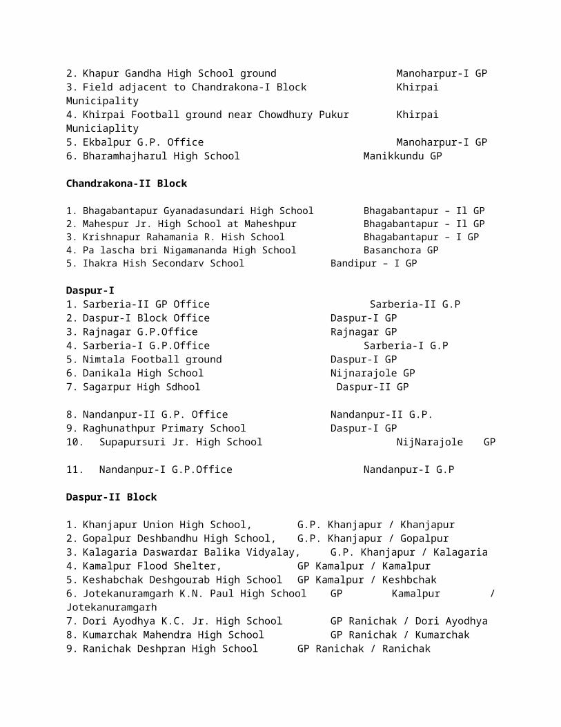
15. Kismat Balijuri Pry. School, GP Sardiha16. Khalsiuli High School, GP Chubka17. Chowkichati Pry. School, GP Dudhkundi18. Bardanga Jr. High School, GP Dudhkundi19. Sagarbhanga Pry. School, GP Dudhkundi20. Naharia Pry. School, GP Lodhasuli.21. Aguiboni Pry. School, GP Aguiboni22. Ektal High School, GP Aguiboni23. Baitagobindapur Pry. School, GP Patasimul24. Patasimul SC High School, GP Patasimul25. Asti Pry. School, GP Chandri.26. Salguria Pry. School, GP Chandri27. Aushpal Pry. School, GP Chandri28. Prantik Service Station, GP Chandri29. Tuna Carage, GP Chandri
Binpur-I
1. Baita Srigopal Jr. High School, JL-901 13. Dalarampur Primary School,JL-4682. Baita Primary School, JL-901 14. Papatpur Primary School,JL-4783. Barkola Jr. High School,JL-817 15. Nachipur High School,JL-5714. Gohomindanga High School,JL-879 16. Lalghata Primary School,JL-5675. Bamalsini Primary School,JL-808 17. Khosaguri Primary School,JL-7076. Chamtiarah Primary School,JL-803 18. Tilaboni High School,JL-4637. Damujana Primary School,JL-811 19. Muraboni High School,-7238. Lalgarh R.K.Vidyapith,JL-790 20. Ranarani High School,JL-7359. Lalgarh Saradamoni Jr.High, 21. Fullerha Primary School,JL-909 School & Lalgarh Pry.School JL-790 22. Balarampur Primary School,98610. Birkanath Pry. School,JL-771 23. Dahijuri Mahatma Vidyapith,97011. Kanthapahari Vidyapith, JL-591 24. Belatikri Primary School,76212. Sijua Primary School,JL-572
Sankrail 1. Khamarmahuli Pry. School Dhanghori Gram Panchayat2. Kubda High School Dhanghori Gram Panchayat3. Ragra High School Ragra Gram Panchayat 4. Telkand Pry. School Ragra Gram Panchayat5. Andhari High School Andhari Gram Panchayat 6. Andhari Pry. School Andhari Gram Panchayat7. Baharadari Pry. School Andhari Gram Panchayat8. Rohini High School Rohini Gram Panchayat 9. Chhorda High School Khudmorai Gram Panchayat 10.Gobindapur Pry. School Sankrail Gram Panchayat 11.Rampura Pry. School Laudaha Gram Panchayat12.Laudaha High School Laudaha Gram Panchayat
Nayagram
1. Kharikamathani Football ground, JL-148 GP- Kharikamathani2. Nayagram Kachari Maidan, JL-143 GP-Nayagram3. Jamirapal Hospital ground, JL-235 GP-Jamirapal4. Patina Jr. High School, JL-07 GP-Patina5. Kalampukuria Jr. High School ground, JL-75 GP- Malam6. Tapsia Jr. High School, JL-176 This School is not situated under Nayagram Dev. Block
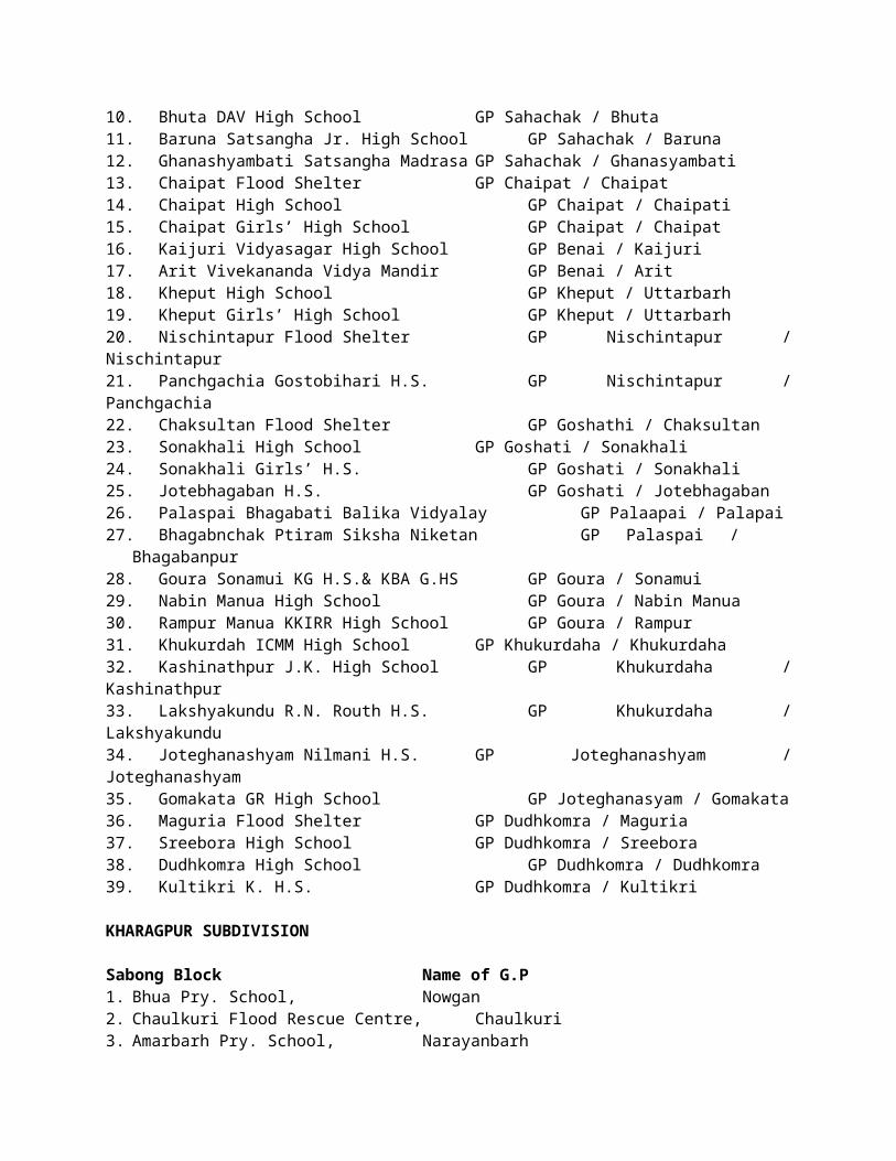
Gopiballavpur-I1. Babudumro High School, Satma GP / Badudumro2. Noagaon Community Hall, Satma GP / Noagon3. Bangsidharpur Pry. School, Satma GP / Bangsidharpur4. Madansole High School, Amarda GP / Madansole5. Madansole Pry. School, Amarda GP / Madansole6. Janaghati Pry. School, Amarda GP / Janaghati7. Manichberia Pry. School, Amarda GP / Manichberia8. Athangi Pry. School, Amarda GP / Athangi9. Morko Pry. School, Sasra GP / Morko10. Sasra Pry. School, Sasra GP / Sasra11. Tikayatpur Pry. School, Sasra GP / Tikayatpur12. Panchkahania High School, Sasra GP / Panchkahania 13. Betkala Pry. School, Sasra GP / Betkala14. Shyamsundar Pry. School, Saria GP / Shyamsundar15. Sumitrapur Community Hall, Saria GP / Sumitrapur16. Ashui High School, Saria GP / Ashui17. Kaima Pry. School, Saria GP / Kaima18. Nayabasan J.K. Vidyapith Gopiballavpur GP / Nayabasan19. Sijua Pry. School, Gopiballavpur GP / Sijua 20. Kapasia Pry. School, Gopiballavpur GP / Kapasia21. Subarnarekha College, Gopiballavpur GP / Subarnarekha22. Parulia Pry. School, Gopiballavpur GP / Parulia23. Topgeria Pry. School, Alampur GP / Topgeria24. Tentulia Pry. School, Alampur GP / Tentulia25. Gopalpur Pry. School Alampur GP / Gopalpur26. Bankra SS Vidyapith Alampur GP / Bankra 27. Nimdiha Pry. School Alampur GP / Nimdiha28. Bhola Pry. School Kendugari GP / Bhola29. B.A.B. MSK Kendugari GP / B.A.B30. Mahipal Pry. School Kendugari GP / Mahipal
Gopiballavpur-II1. Chorchita High School, Chorchita GP / Chorchita2. Kolesole Pry. School, Chorchita GP / Kolesole.3. Askola Pry. School, Nota GP / Asksola4. Dhadangri High School, Nota GP / Asksola5. Gohalura MSK Tapsia GP / Gohalura6. Sardiha Pry. School Tapsia GP / Sardiha7. Paikambi High School Tapsia GP / Paikambi 8. Malincha High School & Pry. School Kuliana GP / Malincha 9. Gundurghora Pry. School Kuliana GP / Gundurghora10. Rantua High School Kuliana GP / Rantua 11. Beliaberah High School Kuliana GP / Beliaberah12. Balipal Pry. School Kharbandi GP / Balipal13. Ramchandrapur High School Kharbandi GP / Ramchandrapur14. Amdapal Pry. School Kharbandi GP / Amdapal 15. Panchrkuhi Pry. School Kharbandi GP / Panchrkuhi16. Petbindhi DKM High School Petbindhi GP / Petbidhi17. Dangria Pry. School Petbindhi GP / Dangria18. Baghuasole High School Petbindhi GP / Baghuasole19. Mahapal High School Petbindhi GP / Mahapal
MIDNAPORE SADAR SUBDIVISION
Midnapore Sadar 1. Mahatapnagar High School Pathra GP

2. Telya High School Pathra GP3. Harishpur D.P. High School Panchkhuri-II GP4. Panchkuri H.S. School Panchkhuri-I GP5. Chunadanga H.S. School Panchkhuri-II GP6. Banpura G.P. Office Banpura GP
Garbeta-I1. Sandhipur S.S. High School Sandhipur G.P.2. Banerjeedanga High School Amlagora G.P.3. Sanmura V.S.S. High School Baramura G.P.4. Ramkrishna Mission Jr. High School Amlagora G.P.5. Mohanpur Primary School Kadrauttarbil G.P.6. Nohari High School Agra G.P.7. Dhadika Jr. High School Dhadika G.P.8. Monglapota High School Kharkushma G.P.9. Garbeta High School Garhbeta G.P.10. Fulmonipur Moulara Sarat Amkopa G.P.
Garbeta-II1. Goaltore High School Goaltore GP / Pingboni GP2. Amlasuli I.N. High School Amlasuli GP3. Gopalnagar Pry. School Piasala GP4. Suniakone Pry. School Do5. Hoomgarh Girls’ High School Do6. Lalbahadur Sastri High School Jogardanga GP7. Dhobasole MSK Do
Keshpur 1. Shyam Chandrapur Jr. High School,GP-1 12. Golar Pry. & Jr. High School, GP-42. Amura Jr. & Primary School,GP-4 13. Mughbasan High School, GP-53. Sahaspur High School, GP-6 14. Pipurda Jr.& Pry. School, GP-84. Anandapur High School,GP-9 15. Mahisda H.S. & Pry. School, GP-105. Keshpur H.S. & Pry. School, GP-10 16. Angua High School,Bilashbarh,GP-146. Chhutargeria Madrasa, GP-12 17. Eluni Primary School,GP-37. Gopinathbari Primary School,GP-11 18. Kalagram H.S. & Pry. School,GP-118. Parulia Narayanchak Pry.School,GP-13 19. Dhalhara Pry. & H. School, GP-139. Biswanathpur High School,GP-15 20. Keshtikri Primary School, GP-410.Pakuria Multi Pry & High School, GP-15 21. Mogra Primary School, GP-1211.Kanchantala H.School,GP-12 22. Andhichak Jr. High School,GP-123. Bajuara Pry. School, GP-5 24. Panchami Pry. School, GP-825. Khasbarh H.S., GP-14
6.5 LIST OF SUITABLE PLACES ALONG WITH COORDINATES FOR LANDING OF HELICOPTER
Sl. No. Name of sub-division
Name of Block No. Name of the Site Latitude & Longitude of the
place1.
Med
inip
ur S
adar
Medinipur Sadar
Elahiganj Maidan N-220 26’03.0” E-870 21’55.5”
2. Enayetpur Football Ground N-220 25’ 58.7” E-870 12’ 6.5”
3. Midnapore College Collegiate Ground
N-220 25’ 21.9”E-870 19’33
4. Salboni ARTI Ground N- 220 35’ 53.3”E- 870 19’ 10.2”

5. Pirakata High School Ground N- 220 33’ 50.9”E- 870 10’ 43.4”
6. Bhimpur High School N- 220 36’ 19.9” E- 870 06’ 38.7”
7. Debogram High School Play Ground N- 220 40’ 33.3” E- 870 10.36’ 36.0”
8. Garhbeta-I Anchal Singh Stadium Ground N- 220 51’ 14.8” E-870 20’ 49.3”
9.
Garhbeta-II
Hoomgarh Chandabila High School N- 220 49’ 24.2”E- 870 14’ 16.0”
10. Lalbahadur Shastri Jr. High School N- 220 51’ 30.2”E- 870 13’ 35.8”
11. Goaltore Sanaka Stadium N-220 42’ 32.8” E-870 10’ 23.3”
12.Keshpur
Sorai Ground, Keshpur, Paschim Medinipur
N-220 34’14.6 ”E-870 28’27.2”
13. Sukuamar Sengupta Mahavidyalay Ground
N-220 33’01.7 ”E-870 27’14.8”
14.
Khar
agpu
r
Kharagpur-I
Reshmi Metaliks Vehicle Parking Ground
N-220 22’ 41” E- 870 16’45.9”
15. Football Ground behind RAMCO Co., Kalaikunda-1 No. Gate
N-220 19’ 19.3” E-870 14’47.3”
16. Inda Anandapalli (Near Inda College)
N-220 21’ 35.2” E-870 20’ 06.2”
17. Mirpur Adibasi Sporting Club Ground, Hijli, Kharagpur
N-220 19’ 14.3” E-870 19’ 33.5”
18. Kharagpur-II Bar Basantapur, Opposite Telipukur Hat, Basantapur
N-220 23’ 50.32” E-870 29’11.90”
19.Keshiary
Bimaleswar Club Ground N-220 07’ 38.8”E-870 13’ 53.1”
20. Nachipur Adibasi High School Ground
N-220 5’28.75” E-87013’09.71”
21.
Debra
Balichak Bhajahari Institution Ground
N-220 21’ 35.1” E-870 33’ 28.4”
22. Haipat (Near Debra Bazar), JL No.340, Plot No.212, Debra
N-220 23’ 40.9” E-870 33’18.4”
23. Giri Bala Rice Mill Ground, Balichak N-220 22’ 0” E-870 33’ 0”
24. Dantan-II Purunda Play Ground N-210 56’53.64” E-870 25’48.68”
25. Pingla Boalia Batitaki N-220 22’ 37.8” E-870 54’43.56”
26.Sabong
Basantapur HS Ground N-220 13’ 26.2” E-870 31’48.3”
27. Boalia Play Ground N-220 13’ 34.8” E-870 32’ 50.8”
28.Narayangarh
Bakhrabad (Uttar Korkora) N-220 06’51.9” E-870 22’24.7”
29. Belda Stadium, Belda N-220 02’ 47.6” E- 870 20’ 39.6”
30.
Jhar
gram Jhargram
Gajasimul Ground ( Mouza-Bara Banpur, Jl No- 677, Plot No-
65,67,68)N-22020'41.05" E-87003'45.18"
31. Jhargram Rajabari Ground N-22°25'46.52"E-86°59'54.82"
32. Nayagram Kharika Netaji Sadharan Pathagar & Club Ground
N-220 00’ 29.3” E-870 08’ 35.6”

33. Gopiballavpur-I Chhatinasole Tarun Sangha Football Ground
N-220 11’ 29.9” E-860 55’25.6”
34.Binpur-II
Muransole Kurumutu Club Ground N-220 37’ 58.97” E-860 45’ 56.60”
35. Belpahari S.C. High School Ground N-220 38’ 6.72” E-860 45’ 50.56”
36.
Ghat
al
Daspur-I Sabuj Sangha Ground N- 220 36’ 11.2”E- 870 43’ 18.4”
37.Daspur-II
Sonakhali BPHC attached Ground N-220 32’ 52.6” E-870 46’3.3”
38. Chaipat High School Ground N-220 34’ 8.03” E-870 48’ 20.8”
39.Ghatal
Aurobinda Stadium N-220 39’22.5” E-870 44’ 8.9”
40. Kushpata Belpukur Ground, Near Krishna Mandir
N-220 39’ 0”E-870 44’ 19.3”
41.
Chandrakona-II
Krishnapur R.H. School Ground at Krishnapur
N-220 49’ 29” E- 870 32’ 3”
42. Bhagabantapur J.S. High School Ground at Bhagabantapur
N- 220 48’ 3” E- 870 30’ 7”
43. Basanchora Primary Health Centre Ground at Chhatraganja
N- 220 46’ 44”E- 870 31’ 18”
44. Chandrakona Jirat High School Ground at Chandrakona
N- 220 44’ 3”E- 870 31’ 10.4”
45. Jhakra H.S. School Ground at Jhakra N- 220 41’ 20”E- 870 33’ 29”
6.6 LIST OF PLACES SUITABLE FOR AIR DROPPING OF RELIEF MATERIALS
Gopiballavpur-I
1. Satma Gram Panchayat, JL-102. Hatibari Gram Panchayat, JL-013. Karbonia Gram Panchayat, JL-734. Asanboni Gram Panchayat, JL-655. Gopiballavpur Gram Panchayat, JL-208
Gopiballavpur-II1. Gangabandh (Pathbindhi G.P.) , JL-8842. Baldi (Nota G.P.) , JL-933. Rentua (Kuliana G.P.) , JL-2024. Ghoraidanga, JL-280
Sankrail
1. Rohini, JL -2522. Dahi, JL-1043. Bishnupur, JL-2634. Salboni, JL-985. Laudaha, JL-2796. Rogra, JL-597. Kukrakhupi, JL-488. Amaldari, JL-244
Nayagram1. Kharikamathani Football ground, JL-1482. Kalmapukuria High School ground, JL-753. Jamirpal Hospital ground, JL-2354. Patina Jr. High School ground, JL-07
Binpur-I 1. Lalgarh High School ground, JL-790
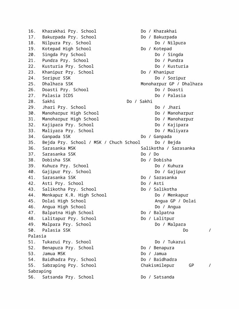
2. Gohemidanga High School ground, JL-8793. Dharampur School ground, JL-8674. Nachinpur High School, JL-5715. Belatikri Jamda Road, 7626. Rana Rani High School, JL-7357. Kantapahari Football ground, JL-5918. Binpur Hospital Ground, JL-4269. Andhari R.B. High School, JL-945
Sabong
1. Pallishree Rice Mill at Lutunia,JL-1232. Place of Bus stand at Dehati, JL-3193. Football ground of Sabong S.M.High School, JL-2934. Football ground of Dasagram HighSchool, JL-3185. Football ground of Julkapaur near Block S. Farm,JL-1786. Football ground of Chandkuri High School, JL-1697. Football ground of Chaulkuri Jr. High School, JL-3628. Football ground of Tilantapara High School, JL-248
Narayangarh
1. Chakmukunda Basanti Vidyapith2. Playground of Uttar Parulia Primary School3. Playground of Gama Primary School4. Ground of Gouranga Rice Mill at Belda5. Ground of Narayangarh Lakshmi Narayan Rice Mill
Pingla 1. Jalchak N.N. Vidyatan High School Ground2. Mundamari U.N. Vidyapith School Ground
Dantan-II 1. Sauri Bholanath Vidyapith,2. Jhalda High School & Play ground of Betarui Pry. School
Debra
1. Trilochanpur K.K. High School2. Golegram R.B.B.M. H.S. School3. Beulasini High School4. Bhabanipur High School5. Bhajahari Insitiution6. Debra Herimati Saraswati Bidyamandir7. Flood Shelter Golegram8. Lowada High School9. Marhtala Satyeswar Institution
Kharagpur –II1. Janardanpur High School Ground.2. Sankoti Rice Mill.3. B.D.O. Office compound
Pingla
1. Jalchak High School ground, JL-2362. Pingla College ground , JL-833. RagpurHat at Gobardhanpur4. Pindrui High School ground, JL-2095. Gobardhanpur High School, JL-2046. Pingla Football ground7. Barisha Bridge, JL-2338. Saracha High School, JL-2019. Lakshmipur Bazar, JL-227
Mohanpur 1. Mohanpur Solapatta Road near Gomunda 2. Dhuipara High School Play Ground.
Midnapore Sadar 1. Hati Halka, JL-2102. Mahatabnagar, JL-2503. Bajpara, JL-2764. Tala Palsia, JL-2785. Pathra, JL-2486. Raghunathpur, JL-2717. Ayma Danga, JL-2188. Harishpur, JL-2069. Birsingpur, JL-215
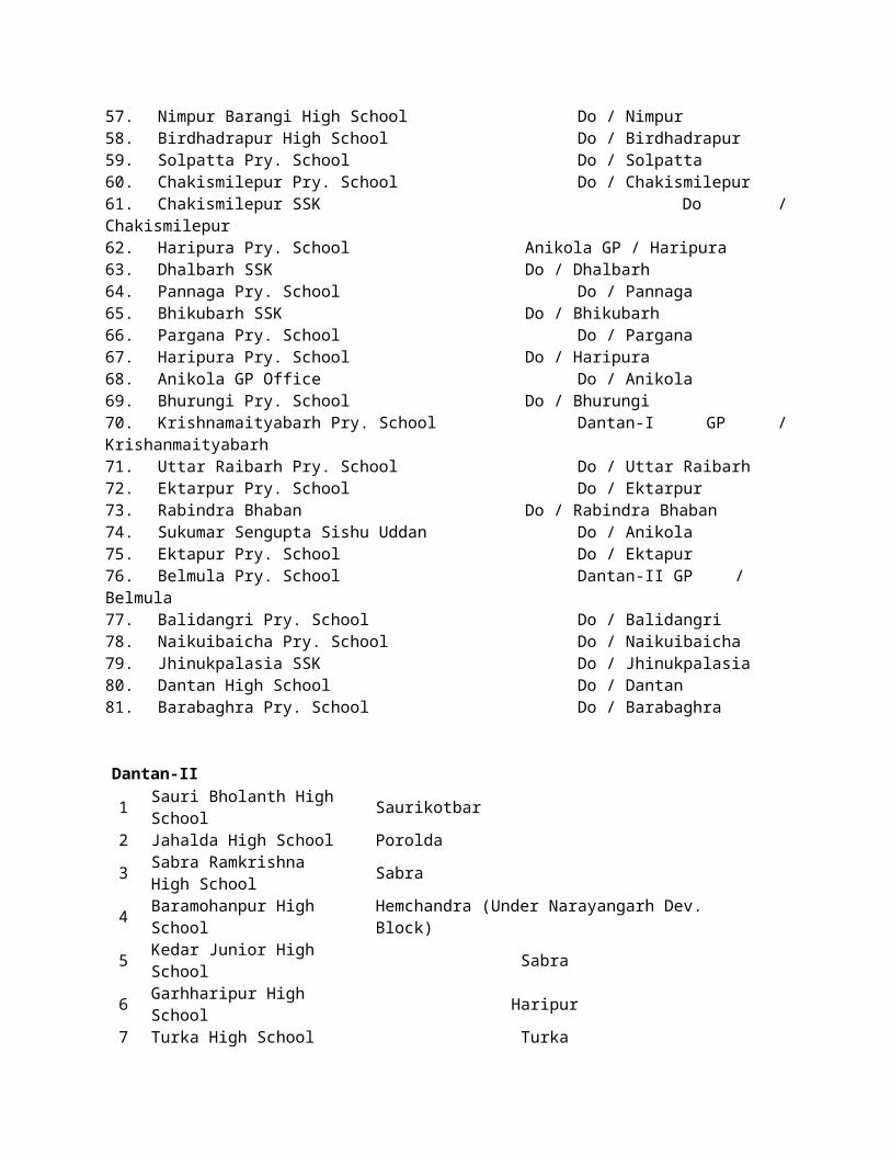
10. Dherua, JL-28
Garbeta-I
1. Sandhipur S.S. High School, JL-8942. Sanmura V.S.S. High School,JL-8083. Mohanpur Primary School4. Dhadika Jr. High School, JL-5595. Banerjee Danga High School6. R.K.Mission Jr. High School7. Nohari High School, JL-5038. Monglapota High School, JL-6379. Fulmanipur Moulara Sarat Chandra Jr. School10. Garbeta High School, JL-57011. Moyta Jr. High School, JL-395
Garbeta-II 1. Hoomgarh Chandabila High School ground, JL-2792. Lal Bahadur Shastri Jr. H.S.School ground, JL-247
Keshpur
1. Golar Pry. School 2. Mugbasan High School3. Bajuara Pry. School4. Mundalika Pry. School5. Gobindapur Pry. School6. Jagannathpur Pry. School7. Kotai Pry. School8. Amrakuchi Pry. School9. Panchami Pry. School10. Nagda Pry. School11. Louria Pry. School12. Keshpur High School13. Sorai Pry. School14. Kalagram High School15. Chhutergeria High School16. Kanchantala High School17. Mogra Pry. School18. Sarishakhola GP Office19. Ghoshpur High School20. Dhalhara High School21. Parulia Pry. School22. Khasbarh High School23. Jhentla High School24. Biswanathpur Pry. School25. Pakuria Pry. School26. Ghoshdiha High School
Ghatal1. Dewanchak Primary School2. Irpala High School3. Jalsara High School4. Sri Aurobinda Stadium at Ghatal
Daspur-I
1. Talibhata Football ground2. Kalara Football ground3. Rajnagar High School4. Daspur Football ground5. Narajole High School6. Nimtala Football ground7. Nandanpur High School
Daspur-II
1. Khukurdaha High School ground, JL-1502. Gopiganj Irrigation Bungalow, JL-2193. Chaipat High School(Roof), JL-2164. Sonakhali High School Roof, JL-1725. Jyoteghanashyam High School, JL-2406. Sreebara High School, JL-247
Chandrakona-I 1. Chandpur High School
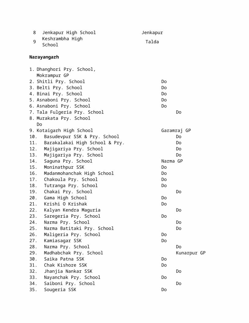
2. Municipal Ground at Khirpai
Chandrakona-II 3. Basanchhara S.H.C. Ground 4. Chandrakona Jirat High School ground
6.7 PREVENTIVE AND PREPARATORY MEASURES OF IRRIGATION & WATERWAYS DIRECTORATE WEST MIDNAPORE DIVISION
A) The following River Gauge & Rain Gauge Station has been maintained by this Division.
Sl. No.
Station River PDL (M)M.G.T.S.
D.L. (M)M.G.T.S.
E.D.L. (M)M.G.T.S.
HFL(M)
Remarks
1. Midnapore Rain Gauge2. Mohanpur Kangsabati /
Cossye25.45 25.75 26.36 RIver Gauge
3. Saldahari Old Cossye 15.39 16 16.61 River Gauge4. Gopiballavpur,
Asui DharampurSubarnarekha 46.26/45.00 46.87/45.50 47.40/46.50 Rain Gauge &
River Gauge5. Gadhat Silabati 8.38 8.99 9.60 11.12 Rain Gauge &
River Gauge6. Banka Silabati 14.17 15.08 15.69 16.34 River Gauge7. Bandar Rupnarayan 6.24 6.85 7.46 9.47 River Gauge8. Ranichak Rupnarayan 4.72 5.33 5.94 9.14 River Gauge9. Gopiganj Rupnarayan 4.42 5.03 5.65 8.41 River Gauge10. Old Cossye Kalmijore 8.68 9.29 9.90 11.12 River Gauge
B) Reporting of River Gauges & Rain Gauges at different Authorities: Rain gauge stations are maintaining under this Division at i) Midnapore, (ii) Gopiballavpur, (iii) Gadhhat.Daily river gauge reports are to be collected from C.W.C. in connection with Kangsaboti Project. River & Rain gauge data will be prepared as per approved format and weekly format as per G.F.C.C. Proforma and sent to the following authorities.
i) District Magistrate, Paschim Medinipur.ii) Chief Engineer’s flood cell.
C) Weekly flood inspection report :Weekly flood report is to be submitted by the concerned Sub-Divisional Officer as usual following last year’s procedure.
D) Stock Position :
1) The stock position of empty cement poly bags at different stations are as follows:a) Lachmapore Irrigation Sub-division :
i) Lachmapore Section - 2000 nos.ii) Khanamohan Section - 65000 nos.iii) Anicut (Hd. Qtr.) Section - 24400 nos.iv) Balichak Section - 5000 nos.v) Anicut Section - Nilvi) Simlageria Section - 1000 nos.
b) Jhargram (I) Sub-Division :i) Jhargram (Hd. Qtr.) Section - Nilii) Gopiballavpur (I) Section - 10600 nos.
c) Ghatal (I) Sub-Division :
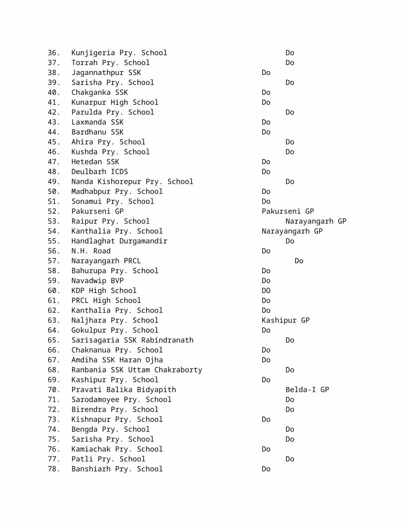
i) Dushaspur-I - 400 nos.ii) Dushaspur-II - 28000 nos.iii) Ghatal - 3300 nos.iv) Ajuria - 48300 nos.
2) The stock position of Nylon Crates at different sections as follows :
a) Lachmapore Irrigation Sub-Division: 1848 nos.
i) Anicut (Hd. Qtr.) Section - Nil
b) Ghatal (I) Sub-Division :
i) Ajuria - Nil
E) Hiring of boats and operating, regulating and fall boards :
a) Quotation for hiring of boat will be invited and sent to the Division Office within 15 th June-2014. Work order may be issued as and when situation arises (1 No. boat will be hired at Khanamohan).
b) Quotation for operating regulator gates and guarding and operation of fall boards will be invited and send to the Division Office within 15th June- 2014. Work order may be issued as and when situation arises.
F) Sealing of sluices, unauthorized pipes :
Work order for sealing of sluices and unauthorized pipes will be given by the concerned authority within 15.06.2014. (6 Nos. sluice required to be sealed in TE2H2 embankment).
G) FLOOD FIGHTING WORKS
Flood fighting works will be undertaken as and when necessary under prior intimation to The District Magistrate and obtaining permission from higher official of I&W Dte.
In the event of any breach, report will be at once transmitted to Sabhadhipati & Karmadakshya, Paschim MediniPur Zilla Parishad, Block Development Officer of concerned Block & Sub Divisional Officer of concerned Sub Division & Higher officer of I&W Dte.Repair of breach can only be taken with prior permission of Government with written requisition fromThe District Magistrate and Sabhadhipati to take up such work.
H) Flood embankments :
Latest position of embankments
The restoration works on the embankments of river Cossye which were severely damaged on flood- 2013 has been mostly completed. Some further works are to be taken up & completed before onset of monsoon to bring the whole matter at affordable stage if necessary funds are available.
At Ghatal (I) Sub-Division breached portion of MC & DC embankment has been repaired.Further FPM work will be taken up soon.
I) Name of embankments under West Midnapore Division :
a) Lachmapore Irrigation Sub-Division :Sl. Name of River Name of embankment Chain age From Length From--------To
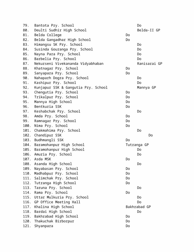
No. …………1. Cossye Kalichandi Flood
Embankment (1st Phase)0.00 Km to 7.10
Km 7.10 Km Srirampur to Amodpurpal
2. Cossye Kalichandi Flood Embankment (2nd Phase)
0.00 Km to 17.00 Km 17.00 Km Patra Bridge to
Kalinagar Bridge
3. Kalaichandi Khal Kalaichandi Marginal 0.00 Km to 5.64 Km 11.28 Km Patra Bridge to
Elahiganj
4. New/Old Cossye TE1H1 0.00 Km to 40.00 Km 40.00 Km Okra to Lowada
5. Old Cossye TE2H2 0.00 Km to 14.00 Km 14.00 Km Malihati to Tinua
6. New Cossye TH3H3 14.00 Km to 26.00 Km 12.00 Km Tinua to Nandabari
b) Ghatal Irrigation Sub-Division :
Sl. No. Name of River Name of
embankmentChain age From
…………To Length From--------To
1.Old
Cossye/Kanki/Silabati/ Rupnarayan/Palashpai
KhalChetua Circuit 0.00 Km to 72.00 Km 72.00 Km
Katan Baundh - Ranichak-
Goura- Kasimjole-Katan
2.Durbachati (L/S) /
Rupnarayan (R/S) / Palashpai Khal (R/S)
Mohankhali Circuit 0.00 Km to 51.00 Km 51.00 KmSibora- Via Khukurda-
Goura- Sibora
3.Old Cossye/
Durbachati / Bhasra Khal
Dushaspur Circuit 0.00 Km to 30.00 Km 30.00 KmPostanka-
Kalmijole-Jotisab-Postanka
c) Asui-Dharampur (R/B of river Subarnarekha) – 2.70 Km.Sizua. Gopiballavpur - 2.70 Km.Kapasia-Mohanala - 0.90 Km.
J) Name of the Sluices :
a) Lachmapore Irrigation Sub-Division :
Under Khanamohan Section :
i) Talbandi Sluice, Ch 12.00 Km of TE2H2, L/B of Cossye.ii) Mokarimpur Sluice, Ch. 16.00 Km to TE3H2.iii) Gopalpur Sluice Ch 21.60 Km to TE3H2iv) Guapat Sluice Ch. 23.00 Km of TE3H2v) Baikunthapur Sluice Ch. 2.00 Km of TE2H2 L/B of old Cossye.
Under Anicut Section:
i) Bisripat Sluiceii) Kulda Sluice (Up & down)iii) Cherua Sluice (up)iv) Cherua Sluice (down) 2 vent.v) Birsingpur Sluice.vi) Jamkunda Sluice.vii) Pathra Sluice.viii) Hanshpur Sluice.ix) Paikarapur Sluice.
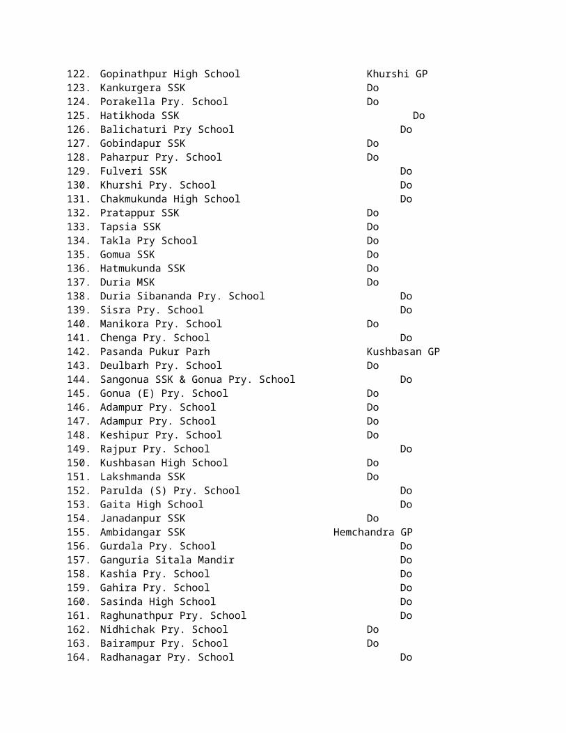
b) Ghatal Irrigation sub-division :
i) One no. sluice at Goura.ii) Total 52 nos. sluice at Ghatal Sub-Division.
K) Borrow Bundh:
b) Ghatal Irrigation Sub-Division :
There are three nos borrow bundh. Kalmijore borrow bundh & Temohani borrow bundh should be removed before onset of monsoon is extremely urgent.
L) Drainage Channel :
a) Lachmapore Irrigation Sub-Division.Under Khanamohan Section :
i) Rambhadrapur Ch. 12.90 of TE1H1.ii) Tabageria Ch. 28.90 of TE1H1.iii) Bhudhas Ch. 30.00 of TE1H1.iv) Ghunghuni Ch. 30.00 of TE1H1.
M) Name of officers with designation :
Sl. No. Name of Officer Designation Mobile No. Location of office1 Subrata Mazumdar Excutive Engineer 9433464161
03222-275373(O) Sekhpura, Midnapore
2 Subhasish Bera S.D.O. Lachmapur 9434131058 03222-275306(O) Lachmapur Sub-Division
3 Pradip Kundu S.D.O. Jhargram 9932988259 Jhargram(I) Sub-Division
4 Namit Sarkar S.D.O. Ghatal 947445032103225-255096(O) Ghatal (I) Sub-Division
5 Ashis Kr. Hazra Sectional Officer 9434989256 Estimating Section6 Pranab Kr.Das Sectional Officer 9475115152 Mawa Section7 Naren Majumder Sectional Officer 9800186626 Simlageria Section,8 Shamba Guha Sectional Officer 9800171313 Balichak Section9 Mridul Kanti Mahapatra Sub-Assistant Engineer 9609358485 Estimating Section
10 Samir Kr. Nag Sectional Officer 9475119371 Khanamah- an Section11 Debasish Roy Sub-Assistant Engineer 9476328821 West Midnapur Division
12 Monojit Mahato Sectional Officer 9836689636 Hd. Qtr.SectionJhargram(I)Sub-Division
13 Subir Ranjan Das Sectional Officer 8972942624 Gopiballav- pur & Lodhasuli Section14 Amit Kumar Nayak Sub-Assistant Engineer 9635899023 Investigation Sub-Division15 Nandalal Kar Sectional Officer 9434705248 Lachmapur Section16 Rasbehari Pal Sub-Assistant Engineer 9434899586 Estimating Section17 Ranjit Ghosh Sub-Assistant Engineer 9733831201 Lalgarh18 Swaraj Hait Sectional Officer 9474361644 Debra Section19 Sudeb Dolui Sectional Officer 9874135555 Hd. Qtr.Section Ghatal(I)Sub-Division20 Swapan Mandal Sectional Officer 9434185064 Dussaspur-I21 Dilip Pramanik Sectional Officer 9153214042 Dussaspur-II22 Paresh Chandra Maity Sectional Officer 9932508432 Ajuria
Vulnarable Zone
Khanamohan (I) Section of Lachmapore(I) Sub-Division under West Midnapore Division
Sl. Name of Name of Ch. In Km. Length Mouza/ P.S. Probable Remarks

No. River Embankment of work cost in Lakh
1River
Cossye R/B
TE1H12.00 Km. 250 Mtr. Rajsaw / KGP(L) 35.00 Bank erosion at
river has been observed
6.20 Km. 200 Mtr. Maheshpur / KGP(L) 30.0010.00 Km. 300 Mtr. Rajsaw / KGP(L) 40.0013.00 Km. 500 Mtr. Keshpur / KGP(L) 65.00
2River New
Cossye R/B
TE1H227.00 Km. 800 Mtr. Saldhari / Debra 100.00 Bank erosion at
river has been observed
31.00 Km. 200 Mtr. Raipur / Debra 30.0035.00 Km. 250 Mtr. Sarpur & Goyespur /Debra 35.00
3River Old
Cossye R/B
TE2H24.00 Km. 200 Mtr. Bhabanipur / Debra 30.00 Bank erosion at
river has been observed6.00 Km. 150 Mtr. Patna / Debra 25.00
Total 390.00 Lakh
Vulnerable Points of Ghatal (I) Sub-Division.
Sl.No. Chainage Mouza/Block Nature of Damage Approximate cost per Prefication
1 53-54, C.C` Dadpur 130m slip 35.00 Lakh2 47-48, C.C Kalorah 170m slip 40.13 Lakh3 17-18, M.C Khukurdaha/ Majipara 110m slip 32.74 Lakh4 15-16, M.C Brindabanchak / Mandal Para 170m slip 51.00 Lakh5 14-15, M.C Brindabanchak / Sow Para 120m slip 41.00 Lakh6 17.50-18.50, D.C Rabidaspur & Chaksundar 1000m, weaker section 65.00 Lakh7 18.50-30.50, D.C Dharma & Paikanboalia 12 km. weaker section 60.00 Lakh8 25.60, D.C Kakdori sluice damage 22.00 Lakh9 3.80-4.00 KM, D.C Sriampur 200m slip 40.00 Lakh
10 13.0 -14.0 KM. C.C Jalekanuramgarh / Daspur-II 35m land slide 21.74 Lakh11 13.0-14.0 KM., C.C Jalekanuramgarh / Daspur-II sluice damage 16.27 Lakh12 5.0-6.0 KM., C.C Pratappur/ Ghatal 35m land slide 21.46 Lakh13 57.0- 58.0 KM., C.C Jadupur / Daspur -I 40m land slide 23.47 Lakh14 60.0-61.0 KM., C.C Anandagarh / Daspur-I 135m land slide 48.93 Lakh
15 36.0-37.0 KM., C.C Palaspai / Sahapara & Bhuktapara / Daspur-II 2nos. Ghoges 2.00 Lakh
16 37.0-38.0 KM., M.C Sitapur & Joteghanashyam/ Daspur-II 2nos. Ghoges 2.00 Lakh
17 38.0-39.0 KM., M.C Joteghanashyam/ Daspur-I 1no. Ghoge 1.00 Lakh18 29.0-30.0 C.C Gomrai / Daspur-II slice flapshutter (4 nos.) to
be fixed & G/arrangement 5.00 Lakh
19 29.0KM.31.0-32 KM Goura sluic / Rampur Sluic
sluic E/ wall W/R to be raised & top slab to
extended5.00 Lakh
Total :- 533.74 Lakh
6.8 ANNUAL ACTION PLAN OF KALIAGHAI-KAPALESWARI-BAGHAI PROJECT DIVISION UNDER WESTERN CIRCLE – II, I&W DTE. TEMATHANI, SABONG, PASCHIM MEDINIPUR
The following arrangements have been programmed for Flood Preparedness-2014 under Kaliaghai-Kapaleswari-Baghai Project Division, I & W Dte., Midanapore, Paschim Medinipur. :-
A. OPENING OF R.T.STATIONS:-

It has been programmed that R.T.Sets are to be installed within 1st June, 2014 at the following places this year.
a) Bhakrabad..............................Over Kaliaghye River.b) Dehati.....................................Over Kaliaghye River.c) Narayanbarh...........................Over Kapaleswari River.
B. RIVER GAUGE & RAIN GAUGE STATIONS:-
SlNo. Stations River P.D.L.(M)
M.G.T.SD.L.(M)M.G.T.S
E.D.L.(M)M.G.T.S
1 Bhakrabad (on Contai Road) Kaliaghye 7.95 8.40 8.852 Dehati (on Patashpur Road) Kaliaghye 5.95 6.55 7.003 Kalimondop Kaliaghye 4.40 5.00 5.604 Narayanbarh Kapaleswari 4.72 5.33 5.94
C. PREPARATION OF GAUGES:- Painting of gauges where necessary will be been taken up and completed by 31 st. May-2014. River Gauge Stations are to be maintained by the Kaliaghai Kapaleswari Baghai Project Sub-Division No.- I (Bhakrabad & Dehati ) and Kaliaghai Kapaleswari Baghai Project Sub-Division No.III (Kalimondop & Narayanbarh ). Rain Gauge Stations is to be maintained by the Kaliaghai Kapaleswari Baghai Project Sub-Division No.- III under this Division at Sabong.
River & Rain Gauge data will be prepared as per approved format of G.F.C.C. proforma and sent to the Higher Authority daily/weekly.
D. WEEKLY FLOOD REPORT:-Weekly flood report is to be submitted by the concerned Sub Divisional Officer (K.K.B.Project Sub-Division
No.- III) as usual following last year’s procedure.
E. PRE FLOOD INSPECTION REPORT:-Flood Inspection Report is to be submitted by the concerned Sub Divisional Officer under this Division
before 15.06.2014.
F. CONTROL ROOM:- Control Room will be opened on & from 15.06.2014 like every year in the K.K.B. Project Sub Division No.-III Office at Sabong as usual. Sub-Divisional Officer/ K.K.B. Project Sub Division No.-III will prepare the Roster Duty Chart for control room duty. .
G. STOCK POSITION OF EMPTY POLY BAGS & NYLON CRATES:- As reported by the Sub Divisional Officers and Sub Assistant Engineers (regarding stock) –
A. The Stock Position of Poly bags at different stations are as follows: (i) Kaliaghai-Kapaleswari-Baghai Project Sub Division No.- I = 55,913 nos.(ii) Kaliaghai-Kapaleswari-Baghai Project Sub Division No.-III = 60,000 nos.
B. The Stock Position of Nylon Crates at different stations as follows:(i) Kaliaghai-Kapaleswari-Baghai Project Sub Division No.- I = 945 nos.(ii) Kaliaghai-Kapaleswari-Baghai Project Sub Division No.-III = 400 nos.
H. HIRING OF BOATS & OPERATING REGULATOR GATES AND FALL BOARDS:-a) Quotations for hiring of boat will be invited by the concerned Sub-Division and sent to the Division Office within
15th June-2014. Work order may be issued as and when situation arises.b) Quotations for operating regulator gates and guarding & operation of Fall Boards will be invited by the
concerned Sub-Division and sent to the Division Office within 15 th June-2014. Work order may be issued as and when situation arises.

I. SEALING OF SLUICES, UNAUTHORISED PIPES:-
Work Oder for Sealing of sluices and unauthorized pipes will be given by the concerned authority within 15.06.2014.
J. REMOVAL OF CROSS BUNDHS & FISHING PATTAS:-Cross Bundhs & Fishing Pattas on river bed are a vital part to create obstruction on drainage congestion of the rivers and channels mainly over river Kapaleswari & Kaliaghai on Sabong, Narayanbarh & Gobindapur, Gokulpur areas which should be removed within 15 th June -2014 with the help of Administration and the Department by a joint programme by canvassing the local people and removing those obstruction. Kind Co-operations will be solicited from the local public representatives, B.D.O. of concerned block and administration to overcome the obstruction for public interest and to avoid the flood situation on flood prone areas.
K. VULNERABLE ZONES:- The Embankments under this Division have been severely damaged on Flood during 2008 &2011 on the river Kaliaghai & Kapaleswari. The repair works have been completed in. After that the balance works i.e. resuscitation & protection works have already been started and expected to be completed in due time. But the Ex-Zamindary embankments which are handed over to us is now in the process on transfer the jurisdiction from the concerned B.D.O. should be keeping up properly to avoid massive flood situation with top priority. Instead of that some of the Ex-Zamindary embankments have already been repaired & strengthened during the resuscitation works of few khals. L. FLOOD FIGHTING WORKS:-
Flood fighting works will be undertaken as and when necessary under prior intimation to District Magistrate after obtaining permission from Higher Official of I & W Dte.
In the event of any Breach, report will be at once transmitted to Sabhaddhipati & Karmadakshya, Paschim Medinipur Zilla Parishad & Purba Medinipur Zilla Parishad, Block Development Officer of concerned Block & Sub Divisional Officer of concerned Sub Division & Higher Officer of I & W Dte. Repair works will only be taken up with prior permission of the Government with written requisition from District Magistrate and Sabhadhipati of concerned Block to take up such work.
M. Latest Position of Embankments:-The restoration works on the embankments of river Kaliaghai, Kapaleswari which were severely damaged during the Flood of 2008 & 2011 have been completed. Some further repair & restoration works of the embankments which were damaged due to excessive rainfall occurred during the monsoon of 2013 have been taken up & some will be taken up and completed before onset of Monsoon to bring the whole matter at affordable stage.
6.9 ACTION PLAN OF FOOD & SUPPLIES DEPARTMENT
Rolling reserve the stock of Rice will be build up at the Godowns of MR Distributors in the flood prone areas of the District.
1. Rolling reserve a stock of Rice :-
To build up rolling reserved stock of Rice (Procured Rice-Common boiled) at the Godowns of M.R. Distributors in the flood prone areas of the District.
The said Rice will be handed over to the S.D.O.s / B.D.O.s as and when necessary subject to its replenishment forthwith by special G.R. Rice of the same variety.
2. Reserve a stock of K. Oil: -
To build rolling reserve stock of K. Oil @ 500 Ltrs. / Big Dealer and @ 5 K.L. / K. Oil Agent in the vulnerable pockets of this District.
The said reserved stock will be made available out of normal monthly quota by adjusting scale of
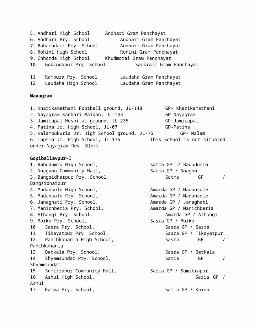
distribution if necessary in consultation with S.D.O.s. Necessary instruction to this effect will be issued to the Sub-Divisional Controllers.
3. Stock of foodgrains (Rice) in Govt. Godowns :-
Government Food Depots at Balichak, Belda, C.K. Road, Midnapur & Jhargram will have enough stock for providing in case of necessity.
Present stock position of procured Rice (common-boiled) in the said Godowns including 8 (Eight) Hired Private Godowns at Balichak, Jhargram Belda & C.K. Road is about 29000 M.T. as shown below.
Sl. No. Name of Godowns Storing CapacityGovernment Godowns1. Midnapur GFD 2100 M.T.2. Balichak GFD 650 M.T.3. C.K. Road GFD 800 M.T.4. Belda GFD 500 M.T.5. Jhargram GFD 500 M.T.Total: 4550 M.T.
Hired Private Godowns1. Haripada Rice Mill Hired Godown, Balichak 1500 M.T.2. CWC C.K. Road 4500 M.T.3. CWC Belda 5100 M.T.Total: 11100 M.T.Grand Total: 15650 M.T.
6.10 ACTION PLAN OF SUPERINTENDENT OF POLICE, PASCHIM MEDINIPUR
The following Action Plan has been taken to combat flood / cyclone etc. in Paschim Medinipur District.
A) A District Police Disaster Management Group may be formed comprising -
i) Addl.SP (HQ), Paschim Medinipur as Nodal Officer.ii) All zonal Dy.Ss.P. Paschim Medinipur.iii) All CIs of Paschim Medinipur.iv) All ICs / OCs of Paschim Medinipur.v) OC Control Room, Paschim Medinipur.vi) R.I. Paschim Medinipur.vii) M.T.O. Paschim Medinipur
B) ICs and OCs in co-ordination with B.D.M.O., B.D.O. will collect prior intelligence on probable disaster and cater the same to all zonal superiors and OC Control Room.
C) After commission of disaster ICs / OCs of PSs shall take part in rescue operation in consultation with respective B.D.O.s with available force and officers.
D) ICs / OCs after consulting with zonal superiors and examining the gravity of disaster shall open a Control Room in the Disaster affected place.
E) Such Control Room shall have all facilities as per standard rule.F) Control Room shall have a G.D. Book for recording grievance and annals of loss of property of disaster
affected people. G) Escort for food and other relief materials shall be provided by the respective ICs / OCs whenever
sought for.H) Security to relief camp shall be provided by ICs / OCs whenever sought for.I) R.I. Paschim Medinipur shall provide additional force and officer.J) M.T.O. Paschim Medinipur shall provide vehicle for movement of force and officer and escort of
vehicle carrying relief materials.

K) OC Control Room shall cater all information to all concerned.L) CIs shall personally supervise all activities of PSs regarding rescue operation, ensure that no untoward
incident takes place at the time of distributing relief materials and ensure security of relief camp.MOBILE NUMBER AND LAND LINE TELEPHONE OF POLICE OFFICERS AND POLICE STATIONS IN PASCHIM
MEDINIPUR DISTRICT
Contact details of Superintendent of Police
Name & Designation of SP Tel No. Fax No. Mobile No. E-mail ID
Sheesh Ram Jhajharia, IPS, Paschim Medinipur 03222-275609 03222-274298 9836832777 [email protected]
Alok Rajoria, IPS, Jhargram 03221-255192 03221-255192 9051217042 [email protected]
Contact details of SDPO
NAME OF SDPO Tel No. Fax No. Mobile No. E-mail ID
Shri Ajeet Singh Yadav, IPS, SDPO-Kharagpur 03222-255973 7407000666
Shri Manoranjan Ghosh, DySP(Admn) 03222-271318 03222-263598 9836793924
Shri Soutam Banerjee, DySP(Oprns) 03222-263526 03222-263598 9477160045
Shri Shymal Kr. Mondal, DySP(D&T) 03222-273893 03222-263598 9836406889
Shri Debojyoti Chakraborty, DySP(Crime) 03222-271318 03222-263598 7407091155
Shri Vivek Kr. Verma, WBPS 03221-255072 03221-255072 77972044447797192192
Contact details of Inspector/Sub-Inspectors of Police Station
NAME OF POLICE STATION
NAME OF OFFICER IN CHARGE OF POLICE STn.
Tel No. Mobile No.
Kotwali Inspr. Susanta Rajbanshi 03222-275716 9434230994Keshpur SI Dayamoy Majhi 03227-250233 9733746424Anandapur SI Uttam Kr. Debnath 03227-252100 9474065418Salboni Inspr. Mihir Kr. Dey 03227-285228 9434215581Garhbeta SI Hirak Biswas 03227-265028 7872222273Goaltore Inspr. Akhil Ch. Malakar 03227-288235 9831445365Lalgarh Inspr. Gayndeo Prasad Shaw 03221-263202 9564808800Kharagpur (Town) Inspr. Dipak Sarkar 03222-255967 7407097755Kharagpur (Local) SI Raj Sekhar Pain 03222-227841 9874759807Dantan Inspr. Mihirlal Naskar 03229-253236 9836075556Mohanpur Inspr. Md. Jafrul Mallick 03220-232233 9434454946Keshiary Inspr. Prabir Kr. Mukhopadhyay 03229-252218 9433412051Narayangarh SI Avijit Biswas 03229-258238 9732627070Belda SI Sudhangsu Sekhar Banerjee 03229-255240 9933157454
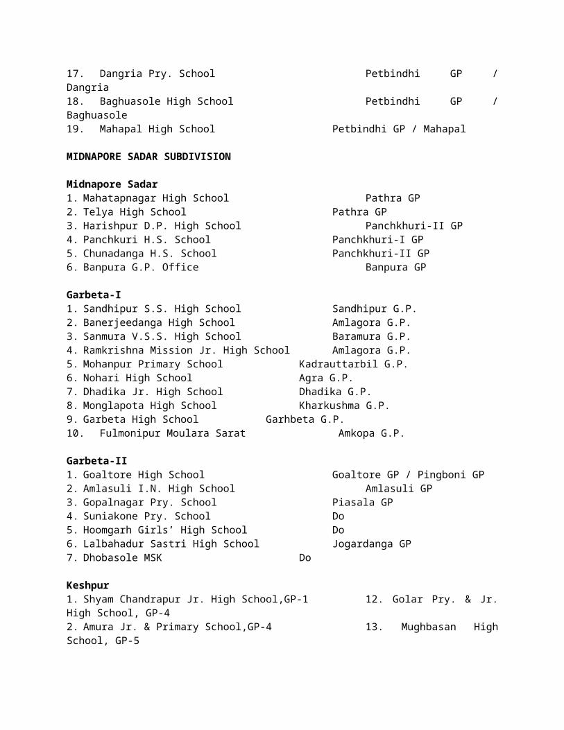
Debra SI Jayanta Chakraborty 03222-244246 9933632500Pingla SI Pankaj Kr. Mistry 03222-238546 9434414722Sabang SI Krishnendu Hota 03222-249201 9434414701Ghatal SI Sudip Ghosal 03225-255021 9933928922 /
9830725700Chandrakona SI Ashis Jain 03225-266250 9475862835Daspur SI Shymal Das 03225-254239 9735608060Belpahari Inspr. Shri Nirmal Kr. Majhi 03221-253202 7797176176Binpur Inspr. Shri Suman Chatterjee 03221-260202 7797175175Jhargram Inspr. Shri Tanaji Das 03221-255002 7797172172Jamboni Inspr. Shri Arun Kr. Bagdi 03221-265322 7797171171Beliabera SI Biswaranjan Banerjee 03221-261202 7797178178Sankrail SI Siddhartha Saha 03223-265237 7797177177Gopiballavpur Inspr. Shri Astik Mukherjee 03221-266202 8145400948Nayagram Inspr. Shri Sourav Chaudhuri 03223-267209 7797157157
6.11 ACTION PLAN OF F.P.I. & HORTICULTURE
National Horticulture Mission
Sl. No. Proposed Scheme for the year 2014-15 Local bodies
own resources
Resource provided by State
GovernmentTotal Remarks
1 Small Nursery (Pvt.) 3.125 12.50 3.125 12.502 Green House (Tubular Structure) - 18.70 - 18.703 Shed Net (Tubular Structure) - 18.00 - 18.004 Shed Net (Bamboo Structure) - 6.00 - 6.005 Perennial Fruits - 30.00 - 30.006 Non-Perennial Fruits (Banana) - 25.00 - 25.007 Vermicompost 2.25 9.00 2.25 9.008 Horticulture Mechanization - 18.00 - 18.009 Cut Flowers 1.575 10.50 1.575 10.50
10 Bulbous Flowers - 11.25 - 11.2511 Loose Flowers - 3.00 - 3.0012 Spices(Zinger & Turmeric) - 3.125 - 3.12513 Cashew nut Replanting - 10.00 - 10.0014 Rejuvenation of Cashew Nut - 7.50 - 7.50
15 Creation of Water Resources (20m x20m x3m) - 15.00 - 15.00
16 Cost of Planting Material & inputs of flowers for Poly House/Shed Net - 5.00 - 5.00
17 Training of Farmers - 2.00 - 2.0018 Low cost onion storage(25 Mt) - 2.5 - 2.519 Seminar / Mela 10.00 10.00
Total 16.95 207.075 16.95 207.075
Rastriya Krishi Vikash Yojana
Sl. No. Proposed Scheme for the year 2014-15
Local bodies own
resources
Resource provided by State Government Total Remarks
1 Mini Rotary Tiller 10.00 - 10.00
2 Banana Cultivation (Trad. & Non Traditional)
- 15.00 - 15.00
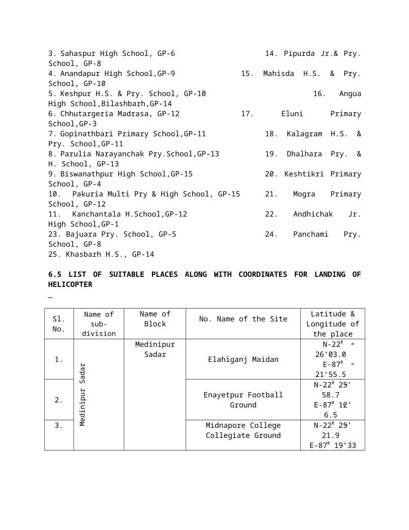
3 Drip Irrigation System - 18.75 - 18.754 Minikit Distribution of Zinger - 21.75 - 21.75
5 IVP through Hi-Tech. cultivation technique.
25 - 25 -
Water resources 15 - 15 -Total 40 65.50 40 65.50
6.12 ACTION PLAN OF SERICULTURE
Mulberry Sericulture is mainly concentrated in Debra block and part of Sabong, Pingla and Kharagpur-II blocks. The Muberry Plantation is also spread beside the embankment of river.The months of July to October are most vulnerable months likely to be affected by flood. The low lying areas are inundated by flood water & continued for some days. Prolonged water logging affects the leaf quality of mulberry as well as silk worm crops fed with the said mulberry leaves. Prolonged water stagnation in and around rearing houses causes damage of the house meant for silk worm rearing and the bamboo made implements.Either of the 2 (two) crops- Shravani & Aswina may be affected by the disaster. Around 90 acres out of 200 acres of Mulberry and nearly 200 nos of farmers may be affected.
1. Nature of damage :
a) Partial damage of rearing houses.b) Partial damage of rearing implements.c) Quality deterioration of plantation and mulberry leaves.d) Partial crop loss.
2. Extent of damage:
Total expected harvest may be to the tune of 15 MT worth Rs.12.00 Lakh. 20-30% may be affected, if prolonged stagnation of flood water remains.
3. Nature of steps needs to be taken :
a) Lump sum assistance to repair of the damage of rearing house and implements.b) Suppy of plantation inputs to rejuvenate quality leaves.c) Supply of rearing inputs to harvest a successful crop.d) Supply of basic seed (silk worm eggs) for successive crop.
4. Departmental provision to combat with the forthcoming situation :
a) Provision of Crop Insurance support.b) Provision of Health Insurance support.c) Department Infrasturcture available for arrangement of mulberry cutting and D.F. layings to revive
leaf crop and cocoon crop.d) Disinfectants (Bleaching, Sanitech etc.) may be available under the plan scheme.
6.13 ACTION PLAN OF HEALTH DEPARTMENT
Flood/ draught/ landslide preparedness, 2014 District – Paschim Medinipur
Name of affected blocks with health establishments based on last 5 years data
Sl No
Name of Affected
BlockNumber of affected GP
Number of affected
population
health establishments likely to be affected
RH BPHC PHC SC
1 Keshpur 11 2,52,958 0 0 1 12
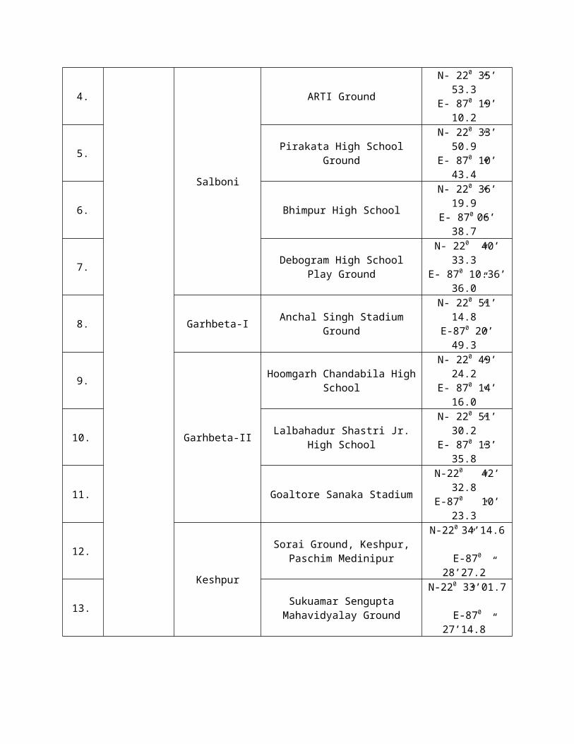
2 Mid sadar 5 1,16,746 0 0 1 5
3 Gopi I 5 64,845 0 0 0 0
4 Gopi II 5 76,021 0 0 0 0
5 Sankrail 8 69,014 0 0 0 6
6 Nayagram 5 52,251 0 0 0 0
7 KGP I 2 66,786 0 0 0 0
8 KGP II 2 48,161 0 0 0 0
9 Keshiary 2 37,145 0 0 0 4
10 Narayangarh 8 1,47,938 0 0 0 15
11 Dantan I 4 72,992 0 0 0 12
12 Dantan II 2 45,658 0 0 0 0
13 Bagda 1 21,520 0 0 0 1
14 Debra 9 3,66,120 0 0 0 6
15 Sabang 13 2,69,877 0 0 1 21
16 Daspur I 6 1,78,658 0 0 0 3
17 Daspur II 6 1,07,318 0 0 1 3
18 Ghatal 12 2,12,947 0 0 1 15
19 CK I 4 74,184 0 0 0 0
Total 110 22,81,139 0 0 5 103Keshpur – PHC – Dhalhara. SC – Gopinathpur, Dabageria, Biswanathpur, Chotoposa, Noldihi, Satenga, Jhentla, Dhalhara, Kanchantola, Ghoshpur, Digha,Basanchawk.Mid Sadar – PHC – Pathra, SC – Pachra, Bajpara, Gobindanagar, Harishpur, Hati Halka.Sankrail – SC – Murakati, Anandapur, Rohini, Dahi-banpura, Andhari(N), Chholaberia.Keshiary – SC – Bagasty, Nochipur, Bhasra, Baglata Narayangarh – SC – Raipur, Gonua, Kesbasan, Metai, Kashipur, Markunda, Turanga, Purasotyommpur, Bansarisha, Bakrabad, Khalina, Akanda, Kasba, Handiaghat, Bahurupa Dantan I – SC – Antri, Rajnagar, Maljamuna, Charda, Katapadi, Palsondapur, Tararul, Jamua, Panitunia, sonakonia, Bhabanipur, Barabagra.Bagda – SC – Keoutkhalisa Debra - SC – Bhabanipur, Shyamnagar, Bharatpur, Sinua, Satyapur, Haridrapath Sabang – PHC – Kharika, SC- Debang, Uchitpur, Jhalkapur, Danrah, Kanisole, Madkatpur, Khepan, Kelyapur, Harihat, Ruinan, Nimkimahar, Debrajpur, Bishnupur, Jagannathchak, Lakepith, Anbigeria, Kilantapara.Daspur I – SC – Dubarajpur, Narajole, Kantadarja Daspur II – PHC - Chaipat SC – Kamalpur, Ramkrishnapur, Jotghanashyampur (East & West)Ghatal – PHC – Khasbarh SC – Monsuka, Dirghagram, Rathipur, Silarajnagar, Chaksadi, Maharajpur, Kuthikonapur, Panna, Joynagar Sripur, Jalsara, Birsingha, Radhanagar, Dandipur, Natuk
Name of affected blocks with health establishments based on last 5 years data
Sl No
Name of Affected Block Name of affected GP
Number of affected
population
Health establishments likely to be affected
RH BPHC PHC SC
1. Keshpur Partly Golar 25558
Partly Mugbasan 26736

Partly Sahaspur 26730
Partly Amrakuchi 23126
Partly Anandapur 22719
Fully Keshpur 22593
Fully Kalagram 20153
Fully Sarisakola 23364
Fully Dhalhara 19341 1
Fully Jhetla 20864
Fully Enayatpur 21775
Total 11 Nos 252958
2. Midnapore Sadar
Panchkuri GP-6/2 21148
Pathra GP-8 25153 1
Banpura GP-7 22737
Siromoni GP-5 27528
Monidaha GP-3 20180
Total 5 Nos 116746
3 Gopiballavpur I
Satma 10901
Amarda 10388
Sasra 16605
Gopiballavpur 16640
Alampur 13354
Total 5 Nos 64845
4. Gopiballavpur II
Chorchita GP-1 11326
Kharbandi 12379
Beliabera 18747
Petbindi GP-7 20098
Kuliara GP-4 13471
Total 5 Nos 76021
5. Sankrail Dhanghori-1 9518
Rogra-2 13348
Andharia-3 9418
Rohini-4 17930
Chhatri-5 10524
Pathra-6 11569
Kudmoria-7 9028
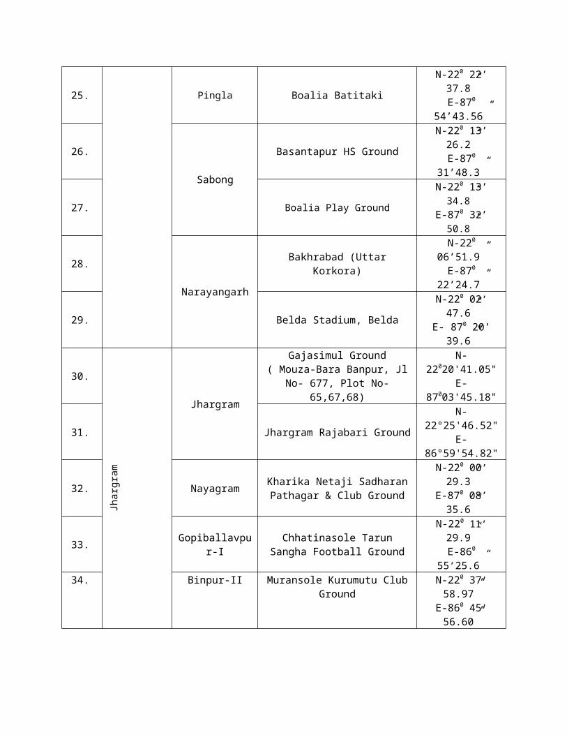
Laudaha-9 10545
Total 8 Nos 69014
6. Nayagram
Patina 9314
Barakhakri 11806
Malam 10430
Nayagram 11614
Jamirapal 9087
Total 5 Nos 52251
7. Kharagpur IKalaikunda GP-IV 33518
Borkola GP-VII 33268
Total 2 Nos 66786
8. Kharagpur II3 No Lachmanpur 30985
5/1 Kaliara 17176
Total 2 Nos 48161
9. KeshiaryBaghasty 19065
Nachipur 18081
Total 2 Nos 37145
10. Narayangarh
Khurshi GP-14 37145
Kushbasan 19090
Hemchandra 20852
Turanga 20197
Narayangarh 20389
Kashipur GP-7 23434
Bakhrabad GP-13 17103
11 No GP 13922
Total 8 Nos 12952
11. Dantan I
GP1 (Alikosha) 147938
GP2 (Tararui) 21029
GP5 (Angua) 17376
GP9 (Dantan 11/9) 20552
Total 4 Nos 14036
12. Dantan IIShyamsundarpur 20435
Sabra maktab 25223
Total 2 Nos 45658
13. Bagda Mohonpur Siyalsai GP-2 21520
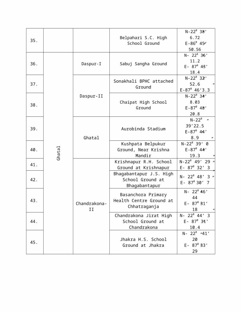
14. Debra
1 no Bhabanipur 41612
2 no Bharatpur 41223
3 no Satyapur 46824
7 no Malighati 37733
8 no Golgram 46026
9 no Lowada 48000
6 no Jalibanda 50526
10/1 Duan 25644
10/2 Duan 28532
Total 9 Nos 366120
15 Sabong
1no. Debhog 23243
2no. Malpar 17310
3no Danrra 21799
4no Dasgram 17637
5no Sartta 18552
6no Chaulkuri 16780
7no Narayanbarh 19522
8no Sabong 24262
9no Balpai 19762
10no Bhemua 20034
11no Mohar 26620
12no Bural 20249
13no Bishnupur 24836
Total 13 nos 269877
16. Daspur-I
Narajole 31156
Rajnagar 28324
Nandanpur I 31020
Nandanpur II 28639
Sarberia I 27991
Sarberia II 31528
Total 6 Nos 178658
17. Daspur-II 2no Kamalpur 19102
3no Ranichwak 11043
6no Benai 17798
10no Palaspai 14217

13no Jotghanashyam 22992
14no Dudhkumra 22167
Total 6 Nos 107318
18. Ghatal
Sultanpur(1no) 22774
Dirghagram (3no) 16168
Mansuka2 (4no) 11107
Birsingha (5no) 24834
Mohonpur(6no) 30225
Dewanchak1 (7no) 17370
Dewanchak2 (8no) 16073
Ajabnagar1(9 No) 17380
Ajabnagar2 (10no) 15279
Manoharpur1(11no) 15254
Manoharpur2(11no) 13583
Irpala 12903
Total 12 Nos 212948
19. Chandrakona-I Mohanpur-I (5No) 12976
Mohanpur-II (6No) 13612
3no Mangrul 21694
4no Mainikundu 25902
Total 4 Nos 74184
Substitute place planned for health establishments likely to be affected
Sl No
Name of the Health establishment likely to be
affected
Type of Health facility (DH/SD/SG/
RH/BPHC/ PHCAlternative place where service delivery is planned to be shifted
1. Dhalhara (Keshpur) PHC Dhalhara High School
2. Pathra (Midnapur Sadar) PHC Panchayat office Pathra
3. Barakalankai PHC Narayangarh PHC Panchayat office Barakalankai
4. Sabra (Dantan II) PHC Sabra High School
List of areas likely to be affected with proposed additional service point
Name of Block Population at risk
additional service point planned with probable name of the place like school, GP office etc.
Probable no of mobile medical teams required
Temporary medical OPD service points (name of
the place)
Temporary (24x7) medical service point with beds
(name of the place)
Keshpur 2,52,958
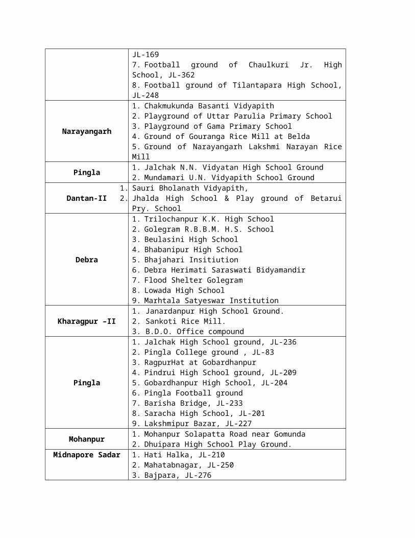
Midnapore Sadar 1,16,746
Gopiballavpur I 64,845
Gopiballavpur II 76,021
Sankrail 69,014
Nayagram 52,251
Kharagpur I 66,786
Kharagpur II 48,161
Keshiary 37,145
Narayangarh 1,47,938
Dantan I 72,992
Dantan II 45,658
Bagda 21,520
Debra 3,66,120
Sabang 2,69,877
Daspur I 1,78,658
Daspur II 1,07,318
Ghatal 2,12,947
Chandrakona I 74,184
Communication (District Level)
Activity Name of Nodal Office Mobile No Alternate responsible officer (in absence of Nodal Officer) Mobile No
Overall CMOH 03222-2756959434134956 Dy. CMOH - I
Reporting Dy. CMOH II 03222-2758549434205359 Dy. CMOH - I
Logistics (Drugs) Dy. CMOH I 03222-2732049775072018 Dy. CMOH - II
Logistics(Transport) Dy. CMOH I & RHTO 9775072018
9434318627 Dy. CMOH - I
Intersectoral coordination CMOH Dy. CMOH - II
Media Management CMOH Nominated by CMOH
Names of nodal officers1. Jhargram CMOH Dr. Swapan Kr Soren 9475563028
2. Jhargram DH Dr. Malay Adak Superintendent Jhargram DH 9433385264
3. Ghatal SDH Dr. Anuradha Deb 9732531130
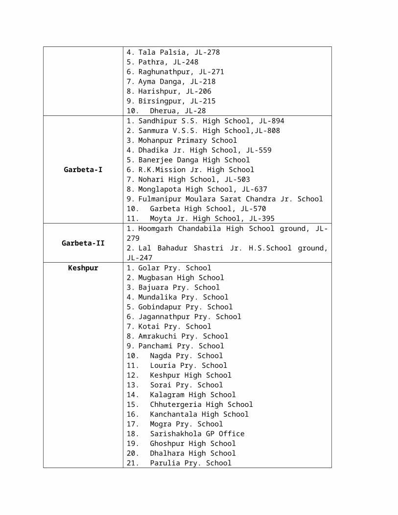
4. Kharagpur SDH Dr. Debasish Pal 9434414761
5. Ghatal Sub division Dr. Debdulal Mukherjee 9932647312
6. Sadar Sub division Dr. Tarapada Dhal 8967225181
7. Kharagpur Sub division Dr. Debasish Pal In-charge 9434414761
8. Jhargram Sub division Dr. Bhupatinath Majhi In-charge 9434709967
Names of nodal officers
Sl No Name of RH / BPHC Name of Supdt / BMOH Mobile number
1 Keshpur Dr. Tuhin Maity 9800032452
2 Midnapore Sadar Dr. Mousumi Som 9475940737
3 Gopiballavpur I Dr. Mahendranath Mandi 9474559804
4 Gopiballavpur II Dr. Manik Sing 9831399267
5 Sankrail Dr. Basab Bijoy Sit 9609951405/9239424620
6 Nayagram Dr. Santanu Tudu 9775376807
7 Kharagpur I Dr. Pampa Roy 9434722678/03222-277229
8 Kharagpur II Dr. Amitava Panda 9732585056/03222-295490
9 Keshiary Dr. Tarini Kr Sit 9434942198/03229-252226
10 Narayangarh Dr. Ashis Mondal 9434341384/03229-255268
11 Dantan I Dr. Mousam Manna 9003541540/03229-253251
12 Dantan II Dr. Durgapada Rou 9932884326
13 Bagda Dr. Anil Baskey 9734437885/03220-232204
14 Debra Dr. Rajat Kr. Pal 9231855387/03222-243229
15 Sabang Dr. Rajarshi Das 9674172455/03222-249204
16 Daspur I Dr. Sudip Kr Ghorai 9614768369/03225-254251
17 Daspur II Dr. Sankar Prasad Mahato 9732838150/03225-248308
18 Ghatal Dr. Projit Roy 9231712576/03225-262244
19 Chandrakona I Dr. Niranjan Kr Kurti 9932883776/03225-260240
Planning and deployment of Human Resource during flood / disaster situation
CategoryPresent availability (number) Manpower (10%) who can be
deployed to other place*
DH SD/SG Block (include RH & BPHC) DH SD/SG Block (include
RH & BPHC)
Specialist 20 42 4 2 5 0
Medical Officer 11 20 151 1 2 15
Nursing Staff 76 180 484 7 18 48

MPHW 0 0 1351 0 0 135
Requirement of Material-Drugs to treat population likely to be affected by flood/ disaster
Bleaching powder Halogen tablet ORS packet
Stock Need Stock Need Stock Need
DRS periphery DRS periphery DRS periphery
792 bag 100 bag 9,82,000 10,00,000 2,58,300 1,00,000
Normal Saline Ringer lactate Injection AVS
Stock Need Stock Need Stock Need
DRS periphery DRS periphery DRS periphery
14,000 4,000 15,000 5,000 1580 vial 2500 vial
Requirement of Material- Transport (to serve area & population likely to be affected by flood)
(FOR 2 WEEKS)
Motor Vehicles – No. 50 Vehicle X 28 days (Approx)Hiring charge – @ 2000/- per day = 28,00,000Boats-No. 20 X 14 days (Approx)Hiring charge – @ 1000/- per day = 2,80,000Others-Type of vehicle- 1. Motor Bike No – 50 X 14 days (Approx)Hiring charge – @ 700/- per day = 4,90,0002. Van Rikshaw No – 25 X 7 daya (Approx)Hiring charge - @ 400/- per day = 70,000 3. Contingency 2,00,000 4. Awareness, IEC Etc 2,00,000 Total amount required as contingency cost: 40,40,000 (Forty Lakh Forty thousand only)
Fund requirement
• Drug equipment & supplies – Rs. 60,00,000.00• Transport hiring charge - Rs. 40,40,000.00• POL (District & Subdivision) - Rs. 4,00,000.00• TA/DA (approx) - Rs. 2,50,000.00• Specialist/MO- @ Rs. 200 per dayNursing staffs- @ Rs.150 per dayMPHW- @Rs.150 per dayMiscellaneous Rs. 2,50,000.00 Total fund required Rs. 1,45,40,000.00(One Crore forty five lacks forty thousand only)
6.14 ACTION PLAN OF PUBLIC HEALTH ENGINEERING (MECHANICAL DIVISION)
Emergency Supply of Drinking Water to the Affected Areas:

1. Water Pouches including transportation : 10,00,000 nos. @3.00/- = `30,00,000.002. Restoration of damaged Rural /urban water supply schemes
a. Rural W/s scheme 20nos @`50,000.00 = `10,00,000.00b. Urban W/s scheme 3nos. @ `1,50,000.00 = `4,50,000.00
Total `44,50,000.00Contact officials:
1. Nityananda Khan, E.E., Midnapore Mechanical Division, P.H.E.D, Mob-9475646097, office- 03222228412.2. Sanjib Mandal, A.E., Midnapore Mechanical Division, P.H.E.D. Kharagpur, Mob 9477149025, office-
03222225571.3. Animesh Chakraborty, Driller In Charge, Midnapore Mechanical Sub Division (Drilling), PHED, Jhargrm
Mob- 9903448911, office- 03221255109
6.15 ACTION PLAN OF PUBLIC HEALTH ENGINEERING (CIVIL DIVISION)
The following measures will be taken by the Midnapore Division, PHE Dte. in the district of Psachim Medinipur in the light of Disaster Management for the ensuing flood situation if required.
1) There is an existing Mobile Treatment Unit of capacity of producing 350 ml. and 500 ml. water pouches @4000 nos. per hour under control of the Executive Engineer, Midnapore mechanical Division, PHE Dte. from which water pouches are supplied as per requirement.
2) Sinking of new INDIA Mark-II Tube wells at different flood affected areas.3) Repairing of Tube wells in flood affected areas.4) Repairing and disinfection of tube wells in flood affected areas during and after retardation of
flood water mainly desired by the concerned BDO and the SDO.5) Restoration of damaged / washed out pipelines of existing pipe water supplies schemes of PHE
Dte. 6) Supply of water by truck mounted water tank at diferrent vulnerable points as desired by District
Adminsitration.7) Opening of control room at Divisional Headquarter as per direction of departmental higher
authority.
In this regard, thus taking active participation by the following liaison officers at District as well as sub-divisional headquarter. The name officials along with mobile No. are as follows-
A) District Headquarter
i) Sri Sib Sundar Chakraborty, Asstt. Engineer, Midnapore Sadar Sub-Division, PHE Dte. Mobile No.9433514877ii) Md. Abid, S.A.E. Midnapore Sadar Sub-Division, PHE Dte. Mobile No.9434119345
B) Ghatal Sub-Divisioni) Sri Sukumar Chakraborty, Asstt. Engineer, Ghatal Sub-Division, PHE Dte. Mobile No.9933690272ii) Sri Malay Kayal, SAE, Ghatal Sub-Division, PHE Dte. Mobile No.9474969893
C) Kharagpur Sub-Division i) Sri Gourhari Mandal, SAE, Kharagpur Sub-Division, PHE Dte. Mobile No.9647466997
D) Jhargram Sub-Division i) Sri Jayanta Ghosal, SAE, Jhargram Sub-Division, PHE Dte. Mobile No.9733866318
6.16 ACTION PLAN OF ANIMAL RESOURCE DEVELOPMENT DEPARTMENT
A) IDENTIFICATION OF AREA :On the basis of past experience and geographical location as many as 21 No. Blocks, in four Sectors have been identified as flood prone areas and 8 Blocks as draught prone area in Paschim Medinipore.
FLOOD PRONE AREA

MIDNAPORE (SUB-DIVISION) :1. Midnapore Sector : 1) Midnapore(Sadar), 2)Keshpur, 3) Garbeta-1, 4)Salboni, 5)
Garbeta-II, 6) Garbeta-III.KHARAGPUR (SUB-DIVISION) :2. Debra Sector : 1) Debra, 2)Pingla, 3)Sabong, 4)Kharagpur-II3. Narayangarh Sector : 1) Narayangarh, 2) Dantan-I, 3) Keshiary, 4)Kharagpur-I
5) Mohanpur, 6) Dantan-II.GHATAL (SUB-DIVISION) :4. Ghatal Sector : 1) Ghatal, 2)Chandrakona-I, 3)Chandrakona-II, 4)Daspur-I, 5)
Daspur-II.DRAUGHT PRONE AREA :JHARGRAM (SUB-DIVISION) :Jhargram Sector : 1) Jhargram, 2)Jamboni, 3)Binpur-II, 4)Gopiballavpur-1, 5)
Gopiballavpur-II, 6)Nayagram, 7)Sankrail, 8)Binpur-1
B. CONTROL ROOM :Like previous year, disaster control room will be set up in different levels, i.e. District Head Quarter, Sector and Block Head Quarters. The control room will be opened when required/as per instruction of district authority.
The following Officers will remain In-Charge of the control room at different levels.
DISTRICT CONTROL ROOMIN – CHARGE 1) Deputy Director, A.R.D. & P.O.,Paschim Medinipur
Phone No. 275729, 275951(03222)District Control team 1) Dr. Debasis Pahari, Dist. Vety, Officer, Paschim Medinipur
Ph. No.9434806165.Office of the Deputy Director
A.R.D. & P.O., Paschim Medinipur
2) Dr. Monojit Nandi, DEO, PBGSBS, Midnapore Ph.No. 9433389117(M)
DISTRICT CONTROL TEAM 3) Sri Vivekananda Das, Asstt.Director(SA),Ph.No.9475890815 4) Dr. Sushanta Manna, A.D.(CMS),Ph.No.94342092585) Dr. Sudip Tripathy, ASL, Ph.No.98327888766) Sri Nirmal Roy, A.D. (Admn.),M.No. 89001638447)) Sri Sahadeb Samanta, A.D.(CD),Mid.M.No.94344808618) Sri Muktipada Pramanik, DLO,H.Q.,M.No.94747575599) Sri Asit Baran Sahana, ASL,9732208907.10) Sri Bansi Ram, Peon.11) Sri Mukul Tudu, Peon12) Sri Gopal Bhowmik, Peon13)Sri Sudip Barui, Peon.
SECTOR CONTROLMIDNAPORE SADAR SECTOR
IN - CHARGE1) Sri Nirmal Roy, A.D.(Admn.) Ph.No. 890016344
Sector Team 1) Sri Tapamoy Maity, ASL, M.No.9434691328At Office, DD,ARD & P.O., Paschim
Medinipur2) Sri Samiran Roy, Asstt.Director(F),Ph.No.9800107519
NARAYANGARH SECTOR IN – CHARGE
1) Sri Muktipada Pramanik, DLO, H.Q.M.No.9474757559
Sector Team 1) Dr. Rupak Mishra, AD,ARD(VR & I), Belda, Ph.No.9434422623At BLDO, Narayangarh Office 2) Dr. Animesh Mondal, V.O.,ABAHC,Narayangarh,Khalina Ph.No.
9932216995DEBRA SECTOR
IN – CHARGE1)Sri Asit Baran Sahana, ASL,Ph.No.9732208907
Sector TeamAt BLDO Debra Office
1) Dr. Subrata Das, BLDO, Debra Ph.No.94343014212) Dr. Sourav Mondal, V.O., ABAHC, PanchgeriaM. No.8001114898

GHATAL SECTORIN-CHARGE
1) Dr. Sudip Tripathy, M.No. 9832788876
Sector TeamAt SAHC, Ghatal
1) Dr. Animesh Ash, V.O., SAHC, Ghatal,Paschim Medinipore Ph.No.99326918112) Dr. Saral Dutta, Ph.No. 9831328997
JHARGRAM SECTORIN - CHARGE
1) Mr. Sahadeb Samanta, AD(CD&D), Mid. M.No.9434480861
Jhargram Sector TeamAt SAHC, Jhargram
1) Dr. Arunangshu Pratihar, V.O.,SAHC, Jhargram Ph.No. 94745993482) Dr. Mrs. Swaswati Dutta, V.O., BAHC, Jhargram Ph.No.94745096283) Dr. Himangshu Palui, V.O.,ABAHC,Jhargram (Manikpara)Ph.No. 9830620779
Block Control(Office of the respective BLDO)
IN-CHARGERespective BLDO
BLOCK CONTROL TEAM Respective Vety.Officer of BAHC and ABAHC, LDA & Prani Bandhu at Gram Panchayet Level will assist the Block Livestock Dev. Officer.
The District Level Control team will keep an adequate stock of vaccines and medicines and effect supply of those materials to the flood/draught prone Block immediately after declaration. Advance vaccination will be done in the endemic zone only of flood prone areas. The team will arrange for quick diagnosis and effecting control measures against epidemic in affected areas. The team will be responsible for collection compilation and submission of daily/weekly report of the flood affected areas to the District Head Qtrs.
The Officer-In-Charge of respective sector will supervise the Vety. Relief Work and maintain liaison with the Sub-Divisional Officers and District Control Room.
The Block Control Team under the supervision of BLDO will render Vety. Aid and Relief measures to the affected areas with the consultation will be Panchayet Authorities and submit daily/weekly report to the Sector-In-Charge for onwards transmission to the District Control room through the Sector-In-Charge. They will assess the act actual loss of Livestock and requirement of feed and fodder, medicines and medicines and vaccines and personnel if required and incorporate the same in daily/weekly report for arranging supply from District Head Quarters.
Above mentioned Officers and staff attached to the Units directly related to the Vet. Reliefs like SAHC/CMS/Laboratory are requested not to leave their Head Quarters without prior permission of the undersigned at the on set of any natural calamities.
Necessary Paddy Straw will be procured from Block Seed Farms of Agril. Directorate. Green Fodder will be available from Composite State Animal Husbandry Farm, Salboni. Required concentrate feed will be procured from EPIC Feed Plant, Salboni after getting fund from this Directorate and necessary approval from District Magistrate, Paschim Medinipore. Sufficient vaccines and medicines are in the stock of the District.
1) Animal population with categories (As per Livestock Census – 2007)
Cattle Buffalo Sheep Goat Pig Backyard & Organised Poultry Duck
2387937
67150 11657 1392049
72532 60381116 763243
2. Possible problems related to different hazards :i. The maximum post of Livestock Development Assistant (the G.P. Level employee) are
vacant.
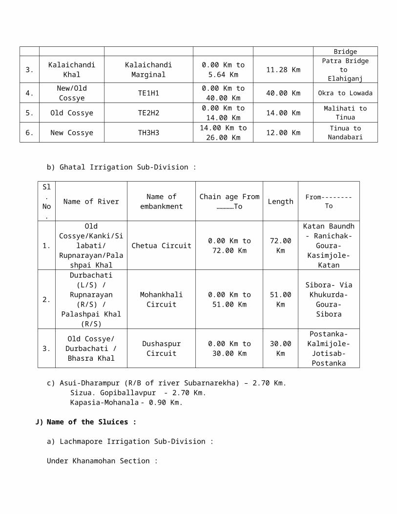
ii. The Block Livestock Dev. Officer (the Head of the Department of the Block and D.D.O.) has no bank account.
iii. The maximum post of U.D.C., L.D.C., Vety. Field Supervisor and Vety. Pharmacist under Block Livestock Dev. Officer are lying vacant.
3) Dealer of Feeds/Fodder Feeds : EPIC, West Bengal Dairy & Poultry Dev. Corporation, Salboni Feed Plant, Salboni, Paschim Medinipore. Ph. No. 9735736799 Fodder : Composite State Animal Husbandry Farm, Salboni, Paschim Medinipore.
4) List of cow sheds :
Not available
5) Site camps with volunteers:
There is no volunteers for site camp.
6) Programme for mass vaccination:
Sufficient vaccine available with the B.L.D.O. of the respective blocks, Programmes for vaccination will be taken within short notice.
7) Train the taskforce in respect of use of medicine : Block Livestock Dev. Officer, Vety. Officer, Pharmacist, LDAs and Prani Bandhus are there who are trained on use of medicine. So there is no necessity for further training of the taskforce in respect of use of medicine. District level, Sector level and Block level team were already formed in respect of animal health coverage.
6.16 ACTION PLAN OF AGRICULTURE
Paschim Medinipur District is located in the southern part of West Bengal between 22⁰57 10″ and′ 21⁰36 35″ North latitude and between 88⁰12 40″ and 86⁰33 50″ East longitude. The geographical area of the′ ′ ′ District is 929528 ha. It is bounded by Bankura District in Northern side; Hooghly in the North-Eastern side; Purba Medinipur District in the Eastern & South-Eastern side; Balasore & Mayurbhanj District of Orissa in the Southern side & Singbhum District of Jharkhand in the Western side.
The District comprises of 4 sub-divisions – Medinipur Sadar(6 Blocks), Kharagpur(10 Blocks), Jhargram(8 Blocks) & Ghatal(5 Blocks).
More than 80% of the total population lives in rural areas of the District & Economy depends on Integrated Agriculture & small scale industries.
The District possesses diversified ecosystem having different vegetation, soil types, climatology & geomorphology.
The important rivers like the Kangsabati, the Silabati, the Subarnarekha, the Dulang, the Tamal, the Keleghai & their tributaries flow through the District & enrich the cropping system by depositing fertile loam or sandy loam soil during rainy season.
The major crops grown in the District are Aus, Aman & Boro paddy, Wheat, Potato, Mustard, Til, Groundnut, Vegetables, Pulses, Watermelon, Maize, Sugarcane, Jute, Betel leaves, Matstick etc.
Net cropped area of the District is about 595210 ha. Having 153.34% cropping intensity. The District
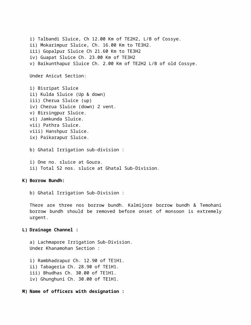
faces both flood & Drought & sometimes one is followed by another in a same year. Ghatal & a part of Kharagpur sub-division have flood prone areas of about 142647 ha. As well as Jhargram, Kharagpur & Medinipur Sadar sub-division have Drought prone area of about 335248 ha. The average rainfall of the District for last 25 years is 1538.0 mm. but it is the experience of the people that the District faces scattered & uneven distribution of rainfall almost in every year & the monsoon showers come always in late.
The Disaster Management plans in Agricultural sector means the contingent crop planning in Kharif crops during Kharif season to meet the unforeseen contingencies like flood, drought etc. during the growing season of crops.
Agriculture largely depends on nature & contingent crop planning is an integral part of agricultural production planning. The objective of the contingency crop planning is to provide ways & means to tackle the situation due to flood or drought or any other natural calamity.
To combat the situation whatever it may arise due to flood or drought the flowing action plan is to be adopted:
To overcome the adverse effect of Flood
Actions to be taken by farmers.1. Staggered sowing of paddy seed in seed bed at 10 days interval.2. A place of higher elevation to be choosen for raised seed bed.3. To reduce the detrimental effect of sand deposition in cultivated land, sufficient organic matter is to
be applied.4. If sand deposition is high, it is to be removed manually or mechanically.5. Where there is no time for rice cultivation-
a) Kalai(Variety-Sarada, Goutam, Sulata etc.) may be grown in the post-Kharif season.b) Toria, yellow sarson, lentil, gram, mustard & sunflower etc. may be grown early in the Rabi
season.To overcome the adverse effect of Drought
A. Actions to be taken by the departmental officers :a) Joint monitoring by District level officers of the department of Agriculture, Irrigation & Waterways
and WRI&D to be done to look into the real situation and to find out the ways for supplying Irrigation water from all Irrigation sources and ensuring it at grass root level in the blocks.
b) Water harvesting structures like pond, dugwell etc. to be excavated for storing rain water by various departments.
B. Actions to be taken by the farmers:
a) For harvesting rain or runoff water, earthen bunds are to be constructed around the individual plot.b) Application of organic manure to increase the water holding capacity of the soil.c) Community nursery seed bed of rice is to be done near a water source at least a month before
normal seed bed preparation.d) Staggered sowing of rice seed in seed bed at 10 days interval.e) Closer spacing with higher number of seedlings per hill are to be practiced.f) Direct seeding of rice through zero/minimal tillage machine.g) Cultivation of arhar, blackgram, groundnut & maize or mixed cropping of maize & arahar in high
lands.h) Mechanical weeding in rice field & use the uprooted biomass of weeds as soil mulch or use other
mulching materials like straw in rice field.i) Not to apply Nitrogenous fertilizer in the soil to restrict weed growth. Foliar spray of Urea or DAP @
1-2% may be applied at critical growth stages of the crop.
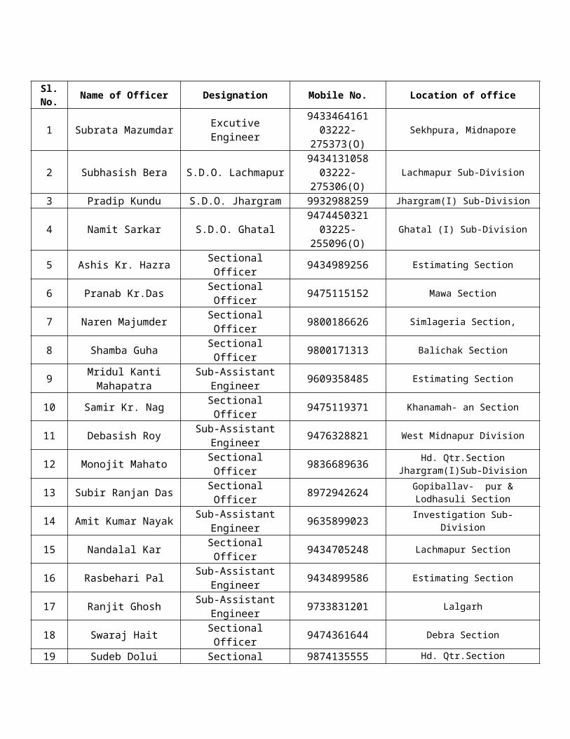
Measures to be taken by the Agriculture department through Govt. schemes:
A. Paddy: To keep the production of Aman paddy stable following steps will be taken-
1) Distribution of short duration paddy minikit(var-Kalyani-2, Sneha, Hira, Kshanika, Aditya, Purba, PNR-546, Kalinga-1, Annda etc.) among farmers.
No. of unit Seed/Unit Area to be covered(ha.)145000 10 Kg. 29000
2) Fertilizer as booster dose-No. of unit Fertilizer per unit Area to be covered(ha.)
300000 Urea 10 Kg., MOP 5 Kg. 40000
3) Growth regulator-No. of unit Growth regulator per unit Area to be covered(ha.)
100000 n-Tricontanol@50ml/phial 20000
4) Seed treating chemical-No. of unit Seed treating chemical per unit Area to be covered(ha.)
100000 Thiram/Tricyclazole75%WP@50gm./PKT 29000
5) Pest repellant-No. of unit Pest repellant per unit Area to be covered(ha.)
100000 Azadiractin10000ppm@500ml/phial 15000
6) Insecticide(for BPH & others)-No. of unit Insecticide per unit Area to be covered(ha.)
30000 Acephate@250gm/pkt 15000
B. Staggered seed bed at Govt. Farm & Farmers’ plot-
Place Seed/unit Area of seed bed(ha.) Area to be covered(ha.)Govt. Farm 50Kg. 12x5x50Kg.=6 ha. 60
Farmers’ plot 25Kg. 10000x25Kg.=500 ha. 5000
C. Storing of paddy straw in different Govt. Farms for cattle feed- 5 tonnes.
D. Rabi crops: To achieve the sustainable production of Rabi crops following Minikits will be distributed among the farmers.
i. Rape & MustardNo. of unit Seed/unit Fertilizers/Others/unit Area to be covered(ha.)
25000 B-54/Panchali: 3Kg. NPK102626@15Kg. 1000025000 B-9: 3Kg. NPK102626@15Kg. 10000
ii. KulthiNo. of unit Seed/unit Fertilizers/Others/unit Area to be covered(ha.)
125000 10Kg. R.Culture @ 400gm. 5000iii. Khesari
No. of unit Seed/unit Fertilizers/Others/unit Area to be covered(ha.)7500 Nirmal/Ratan: 12Kg. R.Culture @ 400gm. 1000
iv. WheatNo. of unit Seed/unit Fertilizers/Others/unit Area to be covered(ha.)

37500 PBW343/sonalika/UP262: 15Kg.
NPK102626@25Kg. 5000
v. PotatoNo. of unit Seed/unit Area to be covered(ha.)
75000 K-pokhraj: 300Kg. 1000075000 K-Jyoti: 300Kg. 10000
vi. GroundnutNo. of unit Seed/unit Fertilizers/Others/unit Area to be covered(ha.)
37500 AK-12-24/JL24: 15Kg. R.Culture @ 400gm. 5000vii. Boro Paddy
No. of unit Seed/unit Area to be covered(ha.)145000 10Kg. 29000
It is hopefully expected that the Department of Agriculture, Govt. of West Bengal will be in a position to tackle the situation due to disaster in the District of Paschim Medinipur like previous years.
6.17 ACTION PLAN OF AGRI-MECHANICAL DIVISION:
Midnapore (Agri- Mech) division, Paschim Medinipur is looking after the running and maintenance of 284 nos. Govt. owned and operated River Lift Irrigation Schemes and 169 nos. of Handed over River Lift Irrigation (RLI) Schemes. Out of this 284 nos. R.L.I Schemes, 84nos. are electrically operated and the remaining 200 nos. R.L.I Schemes are diesel operated. The Total cultivable command area of all these R.L.I Schemes is to the tune of 26,000 Ha (approximately) and the potential created due to installation of these schemes is approximately 60,000 Ha yearly.
As the discharge capacity of the diesel pump sets is reduced from the rated capacity due to their (20-25 years) ages resulting in less coverage of irrigation by the old and inefficient diesel pumping sets, the WRID Department started to convert all the diesel operated RLI Schemes to the electrically operated one. The proposed conversion/renovation of 1 no such diesel operated R.L.I Schemes will create an opportunity to bring back nearly 100-120% of the cultivable command area under assured irrigation. the conversion will facilitate easier operation and maintenance of the pumping sets, and will have beneficial effect on the environment besides avoidance of the hazards involved in the carriage & storage of highly inflammable H.S.D and lube oil required for the operation of diesel engine pumping sets. Existing Structures:- RLI Structures(Govt Owned) are as follows:-
Sl. No.
Type of structure Nos. Name of Block CCA in Ha Remarks
1 Major RLI 21 Midnapore Sadar 12602 Major RLI 7 Salboni 4203 Major RLI 8 Garbeta-I 4804 Major RLI 5 Garbeta-II 3005 Major RLI 3 Garbeta-III 1806 Major RLI 17 Keshpur 10207 Major RLI 16 Debra 9608 Major RLI 7 Khargpur-I 4209 Major RLI 7 Kharagpur-II 42010 Major RLI 7 Keshiary 42011 Major RLI 10 Narayangarh 60012 Major RLI 9 Sabong 54013 Major RLI 7 Dantan-I 42014 Major RLI 24 Jhargram 144015 Major RLI 26 Jamboni 156016 Major RLI 13 Binpur-I 78017 Major RLI 13 Binpur-II 78018 Major RLI 16 Gopiballavpur-I 96019 Major RLI 32 Gopiballavpur-II 1920

20 Major RLI 20 Sankrail 120021 Major RLI 16 Nayagram 960
RLI Structures (Handed Over) are as follows:-
Sl.No. Type of structure
Nos. Name of Block CCA in Ha RemarksMajor Midi Mini
1 RLI 9 6 4 Midnapur Sadar 8602 RLI 9 1 1 Keshpur 6003 RLI 4 2 0 Garbeta-1 3204 RLI 4 0 0 Garbeta-II 2405 RLI 2 0 0 Garhbeta- III 1206 RLI 12 1 0 Debra 7607 RLI 8 3 0 Salboni 6008 RLI 3 0 1 Kharagpur-I 2009 RLI 4 1 0 Kharagpur-II 28010 RLI 3 0 1 Narayangarh 20011 RLI 0 2 12 Sabong 28012 RLI 3 0 0 Keshiary 18013 RLI 1 3 3 Dantan-I 24014 RLI 4 3 0 Jhargram 36015 RLI 2 5 3 Jamboni 38016 RLI 2 2 0 Binpur-I 20017 RLI 1 6 2 Binpur-II 34018 RLI 6 4 4 Nayagram 60019 RLI 4 0 0 Sankrail 24020 RLI 1 4 3 Gopiballavpur-I 28021 RLI 7 3 0 Gopiballavpur-II 540
Ongoing Schemes:-
Sl.No. Type of structure
Nos. Name of Block CCA in Ha RemarksMajor Midi Mini
1 RLI 91 36 9 Different blocks of Paschim Midnapore except Ghatal S/Divn
7080
Plan for Management:-
1) As all the RLI Schemes(Govt. Owned ) are operated by the Operator cum Mechanic (OCM )/Assistant Operator(A.O.) who are posted in the above noted blocks under the BDOs of the District can be utilized for any disaster like situation.
2) The 4 nos. Assistant Engineer(AM)/(AE) of 4 nos. Sub Division and the Executive Engineer(AM) Midnapore(AM) Division can be contacted for the disaster management. Their Phone Nos. are as follows:-
Name of officer Designation Phone nos.Mr. Rupchand Murmu Assistant Engineer(AM) Jhargram-
I(AM) Sub Division03221 255163
Mr. Bibhas Jana Assistant Engineer(AM) Jhargram-II(AM) Sub Division
03221 255163
Mr. Kalyan Chakraborty Assistant Engineer(AM) Midnapore (AM) Sub Division
03222 275579
Mr. Debasih Ray Assistant Engineer(AE) 03221 275579
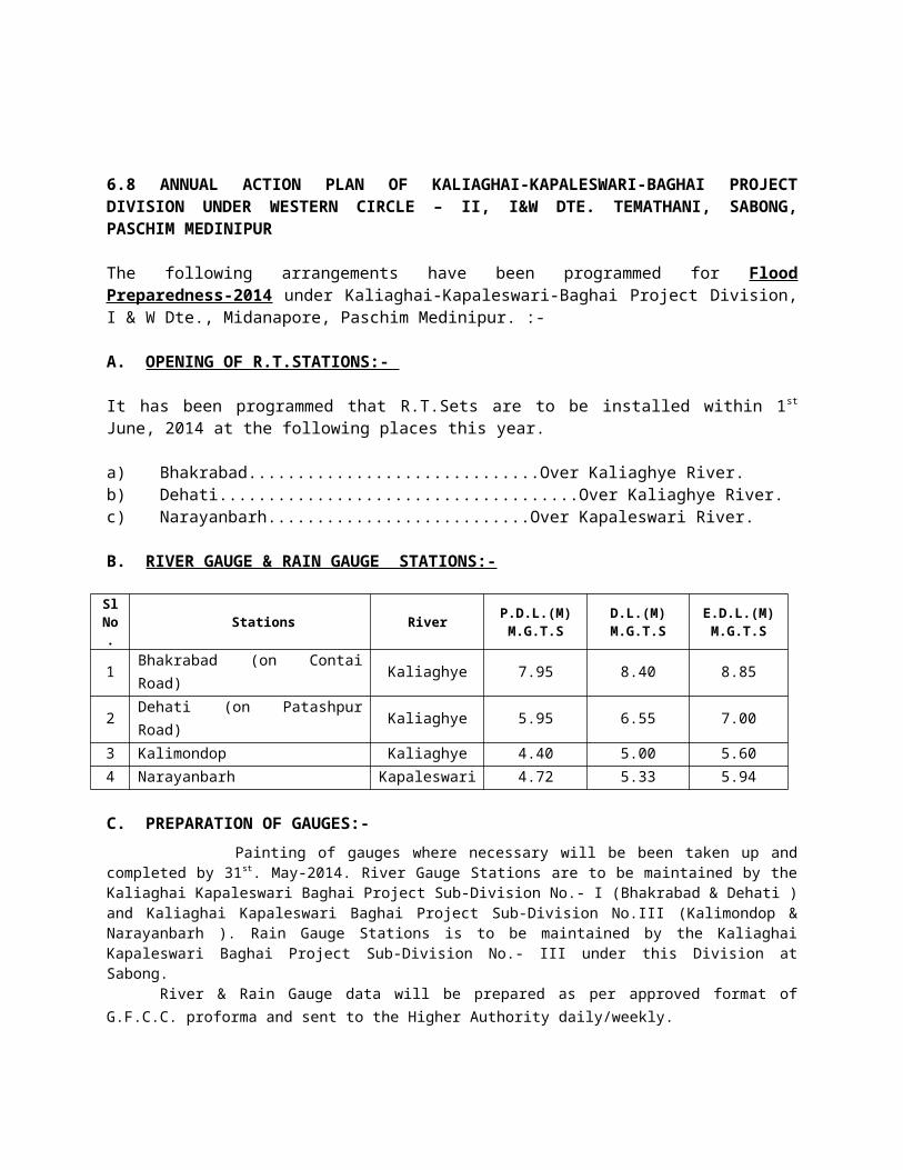
KharagpurI(AE) Sub DivisionMr. Naba Krishna Haldar Executive Engineer(AM)
Midnapore (AM) Division03222 275765/ (M)9830220128
6.18 ACTION PLAN OF AGRI-IRRIGATION
Minor Irrigation plays a vital role in the agricultural development of the state. Both surface as well as ground water are being harnessed for implementation of M.I.Schemes in various parts of state. However, surface water is more significant in those parts where ground water availability is less favourable.
A considerable number of Tube Well and surface flow irrigtation schems are in operation under Midnapore (A-I) division of water Resources Development Directorate. There are three sub-divisions under the division covering 16 (Sixteen) no. of blocks of Paschim Medinipur District. The Sub-divisional offices are located in Midnapore and Belda.Location of sub-Division offices:
1. Office of the Assistant Engineer (A-I) Midnapore (A-I) sub-division, Narampur (Near District Jugges’ Court), Post- Midnapore and Distt. Paschim Medinipur ph. No. 275465.
2. Office of the Assistant Engineer (A-I) Belda (A-I) Sub-division, Belda, Post- Belda, Dist. – Paschim Medinipur. Ph. No.03229-255264.
Sl. No.
Name Designation Contact details
1. Tapan Kumar Bhattacharjee Excutive Engineer, Agri-Irrigation, Paschim Medinipur
943432140603222-275465
2. Chandan Sarkar Asstt. Engineer, Belda (A-I) Sub-division
03229-255264
3. Goutam Banerjee Asstt. Engineer Midnapore (A-I) sub-division (officiating)
03222-275465
Measures to be taken for prevention of damages in Minor Irrigation Installations:-
1. Since most of the schemes are electrically operated, during pre-monsoon cyclone etc. necessary alertness to be ensured for causing temporary disconnection of power supply to the schemes to prevent loss of life by electrical short circuit etc.2. Pre-Monsoon cyclonic damages of command area should also be prevented which may ultimately cause damages to different spout chamber, Distribution chamber, existing Pipe line etc.
Details of Schemes:
Sl. No. Block Schemes installedDTW HDTW Total MDTW
1 2 3a 3b 3 (a+b) 3c1. Midnapur Sadar 4 4 62. Debra 3 3 6 13. Salboni - - - 64. Garbeta-I 6 - 6 115. Garhbeta-II 3 1 4 76. Garhbeta-III 1 - 1 97. Keshpur 11 6 17 128. Dantan-I 4 15 19 59. Dantan-II 4 7 11 510. Narayangarh 16 12 28 6
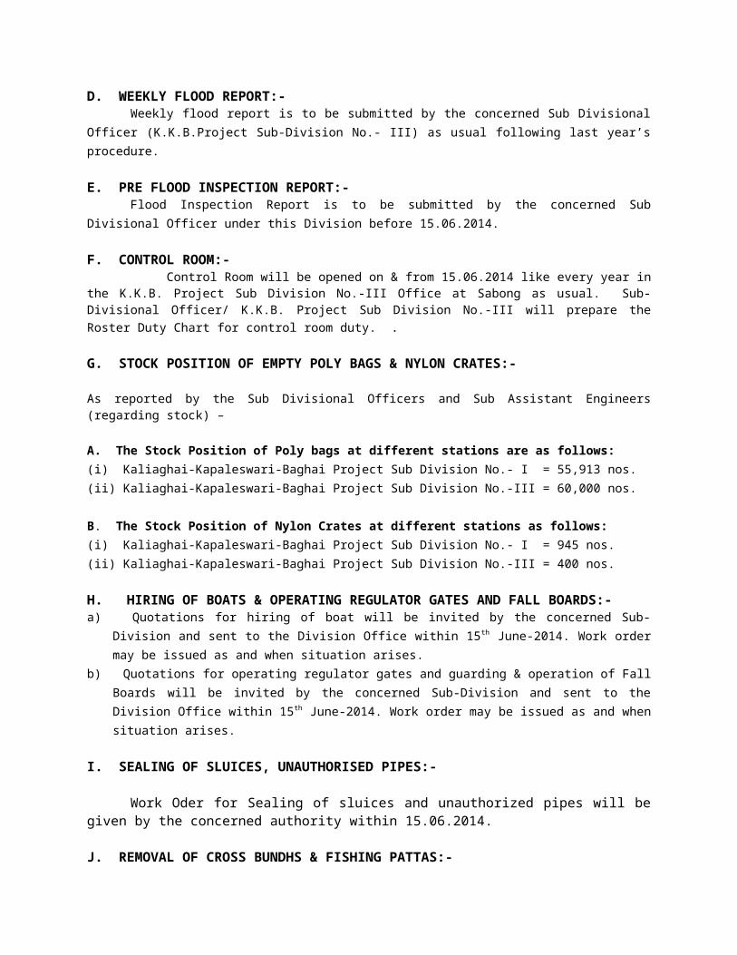
11. Mohanpur 3 7 10 412. Sabong 4 10 14 -13. Pingla 4 10 14 114. Keshiary 3 1 4 415. Kharagpur-I 4 - 4 216. Kharagpur-II 4 2 6 -Total 74 74 148 79
RIVER GAUGE STATIONS SHOWING PDL, DL & EDL ETC.[All figures are in Metric system with reference to GTS Datum (except Sl.22)]
Sl.No
Name of the Riverand Canal
Name of the GaugeStation P.D.L D.L. E.D.L. Highest level recorded
(Gauge Read) in Mtr.1 Rupnarayan Bandar (Ghatal) 6.24 6.85 7.46 9.47 28.9.782 Rupnarayan Ranichak (Daspur) 4.72 5.33 5.94 9.14 28.9.783 Rupnarayan Gopiganj (Daspur) 4.42 5.03 5.64 8.41 29.9.784 Silabati Banka (Ckona-II) 14.47 15.08 15.69 16.34 11.8.935 Silabati Gadighat(Ghatal) 8.88 8.99 9.60 11.12 2.9.786 Cossye Mohanpur(Kgp-I) 25.45 25.75 26.36 29.62 2.9.787 Cossye Kapastikri(Ksp) 15.39 16.00 16.61 17.88 2.9.788 Old Cossye Kalmijore(Daspur) 8.68 9.29 9.90 11.12 19999 Subarnarekha Dharampur Gopi 46.26 46.87 47.40 47.48 197310 Keleghai Bakhrabad 7.95 8.40 8.85 12.00 8.8.9911 Keleghai Dehati 5.95 6.95 7.00 9.00 15.9.0512 Kapaleswari Narayanbarh 4.72 5.33 5.94 6.83 23.10.0513 Keleghai Amgachia 5.18 5.79 6.4014 Keleghai Asnaghat 3.96 4.42 4.7215 Keleghai Kalimandap 4.40 5.00 5.33 4.99 24.10.0516 Chandia Barisha 4.11 4.57 5.0317 Subarnarekha Sonakonia 15.54 16.15 16.7618 Kangsabati Dam. 134.112 F.R.L. 132.88 132.92 134.11
Ground water schemes of this department are relevant for post flood restoration work during ‘Rabi season’ in the event of flood. 6.19 ACTION PLAN OF ENGINEERING DEPARTMENTS LIKE PWD (ROADS), PWD (NH) ETC.
Most of the roads under this division passes through the following less severe flood prone area like Jhargram, Binpur-I & II, Gopiballavpur I & II , Nayagram, Sankrail, Jamboni, Garbeta – I,II & III. At present the roads under this division are in trafficable condition. The comprehensive measures to repair the roads, where necessary, will be taken before ensuing monsoon.
Following contact No. with name of officer including roads under them has charged is mentioned.
Name Designation OfficePhone No. Mob. No. Road Length
(KM)A) Midnapore Highway Sub-Division No.-II
Sri Tapojjwal Mondal Asstt. Engr. 03222-266767 9474888972
Midnapore Town Central Bus Stand to Gope College road. 4.80Missing Link to N.L.Khan Road 1.75Sankrail-Kultikri Road 5.00Midnapore-Anandanagar-Chandra- Dheruaghat Road 24.30Manikpara-Dudhkundi-Sardia-Bombay Road. 9.00
Hatigeria-Kultikri-Rohini-Rogra Road 26.35
Manikpara-Khalsuli Road 10.00
B) Market Link Highway Sub-Division
Sri Kartick Ch. Das Asstt. Engr. 03222-268837 9932782205
Chandrakona-Goaltore-Seranga-Simlighat 29.00
Kalaberia-Pirakata-Dhansole-Lalgarh 35.00
Keshpur-Anandapur 6.50Garbeta-Hoomgarh 13.00Lalgarh-Ramgarh 15.00Ramgarh-Pingboni 6.70Garbeta-C.K.Town(Via Raskundu) 22.40
C) Jhargram Highway Sub-Division
Sri Krishnendu Guha Majumdar Asstt. Engr. 03221-255069 9433164617
Dahijuri-Binpur-Silda-Hatiari 31.50Lodhasuli-Rogra 20.70Sevayatan-Baita-Dheruaghat 7.00Gopiballavpur-Fekoghat 12.00Gopiballavpur-Nayagram 42.00Kharikamathani-Dhumsai 20.00Gopiballavpur-Hatibari 20.00Parihati-Jamboni-Fekoghat 26.40Jhargram-Jamboni 11.20Link road between J.J.& P.J.F. 3.00Dubrajpur-Pukuria 4.40Belpahari-Banspahari 23.80Dharsa-Belpahari 16.30Narayanpur-Silda 2.15
6.20 ACTION PLAN OF CIVIL DEFENCE DEPARTMENT
1. No. of Civil Defence Volunteers / Trained CD personnel of different Blocks / Municpalities under Paschim Medinipur District :
Sl. No. Name of the Blocks / Municiapality
Name of CD Volunters / Traned CD Personnel
1. Debra 992. Pingla 713 Sabong 784. Dantan-I 215. Dnatan-II 426. Mohanpur 417. Daspur-I 208. Nayagram 259. Kharagpur-I 242
10. Kahragpur-II 1311. Narayangarh 2212. Keshiary 3713. Jhargram Municipality 2514. Ghatal Municipality 2415. Midnapore Sadar Block 14
Total 774
2. Boats which may be hired in different Blocks / Sub-Divison under Paschim Medinipur District :
Sl. No. Name of Sub-Division / Block FRB OBM
1. S.D.O. Ghatal 01 012. Daspur-I Block 01 01

3. Sabong Block 02 024. Pingla Block 02 025. Narayangarh Block 02 026. Sankrail Block 01 017. Gopiballavpur-I Block 01 018. Midnapur Sadar Block 01 01
Total 11 Nos. 11 Nos.9. Civil Defence 4 no. inflatable Rubber Boat


