+ All Categories
Home > Documents > Weather routeing: minimising the risk of containers overboard

Weather routeing: minimising the risk of containers overboard

Date post: 21-Nov-2021
Category:
Upload: others
View: 3 times
Download: 0 times
Share this document with a friend
42
Weather routeing: minimising the risk of containers overboard 2 September 2021 • 09:00-10:30 BST Part of Container Ship Tech & Ops Webinar Week 2-3 September 2021 Panellist documents Page 2: Alexander Ozersky, Intellectual Systems, Wärtsilä Page 12: Carlos Freire, COBS-Container Overboard System Page 21: Henry Chen, B2B7CS, LLC Page 36: Jouni Salo, Unikie
Transcript

Weather routeing: minimising the risk of containers overboard2 September 2021 • 09:00-10:30 BST

Part ofContainer Ship

Tech & Ops Webinar Week

2-3 September 2021

Panellist documents

Page 2: Alexander Ozersky, Intellectual Systems, WärtsiläPage 12: Carlos Freire, COBS-Container Overboard SystemPage 21: Henry Chen, B2B7CS, LLCPage 36: Jouni Salo, Unikie

© Wärtsilä PUBLIC

WEATHER ROUTEING:PREVENTING LOSSOF CONTAINERSALEXANDER OZERSKY

© Wärtsilä PUBLIC August 2021 Weather routeing: preventing loss of containers2

WÄRTSILÄ VOYAGEFrom unconnected traditional sails to data-driven intelligent ships and ports

that make voyages safer, greener and more efficient: Wärtsilä Voyage is on a

mission to build a Smart Marine Ecosystem. We combine hard- and software

solutions to optimise the entire lifecycle of marine operations. Our technology

is futuristic, but it is targeted to solve today’s shipping challenges. Be it energy

efficiency, operational efficacy, decarbonisation or navigational safety – we are

constantly researching, developing and investing in a wide range of products

and solutions that help our partners and clients achieve their goals in every

part of the world and oceans. With over 100 years of experience and one the

broadest portfolio in the market, we are ready to build the future.

TECHNOLOGY SOLUTIONS.

FOR A SAFER, GREENER AND MORE EFFICIENT MARINE INDUSTRY.

© Wärtsilä PUBLIC August 2021 Weather routeing: preventing loss of containers3

Planning

and loadingExecution

Post-voyage

analysis

Re-planning

Long-term

actions

© Wärtsilä PUBLIC August 2021 Weather routeing: preventing loss of containers4

ANATOMY OF AN INCIDENT

Training Tools Policies and procedures Planning Operation

INCIDENT

E R R O R S

© Wärtsilä PUBLIC August 2021 Weather routeing: preventing loss of containers5

WEATHER ROUTING IN FLEET OPERATIONS SOLUTION (FOS)

© Wärtsilä PUBLIC August 2021 Weather routeing: preventing loss of containers6

TRACKING AND AWARENESS MODULE IN FOS

© Wärtsilä PUBLIC August 2021 Weather routeing: preventing loss of containers7

SIMULATION MODULE

© Wärtsilä PUBLIC August 2021 Weather routeing: preventing loss of containers8

Voyage planning and execution

is continuous and multi-role activity

Weather routing is needed before,

during and after the voyage

Good tools provide more layers

of defense against incidents

© Wärtsilä PUBLIC August 2021 Weather routeing: preventing loss of containers9

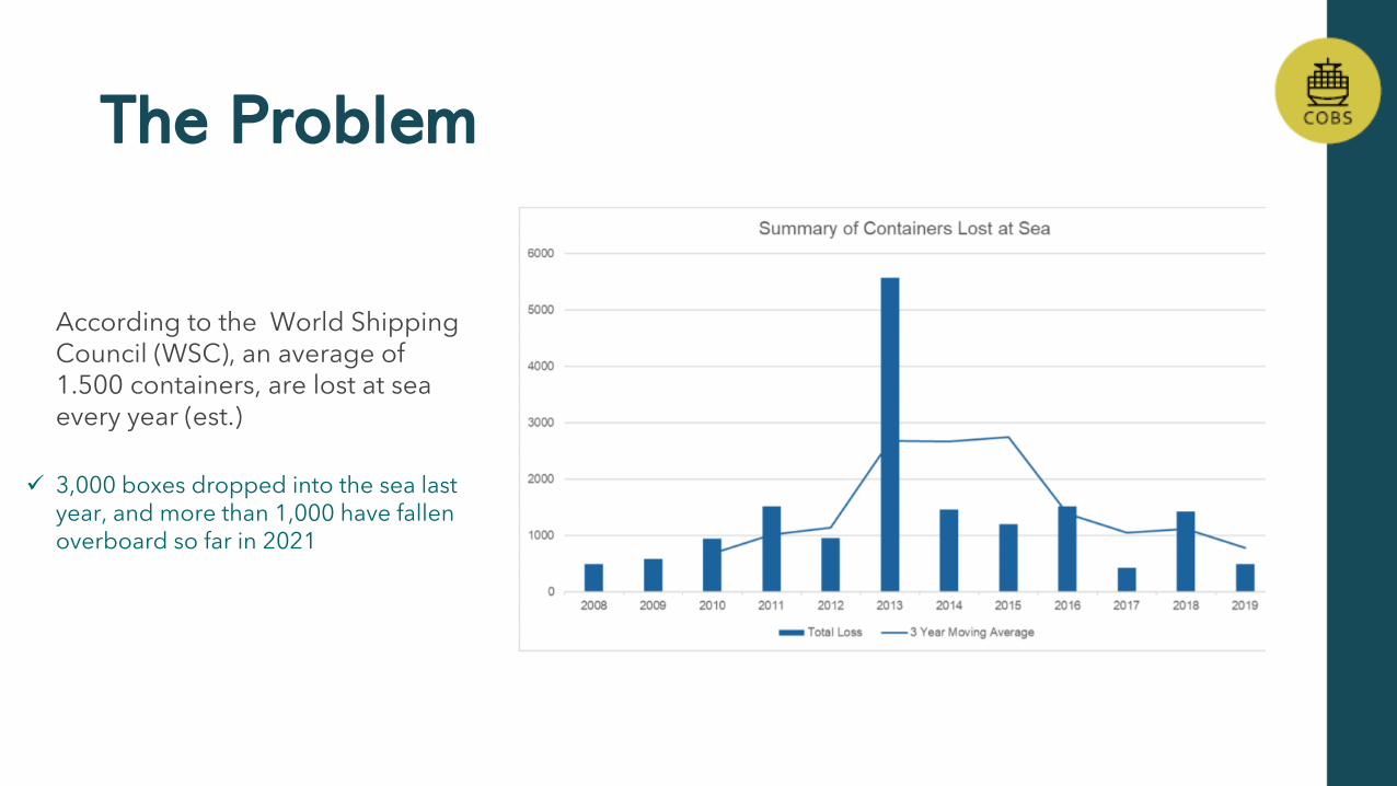
According to the World Shipping Council (WSC), an average of 1.500 containers, are lost at sea every year (est.)

✓ 3,000 boxes dropped into the sea last year, and more than 1,000 have fallen overboard so far in 2021

The Problem

The Problem

➢ Supply Chain

➢ Navigation Safety

➢ Environmental

Loss of containers does not only affect shipowners, but many other stakeholders in the supply chain, creating a web of mixed liabilities

Floating containers represent a collision risk forvessels, as they tend to float right beneath the surfaceof the sea.

Losing a single container may seem ‘harmless.However, when hundreds (if not thousands) breakapart or start to sink, they become a significant sourceof pollution for deep-sea ecosystems

Improper loading and unloading of containers: wrong lashing equipment, misuse or unsuitability of twist-locks, poor quality of the container itself…

Non-compliance with international conventions, container guidelines and practice standards, such as the ship’s Cargo Securing Manual (CSM) or the stowage plan

Failure to accurately declare the container’s weight (VGM), whether it comes from grounds of negligence or wilful misconduct, resulting in incorrect stowage

Improper stuffing of goods inside containers, causing them to shift during transport and destabilize the vessel

Extreme weather conditions can worsen the ship’s parametric rolling and pitching, thereby increasing the likelihood of containers falling overboard

Why do containers fall overboard?

ULCS upright equilibrium position period vs wave period, resulting in rolling resonance, causing extreme heeling angles combined with high accelerations and forces due to high ship stability.

Heave within swallow waters, so ULCSs can touch seabed, causinghigh shocks and vibrations.

Breaking waves hitting the side of the ship, resulting in waterjets reaching the containers that can lead to substantial damage to different elements and pushing the containers stacks.

ULCS MSC Zoe extreme weather case study

Route Shipping Planning

✓ Preliminary route in the planning

✓ Optimum speed recommendations (RTA)

✓ Aprox. Fuel consumption

✓ Fast and then slow it down when RTA

✓ AIS tracking

✓ Optimum routes based on requirements

TRADITIONAL-REACTIVETODAY´S – PROACTIVE AND PREDICTIVE

FUTURE

✓ Weather forecast to build optimal routes

✓ Safely and in time, RTA or constant speed

✓ Frequently updates (data and route)

✓ More integrated with vessel performance and onboard data

✓ Automatically provide several recommended routes

✓ Energy efficiency and emission reduction

Sailing Technologies

Can Weather Routing minimize the risk of container losses?

Plenty of blames to go around

• Global warming causing more severe and unpredictable

storms in the ocean

• Class societies relaxed design criteria too much for those

Ultra Large container ship because of their size

• Shipyards “optimizes their designs” in order to minimize

the building cost

• Containers not properly lashed due to tight schedule

• Ship crews lack experience in operating this class of

ships

• Weather routing companies not doing their job

3

Enabling technologies that can be utilized

for improving ship safety and efficiencies

1940 1950 1960 1970 1980 1990 2000 2010

D-Day Landing Weather Briefing Super Computer

weather forecast

Powerful PC

Low cost sensor

Satellite Communication

Satellite AIS tracking Cloud Computing

CFD modelling

Fax weather map

Ship Motion Theory NWPS and WAM models

Ensemble Forecast

For wind and waves Hi-Res Current + Sea

surface temp. Model

Resonance

Diagrams

Seakeeing

Guidance

System Telex Routing

advisory

Electronic Charts Weather Routing

Voyage

Optimization

MEM Sensor

Advances in hurricane prediction

Richard B. Alley et al. Science 2019;363:342-344

Copyright © 2019, American Association for the Advancement of Science

A total of 7 incidents and 3079 containers lost

during the past winter in Pacific Ocean

Jeppesen Proprietary - Copyright © 2015 Jeppesen. All rights reserved.

Incident Size Build Year Port Rotation Date Location of Accident

Impact: Containers

Lost

Number 1 14000 TEU 2018

Eastbound:

China - Long Beach Oct 30, 2020

"in vicinity 40 00N 178 10E in

the morning Oct 30" 100

Number 2 14000 TEU 2019

Eastbound:

China - Long Beach Nov 30, 2020 "1,600nm NW of Hawaii" 1816

Number 3 8452 TEU 2014

Eastbound:

S. Korea - Los Angeles Dec 31, 2020

"20nm off the cost of Kyushu,

Japan" 36

Number 4 8204 TEU 2006

Eastbound:

S. Korea - Vancouver Jan 2, 2021 NW Pacific 76

Number 5 13100 TEU 2010

Eastbound:

N. China - Los Angeles Jan 16, 2021

N of Hawaii,

approximately 30N155W 750

Number 6 14300 TEU 2020

Westbound:

Long Beach - China Jan 26, 2021

SE of Japan, approximately

25N165E 41

Number 7 13100 TEU 2010

Eastbound:

China - Los Angeles Feb 17, 2021 "45nm off Northern Japan" 260

Courtesy of Weathernews Inc.

What can we learn from past incidents?

Jeppesen Proprietary - Copyright © 2015 Jeppesen. All rights reserved.

• Most incidents occurred at night. Crew only found the extent of damage caused by

excessive roll or boarding waves next morning

• The wave conditions were severe (up to 6-7 meter Sig Height), but ships had

experienced worse weather before

• Most likely cause of the damage was large roll angles and accelerations due to

Synchronous or Parametric roll resonance, resulting lashing failures

• Severe motions can also cause propeller racing, tripping the engine and lost of power

• Weather routing service providers and onboard software were not able to predict such

risks and re-route the ship or advise the captain

• Crew were not trained to make tactical maneuvers to reduce the motions when

resonance started to occur

Ship motion predictions were established decades ago

• Ship motion theory has been well established and widely used

by Classification Societies and ship designers

• Algorithm takes hull geometry, actual drafts and GM into

account when predicting ship motions

• Responses includes roll & pitch angles, accelerations,

slamming, deck submergence, and propeller racing

• Parametric roll and tank sloshing predictions are based on the

computed response periods and angles using three wave trains

(sea and swells)

8

Seakeeping Guidance Polar Diagram vs. Resonance Diagram

Seakeeping polar diagram provides guidance on

speed/heading to be within specified safe

operating limits

Allows user to see at a glance speed /

heading combinations that would not

exceed safe operating limits

Automatic and on-demand

Provides a quick reference to maneuver

ship to safer and more efficient state

Captain may define Safe Operating

Envelope

Linked to GPS and wave forecasts

Optional multi-axis solid-state motion

sensor

9

IMO recommended

Resonance diagram Offers

general guidance on a

range of speed and

heading without predicting

amplitude or period of the

motions

Cargo Safety at Sea is a concerted effort by all parties

Ship Owners/Managers

• Insist on safety measures in selecting class/builder and service

provider

• Invest into digitization of operations and shore-side decision support

centers

• Improve crew training

• Reduce crew workload by replacing manual reporting tasks with

automate monitoring system

• Eliminate silos with competing KPIs in ship management metrics

• Incentivize safety culture in all aspects of ship operations

Cargo Safety at Sea is a concerted effort by all parties

Ship Operators

• Work as a team with weather routing companies in seeking advice on

latest forecast of storm movements

• Embrace digitization and learn new computer skills

• Understand and support safety culture with continual online training

courses in navigation and ship handling

• Rely on sensors when one cannot “feel in the leg” due to the sheer

size of the ultra large ships

• Utilize digital technology for organizing daily routines and managing

time

• Work as a team with shore-side management on voyage optimization

Cargo Safety at Sea is a concerted effort by all parties

Jeppesen Proprietary - Copyright © 2015 Jeppesen. All rights reserved.

Class Societies and Shipbuilders

• Learn from past accidents and improve design criteria especially for

those new, ultra large ship types with relatively short operating history

• Make the design transparent and document features that can affect

the safety of cargo and ship structure.

• Create a centralized shipboard as well as shoreside depository of

operational data for helping accident investigation and create an early

warning systems using AI and DL techniques

• Assist in create/validate ship response/seakeeping models

Cargo Safety at Sea is a concerted effort by all parties

Port Authorities

• Provide an open platform/website and free WIFI connection to ships

in port as well as anchoring areas for exchange of information

• Update of port congestion conditions on the website

• Update weather current conditions in port as well as anchoring areas

• Use AI to estimate loading/unloading times for planning port

schedules

• Ensure proper container lashing rules taking into consideration of

forecast storm conditions.

Cargo Safety at Sea is a concerted effort by all parties

Jeppesen Proprietary - Copyright © 2015 Jeppesen. All rights reserved.

Weather Routing Companies

• Understand the ultimate goal is to advise captain on how to arrive at

the destination without damage to ship, cargo and crew within the safety

envelop

• True voyage optimization needs to use seakeeping and propulsion

models (Digital Twin) to accurately predict the ship performance using

the latest wind/wave/current forecast

• The ship seakeeping model should be able to predict motions and

deck submergence, propeller emergence etc. for the specified drafts

and GM.

• Utilize Ensemble Forecast to predict probability of exceeding safety

envelop and quantify the uncertainties of fuel consumption, arrival time

for better route selection.

Ship

Maneuvering

Model

Ship

Propulsion

Model

Ship Operations Digital Twins

Big Data

Other data

sources:

•Noon Reports

•Design Data

•Trial Data

Neural Network

Environment

and Chart

databases

Ship IoT Box

6D Motion

AIS

•Collision Avoidance

•Docking Assistant

•Autopilot/ECDIS

•Charter party performance

•ETA for port operations

•Ship deployment scheduling

•Optimum Ship Routing

•Fleet Performance monitor

•Efficiency/safety optimization

Shipboard

Sensors

Ship motion

Seakeeping

Model

In conclusion:

“Given the right tools, the future of weather routing as a

decision support service can minimize container losses

while reducing fuel consumption and arrive on-time”

For further detailed explanations, please read my articles posted on Linkedin:

“Art and Science of Ship Voyage Optimization – A Critical Review “

Thank you for your attention

Henry Chen, Ph.D.

Streamlined operations - one interface of secure information flow between vessels and all port actors

PORT FLOWOPTIMIZATION

Jouni SaloDirector, Business [email protected]

MISSION

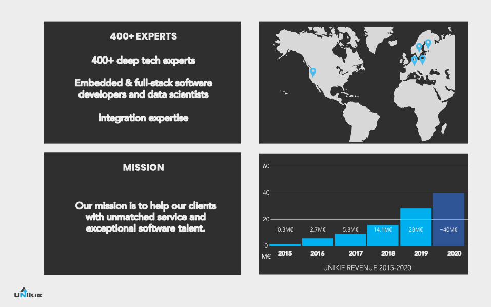
Our mission is to help our clientswith unmatched service and exceptional software talent.

400+ EXPERTS

400+ deep tech experts

Embedded & full-stack software developers and data scientists

Integration expertise

2015 2016 2017 2018 2019

2.7M€0.3M€ 5.8M€ 14.1M€ 28M€

2020

~40M€

M€0

20

40

60

UNIKIE REVENUE 2015-2020

OUR CLIENTS

Intelligent Systems, Telecom, Secure Connectivity

Information and Web TechnologyIntelligent Machines,Industrial Systems

Automotive & Mobility

UNIKIE – Smart Port Solutions

Port Flow Optimization tool

Framework for data sharing, enhanced collaboration, and joint situational awareness

Port Digitalization and Automation

Automated and Autonomous operations

Machine Vision based autonomous driving and dynamic safety zone solutions for port machines

Port staff and dockworker management tool

Hands-On tool for organizing and managing the staffing in ports

Securing integrated systems and processes

Monitoring and securing system for integrated IT systems and processes

POLO AI Vision Staffer Aino.io

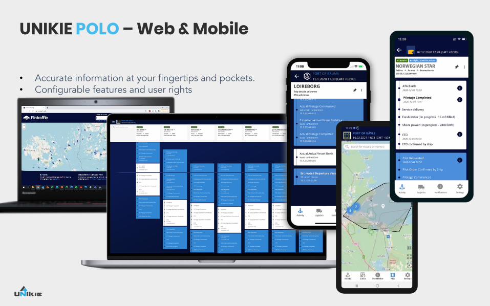
UNIKIE POLO – Web & Mobile

• Accurate information at your fingertips and pockets.• Configurable features and user rights

FAST EVOLVING OPEN PLATFORM – FROM PORTS TO PORTS

Development started in 4.5Meur Central Baltic Efficient Flow Project:

IALA S-211 compliant

New development requirements 100% directly from ports – New features available for all users

Func

tiona

lfe

atur

esC

omm

unic

atio

nfe

atur

esAI based info features

Port Call Process

Port O

perat

ions

Hinterl

and O

perat

ions

Business Process

Situational AwarenessFeatures (Integrations)

POLO

UNIKIE.COM

YOU!THANKUnikie Finland Unikie GmbH Unikie Ab Unikie Inc. Hermia 11 In der alten Hutfabrik Theres Svensson gata 13 470 Ramona Street, PMBHermiankatu 1 Langhansstrasse 93 41755 Göteborg Palo Alto CA 94301-170733720 Tampere 13086 Berlin Sweden United StatesFinland Germany


Recommended