Web-based Cadastral Information System for Land Management Israel TAIWO, Olasunni DARAMOLA, Godwill Tamunobiekiri PEPPLE, Nigeria Key words: Cadastral, Web, Land, Management SUMMARY Data and information (Cadastre inclusive) about land, land use and land ownership are scattered among different actors. The managers and resources necessary for the management of such data and information are distributed across several professionals, and the various users of the above lies at different locations. Web technology has become an important technology in attaining and ensuring better interoperability, accessibility and scalability on a large scale. Leveraging the potentials of the web with cadastral information management is the purpose of this research. This work describes a research and analysis into the current cadastral information management process of Ekiti State, Nigeria. A web-based prototype of the above was proposed, designed and developed as a modification to the existing system. The development of the prototype was guided by the research conducted into the choice of system, software and required functionalities for the proposed “Web-based Cadastral Information System”. During the research, it was discovered that while 73.68% of public users prefer the use of web browsers to access cadastral information, 71.43% of professional users prefer the use of a web enabled application. While 41% of professional users like to access information about land on the web, only 2.56% will like to interact with their clients using the web. The overall result of the process describes the indispensability of web-based cadastral information management system in ensuring a much more informative and users’ participatory cadastral information system for land management. Opportunities for further research, such as; building web-based tools with less intensive internet connectivity, developing or contributing to existing Web-enabled applications for land management by Professionals was identified.
Transcript
Web-based Cadastral Information System for Land Management
Israel TAIWO, Olasunni DARAMOLA, Godwill Tamunobiekiri PEPPLE, Nigeria
Key words: Cadastral, Web, Land, Management
SUMMARY
Data and information (Cadastre inclusive) about land, land use and land ownership are scattered
among different actors. The managers and resources necessary for the management of such data
and information are distributed across several professionals, and the various users of the above lies
at different locations. Web technology has become an important technology in attaining and
ensuring better interoperability, accessibility and scalability on a large scale. Leveraging the
potentials of the web with cadastral information management is the purpose of this research. This
work describes a research and analysis into the current cadastral information management process
of Ekiti State, Nigeria. A web-based prototype of the above was proposed, designed and developed
as a modification to the existing system. The development of the prototype was guided by the
research conducted into the choice of system, software and required functionalities for the proposed
“Web-based Cadastral Information System”. During the research, it was discovered that while
73.68% of public users prefer the use of web browsers to access cadastral information, 71.43% of
professional users prefer the use of a web enabled application. While 41% of professional users
like to access information about land on the web, only 2.56% will like to interact with their clients
using the web. The overall result of the process describes the indispensability of web-based
cadastral information management system in ensuring a much more informative and users’
participatory cadastral information system for land management. Opportunities for further research,
such as; building web-based tools with less intensive internet connectivity, developing or
contributing to existing Web-enabled applications for land management by Professionals was
identified.
Web-based Cadastral Information System for Land ManagementManagement (8035)
Israel Taiwo, Oladunni Daramola and Godwill Tamunobiekiri Peppe (Nigeria)
FIG Working Week 2016
Recovery from Disaster
Christchurch, New Zealand, May 2–6, 2016
Web-based Cadastral Information System for Land Management
Israel TAIWO, Olasunni DARAMOLA, Godwill Tamunobiekiri PEPPLE, Nigeria
1. INTRODUCTION
Land is a non-increasing factor of production that houses an increasing population. A great
percentage of man’s activities depend on land. The quests for land ownership, registration, transfer
of ownership etc., are concepts that affect land management. Estimations show that about 70% of
people – land relationships worldwide are not documented, whereas, population grows and the
pressure on land and natural resources increases. Oftentimes, the poor suffer most. These result in
many land conflicts and competing claims on land. (Kadaster Abroad, 2014). Even the documented
30% have to be “re-documented” due to technological changes and new user demands. Hence, the
saying that man is never done administering land.
Data and Information regarding land acquisition, adjudication, demarcation, and transfer are
significant to the effective management of land. In Nigeria, the land Surveyors are known to be the
custodian of land data and information. Other actors involved in the interest to land includes the
town planners, the lawyers, security agents, the office of the surveyors’ general and the Governor of
the state who confers the right to land ownership on an individual or group of individuals. The
process of gaining right to land; which require passing through all of these actors, is a long process
that is termed frustrating by some.
In securing land rights for the world, United Nations Global Geospatial Information Management
(UN GGIM) formulated some global needs, Food and Agricultural Organisations of the United
Nations developed Voluntary Guidelines, and the World Bank monitors good practices in the land
sector with a Land Governance Assessment Framework (LGAF). Together with the International
Federation of Surveyors (FIG), they promote Fit for Purpose Land Administration approaches
(Kadaster Abroad, 2014). According to LGAF, focusing only on specific aspects such as land
administration or surveying may not only miss important synergies to other parts of the system but,
in the end also prove to be ineffective and unsustainable, hence, the need to consider the concept of
cadastre and land management in relation to computer science.
The massive network of networks that connects millions of computers (Fu & Sun 2011) known as
the internet has become an effective tool in information sharing, collaboration and interoperability.
Harnessing the potentials of Geographic Information Systems (GIS) with that of the internet has led
to the development of the concept of Web GIS; which has led to a transformation in the world of
Geoinformatics by enabling problem solving with the full functionality of the internet. Web
technologies are deployed on desktop computers and as well on mobile devices. The internet offers
Web based information systems a robust platform for data and information processing, data storage
and consequently a performance that supersedes its non-web based desktop and mobile
counterparts.
Accessibility and interoperability are part of the comparative advantages of Web based information
systems. The “scalability” from one or more users to millions of internet users rendered by well
Web-based Cadastral Information System for Land ManagementManagement (8035)
Israel Taiwo, Oladunni Daramola and Godwill Tamunobiekiri Peppe (Nigeria)
FIG Working Week 2016
Recovery from Disaster
Christchurch, New Zealand, May 2–6, 2016
configured Web systems is an advantage. Data used by various users can be utilized by several
other users, whereby reducing redundancies and promoting usability. These are pros of web based
systems among others yet to be discovered or developed.
The web has transformed the way many things are done these days. Hence, this paper discusses
the methodology and results obtained from the prototye designed to harness the potentials of web
technology with the existing framework for cadastre administration, using Ekiti State as a case
study, so as to engage the challenges of Land administration and enhance the relevance of Land
Management, Cadastral Information System (CIS) and web-based technologies to produce a
synergy of the trio.
2. LITERATURE REVIEW
a. The Cadastral Concept
The non-increasing nature of land has raised many questions in the heart of researchers, and this
among other factors has led to the exploration of other planets in an attempt to discover their
adaptability for man and its environment. The limited quantity of land among other factors
contributes significantly to land disputes among persons, states, countries and even continents,
especially at their urban centres. The ownership of land, its tenure of ownership, precise and
accurate location and the its value are
Land parcel is the basic unit for access and control of land, as well as land use decisions. Current
and reliable land information is necessary for many public programs, for land planning, and for
infrastructure development. (Babawuro, 2010). Cadastre systems include the interaction between
the identification of land parcels, the registration of land rights, the valuation and taxation of land
and property, and the present and possible future land use (Enemark, 2005). The relationship
between Land, People and Rights, Responsibilities and Restriction is one that varies significantly
from place to place. Cadastre is the product of Land Registration exercise. The word Cadastre is
often confused with Land registration as it is defined as “a record of interests in land encompassing
both the nature and extent of those interests”, whereas Land Registration has been defined as “the
official, systematic process of managing information about land tenure” (Nichols, 1993). Hence
Land Registration is the process, while Cadastre is the product. The effective management of the
two in solving and resolving issues such as Land Ownership, Occupancy, Tenure, Transfer and Use
rights is the term referred to as Land Management in this project.
There are three categories of cadastre, namely; juridical cadastre, fiscal cadastre and multipurpose
cadastre. Juridical cadastre is a legally recognized record of land tenure as well as a register of
ownership of land parcel. Fiscal cadastre is developed primarily for property valuation; it is a
register of properties recording their value. Multipurpose cadastre encompasses both parcel related
information, and is as well a register of attributes of parcels of land (Dale, 1976; Dale and
McLaughlin, 1988).
Land Administration encompasses aspects such as, Cadastral Survey, Mapping, Land Registration,
Land Information Systems, Legal, Fiscal and Multipurpose Cadastre. The term is defined as “the
process of determining, recording and disseminating information about the tenure, value and use of
land when implementing management land policies” (Tan & Looi, 2013). In Nigeria, a cadastre is
the product of a cadastral survey exercise conducted by a land surveyor for the purpose of
Web-based Cadastral Information System for Land ManagementManagement (8035)
Israel Taiwo, Oladunni Daramola and Godwill Tamunobiekiri Peppe (Nigeria)
FIG Working Week 2016
Recovery from Disaster
Christchurch, New Zealand, May 2–6, 2016
determining the location, size, and obtaining description of a land parcel with reference to a
geographic framework. Often times the cadastre is used for securing legal rights to land, but the
fiscal ability of cadastre are not maximized.
Figure 1: The Cadastral Concept(Source: CADASTRE 2014 and Beyond)
b. Web based Systems
The advent of the Internet and the Web are great milestones in the evolution of human civilization
(Fu & Sun, 2003). The Web brings database information to the world (Bra, 2003). Web-based
information Systems have also grown rapidly in scope and extent of use, significantly affecting all
aspects of our lives. Industries such as manufacturing, travel and tourism, banking, education, and
government are Web-enabled to improve and enhance their operations (Worwa, 2010). In recent
years, the Internet and World Wide Web (www) have become ubiquitous, surpassing all other
technological developments in our history. In web based systems, the user interacts with the web
server from the web interface with websites by using a web application. In recent times, the web
Web-based Cadastral Information System for Land ManagementManagement (8035)
Israel Taiwo, Oladunni Daramola and Godwill Tamunobiekiri Peppe (Nigeria)
FIG Working Week 2016
Recovery from Disaster
Christchurch, New Zealand, May 2–6, 2016
server is linked with a database server that manages the data and reduces the workload of the web
server for optimal use.
Figure 2: Basic Web Architecture
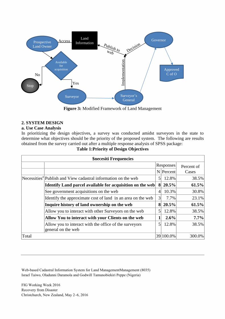
c. Modified Framework for Land Management
In the existing framework for land management in Ekiti State, procurers of rights to land have
limited information about the status of land. They purchase the land, then meet with a land
surveyor to carry out the cadastral survey of the area. The surveyed plan is taking to the Surveyor’s
General (SG) of the state who then inspect, chart and check the parcel against polygons of prior
acquisitions. If the parcel does not fall within any prior acquisition, the SG then gives an “SG
approval” which is used in processing the Certificate of Occupancy (C of O) to the Land. When
such surveys fall within a prior acquisition; dispute is created, and its accruing circumstances are
often devastating.
The proposed system is to provide a web based interface where information about land could be
published and accessed by the respective users prior to procurement. Such information about land
includes the ownership status, prior acquisitions, availability for sales etc., Accessing land
information on the web will be carried out by prospective owners of right to land before procuring
the portion, incurring expenses on the survey plan and before requesting for an SG approval.
Information about land will be published by the Office of the Surveyor’s General of the state on
timely basis and owners of rights to the land could access and share this information anywhere at
any time using the web-based system.
Web-based Cadastral Information System for Land ManagementManagement (8035)
Israel Taiwo, Oladunni Daramola and Godwill Tamunobiekiri Peppe (Nigeria)
FIG Working Week 2016
Recovery from Disaster
Christchurch, New Zealand, May 2–6, 2016
Figure 3: Modified Framework of Land Management
2. SYSTEM DESIGN
a. Use Case Analysis
In prioritizing the design objectives, a survey was conducted amidst surveyors in the state to
determine what objectives should be the priority of the proposed system. The following are results
obtained from the survey carried out after a multiple response analysis of SPSS package:
Table 1:Priority of Design Objectives
$necesiti Frequencies
Responses Percent of
Cases N Percent
Necessitiesa Publish and View cadastral information on the web 5 12.8% 38.5%
Identify Land parcel available for acquisition on the web 8 20.5% 61.5%
See government acquisitions on the web 4 10.3% 30.8%
Identify the approximate cost of land in an area on the web 3 7.7% 23.1%
Inquire history of land ownership on the web 8 20.5% 61.5%
Allow you to interact with other Surveyors on the web 5 12.8% 38.5%
Allow You to interact with your Clients on the web 1 2.6% 7.7%
Allow you to interact with the office of the surveyors
general on the web
5 12.8% 38.5%
Total 39 100.0% 300.0%
Prospective
Land Owner
Surveyor Surveyor’s
General
Governor
Approved
C of O
Imple
men
tati
on
Available for
acquisition
Yes Stop
No
Access Land
Information
Web-based Cadastral Information System for Land ManagementManagement (8035)
Israel Taiwo, Oladunni Daramola and Godwill Tamunobiekiri Peppe (Nigeria)
FIG Working Week 2016
Recovery from Disaster
Christchurch, New Zealand, May 2–6, 2016
Figure 4: Priority of Design Objectives
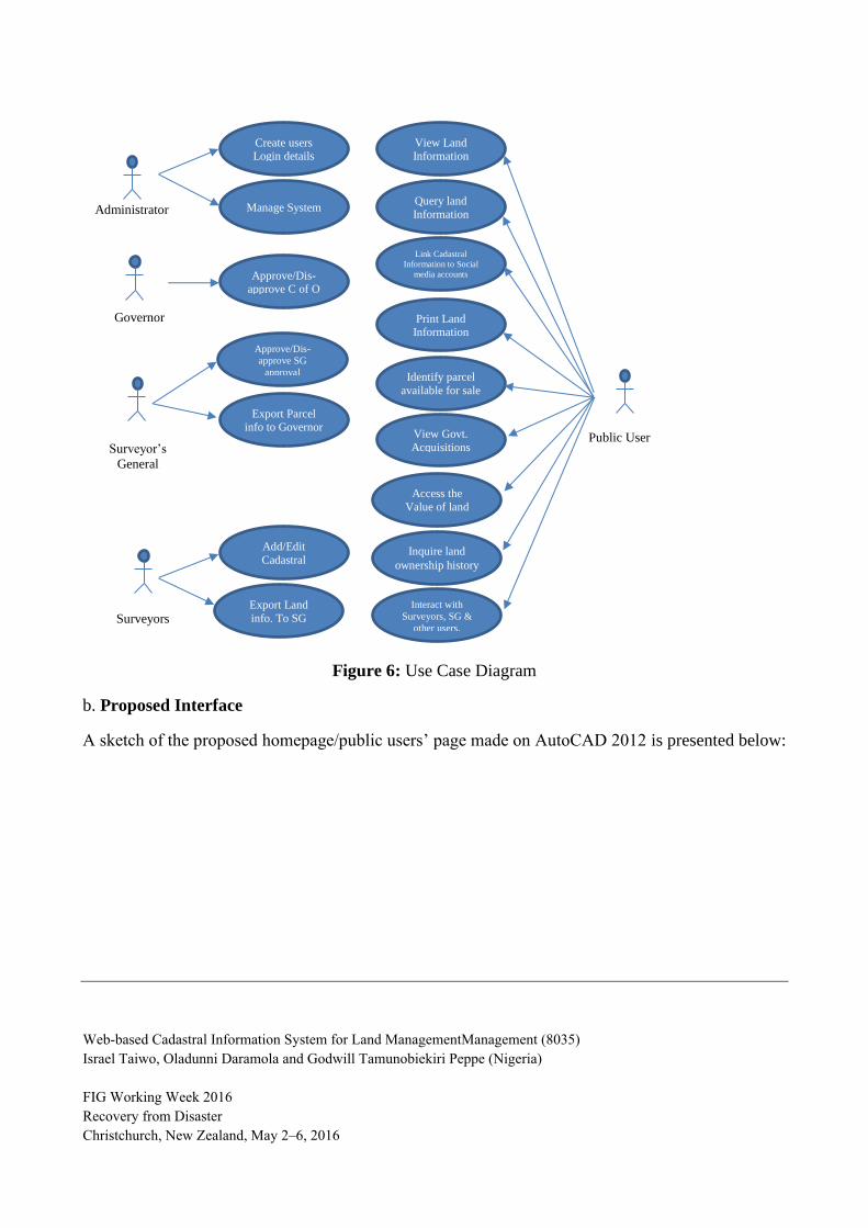
The designed system was designed such that professionals could log on to access their respective
pages. The system comprised five types of access right conferred on the under-listed categories of
users. The generic page available to all users is the homepage; this contains links to other pages of
different access rights. The users of the system include the following:
i. Public Users (Land Owners)
ii. Land Surveyors
iii. Surveyors’ General
iv. Governor’s Page
v. Administrators Page
The use case diagram for the system is shown below:
Publish and View cadastral
information on the web
12,82%
Identify Land parcel available for acquisition on the web
20,51%
See government acquisitions on the
web 10,26%
Identify the approximate cost of land in an area on
the web 7,69%
Inquire history of land ownership on
the web 20,51%
Allow you to interact with other Surveyors
on the web 12,82%
Allow You to interact with your Clients on the web
2,56%
Allow you to interact with the office of the surveyors general on
the web 12,82%
Web-based Cadastral Information System for Land ManagementManagement (8035)
Israel Taiwo, Oladunni Daramola and Godwill Tamunobiekiri Peppe (Nigeria)
FIG Working Week 2016
Recovery from Disaster
Christchurch, New Zealand, May 2–6, 2016
Figure 6: Use Case Diagram
b. Proposed Interface
A sketch of the proposed homepage/public users’ page made on AutoCAD 2012 is presented below:
Create users Login details
Manage System
Approve/Dis-approve C of O
Approve/Dis-
approve SG
approval
Export Parcel info to Governor
Add/Edit
Cadastral
Information
View Land Information
Query land
Information
Link Cadastral
Information to Social
media accounts
Print Land Information
Identify parcel
available for sale
Surveyors
View Govt.
Acquisitions
Access the
Value of land
Inquire land
ownership history
Interact with
Surveyors, SG &
other users.
Export Land
info. To SG
Surveyor’s
General
Governor
Administrator
Public User
Web-based Cadastral Information System for Land ManagementManagement (8035)
Israel Taiwo, Oladunni Daramola and Godwill Tamunobiekiri Peppe (Nigeria)
FIG Working Week 2016
Recovery from Disaster
Christchurch, New Zealand, May 2–6, 2016
Figure 7: Proposed Users Interface
4.1 METHODOLOGY
4.2 Data Collection
Data is the fundamental part of any management tool (Taiwo et.al, 2013). The effectiveness of
spatial information systems depends on the comprehensiveness, consistency, and integrity of its
spatial database. Open standard map layer (OSM layer) was used as a base map for the interface.
The OSM layer was acquired with QGIS leaflet from the open layers data repository. Being an
open layer, the source of the data needs to be verified. Editing and updating the layer was another
challenge. In order to verify the OSM layer and to break the reliance of the system on internet
connectivity during the development phase, shapefiles (.shp) and drawing (.dxf) files cognate to the
course were acquired from the office of the Surveyor’s General of the federation, from DgitalFIRM
and from Chief P.A.O. Adeleye and associates. The layers under listed below were eventually used
in the execution of the prototype:
i. Ekiti State Boundary
ii. Ekiti state LGA Boundary map
iii. Road map
iv. Towns
v. Parcel Layer.
Web-based Cadastral Information System for Land ManagementManagement (8035)
Israel Taiwo, Oladunni Daramola and Godwill Tamunobiekiri Peppe (Nigeria)
FIG Working Week 2016
Recovery from Disaster
Christchurch, New Zealand, May 2–6, 2016
Figure 8: Cartographic model of the Project
4.3 System Tools and Methods
4.3.1 Projection Parameters
The layers acquired were of different projection and coordinate systems. The acquired layers were
re-projected into a common coordinate system using the “on the fly” function of QGIS 2.6 software.
Currently, WGS 84 uses the EGM96 (Earth Gravitational Model 1996) geoid, which was revised in
2004. This geoid defines the nominal sea level surface by means of a spherical harmonics series of
degree 360 (which provides about 100 km horizontal resolution). The deviations of the EGM96
geoid from the WGS 84 reference ellipsoid range from about −105 m to about +85 m.
Ekiti State
Boundary Layer
Ekiti State LGA
Boundary Layer
Ekiti State
Road map
Layer
OSM Layer
Geo
refe
rence
/R
estr
uct
uri
ng
Ekiti State
Town Layer
Bearings &
Distances
Parcel Layer
Spatial
Database
Coordinates
Projection System: EPSG 4326 (WGS 84)
Equatorial Radius: 6378137
Flattening f : 1/298.257223563.
Figure 9: Projection Parameters (Source: Wikipedia Dictionary)
Web-based Cadastral Information System for Land ManagementManagement (8035)
Israel Taiwo, Oladunni Daramola and Godwill Tamunobiekiri Peppe (Nigeria)
FIG Working Week 2016
Recovery from Disaster
Christchurch, New Zealand, May 2–6, 2016
WGS 84 was adopted as the projection system because of its uniform referencing system for all
points on the earth surface.
4.3.2 Geometric Primitives
The layers acquired were based on the three known geometric primitives (points, lines and
polygons). Below is a categorization of the geometric primitive associated with each layer:
Table 2: Geometric Primitives of Spatial Layers
Layer Geometric primitive
Ekiti State Boundary Polygon
Ekiti State Local Government Polygon
Road Map Lines
Towns Points
Parcel Layer Polygons
During the research, it was discovered that polygon maps delineating towns within the study area
were not available, therefore, it was identified during the research work that there is need for town
demarcation within the study area, such that queries can be carried out using town criteria other
than the Local Government Area criterion which was implemented in this prototype.
4.3.3 Implementation Requirements and tools
In designing, developing and implementing the system, wares with the following capacities were
used:
Hardware:
i. Asus VIVObook F200L Notebook PC (Core i3, 500GB Hard disk, 4GB RAM)
ii. HP TouchSmart tm2-2050us Notebook (Core i3, 500GB Hard disk, 4GB RAM)
For the enterprise level implementation, a machine with the following minimum requirements are
advised:
a. Hard disk size: 40Gb
b. 1GB RAM
Software:
In developing the prototype system, the following were used:
i. Microsoft windows 8
ii. Microsoft Office Suite
iii. QGIS 2.6 (Brighton)
iv. Internet Explorer
v. Mozilla Firefox
vi. WAMP server
vii. Macromedia Dreamweaver 8
For an enterprise level implementation computer machines with browsers such as Internet Explorer,
Google chrome, or Mozilla Firefox can be used.
Web-based Cadastral Information System for Land ManagementManagement (8035)
Israel Taiwo, Oladunni Daramola and Godwill Tamunobiekiri Peppe (Nigeria)
FIG Working Week 2016
Recovery from Disaster
Christchurch, New Zealand, May 2–6, 2016
5. SYSTEM ANALYSIS
5.1 System Preference
During the research, questions was asked to determine the type of system surveyors would prefer
for cadastral information management. This is owing to the fact that there are two different types of
systems commonly used in the management of cadastral information. This includes Cadastral
Information System and Land Information System. Cadastral information system is explicitly for
managing cadasters, while Land information system allows more manipulations aside cadastre
management. One significant difference between the two systems in question is that –Cadastral
Information System could be seen as a subsidiary of Land Information System.
Table 3: System Preference
Which of these do you prefer
Frequency Percent
Valid
Percent
Cumulative
Percent
Valid Cadastral Information System 3 21.4 23.1 23.1
All-in-One Land Information System 10 71.4 76.9 100.0
Total 13 92.9 100.0
Missing 0 1 7.1
Total 14 100.0
Figure 10: System Preference
From the above, despite the fact that Land Information System will require more professionals in
addition to the Land Surveyors for its manipulations compared to a Cadastral Information System,
the Surveyors preferred an all-inclusive LIS where several professionals will meet to produce
synergy, without trading efficiency for profit gain.
Cadastral Information
System 23%
All-in-One Land Information
System 77%
Web-based Cadastral Information System for Land ManagementManagement (8035)
Israel Taiwo, Oladunni Daramola and Godwill Tamunobiekiri Peppe (Nigeria)