Page 1
Web GIS: Steps for SuccessBonnie Stayer, Esri
Allison Baker, Senior Data Analytics Manager, Federal Communications
Commission
Brian Funk, Director, NCI, Federal Communications Commission
Information Technology Center
Page 2
Overview
• Not a step-by-step how to, but guidance and tips
• A discussion of best practices for you to consider
• Topics
- Establish your Web GIS portal
- Configure for best experience
- Engage users
Page 3
Your Web GIS
Your geographic
information portal
Professional
GIS
Executive
access
Public
engagement
Work
anywhere
Knowledge
workers
Developer
community
Enterprise
integration
ArcGIS
Page 4
Establish the
vision and
governance
Page 5
Vision and Governance
• Know the answers to these questions –
- Who are the champions?
- Who are the stakeholders?
- What is the mission and vision?
- What workflows will it support?
- What are the deliverables?
- Who is the audience?
• Consider the following-
- Establish a curator, or group of curators
- Form a governance committee
Page 6
Suggestions
• Communicate early, often, and well
• Prototype and test before rolling out
• Implement successful patterns
• Establish essential procedures and guidelines
• Be flexible, adapt, and evolve
Page 7
Configure your
portal home
Page 9
Organization settings
• Home page (banner and background)
• Featured content (ribbon)
• Gallery content
• Default map and basemaps
• Custom app templates
• Utility services
• Security settings
• More…
Page 10
Other ways to deliver access to your content
• Embed maps and apps
• Group gallery app template
• Group gallery ribbon
• Open Data
Page 11
Establish your
brand
Page 12
Organization visual branding
Page 14
Organization profile
Page 15
Organize your Web
GIS portal
Page 16
Groups help organize activities
• Access to resources
• Collaboration within the organization
• Collaboration between organizations
Page 17
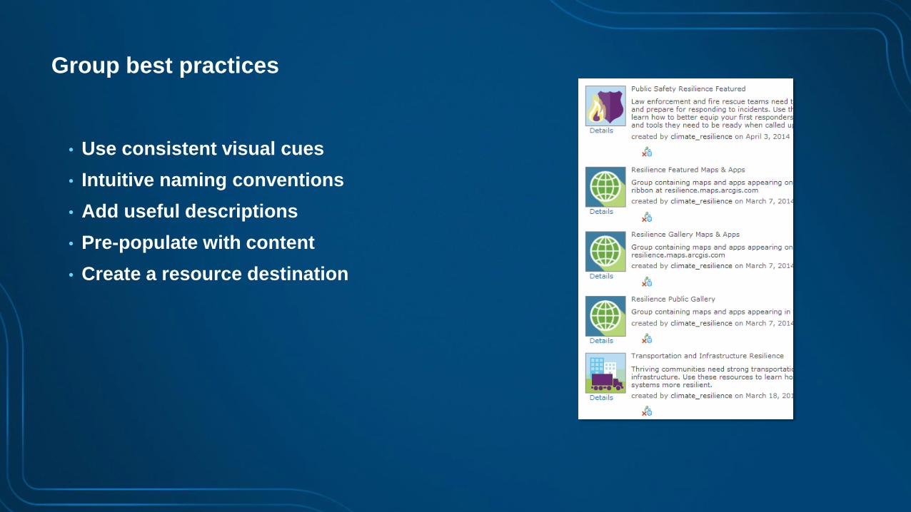
Group best practices
• Use consistent visual cues
• Intuitive naming conventions
• Add useful descriptions
• Pre-populate with content
• Create a resource destination
Page 18
Open Data Groups Department/Project Groups
Admin Groups
Page 19
Group affiliation
• Groups can be:
- Private
- Organization only
- Public
• Membership:
- User can apply
- Invite only
• Contributors:
- Only group owner
- All members
Page 20
Add useful content
Page 21
Add existing content
• ArcGIS services
• Shapefiles, spreadsheets, map templates, and more…
• Create new hosted services as needed
Page 23
Registering your ArcGIS services
(1) Add service
(2) Configure
(3) Save layer
Page 24
Make your content discoverable
Organization
gallery
Description,
Summary, Access,
Use Constraints and
Tags
Groups
Page 26
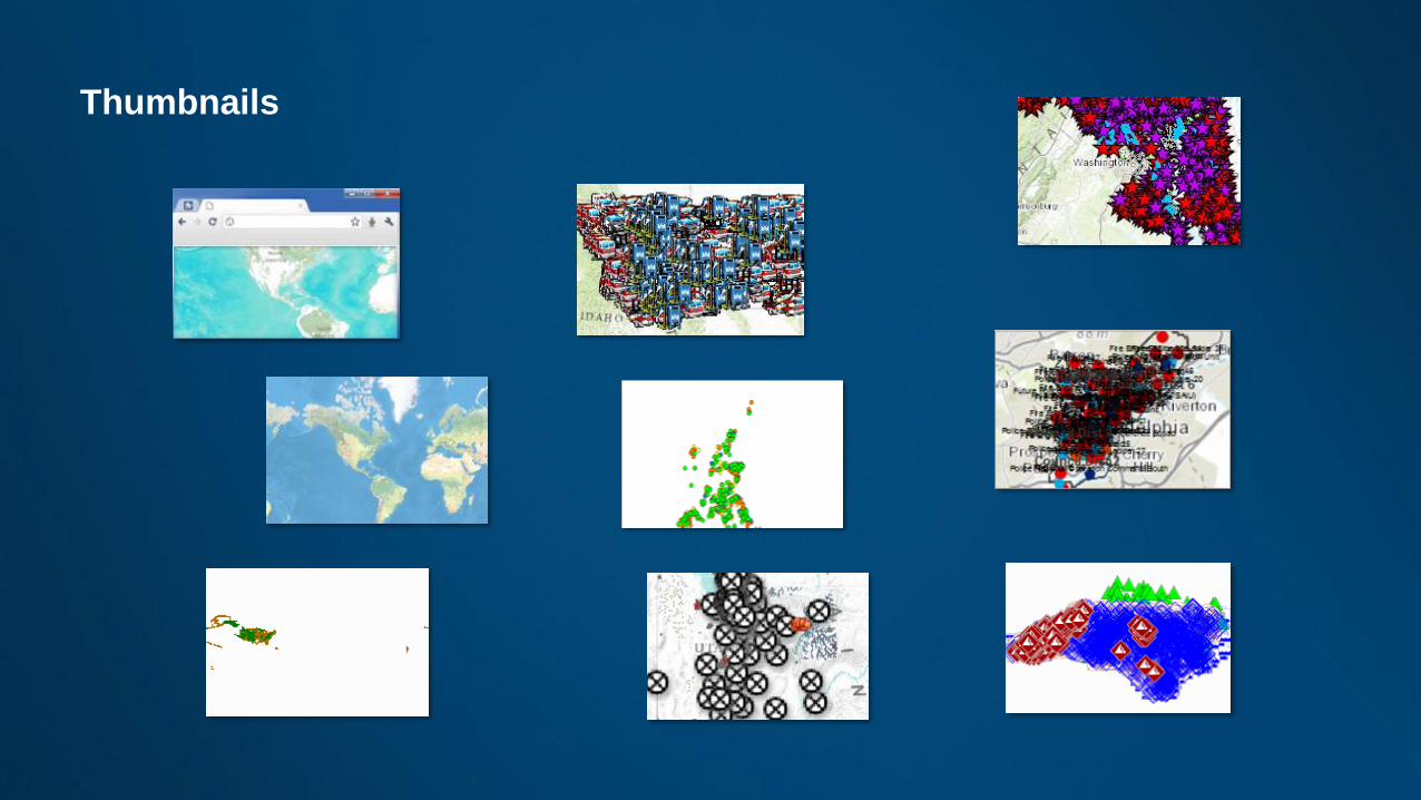
Better thumbnails Location
hints
Graphic hints
Content hints
Hybrid
Page 27
Create useful
and compelling
information
products
Page 28
MapsHow we communicate geographically
Page 29
Pop-upsConsider the entire information product
Charts Images and Links
Formatted text
and Charts
Page 30
AppsPutting together the entire information experience
Page 31
Map viewer vs. appsDeliver your map in the right context
Map viewer (for authoring)
Storytelling basic template
Public information
templateStory map tour
Page 34
Invite users
Use enterprise logins
(Best)
Assign level and
role
‘Pre-establish’ recommended
Invite from file
Page 35
Levels Roles Privileges
Viewer User Publisher Administrator Custom
Use maps and apps
Create items Optional
Join and create
groups Optional
Edit features Optional
Perform analysis Optional
Publish hosted
services Optional
Manage the
organization
and users Optional
Level 1 – View only
Level 2 – Any other
roles/privileges,
including app
access
Page 36
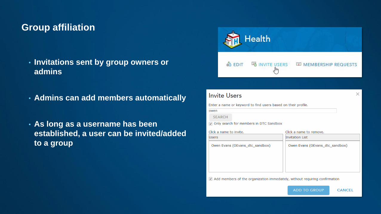
Group affiliation
• Invitations sent by group owners or
admins
• Admins can add members automatically
• As long as a username has been
established, a user can be invited/added
to a group
Page 38
Connect with
enterprise
workflows and
systems
Page 39
Your ArcGIS organization serves everyone
ArcGIS Pro
Esri Maps for Office,
Cognos, Sharepoint,
etc.
Collector for ArcGIS
Dashboard for ArcGIS
Navigator for ArcGIS
Page 40
Promote your Web
GIS
Page 41
Promote your organization
Page 42
Review and Q & A
1. Establish the vision and governance
2. Configure your Web GIS portal home
3. Establish a brand for your content
4. Organize your Web GIS portal and
assets
5. Add content and leverage your work
6. Create useful information products
7. Invite members
8. Connect with your enterprise
9. Promote your Web GIS
Page 43
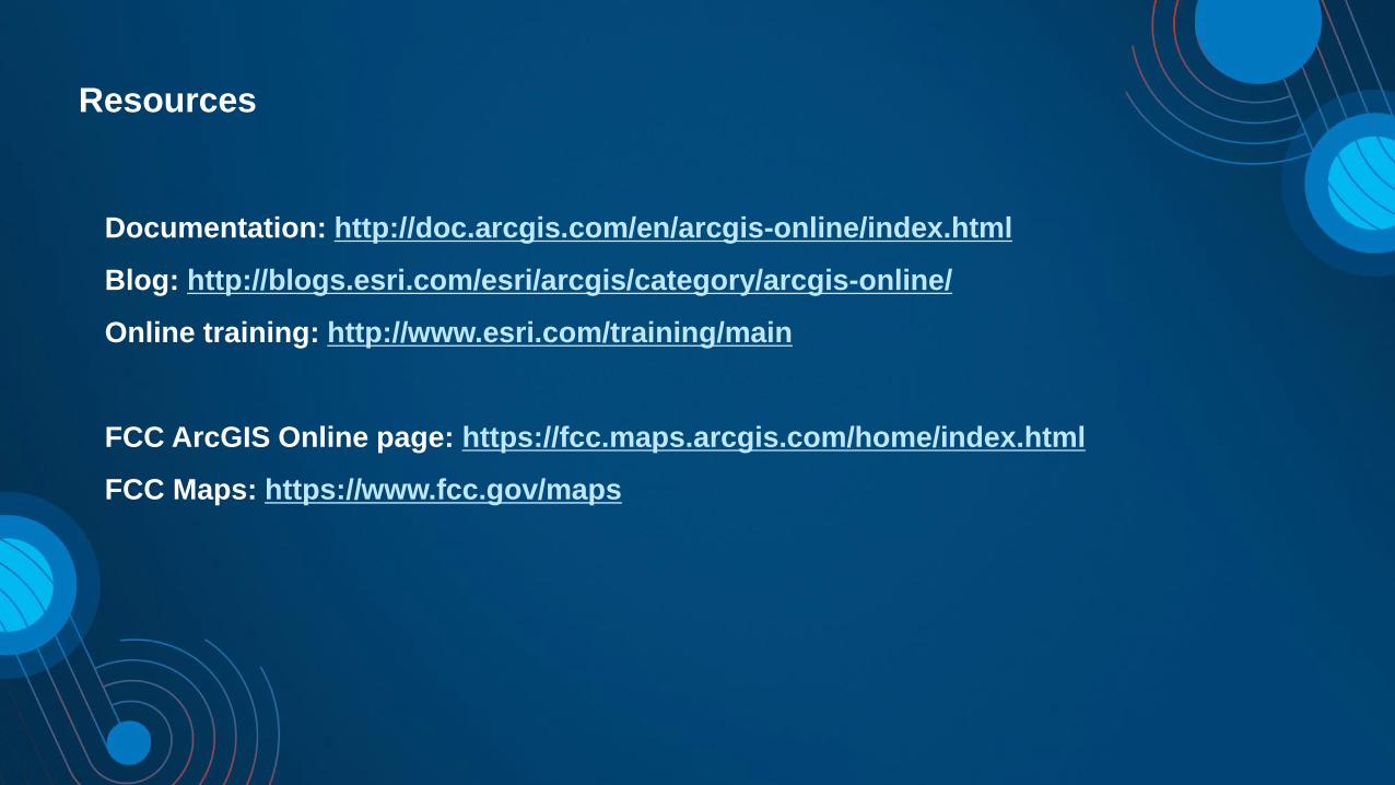
Resources
Documentation: http://doc.arcgis.com/en/arcgis-online/index.html
Blog: http://blogs.esri.com/esri/arcgis/category/arcgis-online/
Online training: http://www.esri.com/training/main
FCC ArcGIS Online page: https://fcc.maps.arcgis.com/home/index.html
FCC Maps: https://www.fcc.gov/maps
Page 44
Upcoming Sessions
• 11:00am – 12:00pm
- Getting the Most Out of ArcGIS Web App Templates – Room 150A
- Developing an Open Data Strategy – Room 156
• 1:30pm – 2:30pm
- ArcGIS Enterprise: Setting It Up – Room 147B
- Establish an Initial Operating Capability for Your Organization – 150A
• 2:45pm – 3:45pm
- ArcGIS Enterprise: Portal Administration – Room 147B
- ArcGIS Online: Administering Members in Your Organization – 156
• 5:15pm – 6:15pm
- ArcGIS Online: Collaboration for Your Organization – Room 156
Page 45
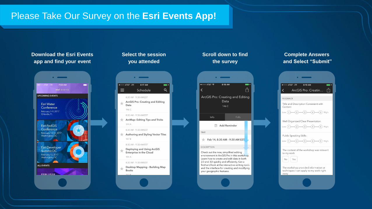
Please Take Our Survey on the Esri Events App!
Select the session
you attended
Scroll down to find
the survey
Complete Answers
and Select “Submit”
Download the Esri Events
app and find your event
Page 46
Print Your Certificate of Attendance
Print stations located in the 140 Concourse
Monday
12:30 PM – 6:30 PM
GIS Solutions Expo,
Hall B
5:15 PM– 6:30 PM
Expo Social,
Hall B
Tuesday
10:45 AM– 5:15 PM
GIS Solutions Expo,
Hall B
6:30 PM– 9:30 PM
Networking Reception,
Smithsonian National Air
and Space Museum