Name: Date: Homeroom: 6 th Grade World History Objective: SWBAT identify the key geographic and climatic features of East Asia that led to early human settlement in the region. Do Now Directions: Match each geographic term with the correct definition. Geographic Terms Definitions 1. Island a. Avery tall high, natural place on Earth - higher than a hill. 2. River b. A large body of salt water that surrounds a continent. 3. Desert c. A large, flowing body of water that usually empties into a sea or ocean. 4. Gulf d. A large body of water surrounded by land on all sides (freshwater) 5. Plateau e. A part of the ocean (or sea) that is partly surrounded by land (it is usually larger than a bay). 6. Basin f. A place where the Earth’s surface is lower than in other areas 7. Lake g. A large, flat area of land that is higher than the surrounding land. 8. Ocean h. A large body of salty water that is often connected to an ocean. This water form may be partly or completely surrounded by land. 9. Sea i. A very dry area. 10. Mou ntain j. Land that is surrounded on all sides by water. Welcome to China!
Transcript
Name: Date:Homeroom: 6th Grade World HistoryObjective: SWBAT identify the key geographic and climatic features of East Asia that led to early human settlement in the region.
Do Now
Directions: Match each geographic term with the correct definition.
Geographic Terms
Definitions
1. Island a. Avery tall high, natural place on Earth - higher than a hill.2. River b. A large body of salt water that surrounds a continent.3. Desert c. A large, flowing body of water that usually empties into a sea
or ocean.4. Gulf d. A large body of water surrounded by land on all sides
(freshwater)5. Plateau e. A part of the ocean (or sea) that is partly surrounded by land
(it is usually larger than a bay).6. Basin f. A place where the Earth’s surface is lower than in other areas7. Lake g. A large, flat area of land that is higher than the surrounding
land.8. Ocean h. A large body of salty water that is often connected to an ocean.
This water form may be partly or completely surrounded by land.
9. Sea i. A very dry area.10.Mountain j. Land that is surrounded on all sides by water.
Welcome to China!
Fast Facts:
11. Hemisphere:
______________
12. Climate: ______________Map MinuteAncient China
Quiz: ______________
1. Yellow River (Huang He) = _____ 5. Himalayan Mountains= _____2. Taklimakan Desert= ______ 6. East China Sea= _____3. Gobi Desert= _____ 7. Yangtze River (Chang Jiang) = _____4. India= _____ 8. Identify China on the blank world map.Map Minute Expectations
1. Study every night2. Quiz will be at the end of the week most times3. Circle the ones you got wrong and PRACTICE, PRACTICE, PRACTICE!
BA
C
D
E
FG
Use GRIT to independently make sense of this challenge!Etiquette for Watching a Movie in History Class
1. Make sure your legs are in front of you, and your feet are flat on the floor (NOT on the chair or desk in front of you or beside you!)
2. Preview the questions so you know what to listen for 3. Make sure to face forward the whole time so you don’t
miss a minute of the action!4. Use the pauses in the movie to take notes or answer the questions in your Do Now
Packet.5. Respect other’s movie time by staying silent
DURING MOVIE QUESTIONS
Two important factors limited China’s contact with outsiders:
Building Study HabitsHow much do you need to study tonight?
7 – 8 right = You’re killing it! Keep practicing for 5 minutes tonight!
5 – 6 right = Almost there! Practice some more for 8 minutes tonight!
3. The ____________________________________ is a vast area stretching from Mongolia to
China.
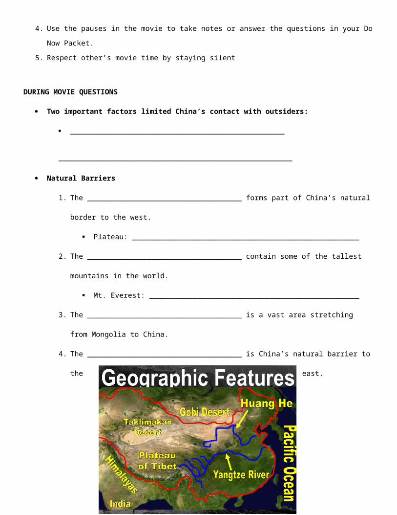
4. The ____________________________________ is China’s natural barrier to the east.
Today’s BIG QUESTION:
How did the geography and climate of East Asia impact early human settlement?Directions: As you read, draw a box around geographic features and answer the questions in the margins.
China is a large country in eastern Asia. The world’s highest mountains, the Himalayas separate China from India. The world’s largest desert the Taklimakan is in western China. The country also has some of the world’s longest rivers. The climate is just as extreme as its physical features. The weather can vary from ice storms to sand storms or even extreme heat. To understand Chinese history it is helpful to divide China into two main areas: Outer and Inner China.
Outer China includes the western and northern parts of present-day China. This is an area of great extremes in climate and physical features. In the southwest, China is bounded by the Himalayan Mountains. It also contains the Tibet-Qinghai Plateau, the world’s largest. A plateau is a flat elevated highland. This region is a bitterly cold place
1. What are the two major geographic regions China can be divided in?
2. What major geographic features make up Outer China?
to live. There are only about fifty days a year without frost. Snowstorms are common, even in July. In the northwest, the major region is the Northwestern Desert, which is extremely hot. In the northeast lies the Northeastern plain which has short, hot summers and long, dry, freezing, winters. The Taklimakan Desert is considered one of the most dangerous deserts in the world. The huge sand dunes shift and change as the wind blows the sand around. Unlike the Taklimakan Desert the Gobi Desert has very few sand dunes. Its surface is made up of small pebbles and tiny bits of sand.
Outer China did not have good farmland, so fewer people settled there than in Inner China. The people who did live on the Tibet-Qinghai Plateau were nomads who moved frequently to find new grazing land. The animals supplied most of the nomad’s needs. In the Northwestern Deserts, there were a few permanent communities located near sources of water. The Northeastern Plain was too cold and dry for much farming, so people here were also nomads. They got some supplies form their animals, but they often invaded Inner China to get supplies. Eventually the people of Inner China built the Great Wall to keep these invaders out.
Inner China includes the southeastern part of present-day China. It is a land of rolling hills, river valleys, and plains. Rivers flow through this area, like the Huang He (Yellow) River. The rivers often enriched the soil by flooding. They also provide water for irrigation. These physical features made Inner China more attractive to settlers than outer China. Inner China has two major regions with very different climates. The northern region is the North
3. How were the 3 deserts different from each other?
4. How did people survive in Outer China?
5. How did the Huang He River influence how people lived?
6. How did the geography of the North China Plain influence how people lived?
7. How did the geography of the Chang River Basin influence how
China Plain. The drier, cooler climate allowed farmers to grow wheat and millet. They raised cattle, sheep, oxen, pigs, and chickens. They herded cattle, water buffalo, and horses. Settlers built permanent homes out of rammed earth (soil tightly packed to make solid walls). To the south are the low river plains of the Chang River Basin. Near the Chang Jiang (Yangzte) River, there was limited farmland and grazing areas for animals such as cattle. But rice thrived in this warm, rainy area. As early as 10,000 BCE, settlers were able to grow rice in the river valley. They also raised pigs and poultry. Nearby seas provided plentiful seafood. People built permanent houses so they could stay in one place and tend their animals and crops.
China’s geography kept early settlements in Inner China isolated. Only a narrow coastal plain linked the Northeastern Plain to Inner China. Later in Chinese history, the same geographic features that kept ancient China isolated also made it difficult to govern a developing China as a unified state. The harsh geography and huge distances made communication and transportation difficult, and interfered with the movement of military forces.
people lived?
8. Why did most of Chinese history take place in Inner China?
Today’s BIG QUESTION:
How did the geography and climate of East Asia impact early human settlement?
Guided Discourse Norms:1. Track the speaker2. Use Habits of Discussion3. Support your comments using evidence from the documents4. Capture discussion notes in the space provided
Name: Date:Homeroom: 6th Grade World HistoryObjective: SWBAT identify the key geographic and climatic features of East Asia that led to early human settlement in the region.
Exit Ticket
1. What does the word ISOLATE mean?
a. to separate b. to strengthen
c .to weaken d. to stretch
2. All of these are natural barriers that ISOLATED China except:
a. East China Sea b. Tibetan Plateau
c. The Himalayas d. India
3. What continent is China on?
a. Asia b. Africa
d. Europe d. America
4. Why is the Huang He River called the Yellow River?
a. The river is yellow because of the pollution from the farmers
b. The river is yellow because it needs more silt for agriculture
c. The river is yellow because of silt blown by wind from the Gobi desert
d. The river is yellow because of the yellow fish swimming in it
5. What barriers separated India from China?
a. The Himalayas
b. The North China Plain
c. The Gobi Desert
d. The Nile River
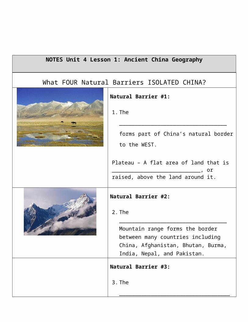
NOTES Unit 4 Lesson 1: Ancient China Geography
What FOUR Natural Barriers ISOLATED CHINA?Natural Barrier #1:
1. The __________________________________ forms
part of China’s natural border to the WEST.
Plateau – A flat area of land that is ____________________________, or raised, above the land around it.
Natural Barrier #2:
2. The __________________________________ Mountain range forms the border between many countries including China, Afghanistan, Bhutan, Burma, India, Nepal, and Pakistan.
Date:Homeroom: 6th Grade World HistoryObjective: SWBAT identify the key geographic and climatic features of East Asia that led to early human settlement in the region.
Directions: Annotate the text by boxing in key terms and details about geographic features.
1. Ancient China is part of a region that is now called:(a) Modern China(b) Sub-Continent(c) East Asia(d) Southwestern Asia
2. In paragraph 2, the word “awe-inspiring” likely means which of the following?(a) Horrifying
Source: “Ancient China” History Alive, 199.The land of ancient China is part of a vast region that today is called mainland East Asia. Mainland East Asia includes the present-day countries of China, Mongolia, North Korea, and South Korea. In ancient China, a series of empires controlled territory in mainland East Asia that, at times, included parts of present-day Mongolia and the Korean Peninsula. The physical geography of mainland East Asia had a dramatic effect on the settlement of ancient China. In the southwestern part of the region, the Himalaya Mountains prevented settlement. A high plateau lies north of these mountains. Because of its awe-inspiring elevation, this region has been called the “roof of the world.” The weather is extremely cold here all year round. To the north of this plateau lies desert land, where temperatures are too hot in summer and too cold in winter to make it a good place for people to live. Some groups did roam the area as nomads, raising livestock and moving from place to place, but life was hard for them.To the east of his hostile land, the land is much more moderate. Hills, valleys, and plains are easy to navigate. Rivers provide fertile land for farming. Even the weather is milder, without the extremes of the western part of the country. For these reasons, most ancient Chinese chose to make their homes in this area. Over time, villages developed. Because of China’s physical boundaries, including mountains and deserts, the Chinese civilization developed in isolation for thousands of years.The stability of early villages allowed empires to arise. Powerful leaders unified the country. Advances in civilization allowed empires to conquer more and more territory. The most advanced of these empires, the Han, opened ancient China to trade relations with other
(b) Amazing(c) Interesting(d) Useless
3. Which of the following sentences best explains how “the physical geography of mainland East Asia had a dramatic effect on the settlement of ancient China?”
(a) “Because of its awe-inspiring elevation, this region has been called the ‘roof of the world.’”
(b) “Because of China’s physical boundaries, including mountains and deserts, the Chinese civilization developed in isolation for thousands of years.”
(c) “In ancient China, a series of empires controlled territory in mainland East Asia that, at times, included parts of present-day Mongolia and the Korean Peninsula.”
(d) “The stability of early villages allowed empires to arise.”
4. What does the world “hostile” in paragraph 3 likely mean? (a) Hospitable(b) Complex(c) Not hospitable(d) Unique
5. What was the name of the trade route that was over 4,000 miles long. (a) Yellow Road(b) Silk Road(c) Han Road(d) Camel Caravan
6. How did ancient china’s geography impact early human settlement?