Page 1
Evidence Given on Behalf of the Applicant: WMCA
Transport Modelling
Main Proof of Evidence
Himanshu Budhiraja
Wednesbury to Brierley Hill
Extension
Transport and Works Act 1992
The Transport and Works
(Inquiries Procedure) Rules 2004
APP/P4.119 February 2019
Page 2
APP/P4.1
Page 2 of 40
1. Introduction
Qualifications and Experience
1.1. My name is Himanshu Budhiraja. I am a Divisional Director with Pell Frischmann, a
consultancy firm specialising in planning, design, engineering, and construction
services for public and private sector clients. Our transportation practice provides
the full range of specialist transportation services including traffic engineering,
transport modelling, development of business cases, appraisal and evaluation of
scheme impacts and transport policy and strategy advice to both public and private
sector clients.
1.2. I am also the Discipline lead for Transportation within the Midland Metro Alliance
(MMA), and in that role I am the Director responsible for the work undertaken in
developing the microsimulation traffic model (VISSIM) for the Wednesbury to Brierly
Hill Extension (WBHE). This suite of transport models have been used to
understand the impact of the operation of the proposed WBHE on the highway
network in the vicinity of the Merry Hill Shopping Centre which is owned by Intu
(referred to as ‘Intu Merry Hill’).
1.3. Additionally, I have also been the director responsible for the work undertaken to
update the transport models that were developed to assess the junction capacities
at the junctions that the Metro passes through. I am familiar with the tram route and
the objectives of the Metro project.
1.4. I have an M.Sc. in Transport Planning and Traffic Engineering from the Institute of
Transport Studies, University of Leeds and a Master in Planning (Transport
Planning). I have been a Member of Chartered Institution of Highways and
Transportation since 2005.
1.5. I have worked for engineering consultancies in the UK and abroad since 1999. My
experience in the UK includes working for the transportation services business of
several companies, including Atkins, Jacobs, WSP and Pell Frischmann, and
working in Local Government organisations, including Transport for West Midlands
(formerly Centro).
1.6. During my career, I have worked on the planning, development and implementation
of a number major transportation schemes and programmes.
Scope
1.7. My evidence covers the background of the overall transport modelling undertaken to
understand the impacts of the operation of the WBHE on local road network. It
Page 3
APP/P4.1
Page 3 of 40
summarises the impacts of WBHE on Merry Hill Shopping Centre, on Churchill
Shopping Centre in Dudley and on the rest of the local road network where WBHE
interacts with the highway.
1.8. I deal in my evidence with the following matters in the Statement of Matters [GEN/3]
issued by the Secretary of State for Transport, being the matters about which the
Secretary of State particularly wishes to be informed for the purposes of his
consideration of these applications.
Matter 4(a) the impacts on access to and within the area, including the
effects on local road networks, access to businesses and car parks, and
access by emergency vehicles; and
Matter 4(c) the impacts on members of the general public, including users of
the Churchill Shopping Centre in Dudley and the Merry Hill Shopping Centre
in Brierley Hill.
With regards to the above matters my evidence covers the impact of the operation of
WBHE on the local road networks where the proposed WBHE interacts with the
highway, including its impact on Churchill Shopping Centre in Dudley and the Merry
Hill Shopping Centre in Brierley Hill. My colleague Mr. Ian Collins has covered
specific impacts related to access (to business, car parks and emergency vehicles)
and construction in his evidence [APP/P3.1].
1.9. This evidence addresses the following remaining objections:
OBJ/07 Jessops Europe Limited
OBJ/10 Intu
OBJ/11 Waterstones Ltd
OBJ/15 MFG
OBJ/20 and OBJ/20/W1 McDonalds
OBJ/21 Argos Ltd
OBJ/22 and OBJ/W.1.1-1.4 TJX UK
1.10. Final summary and conclusions can be found in Section 8.
Witness Declaration
1.11. The evidence I shall give is true, given in good faith and represents my
professional opinion regarding the merits of the Proposed Order and I have carried
out my assessment in accordance with the Code of Professional Conduct of the
Chartered Institution of Highways and Transportation.
Page 4
APP/P4.1
Page 4 of 40
2. Overview of Transport Modelling
2.1. This section of my evidence gives an overview of the overall transport modelling that
has been undertaken by consultants on behalf of the West Midlands Combined
Authority (WMCA) or Transport for West Midlands (TfWM) for the Midland Metro
(Wednesbury to Brierley Hill and Miscellaneous amendments) Order 2005 (the 2005
Order) and any subsequent transport modelling undertaken to date.
Transport Assessment for The Midland Metro (Wednesbury to Brierley Hill and
Miscellaneous amendments) Order 2005
2.2. On 20 December 2004, the Secretary of State for Transport (“the Secretary of
State”) issued a decision letter [WBHE/B6] approving the 2005 Order’ [WBHE/B2]
to construct and operate an extension to Line 1 of the Metro system.
2.3. In considering whether to make the 2005 Order [WBHE/B2], the Secretary of State
had available to him the application documents as listed below in paragraph 3.6 of
WMCA Statement of Case [WBHE/F5], the report of the Inspector who heard the
Inquiry [WBHE/B8], and the materials submitted to the Public Inquiry. This included
Environmental Statement [WBHE/B9], that had summarised the transport impacts of
the scheme.
Junction Capacity Assessment
Mott MacDonald Junction Capacity Assessment - July 2016 (referred to as Mott
MacDonald Assessment) [WBHE/F20]
2.4. TfWM commissioned consultant Mott MacDonald to review and develop the WBHE
scheme further since the 2005 Order was made. As a part of that commission Mott
MacDonald, assessed key junctions along or in close vicinity of the proposed WBHE
route. As summarised in Mott MacDonald Assessment [WBHE/F20], the junction
capacity assessment approach and parameters for this assessment were agreed
with Sandwell Metropolitan Borough Council (SMBC) and Dudley MBC (DMBC).
2.5. The junctions were assessed for the base year 2016 (which was the current year at
the time of assessment) and future years (2021 and 2031) (with and without the
proposed tram scheme in place).
MMA update of Mott Macdonald Junction Capacity Assessment – 2018 [APP/P4.3](
Appendix A)
2.6. MMA in 2018 updated the Mott MacDonald Assessment [WBHE/F20] junction
capacity analysis where there have been any changes in the design as a result of
the preliminary design proposals or where further signal optimisation could improve
Page 5
APP/P4.1
Page 5 of 40
the overall performance of the junction. This is wherever the WBHE interacts with
the highway network. This update has used the traffic models, including future
forecast flows and any modelling assumptions, directly from Mott MacDonald
Assessment [WBHE/F20] and only updated any changes to the scheme outline
design since Mott MacDonald Assessment [WBHE/F20].
2.7. This junction capacity assessment has formed the basis of assessing the impact of
WBHE on the local road network, including users of Churchill Shopping Centre in
Dudley.
2.8. Further details of this is provided in Section 4 of my evidence.
Transport Modelling to assess the impact of WBHE in the vicinity of Merry Hill
Shopping Centre
WBHE –Scheme proposals in the vicinity of Merry Hill Shopping Centre (2004 Public
Inquiry Scheme)
2.9. As stated in the WMCA’s Statement of Case. [WBHE/F5], WMCA has been
engaging with Intu, the owners of the Waterfront and Merry Hill Shopping Centre,
since October 2015 when the WMCA former Head of Metro Development, Peter
Adams, gave a presentation on the proposals for the WBHE at a meeting at Intu’s
offices. This engagement particularly focused on the WBHE proposals in the vicinity
of Merry Hill Shopping Centre.
2.10.The scheme proposals that were presented at this meeting included the proposed
WBHE to cross the Level Street/ The Embankment/ Waterfront Way South junction
at-grade by converting the existing roundabout to a signalised crossroads. This is
necessary to allow WBHE to cross the junction safely. South of the Level Street/ The
Embankment junction the WBHE, at the time of the 2004 Inquiry, was proposed to
be on an embankment (requiring a retaining wall and mass fill solution) running
along Dudley Canal to the Brierley Hill Terminus. My colleague Ian Collins details
this further in his proof [APP/P3.1]. This required the section of The Embankment
between Level Street and Central Way to be one-way in the south bound direction
only, in order to accommodate the Metro on the embankment (hereafter referred to
as 2004 PI Scheme).
Engagement with Intu and Dudley - Transport modelling approach to assess the
impacts on highway network in the vicinity of Merry Hill Shopping Centre
2.11.WMCA has continued to meet with Intu and Dudley MBC on a regular basis to
progress the design and development of the WBHE insofar as affects Intu’s interests
and/or other stakeholders that hold a leasehold interest in units of the Merry Hill
Page 6
APP/P4.1
Page 6 of 40
Shopping Centre. Intu’s concerns related to the scheme proposals at the time of the
2004 Public Inquiry, included assessment of the impacts of alterations to section of
The Embankment between its junctions with Level Street and Central Way by
making it one way in southbound direction only.
2.12.As a part of this early engagement with Intu, MMA on 22nd November 2016
presented [APP/P4.3](Appendix B) a proportionate approach to understand the
impacts of WBHE operation, on the highway network around Merry Hill, particularly
the Level Street/ The Embankment junction and the junctions in its vicinity. Ahead of
this meeting, this approach was discussed with DMBC and Intu’s transport planning
consultants (ITP) to seek confirmation and their feedback. I believe that Intu (via its
consultants) was fully aware of the approach to modelling in Merry Hill and that I
have no reason to believe that the approach adopted by MMA following this
engagement was not fully acceptable to Intu.
2.13. The approach presented in November 2016 to Intu and Dudley MBC
included:
i. Understanding the Local Area Wide Impact of WBHE (2004 PI Scheme) on
the highway network around Merry Hill using a Local Area Cordon Model for
Merry Hill (hereafter referred to as Merry Hill Local Model (MHL Model)) from the
West Midlands-wide PRISM model. The modelled area is shown in appendix
proof [APP/P4.3] (Appendix C (Figure 2.1, Page 441).
ii. Identifying the “key areas” (roads/streets/junctions/series of junctions)
within the MHL Model area that are impacted by the WBHE (2004 scheme
proposals);
iii. Understanding the operational impact at the identified “key areas” using standard
transport operational modelling tools, including localised Junction Models and
Microsimulation Transport Models; and
iv. Identify and agree mitigation, as appropriate, for any significant adverse
impacts of Metro proposals.
Evolution of Scheme proposals in the vicinity of Merry Hill Shopping Centre
(2018 Scheme)
2.14. As a part of the preliminary design, MMA has developed an improved outline
design proposal for WBHE in the vicinity of Merry Hill Shopping Centre.
2.15. This outline design proposes a viaduct solution instead of the retaining wall
and mass fill solution discussed at the 2004 Public Inquiry. The reason for this
change is borne out of concerns over poor underlying ground conditions confirmed
by MMA ground investigations in this area. This design also addresses Intu’s
concerns about the 2004 PI scheme proposals in relation to the alterations to
Page 7
APP/P4.1
Page 7 of 40
section of The Embankment between its junctions with Level Street and Central Way
as one-way southbound only.
2.16. To summarise, the outline design for the scheme in the vicinity of Merry Hill
proposes Metro to cross the Level Street/ The Embankment junction at-grade by
converting the existing roundabout to a signalised crossroads. This is to allow Metro
to go through the junction safely. After crossing Level Street/ The Embankment
junction the WBHE will run on a viaduct towards the Brierley Hill terminus. No
permanent changes to the layout or functionality of The Embankment are proposed
and it will continue to operate as a two-way road with WBHE (hereafter referred to
as 2018 Scheme).This can be delivered within the deemed planning permission and
powers provided by the 2005 Order [WBHE/B2].
Summary
2.17. Transport Modelling undertaken in the vicinity of Merry Hill has therefore
made use of using the MHL Model as described in the MHL Model Report
[APP/P4.3] (Appendix C) to assess the local area wide impact of both the 2004 PI
Scheme and the 2018 Scheme in comparison to the No WBHE scenario. This is to
ensure that the evolved 2018 scheme performs at least no worse than, if not better,
than 2004 PI scheme.
2.18. Thereafter, microsimulation models have been developed for both the 2018
scheme and No WBHE scenario to be able to assess in detail the impact of the
outline design proposals on specific parts of the highway network in the vicinity of
Merry Hill Shopping Centre.
2.19. Section 6 provides further information on Merry Hill Modelling as well as the
results.
Page 8
APP/P4.1
Page 8 of 40
3. The Secretary of State Statement of Matters [GEN/3]
3.1. The Statement of Matters [GEN/3] issued by the Secretary of State for Transport
pursuant to rule 7(6) of the Transport and Works (Inquiries Procedure) Rules 2004
lists the matters about which the Secretary of State for Transport particularly wishes
to be informed for the purposes of his consideration of these applications. My
evidence covers the following matters:
Matter 4(a) the impacts on access to and within the area, including the effects on
local road networks, access to businesses and car parks, and access by emergency
vehicles; and
Matter 4(c) the impacts on members of the general public, including users of the
Churchill Shopping Centre in Dudley Town Centre and the Merry Hill Shopping
Centre in Brierley Hill.
3.2. With regards to the above matters my evidence covers the impact of the operation of
WBHE on the local road networks where the proposed WBHE interacts with the
highway (Section 4), including its impact on Churchill Shopping Centre in Dudley
(Section 4) and the Merry Hill Shopping Centre in Brierley Hill (Sections 5 and 6). My
colleague Mr. Ian Collins has covered specific impacts related to impact on access
(to business, car parks and emergency vehicles) and construction in his evidence
[APP/P3.1].
Page 9
APP/P4.1
Page 9 of 40
4. Impact of WBHE on the local road network
4.1. As summarised in paragraphs 2.4 to 2.7 of my evidence impact of WBHE on the
local road network has been assessed by consultant Mott MacDonald in 2016. MMA
in 2018, updated the Mott MacDonald Assessment [WBHE/F20] for junctions where
WBHE interacts with the highway.
4.2. [APP/P4.3] (Appendix A) provides an overview of MMA junction capacity update,
which references Mott MacDonald Assessment [WBHE/F20] therein.
Mott MacDonald Assessment Overview (July 2016)[WBHE/20]
4.3. The Mott MacDonald Assessment [WBHE/20] undertook junction capacity
assessment at the junctions where WBHE interacts with the highway, using the
industry standard software LinSig Version 3 for signalised junctions and Junctions 9
(incorporates ARCADY 9 (Assessment of Roundabout Capacity and Delay) and
PICADY 9 (Priority Intersection Capacity and Delay)) for priority junctions. This was
done for one-hour time periods for the AM peak, PM peak and Saturday peak for
2016 (base year) and 2021 and 2031 (forecast years) for the Do Minimum (without
Metro scheme) and Do Something (with Metro scheme) scenarios.
4.4. To estimate traffic growth between 2016 and 2021 and 2031, the 2021 and 2031 DM
PRISM 4.5 model has been used. This was used to determine traffic growth factors
which were applied to 2016 observed traffic to determine 2021 and 2031 conditions
at each junction.
MMA Update Overview (2018) [APP/P4.3](Appendix A)MMA updated the Mott
MacDonald Assessment [WBHE/F20] to inform the outline design process. The Mott
MacDonald Assessment [WBHE/F20] was used as a starting point to evolve the
outline highway designs for locations where the Mott MacDonald Assessment
[WBHE/F20] predicted significant changes to the highway network performance. Any
other design changes due to the evolution of scheme were also incorporated as a
part of this update.
4.5. The forecast traffic flows included within the July 2016 Mott MacDonald Assessment
[WBHE/20] have been utilised for the junction capacity modelling undertaken to
assess the impacts of the preliminary design prepared by MMA. MMA updates have
been undertaken for 2021 and 2031 (forecast year) for the Do Something (with
Metro scheme).Given the Do Minimum (without Metro scheme) will remain the
same, these have been used from the Mott MacDonald.Assessment [WBHE/F20].
4.6. Junction capacity assessments have been updated by MMA for the junctions listed
below, where the WBHE crosses the highway network. As part of the discussions
with Intu, the impact of WBHE on the Level Street/ The Embankment junction and
the highway network in the vicinity of Merry Hill has been assessed using more
Page 10
APP/P4.1
Page 10 of 40
detailed transport modelling as summarised in Sections 5 and 6 of my evidence. The
junctions assessed as a part of MMA update [APP/P4.3] (Appendix A) are:
Castle Hill/ Trindle Road/ Station Approach;
Castle Hill/ Birmingham Street;
Hall Street/ Flood Street/ King Street;
Flood Street/ King Street (This junction is in the vicinity of Churchill Shopping
Centre);
Flood Street/ The Minories/ Oakeywell Street;
Access to Norish Premises/ The Gateway;
Crossing Waterfront Way (N);
Crossing Waterfront Way (S); and
Venture Way Crossing and Venture Way/ Brierley Hill Health Centre.
Impact of WBHE on the highway network [APP/P4.3] (Appendix A)
4.7. Junction capacity assessment results are set out in [APP/P4.3] (Appendix A) and
summarised in my evidence. The junction capacity assessment uses the measures
of performance as explained in paragraphs 4.8 to 4.10.
4.8. LinSig is modelling software for traffic signal controlled junctions. LinSig results refer
to the Degree of Saturation (DoS) and Mean Maximum Queue (MMQ) in each lane
of the approaches to the junctions. A DoS of 100% indicates that the lane in
question is operating at its absolute capacity (point of saturation), whilst a DoS of
90% or less indicates that the lane is operating within its practical capacity. The
Practical Reserve Capacity (PRC) is related to the degree of saturation of a traffic
signal junction as a function of the DoS of its worst performing lane. A positive PRC
indicates that a junction has spare capacity and may be able to accept more traffic.
A negative PRC indicates that the junction is over capacity and is suffering from
traffic congestion.
4.9. Junctions 9 software package includes the PICADY 9 and ARCADY 9 modules used
for the priority junctions in the Do Minimum scenario. Junctions 9 uses a Ratio of
Flow to Capacity (RFC) value to indicate the capacity of a junction. Arms with an
RFC value of 0.85 or more are generally considered to be operating with a degree of
constraint, while values over 1.00 are indicative of a link which is operating above its
design standard. A maximum queue length is also recorded for each junction
approach, which is recorded in units of Passenger Car Units (PCUs). Each measure
is used to illustrate the existing operation of the junctions and the potential effects of
increased traffic flows.
Page 11
APP/P4.1
Page 11 of 40
4.10. Whilst in reality a junction will continue to operate when congestion is
predicted, a congested junction would not be expected to clear traffic as efficiently
as an uncongested junction.
4.11. Castle Hill/ Trindle Road/ Station Approach is currently a four-arm signal-
controlled junction. To accommodate WBHE the proposed outline design prepared
by MMA, includes Metro crossing the junction from a segregated tram lane in the
centre of Castle Hill onto Station Approach, prohibiting vehicular movements to and
from Station Approach, reduction of two-lane Trindle Road approach to a single lane
approach; and introduction of a single stage pedestrian crossing on Station
Approach and a staggered pedestrian crossing on the eastern Castle Hill arm of the
junction.
4.12. With WBHE, the Castle Hill/ Trindle Road/ Station Approach junction
operates within capacity in most scenarios, with a slight exceedance of capacity in
the 2031 AM peak period (-3.5% PRC) [APP/P4.3] (Appendix A, Table 2.2, Page
11). The mean maximum queue (MMQ) has gone up because of the reduction in
capacity at the junction to accommodate the tram. The junction will operate within
capacity during most modelled time periods, other than in the 2031 AM Peak period
with WBHE, all traffic will however clear during a single cycle when the tram stage is
called. It should be noted that the traffic flows are based on the July 2016 Mott
MacDonald Assessment [WBHE/F20], which is likely to be a worst-case
assessment as it does not account for changes to the highway network arising from
the new Dudley Bus Interchange and Portersfield planning applications, the
associated effect of traffic redistribution and mode transfer arising from WBHE.
These changes when considered may result in a lower volume of traffic on Castle
Hill and are likely to result in better junction performance than that indicated by the
model outputs in all time periods including the 2031 AM Peak period with WBHE.
4.13. The existing Castle Hill/ Birmingham Street junction is a three-arm priority
junction where Birmingham Street as a minor arm gives way to traffic on Castle Hill.
For the WBHE (DS scenario), the proposed scheme design prepared by MMA is
broadly similar the Mott MacDonald Assessment. [WBHE/F20] Where the Metro
crosses the junction, the proposals include conversion of Birmingham Street to a
one-way road, with entry only from Castle Hill. The Castle Hill western arm is
reduced from two lanes to a single lane which combines movements and provides
storage within the junction for right-turners onto Birmingham Street. The controlled
pedestrian crossing location on Castle Hill has been moved from the western arm to
the eastern arm and incorporated as a single stage crossing movement. With
WBHE, the junction is predicted to operate within capacity in both 2021 and 2031 as
Page 12
APP/P4.1
Page 12 of 40
demonstrated by the positive practical reserve capacity values and DoS values not
exceeding 90% [APP/P4.3] (Appendix A, Table 2.4, Page 13).
4.14. Whilst queuing is predicted on the Castle Hill arms, it should be considered
that the traffic flows are based on the Mott MacDonald Assessment [WBHE/F20],
which does not take account of modal shift as a result of Metro or the redistribution
of traffic associated with the new Dudley Bus Interchange and Portersfield. The
MMQ lengths predicted at this junction occur due to the introduction of traffic signals
on Castle Hill arising due to the introduction of the tram. However, the junction
operates within capacity and all traffic will clear during a single cycle when the tram
stage is called.
4.15. The existing Hall Street/ Flood Street/ King Street junction is a signal-
controlled junction which also incorporates approaches from Birmingham Street and
Trindle Road. The WBHE scheme (DS) presented by the Mott MacDonald
Assessment [WBHE/F20] was based upon the tram crossing the existing junction,
with additional signal-control applied. However, to account for the nearby
Portersfield development, the MMA outline design proposals include the closure of
the Birmingham Street and Trindle Road arms of the junction. With the bus/ taxi lane
on King Street given over to the Metro, the proposed junction arrangement
essentially provides a two-arm approach to a signal-controlled pedestrian crossing
across the junction. As such, the proposed Metro alignment no longer interacts with
the junction. The revised “with WBHE” junction arrangement will result in a reduction
in traffic flows at the junction as traffic to and from Birmingham Street and Trindle
Road are redistributed around the wider highway network. However, for the purpose
of this assessment it has been assumed the volume of traffic at this junction will
remain the same and hence is the worst-case assessment. With WBHE the junction
is predicted to operate within capacity in both 2021 and 2031, as demonstrated by
positive PRC and DoS values not exceeding 90% [APP/P4.3] (Appendix A, Table
2.6, Page 17).
4.16. The existing Flood Street/ King Street junction is a four-arm signal-
controlled junction, which also provides access to Churchill Shopping Centre on
its northern arm.
4.17. King Street eastbound direction consists of a single lane. No right turn is
permitted from King Street eastbound direction into Flood Street. King Street
westbound direction consists of a single lane and this expands to provide a left turn
filter lane for vehicles turning into Flood Street. Flood Street consists of a single lane
in each directions. Flood Street connects Dudley town centre to the A461 Duncan
Edwards Way. At the junction of Flood Street and King Street, vehicles travelling
Page 13
APP/P4.1
Page 13 of 40
northbound on Flood Street can turn right into King Street or continue straight ahead
into a service access road. Left turns are not permitted from Flood Street onto King
Street.
4.18. At the Flood Street/King Street junction, it is proposed that the tram alignment
lies to the west of a re-aligned Flood Street (running north-south) and to the north of
Flood Street (running east-west) in a segregated lane. The WBHE is proposed to
cross Flood Street at its junction with King Street and Churchill Shopping Centre
under signal-control. The junction capacity assessment predicts that with WBHE
(DS) the junction operates within capacity and that a signal cycle time of 90 seconds
can be achieved in all peak periods assessed. The predicted MMQ lengths have
increase slightly , although not significantly, which is to be expected due to the
introduction of tram [APP/P4.3] (Appendix A, Table 2.8, Page 19).
4.19. The existing Flood Street/ The Minories/ Oakeywell Street junction is a
staggered priority junction. It is proposed that with WBHE, the junction will be
upgraded from a priority junction to a signal controlled junction to facilitate the tram.
The tram route will run parallel to the west side of Flood Street in a north/ south
direction. The tram line will cross the junction of Flood Street/ The Minories across
The Minories approach. The tram will also cross the existing junction of New Mill
Street and Flood Street. It is proposed that New Mill Street will be closed to traffic
post development of the tram and it is proposed that all traffic using the New Mill
Street/ Flood Street junction will be redistributed to use the reconfigured junction at
The Minories approach. In order to cater for the additional traffic flows anticipated to
use The Minories junction with Flood Street, the approaches to this junction on
Flood Street will provide dedicated right turn lane. A signal-controlled pedestrian
crossing has been added to the Flood Street south arm of the junction. The junction
capacity assessment of the with WBHE scenario (DS) predict that the junction will
operate within capacity in both 2021 and 2031 as demonstrated by the positive PRC
and DoS values not exceeding 90%[APP/P4.3] (Appendix A, Table 2.10, Page 21).
4.20. Due to the introduction of signal control at this location, some queuing is
predicted on Flood Street which does not occur within the existing priority junction.
Some queuing is predicted on the Minories arm of the junction due to reassigned
traffic from the closure of New Mill Street onto Minories. Whilst queuing is predicted
at the Flood Street/The Minories/ Oakeywell Street junction, it is not significant and
all traffic will clear during each cycle when the tram stage is called.
4.21. The Access to Norish Premises/ The Gateway is a crossing of an existing
access road, only becoming operational following the implementation of WBHE.
Subsequently, the base and DM scenarios were not assessed. Traffic flows on the
Page 14
APP/P4.1
Page 14 of 40
access road are low. The DS scheme provides a signal-controlled crossing of the
Norish access road. The results of junction capacity assessment show that the
“Access to Norish Premises” junction is predicted to operate within capacity in 2021
and 2031 when the tram is operational. Due to the low levels of traffic using the
access road the LinSig results predict that there will be no impact upon the
Waterfront Way/ The Gateway roundabout junction in terms of queues blocking back
[APP/P4.3] (Appendix A, Table 2.11, Page 22).
4.22. The crossing of Waterfront Way (N) only becomes operational following the
implementation of WBHE. Subsequently, the base and DM scenarios were not
assessed as part of the Mott MacDonald assessment [WBHE/F20]. The WBHE
scheme (DS) provides a signal-controlled crossing where the tram crosses from
north of Waterfront Way into the Merry Hill Centre car parking area. The junction
capacity analysis results predict the junction to operate within capacity in 2021 and
2031 [APP/P4.3] (Appendix A, Table 2.12, Page 23).
4.23. The crossing of Waterfront Way (S) only becomes operational following the
implementation of WBHE. Subsequently, the base and DM scenarios were not
assessed as part of the Mott MacDonald assessment [WBHE/F20]. The WBHE (DS)
provides a signal-controlled crossing where the tram crosses from the Merry Hill
Shopping Centre car parking area to the southern side of Waterfront Way. The
junction capacity analysis results predict the junction to operate within capacity
[APP/P4.3] (Appendix A, Table 2.13, Page 24).
4.24. Venture Way Crossing and Venture Way/ Brierley Hill Health Centre have
been assessed together. With WBHE scheme, the existing pedestrian crossing is
stopped and is replaced in the proximity of where the tram is proposed to cross
Venture Way. No changes to the existing Venture Way/ Brierley Hill Health Centre
signalised junction are proposed. Due to the proximity of the proposed crossing and
the Venture Way/ Brierley Hill Health Centre signalised junction, both junctions were
modelled within a single LinSig model so that the interaction can be assessed. The
junction capacity analysis predicts that with WBHE scheme the junction will operate
within capacity in 2021 and 2031 [APP/P4.3] (Appendix A, Table 2.15, Page 27).
Summary
4.25. In summary, the junction capacity assessment predicts that all junctions
assessed bar Castle Hill/ Trindle Road/ Station Approach are predicted to operate
within capacity in 2021 and 2031. Castle Hill/ Trindle Road/ Station Approach
junction only shows a slight exceedance of capacity in the 2031 AM peak period.
Whilst queuing is predicted on some of the junctions, the traffic will clear during the
single cycle when the tram stage is called. It should also be considered that the
Page 15
APP/P4.1
Page 15 of 40
traffic flows are based on the July 2016 Mott MacDonald Assessment [WBHE/F20]
which does not take account of modal shift as a result of Metro or the redistribution
of traffic associated with Dudley Interchange and Portersfield. This is therefore the
worst-case assessment and the junction in reality is likely to perform better than this
and does not require any mitigation based on the outline design of WBHE.
Page 16
APP/P4.1
Page 16 of 40
5. Impact of WBHE on the highway network around Merry Hill
5.1. As a part of this early engagement with Intu, MMA on 22nd November 2016
presented [APP/P4.3]( Appendix B) a proportionate approach to understand the
impacts of WBHE operation, on the highway network around Merry Hill, particularly
the Level Street/ The Embankment junction and the junctions in its vicinity. This
approach summarised in paragraph 2.13. MMA used this approach to assess the
impacts of WBHE on the highway network around Merry Hill as presented in my
evidence in the following paragraphs. I believe that Intu (via its consultants) was fully
aware of the approach to modelling in Merry Hill and that I have no reason to believe
that the approach adopted by MMA following this engagement was not fully
acceptable to Intu. The approach included:
i. Understanding the Local Area wide Impact of WBHE on the highway network
around Merry Hill;
ii. Identifying “key areas” for detailed operational modelling;
iii. Understanding the operation impacts at the identified “key areas2; and
iv. Identifying mitigation, as appropriate, for any significant adverse impacts.
Local Area Wide Impact on the highway network around Merry Hill
Merry Hill Local Cordon Model (MHL Model)
5.2. Following discussions with Dudley MBC and Intu, a local model of the Merry Hill
area was developed to assess the impact of proposed WBHE [APP/P4.3]
(Appendix B). Consultant Mott MacDonald, the operators of the PRISM model,
were commissioned by MMA to produce a local highway model covering the Merry
Hill area, known as the Merry Hill Local Model (MHL Model).This model was
developed from the West Midlands-wide strategic PRISM model, which was used to
develop the business case for the WBHE. The model area is shown in [APP/P4.3]
(Appendix C Figure 2.1, Page 441).
5.3. The MHL Model was calibrated to a base year of 2017 in accordance with the
Department for Transport (DfT) WebTAG guidance [WBHE/F25]using local traffic
counts, which were obtained in 2017. The decision to update the model to be a base
year of 2017 was taken due to the availability of local traffic counts undertaken in
2017.
5.4. As a part of the early engagement with Intu and DMBC, it was discussed with DMBC
and Intu’s Consultant, that a proportionate analysis covering two time periods, to
represent the worst-case assessment scenarios would be considered appropriate.
Therefore, MMA analysed the available Automatic Traffic Count Data to understand
the difference between the network peak during the average weekday and a
Page 17
APP/P4.1
Page 17 of 40
Saturday. [APP/P4.3] (Appendix D) shows that for most locations the network peak
for the average weekday (higher of the interpeak and PM peak period) was higher
than the Saturday network peak or was only slightly lower. Therefore, modelling was
undertaken for interpeak and PM peak for the average weekday.
5.5. The following models were developed for the interpeak hour (12:00 – 13:00) and the
PM peak hour (17:00 – 18:00) for 2031:
i. No WBHE scenario - Future Year scenario without WBHE, referred to as Do
Minimum (DM) scenario;
ii. 2004 PI Scheme – A with tram scenario representing the 2004 Public Inquiry
scheme proposals as referred to in paragraph 2.10 of my evidence. This
scenario included signalising Level Street/ The Embankment junction to allow
for a tram alignment on an embankment on west side of The Embankment. In
this scenario, The Embankment, is modelled as one-way southbound for
vehicular traffic. This is referred to as Do Something (DS); and
iii. 2018 Scheme – A with tram scenario representing the evolved 2018 scheme
as summarised in paragraph 2.16 of my evidence with the WBHE on a
viaduct on west side of The Embankment. Within this scheme no changes to
the layout or functionality of The Embankment are proposed and it will
continue to operate as a two-way road with WBHE This scenario also
signalises Level Street/ The Embankments junction as the DS scenario to
allow for Metro through the junction. This is referred to as Do Something 2
(DS2)
5.6. Even though 2018 scheme is the evolved scheme that will be taken forward to the
detailed design, it was considered useful to compare the DM Scenario to both the
DS and DS2 scenarios. This was to ensure that the 2018 scheme performs no
worse than, if not better than, 2004 PI scheme.
5.7. [APP/P4.3] (Appendix C) presents the WBHE Merry Hill Local Model, Traffic
Modelling Report. The key results relevant to my evidence are summarised in the
following sections.
Local Area Wide Assessment Overview
5.8. The local area wide impact of the WBHE in the vicinity of Intu Merry Hill has been
assessed based on the following criteria as listed below and discussed in the
following sections of my evidence:
i. Network Statistics, assessed as the total time spent in the network and the
total distance travelled in the network. Taken together, these two measures
indicate how well travel is moving within the network.; and
Page 18
APP/P4.1
Page 18 of 40
ii. Comparison of the total travel hours for journeys to and from the Merry
Hill between different modelling scenarios.
Network Statistics
5.9. The total time spent in the network and the total distance travelled in the network
was calculated by extracting from the MHL Model the travel time and travel distance
for each movement, from an origin to a destination, within the model. Origins and
destinations are at each entry and exit road to the local model network, as well as
specific locations and residential areas within the model.
5.10. The total network travel time and distance is calculated by multiplying the
value for each origin-destination by the number of vehicles making that journey, and
then summing the total across all origin-destination movements. This ensures that
journeys with large volumes of traffic contribute more to the total network values
than journeys with smaller volumes of traffic.
5.11. Network statistics for both the interpeak and PM peak for 2031 for all
modelled scenarios is summarised in Table 1.
Table 1 - Interpeak and PM Peak Network Statistics (From MHL Model)
Interpeak (2031) PM peak (2031)
Model Scenario Demand
for road
travel
(vehicle
trips)
Total
network
hours
Total
network
distance
(km)
Demand
for road
travel
(vehicle
trips)
Total
network
hours
Total
network
distance
(km)
No WBHE (DM) 19,184 2,117 47,426 21,188 2,472 53,795
2004 PI Scheme
(DS)
19,105 2,136 50,859 21,090 2,458 55,721
%Change from DM -0.4% +0.9% +7.2% -0.5% -0.5% +3.6%
2018 Scheme
(DS2)
19,105 2,073 46,895 21,090 2,492 53,192
%Change from DM -0.4% -2.1% -1.1% -0.5% +0.8% -1.1%
5.12. The assessment shows that with the WBHE (both DS and DS2 scenarios) the
demand for travel by private modes in the Merry Hill local area falls in both interpeak
Page 19
APP/P4.1
Page 19 of 40
and PM peak period. This is a reflection of the demand shift to the Metro and any
consequent effects on traffic flow in the area around Merry Hill.
5.13. During the interpeak period with the DS scenario in place, despite the fall in
demand, both total travel hours and travel distance increase. This suggests an
increase in congestion despite the fall in demand, with the large increase in travel
distance suggesting that drivers are taking longer routes to their destination to avoid
particular congestion hotspots. With the DS2 scenario, with the same demand level
as the DS scenario, both total travel hours and travel distance fall compared to the
Do Minimum scenario. As they fall faster than the change in demand, this suggests
that the level of congestion for the drivers who remain on the network is lower in
DS2 than the DM, i.e. the DS2 (2018 Scheme) scenario produces less congestion
per vehicle on the network than the Do Minimum (no WBHE) scenario.
5.14. In the PM, the network is already congested in the Do Minimum as shown by
the increase in total network hours. In the DS scenario, the total network hours falls
at the same rate as the demand for travel, but the total network distance increases.
This suggests that journeys are of a longer distance to avoid congestion hotspots,
but that average congestion levels do not fall. In the DS2 network, total distance falls
slightly but total network hours rise slightly. This suggests that drivers are choosing
shorter routes with slightly more congestion. Overall the PM network is congested as
compared to the interpeak network, and therefore changes are relatively small with
similar levels of congestion in all scenarios.
Total Travel Hours for Journeys to and from the Merry Hill
5.15. In addition to the local network-wide statistics, the total travel hours were
calculated for journeys to and from the Merry Hill Shopping Centre. For this
calculation, journeys were selected if their journey began or ended at a model zone
representing one of the Merry Hill car parks, as shown in [APP/P4.3] (Appendix C,
Figure 3.1, Page 447). The total hours spent on the local network by these vehicles
is given in
Page 20
APP/P4.1
Page 20 of 40
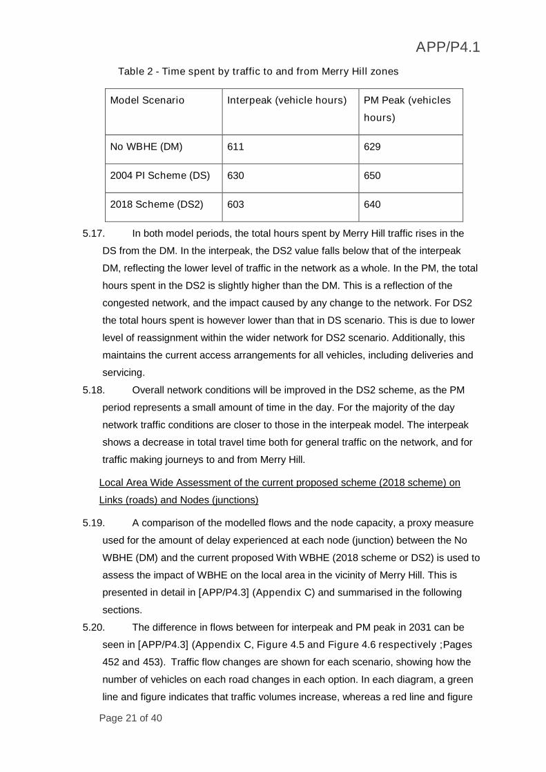
5.16. Table 2.
Page 21
APP/P4.1
Page 21 of 40
Table 2 - Time spent by traffic to and from Merry Hill zones
Model Scenario Interpeak (vehicle hours) PM Peak (vehicles
hours)
No WBHE (DM) 611 629
2004 PI Scheme (DS) 630 650
2018 Scheme (DS2) 603 640
5.17. In both model periods, the total hours spent by Merry Hill traffic rises in the
DS from the DM. In the interpeak, the DS2 value falls below that of the interpeak
DM, reflecting the lower level of traffic in the network as a whole. In the PM, the total
hours spent in the DS2 is slightly higher than the DM. This is a reflection of the
congested network, and the impact caused by any change to the network. For DS2
the total hours spent is however lower than that in DS scenario. This is due to lower
level of reassignment within the wider network for DS2 scenario. Additionally, this
maintains the current access arrangements for all vehicles, including deliveries and
servicing.
5.18. Overall network conditions will be improved in the DS2 scheme, as the PM
period represents a small amount of time in the day. For the majority of the day
network traffic conditions are closer to those in the interpeak model. The interpeak
shows a decrease in total travel time both for general traffic on the network, and for
traffic making journeys to and from Merry Hill.
Local Area Wide Assessment of the current proposed scheme (2018 scheme) on
Links (roads) and Nodes (junctions)
5.19. A comparison of the modelled flows and the node capacity, a proxy measure
used for the amount of delay experienced at each node (junction) between the No
WBHE (DM) and the current proposed With WBHE (2018 scheme or DS2) is used to
assess the impact of WBHE on the local area in the vicinity of Merry Hill. This is
presented in detail in [APP/P4.3] (Appendix C) and summarised in the following
sections.
5.20. The difference in flows between for interpeak and PM peak in 2031 can be
seen in [APP/P4.3] (Appendix C, Figure 4.5 and Figure 4.6 respectively ;Pages
452 and 453). Traffic flow changes are shown for each scenario, showing how the
number of vehicles on each road changes in each option. In each diagram, a green
line and figure indicates that traffic volumes increase, whereas a red line and figure
Page 22
APP/P4.1
Page 22 of 40
indicates that traffic volumes decrease. The width of the line indicates the magnitude
of the change, with the figure in boxes showing the numerical difference in vehicle
flow. The new signal junctions for the Metro have caused some rerouting in both
modelled time periods. In the No WBHE (DM) scenario, vehicles use Level Street
and The Embankment to access Merry Hill shopping centre. With WBHE (DS2),
some vehicles re-route via Central Way or The Boulevard due to the signal junction
at The Embankment/ Level Street. This also causes some reassignment of traffic
through the High Street/ Mill Street junction in Brierley Hill town centre and along Mill
Street.
5.21. Node capacity plots, showing the maximum volume capacity ratio (v/c) of
turns for the No WBHE (DM) and the with WBHE (DS2) for interpeak can be seen in
[APP/P4.3] (Appendix C ;Figure 5.1 and Figure 5.5 respectively Page 455.and
Page 461 respectively). The comparison between the two scenarios for key
junctions, shows that most of the junctions with WBHE in operation work within
capacity in 2031. Modelling results show that the following junctions, whilst operating
within capacity, show a slight deterioration in performance for one or more turn
movements, between the two scenarios. These junctions will continue to operate,
but with some queuing in the congested period for one of more turning movement of
traffic. These junctions are:
Level Street/ The Embankment (maximum v/c of right turn from Level
Street (West) to the Embankment changes from 53% to 91% from no
WBHE (DM) to with WBHE (DS2) scenario); and
Merry Hill/ The Boulevard (maximum v/c of right turn from Boulevard on to
Merry Hill changes from 88% to 91% from no WBHE (DM) to with WBHE
(DS2) scenario).
5.22. Similar node capacity plots, for the No WBHE (DM) and the with WBHE (DS2)
for PM peak can be seen in [APP/P4.3] (Appendix C; Figure 5.2 and Figure 5.6
respectively ;Page 456 and 463 respectively). Similar to the IP, the comparison
between the two scenarios for key junctions, shows that most of the junctions work
within capacity in 2031, with the WBHE being in operation. Modelling results show
that the following junctions in the vicinity of Merry Hill, whilst operate within capacity,
they show a slight deterioration in performance for one or more turn movements,
between the two scenarios. These junctions will continue to operate, but with some
queuing in the congested period for one of more turning movement of traffic. These
junctions are:
Page 23
APP/P4.1
Page 23 of 40
Level Street/ The Embankment (maximum v/c of north entrance from
Waterfront Way changes from 76% to 80% from no WBHE (DM) to with
WBHE (DS2) scenario);
Mill Street/ The Boulevard (maximum v/c on Mill Street southbound
approach changes from 76% to 80% and on The Boulevard northbound
approach maximum v/c changes from 78% to 82% from no WBHE (DM) to
with WBHE (DS2) scenario respectively) ;
Dudley Road/Venture Way (maximum v/c of the Dudley Road approach
changes from 92% to 99% from no WBHE (DM) to with WBHE (DS2)
scenario); and
Merry Hill/ The Boulevard (maximum v/c of right turn from Boulevard on to
Merry Hill changes from 84% to 88% from no WBHE (DM) to with WBHE
(DS2) scenario).
5.23. In summary, the assessment of the strategic impact of WBHE on the network
around Intu Merry Hill, has shown that:
i. At the local area wide level, the WBHE scheme during interpeak produces
less congestion per vehicle on the network than the no WBHE scenario.
During the PM peak, total distance falls slightly (1.1% decrease) but total
network hours rise slightly (0.8% increase). Overall the PM network is
congested as compared to the interpeak network, and therefore changes are
relatively small with similar levels of network performance in both the no
WBHE and with WBHE scenarios;
ii. The network conditions for journeys to and from the Merry Hill shopping
centre will be improved in the interpeak period and will be slightly slower in
the PM peak with WBHE scheme. Given the PM period represents a small
amount of time in the day and for the majority of the day network traffic
conditions are closer to those in the interpeak model, it is expected that
there will be an overall improvement for journeys to and from the Merry Hill;
iii. Introducing the signalised junction at Level Street/ The Embankment causes
some reassignment of traffic, with some impacts on junction performance of
three junctions in the network in the vicinity of Merry Hill;
iv. The changes to junction performance is limited to small increases in the
Volume/Capacity ratios. These junctions will still work satisfactorily
(maximum v/c being within 95% for majority of the identified junctions) but
with some queuing in congested period for one or more turning movements.
Page 24
APP/P4.1
Page 24 of 40
This is likely to be managed by optimising signal timings at these junctions
to increase the overall throughput of traffic;
v. The WBHE scheme (2018 scheme) proposals maintain access to Intu Merry
Hill for all vehicles, including car borne trips, deliveries and servicing. The
only movement that will not be possible will be the U-turn movement as with
WBHE scheme the level Street/ Embankment will be converted to a signal-
controlled junction from a roundabout. Analysis of the turn count data
presented in [APP/P4.3] (Appendix E) shows that these movements are
marginal; and
vi. The pedestrian access will be safer with provision of controlled crossing
facilities at the newly introduced traffic signals on all arms at Level Street/
The Embankment junction.
Identified Key Areas for Operational Modelling
5.24. Based on the analysis of the local area-wide impacts of WBHE there were
four junctions that were identified in the vicinity of Merry Hill, where the WBHE
scheme had an impact on the overall junction performance. These were Level
Street/ The Embankment, Mill Street/ The Boulevard, Dudley Road/Venture Way
and Merry Hill/ The Boulevard. Early engagement with Intu Merry Hill and DMBC
(email from Intu’s Technical Consultant and Dudley MBC dated 9th March 2018)
[APP/P4.3] (Appendix B), suggested that given the close proximity of these
junctions with the upstream and downstream junctions, it was important to include
additional junctions for a more detailed junction performance analysis using
microsimulation traffic modelling. This was to ensure that the interactions between
junctions was appropriately assessed.
5.25. The following nine junctions were identified for undertaking more detailed
operational modelling. These are:
a) Dudley Road/ Venture Way
b) High Street/ Level Street
c) Venture Way/ Level Street
d) The Embankment/ Level Street
e) Pedmore Road/ Level Street
f) Mill Street/ Venture Way
g) Mill Street/ The Boulevard
h) Merry Hill/ The Boulevard
i) Thorns Road (A4036)/ Mount Pleasant (A4100)
Page 25
APP/P4.1
Page 25 of 40
5.26. Further detailed assessment of the impact of WBHE on the performance of
the junctions was undertaken using microsimulation modelling. Use of
microsimulation modelling was considered to be the appropriate approach as it has
the ability to model the interaction between junctions with regards to queues
impacting the junctions upstream, which is a limitation of the isolated junction
modelling tools such as Junctions 9 and LinSig. The results of this assessment are
presented in Section 6 of my evidence.
Page 26
APP/P4.1
Page 26 of 40
6. Operational impact at the identified “key areas” for the WBHE Scheme
Key Area Transport Modelling
6.1. Microsimulation modelling using VISSIM, an industry acknowledged transport
modelling package, has been undertaken to capture the detailed impact of WBHE
on the key areas (junctions) identified and as listed in paragraph 5.25.
Microsimulation transport modelling was used to ensure that impact of any blocking
back from a junction to an upstream junction can be analysed.
6.2. As per discussions with Intu Merry Hill and Dudley MBC, MMA developed key area
transport models for three parts of the network in the vicinity of Intu Merry Hill. This
is shown in [APP/P4.3] (Appendix F (Figures 1.1, Page 488) and listed below:
i. Key Area Level Street Model – Including junctions Dudley Road/ Venture
Way, High Street/ Level Street, Venture Way/ Level Street, The
Embankment/ Level Street and Pedmore Road/ Level Street;
ii. Key Area Mill Street Model - Including junctions Mill Street/ Venture Way
and Mill Street/ The Boulevard; and
iii. Key Area Merry Hill Model - Including junctions Merry Hill/ The Boulevard
and Thorns Road (A4036)/ Mount Pleasant (A4100).
6.3. For each of the three Key Areas, the following scenarios have been developed using
VISSIM version 10.00-11 and have been built in accordance with WebTAG
guidelines for model development, calibration and validation (WebTAG Unit M3.1)
[WBHE/F25]. All three scenarios captured the interpeak period and the PM peak
period. The scenarios are listed below with further details provided in the following
sections of my evidence:
i. Base (2018) – The base model was calibrated against the traffic flow data
collected through surveys undertaken in April 2018. The model validation
was undertaken using the Traffic Master journey times and followed the
WebTAG Guidelines (WebTAG Unit M3.1 ) [WBHE/F25]. Further details
about Base (2018) model development, calibration and validation is provided
in [APP/P4.3] (Appendix F, Part A -WBHE Merry Hill Vissim Local Model
Validation Report);
ii. Do Minimum (DM) (2031) – reflects the base network but with traffic flows
forecast for 2031. The forecast traffic flows have been calculated by turning
movement from the MHL Model. Rather than assigning these flows directly,
to retain the integrity of the observed flows from April 2018 traffic surveys,
the change in traffic volumes between the base and forecast MHL Model
has been applied to the observed April 2018 flows.
Page 27
APP/P4.1
Page 27 of 40
iii. Given there is only a one year difference between the base years for MHL
Model (2017) and Key Area Vissim Models (2018), the growth between 2017
and 2031 from the MHL Model was applied to the 2018 observed flows used
in the Key Area Models. Therefore, the Key Area Models with 2018 base
year will reflect the worst-case scenario with an additional year growth in
traffic allowed for due to the MHL Model having a 2017 base year.
iv. . [APP/P4.3] (Appendix F; Part B - WBHE Merry Hill Vissim Forecast
VISSIM Modelling Report) provides further information on the methodology
used to estimate the future year flows; and
v. Do Something 2 (DS2) (2031) - As per the current proposed scheme (2018
scheme) summarised in paragraph 5.5 (iii) and traffic flows forecast for
2031.
6.4. For all the above models, 10 model runs were undertaken, and the results averaged
to ensure that the randomness in driver behaviour is reflected in the overall results.
6.5. Further details on Key Area Transport Models can be found in [APP/P4.3]
(Appendix F (Part A - WBHE Merry Hill VISSIM; Local Model Validation Report
and Part B - WBHE Merry Hill Vissim Forecast Modelling Report).
Assessment Overview
6.6. For each of the three Key Areas the modelled results for the No WBHE scenario
(DM) and With WBHE scenario (DS2), have been compared in both interpeak and
PM peak periods and presented in [APP/P4.3] (Appendix F Part B - WBHE Merry
Hill Vissim Forecast Modelling Report).
6.7. Table 3 summarises the average delay encountered by each vehicle passing
through the Key Areas modelled in both inter-peak and PM peak for the No WBHE
(DM) and with WBHE (DS2) scenarios. As can be seen for both the Level Street and
Mill Street Key Areas, there is lower or similar level of average delay per vehicle for
both time periods. For Merry Hill Key Area, whilst the average delay per vehicle is
reduced with WBHE in the PM peak, there is an increase of 23 seconds average
delay per vehicle with WBHE in the interpeak. This increase is attributed to the
reassignment of modelled traffic to Mount Pleasant (A4100) in the MHL Model.
Page 28
APP/P4.1
Page 28 of 40
Table 3 - Average Delay per vehicle in seconds (2031)
Key Area ModelsInter peak PM peak
No WBHE
(DM)
With
WBHE
(DS2)
No WBHE
(DM)
With WBHE
(DS2)
Level Street Model114 89 152 141
Mill Street Model91 92 111 98
Merry Hill Model126 149 285 238
6.8. The key results related to comparison of the modelled journey times for With (DS2)
and Without WBHE scheme (DM) for the three Key Areas by direction for both time
periods are shown in [APP/P4.3] (Appendix F ( Figures 9.1 to 9.12, Pages 529 to
535). The results show that for most of the modelled scenarios, the cumulative
journey times for with WBHE scenario (DS2) show an improvement over the without
WBHE scenario (DM) or are very similar, with the exception of Level Street Key
Area in the PM peak for eastbound direction and Merry Hill Key Area in the
interpeak for southbound direction.
6.9. The modelled journey time comparison between the With and Without WBHE (DM
and DS2) scenarios for the eastbound direction in the PM peak for Level Street Key
Area [APP/P4.3] (Appendix F (Figure 9.3), Page 530) shows that the overall
journey time has increased by 34 seconds between scenarios. This slight increase
in the overall journey times is likely to be due to a combination of introduction of
signals at the Level Street/ Embankment, changes in traffic flow pattern in the local
area (MHL Model) impacting changes in the turn movements in the Level Street Key
Area, and optimising traffic signals in the Level Street Key Area that has improved
the delays to other traffic movements at the junctions improving the overall
performance of most of the junctions. This is reflected in reduction in average delay
per vehicle in the PM peak by 11 seconds as shown in Table 3.
6.10. The modelled journey time comparison between the With and Without WBHE
(DM and DS2) scenarios for the southbound direction in the interpeak for Merry Hill
Key Area [APP/P4.3] (Appendix F (Figure 9.10, Page 534)) shows that the overall
journey time has increased by 43 seconds between scenarios. During the interpeak,
the MHL Model predicts an overall increase in traffic flows through The Boulevard
and Mount Pleasant junctions. The increase in southbound journey times are
predicted to increase predominantly due to increased traffic flows travelling to and
Page 29
APP/P4.1
Page 29 of 40
from Mount Pleasant at its junction with Merry Hill (A4036). In reality the junction will
still operate but will have slightly more delays reflected in increase in average delay
per vehicle in Table 4.
Summary
Level Street Key Area
6.11. For the Level Street Key Area, the MHL Model predicts an overall reduction in
traffic volumes as a result of reassignment to alternate routes. The reassignment is
partly due to the new Level Street/ The Embankment junction. In terms of journey
times along Level Street Key Area, this additional delay is largely mitigated by traffic
signal timing optimisation. However, travelling eastbound in the PM peak there is a
predicted increase in journey times, caused by delay at the new signals and
changes in traffic patterns. The overall highway performance analysis along Level
Street Key Area, which takes into account the side roads, demonstrates there is an
improvement with the introduction of WBHE, with reduced average delays in the
interpeak and PM peak.
Mill Street Key Area
6.12. For the Mill Street Key Area, the MHL Model predicts a small increase in
traffic volumes in both peaks. Optimised signal timings in the model at Mill Street/
Venture Way largely mitigate this impact, although there is a small three second
increase in average journey times for traffic travelling southbound in the PM peak. In
the interpeak, the overall highway performance shows the average journey time of
vehicles passing through the Key Area model increases by only one second. In the
PM peak, with WBHE scenario (DS2) is predicted to operate better than without
WBHE scenario (DM).
Merry Hill Key Area
6.13. For Merry Hill (A4036) Key Area, the MHL Model predicts an increase in
traffic in the interpeak and a decrease in the PM peak. The increase in the interpeak
is due to traffic reassigning to Mount Pleasant and results in increased southbound
journey times along Merry Hill. In the PM peak the model outputs show improved
journey times in both directions and improved overall highway performance.
Page 30
APP/P4.1
Page 30 of 40
7. Response to objectors
7.1. I have read the letters of objections and Statements of Case submitted by the
objectors to the Proposed Order and set out in this section of my Proof of Evidence
is my understanding of their points of concern and an overview and summary of how
West Midlands Combined Authority is addressing the issues raised in relation to
each concern.
7.2. I have sought to respond to the major points raised in relation to my area of
expertise, and where I am silent on any minor issues that does not mean that I
agree with the points raised in the objection.
7.3. My evidence responds to the objection raised by:
OBJ/07 Jessops Europe Limited
OBJ/10 Intu
OBJ/11 Waterstones Ltd
OBJ/15 MFG
OBJ/20 and OBJ/20/W1 McDonalds
OBJ/21 Argos Ltd
OBJ/22 and OBJ/W.1.1-1.4 TJX UK
The specific matters within the objections listed above that my evidence addresses
are:
Objection of Jessops Europe Limited (Number OBJ 07)
7.4. This objector occupies a retail unit at the Merry Hill Shopping Centre in Brierley Hill
and is concerned about the potential exercise of Order powers on two roads which
serve the shopping centre (The Embankment (plot 336)) and Central Way (plot 337))
over which it has rights of access in common with others.
7.5. The objector is concerned that WMCA has provided insufficient detail as to how
construction impacts will be mitigated and that it has no legally binding commitment
that there will be continued access along The Embankment. The extent to which The
Embankment is affected by the construction is covered in my colleague Mr. Ian
Collin’s evidence [APP/P3.1].
7.6. As stated earlier in my proof, there is no intention to permanently change the layout
or functionality of The Embankment road following the works, other than at its
junction with Level Street, which will become a permanent signalised traffic crossing,
necessary to manage the safe interaction between tram and road vehicle. The
impacts of the operation of the WBHE have been assessed using detailed transport
modelling approach which has been discussed at all stages with Intu and DMBC and
Page 31
APP/P4.1
Page 31 of 40
presented in Sections 5 and 6 of my evidence. The transport modelling has shown
no significant impacts on the highway network at this stage.
Objection of Intu (Number OBJ 10)
7.7. The objector is the owner of the Waterfront and Merry Hill Centre in Brierley Hill. The
objection is wide-ranging but states at the outset that Intu does not object to the
principle of a tram scheme serving communities around Brierley Hill and
Wednesbury.
7.8. The objection is based on grounds relating to the extent of land take, lack of
negotiation to acquire land, lack of detail relating to effects on the road network, and
insufficient information relating to environmental impact, mitigation measures,
funding and scheme design. My evidence covers the transport modelling related
concerns during the operation of WBHE, with particular concerns related to
accesses and construction covered by my colleague Mr. Ian Collins in his evidence
[APP/P3.1].
7.9. The specific concerns raised in the objection of Intu [OBJ/10], that my evidence has
addressed are related to:
i. Effect on vehicle and pedestrian movements to Merry Hill Shopping
Centre;
ii. Impact on the vehicle access to the centre from the Level Street
Roundabout with Waterfront Way South and The Embankment;
iii. Change to vehicle access routes for car borne trips to the shopping centre
as well as routing for delivery and service vehicles; and
iv. Lack of consideration given to changes to parking locations/arrangements.
Effect on vehicle and pedestrian movements to Merry Hill Shopping Centre
7.10. Detailed traffic modelling has been undertaken in response to concerns
raised by Intu during discussions with WMCA about the impacts of operation of the
WBHE. As summarised in Sections 5 and 6 of my evidence this has been
undertaken at a local area wide level and a more detailed impact on operation of
junctions in the vicinity of Merry Hill. This approach to undertaking this modelling
involved discussions with Intu and DMBC at every stage and demonstrates that the
road network in the vicinity of the Waterfront and Merry Hill Shopping Centre will
operate within capacity or no worse than in the Without WBHE scenario in the
forecast year of 2031 with any localised impacts being reduced so far as reasonably
practicable, subject to detailed design.
Page 32
APP/P4.1
Page 32 of 40
7.11. Introducing signalised junction at Level Street/ The Embankment causes
some reassignment of traffic, with some impacts on junction performance of three
junctions in the network in the vicinity of Merry Hill. However, at the local area wide
level this is balanced out by improvements elsewhere in the network.
7.12. The WBHE Scheme will enhance pedestrian access by making safe provision
of controlled pedestrian crossing facilities at the newly introduced traffic signals on
all arms at the Level Street/ The Embankment junction.
Impact on access, including accessing parking locations
7.13. There is no intention to permanently change the layout or functionality of The
Embankment road following the works, other than at its junction with Level Street,
which will become a permanent signalised traffic crossing, necessary to manage the
safe interaction between tram and road vehicle.
7.14. The vehicle access to the Merry Hill centre from Level Street roundabout with
Waterfront Way South and The Embankment will continue to be as existing. The
WBHE scheme proposals maintain access to Intu Merry Hill for all vehicles,
including car borne trips, deliveries and servicing. The only movement that will not
be possible will be the U-turn movement as the Level Street/ The Embankment as it
will be converted to a signal-controlled junction from a roundabout. Analysis of the
turn count data [APP/P4.3] (Appendix E, Pages 478 and 479) shows that these
movements are marginal, therefore having little impact on the overall access. With
WBHE in operation, no changes to access arrangements to Merry Hill parking
locations/arrangements are proposed.
7.15. Additionally, the introduction of the WBHE will provide a high-capacity, high-
quality, reliable public transport system to allow access for staff and customers to
and from Merry Hill reducing the need for travel by car.
Objection of Waterstones Booksellers Limited (Number OBJ 11)
7.16. This objector occupies two retail units at the Merry Hill Shopping Centre in
Brierley Hill and is concerned about the potential exercise of Order powers on two
roads which serve the shopping centre (The Embankment (plot 336) and Central
Way (plot 337)) over which it has rights of access in common with others.
7.17. The objector is concerned that WMCA has provided insufficient detail as to
how construction impacts on Waterstones will be mitigated and that it has no legally
binding commitment that there will be continued access along The Embankment.
The extent to which The Embankment is affected by the construction is covered in
my colleague Mr. Ian Collin’s evidence [APP/P3.1].
Page 33
APP/P4.1
Page 33 of 40
7.18. There is no intention to permanently change the layout or functionality of The
Embankment road following the works, other than at its junction with Level Street,
which will become a permanent signalised traffic crossing, necessary to manage the
safe interaction between tram and road vehicle. The impacts of the operation of the
WBHE have been assessed using detailed transport modelling approach which has
been discussed at all stages with Intu and Dudley MBC and presented in Sections 5
and 6 of my evidence. The transport modelling has shown no significant impacts on
the highway network at this stage.
Objection of MFG (Number OBJ 15)
7.19. The objection is made by the previous owner of the property, Malthurst, and
maintained by MFG relating to concerns that the WBHE will have an adverse impact
on the Merry Hill Service Station and any other property owned by MFG in the
vicinity that will be directly or indirectly affected by the scheme.
7.20. Malthurst Group was served in respect of plot 336 (The Embankment), which
is a private road. The Proposed Order would authorise WMCA to permanently
acquire The Embankment and to acquire rights over Central Way in common with
existing users.
7.21. Since the objection was lodged the property has been sold. Despite seeking
confirmation of the new owner’s identity and agents from Malthurst’s agent, this was
only provided on 6 December 2018 and WMCA is now in contact with the agent for
the new owner, MFG.
7.22. Plot 336 includes land as well as The Embankment road and it is intended
that a tram stop will be constructed at this location. Following its temporary use for
construction The Embankment will be reinstated as a two-way access road for all
traffic.
7.23. The extent to which The Embankment is affected by the construction of the
WBHE will be reduced so far as reasonably practicable, subject to detailed design,
but this is one of a number of routes available to the property. This has been
covered in my colleague Mr. Ian Collin’s evidence [APP/P3.1].
7.24. There is no intention to permanently change the layout or functionality of The
Embankment road following the works, other than at its junction with Level Street,
which will become a permanent signalised traffic crossing, necessary to manage the
safe interaction between tram and road vehicle. The impacts of the operation of the
WBHE have been assessed using detailed transport modelling approach which has
been discussed at all stages with Intu and DMBC and presented in Sections 5 and 6
Page 34
APP/P4.1
Page 34 of 40
of my evidence. The transport modelling has shown no significant impacts on the
highway network at this stage.
Objection of McDonalds (Number OBJ 20 and OBJ/20/W1)
7.25. This objection is on behalf of McDonalds and its franchisees, Astrad Limited
and AR Sirkhat. The objector occupies two units at the Merry Hill Shopping Centre.
It is concerned about the impacts of the scheme and sought assurances regarding
access over plots 336 and 337 (The Embankment and Central Way) in Brierley Hill.
7.26. The extent to which The Embankment is affected by the construction and
operation of the WBHE will be reduced so far as reasonably practicable, subject to
detailed design, but this is one of a number of routes available to the objector and its
customers to gain access to and egress from the Merry Hill Shopping Centre.
7.27. There is no intention to permanently change the layout or functionality of The
Embankment road following the works, other than at its junction with Level Street,
which will become a permanent signalised traffic crossing, necessary to manage the
safe interaction between tram and road vehicle. The impacts of the operation of the
WBHE have been assessed using detailed transport modelling approach which has
been discussed at all stages with Intu and Dudley MBC and presented in Sections 5
and 6 of my evidence. The transport modelling has shown no significant impacts on
the highway network at this stage.
Objection of Argos Limited (Number OBJ 21)
7.28. This objector occupies a unit at the Merry Hill Shopping Centre in Brierley Hill.
It is concerned about the impacts of the scheme, and sought assurances regarding
access over plots 336 and 337 (The Embankment and Central Way) in Brierley Hill
7.29. The extent to which the Embankment is affected by the construction and
operation of the WBHE will be reduced so far as reasonably practicable, subject to
detailed design, but this one of a number of routes available to the objector and its
customers to gain access to and egress from the Merry Hill Shopping Centre.
WMCA has been and will continue to work closely with Dudley Council and Intu to
minimise disruption during construction of the WBHE.
7.30. There is no intention to permanently change the layout or functionality of The
Embankment road following the works, other than at its junction with Level Street,
which will become a permanent signalised traffic crossing, necessary to manage the
safe interaction between tram and road vehicle. The impacts of the operation of the
WBHE have been assessed using detailed transport modelling approach which has
been discussed at all stages with Intu and Dudley MBC and presented in Sections 5
Page 35
APP/P4.1
Page 35 of 40
and 6 of my evidence. The transport modelling has shown no significant impacts on
the highway network at this stage.
Objection of TJX UK (trading as TK Maxx) (Number OBJ/22 and OBJ/W.1.1-1.4)
7.31. This objector occupies a unit at the Merry Hill Shopping Centre in Brierley Hill.
It is concerned about the impacts of the scheme and sought assurances regarding
access over plots 336 and 337 (The Embankment and Central Way) in Brierley Hill.
7.32. The extent to which The Embankment is affected by the construction and
operation of the WBHE will be reduced so far as reasonably practicable, subject to
detailed design, but this is one of a number of routes available to the objector and its
customers to gain access to and egress from the Merry Hill Shopping Centre.
WMCA has been and will continue to work closely with Dudley Council and Intu to
minimise disruption during construction of the WBHE.
7.33. There is no intention to permanently change the layout or functionality of The
Embankment road following the works, other than at its junction with Level Street,
which will become a permanent signalised traffic crossing, necessary to manage the
safe interaction between tram and road vehicle. The impacts of the operation of the
WBHE have been assessed using detailed transport modelling approach which has
been discussed at all stages with Intu and Dudley MBC and presented in Sections 5
and 6 of my evidence. The transport modelling has shown no significant impacts on
the highway network at this stage.
Page 36
APP/P4.1
Page 36 of 40
8. Summary and Conclusions
Scope, including Statement of Matters and Objections
8.1. My evidence covers the transport modelling undertaken to understand the impacts
of the operation of the WBHE on the local road network, including impact on
highway network in the vicinity of Merry Hill Shopping Centre and on Churchill
Shopping Centre in Dudley Town Centre.
8.2. I deal in my evidence with the following matters in the Statement of Matters issued
by the Secretary of State for Transport [GEN/3].
Matter 4(a) the impacts on access to and within the area, including the
effects on local road networks, access to businesses and car parks, and
access by emergency vehicles; and
Matter 4 (c) the impacts on members of the general public, including users
of the Churchill Shopping Centre in Dudley and the Merry Hill Shopping
Centre in Brierley Hill.
8.3. With regards to the above Matters my evidence covers the impact of the operation of
WBHE.
8.4. This evidence addresses the objections OBJ 07 Jessops Limited (Number; OBJ/10
Intu; OBJ/11 Waterstones Booksellers Ltd.; OBJ/15 MFG; OBJ/20 McDonalds
Restaurants Limited and Astrad Limited and AR Sirkhat; OBJ/21 Argos Ltd; and
OBJ/22 TJX UK (trading as TK Maxx).
Overview of Transport Modelling Approach
8.5. Junction capacity assessment work undertaken by Mott MacDonald in 2016
[WBHE/F20] and updated by MMA in 2018 [APP/P4.3](Appendix A), has formed
the basis of assessing the impact of WBHE on the local road network,
8.6. The impacts of the operation of the WBHE in the vicinity of Merry Hill, have been
assessed using detailed transport modelling approach presented in sections 5 and
6 of my evidence). This included assessing the local area wide impact using Merry
Hill Local Model and more detailed impact on junctions and roads in three Key Areas
including Level Street, Mill Street and Merry Hill, using micro-simulation modelling.
Impact of WBHE on the local road network
8.7. Section 4 of my evidence summarises the impact of WBHE on the local road
network. Junction Capacity Assessment, using industry standard software has
informed this assessment. This was for one-hour time periods for AM peak, PM
Peak and Saturday peak by comparing the with and without WBHE scheme for
forecast years 2021 and 2031.
8.8. The junction capacity assessment predicts that all junctions assessed bar Castle Hill
/ Trindle Road / Station Approach are predicted to operate within capacity in 2021
Page 37
APP/P4.1
Page 37 of 40
and 2031. This junction only shows a slight exceedance of capacity in the 2031 AM
peak period. it should be noted that the forecast traffic flows does not take account
of modal shift as a result of Metro or the redistribution of traffic associated with
Dudley Interchange and Portersfield. These changes when considered may result in
a lower volume of traffic on Castle Hill and are likely to result in better junction
performance than that indicated by the model outputs in all time periods including
the 2031 AM Peak period with WBHE.
Impact of WBHE on the highway network around Merry Hill
8.9. Following discussions with DMBC and Intu, a local model of the Merry Hill area,
known as the Merry Hill Local Model (MHL model) was developed from the West
Midlands-wide strategic PRISM model. Impact on the local area was assessed for
interpeak and PM peak for 2031 using the MHL model for with and without WBHE
scheme scenarios.
8.10. The assessment of the local area wide impact of WBHE on the network
around Intu Merry Hill, has shown that:
At the local area wide level, the WBHE scheme during interpeak produces
less congestion per vehicle on the network than the Without WBHE scenario.
Overall the PM network is congested as compared to the Interpeak network ,
and therefore changes are relatively small with similar levels of network
performance in both the no WBHE and with WBHE scenarios;
The network conditions for the journeys to and from Merry Hill shopping
centre will be improved in the interpeak period and will be slightly slower in
the PM peak with WBHE scheme. Given for the majority of the day network
traffic conditions are closer to those in the interpeak model, it is expected that
there will be an overall improvement for journeys to and from Merry Hill; and
Introducing signalised junction at Level Street/The Embankment causes some
reassignment of traffic, with some impacts on junction performance of four
junctions including Level Street/ The Embankment, Mill Street/ The Boulevard,
Dudley Road/Venture Way and Merry Hill/ The Boulevard. These junctions will
still work satisfactorily but with some queuing in congested period for one or
more turning movements, which is likely to be managed by optimising signal
timings at these junctions to increase the overall throughput of the junctions.
Operational impact at the identified “Key Areas” for the WBHE Scheme
8.11. Based on the analysis of the local area wide impacts of WBHE and in
discussions with Intu and DMBC, three “Key Areas”, identified for detailed
microsimulation modelling, included Level Street (between Dudley Road/Venture
Page 38
APP/P4.1
Page 38 of 40
Way and Pedmore Road); Mill Street (between Venture way and The Boulevard);
and Merry Hill (between Coppice Lane and Mount Pleasant).
8.12. Vissim micro-simulation software was used to assess the impact for interpeak
and PM peak for 2031 for without WBHE and WBHE scheme scenarios. The
assessment shows:
For the Level Street Key Area, the overall highway performance along Level
Street Key Area, including the side roads, shows an improvement with the
introduction of WBHE, with reduced average delays in the interpeak and PM
peak. The new Level Street / The Embankment signalised junction, introduces
some additional delay, which is largely mitigated by traffic signal timing
optimisation. Travelling eastbound in the PM peak there is predicted to be
slight increase in the overall journey times, caused by delay at the new
signals and changes in traffic patterns;
For the Mill Street Key Area, the MHL Model predicts a small increase in
traffic volumes in both peaks. The assessment shows an improvement in the
PM peak, with lower average delay per vehicle. In the interpeak, the average
journey time of vehicles passing through the Key Area model increases by
one second, showing minimal impact on this Key Area; and
For Merry Hill (A4036) Key Area, the MHL Model predicts an increase in
traffic in the interpeak due to traffic reassigning to Mount Pleasant and results
in increased southbound journey times along Merry Hill. In the PM peak the
MHL model predicts a decrease in traffic with improved journey times in both
directions and improved overall highway performance.
Response to objectors
Objection of Jessops Limited (Number OBJ 07)
8.13. The impacts of the operation of the WBHE have been assessed using
detailed transport modelling with no significant impacts predicted.
Objection of Intu (Number OBJ 10)
8.14. Detailed traffic modelling has been undertaken in response to concerns
raised by Intu during discussions with WMCA about the impacts of operation of the
WBHE. As summarised in sections 5 and 6 of my evidence this has been
undertaken at local area wide and more detailed junction operation level in the
vicinity of Merry Hill. This approach to modelling involved discussions with Intu and
DMBC and demonstrates that the road network in the vicinity of Merry Hill Shopping
Centre will operate within capacity or not be significantly worse than the Without
WBHE scenario in the forecast year of 2031.
Page 39
APP/P4.1
Page 39 of 40
8.15. There is no intention to change The Embankment road permanently, other
than at its junction with Level Street. The current access arrangement to Intu Merry
Hill for all vehicles, including car trips, deliveries and servicing will remain the same.
The only exception is U-Turn movements as with WBHE Scheme, junction will be
converted to signal-control. These movements are marginal as confirmed by the
traffic surveys.
8.16. The pedestrian access will be safer with provision of controlled crossing
facilities at the new traffic signals at Level Street/The Embankment junction.
Objection of Waterstones Booksellers Limited (Number OBJ 11)
8.17. The impacts of the operation of the WBHE have been assessed using
detailed transport modelling with no significant impacts predicted.
Objection of MFG (Number OBJ 15)
8.18. The impacts of the operation of the WBHE have been assessed using
detailed transport modelling with no significant impacts predicted.
Objection of McDonalds (Number OBJ 20 and OBJ/20/W1)
8.19. The impacts of the operation of the WBHE have been assessed using
detailed transport modelling with no significant impacts predicted.
Objection of Argos Limited (Number OBJ 21)
8.20. The impacts of the operation of the WBHE have been assessed using
detailed transport modelling with no significant impacts predicted.
9. Objection of TJX UK (trading as TK Maxx) (Number OBJ/22 and OBJ/W.1.1-1.4)
9.1. The impacts of the operation of the WBHE have been assessed using detailed
transport modelling with no significant impacts predicted.
Conclusion
9.2. The need for the land and rights proposed to be acquired has been fully justified.
9.3. Funding is available and the project is ready to proceed, and I urge the Inspector to
recommend the powers applied for.
Page 40
APP/P4.1
Page 40 of 40
Paragraph Ref Appendix Description
2.5, 4.2, 4.4,
4.6, 4.7 and 8.5
A WBHE Junction Capacity Assessment Update; MMA January 2019
2.12, 5.1 and
5.23
B Engagement with Intu Merry Hill and Dudley MBC
2.13, 2.17, 5.2,
5.7, 5.15, 5.18,
5.19, 5.20 and
5.21
C WBHE Merry Hill Local Model Traffic Modelling Report
5.4 D Automatic Traffic Count Data Analysis to reconfirm the network peak
5.22 E Analysis of the U-Turning Traffic at Level Street/The Embankment
6.2, 6.3, 6.5,
6.6, 6.8, 6.9 and
6.10
F WBHE VISSIM Model Reports Part A– Local Model Validation
Report; and Part B - Model Forecasting Report