INVESTING IN THE A40 www.oxfordshire.gov.uk/connectingoxfordshire Welcome to the exhibition The A40 is used by over 30,000 vehicles each day and is the main route linking the M40, Oxford, Cheltenham and South Wales. This exhibition puts a spotlight on the A40 corridor. It sets out both what we are doing now to improve journeys for people and businesses who rely on this route, and why we need to attract further investment. We have set out a range of options for the long-term future of the A40 corridor, including possibilities for buses, cars, trains and trams. We need your views on these options now, so that we can be ready to bid for future funding opportunities from government as they arise. If you have any questions as you go round, please talk to a member of the project team who are here to help. OXFORD Eynsham Ducklington Yarnton Cassington Botley A40 A44 A420 B4044 B4449 B4449 A415 A4095 A34 A34 A34 B4022 WITNEY Kennin Cu Wolvercote Gosford A40 Long Hanborough
Transcript
INVESTING IN THE A40
www.oxfordshire.gov.uk/connectingoxfordshire
Welcome to the exhibition
The A40 is used by over 30,000 vehicles each day and is the main route linking the M40, Oxford, Cheltenham and South Wales.
This exhibition puts a spotlight on the A40 corridor. It sets out both what we are doing now to improve journeys for people and businesses who rely on this route, and why we need to attract further investment.
We have set out a range of options for the long-term future of the A40 corridor, including possibilities for buses, cars, trains and trams. We need your views on these options now, so that we can be ready to bid for future funding opportunities from government as they arise.
If you have any questions as you go round, please talk to a member of the project team who are here to help.
OXFORD
Eynsham
Ducklington
MinsterLovell
BrizeNorton
Carterton
Yarnton
Cassington
Botley
Littlemore
A40
A40
A44
A420
B4044
B4449
B4449
A415
A4095
A34
A34
A34
B4022
B4477
WITNEY
Kennington
Headington
Summertown
Barton
Marston
Cowley
Cutteslowe
Wolvercote
Gosford
Risinghurst
A40
A40
New Headington
LongHanborough
www.oxfordshire.gov.uk/connectingoxfordshire
BACKGROUND
Oxfordshire is a prosperous and vibrant county, combining a successful, thriving economy with a high quality environment. Current forecasts are for over 85,000 new jobs and 100,000 new homes in the county by 2031.
This growth will have a significant impact on our transport network, with an ever increasing number of people and goods needing to use it. We cannot simply rely on small, short-term solutions; more radical solutions are required.
Connecting Oxfordshire, our new Local Transport Plan, was agreed in September. The key objectives of Connecting Oxfordshire are to:
• Support jobs and housing growth and economic vitality; • Reduce transport emissions and meet our obligations to Government; • Protect, and where possible enhance Oxfordshire’s environment and improve quality of life; and • Improve public health, air quality, safety and individual wellbeing.
Why we need to improve the A40
The A40 is a single carriageway road and on the section between Witney and Oxford, between 23,000 and 30,000 vehicles currently use it each day, which is above the road’s capacity.
Congestion on the road causes daily problems for road users and has been described by business leaders as one of the biggest barriers to economic growth and prosperity in West Oxfordshire.
The quality of life for residents, and future economic prosperity of this part of Oxfordshire - key objectives for our Local Transport Plan - are threatened unless a suitable, long-term solution for the A40 corridor is found.
This solution is likely to involve a combination of road and a public transport improvements.
www.oxfordshire.gov.uk/connectingoxfordshire
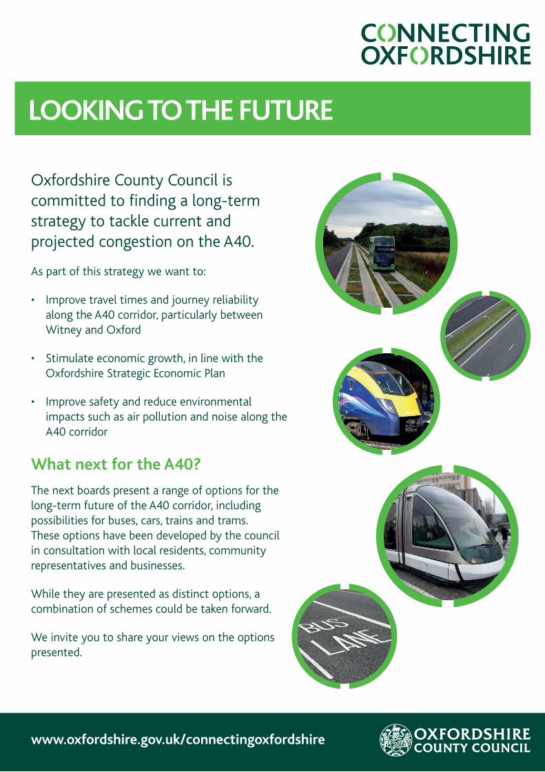
Oxfordshire County Council is committed to finding a long-term strategy to tackle current and projected congestion on the A40.
As part of this strategy we want to:
• Improve travel times and journey reliability along the A40 corridor, particularly between Witney and Oxford
• Stimulate economic growth, in line with the Oxfordshire Strategic Economic Plan
• Improve safety and reduce environmental impacts such as air pollution and noise along the A40 corridor
What next for the A40?
The next boards present a range of options for the long-term future of the A40 corridor, including possibilities for buses, cars, trains and trams. These options have been developed by the council in consultation with local residents, community representatives and businesses.
While they are presented as distinct options, a combination of schemes could be taken forward.
We invite you to share your views on the options presented.
LOOKING TO THE FUTURE
www.oxfordshire.gov.uk/connectingoxfordshire
The diagram below shows a snapshot of car journeys travelling eastbound along the A40 between Cassington and Wolvercote during the morning peak.
WHO USES THE A40?
Bucks
London
Oxford
Berks
South Oxfordshire
South East
A40
DESTINATION OF JOURNEYORIGIN OF JOURNEY
3%
9%
72%
<1%
14%
2%
Bristol, Bath & Avon
Devon & Cornwall
Glocs
Wales
West Oxfordshire
Wilts
<1%
<1%
6%
1%
91%
2%
E
Although the A40 is a strategically important road, most of the peak time traffic is locally based. Although there is a higher than average proportion of light goods vehicles and lorries, the road is still dominated by cars and vans.
Light goods vehicles (14%)
Lorries (9%)
Buses (1%)
Cycles (<1%)
Motorcycle (1%)
Cars and vans (75%)
OXFORD
Eynsham
Ducklington
MinsterLovell
BrizeNorton
Carterton
Yarnton
Cassington
Botley
Littlemore
A40
A40
A44
A420
B4044
B4449
B4449
A415
A4095
A34
A34
A34
B4022
B4477
WITNEY
Kennington
Headington
Summertown
Barton
Marston
Cowley
Cutteslowe
Wolvercote
Gosford
Risinghurst
A40
A40
New Headington
LongHanborough
GG H
JL
K M
N
O P
Q
I
FG
E
A
A E H K
L
M
N
O
P
Q
I
J
F
G
B
B
C
D
C
D
TO LONDON
TO BIRMINGHAM
TO CHELTENHAM
TO NEWBURY
Local Growth Fund Scheme: A40 Science Transit Highlighted points F – I are a new scheme to deliver £36 million of improvements. This was agreed by Cabinet in July 2015. Work to develop these schemes will take place over the next 12 months.
AGREED INVESTMENT IN THE A40 UP TO 2025
Access to Carterton Improvements to the B4477 and
western facing slips on the A40 at Minster Lovell – subject to funding
Access to Witney – Downs Road New junction at Grade roundabout
Access to Witney – Ducklington Lane Junction capacity and safety
improvements at junction with Duckington Lane and Station Lane – completed in 2014
Access to Witney – Shore’s Green New western facing slips at
Shore’s Green
Hanborough Station First Great Western has applied for funding to expand the car park, provide a bus/rail interchange and improve passenger facilities at Hanborough Station
A40 Park & Ride New A40 Park & Ride (location to
be determined)
A40 Junction Improvements Junction improvements to A40 at
Eynsham and Cassington – part of Local Growth Fund Scheme
A40 Bus Lane New bus priority measures – part
of Local Growth Fund Scheme
Bus Priority at the Swinford Toll Bridge New bus priority scheme on Oxford bound approaches to Swinford Toll Bridge, Eynsham – part of Local Growth Fund scheme
A40-A44 Strategic Link Road New road linking A40-A44,
bypassing Wolvercote roundabout and providing a link to the A34 and Oxford Parkway Station from West Oxfordshire
Northern Gateway Site Link Road and A40/A44 Junctions New infrastructure to access development and also provide a more direct link to Peartree Park & Ride and A34
Oxford Parkway Station New rail station next to Water Eaton
Park & Ride providing direct rail links between Oxford and London Marylebone – opening autumn 2015
Cutteslowe & Wolvercote Roundabouts Junction improvements to Cutteslowe and Wolvercote roundabouts – work starts summer 2015
Access to Headington Scheme Junction and road improvements
to reduce congestion and improve access to the hospitals in Headington
Headington Roundabout New bus priority measures –
completed March 2015
Expansion of Thornhill Park & Ride Car parking capacity increased by 500 spaces, new A40/London Road bus priority and cycle improvements – completed summer 2013
A34 Improvements Highways England is planning improvements to the Peartree and Botley interchanges and improved driver information on the Trunk Road by the end of 2019/20. The A34 around Oxford is included in the wider Oxford-Cambridge Expressway study, which could reduce pressures on A40 by providing an alternative route for some trips
www.oxfordshire.gov.uk/connectingoxfordshire
A40 BUS LANE
YARNTON
LONG HANBOROUGH
CASSINGTON
EYNSHAM
STANTONHARCOURT
WITNEY
MINSTER LOVELL
FREELAND
KIDLINGTON
BOTLEY
A40
A34
A40
A415 A420 A34A4095
DUCKLINGTONOXFORD
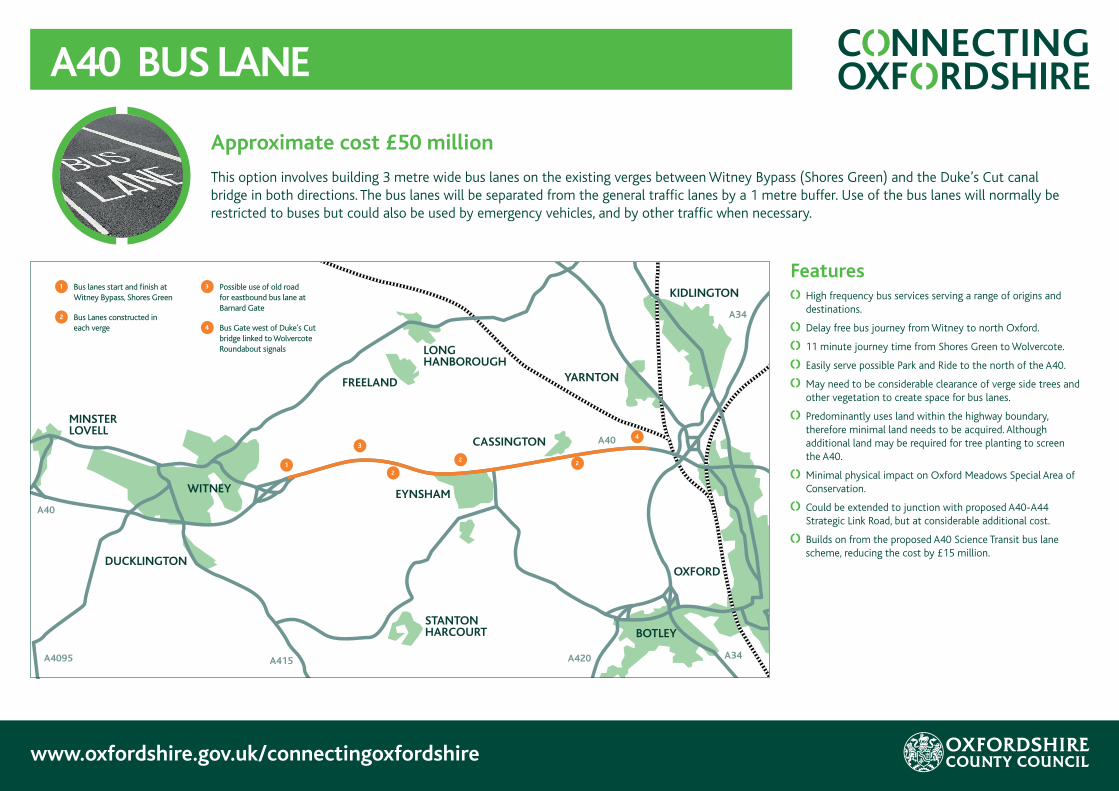
1 Bus lanes start and finish at Witney Bypass, Shores Green
2 Bus Lanes constructed in each verge
3 Possible use of old road for eastbound bus lane at Barnard Gate
4 Bus Gate west of Duke’s Cut bridge linked to Wolvercote Roundabout signals
1
3
2
22
4
Features
High frequency bus services serving a range of origins and destinations.
Delay free bus journey from Witney to north Oxford.
11 minute journey time from Shores Green to Wolvercote.
Easily serve possible Park and Ride to the north of the A40.
May need to be considerable clearance of verge side trees and other vegetation to create space for bus lanes.
Predominantly uses land within the highway boundary, therefore minimal land needs to be acquired. Although additional land may be required for tree planting to screen the A40.
Minimal physical impact on Oxford Meadows Special Area of Conservation.
Could be extended to junction with proposed A40-A44 Strategic Link Road, but at considerable additional cost.
Builds on from the proposed A40 Science Transit bus lane scheme, reducing the cost by £15 million.
Approximate cost £50 million
This option involves building 3 metre wide bus lanes on the existing verges between Witney Bypass (Shores Green) and the Duke’s Cut canal bridge in both directions. The bus lanes will be separated from the general traffic lanes by a 1 metre buffer. Use of the bus lanes will normally be restricted to buses but could also be used by emergency vehicles, and by other traffic when necessary.
www.oxfordshire.gov.uk/connectingoxfordshire
GUIDED BUSWAY
Approximate cost £165 million
This option involves installing a two-way guided busway track to provide a new route from Witney to Oxford using specially adapted buses. The proposed route would use the line of the old railway from Witney to Cassington, except in Eynsham where buses would use the roads through the village. The route would continue with a guided busway alongside A40 to Duke’s Cut canal bridge.
Features
High or Medium frequency buses serving a wide range of origins and destinations
Time savings of up to 15 minutes for guided bus users at peak times from Witney to Oxford.
12 minute journey time from Ducklington to Wolvercote.
Use of old railway corridor would require considerable land acquisition.
May need to be considerable clearance of verge side trees and other vegetation to create space for guided busway on the A40
Probably impact on the vegetation, wildlife habitat and land uses along the line of the old railway.
Cost does not included widening or replacing the existing railway and canal bridges at Duke’s Cut, where buses will merge into the general traffic lane.
Should be minimal physical impact on Oxford Meadows Special Area of Conservation.
A guided busway uses new track provided for the exclusive use of compatible buses. Buses are specially adapted to use the busway but can also use ordinary roads.
YARNTON
LONG HANBOROUGH
CASSINGTON
EYNSHAM
STANTONHARCOURT
WITNEY
MINSTER LOVELL
FREELAND
KIDLINGTON
BOTLEY
A40
A34
A40
A415 A420 A34A4095
DUCKLINGTONOXFORD
1 Busway starts at Ducklington Roundabout
2 New alignment from Ducklington to South Leigh
3 Busway diverted around South Leigh to join old railway alignment
4 Busway on line of old railway
5 Busway terminates at Station Road and buses travel on street through village to Swinford Roundabout
6 Busways built in verges Cassington to Duke’s Cut Bridge
7 Busway ends at Bus Gate west of Duke’s Cut Bridge
1 3
2
5
6 7
4
4
www.oxfordshire.gov.uk/connectingoxfordshire
A40 DUAL CARRIAGEWAY
Features
Dual Carriageway benefits both freight and passenger vehicles (buses, cars, lorries etc.).
Estimated journey times (without delays inc. at North Oxford junctions) of 3 minutes from Eynsham to Wolvercote roundabout and 7 minutes from Witney to Wolvercote.
No priority for buses and removal of A40 Science Transit bus lane scheme.
Could easily serve possible Park and Ride to the north of the A40 at Eynsham, although no bus lanes would limit the appeal to users.
May need to be considerable clearance of verge side trees and other vegetation to create space for dual carriageway.
Possible adverse impact of Oxford Meadows Special Area of Conservation due to potential encroachment on protected land.
Considerable land acquisition needed along the length of the route, for both widening and junctions, particularly if the alternative Eynsham bypass is pursued.
May require an additional ‘North Oxford’ bypass to provide a high standard through route. Would require an additional £100+ million investment.
May encourage additional car trips to Oxford which would require extra parking to be provided within the city.
May encourage traffic growth which could reduce benefits of dual carriageway in future years.
YARNTON
LONG HANBOROUGH
CASSINGTON
EYNSHAM
STANTONHARCOURT
WITNEY
MINSTER LOVELL
FREELAND
KIDLINGTON
BOTLEY
A40
A34
A40
A415 A420 A34A4095
DUCKLINGTONOXFORD
1 New dual carriageway starts at end of Witney Bypass, Shores Green
2 Existing route widened to 2-lane, dual carriageway road
3 Side road accesses around Barnard Gate brought together in single junction
4 Alternative on-line or bypass route options for Eynsham
5 Existing Cassington traffic lights removed, new link road built with roundabout east of village
6 Link road to new junction on A40-A44 Strategic Link Road
7 Additional ‘North Oxford’ bypass may be required - route to be determined
1
3
2 4 2
5
2
6
Approximate cost £120 million Additional £100 million may be required for ‘North Oxford’ bypass
This option involves widening the A40 to 2-lanes in each direction separated by a central reservation barrier. The A40 Dual Carriageway would follow the existing road and would require significant alterations to junctions at Barnard Gate and Cassington to provide safe access. The Dual Carriageway central reserve would prevent certain movements and restrict direct access in some cases.
7
YARNTON
LONG HANBOROUGH
EYNSHAM
STANTONHARCOURT
WITNEY
MINSTER LOVELL
FREELAND
KIDLINGTON
BOTLEY
A40
A34
A40
A415 A420 A34A4095
DUCKLINGTONOXFORD
CASSINGTON
1 New Station in vicinity of Ducklington Roundabout
2 New line between Ducklington and South Leigh
3 Line diverted around South Leigh
4 Use previous alignment (South Leigh to west of Eynsham, east of Eynsham –Yarnton Jn)
5 New line built between village and bypass, including new station and bridges over/under eastern bypass and Station Road
6 Reinstate Yarnton Junction, trams carry on to Oxford Station
1
3
2
5
6
4
4
4
www.oxfordshire.gov.uk/connectingoxfordshire
WITNEY – OXFORD TRAIN
Approximate cost £285 million
This option involves building a new single-track railway line, with double track running through stations providing two platforms and allowing the opportunity for trains to pass each other. Trains are likely to be diesel powered. Trains would run from south of Ducklington roundabout to join the line of the old railway near South Leigh, then pass between Eynsham and B4449 before joining the Cotswold Line at Yarnton, where trains would carry on to Oxford Station.
Features
Journey time from Witney to Oxford approximately 17 minutes.
Single track would only allow up to 1-2 trains per hour in each direction, due to limited opportunities to pass each other.
Stations would require adequate car parking to act as Parkways.
Would require considerable land acquisition, including through Cassington Quarry.
There will be an impact on the vegetation, wildlife habitat and landuses along the route.
Trains could be extended run from Oxford Station to Littlemore and Cowley using Cowley Branch Line for passenger services.
Provides bus connections at Oxford Station to wider range of local destinations, and access to national rail network.
Bridges needed to avoid building level crossings on Station Road, Eynsham and B4449 Eynsham bypass road; line would need to be diverted to avoid impacts in South Leigh.
The railway lines through Oxford may not have sufficient spare capacity to allow more frequent services to run.
Proposal needs to be economically viable for Network Rail and a Train Operating Company.
Possibility that an alternate route (shown in red) could run north of A40, from near Oxford Hill at Witney to Yarnton. This would cost a similar amount and may be less disruptive to build; but it would however preclude any future extension to Carterton.
www.oxfordshire.gov.uk/connectingoxfordshire
WITNEY - OXFORD TRAM
Approximate cost £240 million
New double track, light rail line linking from south of Ducklington roundabout to the old railway line at South Leigh then using the railway alignment to Eynsham, where a new line would be created between the village and the southern bypass. From close to Siemens the line would follow the old railway line to A40. At the A40 the line would either continue to a railway junction at Yarnton, if a joint tram-train operation was permitted, or continue alongside the A40 toward Oxford.
Features
Journey times from Witney to Oxford 20-25 minutes.
Double track allows 4 trams per hour in each direction but the railway lines through Oxford may not have sufficient spare capacity to allow such frequent services to run.
Tram stops would require adequate car parking to act as Parkways.
Would require considerable land acquisition, including through Cassington Quarry.
There will be an impact on the vegetation, wildlife habitats and land uses along the route.
The railway authorities may not permit joint tram-train operation, as this would be the first in the UK.
An alternative route would be along the A40, but this would require either a terminus to be provided in north Oxford, or on-street running to Oxford City Centre at considerable extra costs (£100m+).
Provides connections to local bus services at Oxford Station and access to national rail network.
Proposal needs to be economically viable for operating company.
YARNTON
LONG HANBOROUGH
CASSINGTON
EYNSHAM
STANTONHARCOURT
WITNEY
MINSTER LOVELL
FREELAND
KIDLINGTON
BOTLEY
A40
A34
A40
A415 A420 A34A4095
DUCKLINGTONOXFORD
1 New station in vicinity of Ducklington roundabout
2 New line between Ducklington and South Leigh
3 Divert line around South Leigh
4 Use old railway line alignment (South Leigh to west of Eynsham, east of Eynsham –A40)
5 New line built between village and bypass
6 Use old railway (A40 – Yarnton junction) if shared use permitted, otherwise construct tracks alongside A40 including new bridges over railway and canals
7 Reinstate Yarnton junction if shared use permitted
8 Need to consider on-street running in Witney, Eynsham and north Oxford
1 3
2
4
8
5 4
6
7
8
www.oxfordshire.gov.uk/connectingoxfordshire
NEXT STEPS
Thank you for coming to the exhibition.
Have your say
Please give us your views. Either:
• Fill in a copy of the consultation feedback form that is available at this exhibition and post it in the box provided
• Read a copy of the proposals online and fill in the survey form at www.oxfordshire.gov.uk/A40
The deadline for giving your views is Sunday 8 November.
What happens next?
The feedback from this consultation will inform a discussion by Oxfordshire County Council’s Cabinet in spring 2016 on the long-term strategy for the A40. This will put the council in a strong position so that we can move quickly with a bid for government funding when opportunities arise.
In the meantime, we will be developing our ideas for the Local Growth Fund Scheme – A40 Science Transit and we expect to be able to share these proposals in autumn 2016.