96
ON THE GROUND: 40B Developments Before and After Tufts University DeGenova I Goodwin I Moriarty I Robitaille

ON THE GROUND:40B Developments Before and After
Tufts UniversityDeGenova I Goodwin I Moriarty I Robitaille


Prepared by: Alexandra DeGenova I Brendan Goodwin I Shannon Moriarty I Jeremy Robitaille
Tufts University I Urban and Environmental Policy and Planning I Field Projects
Prepared for: Citizens’ Housing and Planning Association I May 1, 2009
ON THE GROUND: 40B Controversies Before and After
ON THE GROUND:40B Developments Before and After
School of Artsand Sciences

Table of ContentsAcknowledgements
AbstractExecutive Summary
Chapter 1: Project OverviewStudy Hypothesis
40B Leislation OverviewControversiesMethodology
Chapter 2: WalpoleCommunity Profile
The PreserveOn the Ground: Before
On the Ground: AfterWalpole Conclusion
Chapter 3: NewtonCommunity Profile
The Kayla’s House DevelopmentOn the Ground: Before
On the Ground: AfterNewton Conclusion
Chapter 4: WellesleyCommunity Profile
Hastings VillageOn the Ground: Before
On the Ground: AfterWellesley Conclusion
Chapter 5: WestonCommunity Profile
Dickson MeadowOn the Ground: Before

i ON THE GROUND: 40B Controversies Before and After
Table of ContentsTable of Contents
AcknowledgementsAbstract
Executive Summary
Chapter 1: Project OverviewStudy Hypothesis
40B Leislation OverviewControversiesMethodology
Chapter 2: WalpoleCommunity Profile
The PreserveOn the Ground: Before
On the Ground: AfterWalpole Conclusion
Chapter 3: NewtonCommunity Profile
The Kayla’s House DevelopmentOn the Ground: Before
On the Ground: AfterNewton Conclusion
Chapter 4: WellesleyCommunity Profile
Hastings VillageOn the Ground: Before
On the Ground: AfterWellesley Conclusion
Chapter 5: WestonCommunity Profile
Dickson MeadowOn the Ground: Before
iiiiivv
11123
9910111318
212121222731
353536384447
51515152

ii ON THE GROUND: 40B Controversies Before and After
Table of Contents
Chapter 5: Weston On the Ground: After
Weston ConclusionConclusion
AppendicesAppendix A: HAC Review
Appendix B: Literature Review Appendix C: Further Research
Appendix D: List of IntervieweesBibliography
List of Figures & Tables1 - Mixed Methodology
2 - Walpole Demographics 3 – Walpole Map
4 – The Preserve Site Map 5 – Walpole Controversy Summary
6 – Newton Demographics 7 – Newton Map
8 – Kayla’s House Site Map 9 – Newton Controversy Summary
10 – Wellesley Demographics 11 - Wellesley Map
12 – Hastings Village Site Map 13 – Wellesley Controversies Summary
14 – Weston Demographics 15 – Weston Map
16 – Weston Controversies Summary 17 – HAC Process
(continued)566063
6769757779
410111218222325303637394652535867

This report is a result of the input, assistance and guidance of countless individuals. We are particularly indebted to the following people and organizations: First and foremost, we would like to thank our client, Citizens’ Housing and Planning Association (CHAPA) for commissioning this report. In particular, we are especially grateful to Karen Wiener, Aaron Gornstein, Janna Tetreault and Ann Verilli for their enthusiasm and generous guidance for this study and for their dedication and commitment to affordable housing in Massachusetts. We would like to extend our gratitude to Professor Lynn Fisher of the Department of Urban Studies and Planning at MIT and Werner Lohe, Chairman of the Massachusetts Housing Appeals Committee for their assistance and advice in determining our case studies. We are deeply appreciative to all of the individuals we interviewed for this report, of which there are too many to name here. Their thoughtful input is the foundation of this report. Additionally, we would like to thank the various individuals on staff at the Zoning Board of Appeals and other offices at the Towns of Weston, Walpole, Wellesley and the City of Newton for their assistance in our document reviews. Finally, we would like to thank our Tufts University instruction team: Professors Rachel G. Bratt and Robert H. Russell and Teaching Assistants Chrissy Ungaro and Holly Elwell. This project would not have been possible without their wisdom, input and guidance.
iii ON THE GROUND: 40B Controversies Before and After
Acknowledgements
Table of Contents
(continued)566063
6769757779
410111218222325303637394652535867


The Massachusetts Chapter 40B statute has been in existence for 40 years and allows local Zoning Boards of Appeals to approve housing developments under flexible zoning rules if 20-25 percent of the units are permanently restricted as affordable. Many 40B developments have been proposed and built without conflict. Others, however, have encountered controversy concerning issues of density, environmental concerns, impacts on property values, safety, traffic and burdens on municipal services, among others. This report examines four case studies of controversial projects developed under Chapter 40B. It concludes that the concerns raised by abutters, city and town officials and others during the permitting processes were overstated. In fact, most of the controversy has evaborated since the developments have been built and occupied and there is evidence that in some of the cases, the controversy led to more proactive approaches to affordable housing development.
iv ON THE GROUND: 40B Controversies Before and After
Abstract


On the Ground, examines controversial housing developments built under Massachusetts Chapter 40B, the Commonwealth’s Affordable Housing Law. The purpose of the research was to determine the extent to which concerns raised during the permitting process were realized once the developments had been completed and occupied. Anecdotal evidence influenced the study hypothesis that the concerns were not realized at all, or not realized to the extent that they were originally feared, once the development had been built and occupied for some time.
In order to select the sites for the case studies, the researchers compiled lists of 40B developments from several sources and applied a series of filters to them. Among these filters were qualifiers that the developments must have had identifiable and documented controversy and have been completed before June 30, 2006 in order to ensure the availability of sufficient data and observation. The four cases chosen represent both rental and homeownership developments and ranged in size from nine to 300 units. The following developments were chosen for this report: The Preserve in Walpole, Kayla’s House Development in Newton, Hastings Village in Wellesley and Dickson Meadow in Weston. Through archival research, site visits and semi-structured interviews with key players, the researchers identified the key controversies and concerns raised during the permitting process. Among the fears and concerns that were uncovered were: municipal service capacity and adequacy (i. e. schools, water, sewer and emergency services), density, neighborhood change, environmental impacts, health and safety, property values, and the preservation of open space. The research showed that the controversies surrounding these cases were not realized to the extent feared. The concerns raised varied for each project, but it can be concluded that the underlying roots of these controversies are the loss of local control over zoning and fear of
v ON THE GROUND: 40B Controversies Before and After
Executive Summary

the unknown impacts of the developments. In fact, now that the projects have been built and occupied for more than two years, most of the controversies have evaporated.
In three of the four case studies, the experience of the 40B controversy made the municipality more aware of the need for affordable housing and more proactive in the planning for the development of that housing. This new, proactive approach will likely involve working with developers, city and town government officials, and with community residents and groups, resulting in less controversy in future projects.
vi ON THE GROUND: 40B Controversies Before and After

Chapter 1 Project OverviewThis project was commissioned by the Citizens’ Housing and Planning Association (CHAPA) (heretofore referred to as “the Client”) with the support of Tufts University’s Urban and Environmental Policy and Planning Department. This research examines controversial 40B developments in Massachusetts in order to determine the extent to which adverse impacts that were feared during the permitting process have been realized since the developments were built.
Study Hypothesis Anecdotal evidence suggests that the controversy surrounding housing developments built under Chapter 40B largely subsides after the projects are completed. This study tests the hypothesis that the concerns raised during the permitting process are either not realized or not realized to the extent originally feared once a development is built and occupied.
CHAPA 40B Legislation OverviewMassachusetts General Law Chapter 40B was enacted by the State Legislature and signed into law by Governor Francis Sargent in 1969. This law was seen as one of the earliest recognitions of the racial and economic segregation often imposed by exclusionary zoning practices such as minimum lot sizes and bans on multi-family housing.1 The purpose of the law is to “address the shortage of low and moderate income housing in Massachusetts and to reduce regulatory barriers that impede the development of such housing.”2
Often referred to as the “Anti-Snob Zoning Law,” the “Comprehensive Permit Law” and the “Massachusetts Affordable Housing Law,” Chapter 40B is seen as a “one-stop”
1 ON THE GROUND: 40B Controversies Before and After

permitting process for developers proposing low and moderate-income housing projects. Rather than applying to many local boards, the developer applies for a “comprehensive permit” to one local authority—the Zoning Board of Appeals (ZBA).3
Chapter 40B is significant in that it was one of the first instances in which a state exerted authority over local control in land use zoning.4 Therein also lays its controversy. Under 40B, a developer has the right to appeal to the state Housing Appeals Committee (HAC) if it is denied a comprehensive permit for a qualified project, or if it is granted one with conditions making the project uneconomic.5 Under 40B, ZBAs are able to approve projects with higher density than current zoning allows, making it more economically feasible to develop affordable housing.6
In order to qualify for a comprehensive permit, the project must have long-term affordability restrictions on 20-25 percent of the units and meet the following requirements:7
The applicant must be a public agency, non-profit organization or a limited dividend •organizationThe project must be subsidized by a low or moderate-income housing subsidy program•The applicant must have site control• 8
Chapter 40B establishes a requirement that 350 of Massachusetts’ municipalities provide a minimum of 10 percent of their housing stock as affordable (zoning in the City of Boston is controlled by the Boston Redevelopment Authority).9 This threshold is determined by the Subsidized Housing Inventory (SHI) compiled and maintained by the Department of Housing and Community Development (DHCD).10 As of September, 2008, 55 towns in Massachusetts have obtained this goal.11 Because they have met the 10 percent threshold, municipalities are largely immune from Chapter 40B zoning overrides. Developers may still invoke 40B, however, to obtain the more streamlined comprehensive permit in municipalities that have met the 10 percent SHI threshold. Cities and towns that have not met the threshold must grant the comprehensive permit unless they can prove that denial of the permit is “consistent with local needs,”12 which normally refers to issues of health, safety or welfare.
A number of regulatory modifications have been implemented to assist municipalities in achieving the goals of 10 percent SHI, including the Local Initiative Program (LIP) and Housing Production Plan (HPP). The LIP, started in 1990, expanded the definition of subsidy to include technical assistance between DHCD, the developer and/or the municipality, thus creating more incentives for cities and towns to develop housing without the state or federal financial requirement.13 In 2008, DHCD began allowing cities and towns to submit a Housing Production Plan (HPP). Once the plans are approved, the municipalities are certified by DHCD as being in compliance with that plan and the certification lasts for a determined number of years.14 During the certification period, a ZBA decision in these communities will be upheld as “consistent with local needs,” pursuant to Chapter 40B.15 At last count, there were 81 DHCD-certified communities with plans.16
Controversies While many projects completed under the Comprehensive Permit law have been non-
2 ON THE GROUND: 40B Controversies Before and After

3 ON THE GROUND: 40B Controversies Before and After
controversial, the law, and the housing it creates, has garnered considerable contention in its 40 years. At the heart of these controversies is the fact that 40B overrides local zoning laws, allowing housing developments to be built that otherwise would not have conformed to what the municipalities had originally envisioned or planned for. Many scholars and advocates argue that “not in my backyard” (NIMBY) attitudes around affordable housing have underlying tones of racism and/or classism. This report does not attempt to explore this issue, but rather focuses on documented concerns raised by specific communities during the proposal and permitting process of 40B developments, and the extent to which those concerns were realized—if at all—once they were built and occupied. Included among these controversies are changes to the character of a community, decreases in property values of surrounding units, environmental concerns, infrastructure and traffic and increased burdens on municipal services. These controversies are detailed further in the report’s case studies.
Since its inception, Chapter 40B has created 48,000 units in 900 projects, including 26,000 affordable units. This number includes 33,700 rental units and 14,600 homeowner units accounting for 34 percent of all housing production and 80 percent of all rental housing production in the Greater Boston area.17 While Massachusetts was one of the earliest states to create regulatory incentives for affordable housing, many other states have followed its lead through other measures. Along with Massachusetts, New Jersey and California are widely recognized as having model land-use regulations to promote and require affordable housing development. The Mount Laurel Court decisions in New Jersey during the 1970s and 1980s, declared zoning ordinances that prohibited low- and moderate-income housing unconstitutional. As a result, exclusionary zoning ordinances can be challenged in court and judges can enforce the Mount Laurel decisions through a “builder’s remedy” which allows developers to override local zoning to construct affordable housing.18 California is recognized as a leader in inclusionary zoning. Under inclusionary zoning, cities enact ordinances mandating a certain percentage of units to be affordable or allowing developers to pay fees in lieu of providing the housing.19 Other inclusionary zoning may provide density bonuses to help pay for the affordable units. Many states and localities have looked to California’s model and success to enact their own inclusionary zoning ordinances. Finally, Rhode Island has also adopted regulatory measures to ensure more affordable housing. In 2004, it enacted The Comprehensive Housing Production and Rehabilitation Act, which bears many similarities to Massachusetts’ 40B, but also includes a planning component.
MethodologyThis study uses case-study methodology to examine four developments created under Massachusetts Chapter 40B that were controversial during the permitting process. The following strategies were employed to select four viable case study sites.
Site SelectionThe sensitive nature of this topic required careful consideration in selecting which cases would be included in the study. Because of the multitude of projects completed under 40B during its 40 year history, we applied the following baseline criteria in our site selection process. Each of the four case studies in this report has met the following criteria:
Since its inception, Chapter 40B has created 48,000 units in 900 projects, including 26,000 affordable units, accounting for 34 percent of all housing production and 80% of all rental housing production in the Greater Boston area.

1. The project must have received its comprehensive permit after January 1,1999 and had to have been constructed and occupied before June 30, 2006. The first qualifier was chosen to improve the chances that stakeholders involved in the proposal and permitting process would be accessible. The second qualifier was chosen to ensure the availability of sufficient, measurable data and/or the opportunity for community observations. This also takes into account the length of time controversial 40B developments may take to build. Each development selected must have been built and occupied for at least two-and-a-half years to be eligible for this study.
2. The project had an identifiable and documented controversy.In order to revisit key controversies from the 40B development process, it was necessary to ensure that the developments selected were indeed controversial. For the purposes of this
4 ON THE GROUND: 40B Controversies Before and After
Mixed Methodology
Methodology 1: Client List Methodology 2: Random Selection
Table 1: Mixed Methodology

study, “identifiable controversy” meant that opposition to the development was recorded in the public record (e. g., newspaper articles, written correspondence, hearing transcripts, or community meeting notes).
3. The project must be located within 30 miles of Boston. This is simply a convenience criterion for the researchers, in view of distance and travel times to the sites.
4. The project must not be located in or near communities with pending comprehensive permits.This criterion was selected to avoid reigniting controversy about development via 40B in communities currently considering 40B developments. As a monitor of 40B developments, the Client cross-referenced potential sites with its records of 40B projects under review, and eliminated potential case studies in or near communities of current projects.
Mixed MethodologyAfter identifying the baseline criteria for developments to be included in this study, a mixed methodology was applied to select the four case studies. This mixed methodology was designed to utilize the Client’s familiarity of 40B developments while also employing a random-selection methodology. The goal was to ensure a range of community-level debates representative of 40B controversies.
Client ListThe Client, CHAPA, is keenly aware of the day-to-day controversies surrounding 40B projects across the state. Using the preliminary selection criteria created by the researchers, the Client identified seven possible developments for this study from a pool of more than 100 projects. The researchers separated this list into two groups based on tenure type, which included three homeownership developments and four rental developments. From each of these lists, one site and an alternate were randomly selected. Through this methodology, the researchers selected The Preserve in Walpole (rental) and Dickson Meadow in Weston (homeownership).
Random SelectionThe final two case studies were selected by combining two additional lists. The first was a list of 25 developments suggested by Werner Lohe, Chairman of the Housing Appeals Committee. The second was a list of 404 developments proposed under Chapter 40B between 1999 and 2005, which was compiled by MIT researcher Lynn Fisher in 2007 and 2008 through surveys of 349 Massachusetts communities. This combined list was filtered using the site selection criteria outlined above (See Figure 1). The remaining projects were randomly grouped, sorted by tenure type, and drawn at random. From this process, the final two case study sites – Wellesley (rental) and Newton (homeownership/rental) – were chosen.
Field Research ProcessIn order to determine the controversies and concerns involved with each case study, the researchers gathered information through the following methods:
5 ON THE GROUND: 40B Controversies Before and After

1. Archival Research - The researchers gathered extensive documentation of the permitting processes and controversies through sources such as Zoning Boards of Appeals, the Housing Appeals Committee, local newspapers and electronic media.
2. Site Visits - The research team visited each of the 40B developments discussed in this study. This field research allowed for observation and documentation of the development in its built state.
3. Interviews - The researchers conducted semi-structured interviews with a total of 40 people from the four case study communities. Those interviewed included abutters, town and city officials, developers, residents of the developments, property managers, and others who played a role in the permitting process. Primary source quotations used throughout this study have been cleared with the interviewees. In cases in which an interviewee did not wish for his or her name to be identified, the term “interviewee” was substituted.
Study Limitations The limitations of this study include the following:
1. Study findings cannot be applied for all 40B projects Considering the volume of housing developed under Chapter 40B, the research team acknowledges that four case studies is a very limited sampling. While extensive research was completed to arrive at the findings presented for these four cases studies, care should be taken in inferring the results to all developments completed under Chapter 40B.
2. Inability to comprehensively apply quantitative methodology to the measurement of community concernsAfter identifying community concerns expressed during the 40B permitting process, the research team set out to determine if these fears were, in fact, realized once the project had been built. While attempts to assess these impacts through quantitative methods were made, this was not always possible due to limitations in or access to the data. In these instances, evidence was drawn from narrative data to determine the impacts of these developments on their surrounding communities. Thus, the accuracy of information gathered from interviews may be limited by the interviewees’ inaccurate or incomplete recollection of events and details.
3. Logistical limitationsIn controversial 40B developments, the permitting process is long, especially when permits are appealed. Given this, the research team experienced challenges accessing some individuals directly involved in the permitting processes. At times, the researchers were unable to speak with individuals because they had left their positions. In other cases, individuals elected not to participate in the study.
Endnotes1 Krefetz, 381, 3832 Massachusetts Regulations, Code Title 760 §56.013 Massachusetts General Laws Chapter 40B § 214 Krefetz, 3845 Citizens’ Housing and Planning Association (CHAPA), “Fact Sheet on Chapter 40B, The State’s Affordable Housing Zoning Law”6 Ibid
6 ON THE GROUND: 40B Controversies Before and After

7 Ibid. Projects with affordable units targeted at 80 percent area median income (AMI) are required to have 25 percent of the units allocated as affordable. A rental project can provide 20 percent of the units as affordable if they are targeted to households below 50 percent AMI.8 The requirements are all taken from Mass. Regs. Code Tit. 760 §56.049 Massachusetts Regulations, Code Title, 760 §56.03 (3)10 Massachusetts Regulations, Code Title, 760 §56.03 (2)11 Massachusetts Department of Housing and Community Development, Chapter 40B Subsidized Housing Inventory12 Mass. Gen. Laws Ch. 40B §2013 Massachusetts Department of Housing and Community Development, “Local Initiative Program,” DHCD Fact Sheets (accessed on April 22, 2009)14 Mass. Regs. Code Tit. 750 §56.03(4)15 Massachusetts DHCD, “760 CMR 56,” DHCD Regulations (accessed on April 22, 2009)16 Massachusetts DHCD, “Housing Production Plan,” (accessed April 22, 2009)17 CHAPA, “Fact Sheet on Chapter 40B”18 Capuzzo, “Mount Laurel: A Battle That Won’t Go Away”19 Pendall, “From Hurdles to Bridges: Local Land-Use Regulations and the Pursuit of Affordable Rental Housing”
7 ON THE GROUND: 40B Controversies Before and After

8 ON THE GROUND: 40B Controversies Before and After

Chapter 4 Walpole The PreserveDue to its location in a predominantly commercial area and about five miles away from the center of Walpole, The Preserve case is unique among the four cases presented in this report in that there was no abutter opposition. The concerns raised around the development were brought by town government and revolved around the increased burden or stress a high-density development would place on municipal services. This case concludes that the Town’s concerns were overstated and not realized to the extent feared.
Walpole Community ProfileWhile Walpole has early roots as an industrial mill town, today only a small industrial base remains. Walpole is now a growing bedroom community in close proximity to both Boston and Providence and accessible to Boston by bus and commuter rail.1 Walpole’s motto is “The Friendly Town;” and the Town Administrator, Michael Boynton, lauds the volunteerism of its residents.
According to Boynton, the town is overwhelmingly reliant on its residential tax base; and that, while it is working towards more economic development, Walpole remains heavily dependent on state aid. The town has a mix of both blue-collar and white-collar workers with rising home values and incomes. The ACS 2005-2007 estimates a median household income of $90,736 and a median home value of $442,800, both significantly higher than 2000 census figures, representing the changes the town has seen over the past several years.2
Residential development has had a major impact on the town since the late 1980s. According to Boynton, Walpole has experienced a jump in population from 18,000
9 ON THE GROUND: 40B Controversies Before and After

to 24,000 in that time period; and, while the town provides exemplary services to its residents, the service delivery level has been unable to keep pace with development.
Prior to construction of The Preserve apartments in 2005, the town had a few small 40B developments and some multi-family housing in the downtown area, but a very small SHI stock at just 138 units, or less than two percent of its total housing units. All but twelve of those units were for elderly or disabled individuals.3 The Preserve was not only the town’s first full-rental project, but also its first major 40B development, raising Walpole’s SHI to 5.4 percent. 4
The PreserveOn March 16, 2000, Gatehouse Management, Inc., operating as Hilltop Preserve Limited Partnership, applied for a comprehensive permit from the Walpole Zoning Board of Appeals under Chapter 40B.5 The original plans called for 408 apartment units to be developed on 42 acres of land overlooking the Ganawatte Pond. The site is located in a predominantly commercial area near the Foxborough town line on Route 1 in south Walpole.6 It is
about one mile from Gillette Stadium—home of the New England Patriots. The number of units was scaled down to 344 at the time Gatehouse filed for a comprehensive permit and subsequently reduced to 300 units.7,8 The development includes 72 one-bedroom, 180 two-bedroom and 48 three-bedroom units in 13 three-story wood frame buildings.9 Initial plans called for 25 percent of the units to be set-aside as affordable to residents at 80 percent AMI. As a result of later negotiations with MassHousing, the developers changed that figure to 50 percent of the units being designated as affordable to those at 60 percent AMI, or below. MassHousing financing for the project included: a $32.5 million loan, $2 million in tax credits and an additional interest-free $1 million loan with payments suspended until the end of the 30-year mortgage.10
After convening a hearing and reviewing evidence on the proposal, the Walpole ZBA denied Gatehouse’s request for a comprehensive permit on October 4, 2000, citing that the “local need for affordable housing was greatly outweighed by safety, infrastructure and planning concerns raised by the plans for the project.” 11 Gatehouse subsequently appealed its case to the state HAC. The HAC conducted a site visit and held six days of de novo evidentiary hearing with sworn witnesses, cross-examination and verbatim transcript.12 On April 10, 2002, it concluded that Walpole failed to prove that the need for affordable housing in the region was outweighed by health and safety concerns of the project and directed
Walpole DemographicsPopulation 22,824
Area (square miles) 20.53
Race 95.4% White 1.6% Black 1.1% Asian
Median Household Income (1999 dollars)
$74,757
Total Housing Units 8,229
Owner Occupied 85.1%
Rental Occupied 14.9%
Median Home Value $245,700
Subsidized Housing Inventory (SHI)
SHI Before Development (1997)
1.98%(138 units)
SHI After Development (2008)
5.8%(472 units)
Figure 2: Walpole Demographics Sources: 2000 Census Data, DHCD Community Profile, and DHCD Subsidized Housing Inventory
10 ON THE GROUND: 40B Controversies Before and After

the Walpole ZBA to issue a comprehensive permit to the developers. In its decision, the HAC rejected nearly all of the arguments ZBA members used in denying the original permit.13
On the Ground: BeforeSchoolsOne interviewee explained that while the community, “supports education to the highest degree and their generosity is admirable,” Walpole continuously falls below the state average for expenditures per pupil. Schools are often the major costs to a municipality facing a growing population. School costs are not only determined by the number of students, but also by their needs; and Walpole feared that the increased costs would be beyond its means.
During the permitting process, officials presented wide-ranging estimates of the number of students that could be expected from The Preserve. In one estimate, Nancy Gallivan, a School Committee member, used a formula that another town was using to estimate the number of school-aged children that were likely to live in a development: 1.6 students per unit. Gallivan predicted that Walpole would have 564 new students from The Preserve; while another School Committee member, Ed Thomas, said 260 was a more realistic number.14 The ZBA stated that, “it may be safely estimated that between 400 and 600 children of all ages will live in this Project… a substantial number of those children will be enrolled in Walpole schools.”15 School Committee officials feared that the influx of students would increase the schools’ budget by 5 percent or $1 million, requiring the hiring of 13 additional teachers.16,17 The developer rebutted these figures, estimating that the apartments would bring 61 school-aged children into the system.18
There are no documented estimates of the number of students coming from The Preserve that officials expected to be English Language Learners (ELL) students or enrolled in special education programs. Similarly, the town did not raise specific concerns about the types of needs the projected students might have. However, one interviewee noted that The Preserve is a rental project with half of the units being affordable to those making 60 percent AMI and it could be expected that its residents would follow socio-economic trends for lower-income, rental housing residents. This may include language barriers and special education eeds that could create an increased burden on the schools’ budget by necessitating additional, specialized staff and services.
11 ON THE GROUND: 40B Controversies Before and After
Figure 3: Walpole CIS Map Map credit: Massachusetts CIS 2009

12 ON THE GROUND: 40B Controversies Before and After
Sewer and Water CapacityTown officials worried that the sewer system did not have the capacity to handle the new development. They stated that the Master Sewer Plan of the town considered the proposed site to be able to accommodate a maximum of 42 single-family homes (1 unit per acre). One interviewee explained that Walpole officials were mostly concerned about a known deficiency in their system in that area of town in which the sewer pipe crossed a river at a relatively flat point. As the demand on the system increased, manholes would occasionally surge at this point, but not to the point of overflowing. Town officials raised significant concerns over the increased demand that a 300-unit development would place on the system and the ability of the town to make the necessary infrastructure improvements. Sewer and Water Commission Chairman Steven Davis told the ZBA that the town could not supply adequate water and sewer service to the development in the timeframe envisioned in the development plans.19
At the time The Preserve was proposed, the area of south Walpole was served by a one million gallon water tank that had an effective capacity of 300,000 gallons. The south Walpole tank provides water to 25 percent of the total services of the town. Officials originally estimated that the peak demand from The Preserve could be 200,000 gallons of water per day.20 This figure, provided by an engineering firm, was countered by the developer’s own consultants who argued that usage could be estimated at 57,204 gallons per day.21 Again, town officials claimed that the necessary improvements could not be made within the development timeframe; and that south Walpole could expect water shortages because it would take several years before the town could provide enough water for the complex.22
Emergency Services and Pedestrian SafetyTestimony by the Fire Chief at the time, Kenneth Erickson, is well-documented in ZBA and HAC proceedings as well as in archival news articles. The Chief argued that the site was too distant from the fire station in the center of town, which would lead to an increased
Figure 4: The Preserve Site Map Photo credit: Google Earth
The Preserve site (red) consists of 300 apartment units in 13 buildings on 42 acres of land. The site overlooks the Ganawatte Pond in a predominantly commercial area near the Foxborough town line on Route 1 in south Walpole.

13 ON THE GROUND: 40B Controversies Before and After
response time of almost six minutes, in ideal conditions, to get to the site.23 If there were a Gillette Stadium event, that response time would be further increased.
Erickson also raised concerns about the type of construction used in the buildings and the sprinkler systems chosen by the developers. He claimed that wooden truss buildings without sprinklers in the attic, in combination with the distance of the site from the fire station, could cause a fire to engulf the building before the department could arrive.24 Officials also pointed out that the height of the buildings combined with steep grading around them prohibited the current fire equipment and ladders to reach the top of the buildings in the case of a fire.
The Fire Chief and Town officials were very concerned about the amount of water pressure located in the south Walpole pressure zone and claimed that tests their consultant conducted showed that there was not adequate water pressure to fight a large-scale fire at The Preserve.
The Preserve apartments are located in south Walpole on Route 1, a busy state highway where the average speed is 50 mph.25 Chief Erickson and other Town officials cited many concerns regarding the safety of pedestrians along Route 1. Erickson claimed that most of the town’s attractions were located on the west side of the highway—across from The Preserve site—and he worried that pedestrians could be hit trying to cross.26 The Town wanted to require Gatehouse to build sidewalks along Route 1. They also raised concern about students waiting for school buses alongside the highway.
Inconsistency with Community PlanningTown officials expressed dismay over the loss of 42 acres that they had wanted to develop commercially. As the Town Administrator stated, Walpole is overwhelmingly reliant on its residential tax base, and Town officials had been working to create more economic development opportunities for the town in that area. A consultant had previously identified the site as one of Walpole’s most promising areas for business development because of its proximity to Gillette Stadium. The report resulted in the rezoning of the site for “light manufacturing” use earlier in 2000, before the Gatehouse proposal. Ken Fettig, then Chairman of the Economic Development Committee, said that the Town felt, “this property could produce significant tax revenue for the town;” and that, “with all of the stadium development. . . the land as housing is less desirable.”27
On the Ground: AfterSchoolsIn a review of School Committee minutes stating enrollment numbers and current data provided by officials, it is safe to say that the number of students coming from The Preserve is significantly lower than the number that the Town expected. In a September 12, 2005 School Committee meeting, the first school year that The Preserve opened, principals from the middle schools estimated that 22 new students enrolled from the development.28 Numbers from the high school were not represented in the minutes. Once The Preserve was fully occupied, the school enrollment from the development increased a bit. During the 2008-2009 school year, Walpole schools had a total of 90 students from The Preserve (36 at the elementary school, 23 at the middle school and 31 at the high school). This
“This property could produce significant tax revenue for the town. With all of the stadium development... the land as housing is less desirable.”

14 ON THE GROUND: 40B Controversies Before and After
number is nearly 50 percent more than the 61 students the developers estimated, but only about one-sixth of the 564 students that some officials had feared. One interviewee noted that the school system had to hire the equivalent to an additional half of a bus to handle the students from The Preserve. This has cost the Town about $35,000 per year.
While the town has experienced some impacts on their schools because of the development, the schools, traditionally under-funded have nevertheless managed the growth well. The numbers of students and costs originally projected were significantly overstated and did not bring the schools “into a state of crisis” as one School Committee member had originally predicted.29 A greater problem is that Walpole is consistently below the state average in expenditures per pupil. If the Walpole school district enrollment continues to grow at its normal rate of five percent each year, this is going to continue to be a significant problem. This challenge is not connected to The Preserve or 40B development.
Walpole schools have seen an increase in the number of ELL students; and much of that can be attributed to The Preserve. Michael Stanton, Principal of Boyden Elementary, explained that the school received 65 total new students in the 2005-2006 school year; 35 of those came from The Preserve. Also, during that school year, Boyden saw its ELL number increase from zero students to 22, with 15 of those coming from The Preserve. In total, 70 percent of the ELL students at Boyden are residents of The Preserve. At Bird Middle School, current numbers of ELL students are lower—at just eight with three of those students living at The Preserve. There was not any information at the high school level. In total, the Walpole district has hired one-and-a-half additional teachers to handle the increase in ELL students over the past several years.
Special education numbers vary by the school. At the elementary school, 13% of students were enrolled in special education plans during the 2008-2009 school year. Less than one percent of the students enrolled were from The Preserve. That is to say that less than three percent of students from The Preserve are enrolled in special education at the elementary school. It was different at the middle school, however, which showed 30 percent of the students from The Preserve being enrolled in special education plans and two students (out of 16) being enrolled in the “special needs” program, requiring significant individual instruction. Finally, the high school presented numbers of 38.7 percent or 12 students from The Preserve enrolled in special education during the 2008-2009 school year. This is in comparison to 15 percent or 158 students from the total school population.
While acknowledging the other impacts the development may have had on the town, Stanton stated, “[The Preserve] has brought a lot to the school in a positive sense.” He continued, saying that the school is more diverse, with a population that is now 10 percent non-white and with four languages spoken in students’ homes. This is an encouraging sign that the original intent of the law—to combat some of the racial and economic segregation that exclusionary zoning practices can encourage—is being realized. He also stated that while there has been a significant increase in enrollment at the school, there is a perception that all of it is coming from The Preserve, which is not entirely true. Mr. Stanton also pointed out that the school district has reached out to new students from The Preserve in proactive ways, such as working with the management to offer an open house for the students and their families.
Public school enrollment from The Preserve is only one-sixth of the 564 students that some officials had feared.

15 ON THE GROUND: 40B Controversies Before and After
Sewer and WaterThe Preserve utilizes a pump system, owned and maintained by the development, which stores waste in on-site storage tanks before pumping it into the Walpole sewer system during off-peak hours. This has avoided any surges in the sewer system and has mitigated the increased demand from the new units. The known deficiency in the pipe that raised concerns for the Town was later remedied as a condition for a commercial development located in Foxborough that wanted to be connected to the Walpole sewer system. Boynton explained that since The Preserve opened, there has been an odor problem, due to possible off-gassing in the surrounding neighborhood. He noted that it coincided with the times in which The Preserve pumps its waste into the system, but stressed that it has not been directly correlated to the development itself. According to another interviewee, the Town is currently installing a new pipe, at a cost of $165,000, to remedy this problem.
While Town officials raised density concerns, stating that the Master Sewer Plan accounted for a maximum of 42 single-family homes; the developers pointed to the fact that the site had recently been re-zoned for light manufacturing, which could “well exceed sewer flows contemplated by The Preserve.”30
In regards to water capacity, the fear that The Preserve would use 200,000 gallons of water per day was overstated. In 2008, the development averaged 35,000 gallons of water use
Photo credit: Brendan Goodwin

16 ON THE GROUND: 40B Controversies Before and After
per day, significantly less than either the town or developer had estimated. Concerns about water capacity were debated in great detail during the HAC hearings. Ultimately, the HAC ruled in favor of the developers, citing calculation errors by the Town’s consultant and the fact that the Town already had future plans to rehabilitate its wells. Indeed, a Town official confirmed that Walpole, through a state loan, made significant infrastructure improvements in June 2004, before completion of The Preserve. These included the addition of another 1.5 million gallon tank, increasing water storage in the area two-fold, and the reactivation of a well in that area.
Emergency Services and Pedestrian SafetyIn responding to these concerns, the HAC concluded that the town did not satisfy “its burden of proving a local health and safety concern that outweighs the regional need for housing.”31 The HAC also pointed out that residents of The Preserve are the same distance or even closer to emergency services than residents of the Ganawatte Farm subdivision, a new market rate development in the area.32 The increased response time during stadium events is not a result of The Preserve and, in fact, Walpole has made arrangements with the stadium to pay for fire personnel to be stationed at nearby Station Three and for police officers to be stationed on-site at The Preserve to respond to any on-site emergencies.
The Preserve was constructed in accordance with all state fire safety and building codes, including the requirement that the buildings be equipped with a sprinkler system. There is no evidence that the construction type increases fire hazards; and, in fact, some argue that fire safety might be even better in a multi-unit building than a single family home because there may be more warning and help from neighbors in the case of a fire. In response to concerns about the current fire equipment being able to reach the tops of the buildings, the developers reduced the grading around the buildings to remedy the issue. An unanticipated problem discovered after construction, however, is that because the buildings do not have elevators, when an ambulance responds to a call at The Preserve it must take
Photo credit: Brendan Goodwin

17 ON THE GROUND: 40B Controversies Before and After
extra personnel in case they need to carry a patient down the stairs of one of the three-story buildings. With an eight-man department, the interviewee explained that this type of situation places significant burden on Walpole’s emergency personnel.
While the Town’s consultant claimed there was inadequate water pressure for firefighting in the area, those tests were trumped by calculations by both the developer’s consultant and the HAC. An interviewee explained that the one million gallon water tank that existed in south Walpole had an 80 percent capacity for water at the necessary pressure to fight fires; and that there have been no pressure problems since The Preserve was constructed.
An unanticipated consequence of the development was the strain it would place on the Walpole Police Department. Several people contacted inferred that there was a lot of police activity at the development since it opened in 2005. One official did not believe that there were necessarily more calls to The Preserve than what might be seen in other parts of the town; but rather that because it is a population-dense area, this may create a perception that there is more police activity at the site. The official continued, saying, the nature of the police calls to The Preserve are of the same nature as is “typical of highly concentrated areas”: larceny, domestic disputes and harassment issues with kids. Additionally, there has been an increase in crime in Walpole. But the interviewee did not attribute this to The Preserve, instead explaining it as a general trend throughout the town. Finally, the same concerns raised by other emergency services were also seen in the police department. Because of the distance between the police station and The Preserve, two officers have to respond to every call at the site because it is too far to allow for backup to arrive quickly, if it was needed. This represents two-thirds of the department’s on-duty force.
Regarding pedestrian safety, the developers responded in their appeal to the HAC, that, “the development will create no greater safety issues than those created by many other smaller, market rate . . . developments near or adjacent to Route 1 . . .”33 The HAC sided with the developers saying that these concerns were not grounds for denial of the comprehensive permit; and that, in fact, there were other attractions along Route 1 likely to “draw young pedestrian traffic including the FunWay Amusement Center, the Iorio Dormitory and the Goddard School,” all developments in which the Town did not require sidewalks.34 Since The Preserve opened, there have been no major accidents. But one official explained that he saw pedestrians on Route 1 “all the time” and the problem has never been addressed. To address the concerns of students waiting for buses, the developers agreed to construct three bus stops within the development, off of Route 1. In addition, they expanded the width of the entrance driveway so that buses could turn around and not have to back out of the development.
Inconsistency with Community PlanningIt is difficult to determine the impact that housing, as opposed to commercial development, has had on this area, because we cannot know what, if anything, would have been developed in place of The Preserve. While the Town’s chief concern was the loss of 42 acres that could have been used for economic development, as The Preserve was completed the Town of Walpole published an eight-page promotional piece touting its many available commercial properties and economic development opportunities.35
According to the town Assessor’s Office, Walpole maintains a current residential tax rate of $11.67 per $1000 in assessed value, while the commercial rate stands at $15.16. The
The HAC concluded that the town did not satisfy “its burden of prooving a local health and safety concern that outweighs the regional need for housing.”

18 ON THE GROUND: 40B Controversies Before and After
Preserve apartments were most recently valued at $31,789,400, which generates nearly $371,000 in tax revenue for the town at the residential rate.
ConclusionIt is not surprising that a small, suburban town would have concerns about a 300-unit rental development, whether it includes affordable or market-rate units. The Town of Walpole, in its stewardship, raised many legitimate concerns about The Preserve apartments, which were taken to the Housing Appeals Committee and almost all the way to the Supreme Judicial Court, before the case was settled. Its HAC case is considered a landmark
Summary of Controversies and Outcomes
Controversy Concern Outcome
School Impacts Influx of 260-564 new students•Need to hire 13 new teachers•Increase in students would bring •the district “into a state of crisis”
90 students (2008-2009)•1.5 ELL positions created•The numbers were significantly •lower and the district seems to have managed it well
Sewer and Water Capacity
Sewer system would fail under •increased demandThe Preserve would consume •200,000 gallons of water per dayInfrastructure improvements •could not be made before the development was completed
Demand was remedied by pump •system Average consumption was 35,000 •gallons per day (2008)All improvements were completed •by 2004, before the project was completed
Emergency Services and Pedestrian Safety
Response times due to distance •from center of town and increased time during stadium eventsInsufficient water pressure for •firefightingLack of sidewalks at The •Preserve
No major incidents. Stadium pays •for police and fire at The Preserve during eventsOther tests showed sufficient •pressure. No problems experiencedNo incidences and sidewalks were •not required for other commercial and market-rate developments
Inconsistency with Community Planning
Loss of 42 acres that could have •gone to economic developmentLoss of commercial tax revenue•
Town advertised many •opportunities and spaces for commercial development after constructionThe Preserve generates •approximately $371,000 in tax revenue per year
Figure 5: Walpole Demographics

19 ON THE GROUND: 40B Controversies Before and After
40B court decision in that it exhaustively examines why a local ZBA cannot deny a comprehensive permit on the grounds of the project’s impact on municipal services.36 The HAC decision also states that the services that Walpole was worried that the development would disrupt are services that the Town is legally required to provide.
As detailed in this case study, many of the concerns that were raised by the ZBA and town officials have not been realized to the extent that they were originally feared. This is particularly evident in the number of school-aged children from the development and the water usage numbers. Less quantifiable, and perhaps somewhat subjective, are the impacts of the loss of land for economic development, pedestrian safety concerns and some of the fire, police and safety concerns. However, based on interviews and other research, it is clear that The Preserve development has not caused extraordinary, adverse impacts to the quality of the services that Walpole is able to provide its residents.
In fact, Boynton admitted that, after the HAC decision, the Town entered into very constructive negotiations with Gatehouse to mitigate some concerns and move the project forward. Additionally, there have been some benefits that came out of the development, including, that the town “learned a lot from the flat out denial” by the HAC; and that the town is more aware of its housing needs and goals. Boynton explained that Walpole’s Subsidized Housing Inventory grew from 1.98 percent to 5.7 percent, largely because of The Preserve. This has brought Walpole significantly closer to the 10 percent affordable housing threshold required under 40B. Jon Rockwood, Chair of the Housing Partnership Committee (called the Affordable Housing Committee during the time of The Preserve case), said that this project “changed the debate in town.” Rather than focusing solely on homeownership, Walpole is now taking a more proactive approach towards meeting the 10 percent threshold through more manageable, smaller developments. Previously, the Affordable Housing Committee was reactive in nature; it has now been reformed as a partnership with a plan to use programs such as the Local Initiative Program (LIP) and the Smart Growth 40R initiative to develop more affordable units in the future. Don Johnson, the Town Planner, stated that the town’s Master Plan went through a major update in 2003-2004 and included the recommendation that the Town “take the lead in the creation of affordable housing” by creating a Housing Partnership and a Housing Production Plan (HPP). DHCD approved the HPP in February 2008, certifying it for the next four years. A certified HPP means that any decision by the Walpole ZBA will be deemed “consistent with local needs” and will be upheld by the HAC, essentially granting immunity from 40B challenges for the term of the certification, provided that the objectives of affordable housing creation within the plan are being achieved.37 Johnson stated that the Walpole Housing Partnership was established in early 2009. Under the Partnership, the Town is taking a proactive role in the creation of affordable housing, rather than just reviewing private petitions.
Affordable housing and Chapter 40B proponents have long argued that communities have had 40 years to bring their affordable housing inventory up to the ten percent threshold so that they would not be vulnerable to the comprehensive permit law. Walpole has fully realized the importance of reaching that threshold and now appears to be proactively working towards that goal.
As a result of The Preserve, Walpole is taking a more proactive role in the creation of affordable housing.

Endnotes1 Walpole Visitor Center, “About Walpole” 2 U.S. Census Bureau, American Community Survey, 2005-2007, 3-Year Estimates: Summary Population and Housing Characteristics: Walpole, Massachusetts3 Glynn, “Apartments Seen Offering Some Advantages to Town” 4 Ibid5 See Hilltop Pres. Ltd. P’ship v. Walpole Bd. of Appeals, Mass. Housing Appeals Comm. No. 00-11, April 10, 20026 Glynn, “Plan for 408 Apartments Gets Chilly Reception” 7 Glynn, “Gatehouse Cuts Number of Apartments” 8 Glynn, “Gatehouse Scales Back” 9 Glynn, “Plan for 408 Apartments Gets Chilly Reception”10 Glynn, “State Gives Gatehouse $1 Million Loan” 11 Glynn, “Plan for 408 Apartments Gets Chilly Reception”12 Ibid13 Burns, “State Approves Gatehouse” 14 Beam, “School Committee Expresses Concerns about Gatehouse” 15 Glynn, “ZBA Rejects Gatehouse” 16 Glynn, “Gatehouse Claim to Site is Challenged” 17 Beam, “School Committee Expresses Concerns about Gatehouse”18 Glynn, “Town Officials Cite Hyannis Case” 19 Glynn, “Gatehouse Scales Back”20 Glynn, “Commissioner Says Test Shows Inadequate Water Flow for Firefighting”21 Koningisor to Walpole ZBA, “Re: Responding to Written Comments Filed with the MEPA by the Town of Walpole” 22 Glynn, “Gatehouse, Town Disagree About Water” 23 Burns, “Fire Chief Testifies at Hearing” 24 Glynn, “Gatehouse Decision Up to State” 25 Burns, “Fire Chief Testifies at Hearing” 26 Ibid27 Beam, “Town Meeting Rezones Gatehouse Site” 28 Walpole Schools, “Walpole School Committee Meeting Minutes” 29 Glynn, “Gatehouse Claim to Site is Challenged”30 Koningisor to Walpole ZBA, “Re: Responding to Written Comments” 31 Hilltop Pres. Ltd. P’ship v. Walpole Bd. of Appeals, Mass. Housing Appeals Comm.32 Glynn, “Plan for 408 Apartments Gets Chilly Reception”33 Glynn, “Gatehouse Files Appeal” 34 Burns, “State Approves Gatehouse”35 Burns, “Innovative Development Plan in Walpole” 36 Regnant and Haverty, “Compelling Reasons Why the Legislature Should Resist the Call to Repeal Chapter 40B” 37 Mass. Regs. Code tit. 760 §56.01
20 ON THE GROUND: 40B Controversies Before and After

Chapter 5 Newton The Kayla ’ s House DevelopmentThe Chapter 40B controversies surrounding the Kayla Rosenberg House Development (Kayla’s House) in Newton centered on community process and neighborhood change. The neighborhood association led a movement to derail the developer from bringing transitional housing to the neighborhood. Concerns about environmental and health risks, increased traffic, and the developer’s inexperience with producing market rate units were presented to the ZBA. These concerns were not realized, and the community has since accepted the development. Additionally, the city has learned to integrate more sophisticated community involvement processes into the development of affordable housing.
Newton Community ProfileNewton, Massachusetts, or “the Garden City,” is a suburban city situated approximately six miles west of Boston. Newton’s median household income is $86,052 (compared to $50,502 in Massachusetts), median family income is $105,289 (compared to $61,664 in Massachusetts) and per capita income is $45,708 (compared to $25,952). In 2000, among owner-occupied units, 41.5 percent of dwellings were valued between $300,000 and $500,000, with 37.9 percent of homes valued at greater than $500,000, and the remaining 20.6 percent at less than $300,000. Under one-quarter (23.3 percent) of the dwellings in Newton were constructed after 1960.1
The Kayla’s House DevelopmentThe Kayla’s House Development2 lies in a Mixed Use 1 Zone, directly adjacent to a Single Residential 3 Zone.3 The property is situated near one of the few remaining industrial areas in Newton.4 The development sits on a 35,393 square foot lot and has 120 feet
21 ON THE GROUND: 40B Controversies Before and After

of property line facing the street.5 The development is a hybrid of rental and ownership dwellings consisting of nine total units, five of which are transitional, rental units and four are homeowner condos. The five rental units in Kayla’s House are designated for single mothers earning less than $24,000 per year; and one of the four homeowner condo units has been designated for a first-time homebuyer making less than $56,000 per year. The three market rate units were projected to sell for $425,000; and the first-time home-buyer unit was put on the market at a deed-restricted price of $256,000.6
On the Ground: BeforeThe building now known as Kayla’s House had been used for many years as a group home, but the administering agency moved out and the owner decided to put the house up for sale.7 Citizens for Affordable Housing in Newton Development Organization, Inc. (CAN-DO) identified the property as a viable opportunity to develop affordable housing. In partnership with the Newton Community Services Center (NCSC), CAN-DO bought the property for $500,000 in August of 1999.8 The unit was to be rehabilitated and then house clients of NCSC’s Young Parents Program, which would provide transitional housing for a
vulnerable population of young, single mothers. CAN-DO received assistance from the City of Newton Planning and Development Department and its Community Development Block Grant (CDBG) funds, and NCSC received a federally-funded HUD McKinney grant.9
CAN-DO held three community meetings in the fall of 1999 and in early 2000 to discuss its plans for the Kayla’s House property leading up to the initial filing of a comprehensive permit with the Newton Zoning Board of Appeals on May 2, 2000.10 Over the course of these meetings, CAN-DO and NCSC expressed their plans for the property to members of the community. The development was originally proposed in two phases; phase one would involve the rehabilitation of the existing Victorian house, which would be followed by phase two, the construction of two duplexes, with two of the four proposed units deed-restricted affordable to moderate-income, first-time home buyers. However, upon the suggestion of the Planning and Development Department, several modifications were made to the original plans, increasing project costs to the point of making the original plan economically infeasible. The proposal brought before the ZBA on May 2, 2000 called for one project (both the rehab and new construction) in which only one of the four homeowner units would be deed-restricted affordable to a family with an income of less than
Newton DemographicsPopulation 83,829
Area (square miles) 18.22
Race 88.1% White7.7% Asian2% Black
Median Household Income(1999 dollars)
$86,052
Total Housing Units 32,112
Owner Occupied 69.5%
Rental Occupied 30.5%
Median Home Value $438,400
Subsidized Housing Inventory (SHI)
SHI Before Development (2002)
4.88%(1,554 units)
SHI After Development (2008)
7.6%(2,435 units)
Figure 7: Newton DemographicsSources: 2000 Census Data, DHCD Community Profile, and DHCD Subsidized Housing Inventory
22 ON THE GROUND: 40B Controversies Before and After

80% AMI.11 It was proposed that the remaining three condominium units be sold to Newton city employees at “an affordable rate,” per funding under the Community Preservation Act.12
An abutter filed suit with the Massachusetts Land Court on June 29, 2000 in opposition to the CAN-DO proposal. The suit called for the annulment of any ZBA decision to grant CAN-DO a comprehensive permit.14 The Newton ZBA initially granted the Comprehensive Permit with 34 conditions on July 18, 2000. These conditions included various steps to be taken prior to receiving a permit to build, specifications on what modifications would need to be made to landscaping, curbing and a retaining wall, and requirements on the experience and bonding of the contractor.14 This suit was quickly withdrawn, however, when the developer agreed to move the two duplexes further away from the abutter’s property (closer to the western edge of the lot and the boundary with the abutting chemicals manufacturer) and the inclusion of additional screening trees between the developer’s and the abutter’s respective properties. The petition to amend the original comprehensive permit was filed on March 6, 2001 and approved by the ZBA on April 17, 2001.15 Construction got underway in May 2002 and was completed in June 2003.16
Community Process When Chapter 40B became law in 1969, the Newton Community Development Foundation proposed six 40B sites simultaneously in various parts of Newton. All were denied comprehensive permits based on the lack of detail provided by the petitioner and the mobilization of opponents. Because of the concurrence of projects throughout Newton, the various neighborhoods mobilized in common cause against the removal of local control over zoning.18 Newton was then the first Massachusetts city to adopt inclusionary zoning in 1977.19 The recent history of Chapter 40B in Newton has been, for the most part, amicable. Among the 113 Massachusetts communities studied in a 2007 report, 40B developments had a greater chance of approval in Newton than in other communities.19 Most have been considered “friendly 40Bs,” with only one or two since 1997 not having the support of the Planning and Development Department and local planning board, including larger-scale projects.21 Given this history, CAN-DO and Newton city planning staff members were surprised when this development was met with opposition.
A non-profit developer proposing dense development on the boundary between single-family residential and industrial mixed-use zones should have been uncontroversial.21 Josephine McNeil, Executive Director of CAN-DO, thought that the neighbors would welcome a residential use in lieu of further encroachment of the nearby commercial/industrial zone.22 According to Michael Kruse, the Director of Planning and Development
23 ON THE GROUND: 40B Controversies Before and After
Figure 7: Newton CIS Map Map credit: Massachusetts CIS 2009

24 ON THE GROUND: 40B Controversies Before and After
in Newton, a heated discussion erupted at the first public meeting over the neighbors’ distrust of the city’s initial investment in acquiring the property. The city had assisted CAN-DO with the purchase of the property, but the developer did not approach the neighborhood to communicate its intentions until after this transaction. Kruse was truly surprised by the criticism leveled at the City and the Planning and Development Department. Angry neighbors were not convinced that they were being told the whole truth; Kruse sensed that they viewed the development as a fait accompli, with their input and concerns only being nominally heard.23 Additionally, four aldermen spoke in favor of the project before the ZBA, including the Ward representative, Alderman Myra Tattenbaum. This proved somewhat unusual, as Newton aldermen are known for being somewhat hesitant to stand up to their constituents.24 This may have contributed to the local residents’ feeling of distrust and powerlessness in this particular community process.
Neighborhood ChangeAfter the first public meeting, the local neighborhood association leafleted the community in an effort to halt CAN-DO’s proposed development. A local resident of the neighborhood, Eileen Freiberg-Dale, remembers receiving a pamphlet at her door calling on the neighborhood to “Stop This Project!” A social worker by training, Freiberg-Dale was familiar with the Newton Community Services Center and trusted that they would run a viable program. She found her way to Josephine McNeil and agreed to lead the effort to mobilize in support of the proposed development, holding meetings in her living room and attending the public meetings to endorse the CAN-DO/NCSC project.25
Local opponents argued that the neighborhood should remain zoned for single-family units only. Many asked why this development could not be built on the other side of a major thoroughfare, in a less affluent neighborhood. Given the intended use of Kayla’s House,
The western edge of the lot (along the white fence) sits across the railroad tracks from the boundary with the abutting chemicals manufacturer.
Photo credit: Jeremy Robitaille

25 ON THE GROUND: 40B Controversies Before and After
there was a perception among the vocal neighborhood opponents that “these were wayward women who would bring dangerous men into their neighborhood along with delinquent children.”26 McNeil also received a call from an outraged neighbor who exclaimed that “there was no way there was going to be public housing in his neighborhood. He had lived in public housing and knew what kind of people those people were.”27
Environmental Threats and Impact on Public HealthThe Newton Zoning Board of Appeals also entertained three other concerns raised by the neighborhood. These were: (1) environmental threats to future residents and the impact on public health posed by abutting industries, (2) increased traffic volume and (3) concerns over the developer’s inexperience building market rate units. All three were argued with varying degrees of success, and prompted some mitigating action.
An October 1993 fire at the abutting chemical factory seriously injured eleven firefighters in Newton. An explosion occurred when the firefighters attempted to douse a sodium fire with water.28 Eileen Freiberg Dale recalls, “I remember the explosion. We knew something terrible had happened. People were really injured, firefighters, etc. I didn’t even know there was a danger down there until then.”29 This was fresh in the minds of the Kayla’s House neighborhood when a deadly fire ravaged a Route 9 commercial building in Newton on Wednesday, February 9, 2000 in Newton.30
The timing of this 2000 fire seems to have been crucial to the framing of the environmental and health risk argument by the neighborhood association. The association sent a letter to the Newton Health Department expressing its concerns about the potential threats to the
Figure 8: Kayla’s House Site Map Map credit: Google Maps 2008
The Kayla’s House Development (orange) lies in a Mixed Use I Zone, directly adjacent to a Single Residential 3 Zone (purple) and one of the few remaining industrial areas in Newton (yellow).

26 ON THE GROUND: 40B Controversies Before and After
health and environment of their neighborhood. The letter outlined concerns pertaining to dust particles, a “sulfur-like” odor, and noise pollution coming from the factory. Reference was made to the 1993 fire, as well as the need for a “green buffer zone” between the residential and industrial areas.31
The Newton Health Department requested an inspection of the abutting factory premises by the Massachusetts Department of Environmental Protection (DEP) to investigate the neighborhood’s concerns about odors and noise. This inspection took place on June 1, 2000. The factory agreed to install noise abatement equipment. The facility also planned to install a Hydrogen Sulfide Scrubber to address the odor complaints.32 The conditions required of the developer in the initial comprehensive permit also stipulated the completion of a 21E Phase II survey to ensure that the property had not been contaminated.33 To address the concerns over a “green buffer zone,” the comprehensive permit conditions also required the Director of Planning and Development to approve a final landscape plan. It required that the landscaping be “maintained in good condition and any plant material that has become diseased or dies shall be replaced annually with similar material.”34
TrafficThe Kayla’s House Development is located between two blind turns in the road. This, along with the poor conditions of the road, prompted the neighborhood association to outline additional concerns regarding the development’s location at a segment of the street that “is maintained very poorly and presents a permanent danger of potential traffic accidents.”35 In a letter to the Newton ZBA, the president of the neighborhood association cited the 13 accidents that had been reported in the last four years (1996-2000), and that the addition of the CAN-DO development would add traffic volume to an already dangerous area.36 Freiberg-Dale acknowledged the concerns with traffic, as this street is often taken as a means to avert the heavier traffic on a main route into the neighboring city of Needham. However, a report employing Institute of Transportation Engineers (ITE) trip generation statistics estimated the addition of 28 trips per day. According to City of Newton Traffic Engineer at the time, this was considered minimal and no cause for concern.37
Experience of the Developer The capability of CAN-DO as a developer was called into question by opponents for a number of reasons. First, CAN-DO neglected to present a bid from a contractor, providing only its own estimated costs. Second, the neighborhood association called into question the proposed market-rate price of $375,000, citing that this valuation failed to take into account the property’s abutment to an industrial establishment and the density of units on the property.38 The abutter expressed concern about CAN-DO’s lack of experience developing market-rate units. According to this abutter, adjustments had not made to the value given that “the proposed units [would be] located directly next to a factory as well as sharing a lot with low-income housing.”40
The number and specific types of conditions included in the ZBA’s initial approval suggest that the concerns about the developer’s experience were considered. The petition for a comprehensive permit was granted, but subject to 34 conditions.40 McNeil noted that others outside of Newton were of the opinion that the number of conditions was excessive.42 Michael Kruse maintains that this number was pretty typical, reflecting the change over time where city officials have held developers to high levels of scrutiny to include as much detail as possible in any board decision. However, Kruse maintained that at
There was a perception among the vocal neighborhood opponents that “these were wayward women who would bring dangerous men into their neighborhood along with delinquent children.”

27 ON THE GROUND: 40B Controversies Before and After
least one of the conditions was unusual.42 This condition read: “That the selected contractor be required to have a minimum 15 years experience and have successfully completed 10 low/moderate income developments.”43 The types of conditions imposed upon CAN-DO in the granting of a permit to build enabled the city to keep rather close watch over the developer, perhaps due to concerns about the developer’s apparent inexperience with developing market rate units. As a result of the 34 conditions, CAN-DO had to obtain additional sources of city funding, as well as donations from several area patrons.44
On the Ground: AfterToday, over five years have passed since the Kayla’s House Development was constructed and occupied. Neighbors and municipal officials contend that the neighborhood has not fundamentally changed, but some unintended consequences have occurred. One notable change is how many of those involved learned from CAN-DO’s experience and worked to improve how the city communicates about the development of affordable housing in Newton.
Community ProcessTrisha Guditz, Housing Programs Manager of the Newton Planning and Development Department maintains, “I’ve seen the city become more sophisticated in knowing what is
Photo credit: Amy Yuhasz, Newton Dept. of Planning and Development

28 ON THE GROUND: 40B Controversies Before and After
going to happen with a 40B [development].”46 This is reflected in the “Summary of the ‘Step-by-Step’ Comprehensive Permit Process” document drafted in February 2005. Among its 16 steps, number four states: “[the] Petitioner is strongly encouraged, but not required, to meet with abutting neighbors/neighborhood associations and the Housing Partnership to review the preliminary concept plans.”46 For Michael Kruse, the Kayla’s House comprehensive permit process was a lesson in communicating with the community when it comes to affordable housing development. This project prompted the Newton Planning and Development Department to consider different paths to take in dealing with developments that need to apply for a comprehensive permit versus those that may only need financial assistance. The Department considered whether or not to tell neighbors about a proposed project even when approvals were not required. There has also been a culture change where high standards can be mitigated and compromised when it comes to developing affordable housing.48 Jason Rosenberg, a Newton land use attorney who represented CAN-DO throughout the development process, claims that all too often in Newton, the attitude is that: “this is Newton, we want the project to be absolutely perfect.”48
The overriding of local zoning for the purposes of building affordable housing can have a real impact on the residents of the surrounding community. The extent to which city officials can encourage proactive involvement by developers early and often
in the process may speak to the potential for a 40B development to get completed. Of course, one interviewee affirmed that despite having no problem with the current residents of Kayla’s House Development, they remain opposed to the development on principle:
It does violate our rights and makes an exception for some and not for others. They would not allow me or my neighbors to build a multifamily house [. . .] Projects like that create a deep distrust of the authorities and resentment among citizens who feel these projects are being shoved down their throats.
It is doubtful that any amount of communication earlier in the development process would have changed this interviewee’s mind. Nevertheless, the CAN-DO development was an unusual case where the city invested in the property before plans were set into motion. Had the neighborhood been brought into the process before Newton assisted CAN-DO’s purchase, perhaps the concerns and fears of some opponents may have been mitigated.
Neighborhood ChangeAccording to Kruse, the neighborhood has experienced very little turnover since the completion of Kayla’s House. Even though people once felt threatened by the prospect of nine units being built on a lot of less than an acre, today most people don’t seem to give the development much thought. Kruse is not aware of any complaints or issues from the neighborhood since the development has been occupied.49 The division of the neighborhood over the development process may have had some lingering effects.
Photo credit: CAN-DO

29 ON THE GROUND: 40B Controversies Before and After
Freiberg-Dale also noted that neighborhood block parties seemed to cease right around the time of the controversy. She stops short of suggesting that the disputes resulting from this process caused this decline in block parties. However, she does recall that some opponents became increasingly hostile toward the neighbors, and some relationships have not recovered.50
Jason Rosenberg maintains that the residents of Kayla’s House have become a part of the neighborhood.51 The site looks very nice, and is well maintained, 52 suggesting that locating the development here has not caused wholesale change to the neighborhood. What may also contribute to the community’s acceptance of the development is the fact that during the process, it was learned that the Newton Housing Authority owned a house in the neighborhood. Michael Kruse posits that this may have put some of the residents’ fears to rest about public housing not fitting in with the neighborhood.53 In fall 2008, Josephine McNeil received a call from a resident of the neighborhood who wanted to let CAN-DO know that she would soon be selling her house, if they were interested. Josephine explained that because of past controversies, CAN-DO no longer develops housing in that neighborhood. The woman disclosed that she had been a member of that opposition, but now she felt so bad about it, because the site looks so beautiful and the neighborhood did not change as was originally feared.54 A current NCSC employee involved with the Young Parents’ Program has also confirmed that a few children living in the Kayla’s House Development have made friends with neighborhood children.
Environmental Threats and Impact on Public HealthThe concerns outlined in the ZBA files have not been realized. Since the DEP inspection of the chemicals manufacturer in June 2000, the Newton Health Department confirmed that no additional action has been taken to mitigate potential environmental or health concerns in the neighborhood. Amy Yuhasz, Community Development Program Manager with the City of Newton Planning and Development also confirmed that no studies or tests have been requested or performed at the development related to the abutting chemicals factory.
Traffic Concerns over the increased traffic and the risk of more accidents have also not come to pass. The Newton City Traffic Engineer confirmed that no post-occupancy traffic studies have been requested or commissioned since the Kayla’s House Development Photo credit: CAN-DO

30 ON THE GROUND: 40B Controversies Before and After
Summary of Controversies and Outcomes
Controversy Concern Outcome
Community Process City of Newton provided •developer with financial support before the community is approached about the proposed development
City of Newton inserted •strong recommendations for developers to elicit community input early in future 40B permitting process
Neighborhood Change Fears that transitional housing •would bring wayward women, dangerours men, drug addicts and delinquent children
Kayla’s House residents keep to •themselvesNeighborhood residents have •largely accepted these residents
Environment/Public Health
Noise and air pollution would •adversely impact the health of incoming residentsConstruction would detract •from green buffer zones between industrial and residential areas
No subsequent complaints •regarding the environment and public health have been reported the the Newton Health DepartmentAdditional tree screening was •added to appease an abutterZBA required developer to •agree to landscaping approvals and yearly upkeep
Traffic The density of the proposed •development would bring too much additional traffic to a poorly maintained portion of the street between two blind turns
Christina Street has •experienced almost half as many traffic accidents from 2003-2007 than the period 1996-2000.
Experience of Developer The developer’s lack of •experience in building market rate units
ZBA granted the •comprehensive permit with 34 stipulations, among them requiring the contractor to have 15 years experience and at least 10 low and moderate income housing projects in their portfolio
Figure 9: Newton Controversy Summary

31 ON THE GROUND: 40B Controversies Before and After
was occupied. An analysis of Massachusetts Highway Department Crash Data Information for the City of Newton from 2003-2007 revealed no increase in traffic accidents on Christina Street as the neighborhood association had feared. In fact, while there were 13 accidents on Christina Street from 1996-2000, the period of September 2003 to September 2007 saw only seven traffic accidents on Christina Street.56 Rosenberg also stated that there has been no discernable difference in traffic volume documented.57
Experience of the DeveloperEvidence suggests that fears pertaining to the developer’s inexperience with producing market rate units have been not been realized. All four condominium units of the Kayla’s House Development experienced property value increases from FY2005 to FY2007.58 CAN-DO had constructed the Louis H. Garfield House in Newton Corner, three units of transitional housing, before embarking on the Kayla’s House project. CAN-DO has since thrived, producing another 26 units, 22 of which are deed-restricted affordable.59 This speaks to the capability of the developer and the strong working relationship the developer has forged with the City of Newton.
ConclusionThe story of the Kayla’s House Development can teach us something about how 40B battles between municipalities and the Commonwealth can impact people at the neighborhood level. Just as localities can feel betrayed by the Chapter 40B process when ZBAs permit a 40B project, or when the HAC overrides a local ZBA determination, local residents can feel threatened by the imposition of zoning alterations without warning. It behooves localities to engage neighborhood residents as early as possible in the community process when introducing plans to add any new housing. Understanding the local context is also crucial. One interviewee suggested that the demographics of the neighborhood might have helped fuel the controversy. This person thought that some immigrant homeowners felt that the inclusion of public housing in the neighborhood was unfair, when they had worked hard to be able to afford a home in Newton.62
Communication and transparency on the part of municipal governments is a key component to moving 40B projects through successfully in order to mitigate potential conflict that might arise when residents feel threatened by the introduction of affordable housing in their neighborhoods. Just as Newton enhanced the attention heeded to community concerns earlier in the 40B process, other communities seeking to take a more proactive approach to dealing with the creation of affordable housing might benefit from enhancing and formalizing the inclusion of local residents toward these ends. “Grassroots” approaches to enhancing the community process may instill a sense of agency in the process for many localities, and this could be extended to local residents.
Endnotes1 U.S. Census Bureau, Fact Sheet, 2000.2 In accordance with the request of Newton Community Services Center to respect the confidentiality of the participants of the Young Parents’ Program, references to the development and its location in Newton are as non-descriptive as possible. 3 Newton Zoning Map, March 10, 2009.
“I’ve seen the city become more sophisticated in knowing what is going to happen with a 40B [development].”
32 ON THE GROUND: 40B Controversies Before and After
4 Michael Kruse, interview by authors, March 30, 2009. Only 1.1 percent of Newton’s 18.22 square miles was being used for industrial purposes (and another 1.5 percent for Mixed Use development) and Industrial property was assessed at a value of $110,349,000 or 1.08% of total property valuations (See City of Newton, “Demographic and Socioeconomic Profile,” 7-8).5 City of Newton Assessor’s Database. 6 Rowland, “‘Affordability’ Gets New Meaning Lower-Priced Homes are Luring Mid-Income Buyers.” 7 Josephine McNeil, interview by the authors, March 13, 2009.8 Josephine McNeil, Prepared Statement.9 CAN-DO, “The Christina Street Story.” The Stewart B. McKinney Homeless Assistance Act of 1987 (which was renamed the McKinney/Vento Act in 2000), created a number of programs administered by HUD and DHHS to provide housing and services to people who are homeless. The Emergency Shelter Grant (ESG), preceding the McKinney Act in 1986, was eventually consolidated with the McKinney Act and provides formula funding to states and localities for activities including: conversion, renovation and rehabilitation of facilities and delivery of essential services (See Schwartz, 211).10 McNeil, Prepared Statement”.11 Ibid12 CAN-DO, “The Christina Street Story.” Community Preservation Act (CPA) funds are made available to developers who produce housing affordable to those at or below 100% of Boston AMI. See City of Newton, “Housing Programs & Services.” 13 Commonwealth of Massachusetts Land Court, June 29, 2000.14 City of Newton Zoning Board of Appeals Docket #25-00.15 City of Newton Zoning Board of Appeals Docket #12-01.16 CAN-DO, “The Christina Street Story.” 17 Jason Rosenberg, interview by the authors, Newton, Massachusetts, March 30, 2009.18 Pendall, 251.19 Fisher, “Chapter 40B Permitting and Litigation.” 20 Michael Kruse, interview by authors, March 30, 2009. The term “friendly 40B” often refers to the Local Initiative Program, where a developer first seeks approval of the local board of town selectmen before applying for a comprehensive permit.21 Rosenberg, interview by the authors.22 McNeil, interview by authors.23 Kruse, interview by authors.24 McNeil, interview by authors.25 Eileen Freiberg-Dale, interview by authors, April 2, 2009.26 Ibid27 McNeil, interview by authors.28 Pomerantz, “Ready for the worst.” 29 Freiberg-Dale, interview by authors.30 Helman, “It was a sight I had never seen.” 31 [Neighborhood association], Letter to Newton Health Department.32 Massachusetts Department of Environmental Protection, Inspection Report33 City of Newton Zoning Board of Appeals Docket #25-00.34 Ibid, 6.35 [Neighborhood association], Letter to Newton Health Department.36 [Neighborhood association], Letter to Harold Meizler, Chair, Newton ZBA.37 Roy Lamotte, Jr., Memorandum to Bob Merryman, Newton Planning Department.

33 ON THE GROUND: 40B Controversies Before and After
38 [Neighborhood association], Letter to Meizler. The abutter also challenged the suggested market value of the proposed condo units. In the abutter’s view, CAN-DO’s market comparison utilized single family residences with an average lot size of 14,248 square feet, but did not adjust for a projected lot size for the proposed units of 3,694 square feet (See [Abutter], Letter to the Newton ZBA). 39 [Abutter], Lette to the Newton ZBA.40 City of Newton Zoning Board of Appeals, Docket #25-00, 5.41 McNeil, interview by the authors.42 Michael Kruse, interview by the authors.43 City of Newton Zoning Board of Appeals Docket #25-00, 8.44 McNeil, interview by the authors. CAN-DO received additional help from the City of Newton in bringing the Kayla’s House project to fruition. In March, 2003, CAN-DO was accorded a $378,000 subsidy from Newton’s Community Preservation Act fund. With this money, the price of the three market rate units would have been reduced from $425,000 to $300,000, allowing them to be sold to Newton city employees earning about $80,000. Unfortunately, CAN-DO learned of the funding too late in the process to make this arrangement work out, so the three units in question were sold at market rates.45 Trisha Guditz, interview by the authors, March 13, 2009.46 City of Newton Zoning Board of Appeals, “Step by Step – The Comprehensive Permit Process.” 47 Trisha Guditz, interview by authors.48 Rosenberg, interview by the authors.49 Kruse, interviewed by the authors.50 Freiberg-Dale, interview by the authors.51 Rosenberg, interview by the authors.52 Freiberg-Dale, interview by the authors.53 Kruse, interview by the authors.54 McNeil, interview by the authors.55 Amy Yuhasz, interview by the authors, Newton, Massachusetts, March 13, 2009.56 Massachusetts Department of Highway Department, Crash Data Information. Data was given for the entire city of Newton and the authors analyzed this data for occurrences of Christina Street accidents. The dates of September 2003 to September 2007 were used to approximate a four year period of post-occupancy to compare with the four year period provided by the neighborhood association to the Newton ZBA in 2000. The Newton Police Traffic Bureau confirmed that the Bureau does not track accident statistics at the neighborhood level57 Rosenberg, interview by the authors.58 City of Newton, “Real Property Database.” Information for FY2004 was available for these units. The property values of four directly abutting properties were also analyzed, and found to increase from FY2004 to FY2007. All property values experience a decline from FY2007 to FY2008, while all have maintained or slightly increase value from FY2008 to FY2009. It is beyond the scope of this study to evaluate the causes of property value decline from FY2007 to FY2008.59 CANDO, “Housing Table.”60 According to the 2000 Census, Newton was 18 percent foreign born, with 15,116 of 83,829 born outside the United States. According to more recent estimates, 16,417 (18%) of Newton’s total population of 91,309 are foreign born (See: U. S. Census Bureau, American Community Survey, 2005-2007).

34 ON THE GROUND: 40B Controversies Before and After
Chapter 6 Wellesley Hast ings V i l lageThe permitting process for Hastings Village is unique among the case studies in this report because of the intensity of the opposition and length of the permitting process. The neighborhood opposition to this 52-unit rental development was primarily concerned with traffic, environmental impacts, and the developer’s track record. When the project was constructed after a permitting process that spanned over a decade, these concerns were ultimately not realized to the extent originally feared.
Wellesley Community ProfileThe town of Wellesley boasts a unique mix of residences, recreation, and education. With approximately 26,000 residents located 13 miles west of Boston,1 it is considered a highly desirable suburb of Boston. Wellesley is home to Wellesley College, Babson College, Mass Bay Community College, a host of private schools, and a renowned public school system. As such, it is an attractive Boston suburb for those with the means to afford the cost of living. According to 2007 ACS data, the median cost of a home in Wellesley is $910,900 and it consistently ranks among the wealthiest communities in Massachusetts.2 The town boasts a vibrant cultural scene and takes immense pride in its town parks, preserves, and tree-lined streets.
Many Wellesley residents believe that its commitment to planning over the past century is one of the main reasons it has remained a desirable and attractive community. Indeed, according to the Town of Wellesley’s Comprehensive Plan: 2007-2017, “the town passed a zoning law in 1925 and was a pioneer in the development of a planning board, a board of survey, and a billboard bylaw.” Indeed, the town of Wellesley takes a great deal of pride in controlling the look take the look of the community. While this has resulted in a highly desirable and attractive community, it has not effectively created affordable housing. Indeed, this has become a critical issue in the past decade; even town employees
35 ON THE GROUND: 40B Controversies Before and After

are not able to afford the costs of living in Wellesley. According to Brad Reed in the Wellesley Townsman, “If scarcity creates value, then affordable housing for town employees might be the most valuable commodity in Wellesley.”3
Although Wellesley has drafted guidelines to address its lack of affordable housing, these plans do not reflect the realities of the housing market in the town, nor do they encourage expediency. The Town’s comprehensive “Affordable Housing Guide” was voted and approved at town meeting in 1989 and remains the guiding document for the creation of affordable housing. Consider the first two of eight criteria in Wellesley’s Affordable Housing Guide: “1. The predominantly single-family residential character of Wellesley shall be preserved; and 2. Urban-scale projects are to be avoided.”4
Given the emphasis placed on preserving the present character of Wellesley’s housing stock, proposals for dense developments have historically been confronted by heated opposition, thus creating a contentious environment for the creation of affordable housing. Logan Huffman, in a 1997 letter to the Town of Wellesley Housing Partnership Committee in relation to the Hastings Village permitting process, argued, “Wellesley needs the [Hastings Village] apartments, both market and affordable, much more than it needs
another five single family houses which will sell in the low- to mid-$500,000s.”5
Since Wellesley has never achieved the 10 percent affordable housing quota, it has remained vulnerable to development under Chapter 40B. The first housing created under the Comprehensive Permitting Process was a 125-unit apartment complex in Wells Square constructed in 1974. The project was met with some opposition; but given its location across the street from a preexisting condominium development, many believed the density was well suited to the neighborhood.6 The Ardmore apartment complex on Cedar Street has 36 rental units, all of which are counted towards Wellesley’s affordable housing stock. When the developer proposed changing these apartments to condominiums, the town protested the fact that the entire building would no longer count towards Wellesley’s SHI. Instead, only nine units would qualify. Years later, when the new building owners were considering converting from partially subsidized condos to expiring use condos, the Supreme Judicial Court ruled in a landmark decision that housing units created under Chapter 40B must remain affordable in perpetuity.
Hastings VillageThe decade-long debate over Hastings Village began in June 1994. Developer Logan Huffman of Eastland Partners applied for a comprehensive permit to
36 ON THE GROUND: 40B Controversies Before and After
Wellesley DemographicsPopulation 26,613
Area (square miles) 10.49
Race 90% White 6.4% Asian 1.6% Black
Median Household Income (1999 dollars)
$86,052
Total Housing Units 8,861
Owner Occupied 83%
Rental Occupied 17%
Median Home Value $548,100
Subsidized Housing Inventory (SHI)3
SHI Before Development (1997)
4.54%(396 units)
SHI After Development (2008)
5.5%(480 units)
Figure 10: Wellesley Dmographics Sources: 2000 Census Data, DHCD Community Profile, and DHCD Subsidized Housing Inventory

build an 87-unit, mixed-income rental housing development on Hastings Street. Wellesley’s Zoning Board of Appeals rejected the application, citing concerns regarding the density of proposed construction on the 2.18-acre site and the resulting impacts this would have on environmental contamination. Eastland Partners reduced the size of the proposed complex and appealed to the state Housing Appeals Committee, which ruled in favor of the developer. The neighbors appealed to the State Superior Court, which again ruled in favor of the developer. Finally, after a six year legal battle, the ZBA granted a comprehensive permit for the development of 52 units of mixed-income rental housing in July 2002.7
The 2.19-acre tract of land now occupied by Hastings Village sits less than 200 yards from Route 9 in Wellesley, close to the Route 9/Route 128 (Interstate 95) interchange. The land is situated between a commercial area, a residential area, a school, and a town preservation area. Located to the north is a commercial district, consisting of an office building, two car dealerships, and an office building housing Harvard Community Health (now Harvard Vanguard Medical Associates). To the south is the Sheridan Hills neighborhood, which is almost entirely comprised of single-family homes. Across the street from the 2.19 acres is Fiske Elementary School and directly behind the property is the Rosemary Brook Town Forest.
The 40B permitting process for Hastings Village spanned over a decade. While this was partially a due to the lengthy appeals process through Housing Appeals Committee and Supreme Judicial Court proceedings, it was primarily due to the forceful and well-organized opposition to the development.
Just up the hill from the site of Hastings Village sits the historic Sheridan Hills neighborhood. Developed in the 1940s, the quiet, comfortable streets of Sheridan Hills were named to commemorate presidents: Monroe, Madison, Jackson, and Jefferson. One interviewee referred to Sheridan Hills as a “starter-home” area of Wellesley. With its single-family, New England colonial-style homes, it is a neighborhood where, according to the Wellesley-Weston Magazine, “where stories of childhood sound like ‘Leave it to Beaver.’”8 Resident Ellie Everts agreed, “It’s a charming area, lively, humble. These aren’t big gaudy houses, they’re warm and cozy homes.”9 According to longtime resident Donna Kemp, the community is indeed tightly knit, “Everyone knows their neighbors and there’s so much chatting, so much friendliness. That makes for a very close community.”10
37 ON THE GROUND: 40B Controversies Before and After
Figure 11: Wellesley CIS Map Map credit: Massachusetts CIS 2009

The strong sense of community in the Sheridan Hills neighborhood helps to explain residents’ ability to quickly and efficiently organize a committee to oppose the first Hastings Village proposal in 1994. According to one interviewee, word of the proposed housing development spread quickly through the neighborhood, “I first heard from the postman that the lot we thought would be developed for five houses had been sold to a developer.” The neighborhood held their first organizational meeting in the Fiske School. “There were about 100 houses in the Sheridan Hills neighborhood,” said Stanley Brooks, a neighbor and early organizer against the development. “We were concerned that the original 87-unit proposal would just about double the population of our neighborhood.”11
This was not the first time the neighborhood had come together in the interests of their neighborhood. Indeed, there had been many battles prior to Hastings Village. “We got a traffic barrier installed on Hastings Street to prevent access from the commercial area off of Route 9 because the car dealership was test driving through our neighborhood,” said one interviewee. “We were also instrumental in creating the conservation land and water protection area and we played a role in the construction of the Harvard Community Health building.” Clearly, the neighbors were preparing for the long haul. “At one point we set ourselves up as a nonprofit to get contributions,” said one interviewee. “This allowed us to maintain a lawyer throughout a good part of the process.”
On the Ground: BeforeAlthough consensus was rare among the main players in the Hastings Village development, all parties agreed that the Hastings Village comprehensive permitting process was long, drawn-out, and steeped in controversy. “I’ve worked on 100 or so 40B developments, and Hastings Village in Wellesley is easily the most controversial,” said Bob Engler, consultant to the developer.12 Although the permitting and appeals process lasted over ten years, the main concerns and controversies remained largely unchanged throughout the entire ordeal.
DensityThe density of the Hastings Village development was of primary concern to the town and the abutters throughout the entire permitting process. The original application for an 87-unit development was met with intense scrutiny and disapproval. In the Zoning Board of Appeals’ 1995 permit rejection, the board found that “the proposed site is located in a 15,000 square foot district, in which one dwelling per lot is allowed. Five single-family dwellings could be constructed on this lot. The density of this project is 40 units per acre, or 39 percent denser than allowed in any zoning district in the town.”13
One interviewee thought that the density of the project, both in the original proposal (87 units) and after it was reduced to 52 units, was out of character with the Sheridan Hills neighborhood and the town as a whole. “Typically, lots are 10-15 square feet or a quarter acre. If you extrapolate what that would be with 52 units it’s quite a difference from what was being proposed. It’s something you’d find in Cambridge or Brookline, not in Wellesley.” The ZBA agreed in its 1995 decision, concluding that the “height of this building [five stories] is totally inappropriate for the site and incompatible with its surroundings.”
38 ON THE GROUND: 40B Controversies Before and After

Another interviewee agreed that this was of special concern to the Sheridan Hills Committee. “We [the neighborhood opposition] looked at other instances of moderate income housing being developed under Chapter 40B across the state. We didn’t find anything analogous to Hastings Village, the original proposal of 87 units seemed to be setting a significant precedent in terms of mass and density. Even when it was reduced to 52 units, it seemed much too large for the acreage.”
But, according to Engler, density per se is not a viable argument in opposition to a 40B development, particularly in the case of Hastings Village. “There are no density requirements on the books. Our analysis showed there were other developments in the town and in the state with similar density to the 87-unit proposal and certainly the 52-unit final construction.”14 The HAC agreed; and in its June 11, 2002 decision ruled that the site was suitable for some use denser than single-family residences, as it was “transitionally” located between a dense, heavily used commercial district and a residential district zoned for single family homes.15 As Huffman wrote in a Wellesley Townsman editorial, “The site is well separated by height, by distance, and also visually from the adjacent neighborhood and has only two residential abutters.”16 Indeed, Engler noted that, from a planning perspective, the Hastings Village site was the ideal location for transition from a commercial area to a residential neighborhood. “We weren’t blocking anyone’s view or in anyone’s backyard.”17
Still, disdain for density and development in general seemed to be the underlying reasons for the intense opposition of the Sheridan Hills Committee. Although density may have been the motivation for opposition, as consultant Engler said, the neighbors were smart enough to couch it in other terms. “In blue-collar communities, people say it like they mean it. In Wellesley, they’ll cite the danger of cadmium-wear contamination.”18
Stanley Brooks said that the expertise of the neighborhood residents was key to the approach of the neighborhood association in opposition to the development. “We had
39 ON THE GROUND: 40B Controversies Before and After
Located to the north of the Hastings Village Site (red) is a commercial district (purple), consisting of an office building, the Silver Lake Dodge dealership, and an office building housing Harvard Community Health. To the south is the Sheridan Hills neighborhood (orange), which is almost entirely comprised of single-family homes. Across the street from the 2.19 acres is Fiske Elementary School (yellow), and directly behind the property is the Rosemary Brook Town Forest (blue).
Figure 12: Hastings Village CIS Map, Copywrite Google Maps, 2009.

lawyers, environmentalists, engineers, and people who are knowledgeable in all areas that needed to be addressed in these proposals.” Thus, although density was a key concern of the Sheridan Hills neighborhood, it was understood that other, more pertinent arguments would be of interest to the Zoning Board of Appeals.
Several members of the neighborhood indicated that they were uncomfortable with the idea of apartment units in a neighborhood comprised of single-family homes. According to Brooks, “People in rental units don’t have the same investment in the neighborhood as property owners.” This also changed the way the Sheridan Hills Committee approached their handling of the development in relation to the Fiske School, located right across the street. Rather than raising concern over the number of school children overwhelming the school system, the safety of the children was the primary issue. Since the rental housing was presumably better suited towards households without children, one neighbor wrote in a letter to the ZBA that “families without children would probably be less concerned with the school than families with children,” thus compromising their safety.19
Traffic Years before the first comprehensive permitting process began for Hastings Village, residents of Sheridan Hills had organized to have a barricade installed at the base of the hill on Hastings Street, essentially cutting off access to Route 9 from the Sheridan Hills neighborhood. Early in the permitting process, Eastland Partners conceded that this barricade would be moved up the hill to prevent future residents of Hastings Village from accessing Cedar Street and the Sheridan Hill neighborhood via Hastings Street. This meant that the only access for residents of the development would be from Worcester Street (Route 9). The goal of this early concession, according to Bob Engler, was to make traffic volume a “non-issue” during the permitting process.20 Indeed, this was ruled the “preferred option in relation to traffic safety.”21
Despite this early understanding that Hastings Village would not be accessible through the streets of Sheridan Hills, this remained a key concern of several residents. “My initial
40 ON THE GROUND: 40B Controversies Before and After
Photo credit: Shannon Moriarty
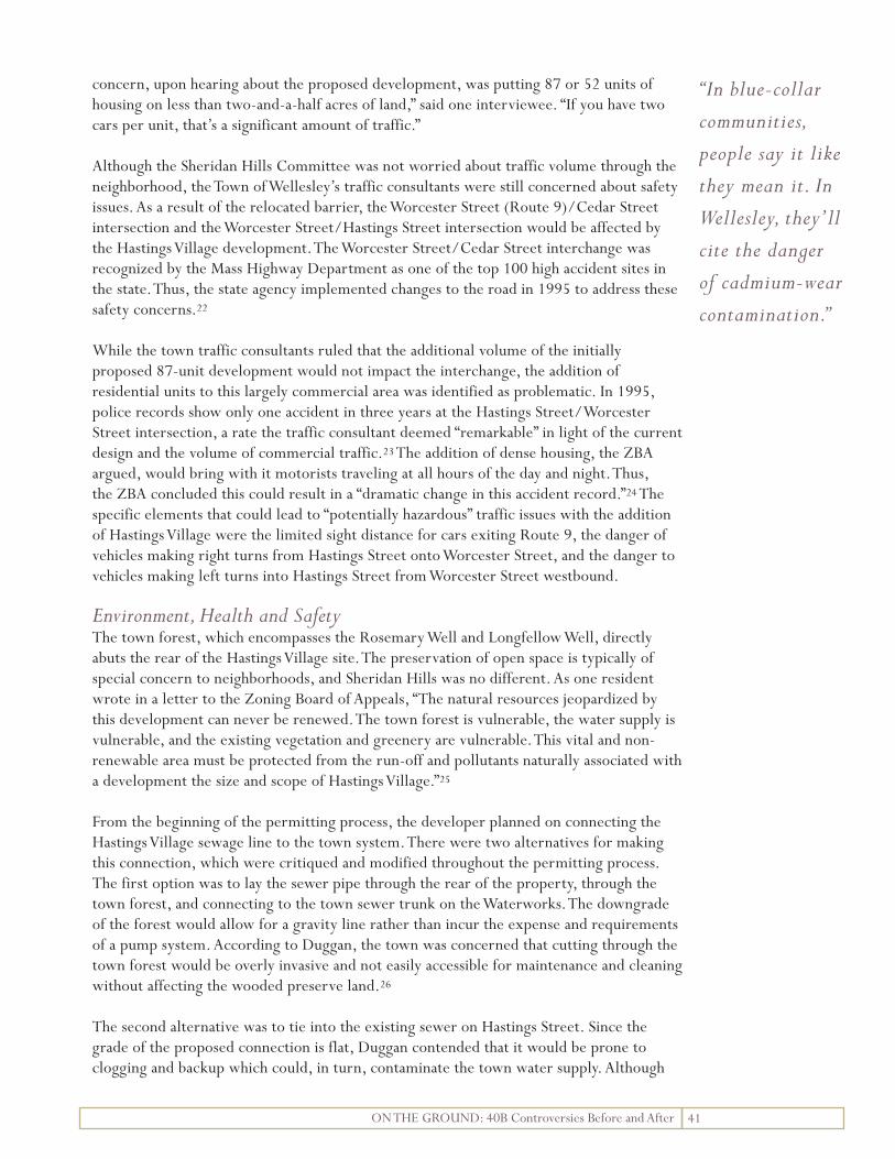
concern, upon hearing about the proposed development, was putting 87 or 52 units of housing on less than two-and-a-half acres of land,” said one interviewee. “If you have two cars per unit, that’s a significant amount of traffic.”
Although the Sheridan Hills Committee was not worried about traffic volume through the neighborhood, the Town of Wellesley’s traffic consultants were still concerned about safety issues. As a result of the relocated barrier, the Worcester Street (Route 9)/Cedar Street intersection and the Worcester Street/Hastings Street intersection would be affected by the Hastings Village development. The Worcester Street/Cedar Street interchange was recognized by the Mass Highway Department as one of the top 100 high accident sites in the state. Thus, the state agency implemented changes to the road in 1995 to address these safety concerns.22
While the town traffic consultants ruled that the additional volume of the initially proposed 87-unit development would not impact the interchange, the addition of residential units to this largely commercial area was identified as problematic. In 1995, police records show only one accident in three years at the Hastings Street/Worcester Street intersection, a rate the traffic consultant deemed “remarkable” in light of the current design and the volume of commercial traffic.23 The addition of dense housing, the ZBA argued, would bring with it motorists traveling at all hours of the day and night. Thus, the ZBA concluded this could result in a “dramatic change in this accident record.”24 The specific elements that could lead to “potentially hazardous” traffic issues with the addition of Hastings Village were the limited sight distance for cars exiting Route 9, the danger of vehicles making right turns from Hastings Street onto Worcester Street, and the danger to vehicles making left turns into Hastings Street from Worcester Street westbound.
Environment, Health and Safety The town forest, which encompasses the Rosemary Well and Longfellow Well, directly abuts the rear of the Hastings Village site. The preservation of open space is typically of special concern to neighborhoods, and Sheridan Hills was no different. As one resident wrote in a letter to the Zoning Board of Appeals, “The natural resources jeopardized by this development can never be renewed. The town forest is vulnerable, the water supply is vulnerable, and the existing vegetation and greenery are vulnerable. This vital and non-renewable area must be protected from the run-off and pollutants naturally associated with a development the size and scope of Hastings Village.”25
From the beginning of the permitting process, the developer planned on connecting the Hastings Village sewage line to the town system. There were two alternatives for making this connection, which were critiqued and modified throughout the permitting process. The first option was to lay the sewer pipe through the rear of the property, through the town forest, and connecting to the town sewer trunk on the Waterworks. The downgrade of the forest would allow for a gravity line rather than incur the expense and requirements of a pump system. According to Duggan, the town was concerned that cutting through the town forest would be overly invasive and not easily accessible for maintenance and cleaning without affecting the wooded preserve land.26
The second alternative was to tie into the existing sewer on Hastings Street. Since the grade of the proposed connection is flat, Duggan contended that it would be prone to clogging and backup which could, in turn, contaminate the town water supply. Although
41 ON THE GROUND: 40B Controversies Before and After
“In blue-collar communities, people say it like they mean it. In Wellesley, they’ll cite the danger of cadmium-wear contamination.”

neither alternative proposed by the developer for connecting to the town sewage main was entirely satisfactory to town government officials, the second alternative was deemed preferable by the Zoning Board of Appeals when the Supreme Judicial Court ruled that the project move ahead.
Storm water drainage was also a concern from the very beginning of the Hastings Village permitting process, in particular, the potential for contaminating the Rosemary Well. Many believed that, if proper measures were not taken to thoroughly assess the building’s footprint, the town’s water source would be vulnerable to contamination during both the construction of the development and once the buildings were constructed.
The drainage plan in the 2002 Comprehensive Permit placed the drainage system at the bottom of the basin, did not retain storm water, and outflow poured directly onto Waterworks land (i.e. the town water supply). Woodward & Curren, authors of the town’s site drainage assessment, expressed concerns about the site’s drainage plan, “Contaminants in parking lot runoff and any careless or accidental spills are sent directly to the aquifer with no possibility of detection or renovation.”27 Thus, with the addition of an impervious parking lot, impervious roofing, and the resulting concentrating of drainage, town officials were concerned that the outflow would be “dumped into one spot onto Waterworks land within proximity of the town wells.”28
Finally, the developer’s plan to use existing infrastructure for storm water runoff also concerned town officials. Duggan questioned the viability of this plan, stating that the existing storm drainage on Hastings Street did not have the appropriate capacity to handle any additional drainage.29 A consultant for the town recommended an 18-inch pipe for the Hastings Street storm drainage system, deeming the existing 10-inch pipe inadequate.30
Developer’s Track RecordThe Zoning Board of Appeals recognized in its 1995 rejection of the Hastings Village application that the developer’s track record is “not usually within the province of the Board of Appeals, as it is more properly the concern of the subsidizing agency.”31 But because there was no subsidizing agency to provide oversight, the developer’s track record and experience became a key controversy and concern of the opposition.
Brooks was wary of the intentions and track record of developer Logan Huffman from the start. “I ran into him one day at the site when I was out walking my dog. He told me he didn’t care if neighbors weren’t happy about the apartment buildings; he was building to earn his retirement money.”32 Several interviewees stated that Huffman’s track record was questionable: his most recent project, single family homes on Upwey Road in Wellesley, resulted in several lawsuits for shoddy construction and failing to comply with contractual obligations. It was also known that he left a subdivision in Ashland unfinished, opting to pay off the town rather than complete the project.
The Sheridan Hills Committee highlighted their concerns regarding the developer in a leaflet distributed to the neighborhood: “To our knowledge the developer has no previous experience building a project of this size or scale or managing an apartment complex. At the September 29th ZBA public hearing, testimony was presented regarding the developer’s prior construction projects and the problems which have been encountered as a result of the developer’s actions or inactions.”33
42 ON THE GROUND: 40B Controversies Before and After

Still, one interviewee felt the scrutiny of Logan Huffman was exaggerated. He was, after all, a fellow resident of Wellesley building on land that he rightfully owned. “There are things Logan Huffman was accused of doing that I think would even surprise Logan Huffman. To a degree, he got a rap he didn’t deserve. He wasn’t doing anything horrible or outside the law. He was just the villain.”
Property Values In Wellesley, the half-million dollar homes of the Sheridan Hills neighborhood are mostly occupied by “college professors, lawyers, engineers, teachers, and other highly educated people who tend to be Democratic,” said one interviewee. “We’re not the wealthy businessmen or conservative financiers. There aren’t many areas of Wellesley where you can easily point out two to four blocks of people who tend to vote Democrat, but this is one of them.”
Yet, even if residents of the neighborhood are progressive or proponents of affordable housing, people tend to look at their property investments in terms of resale. “A development may not bother someone who lives there now, but they may be thinking about whether it might be a concern to the next person who will live there,” said Rick Brown, retired town planner for Wellesley. “The neighborhood you live in is a big thing to
43 ON THE GROUND: 40B Controversies Before and After
Photo credit: Shannon Moriarty
“Although the road block separating Hastings Village from the Sheridan Hills community was a point of agreement between the developer and the neighbors, it seems to isolate the people in the development from the Sheridan Hills neighborhood, which is very unwelcoming.” -Former Town Planner Rick Brown

44 ON THE GROUND: 40B Controversies Before and After
people in suburban areas. When you buy a house in a wealthy community like Wellesley, you don’t want to be in the neighborhood with “it” in it. It’s human nature, not because they are bad people.”34
On the Ground: AfterThe Hastings Village Rental Community has been constructed and occupied since 2005. Eastland Partners, the original developer, remains the property owner and manager. According to Karen Fromm, the Hastings Village Property Manager, the controversies that consumed the Sheridan Hills neighborhood for over a decade seem to be unknown to the people living in Hastings Village apartments today.
Nevertheless, the addition of 52 units of housing to the Sheridan Hills neighborhood has certainly had impacts, large and small. Residents of the neighborhood have noticed slight changes in their neighborhood since the addition of the Hastings Village development. Brooks pointed out that the exterior lighting in Hastings Village allows him to “see his shadow in the middle of night.” Another interviewee agreed, “The building’s exterior lighting is extremely bright and shines in the wrong places at the wrong times.” Noise pollution has also become more noticeable to some neighbors: the removal of 2.2-acres
Photo credit: Shannon Moriarty

45 ON THE GROUND: 40B Controversies Before and After
of wooded area means there is less of a buffer between Route 9 and the Sheridan Hills neighborhood.
With the addition of people, one resident has noticed more unfamiliar faces walking around the neighborhood. “The intensity of people,” said Brooks, “has brought an intensity of dog droppings.”35 Yet, other neighbors who had taken part in the organization against the development have not noticed an impact at all. According to another interviewee, “For the most part, it’s out of sight and out of mind.”
Traffic Many of those interviewed for this study believe that the placement of the barrier at the north end of the development was key to mitigating traffic impact in the Sheridan Hills neighborhood. Although, Brooks points out that traffic has not gone completely unnoticed. “The barricade doesn’t show up on most GPS systems or in online maps, so you still get a lot of delivery vehicles, lost cars, and taxis dropping people off at the top of the hill.”36
Several Sheridan Hills neighbors believe that the dangers of the off-ramp have not been adequately addressed, “It is potentially really dangerous for residents of Hastings, cars come off Route 9 fairly quickly and it’s a blind turn.” Another interviewee added, “Traffic off Route 9 was already an issue with the car dealership and Harvard Community Health Care, but Hastings has added more cars to the area.”
City officials confirm that concern over traffic issues related to Hastings Village have not been realized to the extent feared. However, some of the steps taken to mitigate traffic concerns have had other, unrelated effects. “Although the road block separating Hastings Village from the Sheridan Hills community was a point of agreement between the developer and the neighbors,” said former town planner Rick Brown, “it [the road block] seems to isolate the people in the development from the Sheridan Hills neighborhood, which is very unwelcoming.”37
Environment, Health and SafetyDuring the development process, the sewer requirements were altered to allow for the installation of a gravity pump through the town forest. After so much scrutiny of the sewer lines and their environmental implications, this change seemed to happen without the Sheridan Hills Committee’s knowledge. “Interestingly, the developer did not connect to the Hastings Street sewer line as we thought, but to another sewer line through the town forest,” said one interviewee, “he saved a great deal of money because he was able to use a gravity line instead of a pump, thus circumventing the requirements of a pump.” But according to town officials, this connection to the town sewer main had no negative impacts on the town’s infrastructure or damaging environmental impacts whatsoever.
Retired Town Planner Rick Brown considered the Sheridan Hills Committee’s drainage concerns a red herring from the start. “If there was truly concern about pollutants in the town well, why wasn’t there concern about the automobile dealerships within 50 feet of the well, closer than Hastings Village? Or Route 9 and the potential for a hazardous waste truck overturning?”38
In the years before the Hastings Village development process began, several projects in Wellesley’s Water Supply Protection Districts were approved without dispute, such as
“The neighborhood you live in is a big thing to people in suburban areas. When you buy a house in a community like Wellesley, you don’t want to be in the neighborhood with “it” in it.”

46 ON THE GROUND: 40B Controversies Before and After
projects for Babson College, Silver Lake Dodge, and Wellesley Toyota. “The zoning by-law clearly gives the town the authority to have improvements completed if a risk actually exists,” wrote Huffman in a letter to the Wellesley Housing Partnership Committee. “Given the way all other projects are reviewed one can only conclude there is no risk until the project includes affordable housing.”39
Since the development of Hastings Village, city officials confirmed that there have been no issues with the storm water draining system. In addition, there has been no contamination to the Rosemary Well or the Rosemary Brook Water Supply Protection Area.
Summary of Controversies and Outcomes
Controversy Concern Outcome
Traffic The addition of residential units •will increase the volume of traffic coming off of Route 9, causing potential safety issues and increasing threat of accidents
No increase in accident inci-•dence
Environmental Impacts The building footprint would •impact runoff from the development into the town water supply, causing potential for contamination
No known impacts•
Infrastructure Impacts Existing sewer lines could not •accomodate the additional output from a dense development
No known impacts•
Developer’s Track Record The developer would not follow •through on project or create a shoddy development that might be an eyesore
Development looks nice and is •well-maintained
Property Values The addition of a dense •development of rental housing units would decrease the property values of abutting properties
Property values have not been •affected
Figure 13: Wellesley Controversy Summary
47 ON THE GROUND: 40B Controversies Before and After
Developer’s Track Record “I’ll be the first to tell you that in spite of my fears, it’s a nice-looking development,” said one interviewee, echoing the resounding sentiment among the Sheridan Hills residents interviewed. Nevertheless, some residents feel that the condition of the buildings, and the ability of the developer to effectively maintain them, can only be determined once more than four years has passed. “The buildings are fairly new, they aren’t really old enough to have required significant maintenance,” said Brooks. “We won’t know for another five to ten years how these buildings will hold up.”40
Property Values Anecdotal evidence confirms that properties in the Sheridan Hills neighborhood have not been impacted by the construction of Hastings Village. One homeowner who has lived in the neighborhood for over 20 years, confirms that, “this development has not had any effect on my property value.”
ConclusionCountless town officials, speculators, consultants, Sheridan Hills residents, and other individuals were involved in the decade-long battle to develop Hastings Village. Over a decade of hard work and debate went into the process to create a housing development that increased Wellesley’s affordable housing stock while meeting the preferences of the neighbors. Millions of dollars in private investment and public resources, not to mention thousands of volunteer hours and paid time, were dedicated to the process of developing Hastings Village. Although the outcome was not what all of the key players wanted, none of the people interviewed for this study expressed regret for their involvement in the process.
One resident feels that the project would not have turned out as it did if not for their scrutiny of and involvement in the project. “I like to think that the reason the development is 52 units instead of 87 is because of our neighborhood involvement,” one interviewee said. “If there was more I could have done to make it a 12- or 24-unit development, I most certainly would have done it.”
“I’ve learned that what we have there is not horrible, of course,” said one interviewee. “Clearly, one of the best ways you can bring affordable housing to a community is by building something a little more dense than what the zoning allows, and by incenting developers to do that.” One positive result of the Hastings Village process is that many of the community members who were involved have gone on to play key roles in town government posts, as housing advocates and as participants in the town’s planning process.
Still, an important question remains: has the focus on affordable housing effectively increased Wellesley’s stock of SHI units since the Hastings Village permitting process? No. Wellesley’s SHI currently accounts for 5.5 percent of all residential units in town, according to the DHCD SHI Inventory. No new affordable units have been created since Hastings Village was constructed in 2005, so the town is still vulnerable to 40B developments.
“I’ll be the first to tell you, it’s a nice-looking development.”

48 ON THE GROUND: 40B Controversies Before and After
Although Wellesley has not met the 10 percent SHI threshold, residents are no more receptive to 40B developments today than they were in 1994. In February of 2007, the chairman of the Wellesley Housing Development Corporation lobbied for the creation of five townhouse-style units, one of which would be affordable. The neighborhood’s reception to this plan can only be described as déjà vu. According to the Wellesley Townsman, “the proposal was met with skepticism and disapproval from neighbors and abutters, who said the proposed development was too dense, and that it would alter the character of Washington Street.”41
Endnotes1 U.S. Census Bureau, Census of Population and Housing, 2000: Summary Population and Housing Characteristics: Wellesley, Massachusetts. 2 U.S. Census Bureau, 2005-2007 American Community Survey 3-Year Estimates: Summary Population and Housing Characteristics: Wellesley, Massachusetts 3 Reed, “Affordable housing still an elusive goal” 4 Wellesley Housing Development Corporation, “Affordable Housing Policy for the Town of Wellesley,” adopted by the 1989 Town Meeting under Article 31 and amended by the 1997 Town Meeting under Article 42, http://www.ci.wellesley.ma.us/Pages/WellesleyMA_Selectmen/appoint/whdc (accessed April 3, 2009) 5 Huffman, “Eastland Partners to the Town of Wellesley Housing Partnership Committee” 6 Rick Brown, interview by author, March 23, 20097 Town of Wellesley Zoning Board of Appeals, “Amended Comprehensive Permit for Hastings Village, Inc. 54-66 Hastings Street” 8 Hinchliffe, “House Holiday Tour” (accessed April 2, 2009)9 Ibid10 Ibid11 Stanley Brooks, interview by the authors, March 26, 2009 12 Bob Engler, interview by the authors, April 3, 200913 Town of Wellesley Zoning Board of Appeals, “Amended Comprehensive Permit for Hastings Village,” 5114 Engler, interview by the authors15 Massachusetts Housing Appeals Committee, Wellesley Zoning Board of Appeals & others v. Housing Appeals Committee & others16 Huffman, Guest Column17 Engler, interview by the authors18 Brooks, interview by author 19 LaButti, “Sheridan Hills Resident to the Town of Wellesley Zoning Board of Appeals” 20 Engler, interview by the authors21 Ibid22 Town of Wellesley Zoning Board of Appeals, “Amended Comprehensive Permit for Hastings Village,” 4423 Ibid24 Ibid25 Strapp, “Sheridan Hills resident to Town of Wellesley Zoning Board of Appeals”26 Town of Wellesley Zoning Board of Appeals, “Amended Comprehensive Permit for Hastings Village,” 527 Town of Wellesley Zoning Board of Appeals, “Amended Comprehensive Permit for Hastings Village,” 39

49 ON THE GROUND: 40B Controversies Before and After
28 Ibid29 Town of Wellesley Zoning Board of Appeals, “Amended Comprehensive Permit for Hastings Village,” 4130 Ibid, 4031 Brooks, interview by the authors 32 Sheridan Hills Committee, Hastings Street Update33 Brown, interview by the authors34 Brooks, interview by the authors 35 Ibid36 Ibid37 Brown, interview by the authors38 Ibid39 Huffman, “Eastland Partners to the Town of Wellesley Housing Partnership Committee” 40 Brooks, interview by the authors41 Reed, “Affordable housing still an elusive goal”

50 ON THE GROUND: 40B Controversies Before and After

Chapter 7 Weston D ickson MeadowDickson Meadow, an 18-unit, mixed-income homeownership development, was one of Weston’s first 40B projects. Developed under the Local Initiative Program, and on land donated by residents for this purpose, the proposal received significant support and input from town officials and residents. Opposition to the project came exclusively from neighbors who wanted to lower the project’s density in order to mitigate a host of potential problems. Weston’s Board of Appeals approved The Community Builders’ comprehensive permit application, allowing the developer to build the total number of units sought, with few conditions attached. Though the density of the project was not lessened as opponents had hoped it would be, it seems that the potential negative impacts of Dickson Meadow that opponents feared have not been realized.
Weston Community ProfileWeston is a quaint and scenic suburb of Boston, located 12 miles west of the city. This largely residential community is one of the wealthiest in the state. Residents are proud of Weston’s reputable schools and beautiful homes in quiet and well-maintained neighborhoods. Another of Weston’s distinct features is its over 60 miles of hiking and horseback riding trails, golf courses, parks, ball fields, and other carefully preserved open space.1
Dickson Meadow Dickson Meadow was the third development in Weston to successfully include affordable housing units. The two mixed income developments built before Dickson Meadow were each unique. Built at a former school site, the Brook School Apartments, opened in 1979, features 75 apartments for people who are over age 62 or are handicapped. Of these 75 units, 55 are subsidized units funded through the HUD Section 8 program. The remaining units are supported by Weston’s Community Preservation Funds.2 Winter Gardens, a 50-unit
51 ON THE GROUND: 40B Controversies Before and After

homeownership condominium complex along Route 30, was completed in the 1990s, and was Weston’s first development completed under Chapter 40B.
Dickson Meadow differed from these earlier developments because it grew out of a family’s vision for their land; and because it encountered controversy despite the fact that its planning closely involved town officials and residents. In December 1997, Edward and Priscilla Dickson donated 10.8 acres of their property to a non-profit developer for the purposes of developing a mixed-income housing development on the site. The recipient was The Community Builders, Inc. (TCB), an experienced affordable housing developer in the Boston-area. TCB agreed to work with the Dicksons and their advisory board of town residents who had experience developing housing, to plan for Dickson Meadow. The site that the Dicksons selected had been undeveloped land in a neighborhood of single-family houses and more open space.3 The Dicksons and the Paine Estate, were the property’s only direct abutters. In fact, the closest structure to the site was 105 feet from the southern property border of this parcel, and was owned by the Dicksons.4 Other adjacent parcels were large, undeveloped tracts of wooded land owned by the Paine Estate. Parcels beyond these abutters contained single-family houses.5 The land in this area of town was zoned
for single-family houses each sited on 60,000 sq. ft. minimum sized lots. In other words, a maximum of .73 units were allowed per acre.6
On the Ground: BeforeAt the beginning of the planning process, the Dicksons and their Advisory Committee established key objectives of the mixed income development that they envisioned for this property: 1) to provide a minimum of six affordable homes in a mixed-income community; 2) to develop a total of 18 single family homes (12 were to be sold at market or moderate rates), in order to support six affordable homes and create a stable, balanced community; and, 3) to preserve as many trees and as much open space as possible, particularly with respect to the meadow that runs across the front of the development site, along Highland Street.7 In March 1998, Weston’s Housing Needs Committee approved a design concept for Dickson Meadow.
In May 1998, the Weston Board of Selectmen endorsed the development in connection with an application to the Local Initiative Program (LIP). Sometimes known as the “friendly 40B” process, LIP is “a state program that encourages the creation of affordable housing by providing technical assistance to communities and developers who are working together to create affordable rental opportunities for low- and moderate-income households.”8 According to TCB, the application was the product of their close
weston DemographicsPopulation 11,469
Area (square miles) 17.34
Race 90.3% White 6.8% Asian 1.2% Black
Median Household Income (1999 dollars)
$153,918
Total Housing Units 3,718
Owner Occupied 86.1%
Rental Occupied 13.9%
Median Home Value $739,200
Subsidized Housing Inventory (SHI)
SHI Before Development (1997)
2%(76 units)
SHI After Development (2008)
3.5%(133 units)
Figure 14: Weston DemographicsSources: 2000 Census Data, DHCD Community Profile, and DHCD Subsidized Housing Inventory
52 ON THE GROUND: 40B Controversies Before and After

collaboration with the Dicksons, their Advisory Committee, and the Board of Selectmen; and it reflected “their effort to plan a development that will meet the town’s need for affordable housing, within a self-sustaining project with a sensitive and suitable design that will fit the look and feel of the Town.”9 In addition, a written agreement between TCB, the Dicksons and the Board of Selectmen guaranteed the town the right to participate in development team meetings and to approve all significant aspects of the development.
TCB applied to Weston’s Board of Appeals for the comprehensive permit to build Dickson Meadow under Chapter 40B, after having received DHCD’s approval under LIP. According to TCB, the design for Dickson Meadows was consistent with standard health and safety practices, retained as much open space as possible, was attractively designed, and met the town’s affordable housing need.10 A broad range of community members agreed with this vision for Dickson Meadow, as letters submitted with the project’s LIP application indicate.11
Polly and Edward Dickson’s idea to donate their land for the creation of affordable housing came from the unlikeliest of sources: a Weston resident who was opposed to affordable housing development. According to Dixon, “At a town meeting, I heard someone ask ‘why don’t you spread the affordable housing throughout the town instead of having it all right where we are?’ I thought, ‘Well, that sounds like a good idea – we should build some here.’” They did not think a housing development would inconvenience anyone, since they didn’t have any neighbors in close proximity. “The development would be next to us, and the other end of it was vacant,” said Dixon. “We did not know where any potential opposition would come from. As it turns out, they [opponents] surfaced all up and down Highland Street.”12
As Dickson indicated, some neighbors strongly opposed the Dickson Meadow plan. In fact, documented opposition to the project came exclusively from neighbors to the development site. Shortly after TCB proposed Dickson Meadow, some neighbors organized the Highland Area Neighborhood Association, which lobbied town officials to purchase the land in order to control its development. In the neighbors’ own words, “We live in the Highland Street area and support the proposed creation of affordable housing units on Highland Street. However, we are concerned about the site plan, density, preservation of trees and open space, building architecture, and other similar matters. If done correctly, this development can be an asset to the neighborhood and to the town. But any land development, if done incorrectly, will be a permanent mistake….”13 As outlined above, those in opposition to Dickson Meadow raised concerns over density and the destruction of open space, mainly, but also to the site plan and architecture proposed for Dickson Meadow.
53 ON THE GROUND: 40B Controversies Before and After
Figure 15: Weston CIS MapMap credit: Massachusetts CIS 2009

54 ON THE GROUND: 40B Controversies Before and After
Density All of the concerns raised by opposing neighbors were centered around issues of density. Reducing the density, opponents claimed, could solve multiple problems that Dickson Meadow potentially posed. At public hearings to consider TCB’s comprehensive permit application and in correspondences from abutters to town officials,14 community members opposed to the plan encouraged the Board of Selectmen to reduce the number of units from 18 to a 12- or 13-unit development.15 Reducing the number of units, these community members argued, would address several problems, including their concerns over road safety, open space, and the layout of the development. In all written records throughout the process, neighbors supported the development of six affordable housing units at the site. TCB, in turn, defended the need for 18 total units and 12 market rate units for Dickson Meadow in order to maintain the project’s economic viability: fewer market rate units would yield an insufficient subsidy to support six affordable units.16
Neighbors encouraged town officials to encourage the town to buy the Dickson’s 10.8 acres so that Weston-- rather than TCB-- could oversee the development of a smaller mixed income development on the property.17 About ten Highland Street area neighbors organized themselves and their lawyers around this initiative. These neighbors argued Weston’s right to purchase the land that the Dicksons were offering to TCB under MGL Chapter 61A, which states that a city or town has the right to purchase a land parcel that is changed from agricultural to residential land-tax status—as the Dicksons had recently done with this parcel—within 120 days of that transfer. One neighbor, Richard Harrison, acted independently to create a new nonprofit, WCAH, Inc., to which he hoped the town would turn over development rights, so that WCAH could implement its plan for only a 12 unit development for the site. Harrison temporarily delayed Weston’s Board of Selectmen from rejecting the town’s option to buy the land via a temporary restraining order from Middlesex County Superior Court that suspended the Town’s authority to decide on the matter. Within a week, however, a Superior Court Judge denied an injunction that would have stalled the development process further.18 When Weston did not purchase the land, Harrison offered $1 million to TCB or any other developer who would adopt WCAH’s12-unit plan for Dickson Meadow.19
The town did not move to purchase the land, as some neighbors had hoped it would, because it recognized that TCB’s Dickson Meadow plan was the most immediate and least expensive way for Weston to gain mixed-income housing. “The town saw The Community Builders’ proposal for Dickson Meadow as being in its best interest,” said Nichols. “I think it’s fair to say that the Board of Selectmen felt that this was a good use of that land. We knew we needed affordable housing in town and this seemed like a sort of wonderful way to get it, because the land was being donated.”20
Open SpaceRelating to the density concern, neighbors claimed that Dickson Meadow would destroy beloved open space. A plan that pared down the number of units for the development would leave more open space at the site, opponents argued. As Kenneth Fish, a member of the Dickson’s Advisory Committee, described the land before it was developed, “It was a beautiful meadow, surrounded by trees. It was used for growing hay but was otherwise undeveloped.” Complaints about development arose because, “the neighbors were going to miss it.”21 Larry Gerber, another Weston resident and former head of the town’s Housing Needs Committee explained, “Highland and the surrounding streets are among the most
“The development would be next to us, and the other end of it was vacant. We did not know where any potential opposition would come from. As it turns out, they [opponents] surfaced all up and down Highland Street.”

55 ON THE GROUND: 40B Controversies Before and After
desirable in Weston, because of the scenic open space there. Though most of this space was owned by the Dicksons the neighbors wanted to preserve that open space.”22 Many in town, Gerber observed, believed that at least one of the neighbors who had led the opposition to Dickson Meadows had built a huge mansion next to that empty piece of the Dicksons’ property, feeling that this abutting land should remain undeveloped. The problem was, of course that, “no one guaranteed land near his property would never be developed. It wasn’t conservation land; it was owned by the Dicksons.”23
Site Plan, Architecture, and Impact on Surrounding PropertiesOpponents were concerned that the turning radius and grade of Dickson Meadow’s road, as originally proposed by TCB, would be unsafe. TCB’s engineer defended the safety of the planned road, while opponents argued that reducing Dickson Meadow’s density would allow for a safer design for the development’s looping road, Livermore Lane.
Concerns about the septic system that TCB originally proposed for Dickson Meadow were cited by the Town Board of Health and neighbors who worried the system’s capacity would be inadequate and that it was too close to the development’s property line.24 Opposing neighbors hired an engineer to test soil percolation at the development site. Their engineer expressed concern that Dickson Meadow could encounter storm water drainage problems, where TCB’s engineer did not identify this as a problem after repeated tests.25
Neighbors were also concerned about the quality of the buildings and landscaping at Dickson Meadow. Besty Nichols, a former Weston Selectman who served as the Board of
Photo credit: Google Earth
All of the concerns raised by opposing neighbors were centered around the issue of density.

56 ON THE GROUND: 40B Controversies Before and After
Selectmen’s advisor to the Dickson Meadow development team, explained that some town residents feared for their property values because they perceived that affordable units might make Dickson Meadow prone to poor quality or unattractive construction. “The fact that it was a mixed income development led to concerns about maintenance and how it would affect property values. Property values are a big deal in this town since people put so much money into their homes.”26
In its final decision to approve The Community Builders’ comprehensive permit application, the Weston Board of Appeals summed up the arguments for and against the Dickson Meadow proposal.27 While reducing the number of homes at Dickson Meadow, “might be financially feasible and would have a less disruptive impact on the area and mitigate health and safety and environmental concerns strongly expressed by opponents,” the Board contended, it also acknowledge that it was “faced with impressive legal constraints against its [the Board’s] right to redesign or substantially modify the proposed project in view of many countervailing considerations.”28 These constraints included: providing the developers a “margin for risk,” maintaining costs high enough to build well-constructed and landscaped homes, maintaining enough units to proportionally distribute condo fees across all units, and wanting to encourage the creation of moderate-rate homes within the development.29 The Board thereby granted a comprehensive permit for Dickson Meadow to The Community Builders based on terms and conditions set forth in the developers’ application and subsequent supplementary documentation.30 The decision included twelve conditions set forth by the Board, but these did not appear to require substantial changes to the plan outlined in The Community Builders’ application.31
On the Ground: AfterNeighbors’ main concerns about Dickson Meadow during its proposal stages focused on density and open space, TCB’s site plan and the architecture of its proposed buildings. The
Photo credit: Alexandra DeGenova

57 ON THE GROUND: 40B Controversies Before and After
negative impacts that neighbors feared would result were not realized at Dickson Meadow, aside from the reality that the development did create a denser collection of homes than what previously existed in the neighborhood and on the previously empty site. This however, did not harm the community, as Weston residents have recognized.
Many of the key players involved in Dickson Meadow’s development, including town government officials, development advisors, and Dickson Meadow residents, agree that since Dickson Meadow opened, the dissent that some neighbors expressed during the planning stages has disappeared. “It’s been accepted, I would say, as an existing part of the town,” said Dickson, who still lives adjacent to Dickson Meadow.32 Gerber agreed, “Anyone I’ve ever run into in town has liked living at Dickson Meadow. There was no subsequent controversy that I know of.”33 Sally Locke who, with her husband, bought the first home at Dickson Meadow said, “My husband and I followed it in the newspapers during the building stages when it was very controversial. Now that it is built and blended into surroundings and environment, I don’t sense any hostility.”34 According to Donna VanderClock, the Weston Town Manager, the only complaints the Town hears regarding Dickson Meadow are residents calling to question disproportionate condo fees and income eligibility standards for affordable residents. “Nobody has called about concerns that were raised about the development before it was constructed.”35
DensityThe Comprehensive Permit allowed TCB to create the 18-unit development that it sought in its permit proposal. With this permit, Weston’s Board of Appeals allowed the developer to increase density normally permitted for this area of town to 1.8 units per acre, with lot sizes measuring 37,800 sq. ft.36 Fourteen of the homes were built as detached structures.
Photo credit: Alexandra DeGenova
Livermore Lane today. Curve that some considered “dangerous” in original site plan has not caused known problems.

58 ON THE GROUND: 40B Controversies Before and After
The remaining homes were built as two-family structures attached by garage to minimize overall density.37
Open SpaceTo meet the objective of preserving open space, Dickson Meadow’s homes were built in a ring around 2.5 acres of the existing meadow. That encircled land has been permanently preserved as open space thanks to a town conservation covenant.38 TCB addressed some of opponents’ open space concerns in the final Dickson Meadow site plan, which left 82.5 percent of the land tract (8.25 acres) undeveloped. Buildings now account for just 7.5 percent (0.75 acres) of Dickson Meadow; while parking and pavement cover the remaining 10 percent (approximately one acre) of the site.39
Site Plan, Architecture, and Impact on Surrounding PropertiesAccording to Alan Slawsby of Slawsby and Associates, the management company that maintains Dickson Meadow, “There really have been few operational challenges. There were some minor punch list items for homes which the developer, by and large, completed.”40
Summary of Controversies and Outcomes
Controversy Concern Outcome
Density Too many units for land area• 18 units built on 10.8 acres, as •proposedNo direct negative impacts •found
Open Space Development would destroy •open space that should be preserved
Homes replaced some open •space2.5 acres of development site •preserved as conservation land
Site Plan, Architecture, and Impact on Surrounding Land
Unsafe road design•Inadequate septic and drainage •systemsRisk of poor quality or •unattractive construction and landscaping Development would not fit into •the neighborhood Problems with development or •unappealing aesthetics could lessen surrounding property values
No reported problems with •road design, septic and drainage systems, building construction or landscapingTown residents report the •development fitting into its surroundingsNo known impact on •surrounding property values
Figure 16: Weston Controversy Summary
59 ON THE GROUND: 40B Controversies Before and After
In its decision to approve a comprehensive permit for Dickson Meadow, the Weston Board of Appeals acknowledged that, “the private roadway, while curved and undulating has been modified to a degree that should be less hazardous than many in town.”41 In an updated plan submitted before the Board came to its decision, TCB amended the road grade. The Board upheld this version of the roadway plan in its permit approval decision. These changes alleviated the problem and there has been no evidence of continued concerns.
When asked about any reported building problems at Dickson Meadow since residents have moved in, VanderClock, replied, “I think everything’s okay there physically. We had a quality developer, so there have been no structural problems. The infrastructure was solid. We have had problems with the septic system in another development; but not at Dickson Meadow.”42 Of the septic system, Locke noted, “occasionally we have troubles with the septic pump, but other than that, Dickson works pretty smoothly.”43 Adequate capacity and the positioning of the septic field too close to adjacent properties- rather than the functioning of the pump- were opponents’ worries for the septic system at Dickson. Thus, it can be said that pre-development concerns about the septic system at the development were not realized once it was built. There is also no evidence of drainage problems as the development site. Any problems or concerns over these two systems may have been alleviated through conditions that the Appeals Board placed on the permit and that TCB implemented to ensure that the systems meet all local and state government health and safety requirements.44
Where some neighbors had raised concerns over the aesthetics of the development and the quality of what would be built there during the development process, Locke sees no cause for such concerns these days. “It’s a very well thought out community. The houses are very well constructed and the landscaping was intended to be well done. As money became tighter at the end of construction, the landscaping became a bit more sparse, but it still looks nice.”45 To help Dickson Meadow fit into its surrounding neighborhood, the site and landscaping plans for the site called for the preservation of as many trees and stonewalls as possible.46 “Since it’s been built, many people, including some who opposed it, have told me, ‘Oh, but it looks so nice,’” said Dickson.47 Alluding to some Weston residents’ misconceptions of what a mixed-income development would look like, Nichols added, “When you hear ‘mixed income’ facility, you don’t necessarily think it’s going to look as nice as Dixon Meadow.”48 Many who were involved in the planning of Dickson Meadow underscored the choice of a reputable architect for the Dickson Meadow homes, when interviewed. “We went with Acorn as the architects. Part of why we chose them was because they were well known for setting the houses in conformity with the terrain. We were very impressed with their architect. And if you drive by you think, ‘That looks alright.’ I would say physically it has not been a problem,” explained Dickson.49
Supporters of the original Dickson Meadow proposal suggested that opposing neighbors had underlying fears that it would reduce their property values. The Board of Appeals’ decision also acknowledges the existence of these fears in referencing the potential “negative impact on surrounding properties.” Though it is impossible to know how the value of properties neighboring Dickson Meadow may have risen or fallen if the development had not been built, a general upward trend in property assessment values for homes closest to Dickson from the year that Dickson opened until recently mirrors the increased trend in property values throughout Weston during the 2000s.50 This may indicate that the construction of
The increase of affordable units in the community has increased town residents’ awareness of the need for more affordable units and the need for Weston to contribute.

60 ON THE GROUND: 40B Controversies Before and After
Dickson Meadow did not devalue property in the surrounding neighborhood.51 Dickson and Nichols both echoed this finding, attesting that there hasn’t been any reduction in property values in the neighborhood since the development was completed.52
ConclusionThe most evident effect that Dickson Meadow has had on Weston is that it increased the town’s affordable housing stock by six units, its moderate-rate units by two, and its market-rate condominiums by six. But those closest to the development insist that it has had other effects on the Weston community. Dickson said she has seen a direct connection between Dickson Meadow and the housing constructed in Weston under Chapter 40B since. “I think the main impact was that affordable housing became a household term in Weston, which it had not been before,” she said. “This is partly because of what we were doing and partly because of what was going on in the wider, greater Boston community.”53 For Locke, Dickson Meadow has made Weston residents, “a little more aware that there are people who need homes at a reduced price.” And the increase in affordable units in the community, has increased town residents’ awareness of the need for more affordable units and the need for Weston to contribute, she believes.54 Also important, Locke stressed, is the role Dickson Meadow played in the way that Weston residents perceive affordable and moderate rate housing. “People realize that we all keep our homes looking nice and that we are good neighbors,” Locke said of neighbors’ opinion of Dickson Meadow’s residents.55
Several interviewees highlighted the increase in moderate-income housing that Dickson Meadow provided the town as an important outcome of this development on the community. “People couldn’t buy into Weston for what single homes cost at market value. In these types of developments, we were providing housing that served a need, separate from the affordable housing component,”56 explained Gerber.
While not necessarily a direct result of the construction of Dickson Meadow, a much larger, mixed-income development located next to Dickson Meadow is currently in the final stages of development. Highland Meadow will feature 70- homeownership development including seven affordable units. Some Weston residents that we spoke to alluded to the possibility that, because Dickson Meadow fit into the community so well, it may have made it easier for new affordable and mixed-income developments, such as this one, to succeed in Weston. Highland Meadow and other affordable housing proposals, in addition to the creation of the Weston Affordable Housing Partnership, indicate that the Town of Weston is proactively planning to increase its stock of affordable housing. This may be a result of lessons learned from Dickson Meadow.
Endnotes1 Town of Weston, “About Weston” (accessed April 24, 2009)2 Town of Weston, Housing Department, “Brook School Apartments” (accessed April 10, 2009)3 The Community Builders, Inc. to Massachusetts Department of Housing and Community Development, Application for Local Initiative Program Dickson Meadow Affordable Housing. Town of Weston4 The Community Builders, Inc. Application for Local Initiative Program
61 ON THE GROUND: 40B Controversies Before and After
5 Ibid6 Ibid7 Ibid8 Massachusetts Department of Housing and Community Development, “Local Initiative Program (LIP)” 9 The Community Builders, Inc. Application for Local Initiative Program10 Ibid11 Ibid12 Polly Dickson, interview by the authors, March 26, 2009 13 Highland Area Neighborhood Association to The Board of Selectmen and the Town of Weston, “Open Letter” 14 Weston Board of Appeals public meetings on January 14, 1999; February 4, 1999; and February 24, 1999.15 Highland Area Neighborhood Association to The Board of Selectmen, “Open Letter” 16 The Community Builders, Inc. to Zoning Board of Appeals, Town of Weston. Supplementary Information to Comprehensive Permit Application. Dickson Meadow. Town of Weston, 7 17 Regan, “Judge Lifts Order” 18 Ibid19 Regan, “Dickson Decision Next Week” 20 Betsy Nichols, interview by the authors, March 26, 200921 Ken Fish, interview by the authors, March 17, 200922 Larry Gerber, interview by the authors, March 27, 200923 Ibid24 The Community Builders, Inc. to Zoning Board of Appeals, Town of Weston, “Design Issues Memorandum”25 The Community Builders, Inc. to Zoning Board of Appeals, Town of Weston, Supplementary Information to the Comprehensive Permit Application26 Nichols, interview by the authors27 Town of Weston Board of Appeals, “Dickson Meadow Comprehensive Permit Decision”28 Ibid29 Ibid30 Ibid31 Goodison, “Controversial Weston Affordable Housing Plan Is Approved” 32 Dickson, interview by the authors33 Gerber, interview by the authors34 Sally Locke, interview by the authors, March 26, 200935 Donna VanderClock, interview by the authors, March 27, 200936 The Community Builders, Inc. Application for Local Initiative Program37 Ibid38 Ibid39 Ibid40 Alan Slawsby, questionnaire prepared by the authors, email and fax correspondence, March 31, 200941 Town of Weston Board of Appeals, “Dickson Meadow Comprehensive Permit Decision” 42 VanderClock, interview by the authors43 Locke, interview by the authors44 Town of Weston Board of Appeals, “Dickson Meadow Comprehensive Permit Decision” 45 Locke, interview by the authors

62 ON THE GROUND: 40B Controversies Before and After
46 The Community Builders. Inc. Application for Local Initiative Program47 Dickson, interview by the authors48 Nichols, interview by the authors49 Dickson, interview by the authors50 Town of Weston Assessors’ Office staff, conversation with the author, April 200951 Town of Weston, Assessors’ Office, Assessment Records for Properties on the Comprehensive Permit Application for Dickson Meadow’s List of Certified Abutters, Assessors’ database52 Nichols, interview by the authors53 Dickson, interview by the authors54 Locke, interview by the authors55 Ibid56 Gerber, interview by the authors

Chapter 8 Conclus ionEach 40B project is unique. There are differences in tenure, scale, residential composition, socio-economic demographics and, of course, differences in the communities in which they are located. Many 40B projects are proposed and developed without controversy, while others are met with opposition and fear. In this report, we have studied four different projects that demonstrated clear opposition and controversy. The concerns that were raised varied for each project, but the roots of the controversy involved fears about the loss of local control over zoning and unknown impacts of the proposed development. Of course, the heart of the Comprehensive Permit Law involves the ability of the state to override local zoning. In fact, proponents argue that this is the very reason why the law has been successful in creating more than 26,000 units of affordable housing during its 40 years.
Despite the law’s success, controversies around 40B continue to arise. Municipal governments want to be able to plan for and manage their own growth. Among their tools is the ability to enact and enforce local zoning laws. Private citizens choose a place to live based on their perceptions of neighborhood character, aesthetics, home values, accessibility, quality of schools, safety and a number of other qualities. They expect that their neighborhood will retain these qualities and that they will be protected from unwanted uses, based on existing zoning. When a state is in a position to remove control over land use decisions from the locality, there is sometimes controversy and organized opposition. This significant power of the state may stimulate an overstatement of the concerns and fears by the opposition. At the same time, proponents point out that municipalities have had 40 years, since the enactment of 40B, to increase their stock of affordable housing on their own terms.
63 ON THE GROUND: 40B Controversies Before and After

For this study, four sites were selected using a mixed methodology, where a number of filters were applied to a set of developments monitored by the Client and another set of developments compiled by the researchers from other sources. Through interviews with key stakeholders and archival research, this study has found that the fears and concerns expressed during the permitting process of four highly controversial 40B developments have not been realized. This was true of both of the two sites selected from the Client list (Walpole and Weston) and those selected from other sources (Newton and Wellesley).Nearly all of the controversy has evaporated now that the developments have been completed and occupied. A partial explanation for this result may be that the heightened fears and opposition during the permitting process led to negotiations and concessions between the municipalities and the developers that resulted in improved developments. For example, the Wellesley ZBA required improvements and mitigation to potential environmental, drainage and traffic impacts. Also, the Newton ZBA granted a comprehensive permit with conditions to monitor the engineering, landscaping and contracting decisions of the developer. In the Walpole case, many of the fears raised by the town such as impacts on school enrollments, and sewer and water capacity issues involved services that every municipality is legally obligated to provide. But here too, the concerns about undue costs were overstated and only minimally realized.
Moreover, there is evidence that the experience of the 40B process has yielded some other benefits to the municipalities in addition to the increase in affordable housing. In three of the four locales studied in this report there is significant evidence that, as a result of the controversial 40B developments, the communities are more aware of the need for affordable housing and are being more proactive in planning for and developing that housing. In the last ten years, the City of Newton’s Subsidized Housing Inventory has risen from 4.9 to 7.6 percent, and the Town of Walpole’s has increased from just below 2 to 5.7 percent. Walpole has also created a Housing Production Plan and it has been approved and certified by the DHCD through 2013. In Weston, the Town has established an Affordable Housing Partnership to involve town officials from several departments in increasing Weston’s affordable housing units. The more proactive stances in these three communities may lead both to more affordable housing units, as well as to the more managed growth and the local control that the cities and towns desire. This may result in better working relationships with developers, city and town government officials, and with community residents and groups, to bring more positive outcomes and less controversy to the affordable housing production process. As communities gain experience with developing 40B housing, hopefully the level of controversy will diminish. This study provides significant evidence that the fears of new affordable housing development are far more myth than reality.
64 ON THE GROUND: 40B Controversies Before and After
This study provides significant evidence that the fears of new affordable housing development are far more myth than reality.

65 ON THE GROUND: 40B Controversies Before and After

66 ON THE GROUND: 40B Controversies Before and After

67 ON THE GROUND: 40B Controversies Before and After
Appendix AHousing Appeals Committee Review
Figure 17: HAC Process
Comprehensive Permitting Process
The Housing Appeals Committee is a body consisting of five members who hear and rule on disputes involving Chapter 40B, the Massachusetts Comprehensive Permit Law. Its mission is “to provide, within the parameters of the comprehensive permit process [. . .], an impartial forum to resolve conflicts arising from the siting of affordable housing.” This mission is carried out while attempting to balance the need for affordable housing and “legitimate local concerns – planning, environmental, open space, design, health, safety, and other local concerns.”1 Per the Comprehensive Permit Law, a local zoning board of appeals (ZBA) can grant a comprehensive permit that overrides existing town zoning and other local regulations. If the ZBA denies the comprehensive permit or imposes conditions that “make the proposal uneconomic,” a qualified developer can appeal the decision to the Housing Appeals Committee. A qualified developer is “any developer of housing approved under an eligible state or federal housing program who has been denied a comprehensive permit by a Zoning Board of Appeals in a city or town with less than10% of its housing units affordable to low or moderate income persons.”2 Once a city or town meets the 10% threshold (as measured through the Subsidized Housing Inventory, a listing maintained by the Massachusetts DHCD), the municipality is said to “have met ‘local needs’ for affordable housing and has the right to deny applications by developers to obtain Chapter 40B comprehensive permits.”3
See Figure 17 for a graphic representation of possible paths comprehensive permit applications can take.

68 ON THE GROUND: 40B Controversies Before and After
69 ON THE GROUND: 40B Controversies Before and After
Much research has been done to evaluate and to criticize Chapter 40B as a mechanism for expanding the availability of affordable housing and to assess it impact on specific issues or controversies (including property values and municipal services). In his mostly favorable assessment, Paul Stockman asserts that with its 10% threshold for HAC override immunity, Chapter 40B “implicitly sacrifices a full attainment of the regional housing need [. . .] but it serves as an effective vehicle for achieving reasonable and stable levels of suburban heterogeneity.”4 Stockman maintains that the Massachusetts zoning appeals system takes local concerns into account, almost to a fault; and that localities have many opportunities “to ensure that legitimate planning considerations are addressed and resolved.”5
Stockman also suggests a number of possible revisions to MGL Chapter 40B. These include: (1) guarding against the construction of elderly housing at the expense of family housing; (2) needing to safeguard the zoning appeals system from procedural delays; (3) constraining localities’ ability to create delays; (4) integrating future state environmental laws into the process, and (5) strongly discouraging appeals to the courts from HAC decisions.6 Subsequent studies addressed many of these concerns.
On the occasion of its thirtieth anniversary, Sharon Krefetz presented a much more critical assessment of the Comprehensive Permit Law. In Krefetz’s estimation, “Chapter 40B has not produced anywhere near the amount of affordable housing that is needed, nor has it overcome all the obstacles to ‘opening up the suburbs.’ It has created small toeholds, but the walls of suburban exclusion remain high.”7 The author divided the history of Chapter 40B into four distinct periods: an initial period of turbulence (1970-1979), a period of relative calm (1980-1984), years of increased activity (1985-1989) spurred by the passage of Executive Order 215,8 and an era of local reassertion of influence (1990-1999).9 In so doing, Krefetz highlights key changes to local responses, state actions, and the types of projects that tend to be built. Included among these changes are: (1) the shift from elderly housing to multifamily housing, due to changing demographics and the framing of a housing crisis in terms of a lack of family housing in the 1980s;10 (2) the decrease in ZBA denials of comprehensive permit applications and the decrease in HAC decisions overruling the ZBA because of increasing collaboration and accommodation between developers and ZBAs; and (3) a decrease in the size of projects proposed and built, as a result of the increased active involvement of city officials in proposals for affordable housing in their municipalities.11
Krefetz concludes that “state and federal actions and funding programs need to be expanded, including more direct subsidies for the construction of low-income housing and offsetting funds for services.”12 As long as few low-income people live in certain localities and are unable to exert political pressure on local governments to create affordable housing, and as long as local property taxes subsidize the creation of housing, infrastructure and services, the need for low- and moderate-income housing will not be fully met.13 The best laid plan for the construction of affordable housing are only as effective as financial and
Appendix BLiterature Review

70 ON THE GROUND: 40B Controversies Before and After
economic realities allow. Pockets of opposition will persist; and where political will and economic feasibility allow, affordable housing projects will continue to be approved.
In their “Mixed Income Housing in the Suburbs: Lessons from Massachusetts,” Gornstein and Verrilli hail a number of regulatory changes made to Chapter 40B for giving communities tools and reasons to proactively plan for and encourage new affordable housing development. These changes include the 1998 HAC ruling that qualified the Federal Home Loan Bank of Boston’s New England Fund (NEF) program as 40B-eligible funding.14 DHCD also responded with new regulations in 2001 and 2002 that gave increased power to municipalities in the face of increasing numbers of 40B applications by:
Eliminating the right of developers to appeal decisions on very large projects; •Providing time-limited exemptions from ZBA decision appeals for towns that have •increased housing by a significant amount in the last 12 months; and Creating a monitoring process for projects using NEF and other non-governmental •funding that imposed income limits and allowed local preference for 70% of occupants.15
However, the authors maintain that these changes “do not remove the biases of fiscal zoning.”16 In approaching development with a myopic view toward “the net fiscal impacts of development today, [communities tend] to encourage mixed income non-family housing - especially elderly and age-restricted (55+) developments.”17 In practice, Massachusetts municipalities have constrained the extent to which mixed-income development reduced concentrations of poverty with higher income targeting, increased use of local preferences and the exclusion of families.18
In 2003, Governor Mitt Romney appointed a Chapter 40B Task Force to address the opposing factions of affordable housing advocates who support Chapter 40B and opponents who argue that it impedes a municipality’s ability to control its own growth.19 The task force made a number of recommendations, including:
Counting affordable units in homeownership developments twice when calculating the •subsidized housing inventory in order to remove inequity in counting while preserving the incentive to create rental housing;Studying further the prospect of counting manufactured housing (mobile homes) in the •SHI, though the authors do not endorse adopting this approach;Allowing the municipality to submit written complaints to the subsidizing agency to be •answered by the applicant; andRequiring the Department of Housing and Community Development to update the SHI •at the request of the city or town (this was eventually enacted).20
Regnante and Haverty maintain that if the recommendations were adopted, they could “give municipalities a greater ability to plan for the creation of affordable housing [while giving developers] a better idea where and when an affordable housing development would be appropriate.”21
Fears of decreases in property values are of particular concern to abutters in Chapter 40B developments. A study conducted by MIT researchers concluded that, “large-scale, high-density 40B multi-family rental developments in single family neighborhoods [do] not affect the value of adjacent homes.”22 In addressing the effects of affordable housing on market values of nearby homes, George C. Galster posits that the impacts “depend in an interactive

71 ON THE GROUND: 40B Controversies Before and After
way on concentration, context, and type of development.”23 Concentration matters least when affordable housing is “inserted into high-value, low-poverty, stable neighborhoods,” and the construction and rehabilitation of affordable units can have positive impacts, just as long as an area does not succumb to too much concentration and “a diminishing marginal positive impact” as can be the case with large rental complexes.24 Neighborhoods with “modest values, nontrivial poverty rates, and owner perceptions of vulnerability” tend to experience smaller positive impacts and run the risk of experiencing negative impacts.25 Additionally, while owner occupied affordable developments provide more positive impacts than rental units, developments which “remove (through rehabilitation or construction) a preexisting source of negative externalities likely generate more positive impacts than those developed on vacant land.”26
Nakosteen and Palma claim that population growth associated with new housing does not necessarily yield increases in demand for services or higher municipal costs.27 The fact that municipal costs tend to increase regardless of growth suggests “that the standard models relied upon by cities and towns to estimate the fiscal impacts of development may be systematically overestimating these costs in many communities.28 The authors suggest that their results might even show that growth saves money “by slowing down per capita increases in costs.”29 However, they also suggest that “growth squeezes municipal budgets and makes certain mandated expenditure areas, such as education, take precedence over others, such as public works.”30 Nakosteen and Palma suggest an alternative approach (the marginal-cost method) to forecast the fiscal impacts of housing developments.31
In a 2007 study, Nakajima et al. employ the marginal cost method, the per capita multiplier method and an original methodology (the fair share method) to understand the fiscal impacts of mixed-income affordable housing. The fair share method compares the distribution of residential property taxes to the average cost of municipal services per housing unit. Through the study of eight home ownership housing developments, the authors found that none had measurably negative impacts on public services in their respective municipalities. Also, Nakajima et al. suggest that since school costs are rising even in places with declining enrollments, other factors are at play in boosting these costs. Finally, through the use of the fair share methodology, the authors find that mixed-income units (including 40B projects) have fiscal impacts the same as surrounding properties.32
The authors of On the Ground hope to add it to the canon of works on Chapter 40B, its impacts and its effects. This report is positioned well to respond to some of the questions Krefetz posed on the occasion of the Comprehensive Permit Law’s 30th anniversary: what are the effects that 40B projects have had on communities in which they have been built; how have the attitudes of community residents changed, especially those who were initially opposed; and have property values, local school or town budgets been greatly impacted?33 It is these issues, and other initial community concerns and current perceptions of 40B projects that On the Ground addresses.

72 ON THE GROUND: 40B Controversies Before and After

73 ON THE GROUND: 40B Controversies Before and After
Appendix CFurther Research
This study, raised several questions and topics for topics for further research. These include:
Do controversial 40B projects tend to have more conditions placed on their permits and •more negotiations between ZBAs and developers than do non-controversial projects? And if so, what is the nature of the conditions and negotiations?
How do projects constructed under the Local Initiative Program (LIP) compare to •other 40B developments? Are there still cases of abutter opposition, and if so, how do municipalities balance the concerns of their residents while collaborating with DHCD and the developer?
This study has concluded that three of the four cases appear to recognize the need for •affordable housing in their communities and have become more proactive in planning for that housing. A potential topic of research could be a study of the communities that currently have Housing Production Plans (HPP) certified by the DHCD. What is the history of 40B development in these communities? Have they always been more proactive in creating affordable housing? Or has the experience of highly controversial 40B developments spurred the community into developing an HPP?
How does the SHI 10% threshold (and subsequent immunity to zoning overrides) •motivate the development of affordable housing? As towns approach the SHI threshold, are they more likely to approve comprehensive permit applications in the hopes of attaining that goal? Or are many of the common controversies still evident in the proposals brought before the ZBAs?
A comparative study of market rate and affordable units within the same 40B •development. What sort of community dynamics result from stark disparities in condominium fees, home purchase values or monthly rent or wide ranges in income levels within these developments?

74 ON THE GROUND: 40B Controversies Before and After

75 ON THE GROUND: 40B Controversies Before and After
Appendix DList of Interviewees
The case studies detailed in this report relied heavily on information provided by key players in each development. Below is a list of individuals interviewed for each case study. A number of subjects chose not to be identified in this report and, therefore, are not listed.
Walpole – The PreserveMichael BoyntonDonald JohnsonJon RockwoodMichael Stanton
Newton – The Kayla’s House DevelopmentEileen Freiberg-DaleTrisha KenyonMichael KruseJosephine McNeilJason RosenbergAmy Yuhasz
Wellesley – Hastings VillageStanley BrooksRick BrownRobert EnglerKaren FrommMeghan Jop
Weston – Dickson MeadowPolly DicksonKenneth FishLarry GerberEdward LashmanSally LockeBetsy NicholsAlan SlawsbyDonna VanderClock

76 ON THE GROUND: 40B Controversies Before and After
Endnotes 1 Massachusetts Department of Housing and Community Development (DHCD), “Housing Appeals Committee.”2 Massachusetts DHCD, “Housing Appeals Committee,” DHCD Fact Sheets.3 Fisher, “Chapter 40B Permitting and Litigation.”4 Stockman, “Anti-Snob Zoning in Massachusetts: Assessing One Attempt at Opening the Suburbs to Affordable Housing.” Stockman refers to Massachusetts General Law, Chapter 40B, Sections 20-23 as the “Low and Moderate Income Housing Act of 1969.”5 Ibid, 569.6 Ibid, 577-9.7 Krefetz, “The Impact and Evolution of the Massachusetts Comprehensive Permit and Zoning Appeals Act: Thirty Years of Experience with a State Legislative Effort to Overcome Exclusionary Zoning,” 415.8 Massachusetts DHCD, “Affirmative Fair Housing Policy” (accessed April 21, 2009). Signed on March 15, 1982 by Governor King, Executive Order 215 “established that state agencies were not award development-related discretionary funds to cities or towns determined to be unreasonably restrictive of new housing growth.”9 Krefetz, 400.10 Ibid, 405.11 Ibid, 402.12 Ibid, 416.13 Ibid, 415.14 Gornstein and Verrilli, “Mixed Income Housing in the Suburbs: Lessons from Massachusetts.” The NEF program was controversial in that it could be used for homeownership units, but did not required authorization from local authorities. Developers jumped at the opportunity to develop more lucrative homeownership units at a time when the housing market was booming. This brought on a significant boost in the number of 40B applications, and prompted the DHCD to take subsequent action with additional regulations in 2001 and 2002.15 Ibid, 21. The time-limited exemptions applied to those towns that increased the subsidized housing supply by 2% of total housing units or by 0.75% of the subsidized housing inventory (SHI) count with a state-approved production plan.16 Ibid, 22.17 Ibid, 22.18 Ibid, 34-5.19 Regnante and Haverty, “Compelling Reasons Why the Legislature Should Resist the Call to Repeal Chapter 40B.”20 Ibid, 86-88. Regarding the first recommendation, only affordable units in a homeownership developer count toward the SHI count, whereas all units in an apartment complex, whether they are market rate or affordable, count toward the SHI count. This proposed change would “level the playing field” between rental and homeowner unit development while retaining an incentive for producing rental units.21 Ibid, 89.22 Ritchay and Weinrobe, “Fear and Loathing in Massachusetts: Chapter 40B, Community Opposition and Residential Property Value,” 3-4.23 Galster, 199.24 Ibid, 200.25 Ibid.26 Ibid.27 Nakosteen and Palma, “The Fiscal Impact of New Housing Development in Massachusetts: A Critical Analysis,” 18.

77 ON THE GROUND: 40B Controversies Before and After
28 Ibid, 19.29 Ibid, 19.30 Ibid, 19.31 It should be noted that Chapter 40S provides state funding to cities and towns that establish a 40R district (a special zoning overlay district that incorporates Smart Growth) to cover the costs of school-aged children who move into these districts. See DHCD, “Chapter 40S,” 32 Nakajima, Modzelewski and Dale, “The Fiscal Impact of Mixed-Income Housing Developments on Massachusetts Municipalities.”33 Krefetz, 417.

78 ON THE GROUND: 40B Controversies Before and After

79 ON THE GROUND: 40B Controversies Before and After
[Abutter]. Letter to Newton Zoning Board of Appeals. City of Newton ZBA Archives.
Beam, Olivia. “Town Meeting Rezones Gatehouse Site.” The Walpole Times. May 12, 2000.
---. “School Committee Expresses Concerns about Gatehouse.” The Walpole Times. July 28, 2000.
Burns, Brian. “Fire Chief Testifies at Hearing.” The Walpole Times. February 16, 2001.
---. “State Approves Gatehouse.” The Walpole Times. April 26, 2002.
---. “Innovative Development Plan in Walpole: Many Opportunities for Growth and Redevelop-ment.” Trade and Commerce. Fall 2005.
CAN-DO. “Housing Table.” 2007. http://www.newtoncando.org/properties/HousingTable.html.
---. “The Christina Street Story,” 2007. http://www.newtoncando.org/properties/Chapter40B.html.
Capuzzo, Jill P. “Mount Laurel: A Battle That Won’t Go Away.” The New York Times. November 25, 2001. http://www.nytimes.com/2001/11/25/nyregion/mount-laurel-a-battle-that-won-t-go-away.html?pagewanted=1.
Citizens’ Housing and Planning Association (CHAPA). “Fact Sheet on Chapter 40B, The State’s Af-fordable Housing Zoning Law.” http://chapa.org/pdf/40BFactSheetOctober2007.pdf.
The Community Builders, Inc. to Zoning Board of Appeals, Town of Weston. Supplementary Infor-mation to Comprehensive Permit Application. Dickson Meadow. Town of Weston. March 17, 1999. Town of Weston ZBA Archives.
The Community Builders, Inc. to Massachusetts Department of Housing and Community Devel-opment. Application for Local Initiative Program Dickson Meadow Affordable Housing. Town of Weston. Submitted May 1998. Town of Weston ZBA Archives.
Fisher, Lynn. “Chapter 40B Permitting and Litigation.” Housing Affordability Initiative. June 2007.
Galster, George C. “The Effects of Affordable and Multifamily Housing on Market Values of Nearby Homes.“ in Growth Management and Affordable Housing: Do They Conflict? Edited by Anthony Downs, 176-200. Washington, D.C., Brookings Institution Press, 2004.
Bibliography

80 ON THE GROUND: 40B Controversies Before and After
Glynn, Tom. “Apartments Seen Offering Some Advantages to Town.” The Walpole Times. March 2000.
---. “Plan for 408 Apartments Gets Chilly Reception.” The Walpole Times. January 2000.
---. “Gatehouse Cuts Number of Apartments.” The Walpole Times. March 2000.
---. “Gatehouse Scales Back.” The Walpole Times. August 25, 2000.
---. “State Gives Gatehouse $1 Million Loan.” The Walpole Times. July 24, 2003.
---. “ZBA Rejects Gatehouse.” The Walpole Times. October 13, 2000.
---. “Gatehouse Claim to Site is Challenged.” The Walpole Times. August 4, 2000.
---. “Town Officials Cite Hyannis Case.” The Walpole Times. April 21, 2000.
---. “Commissioner Says Test Shows Inadequate Water Flow for Firefighting.” The Walpole Times. July 14, 2000.
---. “Gatehouse, Town Disagree About Water.” The Wapole Times. June 16, 2000.
---. “Gatehouse Decision Up to State.” The Walpole Times. January 19, 2001.
---. “Gatehouse Files Appeal.” The Walpole Times. November 3, 2000.
Goodison, Donna L. “Controversial Weston Affordable Housing Plan Is Approved.” Banker & Trades-man. May 3, 1999.
Gornstein, Aaron and Ann Verrilli. “Mixed Income Housing in the Suburbs: Lessons from Massachu-setts.” September 2006. http://www.chapa.org/pdf/MixedIncomeReport.pdf.
Helman, Scott. “It was a Sight I had Never Seen.” Boston Globe. February 13, 2000.
Highland Area Neighborhood Association to The Board of Selectmen and the Town of Weston. “Open Letter.” March 30, 1998. Town of Weston ZBA Archives.
Hilltop Pres. Ltd. P’ship v. Walpole Bd. of Appeals, Mass. Housing Appeals Comm. No. 00-11. April 10, 2002. Town of Weston ZBA Archives.
Hinchliffe, Beth. “House Holiday Tour.” Wellesley-Weston Magazine Online. November 14, 2007. http://www.wellesleywestonmagazine.com/winter07/charming.htm.
Huffman, Logan. “Guest Column.” Wellesley Townsman. July 10, 1994. Town of Wellesley Planning Department archives.
---. “Eastland Partners to the Town of Wellesley Housing Partnership Committee.” Wellesley, MA. January 8, 1997. Town of Wellesley Planning Department archives.
Koningisor, James to Walpole ZBA. “Re: Responding to Written Comments Filed with the MEPA by the Town of Walpole.” Koningsor, Luciano & Associates. Town of Walpole Planning Department Archives.

81 ON THE GROUND: 40B Controversies Before and After
Krefetz, Sharon Perlman. “The Impact and Evolution of the Massachusetts Comprehensive Permit and Zoning Appeals Act: Thirty Years of Experience with a State Legislative Effort to Overcome Exclusionary Zoning.” Western New England Law Review. 22 (2001).
LaButti, Betsy. “Sheridan Hills Resident to the Town of Wellesley Zoning Board of Appeals.” Welles-ley, MA. July 5, 1994. Town of Wellesley Planning Department archives.
LaMotte, Roy Jr. Memorandum to Bob Merryman. Newton Planning Department. “Re: [develop-ment]- Reuse project.” June 2, 2000.
Massachusetts Department of Environmental Protection. “Inspection Report.” June 1, 2000.
Massachusetts Department of Highway Department Crash Data Information, City of Newton, 2003-2007. Massachusetts DHCD. Massachusetts Regulations. Code Title. 760 §56.01, §56.03. “760 CMR 56.” DHCD Regulations. http://www.mass.gov/?pageID=ehedsubtopic&L=6&L0=Home&L1=Economic+Analysis&L2=Executive+Office+of+Housing+and+Economic+Development&L3=Department+of+Housing+and+Community+Development&L4=DHCD+Legal+Resources&L5=DHCD+Regulations&sid=Ehed. Accessed April 21, 2009.
---. “Chapter 40B Subsidized Housing Inventory.” http://www.mass.gov/Ehed/docs/dhcd/hd/shi/shiinventory.htm, September 9, 2008. Accessed April 15, 2009.
---. “Chapter 40S.” http://www.mass.gov/?pageID=ehedterminal&L=3&L0=Home&L1=Community+Development&L2=Community+Planning&sid=Ehed&b=terminalcontent&f=dhcd_cd_ch40s_ch40s&csid=Ehed. Accessed April 26, 2009.
---. “Affirmative Fair Housing Policy.” http://www.mass.gov/Ehed/docs/dhcd/hd/fair/appF.pdf.
---. “Housing Appeals Committee.” DHCD Fact Sheets. http://www.mass.gov/?pageID=ehedagencylanding&L=4&L0=Home&L1=Economic+Analysis&L2=Executive+Office+of+Housing+and+Economic+Development&L3=Department+of+Housing+and+Community+Development&sid=Ehed.
---. “Housing Production Plan.” http://www.mass.gov/?pageID=ehedterminal&L=3&L0=Home&L1=Community+Development&L2=Chapter+40B+Planning&sid=Ehed&b=terminalcontent&f=dhcd_cd_ch40b_planprod&csid=Ehed. Accessed April 3, 2009.
---. “Local Initiative Program.” DHCD Fact Sheets. http://www.mass.gov/?pageID=ehedagencylanding&L=4&L0=Home&L1=Economic+Analysis&L2=Executive+Office+of+Housing+and+Economic+Development&L3=Department+of+Housing+and+Community+Development&sid=Ehed.
---. “Local Initiative Program (LIP).” http://www.mass.gov/?pageID=ehedterminal&L=3&L0=Home&L1=Housing+Development&L2=Affordable+Rental+Development&sid=Ehed&b=terminalcontent&f=dhcd_hd_lip_lip&csid=Ehed
Commonwealth of Massachusetts. Land Court Dept. No. 264916. Middlesex County. June 29, 2000. City of Newton ZBA Archives.
Massachusetts Housing Appeals Committee. Wellesley Zoning Board of Appeals & others v. Housing Appeals Committee & others. No. 00-P-245, June 11, 2002.

82 ON THE GROUND: 40B Controversies Before and After
McNeil, Josephine. Executive Director, CAN-DO. Prepared Statement to the Newton Zoning Board of Appeals, May 23, 2000. City of Newton ZBA Archives.
Nakajima, Eric, Kathleen Modzelewski and Allison Dale. “The Fiscal Impact of Mixed-Income Housing Developments on Massachusetts Municipalities.” The University of Massachusetts Donahue Institute. May 2007.
Nakosteen, Robert and James Palma. “The Fiscal Impact of New Housing Development in Massa-chusetts: A Critical Analysis.” The University of Massachusetts Donahue Institute. 2003.
[Neighborhood Association]. Letter to Newton Health Department. February 10, 2000. City of Newton ZBA Archives.
[Neighborhood Association]. Letter to Harold Meizler, Chair, Newton ZBA. June 5, 2000. City of Newton ZBA Archives.
City of Newton. “Demographic and Socioeconomic Profile.” June 2002. http://www.ci.newton.ma.us/planning/Demogr/newton-profile.pdf.
---. “Real Property Database.” Assessing Department. Assessor’s Database. http://www.ci.newton.ma.us/Assessors2003/search.asp.
City of Newton Zoning Board of Appeals. Docket #12-01. City of Newton ZBA Archives.
---. Docket #25-00. City of Newton ZBA Archives.
---. “Step by Step – The Comprehensive Permit Process.” February 2005. http://www.ci.newton.ma.us/Inspect/board_of_appeals/main.htm.
Newton Zoning Map, March 10, 2009. City of Newton Map Library. http://www.ci.newton.ma.us/MIS/GIS/maplist/index.htm
Pendall, Rolf. “From Hurdles to Bridges: Local Land-Use Regulations and the Pursuit of Affordable Rental Housing.” Revisiting Rental Housing: A National Policy Summit. Joint Center for Housing Studies of Harvard University: November 2006.
Pomerantz, Dorothy. “Ready for the worst.” The Newton Graphic. April 2, 1998.
Reed, Brad. “Affordable Housing Still an Elusive Goal.” Wellesley Townsman. February 12, 2007. http://www.wickedlocal.com/wellesley/archive/x402958143
Regan, Shawn. “Judge Lifts Order.” Weston Town Crier & TAB. April 13, 1998.
---. “Dickson Decision Next Week.” Weston Town Crier & TAB. April 23, 1998.
Regnante, T. and Haverty, P. “Compelling Reasons Why the Legislature Should Resist the Call to Repeal Chapter 40B.” Massachusetts Law Review. Fall 2003.
Ritchay, D. and V. Weinrobe. “Fear and Loathing in Massachusetts: Chapter 40B, Community Oppo-sition and Residential Property Value.” M.A. Thesis. Massachusetts Institute of Technology. 2004.
Rowland, Christopher. “‘Affordability’ Gets New Meaning Lower-Priced Homes are Luring Mid-Income Buyer.” Boston Globe. April 24, 2003.

83 ON THE GROUND: 40B Controversies Before and After
Schwartz, Alex. Housing Policy in the United States: An Introduction. Routledge. New York: 2006.
Sheridan Hills Committee. Hastings Street Update. October 27, 1994. Town of Wellesley Planning Department archives.
Stockman, Paul. “Anti-Snob Zoning in Massachusetts: Assessing One Attempt at Opening the Sub-urbs to Affordable Housing,” Virginia Law Review 78(2) (March 1992).
Strapp, Linda B. “Sheridan Hills Resident to Town of Wellesley Zoning Board of Appeals.” Wellesley, MA. July 11, 1994. Town of Wellesley Planning Department archives.
U.S. Census Bureau. American Community Survey, 2005-2007. 3-Year Estimates: Summary Popu-lation and Housing Characteristics: Newton, Massachusetts. http://factfinder.census.gov.
---. American Community Survey, 2005-2007. 3-Year Estimates: Summary Population and Housing Characteristics: Walpole, Massachusetts. http://factfinder.census.gov.
---. American Community Survey, 2005-2007. 3-Year Estimates: Summary Population and Housing Characteristics: Wellesley, Massachusetts. http://factfinder.census.gov.
---. Census of Population and Housing, 2000: Summary Population and Housing Characteristics: Wellesley, Massachusetts. http://factfinder.census.gov
---. Fact Sheet, Census 2000: Newton city, Massachusetts. http://factfinder.census.gov/
---. Fact Sheet, Census 2000: Weston town, Middlesex County, Massachusetts. http://factfinder.census.gov/
Walpole Schools. “Walpole School Committee Meeting Minutes.” September 12, 2005. Walpole Visitor Center. “About Walpole.” http://www.walpole.ma.us/vwalpole.htm. Accessed April 1, 2009.
Wellesley Housing Development Corporation. “Affordable Housing Policy for the Town of Welles-ley.” adopted by the 1989 Town Meeting under Article 31 and amended by the 1997 Town Meeting under Article 42. http://www.ci.wellesley.ma.us/Pages/WellesleyMA_Selectmen/appoint/whdc. Town of Wellesley Zoning Board of Appeals. “Amended Comprehensive Permit for Hastings Village, Inc. 54-66 Hastings Street.” July 12, 2002.
Town of Weston. “About Weston.” http://weston.govoffice.com/index.asp?Type=B_BASIC&SEC={4B820259-C0BD-4FC8-A30A-16350219453E}.
---. Housing Department. “Brook School Apartments.” http://weston.govoffice.com/index.asp?Type=B_BASIC&SEC={A5D1A2E2-A8E7-490C-8338-1B4A2235ADCA}.
---. Assessors’ Office. Tax Assessment Records Fiscal Years 2000 -- 2009. Assessors’ Office Com-puter Database.
---. Board of Appeals. “Dickson Meadow Comprehensive Permit Decision.” Dated April 26, 1999. Town of Weston ZBA Archives.


![1. Welcome [horndeanmatters.files.wordpress.com]...Certificate FS 29637 Planning Master Planning & Urban Design Architecture Landscape Planning & Design Environmental Planning Graphic](https://static.documents.pub/doc/80x56/5f05c0ca7e708231d414884d/1-welcome-certificate-fs-29637-planning-master-planning-urban-design.jpg)


