RIEGL has been producing LiDAR systems commercially for more than 40 years and focuses on pulsed time-of-flight laser radar technology in multiple wavelengths. RIEGL’s core ”smart waveform” technologies provide pure digital LiDAR signal processing, unique methodologies for resolving range ambiguities, multiple targets per laser shots, optimum distribution of measurements, calibrated amplitudes and reflectance estimates, as well as the seamless integration and calibration of systems.
RIEGL’s various 3D scanners offer a wide array of performance characteristics and serve as a platform for continuing ”Innovation in 3D” for the laser scanning industry.
From consultation and quotation to integration of the system, as well as training and support, RIEGL maintains an out-standing history of reliability and support to their customers.
The RIEGL staff comprises more than 200 highly skilled and motivated engineers, technicians, and other qualified employees.
The RIEGL headquarters provides more than 40,000 square feet work space for research, development, production as well as for marketing, sales, training and administration. Another 350,000 square feet of open-air ground is used for product testing. In October 2018, the ground-breaking ceremony for an additional manufacturing building in Horn, which will almost double the currently available operating space, took place.
Outdoor 3D-Test Range Research, Development & Production
To meet or to exceed the requirements Electromagnetic Compatibility Check Every RIEGL Laser Scanner has to meet or exceed the requirements of the European Standard EN 61326-1:2013 concerning electrical equipment for measurement, control and laboratory use and is therefore especially tested. Measuring Section RIEGL scanners‘ measuring capability is verified here. Calibration Field Before delivery every RIEGL terrestrial laser scanner has to stand the proof at the calibration field to review geometric adjustment, compass alignment, internal calibration, etc. Airfield for UAV tests For verification of RIEGL’s UAV LiDAR sensors‘ or RiCOPTERs‘ performance - but also for demo flights - special airfields in Horn and Styria are available.
Airfield for UAV tests and demo flights, Frauenhofen, Horn
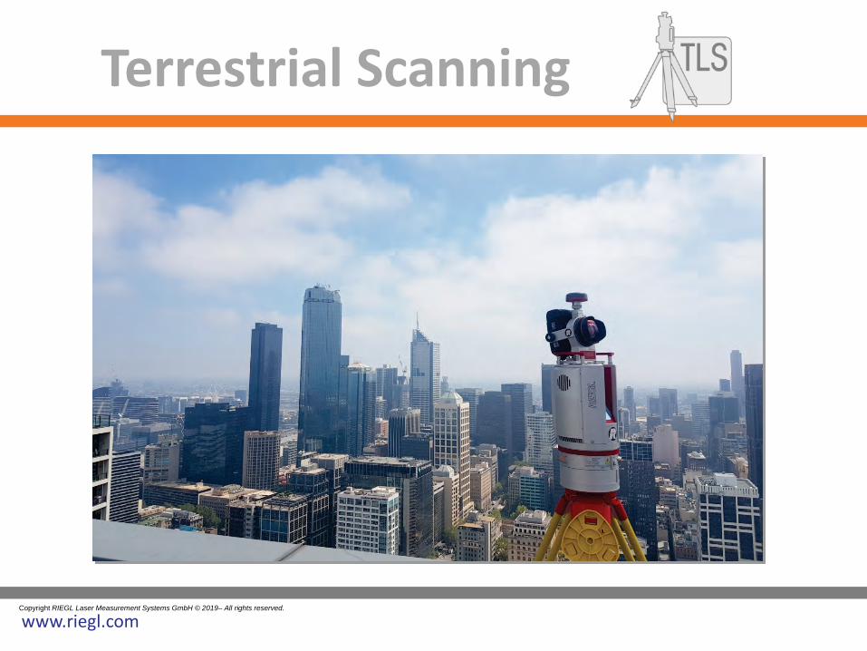
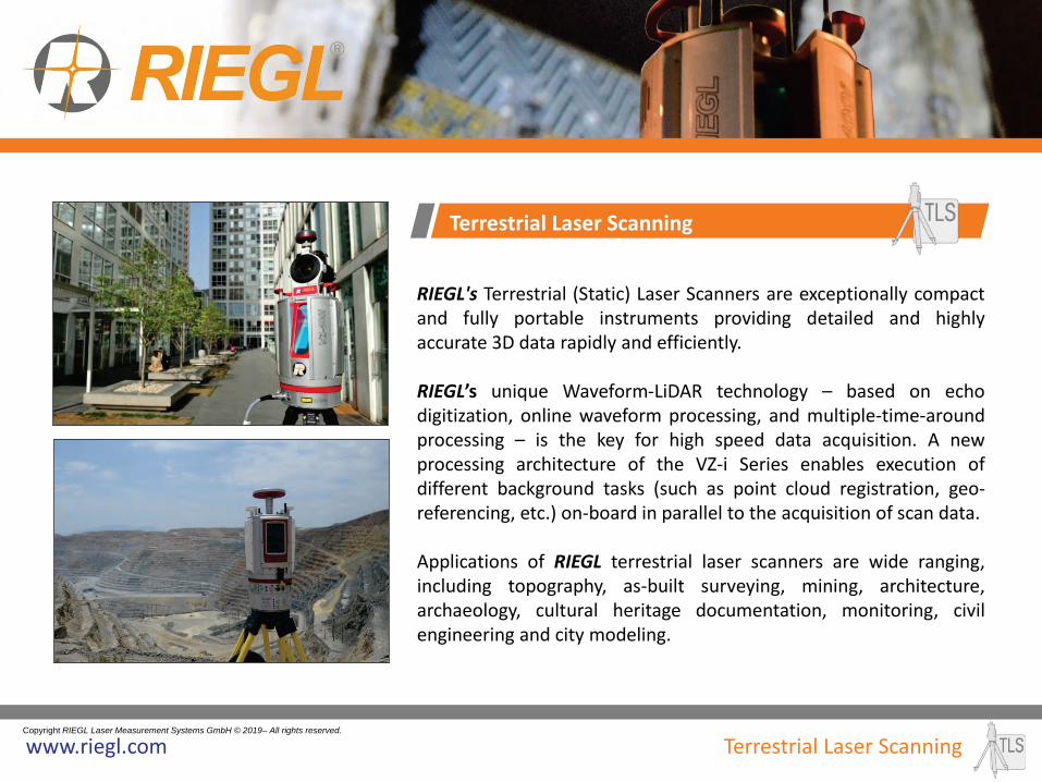
RIEGL's Terrestrial (Static) Laser Scanners are exceptionally compact and fully portable instruments providing detailed and highly accurate 3D data rapidly and efficiently. RIEGL’s unique Waveform-LiDAR technology – based on echo digitization, online waveform processing, and multiple-time-around processing – is the key for high speed data acquisition. A new processing architecture of the VZ-i Series enables execution of different background tasks (such as point cloud registration, geo-referencing, etc.) on-board in parallel to the acquisition of scan data. Applications of RIEGL terrestrial laser scanners are wide ranging, including topography, as-built surveying, mining, architecture, archaeology, cultural heritage documentation, monitoring, civil engineering and city modeling.
Ultra high-performance 3D terrestrial laser scanning systems • RIEGL Waveform-LiDAR technology • automatic registration during data acquisition • simultaneous image and scan data acquisition • cloud connectivity via LAN, Wi-Fi and LTE 4G/3G • remote control via app • customizable workflows • rugged design, fast set-up, user-friendly touch screen • optional camera, various built-in sensors • fully compatible with the RIEGL VMZ hybrid mobile mapping system • eye safe operation at laser class 1
RIEGL VZ-400i / VZ-2000i
• up to 1.2 million meas./sec • range up to 800 / 2,500 m • accuracy / precision: 5 / 3 mm
• range up to 4,000 m • accuracy 15 mm • Laser PRR up to 300 kHz, eyesafe Laser Class 1 • built-in calibrated digital camera
RIEGL VZ-6000
• range up to 6,000 m • accuracy 15 mm • Laser PRR up to 300 kHz, Laser Class 3B • exceptionally suited for measuring snowy and icy terrain • built-in calibrated digital camera
RIEGL VZ-Series
3D terrestrial laser scanners for very long ranges
Airborne (Kinematic) Laser Scanning is a rapid, highly accurate and efficient method of capturing 3D data of large areas, such as agricultural or forestry sites, urban areas, industrial plants, power line or rail-way corridors, etc. RIEGL offers various ingenious solutions optimally tailored to the missions‘ requirements – from single laser scanner engines to fully integrated laser scanning systems and well-developed turn-key solutions.
NEW RIEGL VQ-780 II Waveform Processing Scanner for Ultra Wide Area Mapping and High Productivity • online waveform processing
as well as smart and full waveform recording • excellent multiple target detection capability • excellent suppression of atmospheric clutter • Multiple-Time-Around (MTA) processing
of up to 35 pulses simultaneously in the air • high laser pulse repetition rate up to 2 MHz • up to 1.33 million measurements/sec
on the ground
broad effective swath width
RIEGL VUX-1LR • for airborne surveying from helicopters • Max. operating flight altitude 1,740 ft AGL • up to 750,000 meas./sec on the ground
RIEGL VQ-480 II / VQ-580 II Airborne Laser Scanning System at 1550nm / 1064 nm wavelength
• compact & lightweight design: ready for integration in helicopters, small aircrafts, or UAVs with higher payload capacity
• high accuracy ranging based on RIEGL Waveform-LiDAR technology
• wide filed of view of 75° • pulse repetition rate of up to 2MHz,
measurement rate up to 1,250,000 meas./sec • perfectly linear and parallel scan lines • interfaces for up to 5 optional cameras • mechanical and electrical interface
for IMU/GNSS integration • removeable data storage card CFast®
and integrated Solid State Disk (SSD) • compatible with stabilized platforms and even small hatches
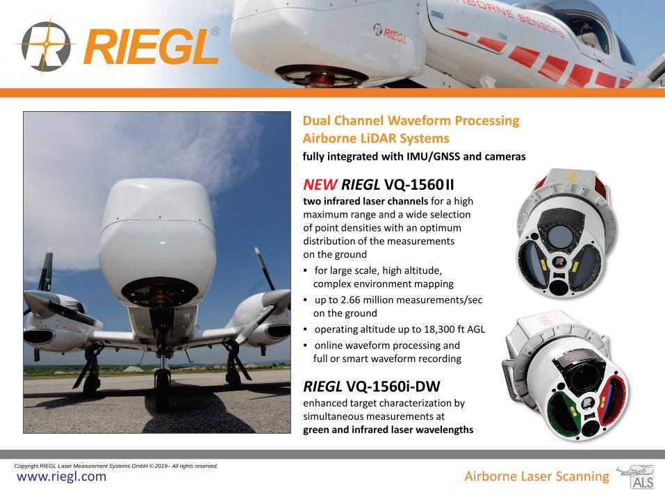
NEW RIEGL VQ-1560 II two infrared laser channels for a high maximum range and a wide selection of point densities with an optimum distribution of the measurements on the ground • for large scale, high altitude, complex environment mapping • up to 2.66 million measurements/sec on the ground • operating altitude up to 18,300 ft AGL • online waveform processing and full or smart waveform recording
RIEGL VQ-1560i-DW enhanced target characterization by simultaneous measurements at green and infrared laser wavelengths
Dual Channel Waveform Processing Airborne LiDAR Systems
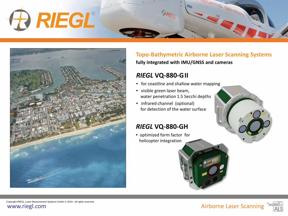
• for coastline and shallow water mapping • visible green laser beam, water penetration 1.5 Secchi depths • infrared channel (optional) for detection of the water surface
RIEGL VQ-880-GH • optimized form factor for helicopter integration
with Online Waveform Processing and Full Waveform Recording
RIEGL VQ-840-G
• compact and lightweight design • visible green laser beam, water penetration ≥ 2 Secchi depths • high spatial resolution due to measurement rate up to 200 kHz and high scanning speed of up to 100 scans/sec • integrated inertial navigation system (optional) • high-resolution digital camera or infrared laser rangefinder optional • for installation on various platforms including UAVs
Mobile (Kinematic) Laser Scanning enables rapid and efficient data acquisition from a variety of moving platforms, such as cars, railway vehicles, ships, boats, etc.
Mobile Laser Scanner
RIEGL VUX-1HA • compact, rugged, and lightweight design • easily mountable to whatsoever type of moving platform • high accuracy of 5 mm • up to 1,000,000 meas./sec • extremely high measurement speed
• 2 RIEGL VUX-1HA laser scanner and high accuracy IMU/GNSS unit fully integrated
• up to 2 MHz effective measurement rate • up to 500 scan lines/sec • 5 mm accuracy, 360° vertical field of view • user-friendly mounting • aerodynamically-shaped protective cover • camera interface for up to 9 optional cameras • flexible combination of different camera configurations
- high-sensitivity 5MP, 9MP and 12MP RIEGL cameras - FLIR Ladybug 5+ - DSLR camera such as Nikon D810 or Sony Alpha
NEW RIEGL VMX-2HA-BC (Basic Configuration)
• weight and size reduced version focusing on high-end scanning performance • with an optional spherical imaging system such as FLIR Ladybug® 5+ camera
RIEGL VMX-2HA High Speed, High Performance Dual Scanner Mobile Mapping System
RIEGL VMX-2HA equipped with RIEGL cameras
RIEGL VMX-2HA equipped with FLIR ladybug 5+ camera
• rugged measuring-head for reliable long-term operation in harsh environments equipped with 3 VUX-1HA laser scanners • 3MHz pulse repetition rate and 750 lines/sec resulting in up to 7000 pts/m2 in 3m range at 80 km/h platform speed • enables the capture of the complete rail corridor, including catenary systems, rail heads, and the complete periphery,
even signs orthogonal to running direction • optionally integrated camera system and open interfaces to various sensors • data export to Third-Party Rail-Processing Software Packages
RIEGL VMX-RAIL Triple Scanner Mobile Mapping System Specifically Designed for Track Mapping and Clearance Surveying
• IMU/GNSS unit, fully integrated to support RIEGL VZ-400i or VZ-2000i scanners for mobile (kinematic) data acquisition
• fast transition from tripod to mobile mount – high stability of boresight system calibration
• optional image data acquisition with fully integrated cameras
Mobile Mapping Systems
RIEGL VMQ-1HA High Speed, Single Scanner Mobile Mapping System
• 1 RIEGL VUX-1HA laser scanner and IMU/GNSS unit fully integrated
• up to 1 MHz effective measurement rate • up to 250 scan lines/sec • 360° vertical field of view • camera interface for up to 4 optional cameras • multiple swivel positions of the measuring head
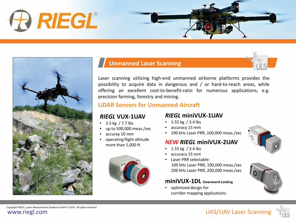
Laser scanning utilizing high-end unmanned airborne platforms provides the possibility to acquire data in dangerous and / or hard-to-reach areas, while offering an excellent cost-to-benefit-ratio for numerous applications, e.g. precision farming, forestry and mining.
LiDAR Sensors for Unmanned Aircraft RIEGL VUX-1UAV • 3.5 kg / 7.7 lbs • up to 500,000 meas./sec • accuray 10 mm • operating flight altitude
more than 1,000 ft
Unmanned Laser Scanning
RIEGL miniVUX-1UAV • 1.55 kg / 3.4 lbs • accuracy 15 mm • 100 kHz Laser PRR, 100,000 meas./sec
NEW RIEGL miniVUX-2UAV • 1.55 kg / 3.4 lbs • accuracy 15 mm • Laser PRR selectable: 100 kHz Laser PRR, 100,000 meas./sec 200 kHz Laser PRR, 200,000 meas./sec
miniVUX-1DL Downward-Looking
• optimized design for corridor mapping applications
• easily mountable to unmanned platforms (UAVs) or to helicopters, gyrocopters, and other small manned aircrafts
• laser pulse repetition rate up to 1.8 MHz • measurement rate up to 1,500,000 meas./sec • scan speed up to 400 lines/second • operating flight altitude up to 1,400m / 4,600 ft • field of view up to 75° • perfectly linear and parallel scan lines • cutting edge RIEGL technology providing:
• mechanical and electrical interface for optional INS/GNSS integration • interfaces for up to 4 optional cameras • scan data storage on internal 1 TByte SSD Memory
The RIEGL VUX-SYS is a complete laser scanning system of low weight and compact size for flexible use in kinematic applications. • fully integrated RIEGL VUX-1
Series LiDAR sensor • inertial measurement unit and
GPS/GLONASS receiver integrated • various mounting options for
highly flexible installation • operates up to 4 cameras • dependent on scanner and IMU/GNSS unit
used, the system can be used flexibly for different applications (e.g. for both, RiCOPTER and VMQ)
Laser Scanning System for Unmanned Aircraft
RIEGL VUX-SYS for RiCOPTER
RIEGL VUX-SYS installed in RiCOPTER • RIEGL VUX-1UAV LiDAR sensor, IMU/GNSS unit,
GNSS antenna, control unit, and 2 cameras fully integrated
• 10 mm accuracy • up to 350,000 meas./sec, 230° field of view
The RIEGL miniVUX-SYS is a complete miniaturized & lightweight laser scanning system of low weight and compact size for flexible use in UAV-based applications on a variety of UAV/UAS/RPAS.
• RIEGL miniVUX Series LiDAR sensor fully integrated • different IMU/GNSS options available • various mounting options for highly flexible installation • prepared for remote control via low-bandwidth data link • prepared for interfacing with optional RGB camera(s) and thermal imaging sensor(s) • Integration Kit 600 available for straight forward system integration with selected multi-rotor UAV types
Laser Scanning System for Unmanned Aircraft
RIEGL Integration Kit 600 add-on to the miniVUX-SYS coming with shock-absorbing mounting-kit, power supply module and cabling
RIEGL miniVUX-SYS with APX-15 UAV Delair DT26X fixed-wing integration example with RIEGL miniVUX-1DL LiDAR sensor equipped with APX-15 UAV
RIEGL miniVUX-SYS with APX-20 UAV RIEGL miniVUX-1UAV LiDAR sensor equipped with APX-20 UAV
UAV-based LiDAR Surveying System for Hydrographic Applications
BathyCopter
• RiCOPTER equipped with Bathymetric Depth Finder RIEGL BDF-1 (comprising of tilt compensator, an IMU/GNSS unit with antenna, a control unit and up to two external digital cameras) providing up to 1.5 Secchi depths measuring range
• ideally suited for generating profiles of inland water bodies • floating support for safe water landing and
take-off from water bodies • excellent performance even at adverse conditions
based on pre-detection averaging • highly accurate, reliable and informative bathymetric data
resulting from RIEGL’s proprietary hydrographic waveform processing
BathyCopter: RiCOPTER with fully integrated RIEGL BDF-1 and floating support
RIEGL offers powerful scanners and scanning solutions for various fields of industrial applications. All these are exceptionally compact, reliable, and provide highest performance and longevity even in harsh and demanding environments.
Protective Housings
PH-VUX • protective housing for RIEGL VUX-1 Series laser scanners • hermetically-sealed, with thermo-electric coolers and forced-air cooling
RIEGL PH-400i/2000i and RIEGL PH-4000/6000-SRH • rugged and robust industrial protective housing for RIEGL V-Line Terrestrial Laser Scanners • hermetically-sealed, with thermo-electric coolers and forced-air cooling • industrial standard connectors and supply cables • application-specific interface and software solutions
Laser Scanners
VZ-200 • 3D laser scanner for process automation of stackers and reclaimers, measurement of stock piles
and bulk material, surveying and monitoring in topography and mining
RiSOLVE „one touch“ solution for a rapid acquisition and registration of scan data and calibrated camera images by terrestrial RIEGL V-Line Laser Scanners, reduces field and post-processing time significantly
RiTLS Library
Terrestrial Laser Scanning Software Library for parameterization and control of RIEGL V-Line Scanners
RiMINING optimizing and simplifying scan data registration and processing workflow for open pit mining, offering, e.g. automatic extraction of breaklines
RiMTA automated resolution of range ambiguities
RiVLIB Interface Software to RIEGL‘s V-Line Scanner Series, providing library information for assisting software developers in integrating the instruments into customer specific systems
RIEGL Software for TERRESTRIAL and INDUSTRIAL Scanning
GeoSysManager 2.0 conversion of coordinates from one geodetic coordinate reference system to another
RiPRECISION software plug-in for RiPROCESS, performing adjustments of the trajectory to merge overlapping mobile/UAV based scan data acquired with RIEGL‘s V-Line laser scanning systems completely automatically, expediently, and rigorously
RiWORLD
coordinate transformation
RiHYDRO
airborne data processing software addon for commercial hydrographic and bathymetric surveying
GeoSysManager 2.0 conversion of coordinates from one geodetic coordinate reference system to another
RiANALYZE full waveform analysis of digitized echo signals


![cHnH ^ E_ T [Content_Types].xmlUT 9p V;p Vux T[O 0 ~7 ? . c / r`Uh](https://static.documents.pub/doc/80x56/5aa160917f8b9a436d8b8334/-chnh-e-t-contenttypesxmlut-9p-vp-vux-to-0-7-c-ruh.jpg)


