West Byron Urban Release Area Proposed zones and other planning controls and the Preliminary DCP This document summarises the planning process undertaken for the State Significant Site Study that has resulted in a proposed Land Use Plan and a Preliminary Development Control Plan. At the Department of Planning’s exhibition of the Study, which may occur late 2010 or early 2011, the details of this planning process and reports produced will be made available to stakeholders. The summary that follows outlines the main elements of the study, for your initial consideration. The zones and other planning controls for West Byron will be based on the NSW Government Standard Instrument. Byron Shire Council is also preparing its shirewide LEP in accordance with the Standard Instrument. After the land is rezoned, a detailed master plan will be prepared, and then applications can be lodged for subdivision and eventually for actual buildings. THE PLANNING PHASES FOR THE STATE SIGNIFICANT SITE STUDY PROCESS PHASE 1: APPLICATION TO THE DEPARTMENT OF PLANNING. InSeptember2009, theNSW MinisterforPlanning declaredthelandasapotential StateSignificant Site. Thismeanstheland issubject toaStateSignificant SiteStudythat will identifyzoningoptionsandotherdevelopment controls. The Department of PlanningissuedrequirementsfortheStateSignificant Sitestudyon3 November2009. PHASE 2: INVESTIGATION PHASE. Environmental andtechnical assessmentswereundertakenaswell asconsultationwithstakeholders(community, Council andStategovernment departments). Theexpert environmental andothertechnical assessmentscoveredacidsulfatesoils, odourfrom theSunnybrandChickenssite, Aboriginal archaeology, bushfire, civil engineering, economics, flooding, floraandfauna, marineecology, mosquitoes, social impact, traffic, trafficnoise, visual impact, water quality, urbandesign andplanning. Detailedreportsarebeingfinalisedandwill beavailableinPhase6 (exhibition). PHASE 3: DESIGN OF ZONING OPTIONS AND DEVELOPMENT CONTROLS FOR THE SITE. Theteam heldanurbandesign workshoptoinvestigatea rangeof designand planningoptions. Theworkshopbrought togetherkeyplanning, environmental and infrastructureconsultantsaswell aslandownersin acollaborativeenvironment toexchangeideasandtoestablishprinciplesand guidelinesfordevelopment. Theworkshopledparticipantsthroughamulti- disciplinaryassessment of siteconstraints, social andeconomicfactorsandopportunities. Thiswasfollowedbyanurbandesignprocessthat rangedfrom theregional perspective(thebigpicture) tothelocal scaledetailinglanduse, accessanddevelopment form. PHASE 4: REFINEMENT OF PROPOSED LAND USE PLAN THROUGH FEEDBACK FROM STAKEHOLDERS. Feedbackisbeingsought from the communityandotherstakeholders. Thismayleadtorefinement of theproposedLandUsePlanandtheproposedzonesbeforetheSSS studyissubmitted totheDepartment of Planning. All feedbackreceived inthisphasewill alsobereferredontotheDepartment of Planningfortheirassessment. PHASE 5: STUDY IS SUBMITTED TO THE DEPARTMENT OF PLANNING FOR ASSESSMENT. Thestudywill includeall theenvironmental andtechnical assessment reports, theproposedLandUsePlanandthepreliminaryDevelopment Control Plan(DCP). Thejobof thepreliminaryDCP istocapture informationacquired intheSSS study, but not reflectedintheformal SSS listing. PHASE 6: EXHIBITION OF DRAFT REZONING PROPOSAL FOR WEST BYRON BY DEPARTMENT OF PLANNING. ExhibitionbytheDepartment of Planning, invitingsubmissionsfrom thecommunityandotherstakeholders. Thiswill befollowedbyanassessment of submissionsbytheDepartment of PlanningandamendmentstothePlan if required. PHASE 7: DETERMINATION AND LISTING IN SCHEDULE 3 OF SEPP MAJOR PROJECTS AS A STATE SIGNIFICANT SITE. OncefinalisedthePlan becomeslisted inastatutorydocument, likeasite-specificLocal Environmental Plan. We are here
Transcript
West Byron Urban Release Area
Proposed zones and other planning controls and the
Preliminary DCP
This document summarises the planning process undertaken for the State Significant Site Study that
has resulted in a proposed Land Use Plan and a Preliminary Development Control Plan. At the
Department of Planning’s exhibition of the Study, which may occur late 2010 or early 2011, the
details of this planning process and reports produced will be made available to stakeholders. The
summary that follows outlines the main elements of the study, for your initial consideration.
The zones and other planning controls for West Byron will be based on the NSW Government
Standard Instrument. Byron Shire Council is also preparing its shirewide LEP in accordance with the
Standard Instrument. After the land is rezoned, a detailed master plan will be prepared, and then
applications can be lodged for subdivision and eventually for actual buildings.
THE PLANNING PHASES FOR THE STATE SIGNIFICANT SITE STUDY PROCESS
PHASE 1: APPLICATION TO THE DEPARTMENT OF PLANNING. In September 2009, the NSW Minister for Planning declared the land as a potential State Significant Site. This means the land is subject to a State Significant Site Study that will identify zoning options and other development controls. The Department of Planning issued requirements for the State Significant Site study on 3 November 2009.
PHASE 2: INVESTIGATION PHASE. Environmental and technical assessments were undertaken as well as consultation with stakeholders (community, Council and State government departments).
The expert environmental and other technical assessments covered acid sulfate soils, odour from the Sunnybrand Chickens site, Aboriginal archaeology, bushfire, civil engineering, economics, flooding, flora and fauna, marine ecology, mosquitoes, social impact, traffic, traffic noise, visual impact, water quality, urban design and planning. Detailed reports are being finalised and will be available in Phase 6 (exhibition).
PHASE 3: DESIGN OF ZONING OPTIONS AND DEVELOPMENT CONTROLS FOR THE SITE. The team held an urban design workshop to investigate a range of design and planning options. The workshop brought together key planning, environmental and infrastructure consultants as well as land owners in a collaborative environment to exchange ideas and to establish principles and guidelines for development. The workshop led participants through a multi-disciplinary assessment of site constraints, social and economic factors and opportunities. This was followed by an urban design process that ranged from the regional perspective (the big picture) to the local scale detailing land use, access and development form.
PHASE 4: REFINEMENT OF PROPOSED LAND USE PLAN THROUGH FEEDBACK FROM STAKEHOLDERS. Feedback is being sought from the community and other stakeholders. This may lead to refinement of the proposed Land Use Plan and the proposed zones before the SSS study is submitted to the Department of Planning. All feedback received in this phase will also be referred on to the Department of Planning for their assessment.
PHASE 5: STUDY IS SUBMITTED TO THE DEPARTMENT OF PLANNING FOR ASSESSMENT. The study will include all the environmental and technical assessment reports, the proposed Land Use Plan and the preliminary Development Control Plan (DCP). The job of the preliminary DCP is to capture information acquired in the SSS study, but not reflected in the formal SSS listing.
PHASE 6: EXHIBITION OF DRAFT REZONING PROPOSAL FOR WEST BYRON BY DEPARTMENT OF PLANNING. Exhibition by the Department of Planning, inviting submissions from the community and other stakeholders. This will be followed by an assessment of submissions by the Department of Planning and amendments to the Plan if required.
PHASE 7: DETERMINATION AND LISTING IN SCHEDULE 3 OF SEPP MAJOR PROJECTS AS A STATE SIGNIFICANT SITE. Once finalised the Plan becomes listed in a statutory document, like a site-specific Local Environmental Plan.
We are
here
PHASE 2 – INVESTIGATIONS ‐ KEY FINDINGS AND RECOMMENDATIONS A number of specialist background reports were prepared to inform the urban design work for the
SSS study. These are summarised in the following sections.
Acid Sulfate Soils
Acid sulfate soils are present across the entire site, with relatively higher risk areas identified in
the northeast and east parts of the site. The likelihood of disturbance is reduced because the site
will require filling, rather than excavation, to provide drainage. The need for an acid sulfate soil
management plan will be reviewed master planning and in the subdivision design stages. If the main
drain through the site is going to be modified, that work may need to be staged to reduce potential
impacts.
Acid sulfate soils are not an impediment to urban rezoning.
Acoustic Impacts:
The speed environment on Ewingsdale Road is a significant factor in determining development
conditions within the site. There are indications that the speed limit along the site frontage will
need to be reduced in the future, to a point west of the entry to the new sportsfields.
Another source of noise is the adjoining Sunnybrand Chicken site and its air‐conditioning units and
other industrial activity.
Mitigation measures for noise impacts include:
• Separation distances between noise sources and ‘sensitive receptors’ (dwellings)
• Solid structure/s (walls, mounds)
• Non‐residential uses in exposure zones (e.g. light industrial, home offices)
Air Quality:
The principal source of odour on the Sunnybrand site is the storage of live birds prior to slaughter
and processing. Birds are presently stored in two roofed areas that are open to the ambient wind
conditions. During operating hours, odour from the birds and from their waste accumulating on the
ground is emitted in plumes that travel with the prevailing wind direction. Emissions are influenced
by the wind speed, the number of birds present, and the state of the accumulated waste. Mitigation
measures include:
• Separation distances (from odour sources)
• Vegetated buffers
• Non‐residential uses in exposure zones (e.g. light industrial, home offices)
Archaeology:
Aboriginal stakeholders have been consulted. Based on their advice and field survey and
assessment, there are no cultural heritage constraints to rezoning of the study area for urban
development purposes.
However, to avoid or mitigate impacts of any future development on cultural heritage resources it
was concluded that, prior to development, subsurface archaeological testing should be undertaken
on and around two areas on the site. This will more securely assess their cultural heritage values
and define whether any parts of the site warrant conservation. If significant archaeological deposits
are identified, permanent protection and monitoring may be called for, in conjunction with further
Aboriginal stakeholder consultation.
Bushfire:
The site has moderate bushfire hazard levels, primarily due to extensive wetland communities to the
south. Bushfire risk within the site is significantly reduced as most vegetation has been significantly
cleared and any remaining areas of vegetation occur in small fragmented stands. The NSW guideline
“Planning For Bushfire Protection” requires several bushfire management strategies to be
addressed:
• Using perimeter roads;
• Building construction classification;
• Asset Protection Zones, depending on vegetation type and nature of development (mostly
15 or 20 metres for residential development);
• Secondary road accesses, rather than one road in and one road out.
Civil Engineering:
The main findings from engineering investigations are:
• Water, electricity & telecommunications are available to the site, according to the relevant
providers;
• Sewer capacity is available, based on calculations of existing and anticipated volumes of
sewage being treated at the Byron Sewage treatment plant;
• A water main for Byron Bay runs through the site;
• Optic fibre cable, sewer mains and water mains are located along Ewingsdale Road and
should be avoided where possible;
• Sunrise Boulevard is not suitable for an access roundabout to West Byron due to flooding,
acid sulfate soils and existing infrastructure.
Economics:
Investigations concluded that there was unlikely to be sufficient population to maintain a viable full‐
line supermarket at West Byron. However neighbourhood shops probably would be viable
depending upon population generated within the site and the extent and nature of their trade
catchment.
A commercial/neighbourhood centre located on the Ewingsdale Road frontage would obviously be
better for passing trade, but this location would not necessarily be ideal for residents within the
study area in terms of accessibility and the site may be compromised in terms of amenity impacts
(noise etc) from Ewingsdale Road. A more central location within the site on the major internal
movement network may be better for access for residents and should provide a “village centre”
identity. Any centre should be complimentary to existing centres in the locality.
Flooding:
Parts of the site are subject to flooding. Flood prone areas are categorised in terms of low, medium
and high hazard.
Development should be avoided in “high flood hazard” areas. Low hazard areas and many
intermediate hazard areas may be filled with no significant impacts, subject to confirmation by flood
modelling. Flood modelling indicates a higher sensitivity to filling in areas close to the bridge over
Belongil Creek compared to other areas further upstream, at the south and west of the site.
Flora & Fauna:
Comprehensive flora and fauna surveys and threatened species surveys have been completed. Parts
of the site contain vegetation and/or habitat of high conservation value and areas of importance for
threatened species. One threatened flora species and two Endangered Ecological Communities have
been recorded.
Where vegetation or habitat may require removal as part of future development of the site, there
are extensive opportunities for compensation via revegetation, restoration and enhancement
planting elsewhere on the site.
A planting program will provide a net gain of Koala habitat and provide linkages between identified
Koala activity areas to the north and south.
The ecological values of the site can be maintained and improved by avoiding development of high
conservation areas, mitigating environmental impacts, and compensating for vegetation/habitat
losses by the retention and restoration of similar habitat.
Planning:
The NSW planning system requires consideration of many planning and design guidelines including:
• Coastal Design Guidelines
• North Coast Urban Design Guidelines
• Department of Housing regional housing analysis
These documents provide consistent messages on a range of development issues, including:
• Balancing ecological, social and economic aspects to achieve sustainable development.
• Designing for walkable communities, using a grid street system and reducing the use of cul‐
de sacs (these create longer travel distances and increase the use of cars).
• The need to provide small lots and small dwellings in response to changing and diversifying
lifestyle choices and affordability.
• Creating a neighbourhood focus rather than generic development.
• Planning for parks and public transport.
For the current phase of the planning work, the general residential areas are assumed as having an
average density of 18 dwellings per hectare. The live/work at area at the west approximately 10‐12
dwellings per hectare, and the neighbourhood node at the east would have an average of 25
dwellings per hectare. In comparison, existing areas like Sunrise Beach and Baywood Chase have
relatively low residential densities of about 10 to 12 dwellings per hectare due to the predominance
of large detached houses on large lots.
A density of 18 dwellings per hectare translates to approximately 850 dwellings in West Byron .
Based on demographic trends, this means housing for between 1,200 and 1,500 people.
Public Land:
The main drain which runs diagonally north/west to south east through the site is Crown land,
managed by the Belongil Swamp Drainage Union. It may be possible to modify the drain in some
places, so that it has a more natural appearance with gentler side banks and some native vegetation.
There is a road reserve along the frontage to Belongil Creek. This edge represents an opportunity for
greater public access via low impact facilities such as elevated boardwalks.
The existing road reserve for Melaleuca Drive does not need to be modified, although the access
intersection to Ewingsdale Road may need to be closed when the Bayshore Drive roundabout is
built. A road reserve along the east side of Belongil Fields contains a large water main and significant
vegetation, and should remain as public land.
It is expected that areas of community open space and urban bushland within urban areas of the
development will be dedicated to Council as public land.
Marine Ecology:
A number of drains run through the study area. These drains carry water from the Byron Bay
Industrial Estate and from the west Byron sewage treatment plant. One of these drains, the Union
Drain, is responsible for draining farmland within the Belongil‐Cumbebin catchment.
Recommendations to maintain water quality in Belongil Creek include minimum buffers between the
creek and any proposed development; habitat restoration including weed control along drainage
lines; improved culverts over water crossings; water quality monitoring at the inlet and outlet of the
Industrial Estate drain where it passes through the study area; and controlling public access to the
Belongil Creek.
Mosquitoes:
Scientific sampling and historical records identified over 30 mosquito species associated with the
study site and surrounding areas. The most abundant mosquitoes were those associated with the
Melaleuca forest habitats. The results indicate that the risk of nuisance‐biting impacts are not
significantly greater than other residential areas of the Byron Shire.
Some mosquito activity should be expected in outdoor areas, but the entry of mosquitoes into
buildings can often have significantly greater nuisance impacts, so insect screens should be fitted to
windows and doors. Consideration should be given to minimizing the potential of onsite mosquito
habitats associated with buildings, particularly rainwater tanks.
Social Impact:
Based on the likely population profile and the location of the proposed residential precinct of the
development, it would be appropriate for the West Byron Land Release be treated as an extension
to the development to the north – the Sunrise Beach residential area and the Arts & Industry estate.
Safe pedestrian connections should be made into this area, across Ewingsdale Road.
There is very little spare capacity for child care in the locality, and additional demands will arise if
West Byron is more affordable for young families. The needs of young people are expected to be
met within the wider community. The Sports Complex, in particular, will be in close proximity to the
site with its cycle and skate facilities.
Poor transport is a significant local issue for the Byron Shire’s young people. West Byron should
incorporate bus routes and cycle infrastructure.
The residential precinct of the development will provide increased demand for community
development facilities and services. This will include community meeting spaces, which will be met
in part through appropriately designed public domain. There is a need for a social focus or hub for
the new community. This could comprise part of a higher density mixed use development which
integrates commercial, recreation and tourism uses. There will be a need for some complementary
and neighbourhood‐level facilities on the site. This could entail a café, takeaway food outlets,
community meeting spaces etc.
It is not anticipated that the proposed development will make any significant demands on ageing
and disability facilities and services in the medium term. A component of the development could
however provide Seniors Living housing.
Traffic:
Traffic modelling indicates that both the min‐bypass and the longer bypass are already needed in
Byron Bay, and that Ewingsdale Road will need the following works by the year 2028:
• 4‐lanes between the proposed sport fields and Sunrise Boulevard
• The Bayshore Drive / Ewingsdale Road intersection will need to be a roundabout
• Access to West Byron will need to be via roundabouts. Bayshore Drive is likely on the west
part of the site but to the east, there are complications at the Sunrise Boulevarde
intersection so the entry to the School of Audio Engineering is likely to be the safest and
most appropriate option.
Visual and Landscape Quality:
The scenic quality of the site is defined by its greenness and its openness. However the naturalness
of the site is compromised by grazing and the low quality of built form. Areas that are the most
sensitive to changes are those adjacent to or in the foreground of the visual catchment. The highest
impacts will predominantly be on localised or foreground views along Ewingsdale Road.
Visual impact can be addressed by locating streets along view lines to minimise the partitioning of
views and maintaining an open character.
To mitigate the impact of acoustic barriers, they should not form a homogeneous and continuous
screen to the entire length of the Ewingsdale Road frontage. Consideration will be given to barriers
being installed at various setbacks, constructed of various materials, and having a varied
appearance. Enough space should be given for dense vegetative screening and pedestrian access.
Where no acoustic barriers are proposed, and building setbacks or building design are used to
provide acoustic buffering to dwellings, a high quality of design should be applied to landscape areas
and buildings.
Water Management:
Few natural waterways exist on the site, and the hydrology and hydrogeology are fundamentally
governed by the sandy soils and unconfined shallow aquifer. The relatively large Industrial Estate
Drain bisects the site and carries untreated and unmanaged urban runoff. The development of West
Byron is unlikely to increase the requirement for artificial estuary opening to the ocean. Buffer
zones and integration of treatment systems with biodiversity are appropriate in some locations.
A range of Water Sensitive Urban Design (WSUD) strategies and devices have been assessed, using
the widely accepted MUSIC Model. A number of treatment train scenarios were modelled to assess
the impacts on water quantity and quality and to determine a reasonable sequence of treatment
train elements for the West Byron site at this stage of planning.
Modelling indicated that the installation of rain water tanks to supply non‐potable indoor and
garden demand, and the installation of swales, wetlands and infiltration systems resulted in the
most effective treatment train. No offsite water supply is needed to meet the majority of household
demand for non‐potable water. A relatively small pond storage could supply treated stormwater for
open space irrigation.
Wetlands offer the best way of integrating surrounding biodiversity with on‐site biodiversity.
Bioretention systems would be suitable for some areas of the site.
PHASE 3 – DESIGN OF ZONING OPTIONS AND DEVELOPMENT CONTROLS ‐ THE URBAN DESIGN
PROCESS The results of the various studies were considered in the framework established by Department of
Planning’s SSS study specifications and various urban design guidelines. An in‐house Enquiry by
Design (EbD) Workshop was used to assimilate the environmental, social and economic factors and
to investigate a range of design and planning options. The EbD Workshop brought together key
planning, environmental and infrastructure consultants in a collaborative environment to exchange
ideas and to establish principles and guidelines for sustainable development. A multi‐disciplinary
assessment of site constraints and opportunities was followed by an iterative urban design process
that assessed the land from the regional perspective (the big picture) to the local and micro‐scale,
considering diverse development types, access, connectivity, the relationship between development
and the natural environment, and built form.
The urban design process focussed on the best development outcomes for the site, and those
outcomes were later converted into zones and other planning controls. The proposed land use zones
are described in the following section.
PHASE 4 – PROPOSED LAND USE PLAN AND PRELIMINARY DEVELOPMENT CONTROLS The proposed zones for the land are described below. We are seeking feedback in this phase on
whether the proposed zone types and locations make the best of this land resource.
Conservation areas – Zone: E2 Environmental Conservation A large area of land along Belongil Creek has been identified for revegetation. This revegetation will provide additional
habitat for threatened species and wildlife movement. It will connect with natural watercourses that flow from internal
parts of the site into Belongil Creek. Other areas of environmental significance include wetlands at the southern edges, and
threatened species habitat at the south (wallum froglet) and southeast (blossom bat).
The long term ownership and management of these areas will be negotiated with Council and State authorities, but this
does not affect the zoning.
Urban bushland ‐ Zone: E3 Environmental Management Within the site, large mature native trees will be conserved as urban bushland in areas of open space. Many of the trees
are in natural drainage areas which can be used as part of the urban stormwater drainage system. Some of the urban
bushland will require narrow lanes or paths to make connections between the different urban areas.
Light Industry area ‐ Zone: IN2 Light Industry This area is envisaged as being similar to the recent developments in the Arts and Industry estate, west of Bayshore Drive.
It would be an area without residents, due to the possibility of odour and machinery noise from the Sunnybrand Chickens
site. Buildings will have to be designed to avoid those impacts.
Tourism areas ‐ Zone: SP3 Tourist The area at the southwest contains existing tourism and recreational activities, namely the “Planula” bed and breakfast
and “Temple Byron.” A proper next to Ewingsdale Road contains a small factory that produces chocolate‐coated
macadamia nuts. It is proposed that this activity be made a tourism attraction. If the confectionery activity ceases, the site
would still be appropriate for tourist accommodation.
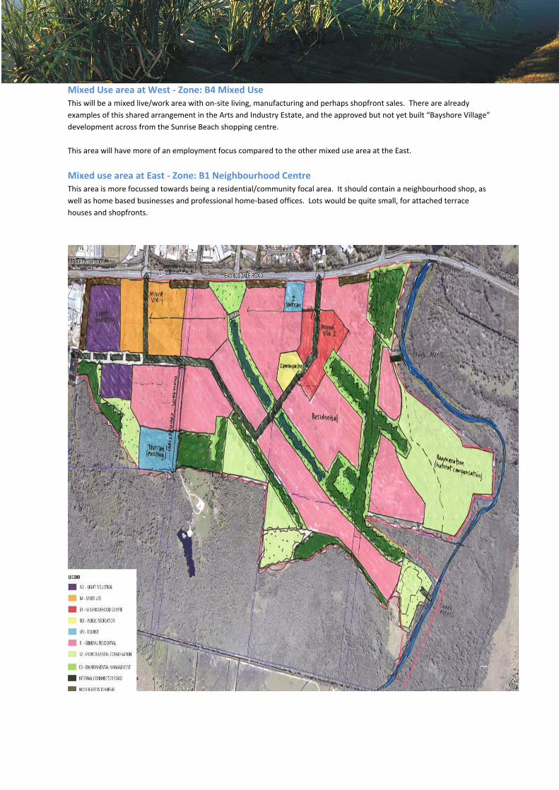
Mixed Use area at West ‐ Zone: B4 Mixed Use This will be a mixed live/work area with on‐site living, manufacturing and perhaps shopfront sales. There are already
examples of this shared arrangement in the Arts and Industry Estate, and the approved but not yet built “Bayshore Village”
development across from the Sunrise Beach shopping centre.
This area will have more of an employment focus compared to the other mixed use area at the East.
Mixed use area at East ‐ Zone: B1 Neighbourhood Centre This area is more focussed towards being a residential/community focal area. It should contain a neighbourhood shop, as
well as home based businesses and professional home‐based offices. Lots would be quite small, for attached terrace
houses and shopfronts.
Central area park ‐ Zone: RE1 Public Recreation This will be a multi‐use active open space area, suitable for tennis courts and other sports facilities. It is centrally located
and, within easy walking distance for all residents. The detail of the facilities to go in this park will be worked out in a future
master plan and open space plan, in consultation with Council and the community.
General residential areas ‐ Zone: R1 General Residential The residential areas will contain a mixture of different types of housing including terrace houses, courtyard lots, duplexes,
units and conventional houses. Large lots would be appropriate at the southwest, near the Planula B&B and Temple Byron,
but this does not need a different zone.
A future master plan will go into more detail about the type and density of development in different parts of the site.
Higher densities should be focussed closer to the neighbourhood centre and park, and along the main internal bus route.
In addition to zones, the State Significant Site listing for West Byron will also include:
Building height limits
Exempt and complying development
The need for a detailed DCP to be prepared prior to development
Miscellaneous planning controls
Building height:
The building height limit for West Byron will be the same as the rest of Byron Shire. This is set by the
Byron Local Environmental Plan at 9.0 metres.
Exempt and Complying Development:
Rather than inventing a whole new set of exempt and complying development rules for West Byron,
the planning controls will refer to an existing set of standards in a State Environmental Planning
Policy that is already in use in many other parts of the State (Byron Shire has its own exempt
development controls in DCP 16).
“Exempt development” classification allows for small incidental developments to be built without
needing development approval – things like garden sheds and small satellite dishes.
“Complying development” classification allows houses to be approved and built without a
Development Application if they comply with specified criteria like height, floor area, setbacks and
landscaped areas. It is envisaged that the majority of houses in West Byron would be complying
development under the Housing Code. Anyone wanting to build a house that goes outside the Code
will need to lodge a Development Application.
Exempt and complying development for West Byron will as per SEPP Exempt and Complying
Development Codes.
Miscellaneous planning controls:
Apart from zones, the NSW Standard Instrument contains many other planning controls or clauses.
The Standard Instrument continues to evolve, with clauses being modified or new clauses added in.
As it stands, there are several standard clauses that would be appropriate for West Byron, which
would need to be addressed in development applications:
2.6BB – Temporary use of land: This allows for markets and the like.
5.4 – Controls on specific uses such as:
maximum number of guest bedrooms in a bed and breakfast
maximum floor space for home businesses
maximum size of a neighbourhood shop
5.5 – Development in the NSW coastal zone: Most of West Byron is in the NSW coastal zone. This
clause requires consideration of a lot of environmental and design issues due to the sensitivity of
coastal areas.
5.9 – Preservation of trees: Similar to a tree preservation order.
6.3 – Development control plan: This clause will require a detailed DCP to be prepared before
subdivision or development can be approved. This DCP will need to include details of:
• Transport planning
• Landscaping strategy
• Active and passive recreation areas
• Stormwater controls
• Response to natural hazards
• Measures to encourage higher density living close to public transport and open space, and
to achieve development density targets
• Urban design and development controls
7.3 – Flood planning: requires assessment of how flooding may affect development, and how
development (e.g. filling) may affect flooding. This could include a map of the “flood planning area”
based on sophisticated flood modelling.
The NSW Department of Planning has recently proposed standard clauses pertaining to “riparian
land and waterways” and “biodiversity” although these are yet to be adopted.
THE PRELIMINARY DCP
The State Significant Site study will contain a lot of useful information, but not all of that information
can be reflected in zones and clauses. The Preliminary DCP will provide a place to “park” ideas so
that they are available as a reference for future planning work. At this stage, it is proposed that the
Preliminary DCP will include:
1. Desired Future Character Statement – a plain English description of the West Byron
development and its built, economic, social and natural environment
2. Location of access roundabouts at Bayshore Drive and in front of Belongil Fields
3. Conceptual route of internal connector road between access roundabouts
4. Plans illustrating closure of Melaleuca Drive intersection with Ewingsdale Road, when the
new internal connector road is built
5. Staging of infrastructure as the development rolls out
6. Designing the main connector road to take buses and bus stops
7. A cycleway along the south side of Ewingsdale Road, connecting the town track with the
Ewingsdale track
8. Different ways of managing traffic noise
9. Estimated dwelling yield and population, based on 18 dwellings per hectare in the general
residential areas and residential living in the mixed use areas
10. Information about the population necessary to support local facilities and neighbourhood
shop/s
11. Visual sensitivity and landscape planning principles
12. Designing the streetscape and facilities for different demographic groups
13. Likely minimum floor levels (due to flooding) and alternatives to slab‐on‐ground
construction (e.g. pier/pole footings)
14. Water Sensitive Urban Design calculations regarding rainwater tanks and dual reticulation of
treated wastewater from the Byron Bay sewage treatment plant
15. Conceptual stormwater treatment systems and areas
16. Building design adaptations to minimise mosquito nuisance
17. Ideas for modifying the main drain to make it a feature and improve its water quality
18. Ideas for different types of housing – terrace houses, courtyard housing, small lots, etc.
19. Ideas for adaptable housing – designing for different households and occupants
20. On‐street car parking for home businesses
21. Basic development criteria for development that is outside the NSW Housing Code
22. Internal road & pedestrian/cycle connections through open space & urban bushland areas
23. References to urban design documents, e.g:
Coastal Design Guidelines
North Coast Urban Design Guidelines
Planning for Bushfire Protection
24. References to Council policies, e.g. public art
The information in the Preliminary DCP will be at a conceptual level, and will be superseded by more
detailed work in the future, after the land is rezoned.
This document was produced by Land Partners, planning consultants for this project.