40
West Fork San Jacinto Watershed Greenprint
West Fork San Jacinto Watershed Greenprint


Printed on 100% recycled paper. © 2016 The Trust for Public Land.
West Fork San Jacinto Watershed Greenprint
July 2016

The Trust for Public Land creates parks
and protects land for people,
ensuring healthy, livable communities
for generations to come.
tpl.org

west fork san jacinto watershed greenprint 3
Table of contents
Preface ....................................................................................................................................... 4
Executive summary .................................................................................................................. 5
Introduction .............................................................................................................................. 7
Study area ............................................................................................................................... 11
Community engagement and project timeline ................................................................ 17
Mapping conservation values .............................................................................................. 19
Action plan ............................................................................................................................. 25
Funding opportunities .......................................................................................................... 29
Conclusion .............................................................................................................................. 32
Participants ............................................................................................................................. 33
Online appendices
appendix 1: Criteria matrix
appendix 2: References
appendix 3: Meeting summaries
appendix 4: Conservation finance resource options report
appendix 5: Montgomery county telephone poll results

4 west fork san jacinto watershed greenprint
AcknowledgmentsThe Trust for Public Land gratefully acknowledges the many individuals and organizations that contributed their time and energy to the creation of the West Fork San Jacinto Watershed Green-print. The Houston-Galveston Area Council was a wonderful partner and co-convener, bringing local expertise and a deep commitment to improving watershed health. Enormous thanks as well to the San Jacinto River Authority for its active participation in this process and for hosting all of our Greenprint meetings.
This Greenprint was made possible by support from Houston Endowment, the Mitchell Founda-tion, and the Powell Foundation. Nearly 30 people participated in interviews for this project, over 60 attended stakeholder meetings, and 18 provided local knowledge and technical expertise for our mapping efforts as members of the technical advisory team. See page 33 (Participants) for a full list of participants.
Project PartnersThe Trust for Public Land conserves land for people to enjoy as parks, gardens, and other natural places, ensuring livable communities for generations to come.
Houston-Galveston Area Council is the regional planning organization through which local governments consider issues and cooperate in solving area wide problems.
Project StaffAmy Wilson Morris, PhD, Project Manager Fred Gifford, GIS Lead
Preface
For copies of this Greenprint or for more information, please contact:
Greenprints The Trust for Public Land 101 Montgomery Street, Suite 900 San Francisco, CA 94104 [email protected]

west fork san jacinto watershed greenprint 5
THE TRUST FOR PUBLIC LAND WORKED with the Houston-Galveston Area Council (H-GAC) and a diverse group of stakeholders to develop the West Fork San Jacinto Watershed Greenprint. Through community engagement and state-of-the-art computer modeling, the Greenprint blends community priorities with science and research to identify lands with the highest value for voluntary conservation.
Work on this Greenprint began in the spring of 2015, and the Greenprint was finalized in the summer of 2016. The goals of the Green-print are to (1) Protect water quality and (2) Provide access to water-based recreation. The Overall Greenprint priorities map (page 24) highlights over 101,000 acres that are the highest priority for voluntary conservation because they would best meet these goals. The Greenprint consists of a set of prioritized maps and related strategies for action, that can guide local communities in protecting water-ways and open space in order to ensure quality of life, clean water, and economic health.
The Greenprint highlights areas for strategic voluntary conservation and for thoughtful recreation access. The Greenprint partners respect private property rights and recognize the critical importance of working lands in the study area and their stewardship by ranchers
and farmers, most of whom are deeply committed to maintaining the unique environ-ment and rural culture of the West Fork San Jacinto, Lake Creek, and Lake Conroe Water-sheds. While public recreational access can provide important opportunities for physical activity and connecting to the outdoors, this access must be well planned and maintained—and developed through engagement with and respect for longtime landowners and others who may be impacted.
Please note that while the Greenprint title refers to the “West Fork San Jacinto Watershed,” the study area encompasses the Lake Creek and Lake Conroe Watersheds, both of which connect to the West Fork San Jacinto River. The study area is shown in Figure 1.
Executive summary

6 west fork san jacinto watershed greenprint
suzan
ne sim
pson
Cypress slough within our Bender Preserve on the West Fork San Jacinto

west fork san jacinto watershed greenprint 7
“People want clean water, but they may not know where it comes from. Forested watersheds provide the cleanest water.”
—STEVE HUPP, BAYOU PRESERVATION ASSOCIATION
“This Greenprint is critical because increased development is inevitable, and we need to work with willing property owners now to protect land. We are running out of time.”
—RICHARD CHAPIN, MS4 PERMIT COORDINATOR FOR THE CITY OF HOUSTON
THE REGION SURROUNDING THE WEST FORK of the San Jacinto River is rich in working lands, ecological diversity, and rural and small-town culture. The study area for this Greenprint includes portions of three counties: Mont-gomery, Walker, and Grimes. Though all three counties include rural areas, they are developing quickly, and Montgomery County is one of the fastest-growing regions in the United States. The rivers, bayous, lakes, and watersheds in the study area are critical to local quality of life, and watershed lands play a crucial role in protecting the drinking water of residents throughout the region, including the city of Houston to the south.
The watersheds in the study area are expe-riencing rapid urbanization. There are trade-offs between accommodating develop-ment and population growth and preserving water quality. New development increases
stormwater runoff, which decreases water quality and threatens vulnerable water resources. Fortunately, it is possible to accom-modate some growth while avoiding most of these negative impacts. With careful plan-ning, strategically located parks, trails, and open space can provide buffers that naturally filter and slow runoff while providing valuable amenities to local residents. Well-managed working lands, such as farms and ranches, can also play a major role in protecting water quality and reducing the impacts of development.
In this Greenprint, local stakeholders came together to develop a strategic conservation vision that will:
1. Help the communities in the study area plan for a future that balances devel-opment pressures with protection of important resources, particularly water quality; and
2. Help foster a strong foundation for economic growth by setting priorities for preserving natural and recreational resources that are critical to local quality of life.
This vision is important because healthy lakes, streams, watersheds, and open spaces are more than just places to fish, swim, and enjoy the outdoors; they are essential to maintaining high-quality sources for drinking water and for maintaining the rural and small-town char-acter of the region.
Introduction

8 west fork san jacinto watershed greenprint
What is a Greenprint?Greenprints are community-driven conser-vation plans. Through Greenprinting, communities make informed decisions about protecting important resources, including drinking water, open space, and working lands. The Greenprinting process helps stakeholders work toward common goals using facilitated community engagement and state-of-the-art mapping methodologies and software. By determining where the greatest number of community goals can be met through conservation, Greenprint maps iden-tify the areas that would get “the most bang for the conservation buck.”
Ultimately, Greenprinting involves defining a conservation vision, securing funding, acquiring key lands (or conservation easements on those lands) from willing land-owners, and stewarding protected lands over time. The goal of a Greenprint is to facilitate practical, voluntary land conservation—bringing many voices into the conversation, employing the best technology available, and taking steps to ensure that implementation
is effective. This Greenprint builds on the conservation efforts of local groups and on watershed protection planning efforts by H-GAC and the San Jacinto River Authority.
Greenprints involve the following steps:
1. Constituency building and community outreach—reaching out to and convening stakeholders, identifying community values, establishing conservation criteria
2. Data gathering and analysis—under-standing existing conditions, assembling local GIS data, creating GIS models, ranking goals and criteria, translating models into opportunity maps
3. Implementation strategies—identifying practical strategies for implementation, developing an action plan
What is voluntary land conservation? The purpose of the Greenprint is to guide voluntary land conservation. This means purchasing privately owned land from willing landowners through voluntary “fee simple” acquisition or placing conservation easements
a greenprint is not:
• A map of land use prohibitions• Determined by just a few
perspectives• Limited to protecting wildlife• Related to condemning or taking
land/private property
a greenprint is:
• A set of tools (including interactive maps)
• A process to identify opportunities to meet multiple community goals
• A way to prioritize areas for voluntary, market-based conservation
west fork san jacinto watershed greenprint 9
on selected lands. Organizations like local land trusts and national groups such as The Trust for Public Land help willing landowners who are interested in selling or donating property (or partial interests in their property) to do that while protecting land from development. These voluntary transactions can be a win-win approach to conservation in which lands with important conservation values are perma-nently protected and willing landowners are compensated for forgoing development and other high-impact uses of their land.
A conservation easement is an agreement to give up some of the rights associated with a property (for example, the rights to subdivide and develop it), while enabling landowners to retain ownership of the land and pass it on to heirs if they choose. Conservation easements can help landowners continue to use a prop-erty as working land for farming, ranching, or
forestry. Conservation easements are tailored to the unique circumstances of each property. Often conservation easements are purchased from landowners using public funds. When landowners donate a conservation easement, they are generally eligible to receive tax benefits.
What is source water protection?Source water protection means preserving the areas that provide our drinking water. Water-ways serve many environmental, economic, recreational, and aesthetic purposes that can be undermined by poor water quality. One of the most important purposes of waterways is providing drinking water.
Rapid population growth and sprawling devel-opment threaten the watershed lands that provide and protect regional and local water supplies. In fact, the fastest-growing threat
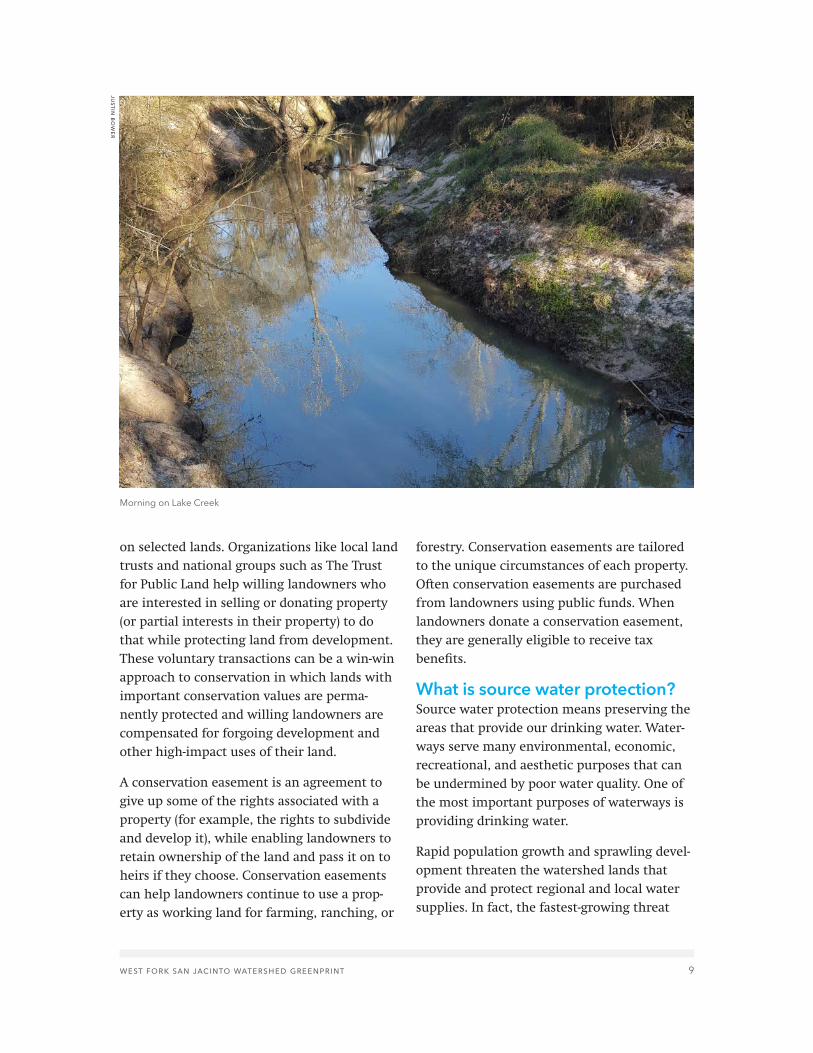
Morning on Lake Creek
justin
bow
er

10 west fork san jacinto watershed greenprint
to drinking water quality is pollution related to development. Polluted runoff from roads, parking lots, and subdivisions often contains oil, toxic metals, pesticides, sediment, nutri-ents, and other contaminants. As a result, it is important to preserve land that drains into lakes, rivers, streams, reservoirs, and ground-water. Land conservation is a powerful tool for protection of drinking water resources. The most important areas for protecting water quality are forestlands, wetlands, natural grasslands, steep slopes, land close to or encompassing small streams, and land with erodible soils.
Forests, wetlands, and natural grasslands play a critical role in protecting waterways by absorbing and filtering water. These areas prevent surface water runoff by slowing water flow and help filter out sediment, nutrients, and other pollutants. Forests may absorb and filter water at a rate 10 to 15 times higher than grass turf and 40 times higher than a plowed field. When forests remove nutrients from runoff, those nutrients are stored as leaves and wood in growing trees. Bacteria in the forest floor also remove nitrates from water. Vegetation in and along the floodplains of streams and rivers absorbs water and nutrients and plays particularly important roles during storms. Wetlands are spectacu-larly efficient at retaining water and removing nutrients and toxins.
Guiding principlesThe West Fork San Jacinto Watershed Green-print was guided by these principles and
core values, drafted by project partners and affirmed by the Greenprint stakeholders.
• Programs intended to enhance conserva-tion efforts must be based on local values and priorities. Our local natural, recre-ational, agricultural, and open space areas are unique.
• Residents value our local agricultural heri-tage. We encourage conservation efforts aimed at protecting agriculture.
• Surrounding beauty, recreational opportu-nities, and open spaces all play a vital role in making our area a desirable place to live and work. Conservation can promote viable agriculture; increase property values; attract ecotourism; and provide income to individual landowners through incentive-based conservation.
• Greenprint partners only support conserva-tion efforts with willing landowners. We do not support the use of eminent domain for conservation.
• We respect private property rights.
Vision statementStakeholders and project partners agreed on this vision for the Greenprint:
Our vision is a region where the vast majority of the riparian areas and floodplains that feed our waters are voluntarily protected, through strategies that protect landowner rights, so that residents and the environment can thrive as the region grows.

west fork san jacinto watershed greenprint 11
“Green space is green space . . . both ecologically and economi-cally. Economically it provides an attractive draw to businesses who want good places to work and for their employees. It also economically protects those same businesses and their employees’ families when the waters rise.”
—HARRIS COUNTY COMMISSIONER JACK CAGLE, HOUSTON CHRONICLE, APRIL 20, 2016
THE STUDY AREA FOR THIS GREENPRINT covers the West Fork San Jacinto, Lake Creek, and Lake Conroe Watersheds, all of which are part of the larger Lake Houston Watershed. It also covers portions of three counties: Mont-gomery, Walker, and Grimes. Collectively, this report refers to all three watersheds in the study area as the West Fork San Jacinto River Watershed because all three watersheds feed into the West Fork of the San Jacinto River. The watersheds in the study area are critical to the drinking water quality in the region and contain crucial working lands and open space. The study area is shown in Figure 1. The study area includes 864,135 acres, of which 500,237 acres are in Montgomery County, 224,965 in Walker County, and 138,933 in Grimes County. Lake Conroe is part of the study area, and the West Fork San Jacinto River feeds into Lake Houston, which is northeast of downtown Houston and supplies 20 percent of the city’s drinking water.
Waterbodies and watershedssan jacinto river. The San Jacinto River, including its east and west forks, extends approximately 187 miles from Walker County to the Gulf of Mexico. The drainage area for the river encompasses approximately 4,000 square miles in Walker, Montgomery, Liberty, San Jacinto, and Harris Counties. The San Jacinto River was named one of the ten most endangered rivers in 2006 because of habitat damage caused by sand and gravel dredging and watershed development.
west fork san jacinto river watershed. The 90-mile-long West Fork of the San Jacinto River flows south through Montgomery County and western Sam Houston National Forest and feeds Lake Conroe. The West Fork then merges with the 69-mile-long East Fork of the San Jacinto River at the northern rim of Lake Houston in Harris County. Downstream from Lake Conroe, the West Fork San Jacinto River flows through Montgomery and Harris Counties before becoming one of several streams impounded by Lake Houston. Land cover within the watershed is predominately hay pastures and mixed forest. Conroe and the surrounding cities consist of a mix of land covers, ranging from open spaces to high-density development.
lake houston. Lake Houston was created in 1955 by the City of Houston through the damming of the West Fork and East Fork of the San Jacinto River, creating a 12,240-acre reservoir. Because it is near Houston, it also experiences a great deal of recreational use.
Study area

12 west fork san jacinto watershed greenprint
figure 1 Special thanks to the following data provider: Bayou Land Conservancy Copyright © The Trust for Public Land. The Trust for Public Land and The Trust for Public Land logo are federally registered marks of The Trust for Public Land. Information on this map is provided for purposes of discussion and visualization only.
Little LakeCreek
Wilderness
Cook's BranchConservancy
Sam HoustonNational
Forest
Jones StateForest
La
ke
Co
nroe
L A K EC O N R O E
L A K EC R E E K
W E S T F O R KS A N J A C I N T O
R I V E R
HARRISCOUNTY
MONTGOMERYCOUNTY
WALLERCOUNTY
GRIMESCOUNTY
SAN JACINTOCOUNTY
WALKERCOUNTY
CONROE
HUNTSVILLE
PORTER
SPRING
THEWOODLANDS
L ak
e Creek
M i l l C re ek
Cyp re s s C re e k
W a l n u t C r e e k
Ca ney
Cr e
ek
C ampCr e ek
WestFor k
S a nJ a
c i n t o R i v e r
M ou ndCr e ek
M C RaeCr e
ek
Wes t S a n dy C r e e k
C a n e yC r e e k
E a st
For k
Cry
st a
lCre
ek
S o
u t h
Bedias
C r e e
k
Ea st S a
ndy C r e
e k
Bog
g yC re e k
Spr i
n gCre e
k
C a ne y C r ee k
Li t t l eC a n e y Cr e e k
Wes t
F o rkS
a n Jacin
toRiv
er
B r ushy
C
r e e k
T h r e e m i l e C
r e e k
Pe ac h Cr e e k
S
p r in gC r e e
k
S p r i ngCree
k
UV242
UV57
UV75
UV105
UV30
UV150
UV19
UV249
UV90
£¤190
£¤59
§̈¦45
LakeConroe
LakeHouston
LakeLivingston
TrinityBay
GalvestonBay
THEWOODLANDS
HOUSTONPASADENA
Study area (by watershed)
County boundary
USFS administrative boundary
Wilderness Area
Parks, preserves, and open space
Conservation easement orprivate conservation land
0 2.5 5Miles ±
Study areaW E S T F O R K S A N J A C I N T O W A T E R S H E D G R E E N P R I N T

west fork san jacinto watershed greenprint 13
Heavy urban development near the reservoir, highly erodible channel banks in the upstream tributaries and sedimentation from sand and gravel dredging along the West Fork of the San Jacinto River pose an ongoing threat to Lake Houston’s water quality and its fish populations. The total drainage area for Lake Houston is 2,850 square miles, much of which is heavily forested. This watershed not only supplies clean drinking water to Houston, but also meets significant industrial demands in the eastern part of Harris County.
lake conroe. Lake Conroe is 21 miles long and covers 21,000 surface acres. This reservoir was constructed in the early 1970s by the San Jacinto River Authority and the City of Houston to serve as a future water supply for the city and surrounding region. The reservoir also provides a variety of recreation opportu-nities, including boating, fishing, swimming, and waterskiing. The area around Lake Conroe has undergone steady urban development and an associated increase in recreational use and lakefront property development, presenting challenges in maintaining Lake Conroe’s (currently very good) water quality. To main-tain and improve the current water quality condition, the San Jacinto River Authority created a Lake Conroe Watershed Protection Plan in 2015.
lake conroe watershed. The Lake Conroe Watershed is primarily divided between southern Walker County and northern Montgomery County, with a small portion in Grimes County. The upper watershed is a
mixture of cultivated lands, pastures, forests, and cleared land from timber harvesting. The middle watershed consists of small ranches, small farms, and forested areas, including Sam Houston National Forest. The Sam Houston National Forest is one of four National Forests in Texas. It is a mosaic of public forests and privately owned timberlands and small farms. The forest contains 163,037 acres of land in Montgomery, Walker, and San Jacinto Coun-ties. The lower watershed comprises Lake Conroe, along with developed lands for resi-dential and commercial uses.
lake creek watershed. The Lake Creek Watershed is in both Grimes and Montgomery Counties and consists of Caney Creek, Little Caney Creek, Lake Creek, Fish Creek, and Mound Creek. The Lake Creek Watershed is largely undeveloped, and its primary land covers are woodlands in the downstream and grasslands in the north. Lake Creek drains into the West Fork of the San Jacinto River, while Caney Creek flows into the East Fork of the San Jacinto River. Although Lake Creek has historically been one of the least developed areas in the San Jacinto River Watershed, it is now one of the fastest-growing areas in the region, putting pressure on natural habitats and water quality. This region has exten-sive mature floodplain forests and wetland pools, with a variety of vegetation including water hickory, overcup and water oaks, and magnolias. The Lake Creek Watershed also encompasses Cook’s Branch Conservancy, a 5,600-acre preserve in the East Texas Piney Woods.

14 west fork san jacinto watershed greenprint
Water qualityAs a result of accelerating development, water quality is degrading rapidly, particu-larly in the southern portions of the study area. Impaired water quality results in increased water treatment costs and threatens public and environmental health. Available groundwater supplies are decreasing due to groundwater pumping in the San Jacinto River Basin, and in some areas, land subsidence is a major problem.
Sand and gravel mines are a major threat to water quality in the West Fork of the San Jacinto. Mining extracts sand and gravel using open pits that remove topsoil and completely eliminate vegetation. The extracted sand and gravel are largely used for construction in Montgomery and Harris Counties. According to Rich Szecsy of the Texas Aggregates and Concrete Association, “Everything made of concrete [in Montgomery and Harris Coun-ties]—roads, buildings, bridges—probably contains sand that comes from the San Jacinto River.” The Bayou Land Conservancy conducted a study of sand and gravel mining impacts on the West Fork of the San Jacinto River and found that the floodplain area impacted increased from 7 percent in 1995 to 13 percent in 2000 to 20 percent in 2010 and finally to 25 percent in 2014. The expansion of sand and gravel mining has led to increased “suspended solids” in the river, which harms plants and wildlife and overall water quality.
In addition to issues with dissolved solids from sand and gravel mining, most rivers,
bayous, creeks, and streams in the region have bacteria levels that are higher than the state-accepted level. Bacterial contamination in these regions can originate from many sources, including improper maintenance of wastewater treatment facilities and sewer systems, failing septic systems, urban runoff pollution, illegal dumping, and animal wastes. High bacteria levels increase the risk of illness from being in contact with water (for example, from swimming). Fecal coliforms are bacteria that originate from the wastes of warm-blooded animals; these bacteria live in human or animal intestinal tracts. One common example of fecal coliform bacteria group is E. coli (Escherichia coli). In 2008, government, business, and community groups formed the Bacteria Implementation Group (BIG) to address concerns about bacterial contamination.
In contrast to most rivers, creeks, and streams in the region, Lake Conroe does not have impaired water quality. However, future bacteria levels are a concern for the San Jacinto River Authority due to the density of urban development around the reservoir and wastewater discharges from that urban development.
Population and economyAccording to the U.S. Census Bureau, Grimes County has the smallest population (27,172) and lowest growth rate (2.3 percent) of the three counties in the study area, while Mont-gomery County has the largest population (518,947) and highest growth rate at almost

west fork san jacinto watershed greenprint 15
14 percent between 2010 and 2014. Since 2000, Montgomery County’s population has increased from fewer than 300,000 to nearly 520,000. Walker County has 69,789 residents and a growth rate of 2.8 percent. Of the coun-ties in the study area, Walker County has the lowest median household income and the lowest homeownership rate (see Table 1).
According to Forbes, in 2015, Houston’s regional economy was the fastest growing in the United States with a 4.5 percent year-over-year job growth rate. With the region’s population growing at nearly 2 percent per year, this translates to an estimated popula-tion increase of four million people by 2040. About one million new residents have been added to the region each decade since 1980. One reason for this economic boom is the expansion of oil and gas exploration and refining within the energy industry.
Parks and recreationThe counties included in the study area do not have county park and recreation departments, but rather operate recreational facilities at the
precinct level. The City of Conroe does have its own Parks and Recreation Department (estab-lished in 1904) with the mission of “improving the quality of life in Conroe by providing the best parks and recreation facilities and programs at affordable prices.”
The study area contains the Sam Houston National Forest, which covers 163,000 acres of land and is managed by the USDA Forest Service. The forest is popular for a variety of recreation activities, including the 128-mile Lone Star Hiking Trail, a portion of which has gained National Recreation Trail status. The Huntsville State Park is 210 acres, and adjoins national forest land in Walker County and is managed by Texas Parks and Wildlife Depart-ment. The study area also includes unique areas such as the 1,700 acre W.G. Jones State Forest, managed by Texas A&M Forest Service and home to red-cockaded woodpecker (RCW) habitat, and recognized by American Birding Conservancy as one of the 500 most important birding areas in north America due to the urbanization of the RCW population.
Grimes 27,172 2.3% 76.3% $43,994
Walker 69,789 2.8% 57% $37,617
Montgomery 518,947 13.9% 72.9% $67,766
TA B L E 1 : P O P U L AT I O N , H O M E O W N E R S H I P, A N D M E D I A N H O U S E H O L D I N C O M E B Y C O U N T Y
Population change, 2010–2014
Median household income, 2009–2013
Population, 2014
Homeownership, 2009–2013
County

16 west fork san jacinto watershed greenprint
WildlifeThe study area houses a diverse array of plants and wildlife. The area has many types of birds making it an ideal destination for birdwatching and an abundance of game fish providing excellent fishing opportuni-ties. Predominant fish species in Lake Conroe include largemouth bass, bluegill, channel catfish, and white and hybrid striped bass. The region is also home to the endangered red-cockaded woodpecker (Picoides borealis), the Texas prairie dawn-flower (Hymenoxys texana), the West Indian manatee (Trichechus manatus), and the bald eagle (Haliaeetus leucocephalus), now listed as a recovering species. Examples of other wildlife in the area include several varieties of bats, striped skunks, white-tailed deer, raccoons, coyotes, swamp rabbits, nine-banded armadillos, alligators, and hundreds of bird species.
Agriculture and working landsAgriculture plays an important role in the regional economy. Top livestock includes cattle and calves, hogs and pigs, while top crops include forage (hay and grass) in addi-tion to cotton, corn, and wheat. Of the counties in the study area, Grimes has the most farms by a small margin and the most agricultural land and highest value of agricul-tural products by a wide margin (see Table 2).
According to the U.S. Department of Agricul-ture, the number of farms in Walker County increased by 31 percent and the acreage of land in agriculture increased by 25 percent between 2007 and 2012. In contrast to Walker County, the number of farms in Montgomery County decreased by 15 percent between 2007 and 2012 and farmed acres decreased by 9 percent. During that same period, the number of farms in Grimes County decreased by 9 percent and farmland decreased by 5 percent.
Number of farms 1,560 (+31%) 1,601 (-15%) 1,653 (-9%)
Land in farms (acres) 280,512 (+25%) 155,362 (-9%) 417,142 (-5%)
Average size of farm (acres)
180 (-5%) 97 (+8%) 248 (+5%)
Market value of products sold
$34,513,000 (+28%) $23,836,000 (-44%) $48,052,000 (-4%)
TA B L E 2 : A G R I C U LT U R A L D ATA ( 2 0 1 2 ) F R O M S T U DY A R E A C O U N T I E S ( % C H A N G E F R O M 2 0 0 7 I N PA R E N T H E S E S )
MontgomeryWalker Grimes

west fork san jacinto watershed greenprint 17
COMMUNITY ENGAGEMENT FOR THIS GREENPRINT included interviews, a kickoff meeting and three stakeholder meetings, and a telephone poll of Montgomery County residents.
Project timeline• April 2015—kickoff meeting
and interviews• June 2015—first stakeholder meeting• Summer/Fall 2015—development of
preliminary Greenprint models, goal maps, and draft overall map; Montgomery County telephone poll; final interviews
• October 2015—second stakeholder meeting
• March 2016—third/final stakeholder meeting
• Spring/Summer 2016—final report
InterviewsInterviews were conducted in the spring through the fall of 2015 both in person and by telephone. The interviews were intended to (1) Identify important conservation chal-lenges and opportunities in the study area; (2) Gather information about existing conditions, priorities, and related initiatives; and (3) Gain insight into strategies for successfully imple-menting the Greenprint. Staff from The Trust for Public Land conducted 21 one-on-one and small-group interviews with 27 local stake-holders and experts.
Interviewees expressed concern about the following changes in the region: unplanned development; minimal zoning and natural barriers when it comes to development;
population growth; expanding infrastructure; traffic; all-terrain vehicle (ATV) damage to creeks; destruction of natural habitat; and degradation of water quality. Almost all of the interviewees commented on the rates of development in the area as a negative change. Interviewees indicated that the region’s biggest challenges include dealing with growth; absentee landowners; flooding mitiga-tion; protecting water quality from nonpoint source pollution; increasing traffic; and the need to educate residents about land conserva-tion and prevention of water degradation.
When interviewees were asked what needs to happen locally with respect to protecting water, their responses included educating homeowners and landowners; increasing community engagement; protecting of ecosystem services; developing source-water protection programs; drawing connections between recreation and water quality; imple-menting tax or fee-based revenue for water quality; enhancing riparian conservation programs; and creating proactive approaches to management practices.
Stakeholder meetings A kickoff meeting and three stakeholder meet-ings were convened by The Trust for Public Land and H-GAC, facilitated by The Trust for Public Land, and hosted by the San Jacinto River Authority. Sixty-two people representing over 30 local groups attended at least one of the stakeholder meetings. At these meetings, participants discussed guiding principles and their vision for the Greenprint; generated
Community engagement and project timeline

18 west fork san jacinto watershed greenprint
ideas for criteria for the Greenprint goals; reviewed draft Greenprint maps; and voted on the overall Greenprint map and its high-lighted priority areas. Summaries of each of the stakeholder meetings are included in online Appendix 3 (Meeting Summaries).
Montgomery County telephone pollThe Montgomery County poll was undertaken to gauge concern about environmental and conservation issues and potential support for public funding of conservation. The full findings of the telephone poll are included in online Appendix 5 (Montgomery County Tele-phone Poll Results). Hill Research Consultants sampled 405 active voters in October 2015. The typical interview was approximately 19 minutes, and the predicted margin of error for the results was +/-4.9 percent.
Poll results are summarized below:
• Respondents expressed the highest level of concern about traffic congestion and water supply.
• 57 percent of respondents said that Mont-gomery County is growing and developing too fast.
• 65 percent said we can protect land and water while having good jobs and a strong economy.
• 36 percent of respondents said Mont-gomery County has the right amount of protected open space, while 33 percent said Montgomery County has too little.
• 79 percent of survey respondents said that they would support Montgomery County purchasing land to protect water quality; natural areas; lakes, rivers, or streams; neighborhood parks; and wildlife habitat.
• 61 percent supported Montgomery County purchasing land for conservation even if it would involve a small tax increase.
Spider lily hymenocallis liriosme, showy wetland species
stephan
ie prosser
west fork san jacinto watershed greenprint 19
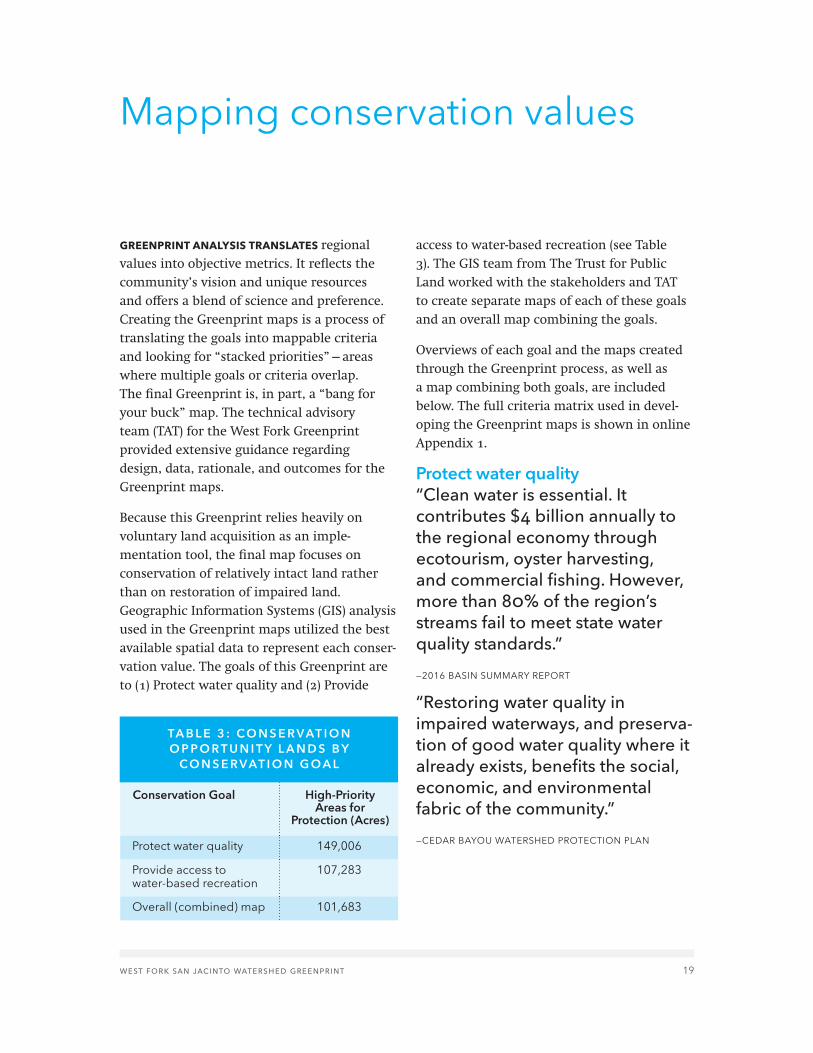
GREENPRINT ANALYSIS TRANSLATES regional values into objective metrics. It reflects the community’s vision and unique resources and offers a blend of science and preference. Creating the Greenprint maps is a process of translating the goals into mappable criteria and looking for “stacked priorities”—areas where multiple goals or criteria overlap. The final Greenprint is, in part, a “bang for your buck” map. The technical advisory team (TAT) for the West Fork Greenprint provided extensive guidance regarding design, data, rationale, and outcomes for the Greenprint maps.
Because this Greenprint relies heavily on voluntary land acquisition as an imple-mentation tool, the final map focuses on conservation of relatively intact land rather than on restoration of impaired land. Geographic Information Systems (GIS) analysis used in the Greenprint maps utilized the best available spatial data to represent each conser-vation value. The goals of this Greenprint are to (1) Protect water quality and (2) Provide
access to water-based recreation (see Table 3). The GIS team from The Trust for Public Land worked with the stakeholders and TAT to create separate maps of each of these goals and an overall map combining the goals.
Overviews of each goal and the maps created through the Greenprint process, as well as a map combining both goals, are included below. The full criteria matrix used in devel-oping the Greenprint maps is shown in online Appendix 1.
Protect water quality“Clean water is essential. It contributes $4 billion annually to the regional economy through ecotourism, oyster harvesting, and commercial fishing. However, more than 80% of the region’s streams fail to meet state water quality standards.”
—2016 BASIN SUMMARY REPORT
“Restoring water quality in impaired waterways, and preserva-tion of good water quality where it already exists, benefits the social, economic, and environmental fabric of the community.”
—CEDAR BAYOU WATERSHED PROTECTION PLAN
Mapping conservation values
Protect water quality 149,006
Provide access to water-based recreation
107,283
Overall (combined) map 101,683
TA B L E 3 : C O N S E R VAT I O N O P P O R T U N I T Y L A N D S B Y
C O N S E R VAT I O N G O A L
High-Priority Areas for
Protection (Acres)
Conservation Goal

20 west fork san jacinto watershed greenprint
figure 2 Special thanks to the following data provider: Bayou Land Conservancy Copyright © The Trust for Public Land. The Trust for Public Land and The Trust for Public Land logo are federally registered marks of The Trust for Public Land. Information on this map is provided for purposes of discussion and visualization only.
Little LakeCreek
Wilderness
Cook's BranchConservancy
Sam HoustonNational
Forest
Jones StateForest
La
ke
Co
nroe
L A K EC O N R O E
L A K EC R E E K
W E S T F O R KS A N J A C I N T O
R I V E R
HARRISCOUNTY
MONTGOMERYCOUNTY
WALLERCOUNTY
GRIMESCOUNTY
SAN JACINTOCOUNTY
WALKERCOUNTY
CONROE
HUNTSVILLE
PORTER
SPRING
THEWOODLANDS
L ak
e Creek
M i l l C re ek
Cyp re s s C re e k
Ca ney
Cr e
ek
C ampCr e ek
WestFor k
S a nJ a
c i n t o R i v e r
M ou ndCr e ek
M C RaeCr e
ek
Wes t S a n dy C r e e k
C a n e yC r e e k
E a st
For k
Cry
st a
lCre
ek
S o
u t h
Bedias
C r e e
k
Ea st S a
ndy C r e
e k
Bog
g yC re e k
Spr i
n gCre e
k
C a ne y C r ee k
Li t t l eC a n e y Cr e e k
Wes t
F o rkS
a n Jacin
toRiv
er
P e a c h Cr e e k
S
p r in gC r e e
k
S p r i ngCree
k
UV242
UV57
UV75
UV105
UV30
UV150
UV19
UV249
UV90
£¤190
£¤59
§̈¦45
Protect water qualityW E S T F O R K S A N J A C I N T O W A T E R S H E D G R E E N P R I N T
LakeConroe
LakeHouston
LakeLivingston
TrinityBay
GalvestonBay
THEWOODLANDS
HOUSTONPASADENA
Study area (by watershed)
Water Quality Protection PrioritiesHigh
Moderate to high
Moderate
County boundary
USFS administrative boundary
Wilderness Area
Parks, preserves, and open space
Conservation easement orprivate conservation land
This map was created using a weighted overlayanalysis based on the following water quality criteria:
Conserve areas that are at risk from sand and gravel operations(22%)
Conserve floodplains to prevent incompatible development (20%)Protect wetlands and riparian areas (20%)
Protect areas that are susceptible to erosion (3%)Preserve areas with natural and native vegetation along waterbodies
(3%)Protect areas that are vulnerable to high-impact development (3%)
Protect areas that are vulnerable to high-impact/unauthorizedrecreation (3%)
Protect steep stream banks (3%)Protect contiguous intact forest (15%)
Floodplains and buffers (3%)Protect Steep Slopes (5%)
0 2.5 5Miles ±
west fork san jacinto watershed greenprint 21
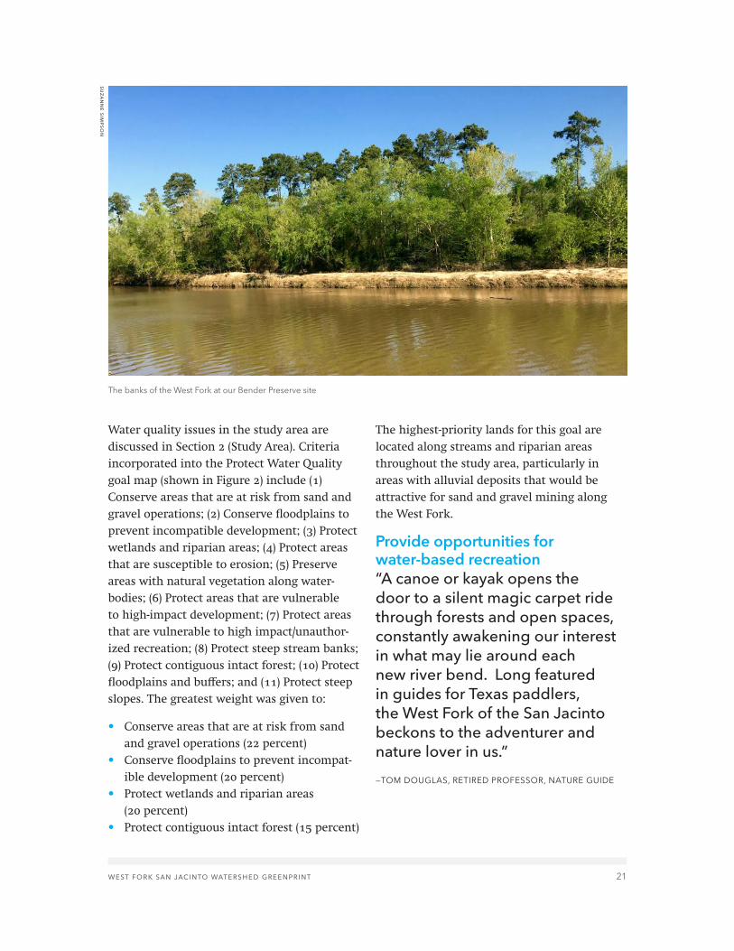
Water quality issues in the study area are discussed in Section 2 (Study Area). Criteria incorporated into the Protect Water Quality goal map (shown in Figure 2) include (1) Conserve areas that are at risk from sand and gravel operations; (2) Conserve floodplains to prevent incompatible development; (3) Protect wetlands and riparian areas; (4) Protect areas that are susceptible to erosion; (5) Preserve areas with natural vegetation along water-bodies; (6) Protect areas that are vulnerable to high-impact development; (7) Protect areas that are vulnerable to high impact/unauthor-ized recreation; (8) Protect steep stream banks; (9) Protect contiguous intact forest; (10) Protect floodplains and buffers; and (11) Protect steep slopes. The greatest weight was given to:
• Conserve areas that are at risk from sand and gravel operations (22 percent)
• Conserve floodplains to prevent incompat-ible development (20 percent)
• Protect wetlands and riparian areas (20 percent)
• Protect contiguous intact forest (15 percent)
The highest-priority lands for this goal are located along streams and riparian areas throughout the study area, particularly in areas with alluvial deposits that would be attractive for sand and gravel mining along the West Fork.
Provide opportunities for water-based recreation“A canoe or kayak opens the door to a silent magic carpet ride through forests and open spaces, constantly awakening our interest in what may lie around each new river bend. Long featured in guides for Texas paddlers, the West Fork of the San Jacinto beckons to the adventurer and nature lover in us.”
—TOM DOUGLAS, RETIRED PROFESSOR, NATURE GUIDE
The banks of the West Fork at our Bender Preserve site
suzan
ne sim
pson

22 west fork san jacinto watershed greenprint
figure 3 Special thanks to the following data provider: Bayou Land Conservancy Copyright © The Trust for Public Land. The Trust for Public Land and The Trust for Public Land logo are federally registered marks of The Trust for Public Land. Information on this map is provided for purposes of discussion and visualization only.
Little LakeCreek
Wilderness
Cook's BranchConservancy
Sam HoustonNational
Forest
Jones StateForest
La
ke
Co
nroe
L A K EC O N R O E
L A K EC R E E K
W E S T F O R KS A N J A C I N T O
R I V E R
HARRISCOUNTY
MONTGOMERYCOUNTY
WALLERCOUNTY
GRIMESCOUNTY
SAN JACINTOCOUNTY
WALKERCOUNTY
CONROE
HUNTSVILLE
PORTER
SPRING
THEWOODLANDS
L ak
e Creek
M i l l C re ek
Cyp re s s C re e k
Ca ney
Cr e
ek
C ampCr e ek
WestFor k
S a nJ a
c i n t o R i v e r
M ou ndCr e ek
M C RaeCr e
ek
Wes t S a n dy C r e e k
C a n e yC r e e k
E a st
For k
Cry
st a
lCre
ek
S o
u t h
Bedias
C r e e
k
Ea st S a
ndy C r e
e k
Bog
g yC re e k
Spr i
n gCre e
k
C a ne y C r ee k
Li t t l eC a n e y Cr e e k
Wes t
F o rkS
a n Jacin
toRiv
er
P e a c h Cr e e k
S
p r in gC r e e
k
S p r i ngCree
k
UV242
UV57
UV75
UV105
UV30
UV150
UV19
UV249
UV90
£¤190
£¤59
§̈¦45
Provide opportunities for water-based recreationW E S T F O R K S A N J A C I N T O W A T E R S H E D G R E E N P R I N T
LakeConroe
LakeHouston
LakeLivingston
TrinityBay
GalvestonBay
THEWOODLANDS
HOUSTONPASADENA
Study area (by watershed)
Water-Based Recreation PrioritiesHigh
Moderate to high
Moderate
County boundary
USFS administrative boundary
Wilderness Area
Parks, preserves, and open space
Conservation easement orprivate conservation land
This map was created using a weighted overlayanalysis based on the following water recreationcriteria:
Protect opportunities for birding (10%)Promote development of new water trails for canoeing, kayaking,
and tubing (10%)Promote opportunities for fishing (where water quality is good
enough) and for hunting (18%)Protect bottomland and hardwood habitat for recreation (12%)
Promote connectivity with protected areas (18%)Gaps in accessible lakeshore access (5%)
Park Equity (10%)Fishing access equity (12%)
Protect bottomland and hardwood habitat around parks (5%)
0 2.5 5Miles ±

west fork san jacinto watershed greenprint 23
Water-based recreation is important to local quality of life. Criteria incorporated into the Provide Access to Water-Based Recreation goal map (shown in Figure 3) include (1) Protect opportunities for birding; (2) Promote devel-opment of new water trails for canoeing, kayaking, and tubing; (3) Promote opportuni-ties for fishing (where water quality is good enough) and hunting; (4) Protect bottomland and hardwood habitat for recreation; (5) Promote connectivity with protected areas; (6) Fill gaps in lakeshore access; (7) Develop better park access equity; (8) Develop better fishing access equity; and (9) Protect bottomland and hardwood habitat around parks. The greatest weight was given to:
• Promote opportunities for fishing and hunting (18 percent)
• Promote connectivity with protected areas (18 percent)
• Protect bottomland and hardwood habitat for recreation (12 percent)
• Develop better fishing access equity (12 percent)
Potential access points for new water trails were field researched and digitized by TAT member Tom Douglas. The primary consid-eration for potential access points was that they should offer a launch site that is within a reasonable distance from a road, turnaround, or parking lot, which could potentially be accessed by a vehicle carrying canoes and/or kayaks. The nature of the access was also considered. For example, a sandbar is advan-tageous because it typically offers a gently
sloping beach from which launching boats is easy; sites on the inside of a river bend are preferred to a site on the outside of a river bend because the slope of the riverbank is more likely to be gentle on the inside of a bend.
The highest-priority lands for this goal are near major streams throughout the study area, especially those within two miles of a park and in areas with bottomland and hardwood habitat.
Overall Greenprint priorities mapFor the overall Greenprint priorities map, each goal was weighted according to the views of the stakeholders. Final weighting for the map was discussed and voted on at the October 2015 stakeholder meeting and reaffirmed at the final stakeholder meeting in March 2016. The resulting Overall Greenprint priorities map (shown in Figure 4) shows areas where the two Greenprint goals coincide, with particular emphasis on areas that are impor-tant for protecting water quality (weighted 75 percent). Because of the dominance of water as a community priority and because water-related criteria factored into both goals, the highest-priority lands for the map are along streams and along the shore of Lake Conroe.
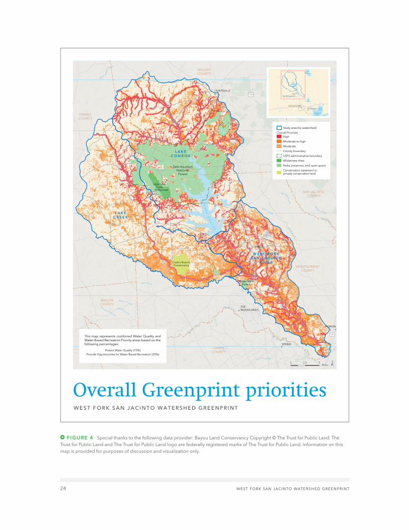
24 west fork san jacinto watershed greenprint
figure 4 Special thanks to the following data provider: Bayou Land Conservancy Copyright © The Trust for Public Land. The Trust for Public Land and The Trust for Public Land logo are federally registered marks of The Trust for Public Land. Information on this map is provided for purposes of discussion and visualization only.
Little LakeCreek
Wilderness
Cook's BranchConservancy
Sam HoustonNational
Forest
Jones StateForest
La
ke
Co
nroe
L A K EC O N R O E
L A K EC R E E K
W E S T F O R KS A N J A C I N T O
R I V E R
HARRISCOUNTY
MONTGOMERYCOUNTY
WALLERCOUNTY
GRIMESCOUNTY
SAN JACINTOCOUNTY
WALKERCOUNTY
CONROE
HUNTSVILLE
PORTER
SPRING
THEWOODLANDS
L ak
e Creek
M i l l C re ek
Cyp re s s C re e k
W a l n u t C r e e k
Ca ney
Cr e
ek
C ampCr e ek
WestFor k
S a nJ a
c i n t o R i v e r
M ou ndCr e ek
M C RaeCr e
ek
Wes t S a n dy C r e e k
C a n e yC r e e k
E a st
For k
Cry
st a
lCre
ek
S o
u t h
Bedias
C r e e
k
Ea st S a
ndy C r e
e k
Bog
g yC re e k
Spr i
n gCre e
k
C a ne y C r ee k
Li t t l eC a n e y Cr e e k
Wes t
F o rkS
a n Jacin
toRiv
er
B r ushy
C
r e e k
T h r e e m i l e C
r e e k
Pe ac h Cr e e k
S
p r in gC r e e
k
S p r i ngCree
k
UV242
UV57
UV75
UV105
UV30
UV150
UV19
UV249
UV90
£¤190
£¤59
§̈¦45
Overall Greenprint prioritiesW E S T F O R K S A N J A C I N T O W A T E R S H E D G R E E N P R I N T
LakeConroe
LakeHouston
LakeLivingston
TrinityBay
GalvestonBay
THEWOODLANDS
HOUSTONPASADENA
Study area (by watershed)
Overall PrioritiesHigh
Moderate to high
Moderate
County boundary
USFS administrative boundary
Wilderness Area
Parks, preserves, and open space
Conservation easement orprivate conservation land
This map represents combined Water Quality andWater-Based Recreation Priority areas based on thefollowing percentages:
Protect Water Quality (75%)Provide Opportunities for Water-Based Recreation (25%)
0 2.5 5Miles ±

west fork san jacinto watershed greenprint 25
IN DEVELOPING THE ACTION PLAN, stakeholders were asked, “What steps will be most impor-tant in ensuring that project objectives are met and the Greenprint is successfully implemented?” Stakeholders brainstormed and discussed action planning at meetings in October 2015 and March 2016. Action Plan items that received priority votes from stake-holders included targeting municipalities; promoting transparency in data and action; focusing on building partnerships; working with landowners as key partners; educating young people; creating funding through bond measures; and creating demonstration projects that provide training and hands-on experiences. The full action plan is shown in Table 4.
Integration with watershed protection planningThe Lake Conroe Watershed Protection Plan (WPP) was developed by the San Jacinto River Authority and covers the portion of the project area that drains directly into Lake Conroe. The outcome of this Greenprint process will help inform decisions made in implementing the Lake Conroe WPP. Another WPP effort is currently under way to address water quality challenges in the lower part of the project area comprising the Lake Creek and West Fork San Jacinto River watersheds. The information from this Greenprint project will inform stakeholder conversations and decisions related to local conservation priori-ties. WPPs often include recommendations for voluntary protections on riparian corridors and other conservation practices beneficial to water quality. By identifying local priori-ties and spatial locations of opportunities for conservation, this Greenprint will be used as a starting point for establishing WPP decisions about the location and scale of conservation recommendations.
Action plan
Cattle in Lake Creek Watershed
h-g
ac

26 west fork san jacinto watershed greenprint
A.1. Create a map of the high-priority areas for conservation that reflects the community’s wants/needs
The Trust for Public Land 2016
A.2. Work with local land trusts, local governments, and developers to prioritize land that most affects water quality
The Trust for Public Land, Bayou Land Conservancy and other land trusts
2016
A.3. Make GIS data/online tool available to partners so that it can be used in conservation planning; make sure data sources and planning are transparent; make sure that website is easy for partners to use
The Trust for Public Land 2016
A.4. Explore non-acquisition-based ways to protect priority lands; use Greenprint as a starting point to work with landowners/land managers on Best Management Practices; create ways to help landowners preserve ecosystem services of their properties
Natural Resources Conservation Service (NRCS), Soil and Water Conservation Districts (SWCDs), Bayou Land Conservancy, local governments, landowners
Ongoing, long term
B.1. Create an outreach plan for the Greenprint; create consistent messaging around conserving priority areas; address the problems that the community may face if we don’t protect these areas
The Trust for Public Land, H-GAC, local government agencies
2016
B.2. Identify key partners (especially landowners) and target them with strategic communications; make sure to stress respect for private property rights; ensure that the message is well delivered
H-GAC, The Trust for Public Land, Bayou Land Conservancy and other partners
2016, ongoing
TA B L E 4 : A C T I O N P L A N F O R T H E W E S T F O R K S A N J A C I N TO R I V E R W AT E R S H E D G R E E N P R I N T
Implementing Entities Implementation Timeline
Action Plan Idea
a. identify and conserve high-priority lands
b. develop an effective communications strategy

west fork san jacinto watershed greenprint 27
B.3. Host community meetings and showcase the benefits of having both recreation and land protection
The Trust for Public Land, stakeholder group
Ongoing
B.4. Create educational programs for youth; work with tech schools
Partners Ongoing
B.5. Reach out to counties, cities, municipal utility districts (MUDs), homeowner associations (HOAs), SWCDs, land trusts, and school districts about conservation planning
The Trust for Public Land, stakeholder group
Ongoing
B.6. Select, engage, and train champions for the Greenprint; identify organizations that have the resources to ensure success and can continue with public communications to accomplish implementation. Possibilities include:- Texas Master Naturalists- Houston Canoe Club- Churches with stewardship programs- Scouting groups- Business groups and visitors’ bureaus
Stakeholder group 2016, ongoing
B.7. Coordinate closely with other planning efforts, including Watershed Protection Plans
H-GAC, The Trust for Public Land, San Jacinto River Authority, stakeholder group
2016, ongoing
B.8. Create demonstration projects that provide training and encourage hands-on engagement
Partners Near future, as funding is available
B.9. Work to educate the public about the importance of protecting local waterways and recreational areas in order to discourage trash dumping
Partners 2016, ongoing
Implementing Entities Implementation Timeline
Action Plan Idea
b. develop an effective communications strategy
CONTINUED ON NEXT PAGE

28 west fork san jacinto watershed greenprint
Implementing Entities Implementation Timeline
Action Plan Idea
c. identify and pursue traditional and nontraditional funding sources to implement the Greenprint
d. monitor success of implementation
C.1. Identify funding sources for Greenprint implementation; generate interest in raising local bond funding for conservation
The Trust for Public Land and other partners
2016, ongoing
C.2. Identify incentives to help landowners with conservation
The Trust for Public Land, H-GAC, NRCS, SWCDs
2016, ongoing
C.3. Create a subcommittee to help acquire funding for the implementation
Stakeholder group 2016
D.1. Determine where the online interactive version of the Greenprint will be housed in the long term
The Trust for Public Land, local partners 2016
D.2. Create a mechanism through which the Greenprint can be updated
The Trust for Public Land, local partners 2016, ongoing
D.3. Ensure that information about data sources is thorough and easily available in order to facilitate updates
The Trust for Public Land 2016
D.4. Evaluate the Greenprint annually, including 12 months after implementation for 10 years
The Trust for Public Land 2017, ongoing
D.5. Collect water quality data in the watershed before and after implementation and check in every few years to see quality status
H-GAC 2016, ongoing
TA B L E 4 : A C T I O N P L A N F O R T H E W E S T F O R K S A N J A C I N TO R I V E R W AT E R S H E D G R E E N P R I N T
CONTINUED FROM PREVIOUS PAGE

west fork san jacinto watershed greenprint 29
THE TRUST FOR PUBLIC LAND often describes financing conservation as a “funding quilt.” A funding quilt is a diverse set of reliable, long-term funding sources that come together to achieve land conservation objectives. Every funding quilt is unique and evolves over time. While local funding is generally the founda-tion of any long-term land conservation efforts external funding (federal, state, private) can be an important source of support. Competition for external funding is often fierce, and these types of funding are generally less reliable
due to ever-changing state and federal budget circumstances.
The most successful conservation funding programs have substantial, long-term, dedi-cated source of local revenue. With a reliable source of funds, local governments can estab-lish meaningful conservation priorities that protect the most valuable resources and meet important goals and values. Local govern-ments with significant funds are much better positioned to secure and leverage funding from the federal government and attract
Funding opportunities
Boat dock on Lake Conroe
h-g
ac

30 west fork san jacinto watershed greenprint
other local and state government or private philanthropic partners. Although Texas ranks 49th nationally in per capita state spending for conservation, Texas voters have voiced strong support for parks and conservation by approving more than $3 billion in local bonds and sales taxes. The rate of approval for local ballot measures in Texas is 91 percent, compared to the nationwide approval rate of 75 percent.
Communities in Texas have traditionally been able to rely on a mix of funding due to the availability of state funding through the state recreation grants funded by the sporting goods tax allocation and local conservation funding measures. Our research suggests that potential local funding mechanisms include bonds, property taxes, sales tax, and impact fees. Each of these is described in more detail below. It is worth noting that since much of the threat to water quality comes from urbanization in southern Montgomery County, Walker and Grimes Counties may be less inclined to support public funding.
Online Appendix 4 (Conservation Finance Resource Options Report) provides a brief summary of numerous state and federal conservation programs that could potentially be leveraged to support projects within the West Fork San Jacinto Watershed.
bonds. Bonds are far and away the most utilized tool for parks and conservation purposes by local governments in Texas, accounting for 79 of 90 measures on the ballot since 1996. Bonds provide several advantages
over pay-as-you-go funding, including the opportunity to make significant land acquisi-tions in the near term, presumably before the price of land increases. However, this mecha-nism is not always appropriate or feasible (for example, typically bond proceeds may not be used for stewardship purposes).
• Montgomery County could issue a bond for parks and watershed protection purposes. A $50 million bond would cost the average household about $21 per year.
• Grimes County could also issue a bond for watershed conservation. A $7 million bond, for example, would cost the average household about $21 each year. The county currently has no outstanding general obli-gation bonds.
• Walker County also has capacity to issue a bond for parks and watershed protection purposes. A $7 million bond in Walker County would cost the average household about $23 each year. Walker County also has sufficient capacity to levy property taxes to pay the debt service on a bond.
property taxes. The property tax is the single largest revenue source for many local jurisdictions, and the proceeds may be expended for parks and open space. However, there is no authority by which a portion of the tax may be dedicated for this purpose, so expenditures are subject to the annual appropriations process. In addition, state law limits the tax that a local entity can levy for general fund, permanent improvement fund, road and bridge fund, and jury fund purposes

west fork san jacinto watershed greenprint 31
to 80 cents per $100 valuation. However, all three counties have ample capacity under this 80 cent cap. Elected officials in each of the three jurisdictions could impose a levy for the general fund, which could be appropriated to parks and conservation as part of the annual budget. For example, Montgomery County could impose a tax of $0.0079 per $100 and collect roughly $3.8 million annually at a cost of $20 per year to the average homeowner in the county. At the same price point, Grimes County and Walker County could generate roughly $539,600 and $489,700 annually, respectively.
sales taxes. Sales taxes are not an option in the study area. Counties are limited to a 0.5 percent sales tax; Grimes County and Walker County are currently at the maximum. Mont-gomery County does not have a sales tax; however, other taxing jurisdictions within the county are currently at the maximum rate of 8.25 percent, so a sales tax is not a viable option in Montgomery County.
impact fees. In Texas, impact fees for capital improvements must be related to water, wastewater, flood control, or roadways. As such, additional impact fee revenues may be accessed only for park or conservation acquisi-tions that are part of a project serving one of these purposes, such as a project in partner-ship with a municipal water department or the Woodlands Joint Powers Agency.
other funding sources. A variety of other state, local, and private grant funds may be applicable to these efforts and should be pursued in complement to established local funding sources. A primary goal for conserva-tion in the Houston region as a whole is the inclusion of conservation projects for consid-eration under RESTORE Act funding programs, as part of the BP oil spill settlement. Houston Wilderness and other groups have compiled a Regional Conservation Plan (RCP) that high-lights projects and priorities for the region, including this basin. Local partners should consider adding projects identified in this Greenprint to the RCP to be considered for future funding applications, or to consider applying directly for RESTORE Act grant funding cycles.
For more detail on funding opportunities, see online Appendix 4 (Conservation Finance Resource Options Report).

32 west fork san jacinto watershed greenprint
UNCHECKED GROWTH THREATENS WATER
QUALITY and quality of life in the region surrounding the West Fork of the San Jacinto River. This Greenprint is intended to help the communities in the study area plan for a future that balances development pressures with protection of important resources, partic-ularly water quality. It is also meant to foster a strong foundation for economic growth by setting priorities for preserving natural and recreational resources that improve local quality of life.
The Greenprint highlights areas for strategic voluntary conservation and for thoughtful recreation access. Implementation of the Greenprint should respect private property rights and recognize the critical importance of working lands in the study area and their stewardship by ranchers and farmers, most of whom are deeply committed to main-taining the unique environment and rural culture of the West Fork San Jacinto, Lake Creek, and Lake Conroe Watersheds. While public recreational access can provide impor-tant opportunities for physical activity and connecting to the outdoors, this access must be well planned and maintained and devel-oped through engagement with and respect for longtime landowners and others who may be impacted.
Conclusion
Horses in Lake Creek Watershed
and
rea tantillo

west fork san jacinto watershed greenprint 33
Participants
Brandt Manchen Houston Sierra Club
Brian Koch Texas State Soil and Water Conservation Board
Jack Cagle Harris County commissioner
Damien Carey Lake Houston Area Nature Club
David Parkhill San Jacinto River Authority
Deborah January-Bevers Houston Wilderness
Eric Leshinsky Asakura Robinson Company
Glenn Buckley Lake Creek Greenway Partnership
Glenn Laird Harris County Flood Control District
Jennifer Lorenz Bayou Land Conservancy
Jill Bouillon Greens Bayou Corridor Coalition
Jim Lester Houston Area Research Council
Kyle Shelton Rice University, Kinder Institute for Urban Research
Linda Shead Shead Conservation Solutions
Mickey Merritt State forester, Texas A&M
Jason Iken City of Houston, Public Works and Engineering
Richard Chapin City of Houston, Public Works and Engineering
Shannon Dunne City of Houston, Public Works and Engineering
Sarah Mitchell Cook’s Branch Conservancy
Shane Harrington Texas A&M Forest Service
Davies Mtundu San Jacinto River Authority
Ronda Trow San Jacinto River Authority
TA B L E 5 : I N T E R V I E W E E S
Name Organization
The following people were interviewed either in person or by phone.
CONTINUED ON NEXT PAGE
Horses in Lake Creek Watershed

34 west fork san jacinto watershed greenprint
Adam Delouche Johnson Development
Alice Best Texas Parks and Wildlife Department
Amy Morris The Trust for Public Land
Andrew Isbell Walker County
Anna Deichman Galveston Bay Foundation
Becky Zitterich Lake Creek Greenway Partnership
Ben Plunkett Texas Forest Service
Bob Stokes Galveston Bay Foundation
Bob Wise Lake Creek Greenway Partnership
Brandt Manchen Houston Sierra Club
Bret Raley San Jacinto River Authority, Lake Conroe Division
Brian Koch Texas State Soil and Water Conservation Board
Charlie Head Johnson Development
Damien Carey Lake Houston Area Nature Club
David Parkhill San Jacinto River Authority
TA B L E 6 : S TA K E H O L D E R M E E T I N G PA R T I C I PA N T S
Sixty-two people representing over 30 local groups attended at least one of the stakeholder meetings.
Bret Raley San Jacinto River Authority
Michelle Guidry San Jacinto River Authority
Melissa Lanclos San Jacinto River Authority
Steve Hupp Bayou Preservation Association
Yvonne Forest City of Houston, Public Works and Engineering
Name
Name
Organization
Organization
CONTINUED FROM PREVIOUS PAGE

west fork san jacinto watershed greenprint 35
Don Dean Office of Precinct 2 Commissioner
Elizabeth Love Houston Endowment
Eric Leshinsky Asakura Robinson Company (consultant for Johnson Development)
Floyd Nauls USDA/NRCS, Walker County
Frank Green Montgomery County (Environmental Health)
Fred Gifford The Trust for Public Land
Glenda Callaway Ekistics Corp
Glenn Buckley Lake Creek Greenway Partnership, 1488 Community Association
Glenn Laird Harris County Flood Control District
Harold Hutcheson Conroe Convention and Visitors Bureau
Iris Gonzalez Bayou Land Conservancy
Jennifer Lorenz Bayou Land Conservancy
John Ross Burditt Consultants LLC (senior resource consultant)
John Graziano Lovin' G Ranch LLC
Jon Henderson Walker County
Justin Bower H-GAC
Kim Laird Texas Commission on Environmental Quality
Krien VerBerkmoes Lake Creek Greenway Partnership
Kylah Dias Bayou Preservation Association
Lauren Harper Houston Wilderness
Lindsey Roche Houston Wilderness
Mark Webb Texas Parks & Wildlife Department
Melissa Lanclos San Jacinto River Authority
Michelle Guidry San Jacinto River Authority
Name Organization
CONTINUED ON NEXT PAGE

36 west fork san jacinto watershed greenprint
Mike Bleier Lake Conroe Association
Mike Lange The Trust for Public Land
Mike Riggens City of Conroe
Mozelle Carter Montgomery County NRCS
N. Davies Mtundu San Jacinto River Authority
Nate Le Breche Bayou Preservation Association
Preetal Shah Asakura Robinson Company
Rebekah Dye Asakura Robinson Company
Richard Chapin City of Houston, Public Works, Engineering Services
Ronda Trow San Jacinto River Authority
Ryan Lanclos Montgomery County
Shane Simpson San Jacinto River Authority
Shyla Liebscher Houston Parks Board
Stephanie Prosser Bayou Lands Conservancy
Steve Hupp Bayou Preservation Association
Steven Johnston H-GAC
Tom Douglas Galveston Bay Foundation
Tom Grayson Lake Creek Greenway Partnership
Tom Smith National Fish and Wildlife Federation
Warren Oja Sam Houston National Forest
Name Organization
TA B L E 6 : S TA K E H O L D E R M E E T I N G PA R T I C I PA N T S
CONTINUED FROM PREVIOUS PAGE

west fork san jacinto watershed greenprint 37
Alice Best Texas Parks and Wildlife Department
Becky Zitterich Lake Creek Greenway Partnership
Bob Wise Lake Creek Greenway Partnership
Frank Green Montgomery County Environmental Health
Glenn Buckley Lake Creek Greenway Partnership
Glenn Laird Harris County Flood Control District
Jennifer Lorenz Bayou Land Conservancy
Justin Bower H-GAC
Lindsey Roche Houston Wilderness
Melissa Lanclos San Jacinto River Authority
Richard Chapin City of Houston
Stephanie Prosser Bayou Land Conservancy
Steve Hupp Bayou Preservation Association
Steven Johnston H-GAC
Tom Douglas Galveston Bay Foundation
Will Merrell H-GAC
TA B L E 7 . T E C H N I C A L A D V I S O R Y T E A M PA R T I C I PA N T S
Name Organization

The Trust for Public Land
101 Montgomery St., Suite 900
San Francisco, CA 94104
415.495.4014
photos: front top, suzanne simpson;
front bottom, andrea tantillo;
back, justin bower
tpl.org


![2011 DVGBC Greenprint [#031 Special]](https://static.documents.pub/doc/80x56/568bda031a28ab2034a92ea0/2011-dvgbc-greenprint-031-special.jpg)


