44
West of Exeter Route Resilience Study Summer 2014 Photo: Colin J Marsden

West of Exeter Route Resilience StudySummer 2014
Photo: Colin J Marsden

Contents
1. Executive summary 03
2. Introduction 06
3. Remit 07
4. Background 09
5. Threats 11
6. Options 15
7. Financial and economic appraisal 29
8. Summary 34
9. Next steps 37
Appendices
A. Historical 39
B. Measures to strengthen the existing railway 42
Network Rail – West of Exeter Route Resilience Study 02Summer 2014

Network Rail – West of Exeter Route Resilience Study 03Summer 20141. Executive summary
a. The challenge
Diffi cult terrain inland between Exeter and Newton Abbot led Isambard Kingdom Brunel to adopt a coastal route for the South Devon Railway. The legacy is an iconic stretch of railway dependent upon a succession of vulnerable engineering structures located in an extremely challenging environment.
Since opening in 1846 the seawall has often been damaged by marine erosion and overtopping, the coastal track fl ooded, and the line obstructed by cliff collapses. Without an alternative route, damage to the railway results in suspension of passenger and freight train services to the South West peninsula.
Network Rail and its predecessors have invested in measures to protect the railway, which has been progressively strengthened. However the most recent event, in February 2014, resulted in an eight-week closure.
The total cost to the railway industry of the events in February is assessed as being in the range of £40 million to £45 million. Work is ongoing by the local authorities to quantify the net cost to the regional and local economy.
As a result of the disruption, Network Rail was asked by Government to report on options to maintain a resilient rail service to the South West peninsula.
Stakeholders from local government, the business community, the Environment Agency and train operators have been involved throughout the development of this report. We greatly welcome the input which they have provided.
Network Rail has a duty to maintain and enhance its current network. This study sets out to consider in transport economic terms whether, in addition to enhancing the Dawlish route, there would be value for money in establishing a new diversionary route capable of running current and foreseen services in the case of disruption on the main line.
b. The options
Valid options will be feasible to build and operate, safe to operate and maintain, resilient against environmental threats, and capable of accommodating all or most train services that are likely to run in
the future. A successful option must also off er value for money. The following options have been identifi ed:
• Option 1 - The base case of continuing the current maintenance regime on the existing route.
• Option 2 - Further strengthening the existing railway. An early estimated cost of between £398 million and £659 million would be spread over four Control Periods with a series of trigger and hold points to refl ect funding availability, spend profi le and achieved level of resilience.
• Option 3 (Alternative Route A)- The former London & South Western Railway route from Exeter to Plymouth via Okehamptonwould be reconstructed at an estimated cost of £875 million.
• Option 4 (Alternative Route B)- Constructing a modern double-track railway on the alignment of the former Teign Valley branch line from Exeter to Newton Abbot. This has an estimated cost of £470 million. There is doubt as to whether a resilient railway is practical on this route.
• Option 5 (Alternative Routes C1 to C5) - Five alternative direct routes would provide a new line between Exeter and Newton Abbot at an estimated cost between £1.49 billion and£3.10 billion.
In each case the estimated cost is an early assessment which has been uplifted by 66 per cent to provide a level of contingency consistent with our appraisal guidelines. New route options are shown in Figure 1.
Strengthening of the existing route (Option 2) is the subject of a separate Network Rail study, due to report in the fi rst part of 2015, and the cost fi gure quoted above is indicative only.
• Intermediate options will be identifi ed between the base caseand the maximum possible strengthening scope.
• Investment will be prioritised to address specifi c threats and to obtain best value for money.
• Holistic solutions implemented where appropriate to protect both the railway and its neighbours, with external funding sought where possible.

Network Rail – West of Exeter Route Resilience Study 04Summer 20141. Executive summary
Figure 1: Options 3, 4 and 5 (Alternative Routes A, B and C1 to C5)
© Crown copyright and database rights 2014 Ordnance Survey AL100017326 2014
Meldon
Lydford
Bridestowe
Brentor
Mary Tavy
WringworthyTavistock
Shillamill
Bere Alston
Bere Ferrers
Ernesettle
St Budeaux
Plymouth
Coleford
Yeoford
Crediton NewtonSt Cyres
Cowley Bridge
PerridgeTunnel
Bridford
Christow
Ide
Exeter
St Thomas
Alphington
Exminster
ChudleighChudleighKnighton
Heathfield
Leygreen
NewtonAbbot
DawlishWarren
BishopsteigntonWare Barton
Route A
Route B
Route C1
Route C3Route C2
Route C4
Route C5
Okehampton
0 2 4 6 81Miles
Key
Existing Line
Proposed New Railway
Network Rail – West of Exeter Route Resilience Study 05Summer 2014
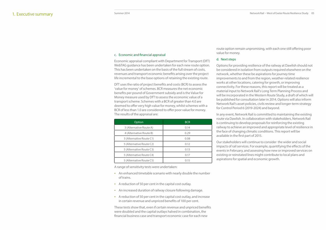
c. Economic and fi nancial appraisal
Economic appraisal compliant with Department for Transport (DfT) WebTAG guidance has been undertaken for each new route option. This has been undertaken on the basis of the full stream of costs, revenues and transport economic benefi ts arising over the project life incremental to the base options of retaining the existing route.
DfT uses the ratio of project benefi ts and costs (BCR) to assess the ‘value for money’ of schemes. BCR measures the net economic benefi ts per pound of Government subsidy and is the Value for Money measure used by DfT to assess the economic value of a transport scheme. Schemes with a BCR of greater than 4.0 are deemed to off er very high value for money, whilst schemes with a BCR of less than 1.0 are considered to off er poor value for money. The results of the appraisal are:
Option BCR
3 (Alternative Route A) 0.14
4 (Alternative Route B) 0.29
5 (Alternative Route C1) 0.08
5 (Alternative Route C2) 0.12
5 (Alternative Route C3) 0.13
5 (Alternative Route C4) 0.17
5 (Alternative Route C5) 0.15
A range of sensitivity tests were undertaken:
• An enhanced timetable scenario with nearly double the number of trains.
• A reduction of 50 per cent in the capital cost outlay.
• An increased duration of railway closure following damage.
• A reduction of 50 per cent in the capital cost outlay, and increase in certain revenue and unpriced benefi ts of 100 per cent.
These tests show that, even if certain revenue and unpriced benefi ts were doubled and the capital outlays halved in combination, the fi nancial business case and transport economic case for each new
route option remain unpromising, with each one still off ering poor value for money.
d. Next steps
Options for providing resilience of the railway at Dawlish should not be considered in isolation from outputs required elsewhere on the network, whether these be aspirations for journey time improvements to and from the region, weather-related resilience works at other locations, catering for growth, or improving connectivity. For these reasons, this report will be treated as a material input to Network Rail’s Long Term Planning Process and will be incorporated in the Western Route Study, a draft of which will be published for consultation later in 2014. Options will also inform Network Rail’s asset policies, civils review and longer-term strategy for Control Period 6 (2019-2024) and beyond.
In any event, Network Rail is committed to maintaining the existing route via Dawlish. In collaboration with stakeholders, Network Rail is continuing to develop proposals for reinforcing the existing railway to achieve an improved and appropriate level of resilience in the face of changing climatic conditions. This report will be available in the fi rst part of 2015.
Our stakeholders will continue to consider the wider and social impacts of rail services. For example, quantifying the eff ects of the events in February, and assessing how new or improved services on existing or reinstated lines might contribute to local plans and aspirations for spatial and economic growth.
1. Executive summary

Network Rail – West of Exeter Route Resilience Study 06Summer 20142. Introduction
The West of England main line through Exeter and Newton Abbot provides the only railway link between the South West peninsula and the rest of the country. Loss of the route, even temporarily, without a viable alternative has ramifi cations for the economy and for mobility and connectivity across the region.
The railway through Exeter and Newton Abbot carries direct long-distance train services between the South West peninsula and London, Bristol, Wales, the Midlands, Northern England and Scotland. The line also carries local trains and freight services.
In February 2014, exceptional weather caused the catastrophic destruction of a portion of the Dawlish sea wall and blockage of the line by landslides. Through rail services were suspended for eight weeks, with passengers carried on replacement bus and coach services. Freight traffi c was transferred to road or loaded at alternative locations.
The fi nal cost to the rail industry of this incident has been assessed at between £40 million and £45 million. This includes the cost of repairs to the infrastructure between Dawlish Warren and Teignmouth, and the compensation payable to passenger and freight train operators, and their customers.
The wider cost to the local economy resulting from the events at Dawlish is much harder to estimate for a number of reasons:
• It is diffi cult, if not impossible, to isolate the eff ects of line closure at Dawlish from other factors in play at the time. Train services to and from the South West peninsula were also seriously aff ectedby weather-related events elsewhere on the network. In addition, people may have been deterred from travelling simply because the weather was perceived to be bad, rather than specifi callybecause of the suspension of rail services.
• It is not known to what extent would-be rail travellers were ableto use other modes to undertake their journeys.
• There may be a delayed impact including loss of custom arising from longer-term reputational damage, the eff ects of which may not be known for some time.
• There is no established means of measuring the impact of such events, in terms of data-gathering or demonstrating a causal relationship.
• Some enterprises, such as local bus, coach and taxi fi rms, mayhave benefi ted from the situation.
Estimates of the economic cost have therefore varied signifi cantly. On average, some 12,500 rail journeys are made across this route each day. The question may be asked as to how much value is generated by each of those journeys, and to what extent that value is spent in the locality. This might at least provide an order-of-magnitude estimate of the possible economic loss to the region.
As a result of the events of February 2014, construction of a resilient railway route has been suggested as a means to safeguard train services to and from the South West peninsula. In collaboration with stakeholders Network Rail has commissioned a high level study to look at sustainable routes between Exeter and Plymouth. This study forms a part of Network Rail’s Long Term Planning Process, which proposes options for meeting demand across the rail network over a 30 year timescale.
Critical success factors for a sustainable route include technical feasibility, safe operation and maintenance, resilience against severe weather events, the ability to accommodate forecast demand, value for money and a journey time similar to (or better than) that of today.
This report summarises the fi ndings of Network Rail’s high level study. These fi ndings do not commit Network Rail to the construction of an additional route, nor should they be taken to indicate a preference for any particular alignment or solution.
The options put forward should be considered in totality with other long term outputs required from Network Rail’s Western Route, including improvements to reliability, connectivity, capacity, and journey time.
Network Rail – West of Exeter Route Resilience Study 07Summer 20143. Remit
The study has been remitted to investigate options for a sustainable railway route between the South West peninsula and the remainder of the UK.
a. Introduction
Following the breach of the railway at Dawlish in February 2014, Network Rail was asked by Government to report on options to maintain a resilient rail service to the South West peninsula in the event of similar weather events occurring again.
To produce the report, a study management group was established, comprising representatives from:
• Heart of the South West Local Enterprise Partnership
• Cornwall and Isles of Scilly Local Enterprise Partnership
• Cornwall Council
• Devon County Council
• Somerset County Council
• Plymouth City Council
• Torbay Council
• Department for Transport
• Environment Agency
• CrossCountry Trains
• First Great Western
• DB Schenker (representing all Freight Operating Companies)
• Network Rail.
We are grateful for the input and advice provided by our stakeholders in helping to prepare this document.
b. Requirements for a sustainable route
A sustainable route needs to address a range of critical success factors:
• Feasible - it is capable of being constructed to a realistic scheduleusing proven technologies.
• Technically compliant - it meets current standards for new railway infrastructure, including the ability to be electrifi ed in the future.
• Resilient - it avoids areas of known storm and fl ood risk. Where this is not possible, strengthening measures must mitigate the risk of damage.
• Capable - it is able ideally to accommodate all non-stop services and types of rolling stock, including freight, that currently traverse the coastal route between Exeter St. Davids and Newton Abbot, including forecast future growth.
• Safe - it supports safe construction, operation and maintenance.
• Effi cient - the whole life cost of new construction representsvalue for money to the funder and the railway industry.
• Fast - it off ers similar or improved journey times for all services that currently operate between Exeter and Plymouth.
We recognise the needs of the business community in the South West peninsula, the aspirations of passengers and freight customers, and the concerns of people living along the routes under consideration.
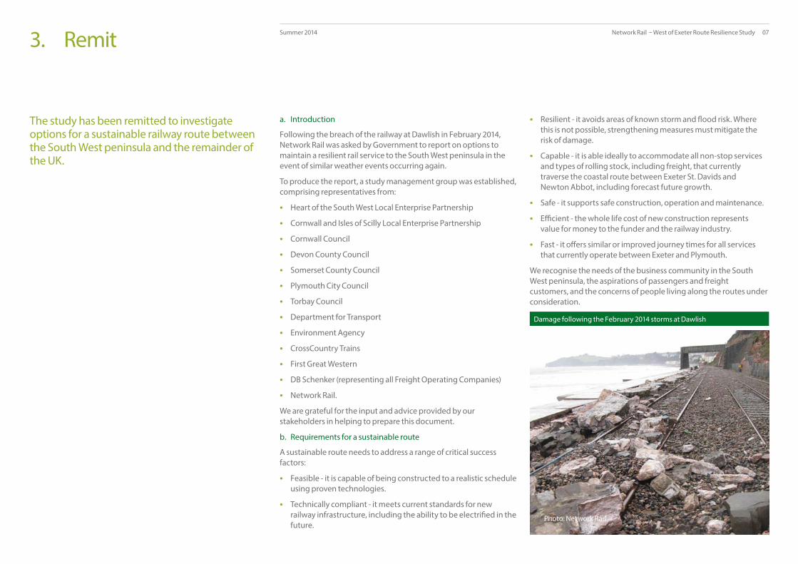
Photo: Network Rail
Damage following the February 2014 storms at Dawlish

Network Rail – West of Exeter Route Resilience Study 08Summer 20143. Remit
c. Options for further study
Option 1 - The Base Case of maintaining the existing railway• The current maintenance regime, including a reactive response
to incidents, would continue.
Option 2 - Further strengthening the existing railway
• The current route would be comprehensively strengthenedbetween Exeter and Newton Abbot through a series of interventions phased over approximately 20 years, greatly reducing vulnerability to geo-environmental and climactic threats.
• Further intermediate options exist between Option 1 and this Enhanced Base Option.
Option 3 (Alternative Route A) - London & South Western Railway (L&SWR) route• A modern double-track railway would be constructed on the
alignment of the former L&SWR route from Exeter to Plymouth. Existing tracks from Exeter to Meldon Quarry and from Plymouth to Bere Alston would be upgraded, and the line between Meldon Quarry and Bere Alston would be reinstated.
• Double-track and predominantly single-track sub-options exist.
Option 4 (Alternative Route B) - Great Western Railway (GWR) Teign Valley route• A modern double-track railway would be built on the alignment
of the former GWR branch line from Exeter to Newton Abbot. A new railway would be built along the former single-track alignment.
Option 5 (Alternative Routes C1 to C5) - Direct route• A completely new double track railway would be built inland,
bypassing vulnerable sections of the current route between Exeter and Newton Abbot. There are several potential routes.
Photo: First Great Western
First Great Western High Speed Train on the coastal railway near Dawlish

Network Rail – West of Exeter Route Resilience Study 09Summer 20144. Background
The West of England main line via Dawlish is currently the sole railway link between the South West peninsula and the remainder of the UK
a. The coastal railway
i. Engineering
The diffi cult inland terrain of the country between Exeter and Newton Abbot resulted in Isambard Kingdom Brunel’s adoption of a coastal route for the South Devon Railway. The coastal geomorphology is highly variable, encompassing the wide estuaries and open valleys of the Exe and Teign rivers and the steep sea cliff s, high headlands, small coves and narrow beaches of the coastal section between Dawlish Warren and Teignmouth.
In terms of engineering features and associated environmental and geo-environmental risks, the 32km of railway between Exeter and Newton Abbot can be divided in to fi ve principal segments:
Exeter to Dawlish WarrenExtensive Environment Agency fl ood defences are located seawards of the railway and run along the western margin of the Exe Estuary and Exe Canal to Powderham, from where the railway forms the seawall through Starcross to Dawlish Warren. The principal environmental risk along this section is estuarine and river fl ooding.
Dawlish Warren to Kennaway TunnelThe railway alignment runs on the Dawlish seawall between Dawlish Warren to Kennaway Tunnel. The line runs at the base of a high sandstone cliff line as far as the steep sided valley at Dawlish, from where it is backed by high cliff lines to Kennaway Tunnel. The principal environmental risks along this section are marine erosion and cliff instability.
Kennaway Tunnel to Parsons TunnelThe railway runs through several tunnels and over a masonry seawall situated at the base of high vertical sandstone cliff s. The principal environmental risks along this section are marine erosion and rockfall.
Parsons Tunnel to TeignmouthThe railway runs on the seawall situated at the base of a high cliff line formed from highly variable, soft bedrock. The principal environmental risks along this section are marine erosion, cliff failure and landslides.
Teignmouth to Newton AbbotThe railway runs along the River Teign wall situated on the east bank of the Teign Estuary. The principal environmental risk along this section is estuarine and river fl ooding.
ii. Capability
Speeds between 60mph and 80mph are permitted on the coastal railway between Starcross and Teignmouth. Faster speeds up to 100mph are permitted closer to Newton Abbot and Exeter.
The coastal railway accommodates a wide range of diesel-powered passenger and freight rolling stock, including High Speed Trains operated by First Great Western, Class 220 Voyagers used by CrossCountry and Class 66 freight locomotives. Occasional seasonal excursions are operated by heritage traction.
iii. Traffi c
• A total of 134 passenger trains are timetabled to run via Dawlish each weekday. On average two commercial freight trains use the route each weekday, but up to 14 daily freight timetable slots are provided to give fl exibility to operators and to enable engineering trains to operate across the route.
b. Journey opportunities
i. Population
The population of Devon and Cornwall has increased by 7.3 per cent since 1997 and a 20 per cent increase is forecast to 2026. This level of growth is above average for the UK as a whole.
ii. Connections
Dawlish is served by First Great Western local trains on an approximately hourly basis during the day, and a half hourly basis at peak times. Selected First Great Western trains from Bristol and London also call at Dawlish
Some CrossCountry services between the North of England and Paignton, Plymouth and Penzance also call at Dawlish.

Network Rail – West of Exeter Route Resilience Study 10Summer 2014
c. Demand for rail travel
i. Historic and forecast growth
In line with national demand for rail travel, the South West peninsula has seen strong growth. Passenger growth in Devon and Cornwall, 72 per cent and 87 per cent respectively between 2004 and 2013, has exceeded the UK average.
ii. Long term planning
Substantial growth is forecast in the longer term, continuing the strong growth trend observed in the decade to 2013.
• The Great Western Route Utilisation Strategy (RUS) predicts continued growth with peak rail passenger demand forecast togrow by 41 per cent between 2008 and 2019, equivalent to an annual growth rate of 3.2 per cent.
• Overall off -peak demand is predicted to grow by 37 per cent. However summer travel to the coastal resorts may grow more strongly.
• Network Rail’s Long Distance Market Study predicts growth of 97per cent to 2043 on the corridor through Dawlish.
• Forecasts from the Freight Market Study suggest that commercial freight traffi c volumes by 2043 will remain broadlyas they are today, i.e. one to two trains in each direction per day.
Spring 2014 passenger train service via Dawlish
Operator Routes served Trains per weekday
Calling at Dawlish
CrossCountry Penzance/Plymouth/Paignton – Birmingham/Manchester/Leeds/ Scotland
34 5
First Great Western long distance
Penzance/Plymouth/Paignton – London
35 6
First Great Western sleeper
Penzance/Plymouth – London
2 0
First Great Western local
Penzance/Plymouth/Paignton - Newton Abbot/ Exeter/Bristol/South Wales
57 52
Total 128 63
Photo: Colin J Marsden
4. Background
Spring 2014 freight trains running via Dawlish
Typical commodities Daily paths available Daily paths used
China clay products, timber, petroleum
14 2
A First Great Western High Speed Train on the Dawlish seawall

Network Rail – West of Exeter Route Resilience Study 11Summer 2014
Coastal erosion, cliff collapse and estuarine fl ooding threaten sections of the West of England main line between Exeter and Newton Abbot. Rising sea levels will exacerbate vulnerability.
a. Challenges
Major failures of the seawall of a similar magnitude to the events of February 2014 have occurred on a number of occasions, and these are summarised in Appendix A. Landslides and rock falls have remained a regular hazard since the opening of the railway.
The whole alignment between Exeter and Newton Abbot is highly sensitive to the impact of climate change, including sea level changes, storm events and intensifi ed precipitation. The very poor geotechnical characteristics of the high and unstable steep cliff line between Parsons Tunnel and Teignmouth presents a particular long term risk.
Areas of risk include:
• Marine erosion and storm overtopping
• Estuarine & river fl ooding
• Cliff instability.
Figure 2 summarises the threats to each section of railway between Exeter and Newton Abbot.
5. Threats
A landslide in 1872 was recorded in a contemporary oil painting
Image: Phil Marsh

Network Rail – West of Exeter Route Resilience Study 12
Newton Abbot
Exeter St Davids
Exminster
Dawlish Warren
Cowley Bridge Junction
Teignmouth
Parsons Tunnel
Kennaway Tunnel
0 1 2 3 40.5Miles
Summer 2014
b. Marine erosion and storm overtopping
High tides, large waves, storm surges and sea spray threaten the entire length of the coastal railway between Dawlish Warren and Teignmouth. A rising sea level will exacerbate these threats.
Train services along the Dawlish seawall can be suspended by wave overtopping or sea spray, whilst wave erosion - particularly during high tides with a strong wind from the south east - poses a risk to both the structural integrity of the masonry wall and to the level of the beaches upon which the seawall is founded.
Wave overtopping and sea spray aff ect sensitive electronic components of both trains and the signalling equipment, whilst damage to the track and ballast can result from the destructive power of overtopping waves.
A combination of these factors results in high impact events such as that during February 2014 when a combination of high tides, large waves, storm force south-easterly winds and heavy precipitation resulted in failure of the seawall near Dawlish and a major landslide at Woodlands Avenue.
c. Estuarine & river fl ooding
High tides and storm surges - particularly during spring tides with strong south easterly winds - along the Exe and Teign estuaries together with river fl ooding within the Exe and Culm catchments have potential to cause extensive fl ooding within the Exe estuary.
Intertidal marshes between Exeter, Exminster and Powderham suff er annual and extensive inundations. Environment Agency fl ood defences protect the railway, local highways and domestic properties in the area. The future strategy for fl ood defence management and improvement in this area has been defi ned within the Shoreline Management Plan.
Estuarine and river fl ooding risks to the railway in the Teign estuary are less than in the Exe Estuary. However signifi cant local risks exist where the railway crosses the River Teign fl oodplain adjacent to Newton Abbot Racecourse. In addition the line bordering the Teign estuary is constructed on weak alluvium including land reclaimed from the sea.
Figures 3 and 4 summarise river and estuarine fl ood risks.
Figure 2: Geo-environmental threats to the Exeter to Newton Abbot railway
KeyExisting Railway
Area at Risk of River Flooding
Area at Risk of Estuarine and River Flooding
Area at Risk of Marine Erosion and Rockfall
Area at Risk of Marine Erosion of Seawall andCliff Instability
Area at Risk of Marine Erosion of Seawall andCliff Failures and Landslides
5. Threats

Network Rail – West of Exeter Route Resilience Study 13Summer 2014
f. Adaptive actions
Vulnerability assessment for the Exeter to Newton Abbot railway alignment has identifi ed two adaption actions applicable to segments of the alignment:
• ‘No Regrets’ – engineering solutions increase resilience of the assets to current and future impacts. This applies to the seawall and cliff lines between Dawlish Warren and Teignmouth.
• ‘Managed Adaptive’ – a staged approach addressing uncertainties and future risks allowing assets to be progressively strengthened. This applies to the estuary and river fl ooddefences between Exeter and Dawlish Warren and between Teignmouth and Newton Abbot.
5. Threats
d. Cliff instability
Slope failures between Dawlish and Teignmouth are considered to pose the highest geo-environmental risk to the sustainability of the railway line between Exeter and Newton Abbot.
The sea cliff s above the railway alignment have a history of landslide failure. Construction of the railway halted the natural marine erosion processes at the base of the cliff s which, left undisturbed, would maintain slopes in equilibrium. As a result the cliff s have steepened, leaving them weakened and prone to failure. Historically, major failures have occurred.
Extensive remedial works were undertaken between Parson’s Tunnel and Teignmouth in the early years of the present century. Nevertheless major failures occurred in 2013 and 2014 due to elevated groundwater levels arising from heavy rainfall.
The area of vertical sandstone cliff s between Kennaway and Parson’s Tunnel is prone to rock falls rather than landslides. Planned works between 2014 and 2019 include nets and rock bolting.
e. Climate change
The geographic setting of the railway between Exeter and Newton Abbot makes the alignment particularly susceptible to future climate change events. Tidal heights, wind speeds and the incidence of major storms and tidal surges may signifi cantly alter the risk of disruption and the quantum of damage arising from events.
Network Rail’s Western Route Climate Change Adaption Framework is based on UKCP09 climate change projections for the region. The Framework proposes measures to sustain resilience of all Western Route lines. The events of February 2014 demonstrated two particular climatic vulnerabilities:
• Sea level rise is a particular threat to the railway between Exeterand Newton Abbot, with a median rise of approximately 0.8m forecast by 2100 as shown in Figure 5.
• Intensifi ed precipitation represents a more general threat to the railway network, with specifi c implications for the railway between Exeter and Newton Abbot including river fl ooding andcliff failure.
Photo: Network Rail
Unstable sandstone cliff s above the line near Dawlish

Network Rail – West of Exeter Route Resilience Study 14Summer 2014
Newton Abbot
Teignmouth
5. Threats
Figure 5: UKCP09 sea level rise predictions for the Dawlish area
Figure 3: Flood risk in the Exe estuary Figure 4: Flood risk in the Teign estuary
Dawlish Warren
Exminster
Cockwood Harbour
Exeter St Davids
Key
Existing Railway
Flood Zone 3 (Tidal and Fluvial)
Flood Zone 2 (Tidal and Fluvial)
Key
Existing Railway
Flood Zone 3 (Tidal and Fluvial)
Flood Zone 2 (Tidal and Fluvial)
0
0.2
0.4
0.6
0.8
1
1.2
1.4
1.6
1.8
2
2010 2020 2030 2040 2050 2060 2070 2080 2090 2100
Years
Metres
95th percentile
50th percentile
5th percentile

Network Rail – West of Exeter Route Resilience Study 15Summer 20146. Options
Several options have been identifi ed in addition to strengthening the existing route: reconstructing the L&SWR route via Okehampton, building a new railway on the alignment of the GWR Teign Valley route, and fi ve potential routes for a brand new railway avoiding the coastal section through Dawlish.
Option 4 (Alternative Route B) - GWR Teign Valley route• A modern double-track railway would follow the alignment of
the former GWR branch line from Exeter to Newton Abbot.
Option 5 (Alternative Routes C1 to C5) - Direct routes• C1 - Alphington to Ware Barton, the most direct route which is
mostly in tunnel.
• C2 - Exminster to Ware Barton - a western alignment of which two-thirds runs in tunnel.
• C3 - Exminster to Ware Barton - an easterly alignment that reduces the length of tunnelling
• C4 - Exminster to Bishopsteignton - a more easterly alignment which further reduces the length of new construction.
• C5 - Dawlish Warren to Bishopsteignton - the shortest length of new construction.
The options
Option 1 - The Base Case of maintaining the existing railway• The existing route via Dawlish will continue to be maintained as
per the current regime, with damage repaired as and when it occurs.
Option 2 - Further strengthening the existing railway• The existing route would be comprehensively reinforced through
a series of interventions phased over approximately 20 years.
Option 3 (Alternative Route A) - L&SWR route• A modern double-track railway would be constructed on the
alignment of the former L&SWR route from Exeter to Plymouth.
Photo: CrossCountry trains
A CrossCountry Class 220 Voyager passing Dawlish

Network Rail – West of Exeter Route Resilience Study 16Summer 20146. Options
Option 1 - The Base Case of maintaining the existing railway
Prior to the events of February 2014, typical expenditure has been £0.8m per annum on sea wall and cliff maintenance plus approximately £5m once every fi ve years to recover from an incident such as a cliff collapse.
Remedial works to date during 2014 have proven unusually expensive at an estimated cost of £24 million. The cost includes repair of the seawall, restoration of track and signalling, repairs to Dawlish station and cliff stabilisation.
In the current fi ve-year Control Period (CP5 2014-2019) Network Rail is implementing a number of schemes aimed at increasing the resilience of the railway to severe weather events:
• Sections of the Dawlish seawall are being strengthened adjoining the stretch rebuilt following the 2014 breach at an estimated cost of £8 million. Figure 7 shows a cross section of the reinforced seawall.
• A further £5 million is committed to be spent in Control Period 6 (2019-2024) on seawall maintenance, measures to protect against rock falls, and repairs to tunnel portals.
• Elsewhere, improvements will be made to the West of England Main Line and to the diversionary route via Yeovil. Figure 6 summarises Network Rail’s committed CP5 resilience works supporting the Western Route.
Hinksey
Cowley Bridge Athelney and Cogload Jn
ChippingSodbury
Hele & Bradninch
Flax Bourton
Patchway Up Tunnel
Exeter to Westbury Diversionary RouteStaffords Bridge
Whiteball Tunnel
Figure 6: Locations of committed resilience enhancement works on the Western Route at locations other than Dawlish

Network Rail – West of Exeter Route Resilience Study 17Summer 20146. Options
Figure 7: Cross section of strengthened Dawlish seawall
The Dawlish seawall protects residential properties
Installing concrete sections to reinforce the Dawlish seawall
Photo: Network Rail
PRECAST 'L' UNITS CONNECTED VIA SHEAR KEY JOINTS. UNITS TYPE 1 AND 2 TO SUIT LEVELS. SEE TABLE 1
SUITABLE FILL
PARAPET WALL TO BE REINSTATED TO TIE INTO EXISTING. INSITU REINFORCED
CONCRETE SLAB FIXED TO PRECAST UNIT
COPING PROFILE TO BE SIMILAR TO EXISTING.
ROCK BOLTS ANCHORED INTO UNDERLYING ROCK AT 1.1m CTRS ALONG LENGTH OF WALL.
EXISTING STONEWORK PLATFORM.
WAVE DEFLECTOR.
MASS CONC INFILL.
OUTLINE OF EXISTING SEA WALL EITHER SIDE OF BREACH
DOWN MAIN
INDICATIVE REINFORCEMENT IN STEM:NF - B32@150 AND B20@150FF - B20@150 IN BOTH DIRECTIONS
INDICATIVE REINFORCEMENT IN BASE:
T1 = B32@150, T2 = B20@150B1 = B20@150, B2 = B20@150
NOMINAL 250 THICK FIBRE REINFORCED CONCRETE LEVELING STRIP WITH NOMINAL REINFORCEMENT.
300x300 CHAMFER.
DIM
EN
SIO
N B
DIMENSION A
Photo: Network Rail

Network Rail – West of Exeter Route Resilience Study 18June 20146. Options
Option 2 - Further strengthening the existing railway
i. Opportunities for intervention
A comprehensive programme of works would reduce the potential for geo-environmental and climactic events to disrupt the railway, and would improve the ability of the infrastructure to recover from events.
Planning and delivery of a geo-environmental resilience programme between Exeter and Newton Abbot would be a major project of regional scale and impact.
To deliver sustainable, cost eff ective resilience, strategies need to address three principal geo-environmental hazards:
Marine erosion and storm overtoppingMeasures to reduce vulnerability may include:
• Strengthening the sea wall and raising its parapet between Dawlish and Teignmouth to improve resilience to high tides,large waves and sea spray.
• Installation of rock armour against the seawall for protection against high tides and large waves.
• Creation of an off shore rock armour berm parallel to the existingsea wall to reduce the energy impacts of high tides and large waves.
• Strengthening signalling and track infrastructure to protect against salt water damage.
Estuarine and river fl oodingMeasures to reduce vulnerability may include:
• Raising the railway embankment and constructing viaducts to improve fl oodwater fl ows.
• Raising the height of existing Environment Agency fl oodprotection infrastructure.
• Constructing water retention areas to retain or slow fl oodwater.
• Installation of fl ood relief culverts to improve land drainage.
• Strengthening signalling and track infrastructure to protect
against water damage.
Cliff InstabilityMeasures to reduce vulnerability may include:
• Soil nailing and rock bolting to strengthen high sea cliff s.
• Installation of netting to reduce the hazards from falling rocks and surface soil failures on high and steep cliff areas.
• Construction of retaining walls to contain high risk cliff s.
• Installation of slope drainage to improve the shear strength of cliff material susceptible to failure during high precipitation.
• Regrading of cliff and slope profi les to establish stable cliff profi les.
Proposals are detailed in Appendix B.
ii. Timescale
The high cost of the works, diffi cult site access and the requirement to maintain train services during the works necessitate delivery over approximately four fi ve-year Control Periods. Works would be prioritised on the basis of risk and impact.
High level design parameters for future sea level, storm surge and rainfall events are based on those defi ned within the Western Route Climate Change Strategy.
iii. Funding
A programme to increase the resilience of the existing railway between Exeter and Newton Abbot has been provisionally estimated between £398 million and £659 million, including 66 per cent contingency uplift. This equates to an additional annual expenditure of approximately £30 million over 20 years.
It must be stressed that the proposal covers four future Control Periods with a series of trigger and hold points to refl ect the funding availability, spend profi le and achieved level of resilience. Further work over the next eighteen months will deliver a greater understanding of scope, achievable resilience and likely cost.
These fi gures exclude expenditure on Environment Agency fl ood defences and Southwest Water infrastructure.
Option 2 would strengthen the existing railway from Exeter to Newton Abbot.

Network Rail – West of Exeter Route Resilience Study 19Summer 20146. Options
Option 3 would reconstruct the former London & South Western Railway route from Exeter to Plymouth via Okehampton.
Option 3 (Alternative Route A) - The former London & South Western Railway route
The reinstated railway would use the original alignment throughout. A double track railway would be provided for the whole length. Figure 8 summarises the route:
• The route leaves the West of England main line at Cowley Bridge Junction and follows the Barnstaple line to Yeoford. At Coleford Junction the route diverges westward to follow a privately-owned line via Okehampton to Meldon quarry.
• Meldon viaduct, an 165 metre long and 46 metre high listed structure located immediately south of Meldon quarry, is too badly deteriorated for re-use. A new structure would be required, adjacent to the existing viaduct.
• From Meldon Quarry to Bere Alston, the dismantled line would need to be replaced. Some structures have been removed and the trackbed has been sold. In some places the trackbed has been lost under agriculture and, in a number of places, built upon. West Devon Borough Council offi ces and an NHS clinic occupy a site adjoining Tavistock North station, with a housing development on the trackbed north of Tavistock viaduct. Long sections of the route have been developed as a cycleway.
• Devon County Council is developing a project to bring the fi ve miles from Bere Alston to Tavistock back into use as a single track railway. This section, together with the existing line from Bere Alston to St. Budeaux would be re-doubled.
Compared to a newly constructed railway, Alternative Route A would pose a number of issues for maintenance:
• The route will not meet current maintenance clearance standards. Some sections would only be maintainable outside traffi c hours.
• It is likely that a proportion of existing earthworks will be defi cient, having been constructed prior to a modern knowledge of soil mechanics, adding a measure of uncertainty. The section between Tavistock and Okehampton, which is largely constructed on rock, may represent less of a problem.
Crossing the north of Dartmoor, the route is steep in railway terms, with a predominant gradient of 1 in 75. However there are even steeper gradients on the current route west of Newton Abbot.
In order to be electrifi ed, the route would require further work to increase clearances at bridges over the railway.
At 53 minutes, the theoretical non-stop Exeter to Plymouth journey time for a Class 220 Voyager train is estimated to be only 4 minutes longer than via Dawlish (which has been modelled at a comparative 49 minutes). However reversals add at least a further 10 to 14 minutes to through journeys.
• The running time penalty is modest since some sections of line would have higher speed limits than the current route.
• The route departs from Exeter in a northerly direction, requiring trains from London Paddington and Bristol to reverse, requiring at least seven minutes at Exeter for a High Speed Train and at least fi ve minutes for a Class 220 Voyager, and potentially longer which would also impact on capacity within the station area.
Photo: Jacobs
The former L&SWR alignment north of Tavistock

Network Rail – West of Exeter Route Resilience Study 20Summer 20146. Options
Meldon
Lydford
Bridestowe
Brentor
Mary Tavy
WringworthyTavistock
Shillamill
Bere Alston
Bere Ferrers
Ernesettle
St Budeaux
Plymouth
Coleford
Yeoford
Crediton NewtonSt Cyres
Cowley Bridge
Exeter
St Thomas
Alphington
Exminster
Heathfield
Leygreen
NewtonAbbot
DawlishWarren
BishopsteigntonWare Barton
Route A
Okehampton
0 2 4 6 81Miles
Figure 8: Alignment of Option 3 (Alternative Route A)
Key
Existing Line
Proposed New Railway

Network Rail – West of Exeter Route Resilience Study 21Summer 2014
• The route approaches Plymouth from the west, requiring services for Cornwall to undertake a further reversal, requiring at least another seven minutes for a High Speed Train and at least another fi ve minutes for a Class 220 Voyager, and potentially longer.
• In the event that the line through Dawlish is temporarily closed, replacement bus services would be required between Exeter and Newton Abbot. Trains would continue to operate between Newton Abbot and Paignton/ Plymouth.
There are a number of possible templates for train services over the line.
• Because of the longer journey time, it is assumed that through trains would not routinely use the route. It is assumed that a regular local service would be operated, with through trains diverted when required.
• A small proportion of First Great Western and CrossCountry trains may be operated via Okehampton in order that drivers retain familiarity with the route, although other means exist for drivers to retain route knowledge.
The journey time for a local stopping service between Exeter and Plymouth has been assessed as approximately 75 minutes, with a journey time of 29 minutes between Exeter and Okehampton.
• This assumes a Class 165 train making intermediate calls at Crediton, Okehampton, Tavistock, Bere Alston, Bere Ferrers, St Budeaux Victoria Road, Keynham, Dockyard and Devonport.
The cost of Alternative Route A with double track throughout is estimated at £875 million, including a 66 per cent uplift for contingency.
• The estimated cost per mile of the works, without fl ood risk alleviation, is broadly comparable to those for the Borders Rail and Airdrie-Bathgate projects in Scotland. However a higher proportion of viaducts and bridges on Alternative Route A, including Meldon viaduct, will increase costs.
6. Options
Flood resilience represents a challenge with this option. The trackbed in the River Creedy valley will need to be raised, and a number of overbridges will require renewal. These works would require closure of the Barnstaple line for an extended period.
• Up to 13km of track may need to be raised by up to three metres on a combination of higher and wider embankments (5.2km) and replacement of embankments by low viaducts on the same horizontal alignment (7.8km).
• New viaducts would improve fl oodplain connectivity and compensate for the impact of embankment raising and widening.
• Raising the track level through areas of fl ood risk may cost up to £290 million in a worst case scenario, in addition to the £875m identifi ed for core works. This estimate is considered high, takes into account the greatest volume of additional works that might be required, and assumes relatively high unit rates.
Photo: Jacobs
Parts of the former L&SWR route have been converted to a cycleway

Network Rail – West of Exeter Route Resilience Study 22Summer 2014
A predominantly single track option would support a regular service stopping at intermediate stations between Exeter and Plymouth together with a limited number of through trains operated along the route to retain driver knowledge (although there are other means of retaining route knowledge).
• A predominantly single track option with suitably located dynamic loops would support the estimated journey times, but with a lower reliability in the event that services are delayed.
• In the event that the coastal railway is closed, some local trains between Exeter and Plymouth may be cancelled and their calls made by diverted through services, or by road services.
A ‘reduced scope’ version of this option could provide a single line, with dynamic passing loops where required by the timetable. This approach is being adopted by the Borders Rail project in Scotland (which is a local railway with no diversionary function). A saving of 20-25 per cent in construction cost may be obtained (i.e. reducing the total cost to approximately £655 million to £700 million including 66 per cent contingency uplift).
• To improve reliability, loops may be up to 5km long, allowing trains to pass at line speed. However the majority of the route would be single track.
• Signalling would be simplifi ed and the number of points may be less than for a double track railway.
• Some replacement bridges would only be single track rather than double track and there would be a reduced need for rockfall protection in cuttings.
• Access for maintenance would be improved through the addition of a walkway along the majority of the route, which would not be possible with double track on the old formation.
6. Options
Photo: Jacobs
Council offi ces on the former L&SWR goods yard at Tavistock
Photo: Jacobs
The former L&SWR route near Lydford

Network Rail – West of Exeter Route Resilience Study 23Summer 20146. Options
Option 4 would construct a new railway on the alignment of the former Great Western Railway Teign Valley route from Exeter to Newton Abbot.
Option 4 (Alternative Route B) - former Teign Valley Railway route
The route leaves the main line at City Basin Junction, south of Exeter St. Thomas station, and follows the alignment of the former GWR Teign Valley railway. The original line was single track and the route would have to be widened throughout to accommodate a double-track railway. Figure 9 summarises the route:
• The route would use the short freight branch through Marsh Barton industrial estate, which is all that remains of the northern end of the former railway. It then follows the course of the former railway over a supermarket car park on a viaduct and behind a new housing development at Alphington.
• The route would require signifi cant work to the A30 road, which is a major commuter route into Exeter. The former railway route has been lost under a road junction and a new alignment would be required. The former alignment can be regained at Ide, although the station site is now occupied by a small housing development.
• Beyond Ide, the line would follow the former alignment. However, Perridge tunnel has partially collapsed. As both Perridge and Culver tunnels would require enlarging for double track, it is likely to be more practical to provide a new 1.5km tunnel.
• The line would require reinstating across farmland where the formation has been removed. New sections of route would also be required where the alignment is now being used by a road at Trusham Quarry and between Chudleigh and Chudleigh Knighton. Other sections are occupied by housing, including Christow and Ashton stations.
Construction, including moving tunnelling machinery and removing spoil, would be diffi cult owing to limited road access.
All former structures would require renewing or rebuilding for a two
track railway. Former level crossings at locations including Lower Ashton and Teign Bridge would need to be replaced by overbridges.
This option follows, as closely as possible, the original Teign Valley Railway.
• This route off ers the lowest speeds of any option, with 45mph to 50mph being the predominant speed. A journey time penalty of seven minutes is estimated for Class 220 Voyager trains.
• Whilst there are short sections where the alignment would allow speeds in excess of 100mph, speed restrictions either side of these sections would prevent the theoretical maximum speed being achieved.
• Considerable lengths of the proposed route lie within a fl ood risk area and the route is considered to be at major risk of fl uvial fl ooding. Mitigating the impact of the new railway on fl ood water behaviour may not be possible due to the local topography.
• On this basis Option 4 (Alternative Route B) is considered not to be sustainable.
• As the route traverses a relatively sparsely populated area, it is unlikely that any intermediate stations could be justifi ed.
• It is unlikely to be attractive to train operators as the journey time will be longer than via Dawlish.
• A small proportion of trains may be operated via the route in order that drivers retain familiarity, although other means exist for drivers to retain route knowledge.
Option 4 (Alternative Route B) is estimated to cost approximately £470 million, including a 66 per cent uplift for contingency.

Network Rail – West of Exeter Route Resilience Study 246. Options Summer 2014
Figure 9: Alignment of Option 4 (Alternative Route B)
PerridgeTunnel
Bridford
Christow
Ide St Thomas
Alphington
Chudleigh
ChudleighKnighton
Heathfield
Leygreen
NewtonAbbot
Route B
0 1 2 3 40.5Miles
Key
Existing Line
Proposed New Railway

Network Rail – West of Exeter Route Resilience Study 25Summer 20146. Options
Alternative Routes C1 to C5 provide fi ve potential new routes between Exeter and Newton Abbot.
Introduction to Option 5 (Alternative Routes C1 to C5)
i. Parameters
A new route may be designed to modern standards, although the alignment would be constrained by connections to the West of England main line. High level parameters for a new route include:
• Junctions with the West of England main line would not imposespeed restrictions
• The new route would be designed for 125mph where possible, helping facilitate journey time reductions
• A maximum gradient of 1 in 150 to allow freight train operation
• Clearances to support later electrifi cation
• Compliance with Technical Standards for Interoperability (TSI), which are likely to include standards for tunnels, infrastructure and Persons with Reduced Mobility (PRM).
Estimates are broadly comparable to those for High Speed 2, taking into account a higher proportion of tunnelling proposed between Exeter and Newton Abbot.
ii. Route options (see Figure 10)
There are fi ve locations where a new line potentially could diverge from the existing railway between Exeter and Starcross:
• Alphington (north of the A379 road)
• Exminster (either north or south of the former station)
• Powderham (south of the River Kenn)
• Between Starcross and Cockwood
• Between Eastdon and Dawlish Warren
There are three locations where a new line potentially could re-join the existing railway between Teignmouth and Newton Abbot:
• Bishopsteignton
• East of Newton Abbot, close to Ware Barton
• At Newton Abbot, joining the Heathfi eld line near Teigngrace.
Initial assessment against the high level parameters identifi ed twenty possible alignments. These were refi ned down to fi ve practical options, which are summarised in Figure 10.
The fi ve route options capture all reasonable alignments capable of a 125mph design speed and a maximum gradient of 1:150.
All routes will mostly traverse open country at the north end and in tunnel at the south end. Short tunnels are required near the north end of some routes.
iii. Tunnelling
Modern railway tunnels are designed to use precast concrete segmental linings where a Tunnel Boring Machine (TBM) is used. TBMs off er rapid excavation and lining of long tunnels in a range of ground conditions. Sprayed concrete linings would be used for the shorter, arch profi led, double track tunnels and cross passages.
For Alternative Routes C1 & C2, which include longer tunnels, it is assumed that four TBMs would be required to reduce the construction programme. This would require a TBM launch site at the north end of the route, which is more diffi cult to access. For the shorter twin bore tunnels two TBMs would be employed, launched from the south end of the route.
Tunnel headshafts would be sited close to local roads. In many cases these are minor roads which are expected to require upgrading for construction and emergency services access. The shafts would incorporate a staircase and lift for use by the emergency services and maintenance personnel. Direct access to both running tunnels would be provided at the shaft base through fi re protected doors.
Depending on the chosen alignment, tunnelling works could generate in excess of 2.5 million cubic metres of spoil. A waste management plan would be developed to provide an acceptable methodology for removing and disposing of spoil, with conveyor belts, rail and sea transport as options. Dawlish sandstone has been quarried locally for building sand and some of this tunnel spoil could be used in concrete production. The hard volcanic rocks and limestone may also be a useful source of coarse aggregates. It may also be possible to use some of the tunnel spoil in the construction of new railway embankments.

Network Rail – West of Exeter Route Resilience Study 26Summer 20146. Options
Figure 10: Alignment of Options 5 (Alternative Routes C1 to C5)
St Thomas
Alphington
Exminster
NewtonAbbot
DawlishWarren
Bishopsteignton
Ware Barton
Route C1
Route C3
Route C2
Route C4
Route C5
0 1 2 3 40.5Miles
S
Key
Existing Line
Proposed New Railway

Network Rail – West of Exeter Route Resilience Study 27Summer 20146. Options
Summary of Option 5 routes
Alternative Route C1 - new route between Alphington and Ware Barton This route leaves the West of England main line immediately south of the built-up area of Marsh Barton Trading Estate. It crosses an area of fl ood plain, then crosses under the A379 road (which will be raised) before entering a tunnel to bypass Exminster village. There are two more short tunnels separated by bridges over local watercourses before the line crosses the River Kenn near Pennycombe Farm. The line then runs in tunnel to Ware Barton on the Teign estuary, where it rejoins the West of England main line.
This option is estimated to cost approximately £3.10 billion, including 66 per cent uplift.
The through journey time is reduced by approximately 5 minutes.
Alternative Route C2 - new route between Exminster and Ware Barton This route leaves the West of England main line north of the former Exminster station, passing under Station Road and through the former station site, crossing the fl ood plain west of the railway on a low viaduct and turning south-west to climb. It passes under Powderham ridge in a short tunnel before crossing the Kenn valley on embankment and bridges. It continues running south-westerly on surface and in cutting before entering tunnel. It then runs in tunnel all the way to Ware Barton on the Teign estuary, where it rejoins the West of England main line.
This option is estimated to cost approximately £2.51 billion, including 66 per cent uplift.
The through journey time is reduced by approximately 6 minutes.
Alternative Route C3 - new route between Exminster and Ware Barton This route leaves the West of England main line at the former Exminster station and crosses the fl ood plain west of the main line on a low viaduct. It passes under Powderham ridge in a short tunnel before crossing the Kenn valley on an embankment and bridges. It passes to the west of Kenton, mainly in cutting, with a short tunnel south west of the village. After the tunnel the line turns south west, before entering the main tunnel. It then runs in tunnel to Ware
Barton on the Teign estuary, where it rejoins the West of England main line.
This option is estimated to cost approximately £2.25 billion, including 66 per cent uplift.
The through journey time is reduced by approximately 6 minutes.
Alternative Route C4 - new route between Exminster and Bishopsteignton This route starts by following the same alignment as Alternative Route C3. It leaves the West of England main line at the former Exminster station and crosses the fl ood plain west of the main line on a low viaduct. It passes under Powderham ridge in a short tunnel before crossing the Kenn valley on an embankment and bridges. It passes to the west of Kenton, mainly in cutting, with a short tunnel south west of the village. There the line diverges from the route of C3, continuing in a southerly direction before entering a tunnel under the ridge on the eastern side of Dawlish Water. It runs in tunnel to the north of Teignmouth and east of Bishopsteignton before passing under the A381 road and joining the West of England main line south of Bishopsteignton.
This option is estimated to cost approximately £1.56 billion, including 66 per cent uplift.
The through journey time is reduced by approximately 5 minutes.
Alternative Route C5 - new route between Dawlish Warren and Bishopsteignton This route leaves the West of England main line south of Eastdon crossing the coast road and turning south-west and then west to avoid the holiday camp areas east of the road. It passes north of Shutterton bridge, crossing the A379 road and then turns south-west again to follow the stream until entering a tunnel north-east of Langdon Road. The route then runs in tunnel to join the alignment of C4 to the north of Teignmouth and east of Bishopsteignton before passing under the A381 road and re-joining the West of England mail line south of Bishopsteignton.
This option is estimated to cost approximately £1.49 billion, including 66 per cent uplift.
The through journey time is reduced by approximately 3 minutes.

Network Rail – West of Exeter Route Resilience Study 28Summer 20146. Options
Table 1 summarises key parameters of the nine scenarios.
Estimates for Options 3, 4 and 5 are based on 2nd Quarter 2014 prices. Quantities are based on estimated distances, areas and volumes. Network Rail management costs are applied in accordance with guidelines.
The following items are excluded:
• Escalation costs
• Possession management costs
• Train operator and other compensation costs
• Utility diversions
• Legal costs
• Fees and charges for consents and approvals by third parties
• Cost of road closures
• Costs of dealing with contaminated land and ground water
• Modifi cations to Exeter signal box
• VAT
• Public enquiry and consultation costs
• Archaeological costs
Table 1: Summary of route option parameters
Option Usage of the resilient railway route Length of new line (km)
of whichTotal Tunnel
Change to Exeter-Plymouth distance (km)
Change to non-stop Exeter-Plymouth journey time Exeter (Class 220, minutes)
Length of vulnerable route remaining between Exeter and Plymouth (km)
Estimated cost at 2014 cost base including contingency (£m)
Option 1 - Base Case of maintaining existing railway
Existing railway used by all trains Nil Nil Nil Nil 32.0 0.8 per annum +5 every fi ve years
Option 2 - Further strengthening existing railway
Existing railway used by all trains Nil Nil Nil Nil Nil 398 - 659
Option 3 (Alternative Route A) - L&SWR route
New route used by new local service and diverted long distance trains 33.1 0.6 +2.6 +4 (adds 14 to 20 to through journey time)
13.0 875
Option 4 (Alternative Route B) - Teign valley route
New route used by diverted local and long distance trains 24.1 1.1 +0.7 +7 14.7 470
Option 5 (Alternative Route C1) - Alphington to Ware Barton
New route used by all non-stop trains between Exeter and Newton Abbot 18.8 15.8 -7.6 -5 3.4 3,100
Option 5 (Alternative Route C2) - Exminster to Ware Barton (western)
New route used by all non-stop trains between Exeter and Newton Abbot 17.3 11.4 -6.4 -6 7.3 2,510
Option 5 (Alternative Route C3) -Exminster to Ware Barton (eastern)
New route used by all non-stop trains between Exeter and Newton Abbot 17.1 9.9 -5.9 -6 7.5 2,250
Option 5 (Alternative Route C4) - Exminster to Bishopsteignton
New route used by all non-stop trains between Exeter and Newton Abbot 15.8 6.5 -3.9 -5 8.1 1,560
Option 5 (Alternative Route C5) -Dawlish Warren to Bishopsteignton
New route used by all non-stop trains between Exeter and Newton Abbot 9.9 6.3 -1.6 -3 14.7 1,490

Network Rail – West of Exeter Route Resilience Study 29Summer 20147. Financial andeconomic appraisal
Financial appraisal of the alternative route options, consistent with DfT guidance, demonstrates that each represents poor value for money, even under more favourable sensitivity tests.
a. Remit
Appraisal work was commissioned by Network Rail to assess the outline business case for each of the seven potential diversionary routes described in the previous section.
The scope of this appraisal activity can be summarised as follows:
• To establish a base case, the existing railway via Dawlish would remain the only rail route between Plymouth and Exeter as now. This base case also includes review of the extent to which the Dawlish route could be expected not to be available for traffi cdue to planned engineering possessions and unplanned disruption, and the road replacement services to be assumed
• To identify the scale of disruption compensation costs for the base case, which potentially could be avoided were an alternative/diversionary route to be available
• To devise appropriate train service specifi cations for each route option, taking advantage of the new route:
– For planned train services only where it off ers journey time savings compared with the existing route via Dawlish
– For diversions on those occasions when the route via Dawlish is not available for traffi c
• To assess the likely scale of passenger demand and revenue impacts for each option
• To assess the annual operating costs for each option
• To prepare an outline UK rail fi nancial business case appraisal and DfT WebTAG compliant transport economic appraisal, including unpriced user and non-user benefi ts. The appraisal compares the seven alternative/diversionary route options against the base case
• To test the extent to which stakeholders’ aspirational higher train service level scenario would change the appraisal results, together with appropriate sensitivity testing to illustrate the robustness of the results and conclusions.
In all the options, the route via Dawlish is retained with existing calls at the intermediate stations maintained. It is assumed that in the short to medium term works will have been undertaken to the route to ensure comparable standards of resilience to levels of risk similar to the average over the last 40 years.
b. General assumptions
The appraisal assumes that capital outlay expenditure for the construction of each new route option would commence in 2021 and be completed by 2026, with operation from 2027. Present Values for the costs and benefi ts are calculated over a 60 year appraisal period, allowing calculation of the Net Present Value (NPV) of the option (i.e. the net economic benefi ts generated by the option compared with the do-minimum base case) and the Benefi t to Cost Ratio (BCR).
The key parameters assumed in the economic appraisal of the new routes are consistent with the guidance set out in WebTAG, especially unit 3.13.1 ‘Guidance on Rail Appraisal’ and unit 3.5.6 ‘Values of Time and Vehicle Operating Costs’:
• The appraisal is undertaken in real terms at 2014 constant price levels
• Demand growth is capped after 20 years (i.e. from 2034)
• Economic benefi ts grow in line with GDP per capita (with anelasticity of 0.8 for non-work trips)
• Discounted by 3.5 per cent for the fi rst 30 years and 3 per cent for the following 30 years.
Transport economic benefi ts as included in WebTAG appraisal stem from journey time savings to existing and new users, with standard WebTAG values of time.
Benefi ts to non-rail users through modal shift from car to rail (e.g. road decongestion, environmental benefi ts) have been included in the appraisal, using DfT WebTAG valuations of monetary benefi ts per passenger km for the South West of England.
Indirect taxation impacts are also factored into the appraisal. This is the eff ect on tax revenues of users switching from private car and therefore contributing less in fuel duty.

Network Rail – West of Exeter Route Resilience Study 30Summer 20147. Financial & economic appraisal
The capital costs quoted for each option include a 66 per cent uplift for risk/contingency, and have therefore been treated as having already been adjusted for optimism bias.
For each option, an assessment was also made of:
• Operation and maintenance costs for the new routes
• Reductions (or increases) in journey times, and the consequent demand and revenue eff ects
• Increases or decreases in train mileage and associated costs
• Compensation costs to operators avoided by having a diversionary route
• The demand and revenue eff ects of diverted rail journeysinstead of road replacement.
c. Results
i. Option 3 (Alternative Route A) - reinstated railway via Tavistock and Okehampton
As a potential source of benefi t arising from this route option, the introduction of a regular hourly planned train service operating between Plymouth and Exeter, calling all stations to Bere Alston, Tavistock, Sourton Parkway, Okehampton, Crediton and Exeter St. Davids has been assessed. The assessment and appraisal of such a service based upon current demographics and assumed trip rates has found that the transport economic benefi ts would fail to cover the marginal costs of train operation, with a BCR (over a 60-year period) of 0.82. Table 2 summarises the fi ndings.
Therefore appraisal of this option as a diversionary route omits such a local service as it would signifi cantly worsen the performance of the option in the appraisal.
Table 2Alternative Route A - reinstated railway via Tavistock and Okehampton
Benefi ts and costs compared to base case, 2014 prices (£m)
UK Rail revenue impact 28
User time savings 134
Road decongestion 2
Infrastructure 0
Accident 1
Local air quality 0
Noise 0
Greenhouse gases 0
Indirect taxation -3
Unpriced user and non-user benefi ts 135
Operating costs 162
Capital costs 814
NPV -813
BCR 0.14

Network Rail – West of Exeter Route Resilience Study 31Summer 2014
ii. Option 4 (Alternative Route B): new railway via the Teign Valley alignment
The performance of Alternative Route B as a diversionary route has been assessed against the base case. Table 3 summarises the fi ndings.
Table 3Alternative Route B - new railway via the Teign Valley alignment
Benefi ts and costs compared to base case, 2014 prices (£m)
UK Rail revenue impact 30
User time savings 138
Road decongestion 3
Infrastructure 0
Accident 1
Local air quality 0
Noise 0
Greenhouse gases 1
Indirect taxation -3
Unpriced user and non-user benefi ts 139
Operating costs 79
Capital costs 436
NPV -346
BCR 0.29
iii. Option 5 (Alternative Routes C1-C5): new inland railway alignments between Exeter and Newton Abbot
The performance of C1 to C5 as alternative routes has been assessed against the base case. Table 4 summarises the fi ndings.
Table 4
Alternative Routes C1 to C5 - new inland railway alignments between Exeter and Newton Abbot
Benefi ts and costs compared to base case, 2014 prices (£m)
C1 C2 C3 C4 C5
UK Rail revenue impact 66 74 74 66 56
User time savings 235 265 265 234 203
Road decongestion 6 6 6 6 5
Infrastructure 0 0 0 0 0
Accident 2 2 2 2 1
Local air quality 0 0 0 0 0
Noise 0 0 0 0 0
Greenhouse gases 1 1 1 1 1
Indirect taxation -7 -8 -8 -7 -6
Unpriced user and non-user benefi ts
238 267 267 236 205
Operating costs -7 -2 1 12 9
Capital costs 2,883 2,338 2,096 1,448 1,387
NPV -2,572 -1,995 -1,755 -1,157 -1,134
BCR 0.08 0.12 0.13 0.17 0.15
It should be noted that the capital costs shown in the appraisal results for the alternative routes above diff er slightly from the fi gures given in Section 6. This is because the capital costs in the table above represent the present values of cashfl ows resulting from the phasing of capital expenditure over an assumed six year construction period, funded through the Network Rail Regulatory Asset Base (RAB).
7. Financial & economic appraisal

Network Rail – West of Exeter Route Resilience Study 32Summer 2014
d. Sensitivity tests
Four sensitivity tests were conducted in order to understand the impact of changes in the underlying assumptions. Table 5 refers.
i. Enhanced timetable test
An enhanced timetable scenario was derived from aspirations expressed by stakeholders for an increase in frequencies, mainly along the coastal route. Table 5 refers.
ii. Reduced capital cost test
The eff ect of a substantial reduction of 50 per cent in the capital cost of each option was tested. Table 6 refers.
iii. Longer closure of the coastal route test
The eff ect of assuming a longer than average duration of closure of the existing route - an annual 10 per cent chance of the route being shut for 40 days - was tested. The central case assumed an annual 10 per cent chance of the route being shut for 15 days. Table 7 refers.
iv. Optimistic revenue and capital cost test
Revenue and unpriced benefi ts attributable to the operation of the option timetable (compared to the existing situation) were doubled, and the capital costs for the additional route options halved. In this test, no change was made to the contribution to revenue relating to performance regime savings, nor the associated user and non-user benefi ts. Note that in the cases of Alternative Routes A and B, the option timetable contributes a negative benefi t compared to the existing situation, which is also doubled in the sensitivity test, leading to a reduction in total benefi ts compared with the central case. Table 8 refers.
7. Financial & economic appraisal
Table 5: Enhanced timetable test Benefi ts and costs compared to base case, 2014 prices (£m)
A B C1 C2 C3 C4 C5
UK Rail revenue impact 29 32 70 79 79 70 60
User time savings 142 146 250 281 281 249 216
Road decongestion 3 3 6 7 7 6 5
Infrastructure 0 0 0 0 0 0 0
Accident 1 1 2 2 2 2 2
Local air quality 0 0 0 0 0 0 0
Noise 0 0 0 0 0 0 0
Greenhouse gases 1 1 1 1 1 1 1
Indirect taxation -3 -3 -7 -8 -8 -7 -6
Unpriced user and non-user benefi ts 143 147 252 284 284 251 218
Operating costs 162 79 -56 -41 -38 -16 -2
Capital costs 814 436 2,883 2,338 2,096 1,448 1,387
NPV -804 -336 -2,505 -1,934 -1,696 -1,111 -1,107
BCR 0.15 0.30 0.09 0.13 0.14 0.18 0.16
Table 6: Reduced capital cost test Benefi ts and costs compared to base case, 2014 prices (£m)
A B C1 C2 C3 C4 C5
UK Rail revenue impact 28 30 66 74 74 66 56
User time savings 134 138 235 265 265 234 203
Road decongestion 2 3 6 6 6 6 5
Infrastructure 0 0 0 0 0 0 0
Accident 1 1 2 2 2 2 1
Local air quality 0 0 0 0 0 0 0
Noise 0 0 0 0 0 0 0
Greenhouse gases 0 1 1 1 1 1 1
Indirect taxation -3 -3 -7 -8 -8 -7 -6
Unpriced user and non-user benefi ts 135 139 238 267 267 236 205
Operating costs 162 79 -7 -2 1 12 9
Capital costs 407 218 1,441 1,169 1,048 724 693
NPV -406 -128 -1,131 -826 -707 -433 -440
BCR 0.25 0.52 0.17 0.24 0.27 0.35 0.32

Network Rail – West of Exeter Route Resilience Study 33Summer 2014
e. Conclusions
The results indicate that, from a transport economic appraisal point of view, all the alternative route options represent poor value for money. This remains true under a range of sensitivity tests.
Apart from those listed above, this appraisal has not taken account of wider social and economic benefi ts that might have been forgone during the closure of the railway in February 2014. Our stakeholders continue to gather research to help quantify the size of these wider impacts, and to understand the extent to which they might contribute towards enhancing any business case for an additional or alternative route.
7. Financial & economic appraisal
Table 7: Longer closure of the coastal route test
Benefi ts and costs compared to base case, 2014 prices (£m)
A B C1 C2 C3 C4 C5
UK Rail revenue impact 36 40 77 85 85 76 67
User time savings 176 184 273 303 303 272 242
Road decongestion 3 4 7 7 7 7 6
Infrastructure 0 0 0 0 0 0 0
Accident 1 1 2 2 2 2 2
Local air quality 0 0 0 0 0 0 0
Noise 0 0 0 0 0 0 0
Greenhouse gases 1 1 1 1 1 1 1
Indirect taxation -4 -4 -8 -9 -9 -8 -7
Unpriced user and non-user benefi ts 177 185 276 305 305 275 244
Operating costs 162 79 -7 -2 1 12 9
Capital costs 814 436 2,883 2,338 2,096 1,448 1,387
NPV -762 -290 -2,523 -1,946 -1,706 -1,108 -1,084
BCR 0.19 0.39 0.10 0.14 0.15 0.20 0.18
Table 8: Optimistic revenue and capital cost test
Benefi ts and costs compared to base case, 2014 prices (£m)
A B C1 C2 C3 C4 C5
UK Rail revenue impact 24 29 94 111 111 93 75
User time savings 116 132 336 395 395 333 270
Road decongestion 2 3 8 10 10 8 6
Infrastructure 0 0 0 0 0 0 0
Accident 1 1 2 3 3 2 2
Local air quality 0 0 0 0 0 0 0
Noise 0 0 0 0 0 0 0
Greenhouse gases 0 1 2 2 2 2 1
Indirect taxation -2 -3 -10 -11 -11 -9 -8
Unpriced user and non-user benefi ts 117 133 339 398 398 336 273
Operating costs 162 79 -7 -2 1 12 9
Capital costs 407 218 1,441 1,169 1,048 724 693
NPV -428 -135 -1,002 -659 -540 -306 -355
BCR 0.21 0.50 0.25 0.38 0.42 0.52 0.43

Network Rail – West of Exeter Route Resilience Study 34Summer 20148. Summary
Of the options identifi ed, eight have the potential to off er a sustainable route, with a range of estimated costs and benefi ts.
a. Options for a sustainable route
Several options have been identifi ed that have the potential to provide a resilient railway:
• Option 1 - The Base Case of maintaining the current maintenance regime on the existing route.
• Option 2 - Further strengthening the existing railway.
• Option 3 - Reconstructing the L&SWR route via Okehampton.
• Option 4 - Constructing a new railway along the alignment of the former Teign Valley route. There is doubt as to whether a resilient railway can be achieved.
• Option 5 - Constructing a new railway between Exeter and Newton Abbot, for which fi ve sub-options have been identifi ed.
Table 9 summarises performance against critical success factors.
b. Resilience
Option 1 (the base case) maintains resilience as today.
Option 2, further strengthening the existing railway, would substantially reduce the vulnerability of the infrastructure to geo-environmental threats and severe weather.
Option 3, the L&SWR route, avoids all areas of vulnerability between Exeter and Newton Abbot. It achieves resilience at the expense of raising substantial lengths of embankment.
Option 4 is the least resilient, running through areas of signifi cant fl ood risk, the mitigation of which would be costly and may not be practical.
In Option 5, alternative routes C1, C2 and C3 off er particularly enhanced resilience, allowing trains to avoid the vulnerable Dawlish coastline and key fl ood risk areas along the Exe and Teign estuaries.
Alternative Route C4 off ers moderately enhanced resilience. avoiding the vulnerable Dawlish coastline and some fl ood risk areas along the Exe and Teign estuaries.
Alternative Route C5 avoids the vulnerable Dawlish coastline but retains fl ood risk areas along the Exe and Teign estuaries.
c. Journey time
Options 1 and 2 have no impact on journey time.
Option 3 adds 14 to 20 minutes to the duration of through journeys to Cornwall. Option 4 also adds around seven minutes to a through journey, suggesting that these routes would only be used by long distance trains when the current route is closed.
In Option 5, Alternative Routes C1, C2, C3 and C4 each off er a small but worthwhile journey time saving to through passengers. Alternative Route C5 makes little diff erence to journey time.
d. Capability
All options would be capable of accepting all types of diesel passenger and freight rolling stock.
All options provide varying levels of notional extra capacity, should the conditional outputs being investigated by the Western Route Study identify any such need.
Options 4 and 5 support future electrifi cation without a requirement to further modify structures along the new route.
e. Other issues
Option 3 would enable a new local train service to be provided between Exeter and Plymouth via Okehampton. The appraisal has identifi ed that a local service would require operating subsidy at current levels of population and assumed trip rates.
Options 3 and 4 each require acquisition of former railway land, a proportion of which has been built upon. Option 2 also requires land purchase to facilitate cliff stabilisation and other works.
f. Cost
Estimated costs for a new route range from £470 million for Option 4 to £3.10 billion for Option 5 (Alternative Route C1). However, additional works to deliver acceptable resilience would probably raise the cost of Option 4.
Option 2, strengthening the existing railway between Exeter and Newton Abbot is estimated to cost up to £659 million spread over approximately 20 years. Ongoing work will determine which potential interventions are likely to be required, and the likely timescale for implementation.

Network Rail – West of Exeter Route Resilience Study 35Summer 2014
g. Appraisal and value for money
A business case/economic appraisal compliant with DfT WebTAG guidance has been undertaken for each new route option. This has been undertaken on the basis of the full stream of costs, revenues and transport economic benefi ts arising over the project life incremental to the base case.
DfT uses the ratio of project benefi ts and costs (BCR) to assess the schemes. BCR measures the net economic benefi ts per pound of Government subsidy and is the Value for Money measure used by DfT to assess the economic value of a transport schemes. Schemes with a BCR of greater than 4.0 are deemed to off er very high value for money, whilst schemes with a BCR of less than 1.0 are considered to off er poor value for money.
The results of the appraisal are:
Option BCR
3 (Alternative Route A) 0.14
4 (Alternative Route B) 0.29
5 (Alternative Route C1) 0.08
5 (Alternative Route C2) 0.12
5 (Alternative Route C3) 0.13
5 (Alternative Route C4) 0.17
5 (Alternative Route C5) 0.15
A range of sensitivity tests were undertaken:
• An enhanced timetable scenario with nearly twice the number of trains.
• Reduction of 50 per cent in the capital cost outlay.
• Increased duration of railway closure following damage.
• Reduction of 50 per cent in the capital cost outlay, and increase in certain revenue and unpriced benefi ts of 100 per cent.
These tests show that even if certain revenue and unpriced benefi ts were doubled and the capital outlays halved in combination, the fi nancial business case and transport economic case for all of the additional route options appear to remain signifi cantly negative, with each one still off ering poor value for money.
8. Summary

Network Rail – West of Exeter Route Resilience Study 36Summer 20148. Summary
Table 9: Summary of option performance against critical success factors
Option Feasible? Technically compliant? Resilient? Capable? Safe? Effi cient? Fast? Value for money compared to base
Option 1 - Base Case of maintain existing railway
Technically feasible May not be suitable for resilient continuous electrifi cation - electric trains may need independent power (e.g. diesel or battery) over some stretches
Unproven very long term impact of proposed coastal works against rising sea levels
No change to capability Provides the opportunity to improve maintainer safety
Whole life cost may be compromised if further storm damage occurs
No change to journey times
Base case
Option 2 - Further strengthening the existing railway
Technically feasible Likely to be suitable for continuous electrifi cation
Mitigates anticipated storm and fl ood risk
No change to capability Provides the opportunity to improve maintainer safety
Whole life cost may be compromised if further storm damage occurs
No change to journey times
To be assessed
Option 3 (Alternative Route A) - L&SWR route
Technically feasible Limited clearances and further work needed to support electrifi cation
Resilient with embankments raised in the Creedy valley
Similar to current capability, but requires reversal at Exeter and Plymouth
Generally similar to current - but maintenance access restricted in some areas
Re-used 19th century earthworks may include some defi cient sections, compromising whole life cost
Slower to Plymouth, signifi cantly slower to places further west
Poor
Option 4 (Alternative Route B) - Teign valley route
Technically feasible Meets all current standards, suitable for electrifi cation
Not resilient - prone to fl ooding, mitigation likely to be impractical
Increases capacity between Exeter and Newton Abbot
Improved maintainer safety
Potentially poor whole life cost as fl ood prone
Slightly slower to Newton Abbot and Plymouth
Poor
Option 5 (Alternative Route C1) - Alphington to Ware Barton
Technically feasible Meets all current standards, suitable for electrifi cation
Avoids a high proportion of storm and fl ood risk
Increases capacity between Exeter and Newton Abbot
Improved maintainer safety
Good whole life cost for new infrastructure
Improved journey times to Newton Abbot and Plymouth
Poor
Option 5 (Alternative Route C2) - Exminster to Ware Barton (western)
Technically feasible Meets all current standards, suitable for electrifi cation
Avoids a moderate proportion of storm and fl ood risk
Increases capacity between Exeter and Newton Abbot
Improved maintainer safety
Good whole life cost for new infrastructure
Improved journey times to Newton Abbot and Plymouth
Poor
Option 5 (Alternative Route C3) - Exminster to Ware Barton (eastern)
Technically feasible Meets all current standards, suitable for electrifi cation
Avoids a moderate proportion of storm and fl ood risk
Increases capacity between Exeter and Newton Abbot
Improved maintainer safety
Good whole life cost for new infrastructure
Improved journey times to Newton Abbot and Plymouth
Poor
Option 5 (Alternative Route C4) - Exminster to Bishopsteignton
Technically feasible Meets all current standards, suitable for electrifi cation
Avoids a moderate proportion of storm and fl ood risk
Increases capacity between Exeter and Newton Abbot
Improved maintainer safety
Good whole life cost for new infrastructure
Improved journey times to Newton Abbot and Plymouth
Poor
Option 5 (Alternative Route C5) - Dawlish Warren to Bishopsteignton
Technically feasible Meets all current standards, suitable for electrifi cation
Avoids a limited proportion of storm and fl ood risk
Increases capacity between Exeter and Newton Abbot
Improved maintainer safety
Good whole life cost for new infrastructure
Slightly improved journey times to Newton Abbot and Plymouth
Poor
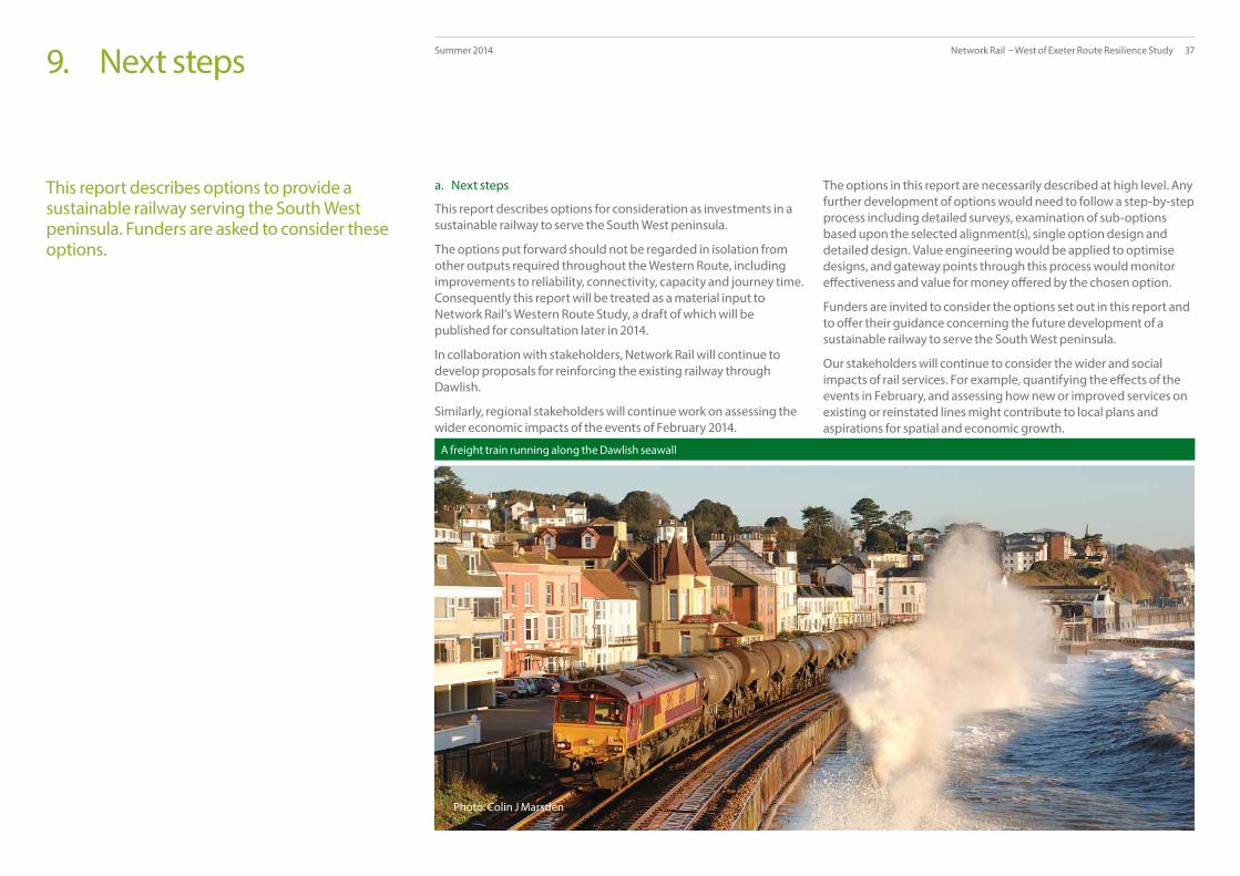
Network Rail – West of Exeter Route Resilience Study 37Summer 2014
This report describes options to provide a sustainable railway serving the South West peninsula. Funders are asked to consider these options.
a. Next steps
This report describes options for consideration as investments in a sustainable railway to serve the South West peninsula.
The options put forward should not be regarded in isolation from other outputs required throughout the Western Route, including improvements to reliability, connectivity, capacity and journey time. Consequently this report will be treated as a material input to Network Rail’s Western Route Study, a draft of which will be published for consultation later in 2014.
In collaboration with stakeholders, Network Rail will continue to develop proposals for reinforcing the existing railway through Dawlish.
Similarly, regional stakeholders will continue work on assessing the wider economic impacts of the events of February 2014.
The options in this report are necessarily described at high level. Any further development of options would need to follow a step-by-step process including detailed surveys, examination of sub-options based upon the selected alignment(s), single option design and detailed design. Value engineering would be applied to optimise designs, and gateway points through this process would monitor eff ectiveness and value for money off ered by the chosen option.
Funders are invited to consider the options set out in this report and to off er their guidance concerning the future development of a sustainable railway to serve the South West peninsula.
Our stakeholders will continue to consider the wider and social impacts of rail services. For example, quantifying the eff ects of the events in February, and assessing how new or improved services on existing or reinstated lines might contribute to local plans and aspirations for spatial and economic growth.
9. Next steps
Photo: Colin J Marsden
A freight train running along the Dawlish seawall

Appendices Network Rail – West of Exeter Route Resilience Study 38Summer 2014

Network Rail – West of Exeter Route Resilience Study 39Summer 2014A. Historical
The geography between Exeter and Plymouth presented challenges to the Victorian railway builders. The direct route has suff ered storm damage on many occasions.
Geography
The land between Exeter and Plymouth is hilly with many steep-sided river valleys. It is dominated by Dartmoor with large areas of high plateau. The coast is incised by a number of wide river valleys, including the Exe, the Teign and the Dart. There are many wide coves and bays and the coastline has steep cliff s along much of its length. This terrain proved diffi cult for the Victorian railway builders. Initial proposals included routes with long tunnels, long bridges or viaducts, and even a line with rope-worked inclines that crossed the centre of Dartmoor.
The three historical railway routes
The South Devon Railway opened its line between Exeter and Newton Abbot in stages during 1846 and 1847. Engineered by Isambard Kingdom Brunel, the route was chosen to provide a link between the towns along the coast including Starcross, Dawlish and Teignmouth. However, the route selection caused considerable diffi culty because of the terrain. Several inland routes were examined but eventually a route along the coast was selected. The line had to be constructed next to the sea. In some places a new embankment was built to take the line across inlets and coves. In other places short tunnels were cut through headlands. In 1876 the line was amalgamated with the Great Western Railway.
In 1890 the London & South Western Railway opened a competing route to Plymouth, running north and west of Dartmoor. This route was steeply graded, and several miles longer than the original GWR route. The Beeching report led to closure of the central section between Okehampton and Bere Alston in 1968, with the section between Coleford Junction and Okehampton fi nally closing to passengers in 1972.
The Teign Valley Railway was opened from Heathfi eld to Christow in 1882. The line was extended to Exeter to create a through route in 1903, and was built as a single line railway with passing loops. The line connected with the Newton Abbot to Moretonhampstead line at Heathfi eld, and was engineered for low speeds, with steep gradients and sharp curves. Because of low demand passenger trains were withdrawn in 1959. In 1961 fl ood damage caused the line to be closed for freight traffi c between Exeter and Christow.
Great Western Railway proposals for a new line
Storm damage to the line during the 1930s led the GWR to carry out a review of alternative routes. The fi rst of these was approved by Parliament in 1936 (the ‘Dawlish Warren route’) but a further breach of the railway at Powderham in 1936 meant that it was quickly superseded by a second route (the ‘Powderham route’). Further consideration by GWR engineers resulted in a third scheme being developed (the ‘Exminster route’). This received Parliamentary approval in 1937, and land was purchased. However the outbreak of the Second World War and economic diffi culties in its aftermath meant that the project was never realized.
British Rail’s proposals for an alternative route
British Rail looked at creating a diversionary route along the former London & South Western Railway route during the early 1990s in response to storm damage to the coastal railway. Although considered feasible, the proposal was not proceeded with.
No. 34067 approaches Brentor on the L&SWR route in 1961

Network Rail – West of Exeter Route Resilience Study 40Summer 2014A. Historical
A contemporary press report documenting damage to the railway during March 1962

Network Rail – West of Exeter Route Resilience Study 41Summer 2014A. Historical
A summary of historical storm damage to the coastal railway between Exeter and Newton Abbot
Winter 1846 The line was closed for three days.
Winter 1852/53 The line was closed twice, for seven and three days respectively.
February 1855 The line was closed for twelve days.
October 1859 The line was closed for three days.
January 1869 The line was closed for fi ve days.
Winter 1872/73 Four closures occurred, lasting one day, three days, three days and one day respectively.
March 1923 The line was closed for three days.
January 1930 The line was closed for three days.
February 1936 The line was closed for three days.
March 1962 The line was closed for part of a day, followed by single line working for several days.
February 1974 The line was again closed for part of a day, followed by single line working for several days.
February and March 1986 The line was closed for six days, followed by single track working for a further week.
January 1996 The line was closed for a week due to major damage at several points.
Winter 2000/2001 A major cliff fall closed the line for several days, and there was damage along the length of the sea wall.
19 November 2002 Wave-driven shingle damaged passing trains.
07 January 2004 The signalling system was rendered inoperative by heavy seas.
27 October 2004 Damage to sea wall masonry closed the line for three days. A train was immobilised at Sprey Point and passengers had to be evacuated by the Fire Brigade.
22 September 2006 Storms caused a void beneath the track, leading to one track being closed for several days.
14 December 2012 Both lines were closed due to fl ooding caused by waves breaking over the track.
08 April 2013 A 5mph emergency speed limit was imposed on the westbound track due to damage to the sea wall. The speed limit remained for several days.

Network Rail – West of Exeter Route Resilience Study 42Summer 2014
Location Priority Potential interventions Output Strategic issue Timescale / funding
Exeter to Dawlish Warren
3 • Enhancement of Environment Agency fl ood defences between Exeter and Powderham.
• Raising height of railway formation on existing alignment from Powderham to Dawlish Warren.
• Enhancement of culverts and drainage along railway alignment from Powderham to Dawlish.
• Enhancement of Southwest Water urban drainage network in Starcross and Dawlish Warren.
• Increased resilience to estuarine fl ooding.
• Reduction in duration of fl ooding landward of railway alignment.
• Reduction in fl ood risk to Powderham, Starcross and Dawlish Warren urban areas.
• Aligns with the ‘managed adaptive’ response to climate change
• Consistent with the Network Rail Western Route Climate Change Strategy.
• Also consistent with local strategy for Exe estuary as defi ned within the Shoreline Management Plan.
• Aligns with the Environment Agency investment plan.
• Exeter / Exminster Marshes to Powderham Banks works to be funded by additional Environment Agency funding.
• Powderham to Dawlish Warren to be funded in phases from Network Rail resources from the middle of Control Period 6 to end CP7 (2029).
• Flood defence improvements at the Kenn valley, Starcross and Cockwood to be funded by additional Environment Agency funding.
• Urban drainage improvements to be funded by Southwest Water
Dawlish Warren to Kennaway Tunnel
1 • Strengthening of seawall wall by raising lower sections of the walkway (in progress).
• Raising height and increasing width of wall along entire segment length including improved water run-off , revetment construction and toe piling.
• Construction of off shore “bar” to reduce wave impact energy.
• Programme of beach replenishment; Permanent way changes to improve resilience to wave run-off .
• Improved resilience to signalling and telecoms infrastructure; improved resilience of cliff lines by netting and anchoring.
• Increased resilience to wave impact damage and overtopping.
• Reduction in energy of waves impacting beach
• Restoration of historic beach profi le and improved longshore drift.
• Faster recovery of services following high wave events; reduction in risk of cliff and rock slope failures.
• Aligns with the ‘no regrets’ approach.
• Consistent with the Network Rail Western Route Climate Change Plan.
• Consistent with local strategy for Dawlish coastline defi ned within the Shoreline Management Plan.
• Impacts of off shore bar and beach replenishment proposals on existing beach systems (e.g. Teignmouth, Dawlish Warren, Exmouth) requires extensive predictive modelling.
• Tactical strengthening of wall will be completed with Network Rail resources by Winter 2014/15.
• Sustainable management scheme to be delivered by the Environment Agency.
• Resilience improvement against modelled climate change parameters and marine erosion models to be funded in phases from Network Rail resources from the middle of CP5 to the end of CP6 (2024).
B. Potential interventions to strengthen the existing railway
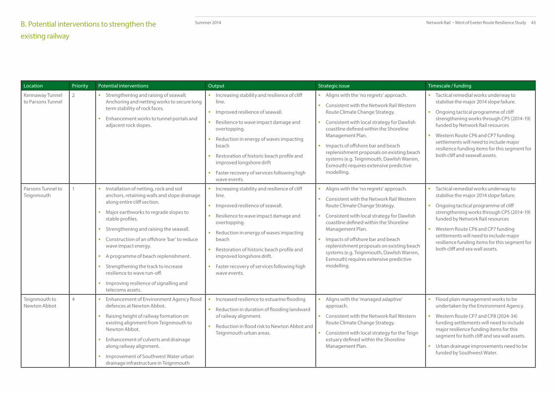
Network Rail – West of Exeter Route Resilience Study 43Summer 2014
Location Priority Potential interventions Output Strategic issue Timescale / funding
Kennaway Tunnel to Parsons Tunnel
2 • Strengthening and raising of seawall; Anchoring and netting works to secure long term stability of rock faces.
• Enhancement works to tunnel portals and adjacent rock slopes.
• Increasing stability and resilience of cliff line.
• Improved resilience of seawall.
• Resilience to wave impact damage and overtopping.
• Reduction in energy of waves impacting beach
• Restoration of historic beach profi le and improved longshore drift
• Faster recovery of services following high wave events.
• Aligns with the ‘no regrets’ approach.
• Consistent with the Network Rail Western Route Climate Change Strategy.
• Consistent with local strategy for Dawlish coastline defi ned within the Shoreline Management Plan.
• Impacts of off shore bar and beach replenishment proposals on existing beach systems (e.g. Teignmouth, Dawlish Warren, Exmouth) requires extensive predictive modelling.
• Tactical remedial works underway to stabilise the major 2014 slope failure.
• Ongoing tactical programme of cliff strengthening works through CP5 (2014-19)funded by Network Rail resources
• Western Route CP6 and CP7 funding settlements will need to include major resilience funding items for this segment for both cliff and seawall assets.
Parsons Tunnel to Teignmouth
1 • Installation of netting, rock and soil anchors, retaining walls and slope drainage along entire cliff section.
• Major earthworks to regrade slopes to stable profi les.
• Strengthening and raising the seawall.
• Construction of an off shore ‘bar’ to reduce wave impact energy.
• A programme of beach replenishment.
• Strengthening the track to increase resilience to wave run-off .
• Improving resilience of signalling and telecoms assets.
• Increasing stability and resilience of cliff line.
• Improved resilience of seawall.
• Resilience to wave impact damage and overtopping.
• Reduction in energy of waves impacting beach
• Restoration of historic beach profi le and improved longshore drift.
• Faster recovery of services following high wave events.
• Aligns with the ‘no regrets’ approach.
• Consistent with the Network Rail Western Route Climate Change Strategy.
• Consistent with local strategy for Dawlish coastline defi ned within the Shoreline Management Plan.
• Impacts of off shore bar and beach replenishment proposals on existing beach systems (e.g. Teignmouth, Dawlish Warren, Exmouth) requires extensive predictive modelling.
• Tactical remedial works underway to stabilise the major 2014 slope failure.
• Ongoing tactical programme of cliff strengthening works through CP5 (2014-19)funded by Network Rail resources
• Western Route CP6 and CP7 funding settlements will need to include major resilience funding items for this segment for both cliff and sea wall assets.
Teignmouth to Newton Abbot
4 • Enhancement of Environment Agency fl ood defences at Newton Abbot.
• Raising height of railway formation on existing alignment from Teignmouth to Newton Abbot.
• Enhancement of culverts and drainage along railway alignment.
• Improvement of Southwest Water urban drainage infrastructure in Teignmouth
• Increased resilience to estuarine fl ooding
• Reduction in duration of fl ooding landward of railway alignment.
• Reduction in fl ood risk to Newton Abbot and Teignmouth urban areas.
• Aligns with the ‘managed adaptive’ approach.
• Consistent with the Network Rail Western Route Climate Change Strategy.
• Consistent with local strategy for the Teign estuary defi ned within the Shoreline Management Plan.
• Flood plain management works to be undertaken by the Environment Agency.
• Western Route CP7 and CP8 (2024-34) funding settlements will need to include major resilience funding items for this segment for both cliff and sea wall assets.
• Urban drainage improvements need to be funded by Southwest Water.
B. Potential interventions to strengthen the existing railway

Network RailKings Place 90 York Way London N1 9AG
www.networkrail.co.uk


