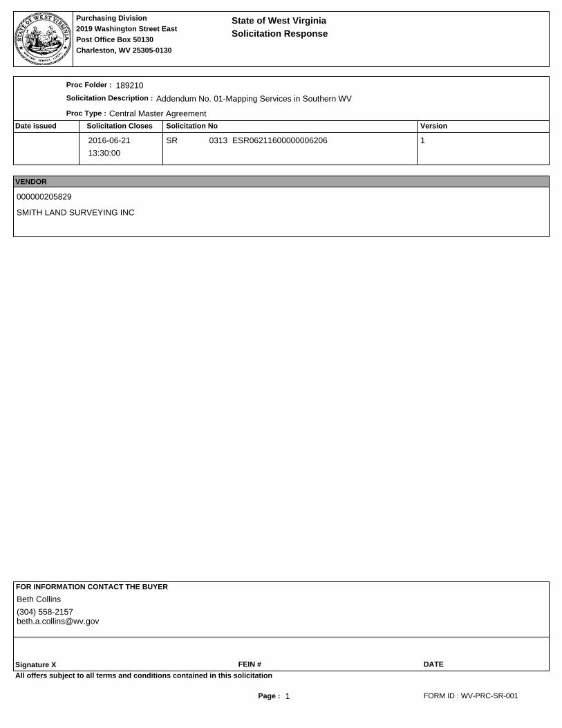
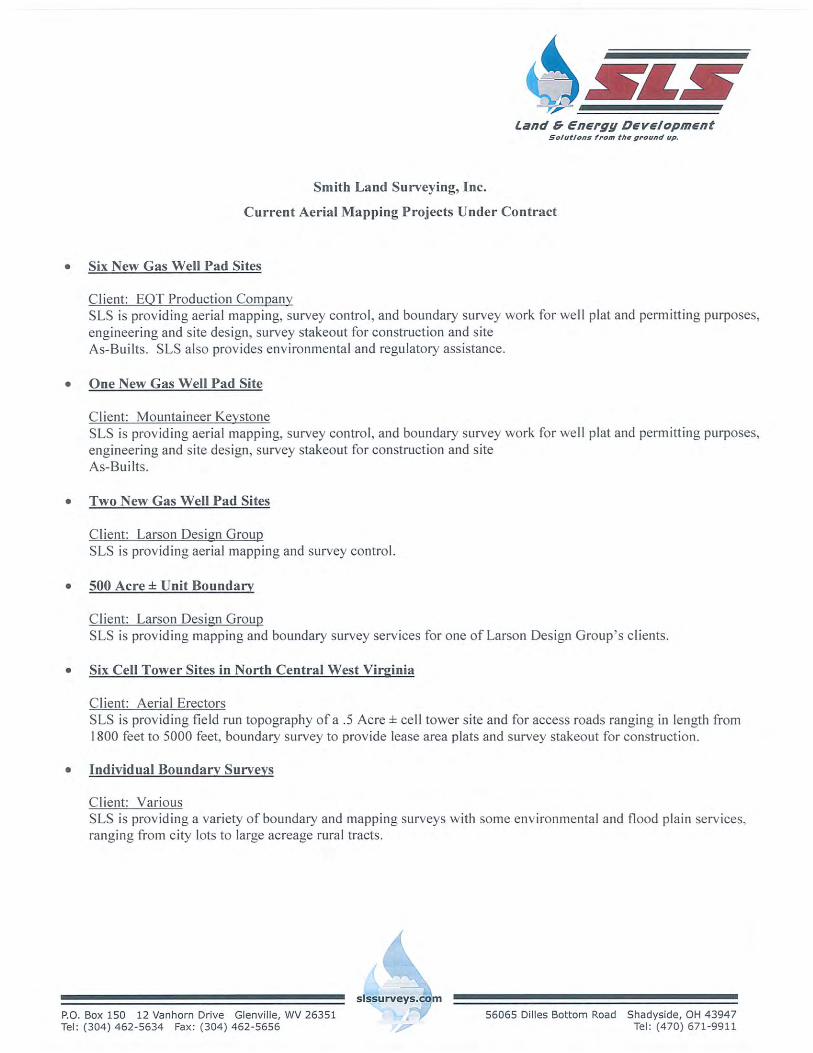
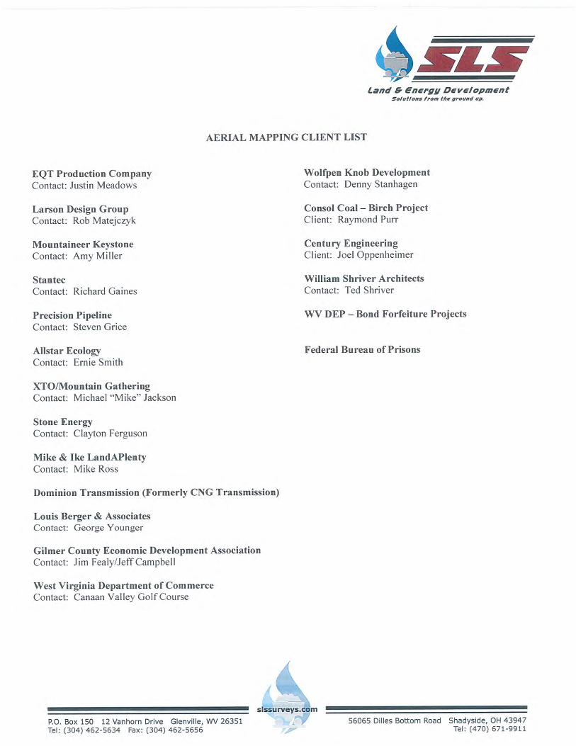
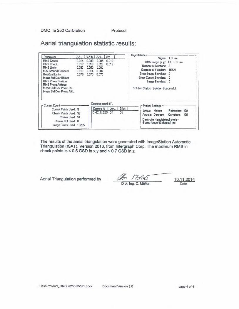
The following documentation is an electronically‐ submitted vendor response to an advertised solicitation from the West Virginia Purchasing Bulletin within the Vendor Self‐Service portal at wvOASIS.gov. As part of the State of West Virginia’s procurement process, and to maintain the transparency of the bid‐opening process, this documentation submitted online is publicly posted by the West Virginia Purchasing Division at WVPurchasing.gov with any other vendor responses to this solicitation submitted to the Purchasing Division in hard copy format.
Transcript
The following documentation is an electronically‐submitted vendor response to an advertised solicitation from the West Virginia Purchasing Bulletin within the Vendor Self‐Service portal at wvOASIS.gov. As part of the State of West Virginia’s procurement process, and to maintain the transparency of the bid‐opening process, this documentation submitted online is publicly posted by the West Virginia Purchasing Division at WVPurchasing.gov with any other vendor responses to this solicitation submitted to the Purchasing Division in hard copy format.
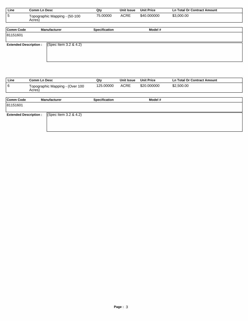
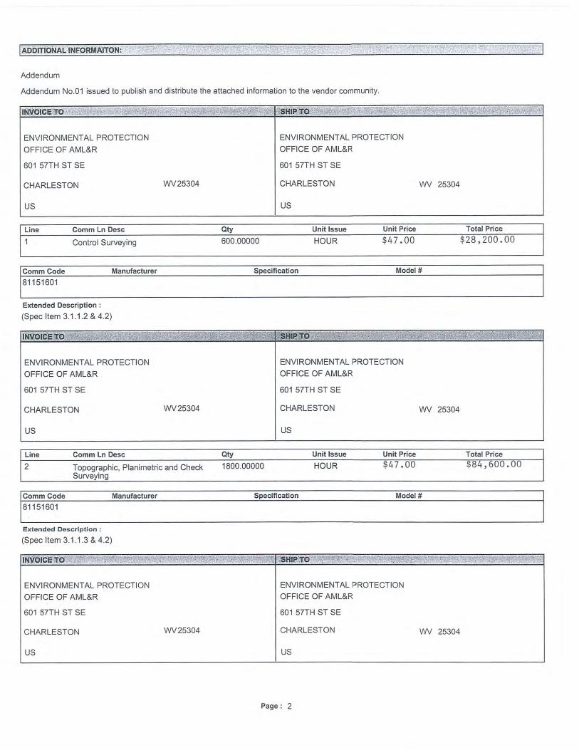
Line Comm Ln Desc Qty Unit Issue Unit Price Ln Total Or Contract Amount
Comm Code Manufacturer Specification Model #
Extended Description :
5 Topographic Mapping - (50-100Acres)
75.00000 ACRE $40.000000 $3,000.00
81151601
(Spec Item 3.2 & 4.2)
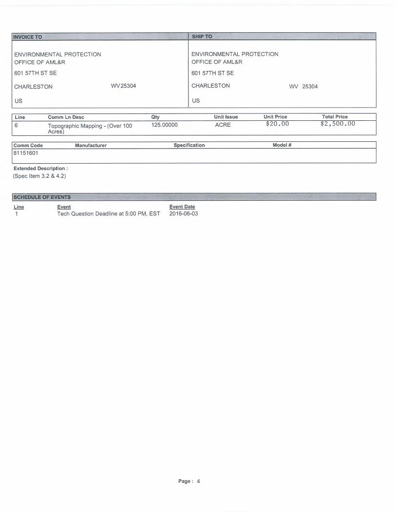
Line Comm Ln Desc Qty Unit Issue Unit Price Ln Total Or Contract Amount
Comm Code Manufacturer Specification Model #
Extended Description :
6 Topographic Mapping - (Over 100Acres)
125.00000 ACRE $20.000000 $2,500.00
81151601
(Spec Item 3.2 & 4.2)
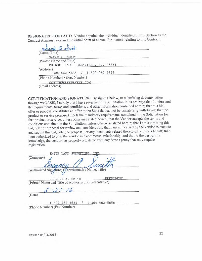
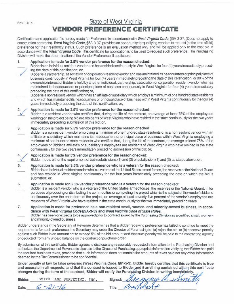
GREGORY A. SMITH
President
SMITH LAND SURVEYING, INC.
Education/Special Training
A.S. Degree in Land Surveying - Glenville State College - 1976
American Congress on Surveying & Mapping, Association of Photogrammetry & Photo Interpretation (1.3 units)
US Geological Survey National Mapping Center Resources & Information
Land Sat Image Interpretation at Purdue University Bluefield State College Land Surveying Seminar (1.6 units) Pennsylvania State University Computer & Business Courses
(2.1 units 1986), Photogrammetry & Business (2.1 units 1985) Soil Erosion & Sediment Control Plans (1986) Spill Prevention Control & Countermeasure Plans Computer Training at CLM Systems, Tampa, FL. Auto Cad Training at Putnam County Training Center Surface Mine Permitting & Regulations (1990) - WV Dept. of
Energy Geographic Information System (1990) - RDA Associates,
Maryland Design & Permitting for Water & Sewer Systems
(1991) - WV Dept. of Health Erosion & Sediment Control (1991) - WV Dept. of Natural
Resources Global Position System - Technical & Use (1991) Wetlands Evaluation (1991) - EPA, US Army Corps, Fish &
Wildlife, & WV DNR Law Enforcement Program – National Standards Committee
- NCEES (1997) IRS Tax & Revenue Program for Employee Classification and
Audit (1998) National Geodetic System – Use and Standards (1998) Geodetic Control with GPS – NSG Program (1998)
GPS Advancements/ Applications for Mountainous Terrain
(1999) Knud Hermanson – Boundary Litigation, the Surveyor &
Court (2000) Professionalism & Ethics for the Professional Surveyor
(2000) Flood Plane Management/National Flood Insurance Program
(2002) Influencing Public Policy to Meet the Needs of the Surveying
Profession (2002) Boundary Law and Legal Aspects of Surveying (2002) Risk of Doing Business Liability & Regulatory Compliance
(2003) Knud Hermanson – Minimum Standards for Boundary
Surveys (2003) Charm School for Surveyors – Public & Client Relations
(2004) WVSPS Floodplain Management (2006) Knud Hermanson – Minimum Standards & Ethics (2007) Surveyor’s Use of Historical Maps (2007) NCEES Meeting – Expanding the Scope of Surveying
Practice (2007)
Professional Organizations
Director for WVALS (1984-1989) Legislative Chairman for State Surveyors Association (1987-
present) Exam Evaluation Committee for NCEE (1988-1989) President Elect WVALS (1989 – President 1990 – 1991) Glenville State College Advisory Board – Land Surveying Glenville State College Advisory Board – Environmental
Technology Glenville State College Advisory Board – Natural Resources
Management Glenville State College Advisory Board – Landman Program
(2002 & 2006)
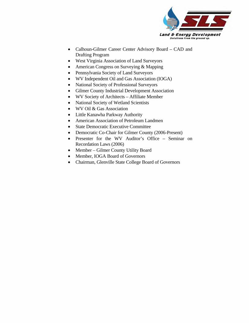
Calhoun-Gilmer Career Center Advisory Board – CAD and
Drafting Program West Virginia Association of Land Surveyors American Congress on Surveying & Mapping Pennsylvania Society of Land Surveyors WV Independent Oil and Gas Association (IOGA) National Society of Professional Surveyors Gilmer County Industrial Development Association WV Society of Architects – Affiliate Member National Society of Wetland Scientists WV Oil & Gas Association Little Kanawha Parkway Authority American Association of Petroleum Landmen State Democratic Executive Committee Democratic Co-Chair for Gilmer County (2006-Present) Presenter for the WV Auditor’s Office – Seminar on
Recordation Laws (2006) Member – Gilmer County Utility Board Member, IOGA Board of Governors Chairman, Glenville State College Board of Governors
Charles Victor Moyers
Senior Licensed Professional Surveyor
SMITH LAND SURVEYING, INC.
Education
Glenville State College, Glenville, West Virginia Associate in Science in Land Surveying
Professional Organizations
o Former National Exam Evaluation Committee for NCEES—Invitation Only (1992 & 2005)
o Former Member and Chapter Representative for Central Chapter of WVALS
o Former WV Association of Land Surveyors (Now WVSPS) Board of Directors Member, Vice President & President
o Current Member of Professional Land Surveyors of Ohio (PLSO)
Profile Mr. Vic Moyers was licensed as West Virginia Professional Surveyor No. 849 in 1988. When starting for SLS in 1988, he already had over eight years’ experience in office and field aspects of boundary, oil and gas, and mining surveys. Since then, has worked as Project Surveyor in charge of supervision of surveying oil and gas well locations, pipeline surveys, boundary surveys, control surveys, highway (route) surveys including centerline, cross-section and profile work with all related computations and calculations. Vic’s experience includes supervision and planning of GPS projects as well as processing GPS record research, as-built surveys, topographic mapping, strip mine pit and stockpile volumes, field reconnaissance, instrument man, office calculations & drafting. He has managed several large surveying/mapping projects such as Coal Company purchase of 30+ parcels totaling over 1500 Acres, government purchase/acquisition of over 200
parcels of land for construction and flood easements for the North Fork of Hughes River Dam Project, several miles of four land highway control, stake-out and property acquisition, GPS control surveys for aerial photo mapping projects for commercial development projects, many miles of gas pipeline surveys for construction and permitting. He also supervised all preliminary boundary surveying and topographic mapping for the Federal Prison site in Preston County, West Virginia and normal supervises the surveying of numerous oil and gas related surveys each year and several property surveys. His experience also includes boundary disputes and has served as an expert witness in court proceedings in disputes and property acquisition/condemnations.
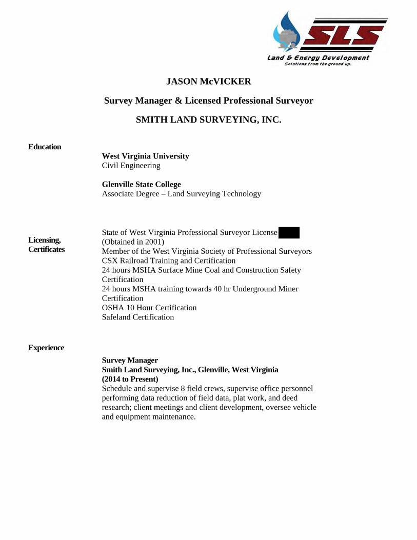
JASON McVICKER
Survey Manager & Licensed Professional Surveyor
SMITH LAND SURVEYING, INC.
Education
West Virginia University Civil Engineering
Glenville State College Associate Degree – Land Surveying Technology
Licensing, Certificates
State of West Virginia Professional Surveyor License (Obtained in 2001) Member of the West Virginia Society of Professional Surveyors CSX Railroad Training and Certification 24 hours MSHA Surface Mine Coal and Construction Safety Certification 24 hours MSHA training towards 40 hr Underground Miner Certification OSHA 10 Hour Certification Safeland Certification
Experience Survey Manager Smith Land Surveying, Inc., Glenville, West Virginia (2014 to Present) Schedule and supervise 8 field crews, supervise office personnel performing data reduction of field data, plat work, and deed research; client meetings and client development, oversee vehicle and equipment maintenance.
Field Supervisor and Crew Chief Blue Mountain Engineering, Wadestown, West Virginia (2012 to 2014) Schedule and supervise 2-5 field crews, on well pad and pipeline survey work as well as title mapping work. Supervise 3+ office personnel performing data reduction of field data, plat work, and deed research, client project manager for gas client, client meetings. Survey Project Manager Herbert, Rowland & Grubic, Inc., Morgantown, West Virginia (2012) Schedule and supervise 2-5 field crews, supervise 3+ office personnel performing data reduction of field data, plat work, and deed research, client project manager for gas client, field reviews for new gas well pad sites, construction management, client meetings, and help to supervise construction management staff, oversee vehicle and equipment maintenance.
Survey Supervisor Triad Engineering, Inc., Morgantown, West Virginia (2011-2012) Management of GPS field operations and equipment, training of staff on GPS field operations and equipment, and field equipment purchasing. Management of coal and oil & gas survey work, job estimates and bids, billing review and over-site, project management for a variety of survey projects ranging from small to large, including rural and residential boundary surveys, topographic surveys, aerial flight control, control surveys, surface mine related surveys, construction stakeout on jobs varying from roadways and site work to concrete and steel work, and Railroad surveys for construction.
Project Manager Greenway Engineering, Inc., Winchester, Virginia (2003-2011) Management of up to 6 office staff, job estimates and bids, project management for a variety of survey projects ranging from small to large, including rural and residential boundary surveys, topographic surveys, aerial flight control, control surveys, surface
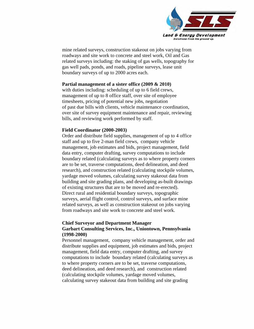
mine related surveys, construction stakeout on jobs varying from roadways and site work to concrete and steel work, Oil and Gas related surveys including: the staking of gas wells, topography for gas well pads, ponds, and roads, pipeline surveys, lease unit boundary surveys of up to 2000 acres each. Partial management of a sister office (2009 & 2010) with duties including: scheduling of up to 6 field crews, management of up to 8 office staff, over site of employee timesheets, pricing of potential new jobs, negotiation of past due bills with clients, vehicle maintenance coordination, over site of survey equipment maintenance and repair, reviewing bills, and reviewing work performed by staff. Field Coordinator (2000-2003) Order and distribute field supplies, management of up to 4 office staff and up to five 2-man field crews, company vehicle management, job estimates and bids, project management, field data entry, computer drafting, survey computations to include boundary related (calculating surveys as to where property corners are to be set, traverse computations, deed delineation, and deed research), and construction related (calculating stockpile volumes, yardage moved volumes, calculating survey stakeout data from building and site grading plans, and developing as-built drawings of existing structures that are to be moved and re-erected). Direct rural and residential boundary surveys, topographic surveys, aerial flight control, control surveys, and surface mine related surveys, as well as construction stakeout on jobs varying from roadways and site work to concrete and steel work.
Chief Surveyor and Department Manager Garbart Consulting Services, Inc., Uniontown, Pennsylvania (1998-2000) Personnel management, company vehicle management, order and distribute supplies and equipment, job estimates and bids, project management, field data entry, computer drafting, and survey computations to include boundary related (calculating surveys as to where property corners are to be set, traverse computations, deed delineation, and deed research), and construction related (calculating stockpile volumes, yardage moved volumes, calculating survey stakeout data from building and site grading
plans, and developing as-built drawings of existing structures that are to be moved and re-erected). Direct and perform rural and residential boundary surveys, topographic, aerial flight control, control surveys, underground and surface mine related surveys, as well as construction stakeout on jobs varying from roadways and site work to concrete and steel work.
Earl Thompson
Project Manager & Licensed Professional Surveyor
SMITH LAND SURVEYING, INC.
Education
Glenville State College AS – 1994 Land Surveying
Licensing
State of West Virginia Professional Surveyors License Class A CDL Driver’s License Fuel Handling Safety (2203) ABS Brake System Class (2003) Warehouse Safety & Chemical Neutralization Class (2003) Airborne Hazards Class (2004)
Experience Has experience in hand drafting and entries of field notes. Experienced on the operating systems of Carlson Software
and several versions of Auto-CAD systems. Has experience in the operation of data collection devices
and on site calculations and decisions. Has worked as a Project Surveyor in charge of surveying
oil and gas well locations, and boundary and partition surveys.
Experienced with pipeline profiles for both road and stream crossings, GPS data processing, construction stake-outs, courthouse research, topographic surveys and mapping, field reconnaissance, all positions on field crews, and drafting. Has been in charge of several projects for EQT including both office and field sides.
Experienced with controlling multiple crews
simultaneously and public relations and with designing multiple well pad locations and spacing plans of horizontal well paths.
Has been in charge of and overseen the operation and checking of levels which was performed for a coal company consisting of approximately 1.5 miles located in Wyoming County, WV. And was in charge of the stake-out for tower bases and most of the As- Builts for this project as well.
Marked many miles of seismic lines using long-hand calculations on site in Southern Kentucky.
Several years of experience as an over-the-road truck driver, mechanics on tractor trailers and many military vehicles and associated components.
Experienced with the operation and mechanics of several different pieces of heavy equipment such as bulldozers, trackhoes, backhoes, and fork lifts.
Matthew J. Hilton, Jr.
Project Manager & Licensed Professional Surveyor
SMITH LAND SURVEYING, INC.
Education
Glenville State College AS – Land Surveying
Licensing
State of West Virginia Professional Surveyors License OSHA 10 Hour Certification Heartsaver First Aid, CPR
Experience 2011-Present Smith Land Surveying, Inc., Glenville, West Virginia - Project Manager Monitor the progress of projects under my supervision, check well plats and rec plans, perform boundary surveys and compute corners, prepare for drafting, perform level loops and compute elevations for elevation certificates and Loma surveys
2009-2011 Allegheny Surveys Inc., Birch River, West Virginia - Senior Party Chief Staked gas wells and prepared plats and rec plans for drafting, topo’d coal mine stock piles using conventional and survey grade GPS, set control points using survey grade GPS, set control points using survey grade GPS, ran field crews on boundary surveys.
2009-2009 Pocahontas Coal Company, Beckley, West Virginia - Survey Helper Assist in setting spads in high wall for lining up high wall mining equipment, assist in running traverse and set bore hole stake, assist in as-built for access roads and high wall reclamation.
2006-2009 Allegheny Surveys Inc., Birch River, West Virginia - Senior Party Chief Staked gas wells and prepared plats and rec plans for drafting, topo coal mine stock piles using conventional and survey grade GPS, set control points using survey grade GPS, ran field crews on boundary surveys. 2001-2006 Smith Land Surveying Inc., Glenville, West Virginia - Field Technician/Party Chief Assist in staking gas wells and access roads, assist with performing boundary surveys, assist with construction surveys, became party chief and began staking gas wells, laying out access roads and preparing well plats for drafting, ran boundary survey crews and helped with the computation of boundary corners and preparing plats and description for drafting, ran level loops and computed elevations for elevation certificates. 1999-2001 Smith Land Surveying Inc., Glenville, West Virginia Assist with the project at hand, which included giving back-sights, head chaining on boundary surveys, assist in staking gas wells.
Leslie Pierce
Project Manager & Licensed Professional Surveyor
SMITH LAND SURVEYING, INC.
Education
1967 - King High School- Tampa, Fl 1968-2012 - Continuing educational seminars and training in surveying and business management 2012 - Phase 1 ESA Training (ER-Due Diligence at Dawn Seminar)
Licensing
State of Florida Professional Surveyors License
Experience 2010-Present Project Surveyor, Smith Land Surveying, Inc. Responsibilities include Phase1 Environmental Site Assessments, road condition surveys and reports, preparation of permit applications for local, state and federal agencies, research public records, QAC of field and office data, prepare maps and reports for field surveys.
2009-2010 Self Employed Professional Surveyor (Florida) Provide professional land surveying and related consulting services to private and public clients. Provide boundary, topographic, photogrammetric control, accident surveys, right of way surveys, subdivision platting and hydrographic surveys.
2006-2009 Hillsborough County Florida-Manager of County Survey Field Office Managed survey field office for Hillsborough County, Florida. Responsibilities included day to day operations of surveying office and personnel, develop budgets, perform and prepare boundary, topographic, environmental surveys. Provide surveys and data to public and private clients. Establishment of continuously operating GPS reference base stations. Supervised staff in the use of flatbed photogrammetric scanners. Provided QA/QC on photogrammetric projects. Prepared photo overlay exhibits for proposed highway related projects used in property acquisition and eminent domain proceedings. Established three dimensional survey control for large and small projects.
1997-2006 Hillsborough County Florida-Manager of County Right of Way Section Responsible for management of 20 + staff and contract with 21 surveying and mapping consulting firms. Perform quality control for subdivision platting, road right of way surveys, road design plans and photogrammetric mapping. Created inter-local agreements with other government organizations, develop budget, maintain technical hardware and software. Developed countywide right of way inventory program. Created specifications for individual and county-wide aerial mapping projects (included 1,000 square miles semi-annual flights) both film and digital base. Negotiated and managed contracts for over six photogrammetric consultant contracts. Supervised photogrammetric staff in data acquisition by use of analog and digital stereoplotters 1990-1997 Hillsborough County Florida-Professional Surveyor 1986-1990 Delta Engineering Corporation-Chief of Surveying 1968-1986 Delta Engineering Corporation-Professional Surveyor
Ken Simmons
CADD Specialist / IT Manager
SMITH LAND SURVEYING, INC.
Education
Lewis County High School, graduate Fairmont State University AS in Civil Engineering Glenville State College, BA in Sociology / Psychology
Certifications
Nine Years of office supervisory experience
Twenty/five years of Auto CADD experience
Experienced in field work
OSHA certified in Construction Safety and Health 10 Hour
ComTIA certification in A+
ComTIA certification in Linux+
ComTIA certification in Server+
DCA (Dell Certified Associate)
Experience IT/CADD Specialist, Smith Land Surveying (2008-current)
Design land features such as ponds, pads and drains using Carlson Civil Software. Create Topographical data for Quantities for cut and fill. Created and continue to update written job descriptions for office personnel. Developed manual for all business office procedures, resulting in standardized operations. Well Plats, Permits, and Exhibits. Design of Site Plans for Marcellus Shale Gas Wells. Take care of all computer and network issues.
Design land features such as ponds, pads and drains using Civil Land Desktop. Create Topographical data for Quantities for cut and fill. Deed research and right-of-way information for P.S.D. related jobs and work done for Eastern Coal. Created and continue to update written job descriptions for office personnel. Developed manual for all business office procedures, resulting in standardized operations. Worked primarily for pipeline, pipeyard and test stations for four years.
Office Manager, Wheeler, Jackson and Ferrell, Inc. (2004)
Performed business office duties. Field work as instrument man as well as court research. Survey plats using Eagle Point software. Ordered office and survey supplies.
Cadd Tech. Smith Land Surveying (2001-2004)
Survey and Well Plats using Carlson Software. Field Work as a rod man
Cadd Tech. & Field Crew, D. L. Wheeler and Associates (1991-2001)
Survey, Mortgage and Alta plats using Auto Cadd and Eagle Point software. Field work as a rod man and as instrument man.
2012 - Present Smith Land Surveying Glenville, WV Geotechnical Drilling Manager / CAD & GIS Specialist
Prepare base mapping and topographic mapping for multiple engineering and as-built sites.
Complete as-built survey plats from start to finish.
Worked on multiple proposed pipeline surveys.
Prepared and set up information for geodatabasing in GIS.
Drafting well plats, road approaches, and reclamation plans.
Managing Geotechnical Drilling operations.
Organizing and completing geotechnical testing evaluations.
Setup final designs through Carlson Construction for use on Caterpillar and other GPS equipment for well site construction.
Mapping and topo work with Cyclone and other Point Cloud software.
Designing rough / preliminary pad and access road locations.
Converting design files to shape files for client geodatabasing.
Preparing exhibit maps and information for environmental permitting.
Completing road condition surveys from start to finish.
2006-2012 Thrasher Engineering Inc. Bridgeport, WV Survey CAD Technician
Worked under five WV Licensed Surveyors and eight WV/PA licensed Professional Engineers.
Drafted multiple property, easement, condemnation, well, and permit plats.
Received information from field crews on a daily basis and updated base mapping and topographic mapping for the engineers and GIS departments
Drafted as-built surveys and Alta surveys from start to finished product.
Completed over 1000 miles of proposed and as-built pipeline surveys, working both indoors doing drafting / engineering, and outdoors surveying.
Worked on long wall mining mapping and water sampling on multiple jobs, covering over 2000 homes and businesses, both in office and out. Doing water well sampling and mapping for every sampled home or business in the project area (within a 2-mile radius of a long wall mine).
EDUCATION
2002-2005 South Harrison High School Lost Creek, WV
Completed courses in board and computer aided drafting.
Graduated with a 3.0 grade average.
2004-2005 United Technical Center Clarksburg, WV
Completed 1000 hours of drafting training in a two year course.
The first year in the course was for mechanical drafting and design.
During the first year in the course I won 3rd place in the state for the VICA mechanical drafting competition.
The second year of the course was for architectural drafting.
During the second year of the course I won 1st place at the state level VICA architectural competition and 15th in the National VICA competition for architectural drafting.
2005-2007 Fairmont State University Fairmont/Clarksburg, WV
Completed 1.5 semesters in the civil engineering program.
50 hours of Autodesk Land Desktop training.
SOFTWARE EXPERIENCE
I have multiple years of experience with 2009 Autodesk Land Desktop, 2010-2014 Carlson with Autodesk, and 2010-2012 Autodesk Civil 3D. I also have roughly three years of experience with Carlson GIS, ESRI ArcGIS, general point cloud software, and Carlson Construction.
INTERESTS I enjoy spending time with my children and family, also golfing, hunting, fishing, dirt track racing, donating time to raise money for my Shriners organization, and taking kids to and from multiple Shriners hospital locations.