The following documentation is an electronically‐ submitted vendor response to an advertised solicitation from the West Virginia Purchasing Bulletin within the Vendor Self‐Service portal at wvOASIS.gov. As part of the State of West Virginia’s procurement process, and to maintain the transparency of the bid‐opening process, this documentation submitted online is publicly posted by the West Virginia Purchasing Division at WVPurchasing.gov with any other vendor responses to this solicitation submitted to the Purchasing Division in hard copy format.
Transcript
The following documentation is an electronically‐submitted vendor response to an advertised solicitation from the West Virginia Purchasing Bulletin within the Vendor Self‐Service portal at wvOASIS.gov. As part of the State of West Virginia’s procurement process, and to maintain the transparency of the bid‐opening process, this documentation submitted online is publicly posted by the West Virginia Purchasing Division at WVPurchasing.gov with any other vendor responses to this solicitation submitted to the Purchasing Division in hard copy format.
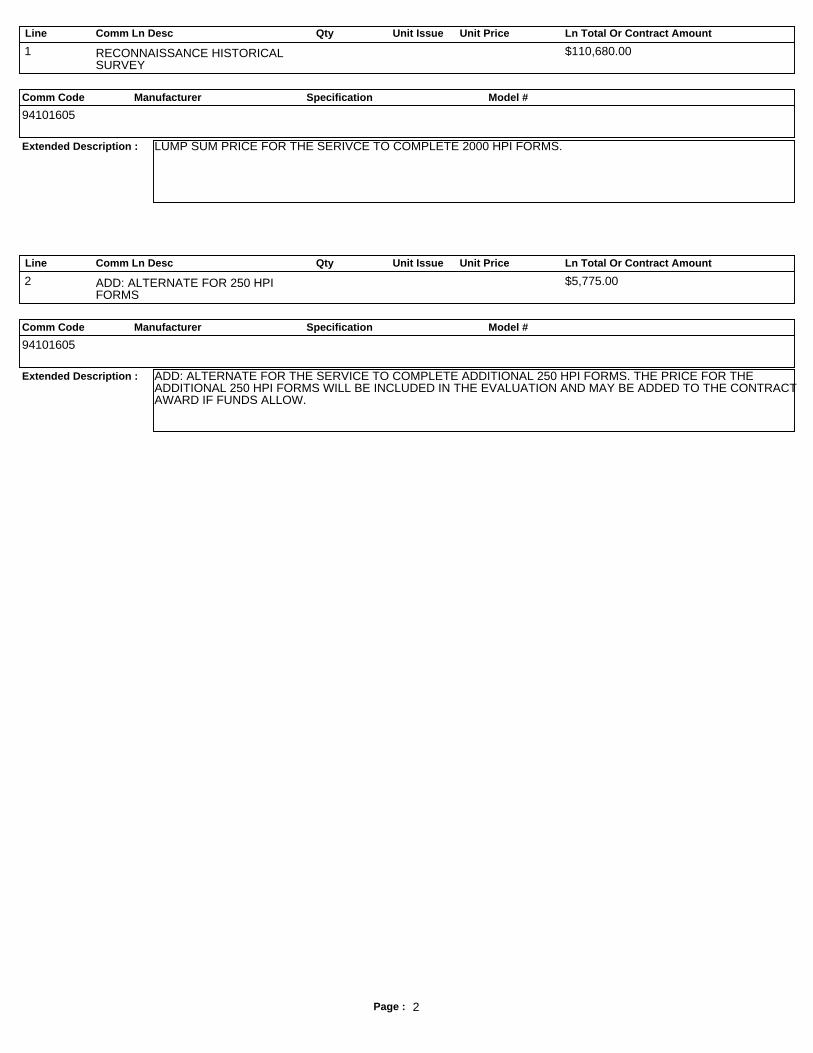
Line Comm Ln Desc Qty Unit Issue Unit Price Ln Total Or Contract Amount
Comm Code Manufacturer Specification Model #
Extended Description :
1 RECONNAISSANCE HISTORICALSURVEY
$110,680.00
94101605
LUMP SUM PRICE FOR THE SERIVCE TO COMPLETE 2000 HPI FORMS.
Line Comm Ln Desc Qty Unit Issue Unit Price Ln Total Or Contract Amount
Comm Code Manufacturer Specification Model #
Extended Description :
2 ADD: ALTERNATE FOR 250 HPIFORMS
$5,775.00
94101605
ADD: ALTERNATE FOR THE SERVICE TO COMPLETE ADDITIONAL 250 HPI FORMS. THE PRICE FOR THEADDITIONAL 250 HPI FORMS WILL BE INCLUDED IN THE EVALUATION AND MAY BE ADDED TO THE CONTRACTAWARD IF FUNDS ALLOW.
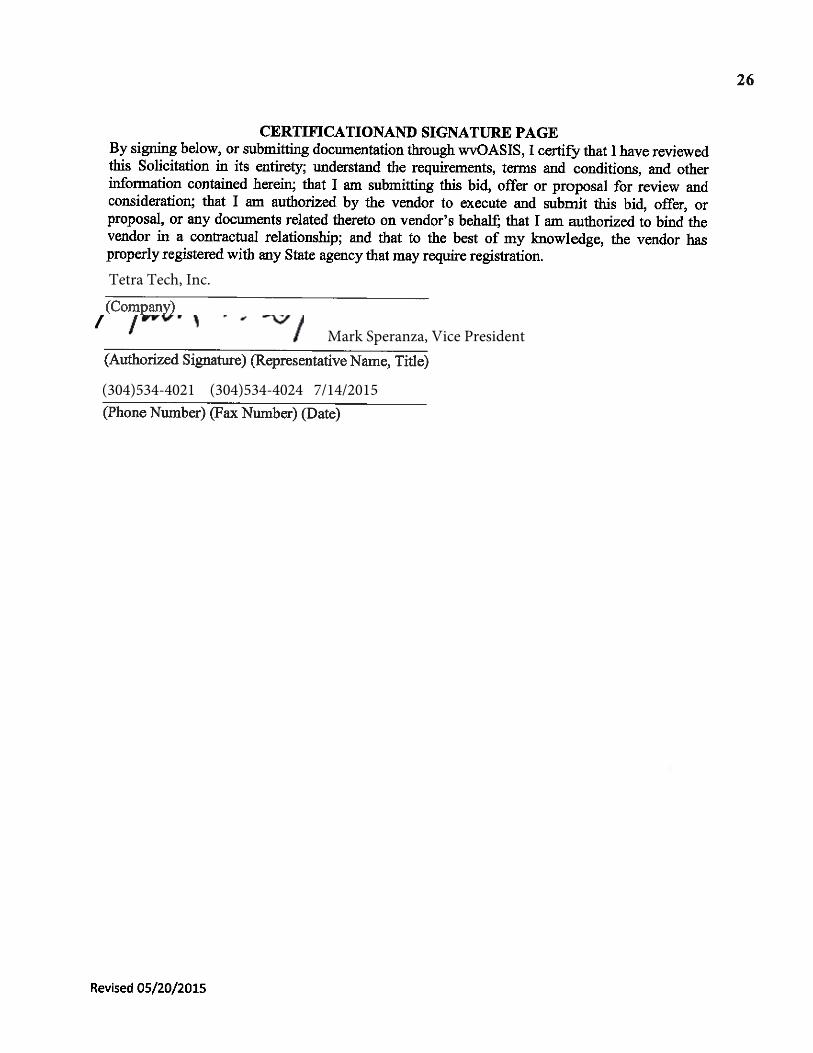
West Virginia Division of Culture & History Tetra Tech, Inc. Response to Request for Quotation: CRFQ_DCH1500000003 Hurricane Sandy Historic Resources Survey Submitted by: Tetra Tech, Inc. 1000 Green River Drive Fairmont, WV 26554 (304)534-4021
Request for Quotation
Tetra Tech, Inc.
Mark Speranza, Vice President
(304)534-4021 (304)534-4024 7/14/2015
mark.speranza
Mark Speranza Black
TABLE OF CONTENTS SECTION A…………………………………………………………Cover Letter, Assumptions, & Competence SECTION B…………………………………………………………RFQ Form SECTION C…………………………………………………………Addendum Acknowledgement SECTION D…………………………………………………………Personnel Resumes SECTION E…………………………………………………………Project Experience/References SECTION F…………………………………………………………Contract Manager Form
Section A: Cover Letter, Assumptions and Competence
July 14, 2015 Ms. Evelyn Melton Department of Administration, Purchasing Division 2019 Washington Street East, Charleston, West Virginia 25305-0130 Dear Ms. Melton: Tetra Tech is pleased to respond to your Request for Quotation for professional services to conduct an historic resources reconnaissance survey in reply to RFQ DCH1500000003 for the State of West Virginia. Our extensive experience completing large-scale cultural resources surveys in West Virginia and throughout the Eastern united States; our ability to mobilize and meet project deadlines with quality products; our excellent relationship with clients and the West Virginia Division of Culture and History—State Historic Preservation Office (WVDCH-SHPO); and the strengths of our staff are illustrated in the following response. Resumes for our key personnel are provided in Part 3 of this proposal. Tetra Tech’s architectural historians and cultural resources specialists have satisfied a wide variety of clients throughout West Virginia with our successful, timely, and cost-effective completion of a number of historic resources projects. Tetra Tech architectural historians have completed the cultural resources elements of successful projects ranging from disaster recovery (Tier 2 reviews for Hurricane Sandy Recovery Program) to comprehensive planning to utility expansion to gas pipeline construction to real estate development. These range from smaller survey and evaluation projects of approximately 100 resources, to large-scale projects involving identification and evaluation of over 1,200 resources. As a firm, Tetra Tech also has significant experience working for the state of West Virginia. We have managed projects for the West Virginia Department of Environmental Protection, Office of Special Reclamation, and Office of Abandoned Mine Lands. In addition, our Charleston office is currently managing Total Maximum Daily Load projects for the WVDEP. As requested by the RFQ we have submitted this response through WV OASIS. We appreciate this opportunity to provide this proposal, and look forward to answering any questions you may have. If you should require any additional information, please contact Ms. Warino at (304) 534-4021. Ms. Warino will serve the project in an administrative capacity. Respectfully,
Assumptions Upon receipt of Notice to Proceed, a detailed work plan and project schedule will be developed in coordination with WVDCH-SHPO; the proposed methodology and time table will be designed to meet the need and requirements of WVDCH-SHPO and NPS as detailed in RFQ DCH1500000003, specifically, No. 4: Mandatory Requirements. Tetra Tech assumes that the proposed work plan for this project will consist of four interrelated tasks: Meetings, Background Research and Development of Historic Contexts, Fieldwork and Data Collection, and Reporting (seven county reports and approximately 2,000 HPI forms). The Hurricane Sandy Historic Resource Reconnaissance Survey will be conducted according to Archaeology and Preservation: Secretary of the Interior’s Standards and Guidelines (48 FR 44716-44716-44742); National Register Bulletin 15-How to Apply the National Register Criteria for Evaluation (National Park Service 1998); and National Register Bulletin 21-Defining Boundaries for National Register Properties (National Park Service 1997), as well as applicable state guidelines for survey projects.
Competence Tetra Tech project architectural historians and cultural resources support personnel are grounded and proficient in the Secretary of the Interior’s Standards and Guidelines for Identification and Evaluation (48FR44716-28). Our staff members exceed the National Park Service qualifications of 36CFR61. In addition to the technical services outlined below, Tetra Tech offers a performance record in meeting project schedules, submitting timely and accurate recommendations, and producing high-quality reports and deliverables. These are all critical elements in the management of cultural resources, since any missing element can have a profound impact on planning commitments. The key personnel assembled for this project are skilled and experienced architectural historians and cultural resources specialists. The team members have performed numerous successful architectural and historical resource surveys, including those that have documented well over 500 resources per survey.
Large-Scale Historic Resource Survey Project Experience (Selected) Historic Agricultural Resources Survey for Greene and Washington County, Pittsburgh History & Landmarks Foundation, Pennsylvania 2006-2007
1,150 Resources Grand-Funded
Historic Resource Survey of the Murray Hill Neighborhood—Phase II, Jacksonville Planning and Development Department, 2009-2010
Tetra Tech cultural resources staff, though preparation of hundreds of West Virginia Historic Property Inventory (HPI) Forms and a number of architectural survey reports, has developed a keen understanding of the guidelines and procedures of the WVDCH-SHPO. The cultural resources specialists of Tetra Tech are familiar with the files and resources, including online databases, of many SHPOs, including WV SHPO’s Online GIS application; they have completed numerous searches of WV SHPO’s site files at its Charleston office. This familiarity, coupled with Tetra Tech’s active, successful relationship with the staff at WV SHPO, is essential for conducting background research and resource inventory studies effectively and efficiently. Our commitment to excellence has fostered a close working relationship with the staff of the state review agencies, as this ultimately facilitates thorough and accurate information transmittal, a crucial element of the cultural resources management process. Experience of Key Personnel (Resumes provided in Section D) Project Manager and Architectural Historian Hannah Dye, M.A. has completed large-scale surveys throughout West Virginia, and through her experience, has developed techniques for streamlining fieldwork while ensuring accuracy. Additionally, Ms. Dye works closely with Tetra Tech’s clients to ensure that project objectives are met and exceeded, with high quality deliverables and accurate recommendations. Recently, Ms. Dye has coordinated and performed the Historic Resource Survey for the 188-mile long Mountain Valley Pipeline (MVP) Project in Braxton, Doddridge, Fayette, Greenbrier, Harrison, Lewis, Monroe, Nicholas, Summers, Webster, and Wetzel Counties West Virginia for EQT Midstream Partners, LP. As a West-Virginia native, Ms. Dye maintains a close, working relationship with staffs at WCDCH’s state archives, the West Virginia and Regional History Collection at West University Libraries in Morgantown, and several county historical and genealogical societies. Lead Architectural Historian James Sexton, PhD. has extensive experience conducting numerous large- and small-scale reconnaissance-level surveys for various city planning departments, municipalities, state and federal agencies, and various organizations in both the public and private sectors throughout the Eastern United States. Dr. Sexton is adept at primary and secondary research that supports Tetra Tech’s architectural and historical studies to fully develop the historic contexts against which resources are evaluated. Architectural Historian Julia Mates, M.A. has completed architectural survey work in West Virginia, and during Tetra Tech’s recent survey for the MVP Project, Ms. Mates facilitated the identification and evaluation of approximately 250 resources. GIS Technicians Michael DiGuilio and Jim Herning are skilled at providing the crucial GIS mapping component of Tetra Tech’s architectural survey projects and closely works with governmental GIS
departments to coordinate an efficient delivery of geospatial data. Both Mr. DiGuilio and Mr. Herning have experience in providing GIS mapping to a wide variety of clients throughout the eastern United States, including a number in West Virginia. Courtney Smith, BA, BS complements the aforementioned staff and has been an integral part of the field staff for many of Tetra Tech’s cultural resources survey projects in West Virginia. The above staff is supported by a full range of technical support staff including community planners, emergency managers, engineers, surveyors, CADD technicians, and technical editors.
Section B: RFQ Form
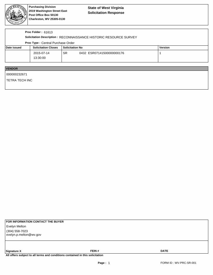
Page : 1
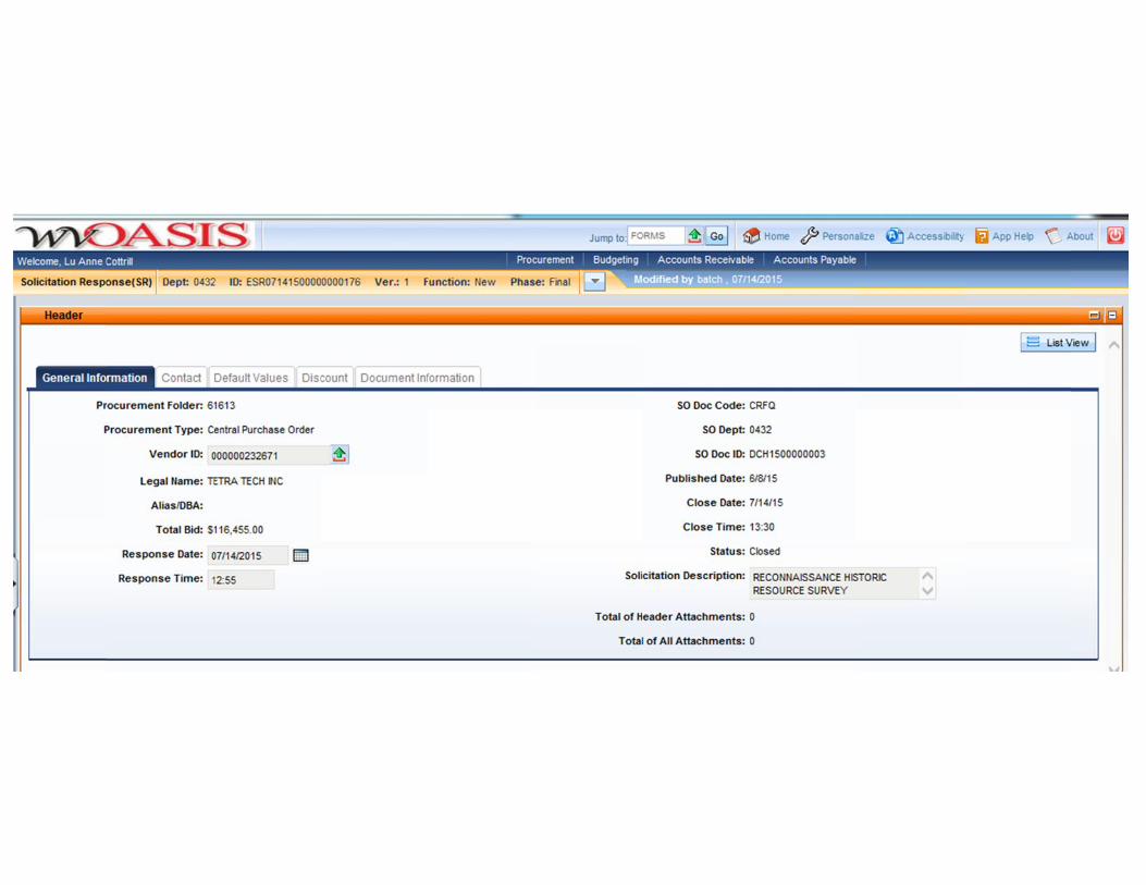
Proc Folder:
Doc Description:
Proc Type:
Date Issued Solicitation Closes Solicitation No Version
Request for QuotationState of West Virginia
2019 Washington Street EastPurchasing Divison
Post Office Box 50130Charleston, WV 25305-0130
61613
RECONNAISSANCE HISTORIC RESOURCE SURVEY
Central Purchase Order
2015-06-08 2015-07-1413:30:00
CRFQ 0432 DCH1500000003 1
BID RECEIVING LOCATION
VENDOR
Vendor Name, Address and Telephone Number:
BID CLERK
DEPARTMENT OF ADMINISTRATION
PURCHASING DIVISION
2019 WASHINGTON ST E
CHARLESTON WV 25305
US
FORM ID : WV-PRC-CRFQ-001
All offers subject to all terms and conditions contained in this solicitation
Tetra Tech, Inc. 1000 Green River DriveFairmont, WV 26554(304)534-4021
954148514 7/14/2015
mark.speranza
Mark Speranza Black
Page : 2
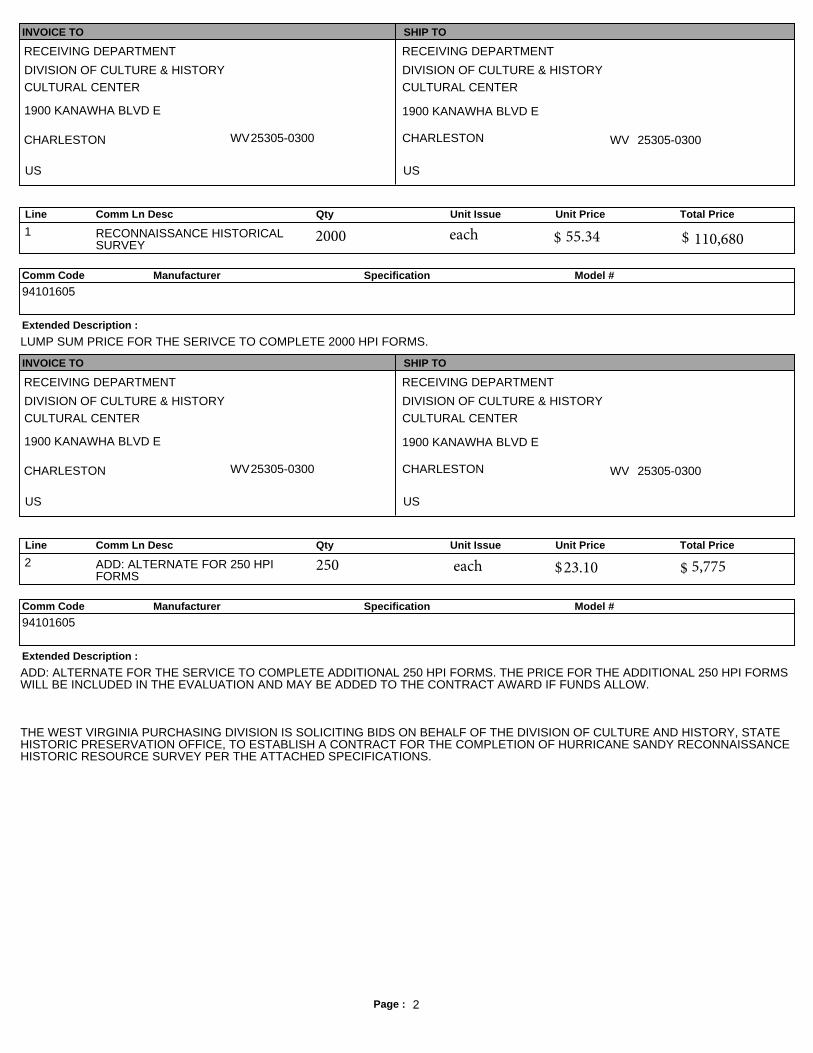
INVOICE TO SHIP TO
RECEIVING DEPARTMENT
DIVISION OF CULTURE & HISTORYCULTURAL CENTER
1900 KANAWHA BLVD E
CHARLESTON WV25305-0300
US
RECEIVING DEPARTMENT
DIVISION OF CULTURE & HISTORYCULTURAL CENTER
1900 KANAWHA BLVD E
CHARLESTON WV 25305-0300
US
Line Comm Ln Desc Qty Unit Issue Unit Price Total Price
1 RECONNAISSANCE HISTORICALSURVEY
Comm Code Manufacturer Specification Model #
Extended Description :
94101605
LUMP SUM PRICE FOR THE SERIVCE TO COMPLETE 2000 HPI FORMS.
INVOICE TO SHIP TO
RECEIVING DEPARTMENT
DIVISION OF CULTURE & HISTORYCULTURAL CENTER
1900 KANAWHA BLVD E
CHARLESTON WV25305-0300
US
RECEIVING DEPARTMENT
DIVISION OF CULTURE & HISTORYCULTURAL CENTER
1900 KANAWHA BLVD E
CHARLESTON WV 25305-0300
US
Line Comm Ln Desc Qty Unit Issue Unit Price Total Price
2 ADD: ALTERNATE FOR 250 HPIFORMS
Comm Code Manufacturer Specification Model #
Extended Description :
94101605
ADD: ALTERNATE FOR THE SERVICE TO COMPLETE ADDITIONAL 250 HPI FORMS. THE PRICE FOR THE ADDITIONAL 250 HPI FORMSWILL BE INCLUDED IN THE EVALUATION AND MAY BE ADDED TO THE CONTRACT AWARD IF FUNDS ALLOW.
THE WEST VIRGINIA PURCHASING DIVISION IS SOLICITING BIDS ON BEHALF OF THE DIVISION OF CULTURE AND HISTORY, STATEHISTORIC PRESERVATION OFFICE, TO ESTABLISH A CONTRACT FOR THE COMPLETION OF HURRICANE SANDY RECONNAISSANCEHISTORIC RESOURCE SURVEY PER THE ATTACHED SPECIFICATIONS.
250 each $ $
2000 each $ $55.34 110,680
23.10 5,775
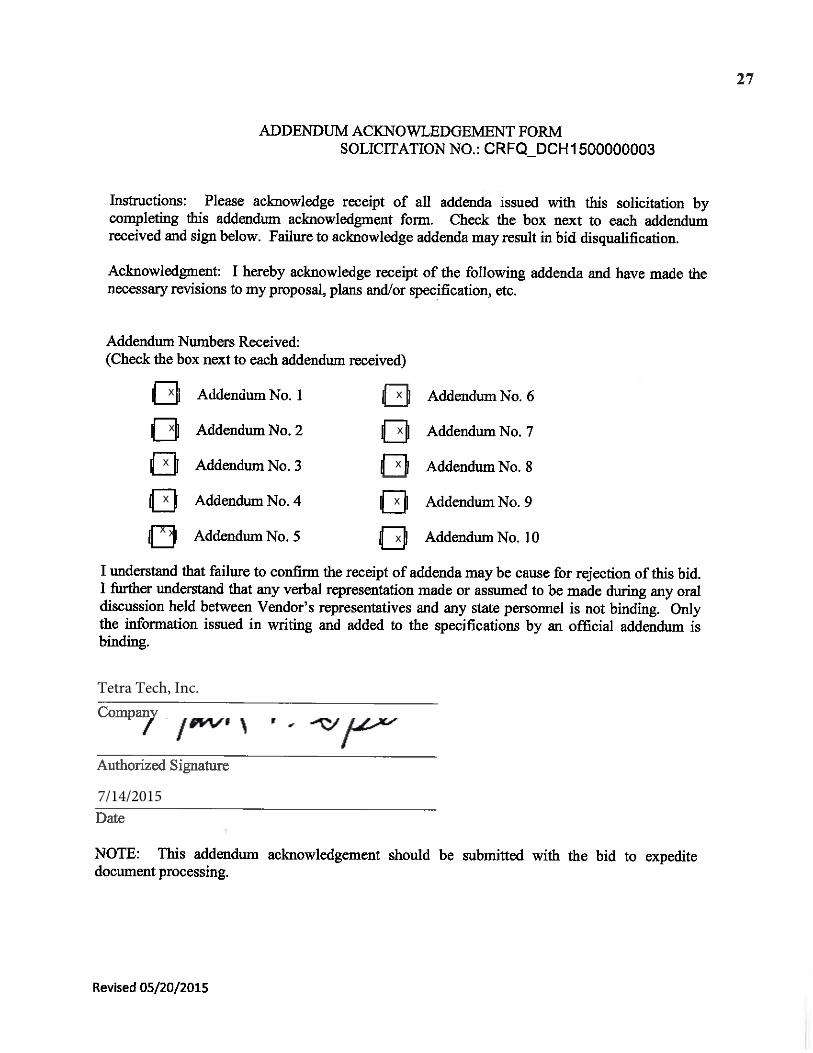
Section C: Addendum Acknowledgement
Tetra Tech, Inc.
7/14/2015
x
x
x
x
xx
x
x
x
x
x
mark.speranza
Mark Speranza Black
Section D: Personnel Resumes
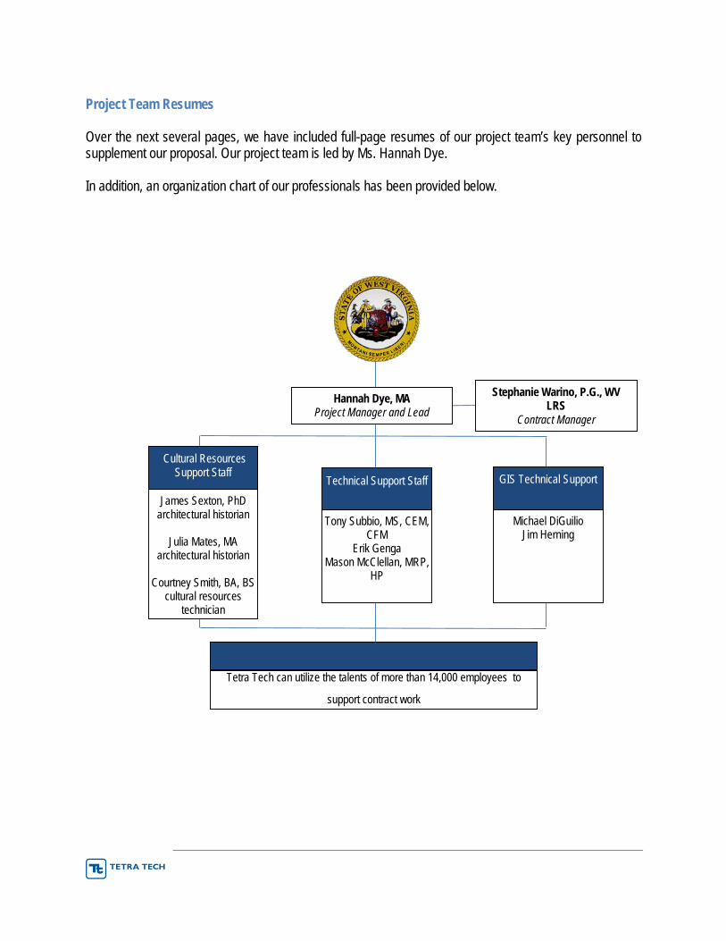
Project Team Resumes
Over the next several pages, we have included full-page resumes of our project team’s key personnel to supplement our proposal. Our project team is led by Ms. Hannah Dye.
In addition, an organization chart of our professionals has been provided below.
Stephanie Warino, P.G., WV LRS
Contract Manager
James Sexton, PhD architectural historian
Julia Mates, MA architectural historian
Courtney Smith, BA, BS cultural resources
technician
Cultural Resources Support Staff
Additional Support (as needed)
Tetra Tech can utilize the talents of more than 14,000 employees to
support contract work
Hannah Dye, MA Project Manager and Lead
Tony Subbio, MS, CEM, CFM
Erik Genga Mason McClellan, MRP,
HP
Technical Support Staff
Michael DiGuilio Jim Herning
GIS Technical Support
James Sexton, PhD Lead Architectural Historian Education
PhD, History of Art (American Architectural History), Yale University MA, History of Art, Yale University BA, History of Art, Yale University
Years of Experience: 24
Training/Certifications The Section 106 Essentials Course (ACHP, 2008). Historic Preservation and HUD Basics of a Part 58 Environmental Review for HUD-Assisted Projects Cultural Architectural Resource Management Archive (MHPC, 2010) Project Review (Section 106): Architectural Historian Continuing Education (NH DHR, 2009)
Dr. Sexton has 24 years of experience in the investigation and documentation of historic properties. He has an excellent understanding of the regulatory environment for above ground cultural resources and the necessary skills to perform survey and documentation studies.
He has provided technical expertise to clients with diverse needs in a variety of regulatory settings. Clients have included federal, state, and municipal agencies as well as cultural institutions and private interests; funding sources have included federal, state, and local programs. Areas of expertise include Section 106/Section 110 Reviews, National Historic Landmark/ National Register Nominations, Historic Architecture Surveys, Building Documentation, Local Historic Districts, Historic Structure Reports, and Mitigative Action Plans. Dr. Sexton served as an architectural historian for NEPA and Section 106 compliance documents for HUD as part of that agency’s response to Hurricane Sandy throughout the States of New York and New Jersey.
Dr. Sexton has served as the architectural historian on a number of diverse projects. His research has been used to establish the historical significance of buildings, structures, objects, and districts for a variety of different clients, including Superfund sites, current and former military installations, large-scale energy projects transmission lines, and gas pipelines located throughout the country.
Relevant Experience Historic Preservation Reviews for Hurricane Sandy Disaster Recovery Program, ProSource and New York State Homes and Community Renewal, NY, 2013-2014. Dr. Sexton served as an architectural historian for the Tier 2 reviews of historic-age properties that were slated to undergo rehabilitation, reimbursement, buyout, and acquisition but first needed to be reviewed to meet HUD’s Section 106 requirements. Dr. Sexton evaluated the project activities to determine if they met the allowances under the Programmatic Agreement of 2013 and evaluated properties for their eligibility for listing in the National Register of Historic Places. The properties were located in several New York counties, including Nassau County, Bronx County, Queens County, Broome County, and Schoharie County.
Historic Preservation Reviews for New Jersey’s CDBG-DR Grant Program, New Jersey Department of Environmental Protection, NJ, 2013 – present. Dr. Sexton serves as an architectural historian for historic preservation and Section 106 reviews prepared in support of disaster recovery programs in New Jersey funded by CDBG-DR grants awarded under the Disaster Relief Appropriations Act, 2013 (Pub. L. 113-2, enacted January 29, 2013) for Hurricane Sandy, Hurricane Irene, and Tropical Storm Lee. These reviews are being conducted in accordance with the HUD NEPA Regulations (24 CFR Parts 50 and 58).
Architectural Historian, Crown Cleaners Remediation Project, Herrings, NY, 2013. Dr. Sexton undertook fieldwork and prepared New York State Historic Resource Inventory form for a large abandoned paper mill complex as part of a Superfund Remediation Project. The subsequent report received concurrence of NY SHPO.
Davids’ Island/Fort Slocum Remediation Project, NY, 2010-2011. Dr. Sexton participated as part of team undertaking investigations to address Section 106 of the National Historic Preservation Act and provisions of the National Environmental Policy Act (NEPA). He worked on the preparation of an updated and complete historical architectural survey of the island, including inventory of over 100 identifiable structures. The documentation for this Project was performed to the standards of the Historic American Building Survey-Historic American Engineering Record (HABS/HAER) for key historic structures.
Arkwright Summit Wind Farm, Horizon Energy, Historic Architectural Resource Investigation, NY, 2008-2010. Dr. Sexton undertook research and fieldwork for a Historic Architectural Resource Investigation 5-mile Ring Area of Potential Effect Study in compliance with New York State Historic Preservation Office Guidelines for Wind Farm Development Cultural Resources Survey Work. The Tetra Tech team lead by Sexton surveyed more than 6,000 buildings and documented nearly 300 resources. Dr. Sexton researched and prepared a mitigation report for submission to lead agency. The documentation and mitigation reports both received concurrence of the New York State Historic Preservation Office.
Architectural Historian, Jericho Rise Wind Farm, Horizon Energy, NY, 2007-08. Dr. Sexton undertook research and fieldwork for a Historic Architectural Resource Investigation 5-mile Ring Area of Potential Effect Study in compliance with NY SHPO Guidelines for Wind Farm Development Cultural Resources Survey Work. The report documented 22 newly-identified resources and incorporated data from three previous studies. The work received concurrence of the NY SHPO.
Architectural Historian, WM Transmission Line Rebuild, Central Hudson Gas & Electric, NY, 2007-08. Dr. Sexton performed the research and fieldwork for a Historic Architectural Resource Investigation that includes a 1-mile Ring Area of Potential Effect Study. He surveyed and documented 90 resources and prepared report summarizing fieldwork, providing historical background, making recommendations on National Register eligibility, and assessing the potential impact of the proposed project. The report received concurrence of the NY SHPO.
Architectural Historian, CL Transmission Line Rebuild, Central Hudson Gas & Electric, NY, 2006-08. Dr. Sexton undertook research and fieldwork for a Historic Architectural Resource Investigation that includes a 1-mile Ring Area of Potential Effect Study. He surveyed and documented 22 resources and prepared report summarizing fieldwork, providing historical background, making recommendations on National Register eligibility, and assessing the potential impact of the proposed project. The report received concurrence of the NY SHPO.
Architectural Historian, Alabama Ledge Wind Farm, Horizon Energy, NY, 2006-2008. Dr. Sexton performed research and fieldwork for a Historic Architectural Resource Investigation 1-mile Ring Area of Potential Effect Study and a 5-mile Ring Area of Potential Effect Study in compliance with NY SHPO Guidelines for Wind Farm Development Cultural Resources Survey Work. The work surveyed and documented more than 450 resources. The subsequent report received concurrence of the NY SHPO.
MA, Public History, West Virginia University BA, Political Science, History Minor, West Virginia University
Years of Experience: 10
Training Section 106: The Essentials; NHPA American Battlefield Protection Program, NPS NRC Generic Environmental Impact Statement (GEIS) Training
Ms. Dye serves as a historian and architectural historian under the SOI’s Professional Qualification Standards (as defined in 36 CFR Part 61), according to the Federal historic preservation review process, and under Sections 106 & 110 of the National Historic Preservation Act of 1966 and Section 4(f) of the U.S. Department of Transportation Code. Ms. Dye exceeds the SOI’s Professional Qualification Standards for History and Architectural History (as defined in 36 CFR Part 61). She specializes in conducting historic resource surveys and archival research, and has extensive knowledge of the rules and regulations governing Section 106. She has conducted numerous large- and small scale cultural resource assessment surveys for various state and federal agencies, city departments, municipalities, and various organizations in both the public and private sectors.
Ms. Dye is adept at primary and secondary research, uncovering even the most obscure historical information to support architectural and historical studies to fully develop the historic contexts against which resources are evaluated. She brings practical experience with Section 106/NEPA compliance and completion of architectural/history surveys, proven success completing architectural descriptions and significance evaluations by applying the National Register of Historic Places criteria, and experience evaluating project effects on significant properties. Ms. Dye’s skills at collecting and interpreting historical documents, identification of historic architectural resources and interpretation of historic cultural landscape features contribute greatly to overall project efforts. She has completed numerous Historic Structure Reports, has successfully nominated properties to the National Register of Historic Places, and is proficient at performing deed and title searches.
Relevant Experience Historic Resource Survey for Phase I Cultural Resource Investigations, Mountain Valley Pipeline Project, EQT Midstream Partners, LP. West Virginia, 2014-2015. Ms. Dye served as lead architectural historian, performing the research and fieldwork for a historic architectural resource investigation that included a 188-mile-long (0.5-mile wide) Area of Potential Effect comprised of portions of Braxton, Doddridge, Fayette, Greenbrier, Harrison, Lewis, Monroe, Nicholas, Summers, Webster, and Wetzel Counties. She surveyed and documented approximately 250 resources and prepared report summarizing fieldwork, providing historical background, making recommendations on National Register eligibility, and assessing the potential impact of the proposed project.
Historic Resource Survey for Phase I Cultural Resource Investigations and Phase II National Register Evaluations, Appalachian Gateway Project and Burch Ridge Compressor Station Project, Dominion Transmission. West Virginia, 2009-2010. Ms. Dye served as architectural historian, performing the research and fieldwork for a historic architectural resource investigation that included a 19.2-mile-long (200-foot-wide) Area of Potential Effect for the pipeline corridor and a 0.25-mile radius Area of Potential Effect for the proposed Burch Ridge Compressor Station. The Area (s) of Potential Effect comprised portions of Barbour, Doddridge, Harrison, Kanawha, Marshall, and Wetzel Counties. She surveyed and documented six resources and prepared report summarizing fieldwork, providing historical background, making recommendations on National Register
eligibility, and assessing the potential impact of the proposed project. The subsequent report received concurrence of WVDCH. Historic Resource Survey for Phase I Cultural Resource Investigations and Criteria of Effects Assessment, West Virginia Segment 2, Mt. Storm Substation /502 Junction, Appalachian Trail Segments of the Trans-Allegheny Interstate Line Project, Power Engineers. West Virginia, 2007-2010. Ms. Dye served as architectural historian, performing the research and fieldwork for a historic architectural resource investigation that included a 73.2 mile-long (0.5-mile wide) Area of Potential Effect for a 500kV electric transmission line running roughly northwest to southeast across north-central West Virginia, (including 301 proposed tower locations) traversing portions of Grant, Tucker, Preston, Taylor, Marion, and Monongalia Counties. She surveyed and documented 30 resources and prepared report summarizing fieldwork, providing historical background, making recommendations on National Register eligibility, and assessing the potential impact of the proposed project. Ms. Dye also completed a Criteria of Effect Evaluation and Report on four NRHP-eligible resources. The subsequent reports received concurrence of WVDCH.
Historic Agricultural Resources Survey for Greene and Washington County, Pittsburgh History & Landmarks Foundation, Pennsylvania 2006-2007. Ms. Dye served as Principal Investigator for a reconnaissance level cultural resource survey of 1,150 historical agricultural sites in Greene and Washington Counties, Pennsylvania as part of the Pennsylvania Historical and Museum Commission’s (PHMC) larger Agricultural History Project. The project’s intent was to create a comprehensive resource that will support efforts to preserve working farms, develop heritage education and tourism, and raise awareness of Pennsylvania’s agricultural industry. An outcome of the project was a comprehensive website that addresses the scope and character of Pennsylvania’s agricultural resources.
Historic Resource Survey of the Murray Hill Neighborhood-Phase II, City of Jacksonville, Florida, 2009-2010. Ms. Dye served as principal investigator for a survey of 1,270 resources in the Murray Hill Neighborhood of Jacksonville, Florida. The survey was necessary to update information and to photo document previously surveyed architectural resources, as well as to provide new information on pre-1960 resources not previously surveyed. The Phase II Survey was intended to ensure that the City of Jacksonville’s preservation planning efforts effectively account for the entirety of its current resources. Information regarding previously and newly surveyed resources and recommendations for individual eligibility and as contributors to local and/or NRHP historic districts assisted the City in future preservation planning efforts.
Cultural Resources Constraints Identification and Mapping, Punxy Narrows Project, Pennsylvania Department of Transportation, District 10. Pennsylvania 2006-2007. Ms. Dye served as architectural historian, identifying and recording historic architectural resources as part of the creation of cultural resource constraint mapping. Prepared as a component of the broader-scope environmental constraints map, the cultural resources constraints map identified potential cultural limitations for the study area associated with the State Route (SR) 0119 (Section 590) Punxy Narrows corridor. The cultural resources constraints map depicted documentary background research, previously recorded and newly identified historic architectural and archaeological resources, and the potential for NRHP eligibility and/or further testing and evaluation. Information for each resource identified was presented in tabular form, with a single map showing the location for all resources.
Architectural Historian/Contributing Author. Integrated Cultural Resources Management Plan (ICRMP) Parks Reserve Forces Training Area, California in Alameda County, California.
Architectural Historian/Contributing Author. Cresheim Creek and Dam Alternative of the Wissahickon Creek Feasibility Study for the U.S. Army Corps of Engineers, Philadelphia District (USACE).
Architectural Historian/Contributing Author. Environmental Report and Integrated Cultural Resources Plan (ICRMP) for the LaSalle County Station NRC License Renewal Application (Cultural Resources Support) for Exelon Corporation LaSalle County, Illinois.
Senior Architectural Historian. Phase I Cultural Resources Survey, Appalachian Gateway TL-492 Extension 5 Pipeline Project, Franklin, Jefferson, and Morgan Townships, Greene County, Pennsylvania, for Dominion Transmission.
Senior Architectural Historian. Historic Resource Survey of the Murray Hill Neighborhood—Phase II, Duval County, Florida, for the City of Jacksonville Planning and Development Department.
Senior Architectural Historian. Letter Report, NHRP Evaluation and Criteria of Effects Assessment, Shippingport Atomic Power Station, Beaver County, Pennsylvania for FirstEnergy Nuclear Operating Company, Beaver Valley Power Station.
Architectural Historian. Historic architectural investigations for Millennium Pipeline’s Federal Energy Regulatory Commission (FERC) filing. FERC Certification, Permitting and GIS Data Services. Millennium Pipeline Company, L.P., Binghamton, New York, 2009.
Architectural Historian / Contributing Author. Phase I Cultural Resources Investigation, Wyoming Natural Gas Pipeline Project, Luzerne and Wyoming Counties, Pennsylvania, for Chief Gathering, LLC.
Senior Architectural Historian. Mitigation of NRHP-Eligible Architectural Resources, Documentation of Baltimore and Drum Point Railroad Mitigation Report, Calvert Cliffs 3 Nuclear Project, Calvert County, Maryland, for UniStar Nuclear Development, LLC.
Senior Architectural Historian. Phase I Cultural Resources Survey, Wilson Creek Wind Energy Project, Somerset County, Pennsylvania, for AES Wind.
Senior Architectural Historian. Phase Ib Management Summary, Archival Research, Bell Bend Nuclear Power Plant, Luzerne County, Pennsylvania, for Areva NP, Inc. and UniStar Nuclear Development, LLC.
Senior Architectural Historian. Phase I Cultural Resources Survey, PA-WV State-Line to 502 Junction (Segment 16) of the Trans-Allegheny Interstate Line (TrAIL) Project, Dunkard and Perry Townships, Greene County, Pennsylvania, for Power Engineers, Inc.
Senior Architectural Historian. Phase I Cultural Resources Survey, Appalachian Gateway TL-591 Project, Greene, Washington, Allegheny, and Westmoreland Counties, Pennsylvania, for Dominion Transmission.
Senior Architectural Historian. Background Research. Land Use History, Erie and Montezuma Wildlife Refuges, New York and Pennsylvania for the U.S. Fish and Wildlife Service.
Julia Mates Architectural Historian Education
MA, History/Public History, California State University BA, History, University of California
Years of Experience: 16
Additional Training/Certifications Historic Preservation and HUD (HUD training webinar) Basics of a Part 58 Environmental Review for HUD-Assisted Projects (HUD training webinar) Section 106: A Review for Experienced Practitioners (ACHP, May 2008) Identifying Historical Integrity (CPF, November 2008) Historian/Architectural Historian, California Historic Resource Information System
Ms. Mates has practiced the fields of history/architectural history and cultural resource management since 1999. Ms. Mates has served as a consulting historian on historical research investigations for federal, state and local governments. Her experience includes the inventory, recordation, and evaluation of historic resources using National Register of Historic Places and state historic resources guidelines of multiple states in the U.S. Her environmental planning experience includes preparing reports for and making recommendations to federal, state, municipal and private entities regarding National Historic Preservation Act Section 106 review and compliance, including consultation with various State Historic Preservation Officers. She has experience with Section 106 and the National Environmental Policy Act (NEPA). Ms. Mates served as an architectural historian for NEPA and Section 106 compliance documents for HUD as part of that agency’s response to Hurricane Sandy throughout the States of New York and New Jersey. She has served as a consulting historian, principal investigator, and resource author. Ms. Mates has contributed to planning and cultural resources management projects in New York, New Jersey, California, Oklahoma, Alaska, Nevada, Massachusetts, North Carolina, and Michigan. She has evaluated various types of historical resources for eligibility for national and state registers and has written numerous technical reports and compliance documents, such as historic survey reports, findings of effect, determinations of eligibility and Historic American Buildings Survey/Historic Architectural and Engineering Record documentation. Ms. Mates qualifies as a historian/architectural historian under the SOI’s Professional Qualification Standards (as defined in 36 CFR, Part 61).
Relevant Experience Historic Preservation Reviews for Hurricane Sandy Disaster Recovery Program, ProSource and New York State Homes and Community Renewal, New York, 2013-2014. Ms. Mates served as an architectural historian for the Tier 2 reviews of historic-age properties that were slated to undergo rehabilitation, reimbursement, buyout, and acquisition but first needed to be reviewed to meet HUD’s Section 106 requirements. Ms. Mates evaluated the project activities to determine if they met the allowances under the Programmatic Agreement of 2013 and evaluated properties for their eligibility for listing in the National Register of Historic Places. The properties were located in several New York counties, including Nassau County, Bronx County, Queens County, Broome County, and Schoharie County.
Historic Preservation Reviews for New Jersey’s CDBG-DR Grant Program, New Jersey Department of Environmental Protection, New Jersey, 2013 – present. Ms. Mates serves as an architectural historian for historic preservation and Section 106 reviews being prepared in support of disaster recovery programs in New Jersey funded by CDBG-DR grants awarded under the Disaster Relief Appropriations Act, 2013 (Pub. L. 113-2, enacted
January 29, 2013) for Hurricane Sandy, Hurricane Irene, and Tropical Storm Lee. These reviews are being conducted in accordance with the HUD NEPA Regulations (24 CFR Parts 50 and 58).
Preparation of United States Postal Service Postal Historic Structure Reports, Principal Historian, New York, Massachusetts, and California, 2012-2013. Tetra Tech was tasked by the United States Postal Service to conduct historic research and site documentation of more than 20 main post offices that the Postal Service was going to sell to private buyers. These historic properties were located in California, New York, and Massachusetts. Preparation of each of these reports included conducting a site visit and documenting historic features, completing Part 1 of the Historic Structures Report as outlined in National Register Brief 43: The Preparation and Use of Historic Structure Report, Documenting the Postal Service delineation of the Area of Potential Effect for future undertakings, preparing the California Department of Parks and Recreation Form 523A for the post office property; and developing a proposed List of Interested Parties. Ms. Mates conducted the fieldwork for all eleven post offices, conducted research, and coordinated with the Postal Service for these highly visible projects. Ms. Mates worked with the Tetra Tech historians to produce these eleven reports in a very short time frame.
Preparation of Integrated Cultural Resources Management Plan for Joint Base Fort Lewis McChord, Architectural Historian, 2012. The Integrated Cultural Resource Management Plan (ICRMP) synthesized and updated the 2004 McChord Air Force Base Cultural Resources Management Plan and the 2005 ICRMP for Fort Lewis into a comprehensive ICRMP for Joint Base Lewis McChord (JBLM), located in south-central Washington State. Ms. Mates updated the ICRMP with the most current information pertaining to historic properties and ensured that the ICRMP was consistent with Army Regulation 200-43 and Department of Defense Instruction 4715.3, and that the ICRMP is tailored to the specific requirements of what is now a joint base. The plan also presented updated goals and targets for cultural resource management that reference anticipated base project and mission needs.
Historic Properties Inventory, Portions of the Richmond Field Station, Principal Historian, 2012. This project entailed the inventory, recordation, and evaluation of 25 buildings on the Richmond Field Station to determine eligibility of the buildings for listing in the National Register of Historic Places. Many of the buildings date to the early twentieth century when the area was the California Cap Company.
Historical Resources Study for Buildings 46, 55, 63, and 64 at the Lawrence Berkeley National Laboratory, Principal Historian, 2012. This Historical Resources Study documented the evaluation of Buildings 46, 55, 63, and 64 at the Lawrence Berkeley National Laboratory for eligibility for listing in the National Register of Historic Places. Tetra Tech concluded that Buildings 46, 55, 63, and 64 are not eligible individually or as a historic district.
Mason McClellan Master of Community Planning, Historic Preservationist Education
MCP, City and Regional Planning, University of Pennsylvania Certificate in Historic Preservation, University of Pennsylvania BS, Anthropology, James Madison University
Years of Experience: 8
Mr. McClellan has managed and contributed to diverse land use and historic preservation planning projects, as well as redevelopment and growth planning initiatives. Mr. McClellan’s project work has included preservation and redevelopment strategies and plans, hazard mitigation plans, comprehensive plans, site and market analysis, economic impact analysis, housing assessments, public engagement, and disaster recovery planning.
Relevant Experience Community Resilience Planning Lead. Disaster recovery and resilience planning for several communities in New York State to address resilience following Hurricanes Sandy and Irene, and Tropical Storm Lee. Project work included an identification of vulnerable properties, including historic properties – some of which were damaged by storm events - community outreach, strategic visioning, risk assessment, housing and community needs assessments, HUD and CDBG compliance monitoring, critical infrastructure analysis, and project identification in support of an overarching resilience plan. In several communities, recovery and resilience planning was prioritized for several historic properties. Work was performed for the Governor’s Office of Storm Recovery, New York State.
Community Revitalization Planning Lead. Led the development of a comprehensive community revitalization and transit-oriented development plan and implementation strategy for the Borough of Chalfont. Worked with Borough officials to develop implementation strategies for priority projects, including the preservation and inclusion of an historic train depot in a broader community transit and tourism plan that included feasibility analysis, structuring of public-private partnerships, and public funding strategies.
Climate Change Economic Vulnerability Tool Lead. Mr. McClellan developed an economic vulnerability assessment tool for the State of Rhode Island that provided a guide and scaling methodology for local officials to identify potential threats and impacts to the local economy from climate change. He helped to develop the overall approach, methodology and assessment tool which will assist communities of varying scales and conditions in developing feasible action-oriented initiatives that respond to unique local threats from climate change. Project work included the development of a step-by-step guide for local planners to accurately identify potential threats from climate change, assess their impacts on economic assets and the overall local economy, and develop solutions to increase resilience.
TONY SUBBIO, CEM, CFM, PMP, MS EMERGENCY MANAGEMENT, TECHNICIAN Education
MS, Emergency Management, Millersville University, PA BS, Business Administration - Management, Millersville University, PA
Years of Experience: 11
As a Certified Emergency Manager, Certified Floodplain Manager, and Project Management Professional, Mr. Subbio has 11 years of professional experience in emergency management, with special expertise in emergency planning at the state-, region-, and county-levels. Mr. Subbio has led and contributed to projects, including all-hazards emergency operations planning, hazard mitigation planning, continuity of operations planning, public health emergency planning, and post-disaster community (long-term) recovery planning. He has developed, delivered, and evaluated Homeland Security Exercise & Evaluation (HSEEP)-compliant tabletop, functional, and full-scale exercises. Mr. Subbio has managed projects with budgets ranging from $8,000 to $1 million.
Relevant Experience Hazard Mitigation Planning
Fulton County, PA Hazard Mitigation Plan Update, 2014-2015. Mr. Subbio served as project manager to update the Fulton County, PA Hazard Mitigation Plan. He worked with the County’s Steering Committee, consisting of representatives of County, municipal, and private organizations within Fulton County to analyze the risks faced by the County, assess County and municipal capabilities, and update the County’s mitigation strategy.
Livingston County All Hazards Mitigation Plan Review and Upgrade, 2014-2015. Mr. Subbio served as project manager and lead planner to update the Livingston County Multi-Jurisdictional Hazard Mitigation Plan, and to upgrade it from addressing a few natural hazards to addressing natural and man-made hazards that may impact Livingston County and its towns and villages. Mr. Subbio worked with a core group of County and municipal stakeholders to guide the plan update. Mr. Subbio led Tetra Tech’s team of planners to work with representatives of 26 towns and villages to assess risks, analyze capabilities, and determine a mitigation strategy specific to each jurisdiction.
Hazard Mitigation Planning Support, 2011-Present. Mr. Subbio has served as a hazard mitigation planner on several projects. He collected information from local, state, and federal sources to profile hazards that may affect the following counties and their municipalities: • Westchester County, NY • Putnam County, NY • Montgomery County, NY • Chenango County, NY • Suffolk County, NY • Lehigh Valley (Lehigh and Northampton Counties, PA)
Westmoreland County, PA HMP Update, Westmoreland County Department of Public Safety, October 2013 – Present. Mr. Subbio managed the update of the Westmoreland County, PA HMP. He profiled natural and man-made hazards to which the County and its municipalities are vulnerable, worked with staff to form and meet with the County Hazard Mitigation Working Group, solicit municipal and public participation in the planning process, profile hazards, assist in developing a mitigation strategy and projects,
assess the county’s and municipalities’ capabilities, and draft the HMP itself. Mr. Subbio also mentored a staff member in project management, to facilitate her transition to that role on future projects.
Update of Six County-level Hazard Mitigation Plans on behalf of the Pennsylvania Emergency Management Agency, 2009-2011. Mr. Subbio managed and served as the lead planner on the update of six county-level hazard mitigation plans funded by the Pennsylvania Emergency Management Agency: Adams, Bedford, Cambria, Fulton, Lycoming, and Somerset. In each county, Mr. Subbio formed a Steering Committee, solicited municipal and public participation in the planning process, profiled hazards, assisted in developing a mitigation strategy and projects, assessed the county’s and municipalities’ capabilities, drafted the HMP itself, and secured PEMA and FEMA approval.
Community Recovery Planning
New York Rising Community Recovery Program, New York State Governor’s Office, 2013-2015. Mr. Subbio worked with local officials in the Village of Washingtonville in Orange County, NY, and the Town of Shandaken in Ulster County, NY, to assist in the local recovery from Hurricane Irene and Tropical Storm Lee in 2011. Mr. Subbio assisted the Village of Washingtonville in developing a scope and project description for a new combined facilities building that would house the justice courts, municipal offices, Department of Public Works, EMS, fire services, and police services, and to act as an emergency shelter and communications center for the Village of Washingtonville and the Town of Blooming Grove. He conducted similar work in the Town of Shandaken for a new multi-use municipal facility that would include the Town’s administrative offices, the police department, the Town Emergency Operations Center, the ambulance service, and garages for vehicles and large equipment; the facility could also be used as a regional evacuation site and as a community health and human services center.
In the second round of community planning, Mr. Subbio served as a technical advisor to the Project Manager, and assisted the Town of Blooming Grove, Town of Wallkill, and Town of Windham in identifying and describing community resilience projects.
Cumberland County Post-disaster Community Recovery Plan, Cumberland County (Pennsylvania) Planning Department, 2010-2011. On behalf of the Cumberland County Planning Department, Mr. Subbio served as Project Manager and Lead Planner to develop a Post-disaster Community Recovery Plan for Cumberland County and the three municipalities including and surrounding the Borough of Carlisle, the County Seat. Mr. Subbio conducted research into recovery planning, conducted stakeholder interviews with representatives from the local school districts, Dickinson College, the Carlisle Barracks (home of the U.S. Army War College), the Regional Chamber of Commerce, and other county departments to determine and document how the county and its municipalities would implement long-term recovery following a major disaster.
ERIC GENGA COMMUNITY PLANNER, TECHNICIAN
Education BS, University of Arizona
Certifications • Lead Safe Work Practices certification, Integrated Disbursement of Information System (IDIS)
training certificate through Pennsylvania Department of Community and Economic Development (DCED)
• New Jersey Council on Affordable Housing (COAH) Module I training for Municipal Housing Liaisons
• RCA Administrators, and Administrative Agents
• FEMA Introduction to Hazard Mitigation Certification
• FEMA Mitigation Planning for Local and Tribal Communities Certification Years of Experience: 15
Erik Genga is a community and regional planner with experience managing and contributing to diverse land use and community planning projects as well as redevelopment and growth planning initiatives specializing in providing community development consulting services. He has worked with multi-disciplinary teams of sub consultants in key project roles providing detailed community, site and market analysis, redevelopment strategies, economic impact analysis, public engagement, disaster recovery plans, implementation and funding strategies, creation of conceptual site plans, as well as technical plan development and public presentation. His work history includes assisting municipalities and counties with federal and state grant programs, including all phases of grant activity from application completion and submission to funding and compliance management. =He primarily worked with counties and municipalities to obtain and manage federal grant programs through the U.S. Department of Housing and Urban Development (HUD), including the Community Development Block Grant (CDBG) program and the HOME Investment Partnership program. In more than a decade of CDBG program experience. Mr. Genga has managed dozens of county and municipal clients throughout Pennsylvania and New Jersey. His comprehensive knowledge of the CDBG process includes:
• Application and Action Plan completion and submittal
• 5-Year Consolidated Plan development
• Verification of project eligibility, project prioritization and selection
• Service area identification and verification
• Contractor assistance and program education
• Environmental Review Record (ERR) management and completion
• Client liaison activity with HUD and DCED
• Comprehensive program compliance
• IDIS program management
• Project and program closeout
• Program and plan amendments and modifications
Mr Genga also worked on applications for the Neighborhood Stabilization Program and several grant programs provided through the Pennsylvania Department of Conservation and Natural Resources and PA Department of Community and Economic Development. In addition to managing federal and state grant
programs, Mr. Genga has also worked on development and planning projects throughout Pennsylvania, New Jersey, New York, Delaware, Virginia and West Virginia. These have included researching and writing land use analyses and condition reports, certifying areas as blighted under HUD guidelines, developing comprehensive plans for counties and municipalities, as well as fair housing studies in Delaware and Virginia. During his more than 14 years of community development work, he wrote and provided consultation on zoning ordinances and zoning issues for municipalities throughout Pennsylvania and West Virginia including the development of Stormwater Management ordinances for the City of Martinsburg and Jefferson County, West Virginia. Mr. Genga also conducted Section 8 housing inspections and provided work write-ups for municipal CDBG housing rehabilitation programs.
Relevant Experience Community Resiliency, Disaster Recovery Planning
Dauphin County, Community Development Block Grant – National Disaster Resilience Competition Mr. Genga is a lead member of the Dauphin County CDBG-NDR planning team. This included developing an extensive and highly competitive application for submittal to the U.S. Department of Housing and Urban Development (HUD) for federally declared disaster recovery and resilience projects and initiatives. The total potential funding award is $500 million and involved an extensive outreach and partnering process. Mr. Genga and the planning team developed the Phase 1 application for submittal to HUD and the Rockefeller Foundation for review and consideration. The application involved working with municipalities and stakeholders and identifying and quantifying remaining unmet needs from Tropical Storm Lee impacts. This resulted in identifying more than $200 million in remaining unmet need, primarily involving damaged infrastructure. The team then incorporated a flood and climate change assessment modeling system developed by Tetra Tech to be utilized across Dauphin County to identify the scale and area of future impacts. A methodology was then developed to “promote, protect, connect” the County in a comprehensive manner to not only protect form future flood disasters but to incorporate resilience, green initiatives, outreach/education, economic development, housing preservation and development, land use planning and stormwater management into a single planning initiative for the County.
Dauphin County, PA Community Development Block Grant-Disaster Recovery (CDBG-DR) Action Plan Mr. Genga assisted in the development of an Action Plan for the County to identify and address unmet community needs following Hurricane Irene and Tropical Storm Lee. Project work included identification and documentation of storm impacts, critical issues, and unmet recovery needs, and the development of strategies and programs to address those needs and create greater future resiliency. Mr. Genga also provided CDBG-DR programmatic guidance and compliance services and oversight of the project prioritization and selection process.
Stormwater Management Ordinance Development (Jefferson County and Martinsburg, WV) Mr. Genga worked with county and municipal staff to develop a comprehensive stormwater management ordinance that conformed to the West Virginia Department of Environmental Protection and the U.S. Environmental Protection Agency requirements, without inhibiting development potential within the County or community. Work included extensive research, public participation, and regulatory document review to ensure consistency.
MICHAEL DIGUILIO GIS TECHICIAN
Education BS, Environmental Planning and Design, Rutgers University-New Brunswick
Years of Experience: 2 Michael DiGiulio is a GIS Analyst and has provided community and hazard mapping support on a multitude of projects for jurisdictions in New Jersey, New York, and Pennsylvania. He has also provided support for and completed vulnerability assessments for these jurisdictions; this includes a hazard spatial analysis of population, building stock and critical facilities. Additional analysis is completed for the building stocks and critical facilities using a level 2 HAZUS analysis by updating the general building stock and critical facilities at the facility-level using the Comprehensive Data Management System.
Relevant Experience Local Mitigation Planning (DMA 2000). Mr. Diguilio provides support for the risk assessments and municipal annexes for all DMA 2000 hazard mitigation planning projects for county and single jurisdiction clients. He aids in data collection and conducts GIS and spatial analysis for identified hazards of concern, including flood, earthquake, wildfire, sea-level rise, and storm surge. In order to conduct the risk assessments, he generates a custom building stock using the most up-to-date tax data and parcels and complies a critical facilities inventory for the jurisdiction; both inventories are organized for compliance with the Comprehensive Data Management System (CDMS) and HAZUS-MH. Michael generates all community assets and hazard area maps for inclusion in each jurisdictional plan. In addition to mapping and risk assessment, he provides support with municipal plan review and writing municipal annexes.
Section E: Project Experience/References
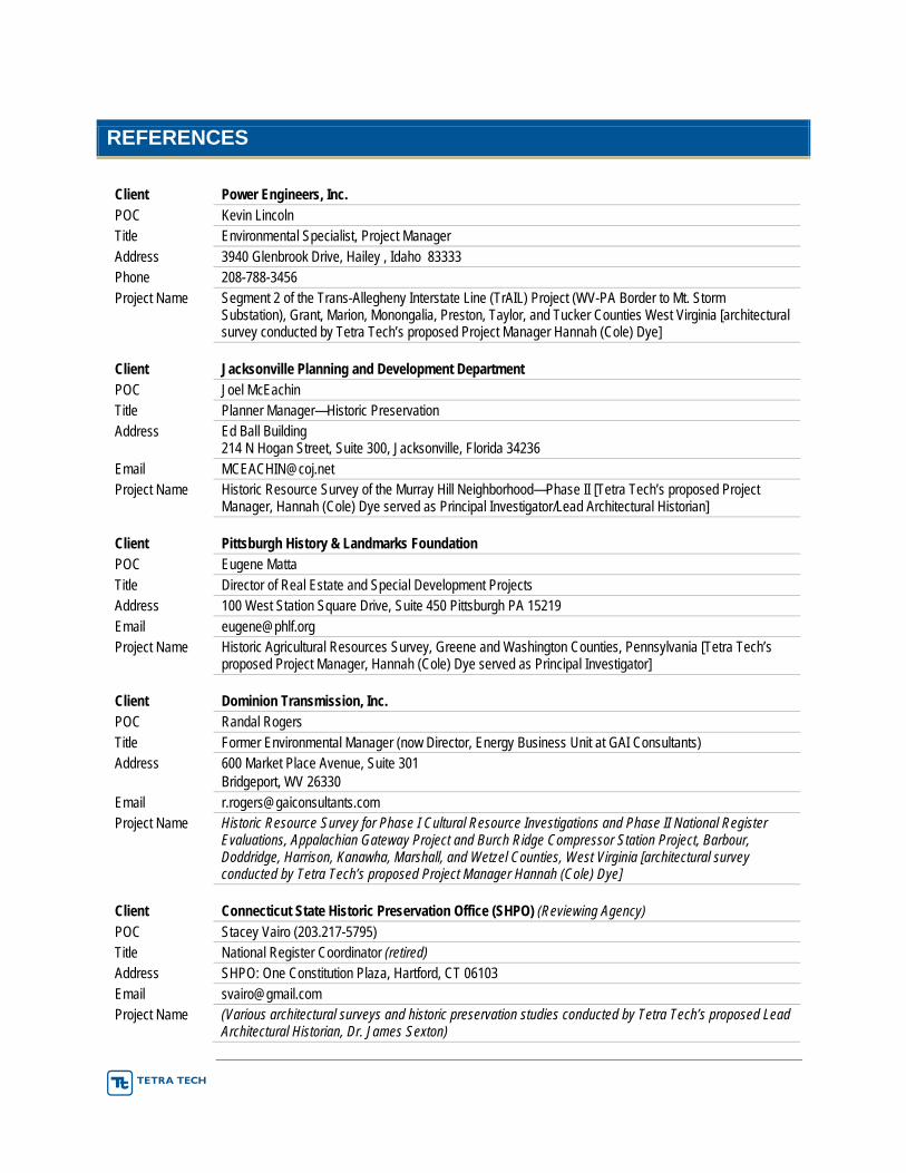
REFERENCES
Client Power Engineers, Inc. POC Kevin Lincoln Title Environmental Specialist, Project Manager Address 3940 Glenbrook Drive, Hailey , Idaho 83333 Phone 208-788-3456 Project Name Segment 2 of the Trans-Allegheny Interstate Line (TrAIL) Project (WV-PA Border to Mt. Storm
Substation), Grant, Marion, Monongalia, Preston, Taylor, and Tucker Counties West Virginia [architectural survey conducted by Tetra Tech’s proposed Project Manager Hannah (Cole) Dye]
Client Jacksonville Planning and Development Department POC Joel McEachin Title Planner Manager—Historic Preservation Address Ed Ball Building
214 N Hogan Street, Suite 300, Jacksonville, Florida 34236 Email [email protected] Project Name Historic Resource Survey of the Murray Hill Neighborhood—Phase II [Tetra Tech’s proposed Project
Manager, Hannah (Cole) Dye served as Principal Investigator/Lead Architectural Historian]
Client Pittsburgh History & Landmarks Foundation POC Eugene Matta Title Director of Real Estate and Special Development Projects Address 100 West Station Square Drive, Suite 450 Pittsburgh PA 15219 Email [email protected] Project Name Historic Agricultural Resources Survey, Greene and Washington Counties, Pennsylvania [Tetra Tech’s
proposed Project Manager, Hannah (Cole) Dye served as Principal Investigator]
Client Dominion Transmission, Inc. POC Randal Rogers Title Former Environmental Manager (now Director, Energy Business Unit at GAI Consultants) Address 600 Market Place Avenue, Suite 301
Bridgeport, WV 26330 Email [email protected] Project Name Historic Resource Survey for Phase I Cultural Resource Investigations and Phase II National Register
Evaluations, Appalachian Gateway Project and Burch Ridge Compressor Station Project, Barbour, Doddridge, Harrison, Kanawha, Marshall, and Wetzel Counties, West Virginia [architectural survey conducted by Tetra Tech’s proposed Project Manager Hannah (Cole) Dye]
Client Connecticut State Historic Preservation Office (SHPO) (Reviewing Agency) POC Stacey Vairo (203.217-5795) Title National Register Coordinator (retired) Address SHPO: One Constitution Plaza, Hartford, CT 06103 Email [email protected] Project Name (Various architectural surveys and historic preservation studies conducted by Tetra Tech’s proposed Lead
Architectural Historian, Dr. James Sexton)
ARCHITECTURAL AND HISTORICAL RESOURCES SURVEY FOR MOUNTAIN VALLEY PIPELINE Project Location: West Virginia
Year Completed: 2014-present
Dollar value of services provided: Approximately $10M for all environmental and cultural resources assignments to date, including more than $6M for cultural resources.
Project Description: In 2015, Tetra Tech conducted an architectural and historical resources survey and a Phase I archaeological survey for Mountain Valley Pipeline LLC., (MVP). MVP, a joint venture between affiliates of EQT Corporation, NextEra Energy, Inc., WGL Holdings, Inc. and Vega Energy Partners, Ltd., is seeking a Certificate of Public Convenience and Necessity from the Federal Energy Regulatory Commission (FERC) pursuant to Section 7(c) of the Natural Gas Act authorizing it to construct and operate the proposed Mountain Valley Pipeline Project (Project) located in 16 counties in West Virginia and Virginia. MVP plans to construct an approximately 294.1-mile, 42-inch-diameter natural gas pipeline to provide timely, cost-effective access to the growing demand for natural gas for use by local distribution companies, industrial users and power generation in the Mid-Atlantic and southeastern markets, as well as potential markets in the Appalachian region. Approximately 195 miles of the 294.1-mile pipeline would be constructed in West Virginia. The pipeline is designed to transport up to 2.0 billion cubic feet per day of natural gas and would require approximately 217,200 horsepower of compression at three compressor stations, one in Wetzel, Braxton, and Fayette Counties, as well as measurement, regulation, and other ancillary facilities along the route that are required for the safe operation of the pipeline.
Tetra Tech’s architectural and historical resources survey resulted in the reconnaissance-level survey of approximately 250 resources in the MVP Project APE. The architectural and historical resources surveyed by Tetra tech were evaluated for their significance according to NRHP Criteria, the historic context prepared for the project, and applicable National Register guidelines. In evaluating the surveyed resources, both the historical significance and architectural integrity of each was assessed, utilizing the seven aspects of integrity as recognized by the National Register.
HISTORIC PRESERVATION REVIEWS FOR NEW JERSEY’S COMMUNITY BLOCK DEVELOPMENT GRANT-DISASTER RELIEF (CDBG-DR) GRANT PROGRAM Project Location: New Jersey
Year Completed: 2013-present
Dollar value of services provided: Approximately $2.1M for all environmental and cultural resources assignments to date, including more than $300K for cultural resources.
Project Description: Tetra Tech prepares historic preservation and Section 106 reviews to support disaster recovery programs in New Jersey, funded by CDBG-DR grants awarded under the Disaster Relief Appropriations Act, 2013 for Hurricane Sandy, Hurricane Irene, and Tropical Storm Lee. These reviews are conducted in accordance with the NEPA Regulations (24 CFR Parts 50 and 58) for grant applications for funds originating with the U.S. Department of Housing and Urban Development (HUD) to repair and enhance properties damaged by recent catastrophic weather events.
Scope of Work: To date, the team has conducted initial screening reviews of more than 1,400 applications to determine whether historic preservation Programmatic Agreement allowances apply or whether consultation with the New Jersey Historic Preservation Office is needed. SOI-qualified specialists in
architectural history and archaeology prepare and submit SHPO consultation packages that consist of a statement of the Undertaking, property description (including, as appropriate, brief property histories), and Assessment of Effects, supported by maps and current field photographs of the properties taken by Tetra Tech field personnel.
Client type: New Jersey Department of Environmental Protection
Approximate acreage of project area: 350 acres distributed among nine counties
Approximate number of historic properties inventoried: 1,400
Approach to evaluating properties for potential NRHP eligibility: Tetra Tech relies on a combination of field inspections and documentation undertaken from the public right-of-way, supplemented by desktop research, to assess the ways in which the observed properties meet the NRHP Criteria and whether they retain sufficient integrity to be recommended as potentially eligible to the NRHP, or in the case of previously identified resources, whether they retain sufficient integrity to still be considered NRHP-eligible. For properties newly or previously identified as eligible, Tetra Tech undertakes an assessment of effect for the proposed work.
Involvement and coordination with any federal, state agencies, and/or local governments: Tetra Tech’s client on this project is the New Jersey Department of Environmental Protection while the work products are submitted to the New Jersey Historic Preservation Office. This arrangement has Tetra Tech working in close consultation with both state agencies.
Data collection tools used in the field: Digital cameras, smart phones, and mini-tablets.
Explanation of how the personnel met deadlines for the project: Tetra Tech has met the deadlines on this project through a variety of means. Tetra Tech began this ongoing assignment with a significant planning effort, so that we could try to anticipate and prepare for the work, rather than simply react to the work as it is assigned. We dispatch field personnel to undertake documentation as soon after assignments are received as is feasible; this is frequently the next business day. (The work is assigned to contractors, including Tetra Tech, in weekly allotments.) As the number of resources to be reviewed varies, Tetra Tech has made sure that sufficient qualified personnel are available at all times to handle the volume of work in a timely manner. Tetra Tech has created, and refined, in-house procedures that have improved our efficiency over the length of the assignment.
TOOKANY CREEK FLOOD RISK MANAGEMENT FEASIBILITY STUDY CULTURAL RESOURCES INVESTIGATIONS Project Location: Cheltenham Township, Montgomery County, Pennsylvania
Year Completed: 2014
Dollar value of services provided: Approximately $35,000
Project Description: Tetra Tech conducted an historic resource study to aid in the selection, design, and construction of the best alternative for flood risk management for residential and commercial/industrial structures in Cheltenham Township, Montgomery County, Pennsylvania. Both architectural and archaeological resources were surveyed as part of this effort.
The study area focused on flood prone areas throughout Cheltenham Township, Montgomery County. Cheltenham is part of the first ring of suburban development outside of the City of Philadelphia and is largely at maximum development capacity. Tookany Creek itself is an urbanized tributary of Tacony Creek in the Tacony-Frankford Creek watershed and is ultimately part of the Delaware River drainage system. In
Cheltenham Township, Tookany Creek is 98% open channel flowing through residential and parklands for more than 95% of its length.
Scope of Work: Tetra Tech’s cultural resources staff undertook a three-part process: 1) archival and documentary research; 2) a site visit to conduct pedestrian survey of the proposed detention basin alternatives and associated historic resources; and 3) preparation of a technical report of findings which would include recommendations for further work.
Client type: U.S. Army Corps of Engineers, Philadelphia District
Approximate acreage of project area: 450 acres distributed among eleven sites
Approximate number of historic properties reviewed: 750
Approach to evaluating properties for potential NRHP eligibility: Tetra Tech relied on a combination of field inspections and documentation undertaken from the public right-of-way, supplemented by desktop research, to assess the ways in which the observed properties meet the NRHP Criteria and whether they retain sufficient integrity to be recommended as potentially eligible to the NRHP, or in the case of previously identified resources, whether they retain sufficient integrity to still be considered NRHP-eligible. Tetra Tech also assessed the potential for the neighborhoods surrounding each detention basin to qualify as a National Register Historic District.
Involvement and coordination with any federal, state agencies and/or local governments: Tetra Tech’s client on this project was the U.S. Army Corps of Engineers, Philadelphia District office. Work was undertaken and reports were prepared based on discussion with the agency’s cultural resources staff.
Data collection tools used in the field: Digital camera outfitted with a hotshoe mounted geotagger and Trimble GPS units.
Explanation of how the personnel met deadlines for the project: Tetra Tech met the deadlines on this project through a variety of means. Significant efforts went into planning prior to fieldwork, using GIS tools, desktop research, and files searches (both on-line, through Pennsylvania’s Cultural Resources Geographic Information System (CRGIS), and in-person at the PHMC-BHP offices) to fully prepare the field crews for what might be encountered during the survey. Once in the field, the use of GPS equipment kept the surveyors in the Area of Potential Effect, while the use of geotagging equipment streamlined the identification of photos. Once the report process was begun, the archaeologist, architectural historian, and GIS analyst worked closely to provide the required report in a timely manner.
HISTORIC ARCHITECTURAL/AGRICULTURAL SURVEY, PITTSBURGH HISTORY & LANDMARKS FOUNDATION (PHLF) Project Location: Greene and Washington Counties, Pennsylvania
Year Completed: 2008
Project Description and Scope: The Pennsylvania Agricultural History Project involved a unique partnership among the PHMC, the Pennsylvania Department of Transportation (PennDOT), and the Pennsylvania State University with funding from the Federal Highway Administration and the federal Preserve America program. Its intent was to create a comprehensive resource that will support efforts to preserve working farms, develop heritage education and tourism, and raise awareness of Pennsylvania’s agricultural industry. An outcome of the project is a comprehensive website that addresses the scope and character of Pennsylvania’s agricultural resources.
Members of Tetra Tech’s cultural resources staff completed the historic agricultural field survey for the Greene and Washington County portions of this larger project. From July 2007 through March 2008, the field survey team was in Washington and Greene Counties, conducting a reconnaissance level survey of the farms and landscapes of this region.
The survey area, located in southwestern Pennsylvania, encompassed approximately 917,120 acres. The area was bounded by Beaver and Allegheny Counties to the north, the Monongahela River to the east, and West Virginia to the south and west. It is generally rural with somewhat rugged topography. Greene County, for example, is 89% rural. The area’s total population consists of a scant 243,569 people. Within the area, there are approximately 3,387 active farmsteads, most of which are 50 years or older. 2,506 of these are located in Washington County, while the remaining 881 are located in Greene County. Approximately 153 agricultural resources within the area were previously inventoried; 16 of these properties are listed on the NRHP.
The field survey team conducted a historic agricultural reconnaissance level survey of 1,150 properties 50 years or older located within the survey area. Seven hundred fifty (750) surveys were completed in Washington County, while the remaining 400 were completed in Greene County. Priority was given to sites that were active agricultural sites with historic buildings, non-active farms with intact historic farmstead structures, non-active farms with no associated fields that still contained historic agricultural structures, and farms under developmental pressures.
To achieve a representative example of agricultural sites in the survey area, 23 surveys were completed for each township in Washington County, while 20 were completed for each township in Greene County. These numbers were attained by dividing the number of total surveys to be completed in the county by the number of townships in the county. In the event that a township was lacking in historic agricultural resources, extra surveys were completed in townships that were rich in historic agricultural resources.
The field survey began in the northwest corner of Washington County. The survey team worked from the west to the east north of Interstate (I)-70 and then in the opposite direction, east to west, south of I-70. In Greene County, the western portion was surveyed first followed by the north and eastern areas of the county. The survey concluded with a two-township area in the south-central part of the county.
All field survey documentation was captured in a Microsoft Access database created by and provided to the field survey team by PHMC-BHP. The database contained data fields corresponding to those on the HRSF and the supplemental farmstead form. All components of the field survey documentation, including GPS locations (UTMs), photographs (field, historic, aerial), photo logs, and sketch maps were incorporated into the database.
Client type: The Pennsylvania Agricultural History Project involved a unique partnership among the PHMC, PennDOT, and the Pennsylvania State University with funding from the Federal Highway Administration and the federal Preserve America program.
Approximate acreage of project area: 917,120 acres
Approximate number of historic properties reviewed: 1,150 historical agricultural sites in Greene and Washington Counties, Pennsylvania
Historic Resource Survey for Phase I Cultural Resource Investigations and Phase II National Register Evaluations, Appalachian Gateway Project and Burch Ridge Compressor Station Project, Dominion Transmission. West Virginia Project Location: Barbour, Doddridge, Harrison, Kanawha, Marshall, & Wetzel Counties, West Virginia
Year Completed: 2010
Project Description and Scope: Between January and December 2009, members of Tetra Tech cultural resources staff conducted Phase I cultural resource investigations of the Appalachian Gateway Project, including background research, a Phase Ia archaeological reconnaissance, a Phase Ib archaeological field survey, and an architectural survey. Following initial correspondence with the WVDCH, the following proposed facilities were determined to have no potential to impact cultural resources within the APE: Chelyan, Lewis-Wetzel, Pepper, and Schutte compressor stations and the proposed TL-570 pipeline (see Appendix A). Thus, an architectural and historical survey of the proposed Appalachian Gateway Burch Ridge compressor station and TL-590 pipeline project areas (Marshall County) in April 2009.
This study was performed by Tetra Tech architectural historian Hannah L. Dye, M.A. according to Archaeology and Preservation: Secretary of the Interior’s Standards and Guidelines (48 FR 44716-44716-44742); National Register Bulletin 15-How to Apply the National Register Criteria for Evaluation (National Park Service 1998); and National Register Bulletin 21-Defining Boundaries for National Register Properties (National Park Service 1997), as well as applicable state guidelines for survey projects. Fieldwork was conducted for six resources, consisting of the compilation of digital photographs of resources and evaluations of their NRHP eligibility according to NRHP criteria for significance and standards of integrity. Pursuant to WVDCH guidelines, these resources, including primary buildings and any contributing outbuildings, were digitally photographed and recorded on West Virginia Historic Property Inventory (HPI) forms. The architectural style, condition, and important features of each resource was recorded and major changes or alterations were noted. In the evaluation of these resources, the architectural integrity of each was assessed. Within the concept of integrity, the NRHP Criteria recognize seven aspects that, in various quantities, define integrity: location, design, setting, materials, workmanship, feeling, and association.
CULTURAL RESOURCES CONSTRAINTS IDENTIFICATION AND MAPPING, PUNXY NARROWS PROJECT, JEFFERSON COUNTY, PENNSYLVANIA Client: Pennsylvania Department of Transportation, District 10
Project Location: Jefferson County, Pennsylvania
Year Completed: 2009
Project Description and Scope Prepared as a component of the broader-scope environmental constraints map, the cultural resources constraints map identified potential cultural limitations for the study area associated with the State Route (SR) 0119 (Section 590) Punxy Narrows corridor. The cultural resources constraints map depicted documentary background research, previously recorded and newly identified historic architectural and archaeological resources, and the potential for NRHP eligibility and/or further testing and evaluation. Information for each resource identified is presented in tabular form, with a single map showing the location for all resources.
The cultural resources constraint map preparation initiated with a review of previously documented historic properties within the study corridor defined as the area between the intersection of Jenks Avenue and SR
0119 and the Big Run Bridge in Big Run confined by Mahoning Creek. This involved an analysis of entries in the PHMC-BHP’s CRGIS database, as well as an assessment of previous Pennsylvania Archaeological Site Survey (PASS) and PHRS documents at PHMC-BHP in Harrisburg. These sources proved useful in determining the presence of previously documented archaeological and historic architectural resources and in predicting potential for unrecorded culturally sensitive areas.
NHPA SECTION 106 HISTORIC PROPERTIES IDENTIFICATION, ASSESSMENT, AND MITIGATION ACTIVITIES, DEMOLITION AND SITE RESTORATION, FORMER FORT SLOCUM, DAVIDS’ ISLAND, NEW ROCHELLE, NY Project Location: Westchester County, NY
Year Completed: 2010
Dollar value of services provided: All services: $25M All cultural resources assignments: ≈$1.25M
Project Description: Under contract to the U.S. Army Corps of Engineers—New York District, Tetra Tech completed a six-year project whose ultimate goal was to demolish the ruins of Fort Slocum, a post of the U.S. Army that closed in 1965, to facilitate future redevelopment of Davids’ Island, where the post had been located. Tetra Tech was responsible for all aspects of the project, including environmental investigations and remedial action activities, demolition of the installation, and post-demolition site restoration. In addition, to completing demolition, Tetra Tech prepared a wide variety of studies, reports, and other documentation to comply with NEPA, the NHPA, and numerous other federal, state, and local statutes and regulations.
Scope of Work: Throughout the project, Tetra Tech supported the U.S. Army Corps of Engineers in achieving compliance with Sections 106 and 110 of the NHPA and applicable regulations, including 36 CFR 800. With the concurrence of the New York State Historic Preservation Officer, the U.S. Army Corps of Engineers determined that Fort Slocum was eligible for the NRHP as a historic district formally known as the Fort Slocum Historic and Archaeological District. Using in part information assembled by Tetra Tech, the U.S. Army Corps of Engineers entered into a MOA with the SHPO and local governments to address the loss of the historic district due to demolition. Tetra Tech’s assignments related to cultural resources at the former installation included:
Development of an updated architectural inventory for the facility;
Phase I archaeological survey;
Alternatives analysis to ascertain whether any preservation of selected elements of the facility would be cost-effective and viable alternatives to demolition;
Documentation of 90 individual buildings and structures identified as contributing resources of the historic district to the standards of the HABS/HAER;
Oral history of Fort Slocum, involving several different classes of people associated with it, including Army personnel, civilian workers, and family members resident at the installation;
Video documentation of Davids’ Island prior to demolition of the ruins and of the demolition process;
Historic landscape survey, focusing on small-scale furnishings such as fire hydrants and benches and assessing the extent to which historic plantings persist to the present;
Stakeholder consultations;
Public outreach, including an extensive, award-winning website on the history, archaeology, and historic architecture of Fort Slocum, “The Army’s Century on Davids’ Island” (http://Davids’island.westchesterarchives.com);
Organization and transfer of research records and data, including 8,000 image files and other records comprising the project’s digital repository of research materials, to the New Rochelle Public Library.
For present purposes, the most important assignment was the preparation of documentation sets to HABS/HAER standards for the 90 contributing elements of the Fort Slocum historic district, including buildings, structures, and objects. This assignment involved development of an 80-page historic context of the installation and preparation of documentation for individual resources, which included descriptions, discussion of historical use and alteration, existing conditions photographs, and historic plans, maps, and photographs. The resulting documentation amounted to six volumes of loose-leaf binders and is also available from the project website (http://Davids’island.westchesterarchives.com [Archive > Downloads]). It was accepted by the U.S. Army Corps of Engineers and the SHPO.
Client type: Federal (U.S. Army Corps of Engineers)
Approximate acreage of project area: 78 acres
Approximate number of historic properties inventoried: Approximately 113 buildings, structures, objects, and major landscape features were documented during the reconnaissance-level survey, of which 90 were intensively documented as part of a mitigation activity specified by the MOA. The historic landscape survey identified and mapped 174 small-scale cultural features and 323 examples of historic vegetation.
Approach to evaluating properties for potential National Register of Historic Places eligibility: Fort Slocum was originally evaluated as a historic district determined to be potentially eligible for the NRHP during studies performed by others in the late 1980s. When Tetra Tech began working with the U.S. Army Corps of Engineers in 2004, the goal of architectural inventory was to reassess this finding and to provide a current inventory of contributing resources with documentation of condition. By the 2000s, the former installation was severely deteriorated, and it was therefore logically considered as a historic district, conceptualized as a significant assemblage of buildings and other elements linked by historical continuities but now generally lacking individual distinctiveness because of 40 years of neglect, deterioration, and vandalism. Indeed, because some of the constituent elements were in an advanced state of ruin, and because of the potential for archaeological resources related to the development of the facility prior to the existing assemblage of buildings and structures, the district was presented as a historic and archaeological district. Evaluation and documentation of the NRHP eligibility of the installation was thus an iterative process, in which prior administrative decisions, current field inventory, and fresh historical research were successively considered to establish the historical significance of the property and its eligibility under Criteria C (design/construction) and A (historical events).
Involvement and coordination with any federal, state agencies and/or local governments: Project client was a federal agency (U.S. Army Corps of Engineers). Most consultation with the SHPO and the Advisory Council for Historic Preservation was conducted directly by the client. However, Tetra Tech occasionally met with or contacted the SHPO to address technical issues related to various project assignments. Tetra Tech met regularly with representatives of the U.S. Army Corps of Engineers , the city of New Rochelle, Westchester County (including the County Executive and the county legislature), and the local member of Congress to review progress, including matters related to historic preservation. In addition, Tetra Tech worked with stakeholders and others with an interest in and knowledge of the history and significance of Fort Slocum, including the city historian, the staff of the county archives, and a historical group devoted to the documentation of the installation (Friends of Fort Slocum).
Data collection tools used in the field: Field data was collected with a range of tools, including paper and pens/pencils, standardized paper forms, digital cameras, and GPS units with submeter accuracy.
Explanation of how the personnel met deadlines for the project: The project was divided into a number of separate assignments or task orders, each with its own schedule and deadlines. Deadlines were established in consultation with the client and in consideration of the concerns of various stakeholders. Daily reports of field activities and monthly summary reports were submitted to the client. Formal and informal meetings and communications both internally and between Tetra Tech and the client ensured all project operations were completed in a timely manner.
GENESSEE COUNTY, NY - ALABAMA LEDGE WIND FARM Project Location: Alabama, Genesee County, NY
Year Completed: 2013
Dollar value of services provided: $1M
Project Description: Alabama Ledge Wind Farm proposed constructing a wind-powered electric generating facility comprising approximately 40 wind turbine generators with a combined capacity of 80 megawatts. Tetra Tech performed environmental, engineering, and other studies to support the development of the Project.
Scope of Work: Tetra Tech undertook a survey of above-ground historic resources within five miles of the nearest project element and that fell within computer-modelled areas of visibility for the project. As required by the New York State Historic Preservation Office Guidelines for Wind Farm Development Cultural Resources Work, this was the second phase of work on this Project. The initial phase of work, a survey within 1 mile of the project, was undertaken to build the SHPO’s confidence in Tetra Tech’s approach to the assessment of historic properties. (In subsequent wind farm projects in New York State, Tetra Tech was allowed to skip this preliminary step.) The second phase of work incorporated lessons from the initial phase and recorded only those properties determined in the field to be potentially eligible to the NRHP. The findings were presented to the NY SHPO in a report summarizing the findings and documenting the identified resources. We received concurrence from the NY SHPO.
Client type: Private Developer
Approximate acreage of project area: 88,311
Approximate number of historic properties inventoried: 440
Approach to evaluating properties for potential NRHP eligibility: Tetra Tech relied on field inspections undertaken from the public right-of-way to assess the ways in which the observed properties met the NRHP Criteria and whether they retained sufficient integrity to be recommended as potentially eligible to the NRHP. With the approval of the SHPO, only those property determined to be potentially eligible to the NRHP were inventoried.
Involvement and coordination with any federal, state agencies and/or local governments: Tetra Tech submitted this report to the U.S. Army Corps of Engineers, the lead Federal Agency on the Project. In addition, we worked closely NY SHPO to meet their requirements and to work within Section 106 of the National Historic Preservation Act of 1966. Data collection tools used in the field: Digital SLR cameras and hand-held GPS units with a custom data dictionary were used in the field to collect pertinent data about the recorded buildings.
Explanation of how the personnel met deadlines for the project: Tetra Tech undertook extensive pre-survey planning to insure that lessons learned from the initial phase of survey were incorporated into this phase. In addition, Tetra Tech used hand-held GPS units with custom data dictionaries to streamline data collection in the field. Finally, Tetra Tech worked diligently to communicate frequently both internally among the team members and project manager and with the client and regulatory agencies.
Section E: Contract Manager Form
Stephanie Warino1000 Green River DriveFairmont, WV [email protected]