50

Western Area Power Administration U.S. Department of Energy
Type A Accident Investigation Report
Vehicle Fatality Accident, July 1, 2008 59 th Avenue NE and Highway 117 West of Cando, North Dakota
August 2008

Disclaimer
This report is an independent product of the Type A Accident Investigation Board (Board) appointed by Anthony H. Montoya, Chief Operating Officer, Office of the Chief Operating Officer, Western Area Power Administration.
The Board was appointed to perform a Type A Investigation of this accident and to prepare an investigation report in accordance with DOE Order 225.1A, Accident Investigations.
The discussion of facts, as determined by the Board, and the views expressed in the report do not assume and are not intended to establish the existence of any duty at law on the part of the U.S. Government, its employees or agents, contractors, their employees or agents, or subcontractors at any tier, or any other party.
This report neither determines nor implies liability.


Table of Contents
Acronyms and Definitions ....................................................................................... iii Executive Summary ................................................................................................ iv
1.0 Introduction 1.1 Background .............................................................................................1 1.2 Accident Site Description ........................................................................1 1.3 Scope, Purpose, Conduct and Methodology ...........................................1
1.3.1 Scope ........................................................................................2 1.3.2 Purpose .....................................................................................2 1.3.3 Conduct .....................................................................................2 1.3.4 Methodology..............................................................................3
2.0 Accident Facts and Analysis 2.1 Accident Description and Chronology .....................................................4
2.1.1 Background and Accident Description.......................................4 2.1.2 Chronology of Events ................................................................4
2.1.2.1 PreCrash Events Description......................................4 2.1.2.2 Crash Events Description ............................................5 2.1.2.3 PostCrash Events Description ....................................5
2.2 Accident Response.......................................................................6 2.3 Accident Notifications and Team Formation .................................6 2.4 Ancillary Issues.............................................................................7
3.0 Analysis 3.1 Events and Causal Events ......................................................................8 3.2 Barrier Analysis .......................................................................................8 3.3 Safe Start Program Analysis ...................................................................8 3.4 Speed and Stopping Distance Analysis...................................................8 3.5 Casual Factors ........................................................................................9
4.0Conclusions and Judgments of Need...............................................................10
5.0Board Signatures..............................................................................................11
6.0Board Members and Support Staff ...................................................................12

Appendix A Appointment of Type A Accident Investigation Board.................... A1 Appendix B Barriers Analysis Summary ........................................................... B1 Appendix C
Events and Causal Factors Chart, page 1.............................................. C1 Events and Causal Factors Chart, page 2.............................................. C2
Appendix D Stopping Distance Chart and Explanation.............................................. D1 Stopping Distance Graph and factors .................................................... D2
Appendix E Reference List ............................................................................... E1 Appendix F Figures
Figure 1 GIS Location map of 59 th Avenue NE and Highway 17 ................F1 Figure 2 GIS Area map of North Dakota – Route of workday.....................F2 Figure 3 Precrash diagram........................................................................F3 Figure 4 Actual crash diagram....................................................................F4 Figure 5 Postcrash diagram ......................................................................F5
Appendix G Photographs 1 and 2, Simulated road conditions ........................................G1 Photograph 3, Normal road conditions .......................................................G2 Photograph 4, Vehicles locations after collision...........................................G3 Photograph 5 and 6, V2 final location..........................................................G4 Photographs 7 and 8, Damage to V1 ..........................................................G5 Photographs 8 and 9, V1interior and V2 exterior.........................................G6 Photographs 10 and 11, Damage to V2 ......................................................G7
Appendix H Events Timeline........................................................................................... H1

iii
Acronyms and Initialisms CDT – Central Day light Time CFR – Code of Federal Regulations CPR – Cardiopulmonary resuscitation CSO – Western’s Corporate Services Office DOE – United States Department of Energy DOL – Department of Labor DOT – North Dakota Department of Transportation EAP – Employee Assistance Program EMT – Emergency Medical Technician GIS – Geographic Information System GSA – Government Services Administration JONs – Judgments of Need MN – Minnesota ND – North Dakota NDHP – North Dakota Highway Patrol NE – North East OSHA – Occupational Safety and Health Administration SN – Western’s Sierra Nevada Regional Office V1 – Vehicle One GSA Dodge 2007 Durango SUV V2 – Vehicle Two GSA 2006 Ford F250 with flat bed UGP – Western’s Upper Great Plains Regional Office WAPA – Western Area Power Administration
Line Management – Maintenance Manager Senior Management – Regional Manager Western – Western Area Power Administration
Definitions Type A Accident – Any injury or chemical or biological that results in, or is likely to result in the fatality of an employee or member of the public (fatal injury is defined as any injury that results in death within 30 calendar days of the accident; see 49 CFR 830.2).
Barrier Analysis – a technique often used in particularly in process industries. It is based on tracing energy flows, with a focus on barriers to those flows, to identify how and why the barriers did not prevent the energy flows from causing harm.
Events and Causal Factors Charting – a technique based on displaying causal factors in a treestructure such that causeeffect dependencies are clearly identified.
MPH – miles per hour is a unit of speed.
Safe Start – proprietary behavior based safety program used by Western.

iv
Executive Summary
Introduction At approximately 1210 CDT, July 1, 2008, three Western Area Power Administration (Western) employees were traveling south on North Dakota gravel road 59th Avenue NE, in two Western/General Services Administration (GSA) vehicles. Vehicle Two (V2) (GSA 2006 Ford F250 with flat bed; G631441D) was stopped at the stop sign at 59 th Avenue NE and paved ND Highway 17—8 miles west of Cando, Towner County, ND—waiting for a westbound semitractor trailer to clear the intersection when Vehicle One (V1) (GSA Dodge 2007 Durango SUV; G621339F) ran into the left rear end of V2. V1 came to rest facing west just north of ND Highway 17 at the intersection and sustained total damage to the right front and side as well as induced damage to other areas of the vehicle. V2 came to rest in the northwest corner of the intersection facing northwest and sustained minimal damage to the left rear. Passenger in V1 received fatal injuries in the accident and was pronounced dead at Towner County Memorial Hospital. The other two Western employees felt they did not require medical treatment at the accident scene.
Accident Site Description 59 th Avenue NE is a gravel road. Highway 17 is a paved, twolane highway between Cando and Wolford, ND. The highway and gravel road at the location of the accident are flat and straight without visible obstructions. The weather was clear; approximately 79 degrees Fahrenheit with dry conditions and high humidity, wind was unusually light.
Key Facts Maximum speed limit in ND is 55 miles per hour on gravel roads. Both vehicles were traveling south with V1 following V2. The estimated speed of V1 was between 50 to 55 mph. All occupants were wearing seat/shoulder belts. V2 produced unusually thick dust which did not dissipate and hung over the road. When V2 became visible to V1—stopped at the stop sign—V1 was too close to stop.
Emergency notification (911 call) was prompt and the EMS response was timely considering volunteer staff and rural location.
The Cando Sheriff reported that there was no evidence of drug or alcohol presence or any signs or form of impairment on those involved.
A citation was issued to the driver of V1: “Care Required.” (per North Dakota Vehicle Law, Chapter 390901.1)
Direct, Contributing and Root Causes The direct cause of the accident was V1 ran into the left rear end of V2.
The contributing causes of the accident were: • V1 driver unfamiliar with area, road and route • Road type and weather conditions

v
• V1 driver not expecting stop sign before lunch at Leeds • After entering the dust cloud, V1’s speed and following distance were not
proper for the conditions
The root cause of the accident was V1 driver did not maintain adequate visibility of objects in path of vehicle.
Conclusions and Judgments of Need Conclusions of the Board and Judgments of Need are summarized in Table 1.
Table 1—Conclusions and Judgments of Need
Conclusions Judgments of Need
1. V1 driver was unfamiliar with area, road and route.
2. Road type and weather conditions contributed to difficult driving conditions.
3. V1 driver not expecting stop sign on the way to lunch at Leeds.
4. After entering the dust cloud, V1 speed and following distance were not proper for the conditions.
5. V1 driver did not maintain adequate visibility of objects in path of vehicle.
1. Western should use the lessons from this tragic accident to enhance current driver training programs to include, for example, adjusting to varying road conditions (heavy dust, fog, snow, and rain), requirement to maintain visibility, situational awareness, and proper following distance.
2. Western should research means to reduce driving hazards such as additional warning devices, convoying techniques, pretrip briefings, inter vehicle communications, and industry/government best practices. Adopt those which will effectively improve driving safety.
6. The response by the emergency services agencies was good. This conclusion considers the volunteer nature of some of the services and rural location.
Conclusion did not result in a JON
7. The activities for July 1, 2008, were well planned and there was adequate time to accomplish them. No sense of urgency or rushing was found.
Conclusion did not result in a JON

vi
8. The numerous notifications required by this accident were proper and timely.
Conclusion did not result in a JON
9. EAP counseling services were timely and helpful.
Conclusion did not result in a JON
10. Formation of DOE Type A accident investigation team and the start of the team’s activities were not timely.
Conclusion did not result in a JON
11. The safety program, management support and culture in the ND Maintenance Office are sound and are meeting the needs of the organization.
Conclusion did not result in a JON

1
1.0 INTRODUCTION
1.1 Background At approximately 1210 CDT, July 1, 2008, three Western employees where traveling south on North Dakota gravel road 59 th Avenue NE, in two Western/GSA vehicles. V2 was stopped at the stop sign at 59 th Avenue NE and paved ND Highway 17—8 miles west of Cando, Towner County, ND— waiting for a westbound semitractor trailer to clear the intersection when V1 ran into the left rear end of V2. V1 came to rest facing west just north of ND Highway 17 at the intersection and sustained total damage to the right front and side as well as induced damage to other areas of the vehicle. V2 came to rest in the northwest corner of the intersection facing northwest and sustained minimal damage to the left rear. Passenger in V1 sustained fatal injuries in the accident and was pronounced dead at Towner County Memorial Hospital. The other two Western employees felt they did not require medical treatment at the accident scene.
On July 9, 2008, Anthony H. Montoya Chief Operating Officer, Office of the Chief Operating Officer, Western Area Power Administration, U.S. Department of Energy (DOE) appointed a Type A Accident Investigation Board to investigate the vehicle accident fatality that occurred near Rolla, ND, involving Western employees and Western/GSA vehicles on a public road right of way.
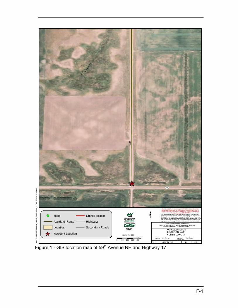
1.2 Accident Site Description The site of the accident was 59 th Avenue NE and ND Highway 17, 8 miles west of Cando, ND. 59 th Avenue is a gravel road. Highway 17 is a paved, twolane highway between Cando and Wolford, ND. The highway and gravel roads at the location of the accident are flat and straight without visible obstructions.
The organizations involved with this accident were Western, North Dakota Highway Patrol (NDHP), Towner County Sheriff Office, Cando Ambulance Service, Cando Fire Department, Towner County Memorial Hospital, Towner County Coroner Office and Life Source St. Paul, MN.
1.3 Scope, Purpose, Conduct and Methodology of the Investigation On July 15, 2008, the Board met for the first time via conference call. The Board planned and scheduled the accident investigation. The Board was told initially that the NDHP was creating an accident reconstruction report that would have all of the necessary facts.
2
1.3.1 Scope The scope of the Board’s investigation was to review and analyze the circumstances to determine the accident’s causes. The Board planned to visit the accident site and interview all Western employees involved with the accident.
1.3.2 Purpose The purpose of this investigation was to determine the cause of the vehicle accident, report any deficiencies in procedures, training, employee performance, defective equipment or management systems that may have contributed to the accident. The conclusions and judgments of need from this investigation should be used for developing and implementing corrective actions that will reduce or eliminate a recurrence of the similar incidents.
1.3.3 Conduct The Board traveled to Bismarck, ND, July 20, 2008. On the morning of July 21, 2008, the Board arrived at the North Dakota Maintenance Office in Bismarck where the Board setup for the week and began conducting interviews. The Board contacted Western personnel and the following emergency services: Towner County Sheriff, NDHP and Towner County Coroner to arrange for information and interviews.
The Board visited the accident site on July 22, 2008, conducted interviews and gathered information from the NDHP, Towner County Sheriff Office, Cando Ambulance Service, Cando Fire Department, Towner County Memorial Hospital and Towner County Coroner Office.
The Board obtained copies of the NDHP Investigator’s Motor Vehicle Accident Report, Towner County Sheriff Office Motor Vehicle Accident Report, Towner County Memorial Hospital Medical Report, Towner County Coroner Office Medical Certification of Death Worksheet, Life Source St. Paul, MN, Organ and Tissue Donation Disclosure, accident photographs, Weather Source weather report for June 30 through July 2, 2008, and the Western employees training and safety records along with the accident vehicle’s maintenance records. (Refer to Appendix D: Reference List)
The Board interviewed all Western employees that were involved in the accident. The following statement was read to each at the start of the interview:
“We are talking to you as part of the DOE Type A Accident Investigation. From DOE Order 225.1A, the purpose of this investigation is to prevent the recurrence of such accidents and contribute to improved safety of DOE, employees, contractors and the public without determining individual fault or punitive measures. Our investigation consists of three areas:
1. Verify and supplement, if needed, the North Dakota Department of Transportation Crash Report.
2. Determine if there are any ancillary issues pertaining to the accident. 3. Review the emergency response.”
3
1.3.4 Methodology The Board organized and validated information gathered during the site visit the following week. The facts were sorted and listed in a tabular format which included the sources for each of the facts. A time line was also developed for each of the significant events. This information was then analyzed using various techniques such as causal factor charting and barrier analysis to determine casual factors. The Board also incorporated the Safe Start principles to help identify casual factors. Each of these analysis processes involved the entire team. This process resulted in the conclusions and resulting judgments of need.

4
2.0 Accident Facts and Analysis
2.1 Accident Description A motor vehicle accident fatality occurred at approximately 1210 CDT July 1, 2008, at the twoway stop intersection of gravel road 59 th Avenue NE and paved Highway 17—8 miles west of Cando, Towner County, ND. A Western employee in a GSA Western vehicle (V1) was killed while a passenger in one of two Western vehicles that were traveling south on 59 th Avenue NE.
Both vehicles had been participating in various field site visits and were enroute to their next destination. The lead vehicle (V2) produced heavy dust due to dry road conditions. V2 stopped at the intersection, angled slightly to the west, waiting for cross traffic before making a right hand turn onto Highway 17. When V1 saw V2 through the dust cloud stopped at the intersection, V1 was too close to stop, swerved to the left to avoid V2 and collided with V2 from behind (rearended).
2.1.1 Accident Background The weather was clear, temperature was approximately 79 degrees Fahrenheit with dry conditions and high humidity (61 percent), wind was unusually light (slight northwest breeze). Maximum speed limit in ND is 55 miles per hour on gravel, dirt or loose surface roads unless otherwise posted. Both vehicles were traveling south on the gravel road, with V1 following V2 before the accident. The estimated speed of V1 was between 50 to 55 mph. All occupants were wearing seat/shoulder belts. The gravel road was dry and produced dusty conditions for the following vehicle.
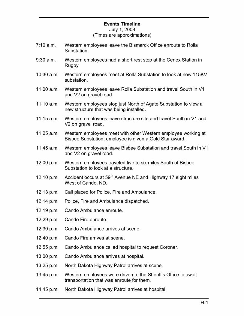
2.1.2 Chronology of Events A list of key events and their estimated time of occurrence is included in Appendix H: Events Timeline.
2.1.2.1 PreCrash Events Description: Two Western employees from the North Dakota Maintenance office in Bismarck, had planned June 30, 2008, to make various visits to field locations (Rolla, Agate, Bisbee, Leeds and Devils Lake), visiting with members of the Devils Lake line crew doing miscellaneous jobs and to view previous transmissionline work in the same area. The planned route was Interstate 94 to Steel, north on Highway 3, stop at Rugby, continue north on Highway 3 to Dunseith; east on Highway 281 to Rolla Substation; south on 59 th Avenue NE; east on Road 66 to Bisbee; south 59 th Avenue NE to Highway 17 (accident site) and then on to Leeds and Devils Lake, ND. Refer to Appendix F: Figure 2. The planned route and work for the day were attainable for a day’s travel and there was no sense of urgency. Return was estimated at 1730 CDT to the Bismarck office.
On July 1, 2008, at approximately 0710 CDT, two Western employees departed the Bismarck office (V1), stopping in the town of Rugby for a short rest break. Continuing on to Rolla Substation, the two Western employees met with another Western employee from a North Dakota field office (V2). Vehicle to vehicle

5
communications were available via cell phones and/or Western’s mobile radio system. The only use of communications between vehicles was a cell phone call from V1 passenger to alert the driver of V2 to meet at Rolla Substation. At the Bisbee Substation, the group decided to follow the transmission line and then go to lunch at the town of Leeds. At Bisbee Substation the two employees in V1 changed drivers; the new driver was familiar with the vehicle having operated it before. V1 followed V2 to the next destination.
While driving on 59 th Avenue NE, dust was created by V2 which was unusually thick and did not dissipate, hanging over the road. During some of the gravel road trip, the light breeze would push the dust away and the new driver of V1 made adjustments for visibility (speed and distance). Three miles south of Bisbee, V1 and V2 stopped to view tree removal along the transmission line that a farmer had done. During the remainder of travel on the road to the accident scene, the driver of V1 was pointing out to the passenger several transmission line items south of Bisbee. The last specific distraction noted by the driver of V1 was 2 miles before the accident site— pointing out the tie line to the Cando Tap.
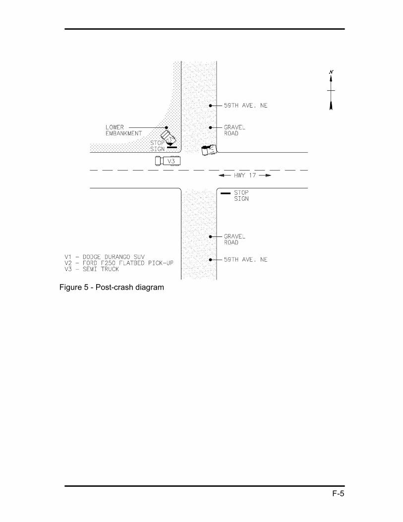
2.1.2.2 Crash Events Description: Driving on 59 th Avenue NE, before the accident, the driver of V1 assumed there was another 15 miles to Leeds as he was unfamiliar with the road, having driven on it only a couple of times in 26 years. Due to the visual obstruction caused by the dust of the lead vehicle (V2) not dissipating, the visibility for V1 was hindered. V2 stopped at the stop sign at the intersection of Highway 17 and 59 th Avenue NE, awaiting the passing of a semitractor trailer approaching on Highway 17 from the east. When V2 became visible to V1, V1 was too close to stop, and V1 swerved to the left trying to avoid V2. V1 hit V2, 2 to 3 seconds after V2 had stopped at the stop sign. The right front of V1 impacted the left rear of V2. The front and side air bags of V1 deployed. The force of the impact caused V1 to turn to a 90degree angle heading west at the intersection and V2 to veer to the northwest of the intersection corner down into an embankment. The crash energy from the impact was focused on the front passenger side of V1. As a result, the Western passenger of V1 suffered massive blunt trauma to the head, neck and chest causing death. The time of death listed on the Certification of Death was 1218 CDT, July 1, 2008. The driver of V1 had minor injuries and the driver of V2 had an injured shoulder.
2.1.2.3 PostCrash Events Description: At the time of the accident, the driver of the semitractor trailer approaching the intersection on Highway 17 from the east, stopped at the scene and called 911 for emergency services at approximately 1213 CDT. As a result of the emergency call, the Towner County emergency services in Cando (ambulance, fire and sheriff) were dispatched to the accident scene. The Cando Ambulance Service arrived at 1230 CDT and the Cando Fire EMTs arrived at 1240 CDT.
At the scene, V1 driver noticed the passenger was nonresponsive and both drivers of V1 and V2 provided first aid. Once the EMTs arrived on the scene, they took

6
charge of emergency actions to aid the passenger of V1. Due to the force of the collision, the passenger of V1 had to be extricated from the vehicle. At the site, the EMTs determined that the passenger of V1 did not have any vital signs. He was transported to the Towner County Medical Center at 1300 CDT.
The Cando Sheriff at the scene interviewed both survivors of the accident and reported in his final report that there was no evidence of drug or alcohol presence or any signs or form of impairment on those involved.
The NDHP arrived at the scene at 1345 CDT. The NDHP’s Motor Vehicle Crash Report noted a citation was issued to the driver of V1: “Care Required.” Per North Dakota Vehicle Law, Chapter 390901.1.; drivers will have “due regard to the traffic, surface, and width of the highway and other conditions then existing…” The NDHP later performed an accident reconstruction analysis of the incident.
The drivers of both V1 and V2 were transported by the Cando Sheriff to his office where they were picked up by supporting Western personnel to transport them to their duty stations (Bismarck for V1 and Devils Lake for V2 driver).
2.2 Accident Response As a result of the emergency call, the Towner County emergency services in Cando (ambulance, fire and sheriff) were dispatched to the accident scene. The Cando ambulance and fire are volunteer staffed organizations typical of similar rural areas.
2.3 Accident Notifications and Team Formation Soon after the accident, V1 driver called line management to notify him of the incident and to tell him that he did not think V1 passenger “had made it”. The supervisor, in turn, notified the UGP Regional Manager. After confirmation of V1 passenger’s death, the notification processes internally and externally were started. It was decided that notification of next of kin should be made by a Western employee and would be done in person. Notification of next of kin was made by a Western employee at 1400 CDT, July 1, 2008. There was some urgency for this notification because the V1 passenger was an organ donor. Notification to North Dakota Maintenance Office personnel was made by the acting manager. Western wide notification was made by the Administrator approximately three hours after the accident. Affected agencies (DOE and Department of Labor/Office of Workers Compensation) were notified on July 1, 2008.
Counseling arrangements were made for Bismarck and Devils Lake personnel for three separate sessions, with the first session July 3, 2008, by the Employee Assistance Program (EAP).
The decision to form a Type A Accident Investigation Board was not formalized until July 9, 2008. In consultation with DOE, Western management discussed the need to perform a Type A investigation because DOE Order 225.1A, Attachment 2 does not require investigation of offsite motor vehicle accidents.

7
Also, Western expected a detailed NDHP report to be issued based on information at the site that the NDHP was doing a “reconstruction” of the accident. However, the report was not forthcoming within a reasonable amount of time (DOT motor vehicle crash report was received July 16, 2008). In addition, once the report was received, the report was not extensive.
2.4 Ancillary Issues In reviewing training records for personnel involved in the accident, training was current. Involved personnel in the Bismarck and Devils Lake offices are current in attending a Defensive Driving training course provided by the North Dakota Safety Council in March 2007. Safe Start training, a behaviorbased safety training program was provided by Western in February and March 2008. Records for training were readily available and current. Safe Start principles have been incorporated into safety meetings, training sessions and other applications within the region.
CPR/First Aid training classes are provided to UGP regional personnel. At the incident scene, immediately following the accident, first aid was offered at the accident scene by both drivers of V1 and V2 to the passenger of V1. A first aid kit and supplies were available in both vehicles and both drivers were willing and trained to offer assistance.
Through interviews, the board noted that local management routinely participated in and openly supported the safety program. Participation in job site visits, safety meetings and work activities is a regular activity for local management. Administrative and safety personnel completed all necessary incident reporting forms and records and routed them to the proper agency.
Vehicle records for maintenance and history of both vehicles involved in the incident were current and readily available. Both vehicles had the required periodic service maintenance performed and there was no record of problems or equipment failure noted.

8
3.0 Analysis
The Board uses several analysis techniques to determine the casual factors.
3.1 Event and Causal Factors The analysis of the accident includes an Event and Causal Factors chart (Appendix C) to graphically depict the information gathered. This chart helped the Board to determine the causal factors and reach conclusions regarding the causes and to form judgments of needs.
3.2 Barrier Analysis In addition, the Board performed a Barrier Analysis for the hazard of a vehicle colliding with objects while driving. This analysis is shown in Appendix B: Barrier Analysis Summary. The Board identified four barriers applicable to this accident. Three of these failed to prevent the accident: 1) maintain visibility; 2) maintain adequate following distance to avoid collision; and 3) maneuvering ability.
3.3 Safe Start Program Analysis The Board included analysis of this accident applying Safe Start program principles:
• “Eyes not on task:” V1 driver did not have “Eyes on task” as driver of V1 could not see ahead of the vehicle because of the dust generated by V2.
• “Line of fire:” V1 driver being conscious of the proximity of V2 in relation to the V1 in terms of the direction and distance between the hazardous energy (collision). Entering the line of fire was that the driver of V1 drove into the dust cloud generated by V2.
• “Complacency:” V1 driver was making adjustments (speed and distance) based on visibility of the dust cloud generated by V2 before the incident and may have become complacent about losing visibility of road ahead.
Taken together, these Safe Start critical errors can also be described as a loss of situational awareness.
3.4 Speed and Stopping Distance Analysis During the travel south on 59 th Avenue NE, V1’s speed (50 to 55 mph) and following distance (V1 driver stated speed and distance were adjusted depending on visibility) were proper. When V1 entered the dust cloud and lost the following distance visibility margin, his speed and following distance were not proper at that time. The Board’s analysis (Appendix D: Stopping Distance Charts) considering the estimated speed of V1, the time between V2 stopped at the intersection and the collision, and the typical stopping distance at 55 mph is that V1 would have had to perform an emergency stop upon entering the dust cloud to have any chance to avoid colliding with V2.

9
3.5 Causal Factors: 1. V1 driver unfamiliar with area, road and route (contributing cause).
V1 driver stated he had been on road a couple of times in past 26 years.
2. Road type and weather conditions (contributing cause). Gravel road. Dry, with light to calm breeze. Heavy dust from V2 hanging over road.
3. V1 driver not expecting stop sign before lunch at Leeds (contributing cause). V1 driver assumed 15 miles to Leeds.
4. After entering the dust cloud, V1 speed and following distance were not proper for the conditions (contributing cause).
5. V1 driver did not maintain adequate visibility of objects in path of vehicle (root cause).
V1 entered area of inadequate visibility. When V1 driver saw V2 stopped, there was no time to avoid the collision.

10
4.0 Conclusion and Judgments of Need
From the information the Board gathered and as a result of the analysis described in Section 3.0, the team has the following conclusions and judgments of need:
Conclusions 1. V1 driver was unfamiliar with area, road and route.
2. Road type and weather conditions contributed to difficult driving conditions.
3. V1 driver not expecting stop sign on the way to lunch at Leeds.
4. After entering the dust cloud, V1 speed and following distance were not proper for the conditions.
5. V1 driver did not maintain adequate visibility of objects in path of vehicle.
6. The response by the emergency services agencies was good. This conclusion considers the volunteer nature of some of the services and rural location.
7. The activities for July 1, 2008, were well planned and there was adequate time to accomplish them. No sense of urgency or rushing was found.
8. The numerous notifications required by this accident were proper and timely.
9. EAP counseling services were timely and helpful.
10.Formation of DOE Type A accident investigation team and the start of the team’s activities was not timely.
11.The safety program, management support, and culture in the ND Maintenance Office are sound, and are meeting the needs of the organization.
Judgments of Need 1. Western should use the lessons from this tragic accident to enhance current
driver training programs to include, for example, adjusting to varying road conditions (heavy dust, fog, snow, and rain), requirement to maintain visibility, situational awareness, and proper following distance.
2. Western should research means to reduce driving hazards such as additional warning devices, convoying techniques, pretrip briefings, intervehicle communications, and industry/government best practices. Adopt those which will effectively improve driving safety.

11
5.0 Board Signatures
12
6.0 Board Members, Advisors and Staff
Board Members Charles W. Cooper, Maintenance Manager, SN Lewis C. Trujillo, Communications & Instrumentation Foreman III, DSW Victoria L. Anderson, Safety Specialist, SN
Advisors Gary Hoffman, Attorney, CSO Kathy Patchell, Safety Specialist, CSO
Support Josh Katzman, GIS Support, SN Tiffani Chopko, Technical Writing, CSO Joel Klassen, Graphics Support, CSO Dean Steel, CAD Support, SN Tuan Hoang, SCEP Electrical Engineer Student, SN

Appendix A
Appointment of Type A Accident Investigation Board

A1

Appendix B
Barriers Analysis Summary

B1
Barriers Analysis Summary
Hazard: Collision with objects while driving
Target: Vehicle Occupants
“What are the Barriers?”
“How did the barrier
perform?”
“Why did the barrier fail?”
“How did the barrier affect the accident?”
Maintain visibility of objects in path of vehicle with enough distance to avoid collision.
Failed V1 driver drove into dust cloud created by V2
Presence of dust obscured vision of driver of V1
Maintain adequate following distance to avoid collision.
Failed. Following distance would require 346’ for stopping while traveling at 55mph
Driver of V1 not adhering to enough stopping distance between vehicles
Braking of vehicle
Not applicable (brakes not used)
No time to apply brakes
Not applicable (brakes not used)
Maneuvering ability
Failed. V1 attempted to swerve to left – not enough time/distance to complete maneuver
Driver of V1 was unable to maneuver V1 around V2 to stop in time

Appendix C
Events and Causal Factors Chart

C1

C2

Appendix D
Stopping Distance Charts

D1
Stopping Distance
Estimated vehicle speed – 50 to 55 mph
Time between V2 stopped at intersection and collision with V1 was 2 to 3 seconds
Distance Traveled in Feet
Typical stopping distance at 55 mph is 346 feet (dry pavement). (Source: National Safety Council Defensive Driving Course 4, dated 2007, page 14)
Each of the distances traveled are much less then the typical stopping distance required at 55 mph.
Several physical factors such as the dynamics of V2 slowing to a stop at the intersection and the unknown length of the dust cloud behind V2 prevent calculation of available stopping distance.
Time (seconds) (Speed mph) 2 3
50 147 220 55 161 242

D2

Appendix E
Reference List

E1
Reference list
DOE Order 225.1A Accident Investigation
North Dakota Highway Patrol Investigator’s Motor Vehicle Accident Report
North Dakota Vehicle Law, Chapter 3909 “Speed Restrictions,” 39.09.01.1 Care Required in Operating Vehicle. “Care Required in operating a vehicle. Any person driving a vehicle upon a highway shall drive the vehicle in a careful and prudent manner, having due regard to the traffic, surface, and width of the highway and other conditions then existing, and shall give such warnings as are reasonably necessary for safe operation under the circumstances. No person may drive any vehicle upon a highway in a manner to endanger the life, limb, or property of any person.”
Towner County Sheriff Office Motor Vehicle Accident Report
Towner County Memorial Hospital Medical Report
Towner County Coroner Office Medical Certification of Death Worksheet
Life Source Organ & Tissue Donation Disclosure
Accident photographs
Weather Source weather reports for June 30 th , July 1 st and July 2 nd
Western employees training and safety records
Accident vehicle’s maintenance records
National Safety Council, Defensive Driving Course 4, pg. 14 and 15
North Dakota Safety Council – Chapter of National Safety Council

Appendix F
Figures
F1
Figure 1 GIS location map of 59 th Avenue NE and Highway 17

F2
Figure 2 GIS area map of North Dakota – route of workday

F3
Figure 3 Precrash diagram

F4
Figure 4 Actual crash diagram
F5
Figure 5 Postcrash diagram

Appendix G
Photographs

G1
Photographs 1 and 2
South on 59 th Avenue, heading south simulating road conditions.
Simulated road conditions heading south on 59 th Avenue approaching the intersection at Highway 17.

G2
Photograph 3
Normal road condition at Intersection 59 th Avenue and Highway 17.

G3
Photograph 4
Photo diagrams where V2 started and both vehicles’ final resting spots.

G4
Photographs 5 and 6
Dotted lines indicate where V2 final resting spot in embankment on northwest corner of intersection.
Dotted lines indicate where V2 entered embankment and the arrows show the approximate depth of the embankment.

G5
Photographs 7 and 8
Driver side front view of V1.
Photo shows the crash energy impact location.

G6
Photographs 9 and 10
Photo shows that all airbags deployed on impact.
Front view of V2.

G7
Photographs 11 and 12
Photos show damage from crash to V2.

Appendix H
Events Timeline
H1
Events Timeline July 1, 2008
(Times are approximations)
7:10 a.m. Western employees leave the Bismarck Office enroute to Rolla Substation
9:30 a.m. Western employees had a short rest stop at the Cenex Station in Rugby
10:30 a.m. Western employees meet at Rolla Substation to look at new 115KV substation.
11:00 a.m. Western employees leave Rolla Substation and travel South in V1 and V2 on gravel road.
11:10 a.m. Western employees stop just North of Agate Substation to view a new structure that was being installed.
11:15 a.m. Western employees leave structure site and travel South in V1 and V2 on gravel road.
11:25 a.m. Western employees meet with other Western employee working at Bisbee Substation; employee is given a Gold Star award.
11:45 a.m. Western employees leave Bisbee Substation and travel South in V1 and V2 on gravel road.
12:00 p.m. Western employees traveled five to six miles South of Bisbee Substation to look at a structure.
12:10 p.m. Accident occurs at 59 th Avenue NE and Highway 17 eight miles West of Cando, ND.
12:13 p.m. Call placed for Police, Fire and Ambulance.
12:14 p.m. Police, Fire and Ambulance dispatched.
12:19 p.m. Cando Ambulance enroute.
12:29 p.m. Cando Fire enroute.
12:30 p.m. Cando Ambulance arrives at scene.
12:40 p.m. Cando Fire arrives at scene.
12:55 p.m. Cando Ambulance called hospital to request Coroner.
13:00 p.m. Cando Ambulance arrives at hospital.
13:25 p.m. North Dakota Highway Patrol arrives at scene.
13:45 p.m. Western employees were driven to the Sheriff’s Office to await transportation that was enroute for them.
14:45 p.m. North Dakota Highway Patrol arrives at hospital.


