WFP Southern Africa Seasonal Update Regional Bureau for Southern Africa (RBJ) As early as July, the CPC/IRI* issued a La Niña Watch and in early October, it was reported that La Niña conditions have re-emerged for the 2021/22 season. The CPC/IRI’s latest official forecast indicates 87% chance of La Niña conditions persisting in December 2021 - February 2022, and at its peak could reach a moderate strength La Niña (Box 1). This year’s La Niña conditions come on the back of a moderate La Niña in the 2020/21 season, which was characterized by 12 named tropical storms in the South- West Indian Ocean, of which 7 were tropical cyclones. 5 tropical systems made landfall, primarily affecting countries such as Mozambique, Madagascar, Zimbabwe and Malawi. As a result, parts of the region experienced severe weather and flooding last year, calling for close monitoring and preparedness this year. On a positive note, above average rainfall likely implies another year of good cereal production for the region. As seen in the previous season, above average rainfall across much of the region led to favourable end of maize harvest conditions (exceptional in South Africa, Zimbabwe and Malawi, and favourable in Zambia, Tanzania, Mozambique, Eswatini and Lesotho, Figure 1). Favourable livestock conditions were also reported across most of the region. Although there is reason to be cautiously optimistic that a similar scenario could unfold again this season, potential issues such as possible outbreaks of African Migratory Locust (AML) as the weather gets warmer and outbreaks of Avian influenza require continued monitoring. Key La Niña Outlook October 2021 Page 1 Highlights • Latest El Niño Southern Oscillation (ENSO) updates indicate that La Niña conditions have re-emerged for the second consecutive year. As of October, ENSO forecasts expect these conditions to continue with 87% chance of La Niña in December 2021- February 2022. • Taking into account oceanic and atmospheric factors and the La Niña occurrence, the bulk of the Southern Africa region is expected to experience above-average rainfall in the 2021/22 season. While this may portend well for overall regional crop production, close monitoring and preparedness is needed as some areas may experience high cyclonic activities, severe weather events and flooding similar to last year. Measures also need to be put in place to ensure the positive outlook can be maximized. • Key areas of concern for normal to below normal rainfall throughout the October-November-December (OND) and January-February-March (JFM) periods are parts of western Angola and potentially western Namibia according to the regional SARCOF Seasonal Forecast. • WFP VAM activities to prepare for the season include: 1) data preparedness (e.g. spatial data infrastructure for the 72 hour assessment approach), 2) high frequency monitoring of rainfall, tropical systems, seasonal progress and 3) partnerships for enhanced monitoring and disaster risk intelligence . Box 1 La Nina Southern Oscillation (ENSO) • One of the main climate phenomenona that affects weather patterns in the southern Africa region. La Niña is typically associated with bringing a cool and wet season to the bulk of the Southern Africa region. • The latest IRI/CPC official probabilistic ENSO forecasts indicate approximately 87% chance of a La Niña conditions persisiting into December 2021 - February 2022. Source: IRI/CPC Figure 1 Final Maize End of Season Map (May 2021) *U.S. National Oceanic and Atmospheric Administration (NOAA) Climate Prediction Center and Columbia University’s Earth Institute, International Research Institute Early-October 2021 CPC/IRI Official Probabilistic ENSO Forecasts ENSO state based on NINO 3.4 SST Anomaly Neutral ENSO: -0.5°C to 0.5°C
Transcript
WFP Southern Africa Seasonal Update
Regional Bureau for Southern Africa (RBJ)
As early as July, the CPC/IRI* issued a La Niña Watch and
in early October, it was reported that La Niña conditions
have re-emerged for the 2021/22 season. The CPC/IRI’s
latest official forecast indicates 87% chance of La Niña
conditions persisting in December 2021 - February 2022,
and at its peak could reach a moderate strength La Niña
(Box 1).
This year’s La Niña conditions come on the back of a
moderate La Niña in the 2020/21 season, which was
characterized by 12 named tropical storms in the South-
West Indian Ocean, of which 7 were tropical cyclones. 5
tropical systems made landfall, primarily affecting
countries such as Mozambique, Madagascar, Zimbabwe
and Malawi. As a result, parts of the region experienced
severe weather and flooding last year, calling for close
monitoring and preparedness this year.
On a positive note, above average rainfall likely implies
another year of good cereal production for the region. As
seen in the previous season, above average rainfall across
much of the region led to favourable end of maize harvest
conditions (exceptional in South Africa, Zimbabwe and
Malawi, and favourable in Zambia, Tanzania, Mozambique,
Eswatini and Lesotho, Figure 1). Favourable livestock
conditions were also reported across most of the region.
Although there is reason to be cautiously optimistic that a
similar scenario could unfold again this season, potential
issues such as possible outbreaks of African Migratory
Locust (AML) as the weather gets warmer and outbreaks
of Avian influenza require continued monitoring. Key
La Niña Outlook
October 2021 Page 1
Highlights
• Latest El Niño Southern Oscillation (ENSO) updates indicate that La Niña conditions have re-emerged for the
second consecutive year. As of October, ENSO forecasts expect these conditions to continue with 87% chance
of La Niña in December 2021- February 2022.
• Taking into account oceanic and atmospheric factors and the La Niña occurrence, the bulk of the Southern
Africa region is expected to experience above-average rainfall in the 2021/22 season. While this may portend
well for overall regional crop production, close monitoring and preparedness is needed as some areas may
experience high cyclonic activities, severe weather events and flooding similar to last year. Measures also
need to be put in place to ensure the positive outlook can be maximized.
• Key areas of concern for normal to below normal rainfall throughout the October-November-December
(OND) and January-February-March (JFM) periods are parts of western Angola and potentially western
Namibia according to the regional SARCOF Seasonal Forecast.
• WFP VAM activities to prepare for the season include: 1) data preparedness (e.g. spatial data infrastructure
for the 72 hour assessment approach), 2) high frequency monitoring of rainfall, tropical systems, seasonal
progress and 3) partnerships for enhanced monitoring and disaster risk intelligence .
Box 1 La Nina Southern Oscillation (ENSO)
• One of the main climate phenomenona that affects weather patterns in the southern Africa region. La Niña is typically associated with bringing a cool and wet season to the bulk of the Southern Africa region.
• The latest IRI/CPC official probabilistic ENSO forecasts indicate approximately 87% chance of a La Niña conditions persisiting into December 2021 - February 2022.
Source: IRI/CPC
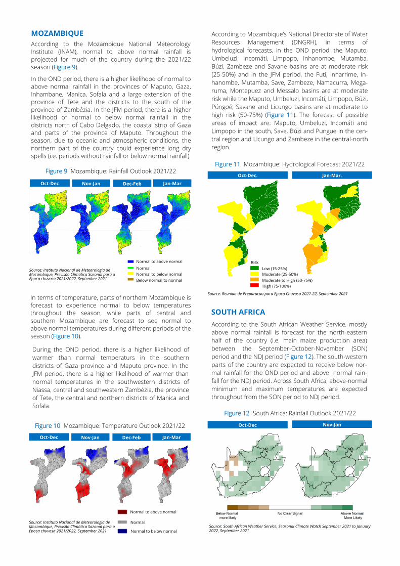
Figure 1 Final Maize End of Season Map (May 2021)
*U.S. National Oceanic and Atmospheric Administration (NOAA) Climate Prediction Center and
Columbia University’s Earth Institute, International Research Institute
Early-October 2021 CPC/IRI Official Probabilistic ENSO Forecasts ENSO state based on NINO 3.4 SST Anomaly