19
ENG Form 4345 Continuation West False River Salinity Barrier Project Prepared for: California Department of Water Resources October 2015
ENGForm4345Continuation
WestFalseRiverSalinityBarrierProject
Prepared for:
California Department of Water Resources
October 2015
ENGForm4345Continuation
WestFalseRiverSalinityBarrierProject
Prepared for:
California Department of Water Resources
1416 9th Street, Room 215‐37 Sacramento, CA 95814
Contact:
Jacob McQuirk 916/653‐9883
Prepared by:
AECOM 2020 L Street, Suite 400 Sacramento, CA 95811
Contact:
Cindy Davis Associate Principal
916/414‐5800
October 2015
AECOM West False River Salinity Barrier Project ENG Form 4345 Continuation i California Department of Water Resources
TABLE OF CONTENTS
Section Page
BOX 18: NATURE OF ACTIVITY ................................................................................................................................ 1
BOX 23: AVOIDANCE AND MINIMIZATION MEASURES ......................................................................................... 10
Figures
Figure 1 Regional Location of West False River Salinity Barrier Geologic Exploration ........................... 2 Figure 2 Aerial View of West False River Salinity Barrier Geologic Exploration Location ...................... 3 Figure 3. Photographs of the Project Site ..................................................................................................... 4 Figure 4 Stockpile Location ........................................................................................................................ 9

AECOM West False River Salinity Barrier Project ENG Form 4345 Continuation ii California Department of Water Resources
This page intentionally left blank.
AECOM West False River Salinity Barrier Project ENG Form 4345 Continuation 1 California Department of Water Resources
BOX 18: NATURE OF ACTIVITY
INTRODUCTION
Delta), the California Department of Water Resources (DWR) installed a project similar to the currently proposed project, the Emergency Drought Barrier (EDB) across West False River, in May-July 2015. Installation of the EDB was authorized under Executive Order B-29-15 (April 1, 2015 Directive to Streamline Government Response) and environmental authorizations from the U.S. Army Corps of Engineers (USACE) (SPK-2014-00187), State Water Resources Control Board (SWRCB) (Clean Water Act Section 401 Water Quality Certification), and California Department of Fish and Wildlife (CDFW) (2081-2014-026-03 and 1600-2014-0111-R3). Per the USACE Clean Water Act 404 emergency authorization, the EDB will be removed entirely in fall 2015.
The proposed West False River Salinity Barrier Project (WFRSB or Project) seeks to protect the quality of water for users that rely on Delta water. Keeping saltwater out of the central Delta is a priority, as a large portion of the state’s freshwater supplies travels through this part of the Delta. As shown with the EDB, a salinity barrier helps prevent saltwater contamination of water supplies used by people who live in the Delta and in Contra Costa, Alameda, and Santa Clara counties, as well as the 25 million people who rely on the Delta-based federal and state water projects for at least some of their supplies.
The WFRSB consists of the following items:
► installing embankment rock (i.e., temporary salinity barrier) and abutments (king piles, sheet piles, and whalers) as early as April 1, 2016; and
► removing the embankment rock and abutments by November 30, 2016.
The WFRSB would only be constructed if DWR, in co-operation with other State and federal agencies, determines that a drought has reduced water storage in the State Water Project (SWP) to critical levels, such that projected Delta outflow could not control increased salinity in the Delta, thereby worsening water quality and threatening the drinking and irrigation water supply. Operation of the salinity barrier as part of overall Central Valley Project (CVP) and SWP operations would occur through existing rules and regulations under relevant federal and state regulatory agencies.
PROJECT DESCRIPTION
PROJECT LOCATION
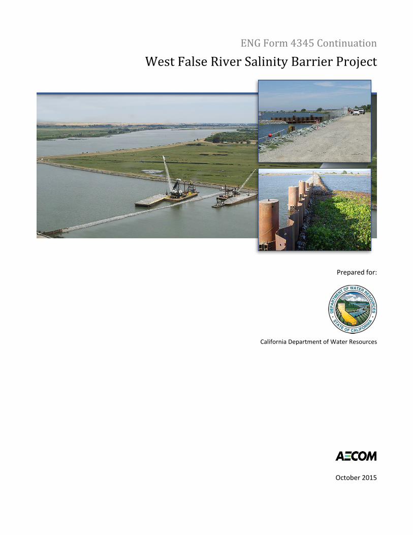
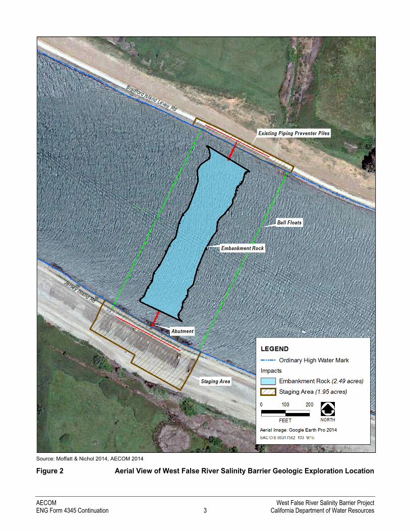
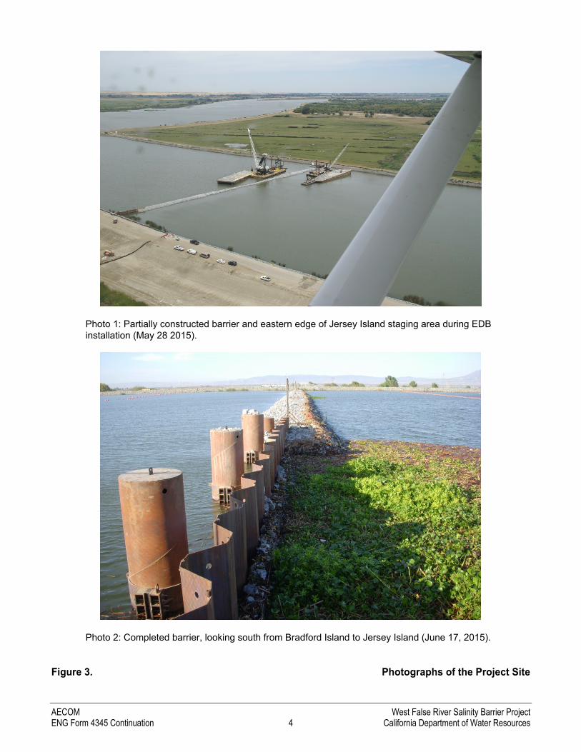
DWR would install the WFRSB on almost the identical EDB footprint (Figure 1 and Figure 2). The project site is located on West False River approximately 0.4 mile east of its confluence with the San Joaquin River, between Jersey and Bradford islands in Contra Costa County, and is approximately 4.8 miles northeast of Oakley. The banks of the project site are existing rock-lined levees. The project site would be approximately 4.44 acres, including 2.49 acres of aquatic fill and 1.95 acres on the levee and levee setback for staging. Photographs of the project site during and after installation of the EDB are provided in Figure 3.

AECOM West False River Salinity Barrier Project ENG Form 4345 Continuation 2 California Department of Water Resources
Source: Moffatt & Nichol 2014, AECOM 2014
Figure 1 Regional Location of West False River Salinity Barrier Geologic Exploration
AECOM West False River Salinity Barrier Project ENG Form 4345 Continuation 3 California Department of Water Resources
Source: Moffatt & Nichol 2014, AECOM 2014
Figure 2 Aerial View of West False River Salinity Barrier Geologic Exploration Location
AECOM West False River Salinity Barrier Project ENG Form 4345 Continuation 4 California Department of Water Resources
Photo 1: Partially constructed barrier and eastern edge of Jersey Island staging area during EDB installation (May 28 2015).
Photo 2: Completed barrier, looking south from Bradford Island to Jersey Island (June 17, 2015).
Figure 3. Photographs of the Project Site
AECOM West False River Salinity Barrier Project ENG Form 4345 Continuation 5 California Department of Water Resources
BARRIER INSTALLATION AND OPERATION
DESIGN
The WFRSB would consist of the following structures:
► Barrier Abutments: Eight (or four pairs) 36-inch-diameter king piles extending out from each levee into the West False River channel for a total length of approximately 75 feet.
► Seventy (or 35 pairs) sheet piles totaling approximately 160 wall feet (including approximately 5 feet on either side that would be in the levee). DWR would attach horizontal whalers to the piles for strength and stability.
► Buoy Line Anchors: Four 12-inch steel pipe piles.
The barrier would be approximately 800 feet long and up to 200 feet wide at the base (in water) and 12 feet wide at the top (above water). The WFRSB would be trapezoid-shaped with a wide base tapering up to a 12-foot-wide top width set perpendicular to the channel alignment. The top of the WFRSB would be at an elevation of 7 feet above sea level across the entire crest. As shown in Figure 2, the WFRSB would consist of approximately 74,000 cubic yards (2.49 acres) of crushed embankment rock (approximately 18 inches or smaller) connected to barrier abutments to be installed on Bradford and Jersey islands. The barrier abutments provide levee stability by reducing barrier loading (weight) on the levees which sit atop peat soils.
SCHEDULE
Construction activities, including mobilization, would begin no sooner than April 1, 2016. Similar to the installation of the EDB in 2015, placement of embankment rock would occur on a 24-hour basis for approximately 45 working days. Most likely, however, placement of embankment rock will not be entirely continuous in a 24-hour period due to the effect the tides have on barge navigation. The construction crew size for installation is assumed to be a maximum of 21 people.
CONSTRUCTION METHODOLOGY
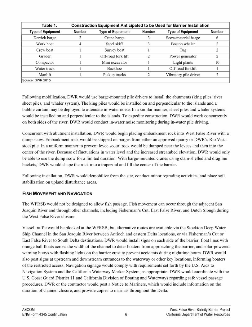
The construction methodology will be similar to that used on the EDB. First, DWR would mobilize equipment, establish a staging area adjacent to Jersey Island Road (i.e., left bank), and install silt and exclusion fencing on land along the construction boundaries. Next, material would be transported to the site on barges and trucks. A list of construction equipment anticipated to be used for installation of the abutments and rock barrier is provided in Table 1.
AECOM West False River Salinity Barrier Project ENG Form 4345 Continuation 6 California Department of Water Resources
Table 1. Construction Equipment Anticipated to be Used for Barrier Installation
Type of Equipment Number Type of Equipment Number Type of Equipment Number
Derrick barge 2 Crane barge 3 Scow/material barge 6
Work boat 4 Steel skiff 3 Boston whaler 2
Crew boat 1 Survey boat 1 Tug 2
Grader 1 Off-road fork lift 2 Power generator 2
Compactor 1 Mini excavator 1 Light plants 10
Water truck 1 Backhoe 1 Off-road forklift 1
Manlift 1 Pickup trucks 2 Vibratory pile driver 2 Source: DWR 2015
Following mobilization, DWR would use barge-mounted pile drivers to install the abutments (king piles, river sheet piles, and whaler system). The king piles would be installed on and perpendicular to the islands and a bubble curtain may be deployed to attenuate in-water noise. In a similar manner, sheet piles and whaler systems would be installed on and perpendicular to the islands. To expedite construction, DWR would work concurrently on both sides of the river. DWR would conduct in-water noise monitoring during in-water pile driving.
Concurrent with abutment installation, DWR would begin placing embankment rock into West False River with a dump scow. Embankment rock would be shipped on barges from either an approved quarry or DWR’s Rio Vista stockpile. In a uniform manner to prevent levee scour, rock would be dumped near the levees and then into the center of the river. Because of fluctuations in water level and the increased streambed elevation, DWR would only be able to use the dump scow for a limited duration. With barge-mounted cranes using clam-shelled and dragline buckets, DWR would shape the rock into a trapezoid and fill the center of the barrier.
Following installation, DWR would demobilize from the site, conduct minor regrading activities, and place soil stabilization on upland disturbance areas.
FISH MOVEMENT AND NAVIGATION
The WFRSB would not be designed to allow fish passage. Fish movement can occur through the adjacent San Joaquin River and through other channels, including Fisherman’s Cut, East False River, and Dutch Slough during the West False River closure.
Vessel traffic would be blocked at the WFRSB, but alternative routes are available via the Stockton Deep Water Ship Channel in the San Joaquin River between Antioch and eastern Delta locations, or via Fisherman’s Cut or East False River to South Delta destinations. DWR would install signs on each side of the barrier, float lines with orange ball floats across the width of the channel to deter boaters from approaching the barrier, and solar-powered warning buoys with flashing lights on the barrier crest to prevent accidents during nighttime hours. DWR would also post signs at upstream and downstream entrances to the waterway or other key locations, informing boaters of the restricted access. Navigation signage would comply with requirements set forth by the U.S. Aids to Navigation System and the California Waterway Marker System, as appropriate. DWR would coordinate with the U.S. Coast Guard District 11 and California Division of Boating and Waterways regarding safe vessel passage procedures. DWR or the contractor would post a Notice to Mariners, which would include information on the duration of channel closure, and provide copies to marinas throughout the Delta.
AECOM West False River Salinity Barrier Project ENG Form 4345 Continuation 7 California Department of Water Resources
OPERATIONS AND MAINTENANCE
There are no operational features associated with either the WFRSB or abutments. Given the temporary nature of the WFRSB, maintenance would be minimal apart from maintenance of navigational aids (e.g., signage, float lines, lights, warning buoys); however, DWR would regularly inspect the WFRSB during operation and inform the permitting agencies (CDFW, USFWS, and NMFS) if any major maintenance activities are required.
BARRIER REMOVAL
SCHEDULE
The embankment rock would be removed no later than November 30, 2016. Late November coincides with the start of the rainy season when freshwater runoff typically occurs and flood risk increases. Initial ground disturbance activities, such as mobilization and installation of silt and exclusion fencing, would occur in September to inhibit giant garter snake from entering the construction work area. Given the volume of embankment rock, DWR anticipates excavation would occur continuously (i.e., 24 hours per day, 7 days per week) for up to 90 days. The construction crew size for removal is assumed to be a maximum of 21 people.
GENERAL CONSTRUCTION METHODOLOGY
The methodology described herein is general. Although removal activities would primarily be situated in-water, work would also occur from the levee embankments.
First, DWR would mobilize construction equipment and crew. A list of construction equipment anticipated to be used for removal of the abutments and rock barrier is provided in Table 2. DWR would utilize multiple barges with excavators, cranes, and work boats that would be transported on water to the barrier site. In-water work would occur on both sides of the barrier (e.g., barge-mounted cranes operating upstream and downstream).
Table 2. Construction Equipment Anticipated to be Used for Barrier Removal
Type of Equipment Maximum Number
Type of Equipment Maximum Number
Type of Equipment Maximum Number
Tug/barge 8 Excavator 3 Front-end loader 2
Long-reach excavator 3 Dump truck 4 Grader 1
Work boat 2 Dozer 1 Source: DWR 2015
Next, DWR would strategically place the barges adjacent to the barrier in order to excavate the rock. Barge-mounted cranes with clam-shell or dragline buckets and/or excavators would excavate the rock and place it on another barge. To prevent levee scour, rock removal would begin at the center of the channel and work toward the levees. Excavation would occur from the top of the barrier down to approximate pre-project streambed contours. DWR would restore the levee geometry to ensure compliance with any local maintaining agency or USACE requirements. DWR would conduct bathymetric surveys during, and immediately after barrier removal to confirm reestablishment of pre-project streambed contours.
DWR would transport the rock on a barge from the project site to the off-loading site, where it would be transferred onto dump trucks using conveyors, excavators, and loaders and then hauled to DWR’s Rio Vista

AECOM West False River Salinity Barrier Project ENG Form 4345 Continuation 8 California Department of Water Resources
stockpile location (outside of waters of the United States), which is depicted in Figure 4. DWR upgraded the stockpile site in summer 2015 as part of the DWR Delta Flood Emergency Facilities Improvement Project. Alternatively, the rock may be retained by the contractor and stored/used in accordance with their own separate permits and approvals.
Upon removal of the rock barrier, DWR would then remove the abutments, buoy piles, buoys, and signs. Divers would remove the abutments and buoy piles by cutting the structures below the original riverbed grade. Because the buoys and signs are anchored by concrete blocks, DWR would completely remove these structures by barge-mounted cranes. The contractor would be required to retain or properly dispose of these materials.
After the barrier is completely removed, the staging areas would be restored to approximate pre-project conditions and hydroseeded as appropriate. Any levee access roads that are damaged as a result of construction equipment or truck use would be restored to pre-construction conditions or better after construction is completed.

AECOM West False River Salinity Barrier Project ENG Form 4345 Continuation 9 California Department of Water Resources
Source: DWR, adapted by AECOM 2015
Figure 4 Stockpile Location
AECOM West False River Salinity Barrier Project ENG Form 4345 Continuation 10 California Department of Water Resources
BOX 23: AVOIDANCE AND MINIMIZATION MEASURES
DWR would implement a number of conservation measures as part of the proposed action to avoid and minimize potential effects on giant garter snake and federally listed fish species.
1. PREPARE AND IMPLEMENT AN EROSION CONTROL PLAN
An Erosion Control Plan will be prepared before beginning construction activities that will cause ground disturbance. Site-specific erosion-control, spill-prevention, sedimentation control, and runoff measures will be developed and implemented during construction activities as part of the plan to minimize the potential for erosion and sedimentation during barrier construction and removal.
If applicable, tightly woven fiber netting (mesh size less than 0.25 inch) or similar material will be used for erosion control and other purposes at the project site to ensure wildlife does not become trapped or entangled in the erosion control material. Coconut coir matting is an acceptable erosion control material, but no plastic mono-filament matting will be used for erosion control. Where feasible, the edge of the material will be buried in the ground to prevent wildlife from crawling underneath the material.
2. PREPARE AND IMPLEMENT A SPILL PREVENTION AND CONTROL PROGRAM
A Spill Prevention and Control Program will be prepared before the start of construction to minimize the potential for hazardous, toxic, or petroleum substances to be released into the project area during construction and operation. The program will be implemented during construction. In addition, DWR will place sand bags, biologs, or other containment features around the areas used for fueling or other uses of hazardous materials to ensure that these materials do not accidentally leak into the river. DWR will adhere to the standard construction best management practices described in the current California Department of Transportation Construction Site Best Management Practices Manual (California Department of Transportation 2003).
The Spill Prevention and Control Program will include procedures for mitigating potential spills caused by collision/stranding of vessel traffic with the barrier during its operation. Spill control materials will be kept at the barrier site and at additional DWR-owned locations in the Delta. The barrier will have clear signage with telephone contact details for DWR personnel as well as the Governor’s Office of Emergency Services (CalOES) hazardous materials (HAZMAT) spill notifications contact number (1-800-852-7550).
3. PREPARE AND IMPLEMENT A HAZARDOUS MATERIALS MANAGEMENT PROGRAM
A Hazardous Materials Management Program (HMMP) will be prepared and implemented to identify the hazardous materials to be used during construction; describe measures to prevent, control, and minimize the spillage of hazardous substances; describe transport, storage, and disposal procedures for these substances; and outline procedures to be followed in case of a spill of a hazardous material. The HMMP will require that hazardous and potentially hazardous substances stored onsite be kept in securely closed containers located away from drainage courses, storm drains, and areas where stormwater is allowed to infiltrate. It will also stipulate procedures to minimize hazard during onsite fueling and servicing of construction equipment. Finally, the HMMP will require that adjacent land users be notified immediately of any substantial spill or release.
AECOM West False River Salinity Barrier Project ENG Form 4345 Continuation 11 California Department of Water Resources
4. CONDUCT A WORKER ENVIRONMENTAL AWARENESS PROGRAM
Construction workers will participate in a Worker Environmental Awareness Program that addresses species under jurisdiction of the permitting agencies (CDFW, USFWS, and NMFS). Workers will be informed about the potential presence of listed and other protected species, and habitats associated with such species, and that unlawful take of the species or destruction of their habitat is a violation of the federal ESA, California Endangered Species Act (CESA), and/or Migratory Bird Treaty Act. Before the start of construction activities, a qualified biologist approved by the permitting agencies will instruct all construction workers about the life histories of the protected species and the terms and conditions of the applicable Biological Opinions (BOs), CESA Incidental Take Permit (ITP), and other regulatory permits that include biological resource protection measures. Proof of this instruction will be submitted to the permitting agencies.
5. CONDUCT BIOLOGICAL MONITORING
A qualified biologist approved by the permitting agencies will be onsite when daytime construction occurs to conduct compliance inspections and monitoring during barrier installation and removal. The qualifications of the biologist(s) will be presented to the permitting agencies for review and approval before beginning project activities at the project site. The complete set of permitting documents will be onsite during construction. The biologist(s) will be given the authority to stop work that may result in, or in the event that there is, take of listed species in excess of limits provided by the permitting agencies in any permitting document (BOs, CESA ITP). Should the biologist(s) exercise this authority, the permitting agencies will be notified by telephone and electronic mail within 1 working day.
A report of daily records from monitoring activities and observations will be prepared and provided to the permitting agencies upon completion of project activities.
6. CONDUCT REAL-TIME MONITORING AND ADJUST CONSTRUCTION ACTIVITIES ACCORDINGLY
DWR will monitor weather patterns and river forecasts for the period preceding the start of construction. If precipitation events or increases in river levels and flows are predicted to occur immediately before the start of construction, DWR will notify NMFS, USFWS, and CDFW before the start of construction and informally will confer with them to determine whether construction actions are still feasible as previously considered. Sudden increases in river flows, imminent precipitation events that create changes in river stage in the Sacramento and San Joaquin valleys, or observed sudden increases in turbidity in the Sacramento or San Joaquin rivers upstream of the Delta may initiate pulses of fish migration into the project channels (e.g., juvenile salmonids moving downstream, pre-spawning delta smelt moving upstream).
DWR also will monitor the capture of listed fishes in the fish monitoring programs currently being employed in and close to the barrier site, (i.e., at the nearest Interagency Ecological Program monitoring stations). If increasing presence of listed fishes (principally juvenile salmonids and smelts) is detected in these monitoring efforts during project implementation, DWR will immediately contact NMFS, USFWS, and CDFW to allow informal consultation to determine whether construction actions will place fish at substantial additional risk near the barrier site.

AECOM West False River Salinity Barrier Project ENG Form 4345 Continuation 12 California Department of Water Resources
7. CONDUCT PILE DRIVING WITH A VIBRATORY DRIVER TO THE EXTENT POSSIBLE; MINIMIZE
EFFECTS OF IMPACT DRIVING
DWR will conduct pile driving using a vibratory hammer to minimize to the extent possible the noise generated from pile-driving activities. NMFS (2015:50) noted in the Biological Opinion for the Woodward Island Bridge Project over Middle River that only the driving of piles with an impact hammer is expected to produce sound levels that could result in injury to fish, so the use of a vibratory hammer for the West False River salinity barrier abutments substantially reduces or avoids the potential to cause take of listed species. However, in certain circumstances (e.g., vibratory driving is not capable of reaching required embedment), impact pile driving may be necessary. If impact pile driving is necessary, bubble curtains will be employed to attenuate noise. Monitoring of underwater sound generated by the impact hammer during pile driving in the vicinity of the West False River barrier will be conducted to verify that sound level criteria are not being exceeded, i.e., 183-decibel sound exposure level (SEL) at 10 meters from pile driving. If levels are exceeded, the permitting fish agencies will be notified and work halted until corrective actions are instituted to achieve sound level criteria. Sound monitoring is not proposed for vibratory pile driving because there are no accepted threshold criteria for vibratory pile driving (Pearson-Meyer, pers. comm.).
8. INSTALL IN-WATER NAVIGATIONAL BUOYS, LIGHTS, AND SIGNAGE
Navigational buoys, lights, and signage will be installed in West False River upstream and downstream from the West False River salinity barrier, and proximate to Fisherman’s Cut, to advise boaters about the presence of the emergency salinity barrier and maintain navigation along both waterways. Temporary floating signs and buoys will be anchored to the bottom with cables and concrete anchor blocks. DWR will coordinate with the U.S. Coast Guard on signage and buoys.
9. IMPLEMENT TURBIDITY MONITORING DURING CONSTRUCTION
DWR will monitor turbidity levels in West False River during ground-disturbing activities, including placement of rock fill material and any major maintenance. Monitoring will be conducted by measuring upstream and downstream of the disturbance area to ensure compliance with the Water Quality Control Plan (Basin Plan) for the Sacramento River and San Joaquin River Basins (Central Valley Regional Water Quality Control Board 2011). For Delta waters, the general objectives for turbidity apply, except during periods of stormwater runoff; the turbidity of Delta waters shall not exceed 150 Nephelometric Turbidity Units (NTU). Exceptions to the Delta specific objectives are considered when a dredging operation can cause an increase in turbidity. In this case, an allowable zone of dilution within which turbidity in excess of limits can be tolerated will be defined for the operation and prescribed in a discharge permit.
DWR contractors will slow or adjust work to ensure that turbidity levels do not exceed those conditions described in the 401 certification issued by the SWRCB. If slowing or adjusting work to lower turbidity levels is not practical or if thresholds cannot be met, DWR will consult with the SWRCB and permitting agencies to determine the most appropriate measures to minimize turbidity impacts to the maximum extent feasible.
AECOM West False River Salinity Barrier Project ENG Form 4345 Continuation 13 California Department of Water Resources
10. DEVELOP AND IMPLEMENT A WATER QUALITY MONITORING PLAN
DWR will develop and implement a Water Quality Monitoring Plan to assess the effects of the proposed project on flow and water quality throughout the Delta. Monitoring data will be provided by strategically-placed stations installed as part of the EDB project. DWR also may use data from other existing and recently upgraded stations throughout the Delta.
DWR will monitor flow, stage, water velocity, water temperature, specific conductance, turbidity, chlorophyll, nutrients, bromide, and organic carbon, pH, and dissolved oxygen. DWR staff will post weekly water quality data summaries of the continuous data. Chlorophyll and nutrient data will be posted online as soon as the results are available.
The Water Quality Monitoring Plan will document the procedures for producing the following elements:
► Water quality data from monitoring sites; ► Weekly water quality summaries; ► Chlorophyll and nutrient data (discrete data) summaries as soon as the results are available; ► Final report on project effects on water quality.
11. LIMIT HABITAT DISTURBANCE, RETURN DISTURBED AREAS TO PRE-PROJECT CONDITIONS, AND PROVIDE MITIGATION HABITAT
DWR and its construction contractors will strive to limit habitat disturbance during project-related construction activities. Immediately following barrier removal, DWR will restore habitat to approximate pre-project conditions.
DWR will provide mitigation through a mitigation bank approved by USFWS and CDFW at a 1:1 ratio for temporary (less than 1 year) impacts on shallow water habitat associated with the barrier rock.
DWR will provide mitigation, as determined by USFWS and CDFW, for temporary impacts on giant garter snake habitat through purchase of credits at a USFWS- and CDFW-approved mitigation bank.
12. LIMIT LAND-BASED ACCESS ROUTES AND CONSTRUCTION AREA
The number of land-based access routes and size of the construction area will be limited to the minimum area necessary. Access routes will be restricted to established roadways. Construction area boundaries will be clearly demarcated.
13. IMPLEMENT PROTOCOLS FOR GIANT GARTER SNAKE
In addition to applicable measures described above, the following protocols will be implemented in order to avoid and minimize potential impacts to giant garter snakes that may be present on or adjacent to the project site.
► DWR will follow, as practicably as possible, the 1997 Programmatic Formal Consultation for U.S. Army Corps of Engineers 404 Permitted Projects with Relatively Small Effects on the Giant Garter Snake within Butte, Colusa, Glenn, Fresno, Merced, Sacramento, San Joaquin, Solano, Stanislaus, Sutter and Yolo Counties, California (Programmatic BO) (USFWS 1997).

AECOM West False River Salinity Barrier Project ENG Form 4345 Continuation 14 California Department of Water Resources
► DWR will coordinate with USFWS and CDFW regarding details and implementation of upland restoration activities and will refer to restoration guidelines provided in Appendix A of the Programmatic BO.
► Barrier removal activities will begin before October 1 to minimize potential for snakes to seek aestivation habitat within the project footprint (including on or near access roads) during barrier removal and upland restoration.
► Before barrier installation and removal activities begin, exclusion fencing, placed a minimum of 6-8 inches below ground, will be installed along the landside edge of the construction/staging areas. The appropriate location for the fencing will be determined by a qualified biologist and indicated to the construction contractor. Fencing materials and installation specifications will be determined in coordination with USFWS and CDFW. The fencing will remain in place throughout the duration of barrier installation and removal will be inspected daily when project activities are underway, and will be fully maintained. The fencing will be removed after barrier installation activities are complete and will be re-installed before barrier removal activities begin. After barrier removal activities are complete, all fencing materials will be removed and the area will be returned to pre-project conditions.
► The project site will be surveyed for giant garter snakes by a qualified biologist within 24 hours before barrier installation activities (including fencing installation and equipment and material staging) begin. Surveys will be repeated before barrier removal activities begin and if a lapse in project activities of 2 weeks or greater occurs. In addition, the site will be inspected by a biological monitor before installation/removal activities begin each day.
► All project-related vehicle speeds on unpaved roads will be limited to 15 miles per hour.
► Through best management practices all attempts will be made to cause no harm or harassment of giant garter snake. If a giant garter snake is encountered within the construction zone, activities will cease until appropriate corrective measures have been completed or it has been determined that the snake will not be harmed.
► The biologist will notify USFWS and CDFW immediately if a giant garter snake is found onsite, and will submit a report, including date(s), location(s), habitat description, and any corrective measures taken to protect the snake.
14. MINIMIZE WILDLIFE ATTRACTION
To eliminate attraction of wildlife to the project site, all food-related trash items, such as wrappers, cans, bottles, and food scraps, will be disposed of in closed containers and removed from the site on a daily basis.

AECOM West False River Salinity Barrier Project ENG Form 4345 Continuation 15 California Department of Water Resources
15. REMOVE INVASIVE PLANT SPECIES
DWR will coordinate with the California Department of Parks and Recreation Division of Boating and Waterways Aquatic Weed Control Program for the control of invasive aquatic weeds in the vicinity of the barrier that are covered by the control program while the barrier is in place. As needed, the Division of Boating and Waterways will conduct herbicide treatments to control infestations of covered aquatic weeds that may result from changes in flow due to installation of the barrier. DWR will coordinate with the Division of Boating and Waterways on removal strategies for covered invasive aquatic weeds as necessary to ensure that the barrier does not exacerbate current aquatic invasive weed problems.


