1 White Paper: Transitions Between Land Uses SEPTEMBER 2017 Introduction The City of San Luis Obispo is in an evolutionary stage. While several master-planned developments are being considered on greenfield lands abutting long-established neighborhoods and business districts, the City is also experiencing development pressures in infill areas, where landowners are looking to reuse, repurpose, and demolish existing buildings to create more urban and pedestrian-scale developments that deviate from the suburban character that has long defined the community. Many infill development proposals have raised concern from local residents, as they see change occurring at the edges of their neighborhoods, along local streets, and even within neighborhoods. While the new approaches to development are implementing policy direction in the Land Use Element, policy implementation involves working through details that may not have been thoroughly identified during the planning phase. One such issue residents have identified is the need to create appropriate transitions between uses— from lower- to higher-density residential uses, and from nonresidential to residential uses—with the goals of preserving neighborhood character, protecting privacy, and ensuring “good neighbor” conditions wherever new development occurs. As a related but more detailed concern expressed during the Land Use and Circulation Element (LUCE) update, residents focused specifically on the impacts of infill development in residential neighborhoods. This paper examines land use and site design issues and options that might be considered in the process of updating the Zoning Regulations to address concerns residents have identified with recent development projects. The paper also provides examples of approaches other municipalities have adopted that the City may consider appropriate in San Luis Obispo to provide appropriate transitions between lower- and higher-intensity uses. Finally, as a companion piece to this paper and included as an appendix is a document Planning staff prepared in 2016 to address infill development within residential neighborhoods. The focus of this second paper is more fine grained, with the emphasis on “incompatible large houses” and infill development in existing neighborhoods (as opposed to transitions between commercial and residential uses and higher intensity to lower intensity development). This latter effort was initiated to implement LUCE Program 2.13, which states: The City will consider new regulations, for Low-Density (R-1) and Medium-Density Residential (R-2) areas, to require special review for (1) incompatibly large houses, (2)
IntroductionThe City of San Luis Obispo is in an evolutionary stage. While several master-planned developments are being considered on greenfield lands abutting long-established neighborhoods and business districts, the City is also experiencing development pressures in infill areas, where landowners are looking to reuse, repurpose, and demolish existing buildings to create more urban and pedestrian-scale developments that deviate from the suburban character that has long defined the community. Many infill development proposals have raised concern from local residents, as they see change occurring at the edges of their neighborhoods, along local streets, and even within neighborhoods. While the new approaches to development are implementing policy direction in the Land Use Element, policy implementation involves working through details that may not have been thoroughly identified during the planning phase.
One such issue residents have identified is the need to create appropriate transitions between uses—from lower- to higher-density residential uses, and from nonresidential to residential uses—with the goals of preserving neighborhood character, protecting privacy, and ensuring “good neighbor” conditions wherever new development occurs. As a related but more detailed concern expressed during the Land Use and Circulation Element (LUCE) update, residents focused specifically on the impacts of infill development in residential neighborhoods. This paper examines land use and site design issues and options that might be considered in the process of updating the Zoning Regulations to address concerns residents have identified with recent development projects. The paper also provides examples of approaches other municipalities have adopted that the City may consider appropriate in San Luis Obispo to provide appropriate transitions between lower- and higher-intensity uses. Finally, as a companion piece to this paper and included as an appendix is a document Planning staff prepared in 2016 to address infill development within residential neighborhoods. The focus of this second paper is more fine grained, with the emphasis on “incompatible large houses” and infill development in existing neighborhoods (as opposed to transitions between commercial and residential uses and higher intensity to lower intensity development). This latter effort was initiated to implement LUCE Program 2.13, which states:
The City will consider new regulations, for Low-Density (R-1) and Medium-Density Residential (R-2) areas, to require special review for (1) incompatibly large houses, (2)
2
replacement or infill homes in existing neighborhoods, and (3) accessory buildings with plumbing facilities allowing easy conversion to illegal second dwellings 1 . The City will periodically update Community Design Guidelines for larger homes, infill housing and accessory single-story buildings.
Both the Zoning Regulations (Title 17 of the Municipal Code) and Community Design Guidelines (dated June, 2010) define how development can occur. This paper focuses on the Zoning Regulations since they are currently being updated but references the Community Design Guidelines because select guidelines could be codified as part of the Zoning Regulations update program.
CommunityInput:KeyThemesCommunity comments made during public engagement activities for the Zoning Regulations update—which echoed comments made at recent public hearings on development applications—identified the following key concerns regarding transitions between new development and established neighborhoods and districts.
Greater clarity and consistency for land use and design policies: The Zoning Regulations should provide intent statements and clearer definitions, as well as more illustrations and graphics. The code should clearly delineate what is required (zoning code) and what is discretionary (design guidelines).
Strengthen design compatibility requirements: Policies/regulations/guidelines should outline a range of considerations for the design of new uses and how they fit into existing neighborhoods. This includes improving the appearance and relationship to the street, providing guidelines on specific locations in the City, and requiring more design guidelines for upper floors, including solar gain and view preservation.
Strengthen use compatibility requirements: More certainty is needed around the impacts of new uses, such as noise from roof-top decks and concern with the imbalance of renter/owner occupied homes, especially for multi-family developments converted to student housing.
Improve relationships between public and private spaces: Residents expressed general concern about the design of development and the appearance from the public street, including the amount and design of off-street parking in certain locations of the City.
Allow for greater flexibility: Policies could allow for smaller lots in more zones, alternatives to density incentives for common spaces and amenities such as FAR, flexibility for setbacks on unusually shaped lots, and more flexible parking standards.
1 Item 3 (conversions) was implemented in the July 2014 Zoning Regulations amendments which established new
regulations for accessory spaces (specifically accessory structures and guest quarters) in order to prevent the easy conversion of such spaces into illegal dwelling units
3
Allow for greater flexibility: Policies could allow for smaller lots in more zones, alternatives to
density incentives for common spaces and amenities such as FAR, flexibility for setbacks on
unusually shaped lots, and more flexible parking standards.
PerceivedBarriersCreatedbyExistingStandardsThe comments shared by the public provide a focus of review as to how current zoning standards
address transitions between different land uses. Existing regulations regulate transitions between uses
in two primary ways: permitted land use types (e.g., single‐family or multi‐family residential) and
physical scale and separation (i.e., maximum height and required setbacks and yards).
LandUses
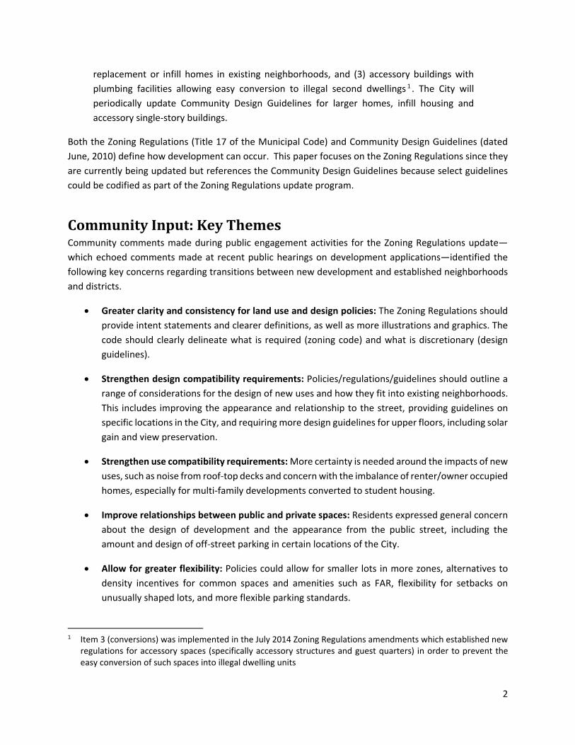
Nonspecific housing types: Currently, the Zoning Regulations allow a high degree of flexibility
for residential uses in nonresidential zones (see Table 1 below). However, the Regulations could
list more specific mid‐range housing types that can provide transition between higher and lower
intensities. These could include attached townhomes, multiplexes, courtyard or garden
apartments, and townhomes. Also, single‐family dwellings are permitted in the densest
residential zones, which may be better suited for medium‐ to higher‐density housing types.
Table 1: Zones Permitting Residential Development
Land Use Type Residential Zoning Nonresidential Zoning
R‐1 R‐2 R‐3 R‐4 O C‐N C‐R C‐D
High‐Occupancy Residential Use
D D
Multi‐Family Dwellings
A A A A D D
Mixed Use A A A A
Single‐Family Dwellings
A A A A A D D
Accessory Dwelling Units (ADUs)
A A A A A
Key: A=Allowed, D=Director approval Note: The High‐Occupancy Residential Use classification may be modified as part of the Zoning Regulations update to ensure consistency with fair housing laws.
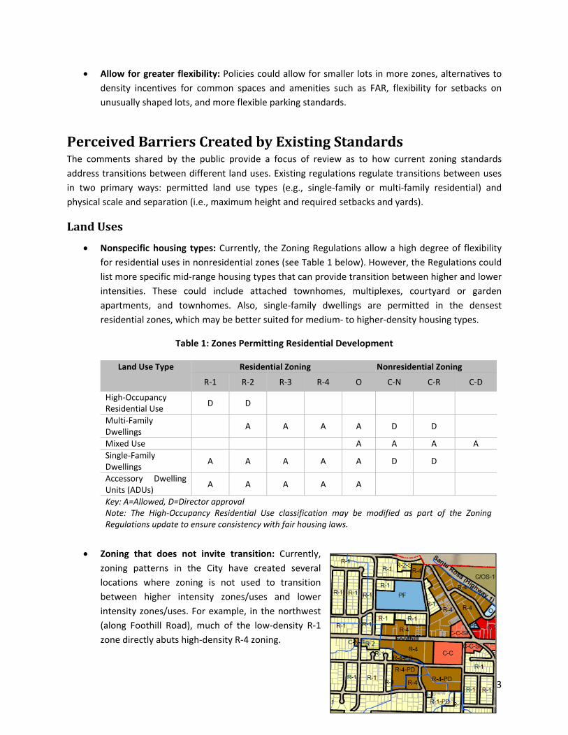
Zoning that does not invite transition: Currently,
zoning patterns in the City have created several
locations where zoning is not used to transition
between higher intensity zones/uses and lower
intensity zones/uses. For example, in the northwest
(along Foothill Road), much of the low‐density R‐1
zone directly abuts high‐density R‐4 zoning.
4
typically provide additional direction for the design of individual developments, current guidelines have minimal guidance on mixed-use development, especially for upper-floor uses. The Mixed Use overlay zone has clear goals and is intended to align with the unique context of adjacent uses. However, the City may be better served by having two or more mixed-use zones that are based on the unique needs and character of specific districts or neighborhoods.
Direction on use conversions: The Office (O) zone currently functions as a mixed-use zone, allowing for a range of residential and nonresidential uses. Yet, limited standards regulate the conversion of residential uses to nonresidential uses in the Office zone, or to allow multifamily housing adjacent to an R-1 or R-2 zone, which has the potential to lead to surprising outcomes for neighboring residents.
Design
Limited variation in design requirements: In zones that allow residential uses, minimum lot sizes all fall within the 5,000- to 6,000-square foot range, with larger lots required in the Retail Commercial (C-R) zone. Similarly, most residential zones have 50-foot minimum lot widths, which limit flexibility in the design of new development to match unique settings, or to encourage a scaled transition between different land use intensities and types. (Specific plans for master-planned developments have addressed this issue by establishing development standards different from the traditional zones. Also, common interest and airspace subdivisions allow for flexible lots sizes.) Maximum heights also have limited variation across the zones.
Table 2: Design Regulations for Zones that Allow Residential Uses (17.24-17.30, 17.34, 17.38, 17.40)
6,000 sf 5,000 sf 5,000 sf 5,000 sf 3,000 sf 5,000 sf 6,000 sf 9,000 sf
Maximum Building Height
25’-35’ 35’ 35’ 35’ 50’-75’ 25’-35’ 35’ 45’
Units/Acre (max.)
7 12 18 24 36 12 12 36
Limited direction for smaller nonresidential developments: Commercial zones have large maximum floor area requirements, including 45,000 square feet in the Neighborhood Commercial zone (C-N) and 60,000 square feet in the C-R zone. However, there are limited standards requiring smaller building footprints that are to scale with residential uses, and some zones (including the Office zone) lack a maximum size requirement.
5
Standardized setbacks regardless of setting: The Zoning Regulations currently prescribe a scaled setback or yard requirement based on building height, with several exceptions that provide limited objective criteria. Also, limited consideration of setbacks is provided based on land use or street type. Furthermore, no guidance is provided as to what should be included in the yard or setback space.
Minimal parking design guidance: The design standards for off-street parking are similar regardless of zone. Parking can be used as an effective transition area between higher- and lower-intensity uses.
IntentandFunctionOverall, the Zoning Regulation provide only a few graphics, illustrations, and precedent photos to convey the intent and design direction. The design guidelines are not regulatory in nature but are used as a basis for approving or denying projects. The guidelines provide several design review criteria that could be codified to provide more certainty to applicants and the public, such as building façade lengths and off-street parking location and design standards.
PotentialTransitionConsiderationsCommunities throughout California and the U.S. similar in scale to San Luis Obispo experience the transition issues of concern locally. Presented here are examples of approaches used both at a district level and more generically citywide. Reference is made both to codified standards and design guidelines, with the recognition that some design guidelines could be adopted as standards (not just suggestions). And although a few form-based approaches are described, the City is not considering a form-based code approach to any area except possibly in Downtown.
Encouraging“MissingMiddle”HousingExisting zoning prescribes standards for single-family housing and multifamily housing, with minimal emphasis on housing types that provide a transition between lower-density detached housing and denser, or multistory multifamily housing. The “missing middle” housing refers to housing largely absent from many communities that provides a medium-density housing type, providing a functional buffer between contrasting land uses. As an example, courtyard housing provides an approach to denser housing without the need for taller buildings. This housing type clusters one- or two-story apartment units around a central courtyard or greenspace shared by residents. The massing of buildings can oftentimes fit the surrounding context of nearby lower-density housing (single-family detached) or even
Figure 2: Courtyard housing, Portland, Oregon
6
stand-alone two-story apartment buildings. The adjacent image shows a development in Portland, Oregon with detached and attached condominiums designed around a common open space that resemble surrounding detached single-family housing.
DevelopingaPerimeterDesignDistrictThe City of Bellevue, Washington adopted a Transition Area Design District that provides a buffer between residential uses in a residential land use district and a land use district which permits development of a higher intensity. The primary function of the district is to incentivize improvements that would serve to provide a transition with established uses, such as underground parking, pitched roof, upper floor step-backs, and others. The standards also prescribe minimum landscaping and setbacks for uses that are adjacent to higher-intensity development.
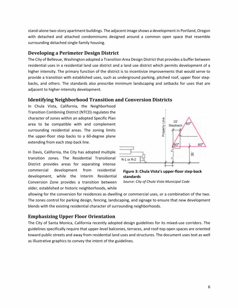
IdentifyingNeighborhoodTransitionandConversionDistrictsIn Chula Vista, California, the Neighborhood Transition Combining District (NTCD) regulates the character of zones within an adopted Specific Plan area to be compatible with and complement surrounding residential areas. The zoning limits the upper-floor step backs to a 60-degree plane extending from each step back line.
In Davis, California, the City has adopted multiple transition zones. The Residential Transitional District provides areas for separating intense commercial development from residential development, while the Interim Residential Conversion Zone provides a transition between older, established or historic neighborhoods, while allowing for the conversion for residences as dwelling or commercial uses, or a combination of the two. The zones control for parking design, fencing, landscaping, and signage to ensure that new development blends with the existing residential character of surrounding neighborhoods.
EmphasizingUpperFloorOrientationThe City of Santa Monica, California recently adopted design guidelines for its mixed-use corridors. The guidelines specifically require that upper-level balconies, terraces, and roof-top open spaces are oriented toward public streets and away from residential land uses and structures. The document uses text as well as illustrative graphics to convey the intent of the guidelines.
Figure 3: Chula Vista’s upper-floor step-back standards Source: City of Chula Vista Municipal Code
7
EmphasizingNeighborhoodContextThe city of Seattle, Washington’s design guidelines for its downtown prioritize the unique local setting of proposed developments. The design guidelines call for developments to respond to a variety of design considerations, including local landmarks, public amenities or institutions, and other unique design elements. The guidelines also require a transition in building bulk, height, and scale through the topographic relationship and gradual or stepped changes in perceived height, bulk, and scale with adjacent zones and uses.
ProvidingCharacteristicsandVisualstoDescribeContextTacoma, Washington uses a Transitional District between commercial or industrial areas and residential areas. Land uses within this zone are characterized by lower traffic generation, shorter operation hours, smaller-scale buildings, and less signage than general commercial areas. The City also has several mixed-use zones that range from a neighborhood scale (45-foot heights) to an urban center (with 75-foot heights). Similarly, the Linden Hills Neighborhood in Minneapolis, Minnesota uses a series of policies and graphics to convey how new and denser development should fit within the context of surrounding residences and lower-density uses.
ConceptsPresentedatJune3,2017WorkshopAt the June 3, 2017 community workshop on the Zoning Regulations update, participants commented on proposed approaches shown on the next two pages for addressing transitions between residential uses.
Figure 6: Linden Hills, Minnesota neighborhood context example Source: Linden Hills Neighborhood
9
10
11
RegulatingBuildingFormbyStreetTypeandImpactAvoidanceIn El Cerrito, California, the City’s San Pablo Avenue Specific Plan outlines a comprehensive and form-based approach to the design, use, and function of the community’s major arterial, San Pablo Avenue, with sensitivities to adjacent residential districts. The Specific Plan uses a context-sensitive design approach by regulating building and street-front design by street and block. The plan provides visual examples of allowable building types, public spaces and sidewalk standards, and relation and design of upper floors based on adjacent residential uses, including regulations to avoid adverse shade and shadow impacts. The regulations are extensive regarding building design approaches along all sides of a building.
ConsiderationsforSanLuisObispoAs the City investigates potential solutions to improving transitioning between higher- and lower-intensity land uses—and in particular, addressing privacy, shading, and similar concerns—the following questions and discussion points can help guide the conversation.
Figure 7: Shade and Shadow Regulations Source: City of El Cerrito, San Pablo Avenue
Specific Plan
12
A new zoning tool consisting of a transition overlay, perimeter district, or various subdistricts could help create functional buffers between higher-intensity uses and lower-density residential uses. These could be applied on location-specific basis. If this is a desired tool, which interface areas are of greatest concern (for example, the area shown in Figure 1)?
Encouraging and better defining housing types with a greater specificity (for example, not just density but building approach) could influence what type of new housing is constructed in interface areas. This approach may even help encourage the so-called “missing middle” housing type for new home ownership opportunities.
Figures 3 and 4 above illustrate required transitions in, respectively, Chula Vista and Santa Monica. Including such graphics will enhance the regulations, should the City decide to require a step-back approach to address edge/transition conditions.
The Zoning Regulations could include direction for the design and location of required off-street parking, including incentives to use well-designed surface parking as a transition between uses.
Are there provisions in the Community Design Guidelines that City staff believes should be codified to support design approaches that work toward suitable transitions?
ConclusionResidents of San Luis Obispo are proud of the city’s historic and cultural heritage, and feel strongly about protecting the unique setting of different neighborhoods. While traditional zoning helps organize the location of different land uses based on function and intensity, the City also relies on the subjective Community Design Guidelines to provide greater detail to produce development that is context sensitive and of long-lasting quality. Recent projects that respond to Land Use Element policy directives have created a sense among some community members that current regulations and guidelines used in tandem do not adequately address edge conditions in some areas of town, particularly adjacent to single-family neighborhoods. Updating the Zoning Regulations to respond to concerns will require: 1) defining the geographic areas of concern and 2) determining and selecting the appropriate regulatory approach for San Luis Obispo. As a subsequent work effort, the City may also consider revising the Community Design Guidelines to address transitions/edge conditions that cannot fully be addressed in a regulatory document.
13
SourcesCity of Bellevue Municipal Code, accessed July 2017: https://www.codepublishing.com/WA/Bellevue/
City of Boise, Downtown Design Guidelines
City of Chula Vista Municipal Code, accessed July 2017: http://www.codepublishing.com/CA/ChulaVista/
City of Davis Municipal Code, accessed July 2017: http://qcode.us/codes/davis/
City of El Cerrito, San Pablo Avenue Specific Plan Form-Based Code
City of Santa Monica Mixed Use Design Guidelines: https://www.smgov.net/departments/pcd/agendas/Planning-Commission/2012/20121128/Draft-Mixed-Use-Design-Guidelines.pdf
City of Seattle Design Guidelines: http://www.seattle.gov/dpd/cs/groups/pan/@pan/documents/web_informational/p2083771.pdf
City of Tacoma Municipal Code, accessed July 2017: http://cms.cityoftacoma.org/Planning/Zoning_booklet_FINAL_2015update.pdf
Courtyard Housing, accessed July 2017: http://www.courtyardhousing.org
Linden Hills Neighborhood Small Area Plan, December 2013, http://www.ci.minneapolis.mn.us/www/groups/public/@cped/documents/webcontent/wcms1p-126733.pdf
ConsultantforthisWhitePaper
MIG, Inc. 537 S. Raymond Avenue, Pasadena, CA 91105 (626) 744-9872 www.migcom.com
14
APPENDIX
Report and Recommendations
Neighborhood Compatibility
Report and Recommendations Neighborhood Compatibility
RESEARCH (CASE STUDIES) ................................................................................................................................. 4
1. COVERAGE AND FLOOR AREA RATIO.......................................................................................................................... 4 2. FLOOR-TO-FLOOR HEIGHT AND SETBACKS .................................................................................................................. 5 3. DESIGN GUIDELINES ............................................................................................................................................... 6 4. DRAWINGS AND PHOTOGRAPHS TO SUPPORT GUIDELINES ............................................................................................. 6 5. OTHER METHODS .................................................................................................................................................. 7
PUBLIC WORKSHOPS .......................................................................................................................................... 7
1. APRIL 6, 2016: PUBLIC WORKSHOP AT TEACH ELEMENTARY SCHOOL ............................................................................ 7 2. JULY 14, 2016: PUBLIC WORKSHOP AT SLO CHURCH OF THE NAZARENE ........................................................................ 8
STUDY SESSIONS ................................................................................................................................................ 8
1. MAY 2, 2016: ARCHITECTURAL REVIEW COMMISSION STUDY SESSION .......................................................................... 8 2. AUGUST 24, 2016: PLANNING COMMISSION STUDY SESSION ....................................................................................... 9
1. UPDATE COMMUNITY DESIGN GUIDELINES ................................................................................................................. 9 2. UPDATE ZONING REGULATIONS .............................................................................................................................. 12 3. CONTINUED DISCUSSION ....................................................................................................................................... 12
Ne
igh
bo
rh
oo
d C
om
pa
tib
ilit
y R
ep
or
t
2
Introduction The purpose of the subject report is to provide background information on the workshops and study sessions which were conducted to receive input and ultimately to obtain direction on the topic of neighborhood compatibility. This report provides access to all pertinent background materials (e.g. staff reports and presentations) and concludes with recommendations for the Community Development Department to consider when moving into the phase of drafting language.
Background
1. Project Initiation
In June of 2015 the City Council deemed earlier implementation of General Plan Land Use Element Program 2.13 a priority and amended the Neighborhood Wellness Work Program to add a work task for staff to move up the implementation timeline for LUE Program 2.13. Staff was directed to explore amendments to the Zoning Regulations, Subdivision Regulations, Community Design Guidelines, or other pertinent documents (or other means) to address neighborhood compatibility. The concern revolved around scale and density of infill projects leading to incompatibility with existing residences in established neighborhoods. Land Use Element Program 2.13: “The City will consider new regulations, for Low-Density (R-1) and Medium-Density Residential (R-2) areas, to require special review for (1) incompatibly large houses, (2) replacement or infill homes in existing neighborhoods, and (3) accessory buildings with plumbing facilities allowing easy conversion to illegal second dwellings1. The City will periodically update Community Design Guidelines for larger homes, infill housing and accessory single-story buildings.”
1 Item 3 (conversions) was implemented in the July 2014 Zoning Regulations amendments which established new
regulations for accessory spaces (specifically accessory structures and guest quarters) in order to prevent the easy conversion of such spaces into illegal dwelling units
Map at right illustrates R-1 zoned properties in light yellow and R-2 zoned properties in dark yellow
Ne
igh
bo
rh
oo
d C
om
pa
tib
ilit
y R
ep
or
t
3
2. Pertinent Background Materials (documents provided in the Appendix)
Appendix A Project Plan
Appendix B Case Studies (Steve Orozco, Long Range Planning)
Appendix C Workshop #1 Materials 4-6-2016 (Teach Elementary School)
Appendix D Workshop #1 Notes
Appendix E ARC Study Session Materials 5-2-2016 (Staff Report, Presentation, Notes)
Appendix F Workshop #2 Materials 7-14-2016 (SLO Naz Church)
Appendix G Workshop #2 Notes
Appendix H PC Study Session Materials 8-24-2016
Existing Regulations
The City’s existing regulations include the Zoning Regulations’ maximum/minimum requirements for the R-1 (Low Density) and R-2 (Medium Density) zones and the Community Design Guidelines.
1. Zoning Regulations The below table provides a summary of the Zoning Regulations’ requirements for the R-1 and R-2 zones. The Zoning Regulations do not include standards for maximum Floor Area Ratio2, nor specific setbacks for upper floors, as is utilized by some of the other communities researched by staff.
Zone Max Density Max
Height Max Coverage Parking Side &
Rear Setbacks Min. Lot Size
R-1 7 du/acre 25 feet 40% of lot area 2 spaces 5' - 10.5' 6,000 sf
R-2 12 du/acre 35 feet 50% of lot area See footnote* 5' - 15' 5,000 sf
*R-2 Zone Parking Requirements: 1.5 spaces for 1st bedroom +.5 spaces for each additional bedroom in a unit
2. Community Design Guidelines (CDG)
2 Floor Area Ratio: The gross floor area of a building or buildings on a lot divided by the lot area.
Ne
igh
bo
rh
oo
d C
om
pa
tib
ilit
y R
ep
or
t
4
Sections that provide guidance for compatible infill residential projects include Chapter 5.3 “Infill Development,” Chapter 5.4 “Multi-Family and Clustered Housing Design,” and Chapter 5.5-C “Additions and Alterations in Older Neighborhoods.” Their contents are text-based and include some of the following guidance:
1. General Principles: Infill projects should be compatible in scale and overall character with the neighborhood.
2. Building Design: Infill structures should incorporate traditional characteristics from the neighborhood
3. Building Height: Height should be consistent with existing structures in the neighborhood and upper floors should be setback from the edge of the first floor.
4. Materials/Colors: Use predominant materials and compatible colors with the neighborhood.
Research (Case Studies)
Staff researched a number of communities that have experienced the issue of neighborhood compatibility. Specifically highlighted are the communities of Davis, Modesto, Pasadena, and Sunnyvale who have developed regulations to address the areas of open space, structure location on the site, design, mass and scale, height and setbacks, privacy, materials/colors, and more.
Staff research found that these communities have tried to address neighborhood compatibility from a regulatory basis (e.g. “second floors shall be setback 5 feet from the wall of the first floor”) and/or from a guideline basis (e.g. a “second-story addition should be located away from the front of the house to reduce its prominence”). Specific excerpts from the regulations/guidelines of Davis, Modesto, Pasadena, and Sunnyvale are provided in Appendix B.
The following sections highlight different techniques that have been used to address compatibility:
1. Coverage and Floor Area Ratio
The City of San Luis Obispo has a maximum coverage3 of 40% and 50% in the R-1 and R-2 zones, respectively. The City’s coverage regulation is essentially a limitation on the size of a structures footprint, but does not regulate the square footage of a structure that can fit within that maximum footprint; often leading to two-story stacked floor plans.
Other communities establish a maximum floor area ratio to address the maximum size of a residence. For example, a floor area ratio of 40% would allow a maximum home size of 2,400
3 Coverage: The area of a structure on or above the ground including upper level projections and living areas, as
well as covered or uncovered decks, balconies, porches and similar architectural features expressed as a percentage of the total lot area.
Ne
igh
bo
rh
oo
d C
om
pa
tib
ilit
y R
ep
or
t
5
square feet, including garage square footage (assuming a 6,000 square foot lot size); the ratio can be adjusted for compatibility with the floor area ratio of a given neighborhood.
2. Floor-to-Floor Height and Setbacks
Some communities have established specific regulations for floor heights and upper floor setbacks as a way of addressing compatibility.
(Pasadena) Floor-to-Floor Height Limits. The maximum top plate height of the first story of the main structure shall not exceed ten feet. The maximum top plate height of the second story of the main structure shall not exceed 20 feet.
(Pasadena) Second Story Setbacks. The second story of the main structure, and any portion of the main structure over ten feet in height, shall be set back a minimum of five feet from the existing first floor side walls. Second story additions and any portion of the main structure over ten feet in height shall be set back a minimum of 10 feet from the first-floor front wall.
Example of Existing Regulations: • 6000 square foot lot • 40% Coverage
Example with “Floor Area Ratio”: • 6000 square foot lot • 40% Coverage • FAR of .40 = Max 2,400 sq.ft home size • Results in no second story or reduced
footprint size
Ne
igh
bo
rh
oo
d C
om
pa
tib
ilit
y R
ep
or
t
6
3. Design Guidelines
The City of Modesto (Appendix B) created the “Neighborhood Compatibility Guidelines” to improve compatibility of infill residences. These guidelines are intended to provide clarity to a user by indicating the types of projects that are preferred by the community through additional specificity in their guidelines. For example, some guidelines may indicate that an infill residential structure should “provide a sense of visual continuity with existing structures in the neighborhood”, however, more specificity is added to reduce subjectivity of the guideline; “provide a sense of visual continuity with existing structures in the neighborhood by aligning the front and sides of a new building with other structures in the neighborhood”.
Additionally, some of the guidelines include:
1. Neighborhood Surveys. Neighborhood surveys to identify neighborhood characteristics (see Appendix B, Sunnyvale, Pages 5 – 8)
2. Definition. A clear definition of a “neighborhood” for compatibility context (see Appendix B, Modesto, Page 3)
3. Goals with Strategies. Guidelines arranged by goals with listed strategies to carry out those goals (see Appendix B, Davis, Page 89)
For additional clarity, the guidelines are often supported by descriptive graphics to illustrate the text, as provided in the
4. Drawings and Photographs to Support Guidelines
Many communities have used drawings and photographs to support the text. The graphics provide callouts and descriptions for additional clarity, some examples are provided below.
(Davis) The primary building face should not exceed the width of a typical single family building in a similar context.
• A single wall plane should not exceed the maximum façade width of a typical residence. If a building is wider overall than those seen typically, divide the large façade into subordinate wall planes that have dimensions similar to those of traditional single family buildings in the neighborhood.
(Sunnyvale) Design second floors to complement first floor forms and minimize their visual impact
• The area of the second floor should not exceed the common standard of the neighborhood.
Do This Not This
Ne
igh
bo
rh
oo
d C
om
pa
tib
ilit
y R
ep
or
t
7
5. Other Methods Other methods of addressing neighborhood compatibility include the following:
1. Overlay Zone/District. Several communities (e.g. Davis, Pasadena) have used overlay zones/districts to establish specific design guidelines or zoning regulations to a given neighborhood.
2. Design Review Threshold. Communities (e.g. Sunnyvale) have established formal design review requirements based on the size of a proposed addition or based on the overall size of the proposed residence.
3. Additional Parking Requirement. The City of Davis requires additional parking spaces once a residence (in their Low Density Zone) proposes five or more bedrooms.
Public Workshops
1. April 6, 2016: Public Workshop at Teach Elementary School Purpose: Obtain feedback and ideas from public Outcome: Notes from workshop On April 6, 2016 staff conducted a Neighborhood Compatibility Workshop at the Teach Elementary/SLO Classical Academy elementary school campus for the purpose of obtaining public feedback and ideas on the subject.
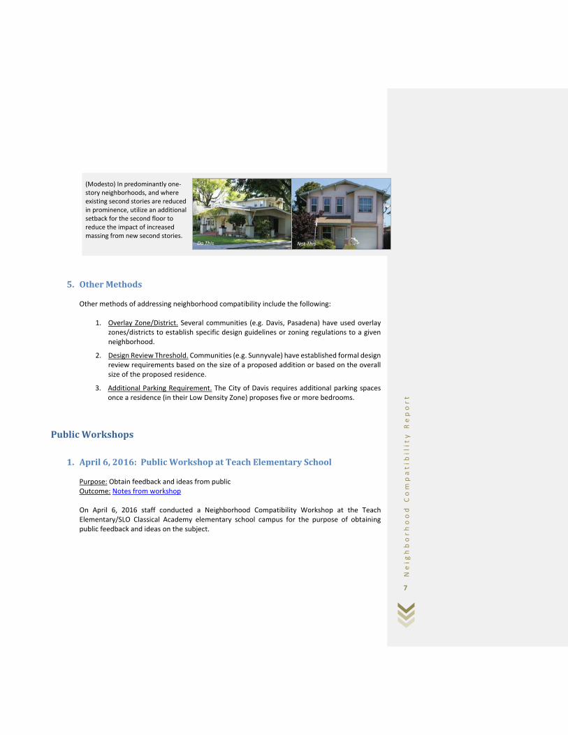
(Modesto) In predominantly one-story neighborhoods, and where existing second stories are reduced in prominence, utilize an additional setback for the second floor to reduce the impact of increased massing from new second stories.
Do This Not This
Ne
igh
bo
rh
oo
d C
om
pa
tib
ilit
y R
ep
or
t
8
The format included a presentation of staff research followed by “break-out sessions” to discuss which approaches (including new ideas) should be used to improve neighborhood compatibility. Each table reported their discussions back to the main group while staff facilitated and took notes on the deliberations; said notes are provided in “Outcome” above.
2. July 14, 2016: Public Workshop at SLO Church of the Nazarene Purpose: Obtain additional public feedback and ideas, obtain feedback on visual survey using Google Earth.
Outcome: Notes from workshop, input on visual survey. On July 14, 2016 staff conducted the second neighborhood compatibility public workshop at the San Luis Obispo Church of the Nazarene for the purpose of obtaining additional public feedback and ideas from interested parties. The format included an update on progress (including the feedback received from the ARC) and a presentation on ways to address neighborhood compatibility. The presentation was followed by an interactive Google Earth photo-survey where participants reviewed infill projects and provided written feedback on whether the built project was “compatible,” “not compatible,” or “close to compatible.” Staff compiled the results of the visual survey which were attached to the Planning Commission staff report and provided in “Outcome” above. The workshop concluded with a general discussion about successful and unsuccessful strategies to address compatibility as well as discussion regarding concerns of incompatible infill homes. Staff took on-screen notes which are provided in “Outcome” above.
Study Sessions
1. May 2, 2016: Architectural Review Commission Study Session Purpose: Review progress, provide feedback, public input Outcome: Eight directional items (same as PC Study Session below)
Ne
igh
bo
rh
oo
d C
om
pa
tib
ilit
y R
ep
or
t
9
On May 2, 2016 the ARC held a study session to review progress, provide feedback, and offer an opportunity for public input on the project. Upon review, the ARC provided several points of feedback which were summarized and confirmed at the end of the hearing. This feedback is provided in “Planning Commission Study Session” below – the Planning Commission supported the same directional items as the Architectural Review Commission.
2. August 24, 2016: Planning Commission Study Session Purpose: Review progress, obtain feedback on strategies to address neighborhood compatibility, obtain public input
Outcome: Seven directional items (same as ARC)
1. Consider a design review threshold 2. Consider using overlay districts 3. Consider using Floor Area Ratio approach 4. Consider requiring specific setback standards for upper floors 5. Consider policy requiring maximum buildable area be a function of average lot size of
properties in a given radius 6. Consider guidelines with goals and supporting strategies 7. Consider use of more specific text supported by graphics
On August 24, 2016 the PC held a study session to review progress, provide feedback, and offer a fourth opportunity for public input. Upon review, the PC supported the same seven directional items as the ARC.
Recommendations As indicated above, the Architectural Review Commission and Planning Commission provided the same list of directional items which are provided below. The following recommendations are intended to assist the Community Development Department in carrying out the remaining research and implementation to comply with ARC and PC direction. In addition, it is important to remember that LUE 2.13 is specific to “incompatibility large houses” and “replacement or infill homes in existing neighborhoods” in the low-density (R-1) and medium-density (R-2) residential areas.
1. Update Community Design Guidelines
As indicated previously in this report, CDG sections that provide guidance for compatible infill residential projects include Chapter 5.3 “Infill Development,” Chapter 5.4 “Multi-Family and Clustered Housing Design,” and Chapter 5.5-C “Additions and Alterations in Older Neighborhoods.”
Ne
igh
bo
rh
oo
d C
om
pa
tib
ilit
y R
ep
or
t
1 0
The existing language within these sections, however, is too broad and does not provide enough clarity of the intent of each guideline. This coupled with a lack of graphical support creates ambiguity. Recommendations:
1. Establish Design Review Threshold (compliant with directional item #1). Update to CDG Chapter 1.2 “When is Design Review Required?”
a. Include a design review threshold that requires design review when the size of an infill home (or total home size with a new addition) exceeds a determined threshold. E.g. ARCMI design review is required when the total home size exceeds the average square footage of homes within a 100 foot radius by 20%. E.g. ARCMI design review is required when an addition is proposed to be 20% or larger than the existing floor area of the structure (including garage). See Sunnyvale “Things to Know” for additional examples. Additional research is required to determine proper threshold.
2. Establish Guidelines with Goals and Supporting Strategies (compliant with directional
item #6) and support the goals/strategies with example graphics (compliant with directional item #7). Update to CDG Chapter 5 specifically Chapters 5.3 “Infill Development,” Chapter 5.4 “Multi-Family and Clustered Housing Design,” and Chapter 5.5-C “Additions and Alterations in Older Neighborhoods.”
a. Goals and Strategy Guidelines. For additional clarity, provide more specificity in the guidelines by updating each applicable section to be arranged with general goals for design and compatibility. Each goal will then be supported by multiple strategies to indicate how to reach the goals. Example:
i. Include language that requires upper story setbacks if such setbacks are
prevalent in the established neighborhood (compliant with directional item #4).
It is not uncommon for infill homes to propose two-story stacked floor plans which appear bulky and more massive than existing homes with setback upper stories. It is recommended that the CDG include language for upper story setbacks to provide flexibility in home design, rather than regulating setbacks through the Zoning Regulations. Proper
Commented [CM1]: Add this document to Sunnyvale Appendix
Ne
igh
bo
rh
oo
d C
om
pa
tib
ilit
y R
ep
or
t
1 1
support from graphics (see 2b below) will clearly illustrate the intent of upper floor setback design.
ii. Note: Review notes from the workshops (see appendix) to see
comments provided by interested parties. Pertinent comments should be addressed in updated CDG language.
b. Graphics. Support the goals/strategies text with graphics to help illustrate the text.
The graphics can be actual example photographs or created images and should include callouts for clarity. Example:
Do This
Not This
Ne
igh
bo
rh
oo
d C
om
pa
tib
ilit
y R
ep
or
t
1 2
2. Update Zoning Regulations
Recommendations: 1. Establish Maximum Floor Area Ratio for R-1 and R-2 zones (compliant with directional
item #3). Although not specifically addressed by LUE 2.13, this effort should apply to all residential zones. Update to Zoning Regulations Section 17.16.030 (Coverage), Chapter 17.24 (Low-Density Residential Zone) and Chapter 17.26 (Medium-Density Residential Zone).
a. Use GIS Data to determine lot sizes and County Assessor Data to determine home sizes in order to calculate existing floor area ratios for R-1 and R-2 zones. Use calculation as basis for establishing maximum FAR requirement.
b. The existing definition of Floor Area Ratio (Zoning Regulations Chapter 17.100) is sufficient.
3. Continued Discussion
The following directional item(s) from the ARC and PC require additional discussion or analysis to determine feasibility.
maximum buildable area be a function of average lot size of properties in a given radius” requires additional analysis to determine feasibility. The policy would be very similar to establishing a maximum floor area ratio (which is already a directional item) and has the potential to create confusion. If the department is interested in pursuing directional item #5 it is suggested that efforts focus on establishing a design guideline for the maximum buildable floor area of a residence that would not be able to exceed a determined percent increase (E.g. 30%) of the average size of homes within a given radius (e.g. 300 feet), rather than focusing on average lot sizes. Another option, that would address potential fluctuations in lot size, is to establish the average Floor Area Ratio of homes within a given radius. A new or remodeled home would not be allowed to exceed a determined percent increase beyond the average FAR of homes within that determined radius. If either of these approaches are pursued the guideline should include language to remove homes/properties from the calculation that deviate significantly from the mean.
2. Directional Item #2. Directional item #2 is to consider using overlay districts or zones. Overlay districts in this application would be to have design guidelines that are particular to an established district(s) within the city. Overlay zones would be a new zoning overlay (amendment to the Zoning Regulations) to establish prescriptive regulations to a sub-area within the city.
Ne
igh
bo
rh
oo
d C
om
pa
tib
ilit
y R
ep
or
t
1 3
It is not recommended that the department pursue overlay zones at this time due to the potential to create non-conformities. Following the above recommendations will address the issue of incompatibility while still allowing flexibility in design. Overlay zones may be pursued at a later time if desired. Establishing overlay districts is also not recommended at this time. Discussion at workshops and with the ARC/PC focused on performing neighborhood surveys to document neighborhood characteristics of each district and then establishing guidelines for each overlay district. As noted, following the above recommendations will address the issue of incompatibility from a global perspective without requiring the resources to establish overlay districts. In addition, proper training on the new design guidelines for planning staff will ensure they have a deep understanding of the guidelines and strong ability to communicate the principles to designers and properly shape projects. Additional support could be provided by working with neighborhood groups to document the general characteristics of pertinent neighborhoods. If the department is interested in pursuing overlay districts it is recommended that a consultant with specific related experience is hired to lead the effort (see City of Davis Design Guidelines in the Appendix).


![Holographic Quantum Phase Transitions - UvA · description). A naive extension of Landau’s theory of phase transitions, due to [50, 61], uses a time-dependent order parameter to](https://static.documents.pub/doc/80x56/5f0c13fd7e708231d433a26e/holographic-quantum-phase-transitions-uva-description-a-naive-extension-of-landauas.jpg)


