7 6 . t) .M6 IVl54 T979 Cannon River Resource Analysis Wi Id and Scenic Rivers Program Minnesota Department of Natural Resources April 1979 This document is made available electronically by the Minnesota Legislative Reference Library as part of an ongoing digital archiving project. http://www.leg.state.mn.us/lrl/lrl.asp (Funding for document digitization was provided, in part, by a grant from the Minnesota Historical & Cultural Heritage Program.)
Transcript
7 6 . t) .M6 IVl54 T979
Cannon River Resource Analysis
Wi Id and Scenic Rivers Program
Minnesota Department of Natural Resources
April 1979
This document is made available electronically by the Minnesota Legislative Reference Library as part of an ongoing digital archiving project. http://www.leg.state.mn.us/lrl/lrl.asp (Funding for document digitization was provided, in part, by a grant from the Minnesota Historical & Cultural Heritage Program.)
This resource analysis of the Cannon River was prepared by the Rivers Section and the Bureau of Engineering.
Rivers Section
Paul Swenson, supervisor Jane Harper, rivers project leader Steve Kirch, rivers project coordinator Linda Watson, editor Kathy Brandl, assistant editor Ellen Herman and James Sogaard, researchers Sherry Lee Nunnelee, word processor technician
Bureau of Engineering
Roger Liska, graphics supervisor Tim Latourelle, draftsman Brian Conway, graphic art specialist
Photo Credits
Page 6, rivers section staff. Pages 7 and 10, Walt Wettschreck. Pages 13 and 20, Chuck Wechsler, MDNR. Page 15, Ted Hammond, MDNR. Page 18, Leonard Lee Rue III. Page 28, Gary Bistram.
Tabk of contents ____________________ __ Introduction 3 Recreation 22
Study conclusions 5 Population 24-
Archaeology 24-
The river History 26
Geology and watershed 8
Landform and soils 9 Appendix
Water quality 9 The wild and scenic rivers act 32
Vegetation 11 NR 78-81 35
Wildlife 15 Sample scenic easement contract 4-6
Fish 20 Bibliography 4-7
2
Introduction ____________ _ This resource analysis for the Cannon River shows that the
river possesses the outstanding scenic, recreational, natural, historical, scientific and similar values necessary to qualify it for inclusion in the Minnesota wild and scenic rivers system. A separate booklet, entitled A Management Proposal for the Cannon River, explains the methods the Department of Natural Resources (DNR) proposes to protect the river.
The wild and scenic rivers program
In 1973 the state legislature recognized that the state's outstanding rivers--rivers such as the Cannon--should be safeguarded for the benefit of present and future generations of Minnesotans. The legislature passed the wild and scenic rivers act (Minnesota Statutes, Sections 104.31-104.40) to "preserve and protect" Minnesota rivers that exhibit "outstanding scenic, recreational, natural, historical, scientific and similar values." (See appendix for complete text.)
The act is not meant to restore rivers and river lands to wilderness, but is meant to prevent the damage to exceptional rivers that can be caused by uncontrolled development and recreational overuse. To protect rivers, the act prescribes local zoning, land and scenic easement acquisition from willing sellers and recreation management.
There are now five rivers in the Minnesota wild and scenic rivers system: the Kettle River in Pine county, designated in 197 5; the Mississippi River from St. Cloud to Anoka (1976); the North Fork of the Crow River in Meeker County (1976); the Minnesota River from Lac qui Parle to Franklin (1977); and the Rum River from Lake Ogechie to Anoka (1978).
There are six other river segments under consideration for possible inclusion in the system: the Cloquet River, the St. Louis River, the Snake River, the Minnesota River from Franklin to Le Sueur, the Cannon River from Faribault to the Mississippi, and the North Fork of the Crow River in Wright and Hennepin counties.
3
The wild and scenic rivers act requires the preparation of a management plan before a river can be designated as part of the wild and scenic rivers system. Management provisions for a state wild and scenic river must for the most part meet standards contained in the Statewide Standards and Criteria for the Minnesota Wild and Scenic Rivers System (Minnesota Regulations NR 78-81, in appendix). However, these standards may be modified to take into account special characteristics of the river under consideration.
A preliminary management proposal for the Cannon River has been prepared by DNR Rivers Section staff after a study of the river through field surveys, books, reports and meetings with an advisory committee composed of area residents. A copy of the proposal accompanies this resource analysis. Additional copies of both documents are available from the Rivers Section, Department of Natural Resources, Box 10 Centennial Office Building, St. Paul, MN 55155 (612-296-6784).
The management proposal will be presented to concerned citizens through a series of public meetings in towns near the river. During the meetings, area residents and other interested persons may examine the proposal, ask questions and make recommendations. The proposal will be amended if suggestions made at these meetings indicate that changes are necessary.
Area residents and others will also have a chance to debate the merits of the management proposal at public hearings conducted by a representative of the state Office of Hearing Examiners. The hearing examiner will write his findings and make a recommendation to the commissioner of natural resources, who then will decide whether to include the river in the wild and scenic rivers sytem.
If the Cannon is designated a wild and scenic river, the rules and regulations section of the management proposal (NR 2900) will carry the force of law and will be adopted and administered by local governments along the river.
CANNON RIVER LOCATION MAP - STUDY AREA SCALE: 1" = 5 miles
4
Mpls.-St.Paul 0
~~c~~~m __________ _ The DNR has determined that the Cannon River exhibits
those outstanding qualities--scenic, recreational, historical, scientific and natural--that qualify the river, from Faribault to its confluence with the Mississippi River, for protection under the wild and scenic rivers act.
Scenic
The Cannon begins in a lake region of glacial drift and moraines. The river winds through a valley of rolling plains, limestone and sandstone cliffs and gentle bluffs, meeting the Mississippi in a broad, marshy floodplain.
Cornfields and grassy meadows pasturing cattle sometimes border the river. Fence posts, a farmhouse, barn or silo break the flat horizon. A soft agrarian scent steals one's attention.
In other areas, jutting, steep rock ledges and cliffs curb the river's flow. Swallows nest in cavities hollowed in the weathered stone walls.
On its journey to the Mississippi the Cannon flows through lush stretches of river bottom forest. Virginia creeper and wild grape coil around trunks and tug insistently at branches. In the spring, flowering basswoods exude a provocative scent. Summer's sweetness colors and weights the branches of wild berry thickets.
As the river rounds a bend below Welch, its corridor opens to an upward view of a scantily covered bluff. In autumn, the sun warms the grassy exposure and enhances the brilliance of the bluff's aspen yellow and sumac red.
In its sometimes dramatic, sometimes subtle scenery, the Cannon River valley shares in Minnesota's fragile wealth of natural beauty.
Historical
The Cannon's history is as colorful as its scenery. The river valley attracted adventurers, opportunists, dreamers and robbers.
The river first offered transportation--to the Indians who lived along its banks and to the fur traders who took advantage of the valley's abundance of wildlife.
5
The westward tide of American expansion brought settlers enticed by reports of fertile land and dense stands of hardwoods. The forests fell to the young, timber-hungry region when development of the railroad brought improved shipping facilities. The settlers harnessed the river to power sawmills in prosperous riverside communities. But the timber harvest far outstripped the annual growth and the supply rapidly dwindled.
Removal of the forests opened the land for cultivation. Soon wheat fields dominated the landscape and idle sawmills were converted to grist mills. By the late 1800s the Cannon River valley was producing flour of a quality unsurpassed in the nation. But this era too came to an end, as soil exhaustion and insects caused repeated wheat failures.
The railroads, which had once aided the settlers' prosperity, now enabled the concentration of milling in the Twin Cities and gave the metropolitan mills access to the wheat fields of the west. The Cannon River valley ceased to be a milling center; remnants of abandoned grist mills may still be seen along the river's banks.
Today, with the development of modern farming techniques, the river valley has re-established its prominence in Minnesota agriculture.
Scientific and Natural
According to the state archaeologist, the Cannon River valley is one of Minnesota's most important archaeological areas. Using information gathered from burial mounds and village sites, archaeologists have pieced together a picture of life here in prehistoric times.
By 1000 A.O. the area near the junction of the Cannon and Mississippi rivers was a major center of Indian life. This Oneota Indian Cljlture was probably the closest prehistoric Minnesota people "came to an urban society. The Oneota lived in large villages on the river terraces, cleared and cultivated land in the river bottoms, hunted and fished in the river valley.
Vast numbers of archaeological sites have already been lost
to cultivation and construction, yet much remains to be learned about this ancestral American culture.
The variety of plant communities in the river valley are an important natural feature. Along the river bottomlands, many of the original plant species have survived two centuries of settlement. Remnants of plant communities that once covered extensive areas of Minnesota can be found elsewhere in the valley. Several rare or protected plant species, including the Minnesota trout-lily and the prairie bush-clover, also grow on the Cannon's banks.
Recreational
The Cannon River valley provides an ideal setting for a variety of recreational pursuits. Hunters may encounter
6
many different game species, including white-tailed deer, mink, muskrat, red and gray fox and beaver. Lucky anglers can catch such game fish as walleye, sauger, largemouth and smallmouth bass, white bass and northern pike.
The valley's scenic beauty attracts canoeists and hikers, and offers a natural studio to the outdoor photographer. Several recreational sites are located on public lands along the river.
To minimize the harm caused by excessive development and overuse of this important resource, proper management is necessary. By working together we can ensure that the qualities that make the Cannon what it is today will not be lost tomorrow.
Ge•~~~r~d~~~~~~~~ Sandstone, limestone and other sedimentary rock form
impressive outcrops along the Cannon River. The gray Platteville Limestone and the white St. Peter Sandstone are found upstream of Dundas. Downstream, between Dundas and Welch, the massive Prairie du Chien Dolomite, the Jordan Sandstone, the St. Lawrence Formation and the Franconia Formation form the river bluffs.
Pleistocene glacial deposits occasionally as deep as 400 feet cover most of the watershed. Among these deposits are the glacial outwash, ground moraine and end moraine of the
'e---..._ Red Wmg
CANNON RIVER WATERSHED FARIBAULT TO MISSISSIPPI RIVER - STUDY AREA
8
Wisconsin period that are found along most of the river. River alluvium -- the silt, sand and gravel deposits left by the river-- often covers the glacial deposits. Bedrock exposures are common for a short stretch north of FaribalJlt and again below the Byllesby Reservoir. Many private wells draw water from glacial deposits, while municipalities tap aquifers found in several different layers of bedrock. Much of the groundwater is untapped. Long-term groundwater decline is nowhere evident. Groundwater in many of the bedrock layers is easily polluted, largely through numerous sinkholes. A sinkhole is a surface depression caused by the collapse of an underground cavity in limestone.
Much of the south-central part of the Cannon River watershed is a glacial till plain that ranges in altitude from 1,100 to 1,200 feet above sea level. End moraines form ridges on the east, west and south borders of the plain. The eastern moraine, which marks the eastern terminus of the Wisconsin glacier, rises to more than 1,300 feet above sea level and forms ridges 50 to 100 feet above the plain.· End moraine ridges in the northwest are less marked, but extend directly north across the river valley.
The Cannon River drops an average of about 4.9 feet per mile in its path to the Mississippi River near Red Wing. The drainage area of the river is 1,462 square miles. The largest tributary is the Straight River, which joins the Cannon at Faribault.
The U.S. Geological Survey, Water Resources Division, gathered flow data from a continuous-record recording station at Welch from 1911 to 1913 and from 1931 to 1970. The station is now used only to measure crest stages. The drainage area at the Welch station is about 1,320 square miles.
The Cannon River responds quite dramatically to rain, although the lakes, swamps and groundwater reservoirs in the watershed maintain the river's flow during times of no rain. Peak flows usually occur during spring runoff in early April. The maximum discharge recorded at the Welch station is 36,100 cubic feet per second. The minimum discharge is 2.5 c.f.s. Average discharge is 490 c.f.s.
Landform and soils ________ _ A consideration of landform and soils is essential to sound
land use planning. Each landform and soil type presents particular problems and potentials for development, agriculture and other land uses.
The Cannon River valley is generally characterized by level to gently sloping uplands, steep valley slopes and bottomlands prone to flooding.
The Cannon's floodplain (bottomland) is generally unsuitable for commercial or residential development. It is variably suited for agricultural cultivation, permanent pasture, hay, woodlands and wildlife habitat. The low fertility and low water retention capacity of certain bottomland soils (for example, the Estherville soils) restricts their suitability for agricultural production.
Three basic landform/soil types are found on the bottomlands of the Cannon River valley. Closest to the river are alluvial lands subject to frequent flooding, showing little soil formation and generally unsuitable for agricultural crops. West of Cannon Falls on the higher bottomlands are soils of the Colo-Estherville-Waukegan association. This association
is composed of poorly to excessively drained loams of medium to coarse texture. East of Cannon Falls the Marsh-McPaulRadford association can be found. It is characterized by depressional, very poorly drained marshes and nearly level, moderately well to poorly drained medium-textured soils.
The uplands encompass two basic landforms: generally level toplands and steep valley walls. Four primary soil associations occur both on the toplands and valley walls. The Lester-Hayden-Le Sueur and Ostrander-Maxfield-Klinger associations are found west of Cannon Falls; east of Cannon Falls are the Seaton-Racine-Marlean and Timula-Frontenac associations. These associations contain well to poorly drained loams formed in glacial tills, loess, very recent alluvium and bedrock residuum.
Closest to the river these soil associations occur on steep to very steep valley walls, where they are often excessively drained and prone to drought, very rapid runoff and erosion. The valley walls are unsuitable for development, agricultural crops or heavy grazing.
Water qualitY------------Wi3,ter quality of the Cannon River from Faribault to Red
Wing is good to fair. It is suitable for most wildlife and recreation.
The Cannon River exceeds the maximum fecal coliform count set by the Minnesota Pollution Control Agency (PCA). The river's water quality meets most other PCA standards.
The PCA has classified the Cannon as a 2B river. A 2B river is defined in this way:
"The quality of this class of the intrastate waters of the
9
state shall be such as to permit the propagation and maintenance of cool- or warm-water sport or commercial fishing and Be suitable for aquatic recreation of all kinds, including bathing, for which the waters may be usable." The PCA classification is a goal and is not meant to reflect
the present water quality. The PCA operated two water quality testing sites on the
Cannon River until November 1977, when both were discontinued. The sites were at State Highway 56 near
Randolph (river mile 31.6) and at U.S. Highway 61 west of Red Wing (river mile 7.1). The Randolph site began operation in 1974. The other site was used from 1963 to 1965 and from 1972. Monthly samples were taken at both sites. At these stations the fecal coliform count violated PCA standards in more than one-half of the samples taken.
PCA standards for a 2B river set a limit of 200 fecal coliforms per 100 milliliters of water. The mean coliform count for the station at U.S. Highway 61 was 2,095.95 per 100 milliliters. The mean coliform count of the Randolph samples was 8,513.16 per 100 milliliters.
Fecal coliforms are bacteria found in the intestines of warm-blooded animals. High fecal coliform counts may indicate the presence of pathogenic organisms that cause skin irritations and intestinal diseases.
Fecal coliforms usually enter the . river in large numbers through effluent from polluted runoff and deficient sewage treatment plants and septic systems.
The fecal coliform count in the Cannon is four to eight times greater during high water than in low water, an indication that runoff contains significant amounts of manure.
Faribault's present sewage treatment plant, constructed in 1965, discharges into the Straight River a short distance upstream from its junction with the Cannon. The plant's discharge exceeds PCA limits for biochemical oxygen demand and total suspended solids for secondary treatment plants. Faribault is now upgrading its plant to meet PCA standards.
Dundas has no sewage treatment facility and is served by individual septic systems, which do not work well in the soil and bedrock of this area. Raw effluent reaches the _water table and the river through poor soils or fissures in bedrock. Some systems drain through pipes leading directly to the river.
The Northfield sewage plant, built in 19 58 and upgraded in 1966, discharges into the Cannon. Standards for secondary treatment plants are not being met. Effluent quality will worsen as population increases. Northfield has begun to improve its plant and is meeting interim standards required by the PCA. Dundas may be included in the Northfield system.
The Cannon Falls plant, built in 1964, will have to be
10
improved to meet PCA effluent standards. Welch township is served by individual septic tanks which
discharge into the Cannon by a common drain tile.
Vegetation ____________ _
Before white settlement the Cannon River between Faribault and Red Wing flowed through three major types of vegetation: the "Big Woods," tall-grass prairie and river bottom forest. Of these three, only the river bottom forest remains essentially unchanged.
The Big Woods, a translation of the early French name grand bois, covered much of central and ea~t-central Minnesota. Along the Cannon River, it was found from Faribault to Northfield. The Big Woods was dominated by sugar maple, elm, basswood and red oak. Much of the woods was iost to logging in the 1850s and its fertile soils were converted to farmland. Only a few patches remain today.
Farther east, the river traveled through the tall-grass prame region. Extending from Northfield to Cannon Falls, the prairie supported a rich variety of grasses and herbs such as big bluestem, Indian grass and prairie clover. A few small shrubs and trees such as wild roses and wolf berry also grew here. Because the prairie depended on periodic fires to maintain itself, it has been nearly eradicated through fire prevention practices and agriculture.
The rich river bottom forest grew on the floodplain from west of Welch to the.Cannon's mouth at the Mississippi. This forest was similar to the Big Woods except for such species as cottonwood, ash, box elder, willow, soft maple and hackberry. Most of this plant community remains today. With the establishment of fire controls it has spread westward into the region that was formerly prairie.
Oak openings and aspen-oak lands also were found in scattered areas along the Cannon. Sparsely wooded lands with small stands of oak or hickory were characteristic of the oak openings. The aspen-oak lands contained dense young stands of quaking and bigtooth aspen. Oaks, elms, ash and basswood were also present. Both of these vegetative types were fire dependent and, therefore, were lost to fire control practices. Vegetation was also lost to cultivation and development.
11
Along the river bottomlands, the plant species of two centuries ago are still present today. American elm, green ash and soft maple are frequently observed species of trees. Other trees found near the river include cottonwood, box elder, black walnut, butternut, bitternut, red oak and basswood. The undergrowth includes red osier dogwood, wild black currant, gooseberry and red raspberry. Virginia creeper and wild grape are also common.
The warmer, drier south-facing bluffs of the Cannon host such plant species as sumac, red cedar, box elder, slippery elm, hackberry, wild plum, prickly ash, quaking aspen, bittersweet, and burr and red oak.
The so-called "goat prairies" are found on the steeper south-facing bluffs. Resembling the tall-grass prairies, they are in fact unique assemblages of plants from the tall-grass prairies, the sand plains and the more westerly short-grass prairies. Dependent on periodic fires for maintenance, the goat prairies have been reduced by the invasion of juniper, aspen, smooth sumac and prickly ash. Several plants found here are compass plant, silky aster, blazing star, nodding ladies tress and Indian grass.
Along the cooler, wetter north-facing slopes are sugar maple, red oak, paper birch and ironwood.
Two plant species along the Cannon River are rare not only in Minnesota but in all of North America. They are the Minnesota trout-lily (Er;¥thronium propullans), a small spring wildflower of the lily family, and the prairie bush-clover (Lespedeza leptostachya), a member of the legume, or pea, family. The prairie bush-clover has been found in Cottonwood, Crow Wing and Goodhue counties. It also grows in Illinois, Wisconsin and Iowa, but is always rare and local.
Many more plants along the Cannon River are rare in Minnesota, although they may be common locally. The rare plants list presented here has been compiled from the species collection at the University of Minnesota herbarium.
Grass family -- Gramineae f es cue grass-- Festuca paradoxa District of Columbia panic grass-- P3.nicum columbianum woodland speargrass-- Poa nemoralis var. interior
Spu~ge family -- Euphorbiaceae six-angled spurge-- Euphorbia hexagona
Gentian family -- Gentianaceae white gentian-- Gentiana flavida closed gentian--- Gentiana Andrewsii var. Andrewsii closed gentian-- Gentiana Andrewsii var. dokatica fringed gentian-- Gentiana crinita stiff gentian-- Gentiana guinquefolia var. occidentalis
Mint family -- Labiatae many colored skullcap-- Scutellaria ova ta var. versicolor
Barberry family - Berberidaceae May-apple- Podophyllum peltatum
Honeysuckle family - Caprifoliaceae· grape honeysuckle-- Lonicera prolif era
Bluebell, family -- Campanulaceae cardinal flower-- Lobelia Cardinalis
Loosestrife family - Lythraceae scar let ammannia-- Ammannia coccinea
Water-lily family - Nymphaeaceae water chinquapin-- Nelumbo pentapetala .
Plantain family - Plantaginaceae bracted plantain-- Plantago ar istata
Buckwheat family -- Polygonaceae . erect knotweed-- Polygonum erectum
Rose family - Rosaceae :tree Junebeqy- Amelanchier arborea · alder-le~ved Juneberry-- Amelanchier alnifolia Nicollet's cinquefoil-- Potentilla Nicolletii mild rose-- Rosa blanda f. carpohispida
Madder family - Rubiaceae buttonbush- Cephalanthus occidentalis
Figwort family - Scrophulariaceae carpenter1s square-- Scrophularia marilandica
Vine family - Vitaceae · · five-leaved Virginia creeper-- Parthenocissus gulnguefolia
13
11 'I Ii
Frequetitly···•observed River bottomfandst
Arn erican elm ~· · Ulrrius americana green ash.'""...;· Ftaxinu;s pennsylvanica var. subintegerr ima soft maple _...; Acer..saccharinum cottonwood .,.,:.; Poptilus deltoides box elder -- Acer Negundo black walnut. -- Juglans nigra butternut -- Juglans cinerea bitternut -- Carya cordiformis red oak -- Quercus rubra basswood...;_ Tilia americana red osier· dogwood -- Cornus stolonifera wild black currant -- Ribes americanum gooseberry - Ribes hirtellum red raspberry -- Rubus strigosus virginia creeper -- Parthenocissus inserta wild grape -- Vitis spp. poison ivy -- Rhus radicans stinging nettle -- Urtica dioica wood nettle - Boehmeria cylindrica
North-facing slopes:
sugar maple - Acer saccharum red oak -- Quercus rubra paper brich -- Betula papyrifera ironwood -- Ostrya virginiana
14
South..-.facing slopes:
staghorn sumac - Rhus typhina red cedar - Juniperus virginiana box. elder - Acer· Neg undo slippery elm -- Ulrnus rubra hackberry-- Celtis occidentalis wlld plum .;.... Prunus americana prickly ash -- Xanthoxylum americanum quaking aspen -- Populus tremuloides bittersweet -- Celastrus scandens burr oak - Quercus macrocarpa red oak -- Quercus rubra
Goat prairies:
compass plant -- Silphium laciniatum silky aster -- Aster sericeus blazing star -- Liatris spp. nodding ladies tress -- Spiranthes cernua Indian grass -- Sorghastrum nutans white prairie clover -- Petalostemum candidum purple prairie clover - Petalostemum purpureum mountain mint -- Pycnanthemum spp. big bluestem -- Andropogon Gerardi bastard toadflax -- Comandra Richardsiana flowering spurge -- Euphorbia corollata pasque flower -- Anemone patens var. Wolfgangiana
Wildlife ___________ _ The Cannon River valley provides habitat for a wide
variety of wildlife. In addition to the woods, prairie, wetlands and croplands in the valley, rock outcrops, springs, farm buildings, bridges and cutbanks provide habitats attractive to some species.
The big brown bat, for example, is especially fond of barns. The kingfisher, bank swallow, rough-winged swallow, mink, weasel and otter all use cutbanks for nesting and denning places. Cliff swallows and phoebes use bridges and rock cliffs for nesting. Small woodland ponds are attractive mating places for frogs.
Twenty-six species of amphibians and reptiles are known or expected to be common along the Cannon River. Among them is the mud puppy, the largest salamander in Minnesota and the only one that regularly retains its larval state throughout life. The once abundant leopard frog, recently reduced in numbers, perhaps by disease or pesticides, is also found here. The venomous timber rattlesnake inhabits rocky bluffs above the river east of Cannon Falls.
Species reported along the Cannon but rare in Minnesota include the wood turtle, Blanding's turtle, map turtle and massasauga rattlesnake. All are at or near the northwestern extreme of their ranges. Other species observed occasionally include the cricket frog, six-lined racer, false map turtle, pickerel frog and brown soft-shelled turtle.
More than l 00 species of birds are known or expected to breed regularly along the Cannon. Twenty-two other species, rare, irreguar or reduced in numbers, may breed here.
A breeding colony of about 50 pairs of great ·blue herons was observed recently along the river. Other noteworthy species are the pileated woodpecker, whip-poor-will, redtailed hawk, barred owl and great horned owl. Ospreys fish the river during migration, and bald eagles winter in the vicinity.
Game birds found in the area include the mallard, gadwall, pintail, green-winged teal, blue-winged teal, redhead, wood duck, ruffed grouse, bobwhite, ring-necked pheasant, gray (Hungarian) partridge, snipe, woodcock, rail and coot.
Thirty-six native species of mammals are known to be or
15
are expected to be common along the Cannon. These include the spotted skunk, whose numbers have recently declined, perhaps because of rabies. There are reports of bobcats, formerly very common in southeastern Minnesota, but decimated by trapping, hunting and loss of habitat. Otters, once common throughout the state but also decimated, are probably present in small numbers. The coyote, fairly common in northern Minnesota, is rare along the Cannon.
Although the distribution of some small mammals has not been fully researched and reported, a number of these species are expected to be found along the Cannon because of habitat conditions. These include the pine vole, rock vole, pocket mouse, harvest mouse and least weasel.
Game species present in the river valley include the cottontail rabbit, gray and fox squirrel, raccoon, red and gray fox, mink, muskrat, beaver and white-tailed deer.
Amphibians and reptiles Species· considered regionally rare, decimated or irregular in occurrence are indicated by an asterisk (*).
mud puppy -- . Necturus maculosus common newt -- Notophthalmus viridescens tiger salamanqer -- Ambystoma tigrinum American toad ;..-Bufo americanus *cricket frog-Acriscrepitans swarflp tree. frog-~.Pseudacris nigrita gray tree frog - Hy la yersicolor gray tree frog ,-- •Hy la chrysoscelis green frog -- Rana clamitans leopard frog,_,_ Rana pipiens *pickerelf rog -~ Rana palustris, )\'oqd frog,..... Rana sylvatica blac;k,_banded skink ... _ • Eumeces septeritrionalis *six-lined racer -- Cnemidophorusse.xlineatus smooth green snake.·---. Opheodrys. ven)alis f.ox snake --Elaphe vulpina hognosed sn~ke . .-, ..• }ieterodon contortix
common snipe spotted sandpiper Forster's tern black tern rock dove mourning dove yellow-billed cuckoo black-billed cuckoo screech owl great horned owl barred owl *short-eared owl whip-poor-will common nighthawk chimney swift ruby-throated hummingbird belted kingfisher common flicker pileated woodpecker red-bellied woodpecker , red ... headed woodpecker yellow-bellied sapsucker hairy woodpecker downy woodpecker yellowthroat yellow-breasted chat American redstart house sparrow
8T
Spe<::ies eor1sideredreglonally rare, dedrnated of.··.irregular<iri occurrence are indicated.by a.l"I asterisk·.(*).
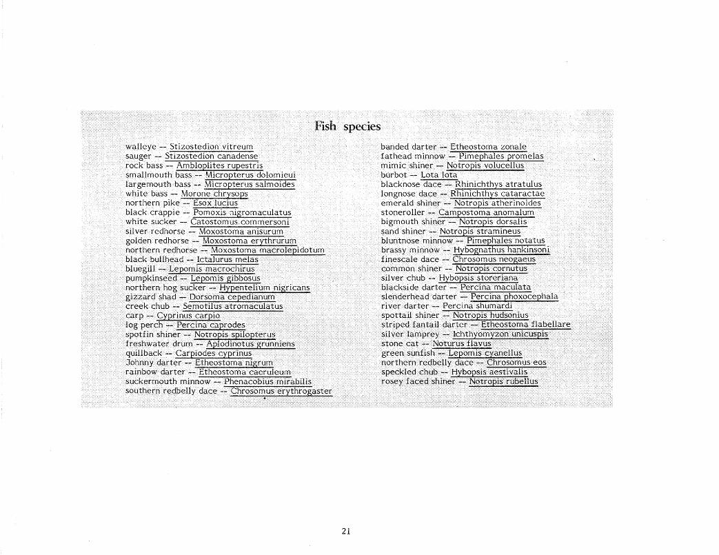
FishL...___ ____________ _ Because of its generally good water quality, the Cannon
River supports a wide variety of fish life, including several popular game and pan fish. Fish frequently travel from the Mississippi up the Cannon to the Welch Dam; this area is reported to be a good fishing spot.
There are about 50 fish species that are known residents of the Cannon. Such sought-after game fish as walleye, sauger, rock bass, smallmouth bass, largemouth bass, white bass, northern pike and black crappie are found here. Other fish harbored in the Cannon include black bullheads, bluegills, pumpkinseeds, suckers, redhorses and carp. A more complete list of species is presented at the end of this section.
There are a few fish found in the Cannon that are relatively uncommon in Minnesota. The suckermouth minnow, for example, is found only in the southeastern
20
counties of the state. The southern redbelly dace is found only in southern tributaries of the Mississippi River and reaches its northernmost range in the Cannon. A recent find in the Cannon is the burbot, rare in this part of the state.
The banded darter, at one time thought to be rare, has since been found to be abundant in southern Minnesota. In the Cannon it is the most common darter.
Other fish in the Cannon, though common, are nevertheless interesting. The fathead minnow, for example, is both a good bait minnow and useful in mosquito control. The mimic shiner is an important forage fish for walleye, and its presence here helps maintain the walleye population. The presence of redhorse species in the Cannon indicates that its water quality is good. These fish are some of the first to succumb when water becomes polluted or continuously turbid.
Electro-fishing surveys of the Cannon River were conducted by the DNR in May and July 1977. Electro-fishing is a technique used to temporarily immobilize fish within a small area by introducing an electric field into the water. Fish then can be netted, identified, weighed, measured and returned to the water unharmed.
The May survey was conducted in two short segments of the river. In Section 1, the 1.5 miles above the U.S. Highway 61 bridge (river mile 8.5-7.0), a total of 114 fish were caught. Of these, 84 percent were rough fish and 15 percent were game fish. Rough fish include carp, sucker, redhorse, buffalo and quillback; game fish include such species as smallmouth bass, largemouth bass, sunfish, walleye, northern pike, channel catfish and white bass. Minnows, bullheads and sheepsheads make up the balance.
In Section 2, the 1.5 miles above the mouth of Trout Brook (river mile 19.5-18.0), 247 fish were sampled; 80 percent were rough fish, 18 percent were game fish and 2 percent were forage fish.
In the July 1977 survey, the 10 riv er miles between the Northfield Dam and the State Highway 56 bridge (river mile 41.6-31.6) were shock~d. Out of the 1,356 fish sampled in this stretch, 86.3 percent were rough fish, 5.0 percent were game fish and 8.7 percent were minnows.
Recreation ______________________________ __ The Cannon River valley's resources lend themselves
naturally to a variety of outdoor activities, including fishing, hunting, canoeing, inner-tubing, camping and hiking.
The Cannon valley and surrounding areas provide excellent habitat for both large and small game. Migratory waterfowl find resting and breeding areas in the many marshes and potholes near Red Wing. The river supports a fair game fish population that includes walleyes, smallmouth bass and sunfish.
The Cannon is popular with canoeists. During the paddling season the water is generally at a level that permits canoeing. The river's moderate current and the absence of
difficult rapids make the river ideal for novice boaters and family outings. The high bluffs and other beautiful scenery in the valley contribute to the river's appeal.
Floating the river in inner tubes is another popular activity on the Cannon, especially near Welch. The Cannon receives heavier tubing use than most other streams in the state. In fact, it is one of the few state rivers where an outfitter caters to inner-tubing.
The natural character of the river valley also encourages camping, hiking, nature observation and photography.
The accompanying table shows the existing public recreational facilities along the Cannon River.
Public recreation facilities River Mile
51.2-47 .4
45.1
Site lndentification
Cannon River Wilderness Area
Dundas City Park
Ownershi_e
Rice County
Vlllage of Dundas
OperationMaintenance
Rice County
22
Facilities
River left: Toilets, picnicshelter, picnic tables, garbage cans, crushed rock parkiJlg.lotand road, designated campsites, fire rings and hiking trails. River·right: Campsites, fire rings and· hiking trails.
Two .baseball diamonds, picnic shelter, picnic tables, garbage cans,. water fountains, toilets, fire grills, campground, canoe access and crushed rock parking lot and road.
Riverside Park Northfield Northfield Covered shelter, picnic tables, water faucets, fire grills, garbage cans, toilets and crushed rock parking lot and road.
32.3- Dakota County Dakota County Dakota County Rest area with no facilities. 32.0 parkland
27 .1 Lake Byllesby Dakota County Dakota County Access and dock about 300 yards access from campsite.
27.0 Lake Byllesby Park Dakota County Dakota County Campground, swim ming beach, drinking water and toilets.
27.0 Goodhue County Goodhue County Goodhue County Boat launch. parkland
25.3- Lower Hannah's Searle's Grain Cannon Falls Picnic shelter, picnic tables, Bend Park Company. 25- toilets, archery range, boat
year lease to access with dock and crushed Cannon Falls. rock road and parking lot.
25.2 Upper Hannah's Cannon Falls Cannon Falls Park benches, picnic tables Bend Park and playground equipment.
25.0 Riverside Park Cannon Falls Cannon Falls Covered shelter (donated by Izaak Walton League), toilets, picnic tables, playground equipment, garbage cans, water fountain and crushed rock road and parking lot. Access is possible, though there is no developed access.
7.0 DNR access DNR DNR Access and parking lot.
23
Population __________________________ __ Trends and projections indicate that the steady increase in
population in the Cannon River area will continue. Tables A, B and C illustrate these trends in the counties, cities and townships near the Cannon River.
TABLE A: Count~ulation Trends.
County .!2ZQ 1976 (est.) % Increase 2000 Projection
More than 2 million Minnesotans live within a two-hour drive of the Cannon River. The population of the seven-county metropolitan area, estimated at 2 million in 1976, is expected to increase to about 2.9 million by 2000. Because of this increase in population and in view of the proximity of the Cannon River to the metropolitan area, recreational use of the river is expected to increase.
Archaeology ___________ _ The Cannon River valley is one of the most important
archaeological areas in Minnesota, according to Christy Caine, state archaeologist and Hamline University professor.
By 1000 A.O. the area near the junction of the Cannon and Mississippi rivers was a major center of prehistoric Indian
24
life. This Oneota .Indian culture, apparently related to the great Middle Mississippian center at Cahokia, Illinois, was probably the closest prehistoric Minnesota people came to an urban society.
Earlier prehistoric cultures of the Middle Woodland period
antedate the Oneota and numbers of the burial mounds of the region can be attributed to these forerunners. Pre-pottery cultures of the Archaic and Paleo-Indian periods also exist in the Cannon River area. Although none of the archaeological sites of these very early times have been excavated, surface collections of artifacts from the uplands bordering the river valley demonstrate that such sites do exist.
The Cannon River was part of an east-west route that linked the peoples of the eastern rivers with those of the western plains. Instead of ascending the Mississippi to its junction with the Minnesota River and continuing west up the Minnesota, it was more common to take the Cannon westward and portage from its upper reaches to the Minnesota.
About 25 burial mound concentrations and five village sites have been recorded along the Cannon River. Thousands of burial mounds, once common along ridgetops and high river terraces, have been lost to cultivation and construction. But archaeologists, excavating mounds and village sites that escaped destruction, have pieced together a picture of life in this society.
Two such sites along the Cannon River are the Bryan Village and Fort Sweeney sites. Fort Sweeney, listed in the National Register of Historic Places, is across the Cannon River from Welch. Situated on a high hill overlooking the river valley, the Fort Sweeney site contains 4-1 pits, mounds and other earthworks. Excavation has led archaeologists to believe that this was a burial ground or ceremonial place.
The Bryan Site, a large prehistoric village and burial area, lies on a high terrace immediately south of the Cannon River near Red Wing. A rich deposit of gravel was discovered in this terrace and was leased by the Minnesota State Highway Department. When the gravel was removed from the eastern end of the area, a number of burials were exposed and later investigated by the University of Minnesota. When the topsoil was stripped off land further to the west, a large number of black dirt-filled holes indicating storage pits and
25
the presence of an ancient Indian village were revealed. The site has since been destroyed.
The Oneota people lived in extensive villages housing from 600 to 800 people. At least some residents, as evidenced by the Bryan Site, occupied small, semi-subterranean houses. Sometimes surrounded by a protective wall or palisade, the villages were often located on flat river terraces above the bottomlands. Deep underground storage pits for vegetables were dug throughout the villages.
The Oneota people depended on the cultivation of corn, beans, squash, sunflowers and tobacco. Timbered areas in the river bottoms were cleared and small garden plots planted. Hunting and fishing were still important, however; bison remained a staple food.
The storage pits are of special interest to archaeologists because such pits were often used for village refuse after they were no longer fit for storing vegetables. They therefore of ten contain broken tools, parts of pottery vessels and animal bones and ashes. Small projectile points, scrapers and other unbroken tools were sometimes lost in these pits. Whole pots occasionally were dropped into pits and broken. Consequently, according to one researcher, "archaeological treasures may be found in the midst of prehistoric garbage."
Oneota pottery and stone weapons and tools, such as arrowheads, knives, axes and hide scrapers, have been found at the village sites. Bone tools also were commonly used. A hoe, made of a bison or elk shoulder blade, is one of the most frequently found bone tools. Awls, fish hooks, needles, dice and bracelets of bone were also used in Oneota villages. Shells were usually used as personal ornaments, and sometimes as spoons and dippers.
Oneota cultures are ancestral to many of the historically known Siouan-speaking groups of the Midwest. Tribes such as the Winnebago, Iowa, Missouri and Oto developed from this village farming-bison hunting prehistoric culture.
The Cannon River, winding through the rich farming country of southeastern Minnesota, has played a significant role in the development of this area. First a transportation route for Indians and fur traders, the Cannon later attracted settlers, powering sawmills and grist mills in the prosperous communities on its banks.
French fur traders called the Cannon La Riviere aux Canots, "the river of canoes." Indians and traders frequently hid their canoes near the river's mouth as they set out to hunt in the adjoining prairie lands.
The river's present name, a mispronunciation of the original French, comes from the narratives of explorer Zebulon Pike's expedition in 1805-06. Pike used the name Canoe River when telling of his journey up the Mississippi, and the name Cannon River in the account of his return trip.
According to another explorer, Joseph Nicollet, the Dakota Indians called the Cannon Invan bosndata, or Standing Rock. The name referred to an eroded rock column near the river in Dakota County, later called Castle Rock by white settlers.
One of the first permanent settlers of the Cannon River valley, Alexander Faribault, came as an agent of the American Fur Company in 1826 or 1827. He established a trading post at the Dakota village of Tetonka Tonah, located on what was later to be known as Cannon Lake. During the late 1820s Minnesota was dotted with fur trading posts, most controlled by the American Fur Company. Their business was considerable. In a single year on the Cannon Faribault's trade included 1,100 minks, 2,050 pounds of deerskins, 39,080 muskrats and smaller numbers of buffalo robes, martens, raccoons, lynx, fox and beaver.
Some years after his arrival, impressed with the possibilities for water power at the confluence of the Straight and Cannon rivers, Faribault relocated his trading post here, eventually building the first frame house in Rice County in the town he founded.
For many years Faribault and several other traders were the only white inhabitants of the area. However, with the ratification in 1852 of the Treaty of Mendota with the Dakota Indians,
1 the area was opened for settlement and the era of
26
immigration began. Men such as Faribault and John W. North, the founder of Northfield, set about securing land along the Cannon River not only for town sites, but for dam sites as well.
The Cannon River and its tributaries had several advantages which were widely advertised in Eastern papers to attract settlers: the streams offered power facilities; large level floodplains offered extensive tracts of fertile land; and the uplands offered dense stands of hardwoods interspersed with openings of natural grassland.
The local papers did some advertising as well. An editorial in the Faribault Herald proclaimed the virtues of the Cannon River valley: ---
The rich sandy loam of the valleys of the Cannon and Straight Rivers yields the most abundant crops in turn for little effort. The country is well watered by streams, and wells are easily dug which furnish abundance of pure water at a depth of from 12 to 30 feet ... Beet, rutabaga and onion sown broadcast and harrowed in, yield enormo'usly. Cranberries grow wild; there are groves of plums and wild berries, strawberries which easily can be cultivated. Crab apples, which make excellent sauce and pies, are good baked, and make the very best of jelly, superior to any other and are to be had by the bushel for the picking. Gooseberries grow wild also and our streams are bordered with fine grapes ...
The thousands of acres of maple forest furnish us with sugar and syrup, equal to the best. The sugar cane was tried here last year and succeeded admirably. In fact every needful thing will grow here. Winter wheat and spring wheat is unsurpassed by any.
Game is abundant enough to pay for hunting. Our sharpshooters get deer, and any one that can fire a gun can get plenty of prairie chickens with very little trouble ... Fish are so plentiful and so large that the whole truth would sound like a fish story ... In the spring and fall our lakes are covered with ducks and geese, and our woods during the season are alive with pigeons and partridges. Not much danger of starving.
From reports connected with the military service, Minnesota has the healthiest climate in the United States. The dryness of our atmosphere is especially favorable to persons inclined to lung complaints.
As the influx of immigrants began, the territorial government built roads to accommodate them. Cannon Falls was located on one of the most important of these roads, that which ran from Dubuque, Iowa, to St. Paul. Cannon Falls was a stopping place and a fording place for thousands of immigrants in the 1850s. Their passage through town was complicated by the fact that for many years there was no permanent bridge over the Cannon River. A letter from an early settler, published in 1903 in the Cannon Falls Beacon, recalls the mid-19th century on the river:
One of the greatest trials for us who lived on the north side of the Big Cannon was the lack of a permanent bridge. For many years there were none that would stand the spring freshets and the breaking up of the ice. A kind of ferry was tried, then a pontoon bridge. In the winter we had always a safe bridge, and in summer a ford, but for three or four weeks every spring there would be no way we could safely get to town.
The Cannon River valley's place in the history of American fiction was probably due to Minnesota's (unearned) reputation as a haven for those suffering from lung complaints. Author Edward Eggleston came to southeastern Minnesota in 1856, seeking a cure for a chronic respiratory infection. His book, The Mystery of Metropolisville, is the story of a typical boom town that collapsed when the Panic of 1857 wiped out its false prosperity. The town is modeled on Cannon City, where Eggleston spent his first few weeks in Minnesota.
The effects of the Panic of 1857 were alleviated somewhat in the Cannon River valley by the 1859 ginseng boom in Minnesota. ·
The Chinese demand for wild ginseng root was great- -they looked upon the root 1 as a cure-all tonic. In Minnesota ginseng grew luxuriantly in the Big Woods, a dense hardwood forest dominated by large deciduous trees, particularly sugar maple, basswood, elm and red oak. The eastern edge of the
27
Big Woods ran along the Cannon River through Faribault and Northfield.
In the fall of 1858, advertisements in the Faribault weekly newspapers offering money for ginseng spurred the rush to the woods.
Red Wing also had a short-lived ginseng boom. On June 18, 1859 the Red Wing Sentinel announced under the headline "Ginseng Fever" that "premonitory symptoms of this epidemic, which is raging so extensively in some parts of this State, have made their appearance in our usually healthy community." Within a week the ginseng fever was raging to the point where it threatened to "depopulate" the city. Anyone who could "bear the inconvenience of a hot sun, mosquitoes and woodticks" was advised to go out and dig.
However, by June 29 the boom appeared to be over. The Faribault Central Republican reported that the ginseng trade had fallen off rapidly and the supply was nearly exhausted.
Hides, furs and ginseng root, compact articles of relatively high value for their weight, were the principal exports of the Cannon River area before the opening of railroad service here in the late 1850s. With improved shipping facilities, the exploitation of the Big Woods began and the number of sawmills along the river increased dramatically. The river valley contributed to the extension of the rails across the Dakotas by furnishing ties to lay the tracks. Another large part of the annual cut was shipped to the Twin Cities, where it was used for local building and the manufacture of barrels.
The cut greatly exceeded the annual growth so that the timber supply was rapidly diminished. As the supply dwindled, the market for the ties also lessened because the railroads had completed their greatest period of expansion. Finally, the removal of the forest opened the land for cultivation. Very little of the Big Woods was removed for the single purpose of clearing land.
The wheat fields of the northwest, the Red River valley, Canada and the Dakotas had not been broken, and the Cannon River valley became one of the most important wheat areas in the country. The sawmills were soon converted to grist mills; by 1877 there were 15 flour mills along the 20 miles of river between Faribault and Northfield alone.
Adelbert Ames, part owner of a flour mill in Northfield, predicted as early as 1866 that the mill would "prove a gold
mine to us by and by." Ten years later the mill's flour took a first prize in the Centennial Exposition in Philadelphia.
In 1874, and for years thereafter, Goodhue County was described as the banner wheat county in the United States, in both acres sown and bushels produced. In 1873 it was said to have produced 3.25 million bushels, nearly one-half of which were milled locally.
By 1880 the Cannon River mills were producing flour of such quality that it commanded the highest prices on the New York and London exchanges.
At Dundas, travelers can still see the aging limestone walls of the Archibald mill. One of the largest mills on the Cannon, the Archibald mill occupied a three-story building and had four pairs of millstones. Farmers sometimes drove wheat as far as 80 miles to use the Archibald facilities. Both the mill and the Archibald house were entered in the National Register of Historic Places in 1976.
The excellent quality of the Cannon River flour was due largely to the New Process milling developed by two French-Canadian brothers, Nicholas and Edmund La Croix, who were brought to the river valley by Alexander Faribault. Through the process developed by the La Croix brothers it was possible to make fine white flour out of hard spring wheat middlings, a fact that made Cannon River millers among the most famous in the world.
The decline of the Cannon River valley as a wheat center is attributable to repeated wheat failures caused by soil exhaustion and insects. The railroads which contributed to the lumbering and milling prosperity of the Cannon River valley later aided in its decline. The speeding up of freight, combined with rate reductions, led to the concentration of milling in the Twin Cities. Expansion of the railroads to the wheat lands of the west hastened the decline of wheat production. By 1910 the Cannon River area ceased to be a milling center and only one of the 15 mills between Faribault and Northfield remained.
To many living during the 19th century the swift waters of the Cannon River meant water power and industry, but to Ignatius Donnelly, Minnesota representative to Congress from 1863 to 1868, that water meant transportation. Donnelly put through Congress a project whereby the U.S. government made a survey of Rice, Goodhue and Dakota counties with the
28
object of developing a short steamboat route from the Minnesota River to the Mississippi River via the Cannon River and a series of locks. Needless to say, Donnelly's steamboat route never materialized.
No account of the history of the Cannon River valley would be complete without mention of the Jesse James gang's 1876 attempt to raid the Northfield bank, now the cause for annual celebration by that city.
Originally intending to rob the Mankato bank, the gang rode on to Northfield when Jesse James was recognized on the streets of Mankato. Two members of the gang, sent ahead to survey the prospects in Northfield, reported that the situation looked promising. It wasn't. The townspeople put up a stiff fight with guns commandeered from the hardware stores, killing two of the outlaws. Of the six gang members who escaped, posses captured three and killed one. Jesse James and his brother, Frank, managed to escape the territory.
As settlers came to the Cannon River valley, counties were established and cities platted. Here are brief descriptions of how some of the settlements along the river originated:
Rice County: Established March 5, 1853, and named in honor of Henry Mower Rice, one of the two first U.S. senators from Minnesota.
Faribault, the county seat, was platted in 1855, organized in 1858 as a township and incorporated as a city in 1872. The city was named after its founder, fur trader Alexander Faribault.
Northfield, platted in 1855, incorporated as a village in 1871 and as a city in 1875, commemorates John W. North, its founder.
Dundas, platted in 1857 and chartered in 1879, bears the name of a large town in Ontario commemorating Henry Dundas, an eminent British statesman. Its founders, Edward T. and John M. Archibald, came from Dundas in Ontario, built a flour mill here and made some of the finest flour in the state.
Goodhue County: Established March 5, 1853, and named in
29
honor of James Madison Goodhue, the first printer and editor in Minnesota, whose influential writing helped persuade settlers to come to the state.
Red Wing, the location of a mission to the Dakota Indians in 1837, was first settled for farming and Indian trading in 1850-52; was chosen to be the county seat in 1853; and was incorporated as a city in 1857. Red Wing was the name of a succession of Dakota chiefs whose band resided where the city now stands. The Dakota name for this place was Rhemnicha. This means Hill-Water-Wood place, formed by three Dakota words: Rhe, a high hill or ridge, mini, water, and chan, wood. The name refers to the Barn Bluff and other high river bluffs, and to the abundance of water and wood, which made it an ideal campground. _
Cannon Falls, settled in 1854- and organized in 1858, derived its name from a waterfall located here which was buried in 1910 through the construction of a dam across the Cannon River.
Welch, settled in 1857 and organized in 1864-, was then named Grant, in honor of General U.S. Grant, but it was renamed Welch in 1872 to commemorate Abraham Edwards Welch of Red Wing. He volunteered at Lincoln's first call for troops at the outbreak of the Civil War and was a first lieutenant in the First Minnesota regiment. Later he was a major in the Fourth Minnesota regiment, and died from wounds received at the battle of Vicksburg.
Dakota County: Established October 27, 184-9 and named for the Dakota Indians, whose name means alliance or league.
Randolph, established in April 1858, was then named Richmond, in honor of John Richmond, the first settler within its limits. This name was rejected in September 1858 because there was another Richmond in the state; and in October it was renamed Randolph, after the Virginia statesman, John Randolph.
Waterford, established in 1858, received its name from a ford across the Cannon River. This ford was on the old trail from St. Paul to Faribault.
• • The wild and scenic rivers act _____ _ MINNESOTA STATUTES 104.31to104.40
(Includes 1977 Amendments)
An act relating to natural resources; preservation and management of wild and scenic rivers; establishing a system of classifications of such rivers as wild, scenic, or recreational; providing policies and standards for administration thereof.
Be it enacted by the Legislature of the State of Minnesota:
104.31 WILD AND SCENIC RIVERS ACT. Sectionsl04.31 to 104.40 may be cited as the "Minnesota wild and scenic rivers act."
104.32 POLICY. The legislature finds that certain of Minnesota's rivers and their adjacent lands possess outstanding scenic, recreational, natural, historical,scientific and similar values. Because it is in the interest of present and future generations to retain these values, it is hereby declared to be a policy of Minnesota and an authorized public purpose to preserve and protect these rivers.
104.33 SYSTEM; CRITERIA FOR INCLUSION. Subdivision 1. The whole or a segment of any river and its adjacent lands in this state that possesses outstanding scenic, recreational, natural, historical, scientific, or similar values shall be eligible for inclusion within the Minnesota wild and scenic rivers system. "River" means a flowing body of water such as a stream or a segment or tributary thereof, and may include lakes through which the river or stream flows.
Subd. 2. Rivers or segments thereof included within the system shall be classified as wild, scenic, or recreational.
(a) "Wild" rivers are those rivers that exist in a free-flowing state, with excellent water quality, and with adjacent lands that are essentially primitive. "Free-flowing" means existing in natural condition without significant
32
artificial modification such as impoundment, diversion, or straightening. The existence, however, of low dams, diversion works or other minor structures at the time any river is propos~d for inclusion shall not automatically bar its inclusion as a wild, scenic, or recreational river.
(b) "Scenic" rivers are those rivers that exist in a free-flowing state and with adjacent lands that are largely undeveloped.
(c) "Recreational" rivers are thos~ rivers that may have undergone some impoundment or diversion in the past and may have adjacent lands that are considerably developed, but that are still capable of being managed so as to further the purposes of sections 104.31 to 104.40.
104.34 COMMISSIONER'S DUTIES. Subdivision 1. The commissioner of natural resources shall be responsible for administering the wild and scenic rivers system and his duties shall include but not be limited to conducting studies, developing criteria for classification and designation of rivers, designating rivers for inclusion within the system, and management of the components of the system, including promulgation of regulations with respect thereto~.
Subd. 2. The commissioner shall promulgate, in the manner provided in chapter 15, statewide minimum standards and criteria for the preservation and protection of shorelands within the boundaries of wild, scenic, and recreational rivers. Such standards and criteria (a) may include but need not be limited to the matters covered in the commissioner's standards and criteria for shoreland areas, as set out in section 105.485, except that the distance limitations contained in section 105.485 do not apply to standards and criteria for wild, scenic, and recreational rivers; (b) shall further the purposes of settions 104.31 to 104.40 and of the classifications of rivers established hereunder; and (c) shall apply to the same local governments as are or may hereafter be specified in section 105.485.
104.35 MANAGEMENT PLANS; HEARINGS; ESTABLISHMENT. Subdivision 1. For each river proposed to be included in the wild and scenic rivers system, the commissioner shall prepare a management plan, with no unreasonable restrictions upon compatible, pre-existing, economic uses of particular tracts of land, to preserve and enhance the values that cause the river to be proposed for inclusion in the system. The plan shall give primary emphasis to the area's scenic, recreational, natural, historical, scientific and similar values. The plan shall set forth the proposed classification of the river and segments thereof, and the boundaries of the area along the river to be included within the system. The boundaries shall include not more than 320 acres per mile on both sides of the river. The plan shall include proposed regulations governing the use of public lands and waters within the area, which may differ from any such statewide regulations to the extent necessary to take account of the particular attributes of the area. The plan may include proposed standards and criteria adopted pursuant to section 104.34 for local land use controls that differ from the statewide standards and criteria to the extent necessary to take account of the particular attributes of the area.
Subd. 2. The comm1ss10ner shall make the proposed management plan available to affected local governmental bodies, shoreland owners, conservation and outdoor recreation groups, and the general public. Not less than 60 days after making such information available, the commissioner shall conduct a public hearing on the proposed management plan in the county seat of each county which contains a portion of the designated area, in the manner provided in chapter 15.
Subd. 3. Upon receipt of the hearing examiner's report, the commissioner shall immediately forward the proposed management plan to the state planning agency for review pursuant to section 86A.09, subdivision 3, except that the review by the state planning agency shall be completed or be deemed completed within 30 days after receiving the proposed management plan and the review by the governor shall be completed or be deemed completed within 15 days after receipt. Within 60 days after receipt of the hearing examiner's report, the commissioner shall decide whether to
33
designate by order the river or segment thereof as a wild, scenic, or recreational river and, if so designated, shall adopt a management plan to govern the area. The commissioner shall notify and inform public agencies and private landowners of the plan and its purposes so as to encourage their cooperation in the management and use of their land in a manner consistent with the plan and its purposes.
Subd. 4. The legislature may at any time designate additional rivers to be included within the system, delete rivers previously included in the system, or change the classification of rivers theretofore classified by the commissioner.
104.36 LOCAL LAND USE ORDINANCES. Subdivision 1. Within six months after establishment of a wild, scenic, or recreational river area, each local government containing any portion thereof shall adopt or amend its local ordinances and land use district maps to the extent necessary to comply with the standards and criteria of the commissioner and the management plan. If a local government fails to adopt adequate ordinances, maps, or amendments thereto within six months, the commissioner shall adopt such ordinances, maps, or amendments in the manner and with the effect specified in section 105.485, subdivisions 4 and 5.
Subd. 2. The commissioner shall assist local governments in the preparation, implementation and enforcement of the ordinances required herein, within the limits of available appropriations and personnel.
104.37 ACQUISITION OF INTERESTS IN LAND; DEVELOPMENT. Subdivision 1. To further the purposes of sections 104.31 to 104.40, the commissioner of administration, for the commissioner of natural resources, may acquire the title, scenic easements or other interests in land, by purchase, grant, gift, devise, exchange, lease, or other lawful means. "Scenic easement" means an interest in land, less than the fee title, which limits the use of such land for the purpose of protecting the scenic, recreational, or natural characteristics of a wild, scenic or recreational river area. Unless otherwise expressly and specifically provided by
the parties, such easement shall be (a) perpetually held for the benefit of the people of Minnesota; (b) specifically enforceable by its holder or any beneficiary; and (c) binding upon the holder of the servient estate, his heirs, successors and assigns. Unless specifically provided by the parties, no such easement shall give the holder or any beneficiary the right to enter on the land except for enforcement of the easement.
Subd. 2. The commissioner of natural resources may designate and develop appropriate areas of public land along wild, scenic, and recreational rivers as water waysides for facilities compatible with the class of river, including, as appropriate, primitive campsites, picnic sites, portages, water access sites, sanitation facilities, and interpretive display.
Subd. 3. The commissioner of natural resources may mark canoe and boating routes along a wild, scenic, or recreational river, consistent with the classification and characteristics of the river, including points of interest, portages, campsites, dams, rapids, waterfalls, whirlpools, and other hazards to navigation. Canoe routes, boating routes, campsites, and portages marked under this subdivision shall not be subject to the provisions of section 160.06.
Subd. 4-. The commissioner of natural resources may designate all or a portion of a state wild, scenic, or recreational river that possesses the necessary qualifications as a state trout stream, and make habitat improvement as may be necessary, desirable, and consistent with the classification of the river.
34-
104-.38 RESPONSIBILITIES OF OTHER GOVERNMENTAL UNITS. All state, local and special governmental units, councils, commissions, boards, districts, agencies, departments and other authorities shall exercise their powers so as to further the purposes of sections 104-.31 to 104-.4-0 and management plans adopted by the commissioner hereunder. Land owned by the state, its agencies and subdivisions shall be administered in accordance with the management plan, and no land owned by such governmental bodies within the designated boundaries of a wild, scenic or recreational river area shall be transferred to any other person or entity if such transfer would be inconsistent with such plan.
l 04-.39 FED ER AL-ST A TE R ELA TIO NS. Nothing in sections 104-.31 to 104-.4-0 shall preclude a river in the Minnesota wild and scenic rivers system from becoming a part of the federal wild and scenic rivers system as established in the Wild and Sl'.::enic Rivers Act, Public Law 90-54-2; 16 United States Code Section 1271 et seq., as amended. The commissioner is authorized to seek, alone or in conjunction with other governmental authorities, financial and technical assistance from the federal government and to enter into written cooperative agreements for the 'joint administration of a Minnesota river in the federal wild and scenic rivers system.
104-.4-0 CONFLICT WITH OTHER LAWS. Each river in the wild and scenic rivers system shall be subject to the provisions of sections 104-.31 to 104-.4-0, provided that in case of conflict with some other law of this state the more protective provision shall apply.
STATE OF MINNESOTA DEPARTMENT OF NATURAL RESOURCES
Rules and Regulations
CHAPTER SIX: NR 78-81
STATEWIDE STANDARDS AND CRITERIA FOR THE MINNESOTA WILD AND SCENIC RIVERS SYSTEM
NR 78 General Provisions
(a) STATEMENT OF POLICY
It is in the interest of present and future generations to preserve and protect the outstanding scenic, recreational, natural, historical, and scientific values of certain Minnesota rivers and their adjacent lands. Accordingly, the Commissioner of Natural Resources does hereby provide standards and criteria for the preservation, protection, and management of such rivers as authorized by Laws of Minnesota 1973, Chapter 271. '
(b) SCOPE
The standards and criteria established in NR 78-81 will provide minimum statewide requirements for the selection, classification, management and control of Wild, Scenic and Recreational Rivers and their land use districts.
(c) JURISDICTION
(1) The standards and criteria for Wild, Scenic, and Recreational Rivers hereby established in NR 78-81 shall pertain to public waters and to public and private lands within the land use districts as defined in the management plan.
35
(2) The extent of the lands so covered is a maximum of 320 acres per each mile of river on both sides (not each side) of those rivers or river segments which the Commissioner of Natural Resources has designated as components of the Minnesota Wild and Scenic Rivers System.
(3) All state, local, and special governmental units, councils, comm.is~ sions, boards, districts, agencies, departments and other authorities shall exercise their powers so as to further the purpose of the Minnesota Wild and Scenic Rivers Act and management plans adopted thereunder.
(4) Land owned by the state, its agencies and subdivisions shall be administered in accordance with the management plan. No land so owned within the land use district shall be transferred if the Commissioner determines such transfer is inconsistent with the plan.
(5) In case of conflict between a provision of the Minnesota Wild and Scenic Rivers Act of these rules and regulations and some other law of this state or provisions of existing local ordinances, the more protective provision shall apply. ·
(d) DEFINITIONS
For the purpose of these regulations, certain terms or words used herein shall be interpreted as follows: The word "shall" is mandatory, not per-
missive. All distances unless otherwise specified shall be measured horizontally.
"Agricultural Use" means the management of land for production of farm crops such as vegetables, fruit trees, grain and other crops, and their storage on the area, as well as for the raising thereon of farm. poultry, domestic pets, and domestic farm animals.
"Bluflline" means a line along the top of a slope connecting the points at which the slope becomes less than 13 % . This applies to those slopes within the land use district which are beyond ·the setback provision from the normal high water mark.
"Building Line" means· that line measµred across the width of the lot -at the point where the main structure is placed in accordance with setback provisions.
"Campground" means an area accessible by vehicle and containing campsites or camping spurs for tent and trailer camping.
"Clear-cutting" means the removal of an entire stand of vegetation.
"Cluster Development" means a pattern of subdivision development which places housing units into compact groupings while providing a network of commonly owned or dedicated open space.
"Commissioner" means the Commissioner of Natural Resources.
"Conditional Use" means a use of land which is permitted within a zoning district only when . allowed by the County Board of Commissioners or their legally designated agent after a public hearing, if certain conditions are met which eliminate or minimize the incompatibility with other permitted uses of the district.
"Essential Services" means underground or overhead gas, electrical, steam or water distribution systems; collection, communication, supply, or disposal systems, including poles, wires, mains, drains, sewers, pipes, conduits, cables, fire alarm boxes, traffic signals, hydrants or other similar equipment and accessories in conjunction therewith; but not including buildings or transmission services.
"Forestry" means the management, including logging, of a forest, woodland, or plantation and related research and educational activities, including the construction, alteration or maintenance of woodroads, skidways, landings, and fences. ·
"Land Use District" means those lands designated by the Commissioner as the protected land corridor along those rivers or river segments which the Commissioner has designated as components of the Minnesota Wild and Scenic Rivers System. The boundaries of such land use district shall include not more than 320 acres per each mile of river on •both sides (not each side) of the river.
"Mining Operation" means the removal from the land of stone, sand and gravel, coal, salt, iron, copper, nickel, granite, petroleum products or other material for commercial, industrial, or governmental purposes.
"Nonconforming Use" means any use of land established before the effective date of a county or local ordinance which does not conform to the
36
use restrictions of a particular zonjng district. This should not be confused with substandard dimensions of a conforming use.
"Normal High Water Mark" means a mark delineating the highest water level which has been maintained for a sufficient period of time to leave evidence upon the landscape. In areas where the normal high water mark is not evident, setbacks shall be measured from the stream bank.
"Open Space Recreational Uses" means recreation use particularly oriented to and utilizing the outdoor character of an area; including hiking and riding trails, primitive campsites, campgrounds, waysides, parks, and recreation areas.
"Primitive Campsites" means an area that consists of individual remote campsites accessible only by foot or water.
"Scenic Easement" means an interest in land, less than the fee title, which limits the use of the lan,d for the purpose of protecting the scenic, recreational, or natural characteristics of Wild, Scenic or Recreational River areas. Unless otherwise expressly and specifically provided by the parties, such easement shall be {a) perpetually held for the benefit of the people of Minnesota; (b) specifically enforceable by its holder or any beneficiary; and (c) binding on the holder of the servient estate, his heirs, successors and assigns. Unless specifically provided by the parties, no such easement shall give the holder or any beneficiary the right to enter on the land except for enforcement of the easement.
"Selective cutting" means the removal of single scattered trees.
"Setback" means the minimum horizontal distance between a structure and the normal high water mark or between a structure and a road or highway.
"Sewage Disposal System" means any system for the collection, treatment and dispersion of sewage including but not limited to septic tanks, soil absorption systems, and drain fields.
"Single Family Dwelling" means a detached building containing one dwelling unit.
"Structure" means any building, sign, or appurtenance thereto, except aerial or underground utility lines, such as sewer, electric, telephone, telegraph, or gas lines, including towers, poles and other supporting appurtenances.
"Subdivision" means improved or unimproved land or lands which are divided for the purpose of ready sale or lease, or divided successively within a five year period for the purpose of sale or lease, into three or more lots or parcels of less than five acres each, contiguous in area and which are under common ownership or control.
"Substandard Use" means any use of shorelands existing prior to the date of enactment or amendment of a county or local ordinance which is permitted within the applicable land use district but does not meet the minimum lot area, length of water frontage; structure setbacks or other dimensional standards of the ordinance.
"Variance" means a modification or variation of the provisions of the local ordinance where it is determined that, by reason of exceptional
circumstances, the strict enforcement of any provision of the local ordinance would cause unnecessary hardship, or that strict conformity with the provisions of the local ordinance would be unreasonable, impractical or not feasible under the circumstances. This shall be evaluated according to the provisions contained in NR 81.
"Watershed Management or Flood Control Structure" means a dam, floodwall, wingdam, dike, diversion channel, or an artificially deepened or widened stream channel following the same or approximately the same course as the natural channel, or any other structure for altering or regulating the natural flow condition of a river or stream. The term "watershed management or flood control structure" does not include pilings, retaining walls, gabion baskets, rock riprap, or other facilities intended primarily to prevent erosion and which must be authorized by permit from the Commissioner.
"Wetland" means land which is annually subject to periodic or continual inundation by water and commonly referred to as a bog, swamp, or marsh.
(e) SEVERABILITY
The provisions of these. regulations shall be severable, and the invalidity of any paragraph, subparagraph or subdivision thereof shall not make void any other paragraph, subparagraph, subdivision or any other part.
(f) RIVERS ELIGIBLE FOR INCLUSION
To be eligible for inclusion in the Minnesota Wild and Scenic Rivers System, a river or segment of a river, and its adjacent lands must possess outstanding scenic, recreational, natural, historical, scientific, or similar values. The river or its segments shall be classified into one or more of the three classes of rivers: Wild, Scenic and Recreational. Each river shall be managed so as to preserve and protect the values which qualify it for designation and classification.
(1) Wild rivers are those that exist in a free-flowing state with excellent water quality and with adjacent lands that are essentially primitive.
(aa) "Free-flowing" means existing in natural condition without significant artificial modification such as impoundment, diversion, or straightening. The existence, however, of low dams, diversion works or other minor structures shall not automatically bar its inclusion as a Wild, Scenic, or Recreational river.
(bb) "Excellent water quality" means that the water quality is in or approaches natural condition with no significant evidence of man's activities.
(cc) "Adjacent lands that are essentfally primitive" means that the river's adjacent lands should possess a wilderness or natural-like appearance. These adjacent lands should be substantially free of habitation and other evidence of man's intrusion. However, the existence of a few unobstrusive structures along the river would not bar a river from Wild river classification nor would a limited amount of domestic livestock grazing and pasture land, and cropland developed for the production of hay. ·
Wild rivers should not be paralleled by conspicuous and well-traveled roads or railroads. Short inconspicuous and well-screened stretches would not bar a river from Wild river classification, nor would a bridge or utility crossings.
37
(2) Scenic rivers are those rivers that exist in a free-flowing state and with adjacent lands that are largely undeveloped.
(aa) "Free-flowing state" has the same meaning for Scenic rivers as it does for Wild rivers.
(bb) "Adjacent lands that are largely undeveloped" means that the adjacent lands still present an overall natural· character, but in places may have been developed for agricultural, residential or other land uses. Small communities that are limited to short reaches of the total area would not bar a river from Scenic river classification.
Although roads and railroads may occasionally bridge certain rivers, this will not bar such rivers from Scenic river classification, nor will short stretches of conspicuous roads and railroads and longer stretches of inconspicuous and well screened roads or railroads paralleling the river.
(3) Recreational rivers are those rivers that may have undergone some impoundment or diversion in the past and that may have adjacent lands which are considerably developed, but that are still capable of being managed so as to further the purposes of this act.
(aa) "May have undergone some impoundment or diversion in the past" means that there may be preexisting water resource development and diversions having an environmental impact greater than that described for wild and scenic rivers.
(bb) "May have adjacent lands that are considerably developed" means that the bordering lands may have already been developed for a full range of agricultural or other land uses. Recreational rivers also may be readily accessible by preexisting roads or railroads.
(g) PROCEDURE FOR INCLUDING A RIVER: MANAGEMENT PLANS
(1) For each river proposed to be included in the Wild and Scenic Rivers System, the Commissioner shall prepare a management plan. The plan shall:
(aa) Give emphasis to the preservation and protection of the area's scenic, recreational, natural, historic, and similar values.
(bb) Place no unreasonable restrictions upon compatible, pre-existing, economic uses of particular tracts of land.
(2) Each Management Plan shall include:
(aa) The proposed classification of the river or appropriate segments.
(bb) The proposed land use district boundaries which shall not exceed 320 acres per each mile of river on both sides (not each side) of the river.
(cc) The proposed methods for preserving the river and its adjacent lands.
(i) Land use controls, applied through local zoning ordinances, will be employed to preserve and protect the values of the river which justified its selection and classification.
(ii) Scenic easements or fee title to land may be acquired when preservation dictates stricter limits on shoreland development than land use controls can impose.
(iii) Fee ownership, or, when sufficient, use easements, may be acquired for campsites, accesses, launch areas, trails, and other public uses of land.
(iv) The Commissioner can acquire fee and lesser interests in land by purchase, grant, gift, devise, exchange or lease.
(dd) The proposed regulations for local land use control. These shall be consistent with the river classification, but may differ from the standards and criteria of NR 78-81 to the extent necessary to take account of the particular attributes of the area.
(ee) The proposed regulations, if any, for water surface use of the river.
(ff) The proposed plan for recreational management within the land use district.
(gg) The proposed plan for administration of the management plan.
NR 79 Land Use Provisions
In order to preserve and protect those rivers and adjacent lands which possess outstanding scenic, recreational, natural, historical, scientific, and similar values, to reduce the effects of over-crowding and poorly planned development of such adjacent lands, to prevent pollution, to provide ample space on lots for sanitary facilities, to preserve natural beauty and quietude, to maintain property values, and to promote the general welfare, land use ordinances and official zoning district maps shall be enacted or amended by the county or municipality to comply with the Management Plan promulgated for lands within the jurisdiction of the local authority.
(a:) LAND USE DISTRICTS
(1) The land use controls set forth herein shall apply to the area within the land use district· boundaries described in the management plan, and determined in accordance with NR 78 (g) (2) (bb).
(2) The following land use districts shall be established in accordance with the classification of the river in the management plan:
(aa) Wild River Land Use District
(bb) Scenic River Land Use District
(cc) Recreational River Land Use District
(b) USE WITHIN LAND USE DISTRICTS
(1) Nonconforming Uses and Substandard Uses
(aa) Nonconforming Uses
All uses in existence prior to the effective date of enactment or amendment of the ordinance, which do not conform to the use restrictions of the newly established land use district are nonconforming uses. Under the
38
authority permitted by law, local authorities may adopt provisions to regulate and control, reduce the number or extent of, or gradually eliminate nonconforming uses. Local authorities shall provide for the gradual elimination of sanitary facilities inconsistent with CONS 72 (b) (2), (b) (3), and (b) (5) over a period of time not to exceed five (5) years from the date of enactment of the local ordinance.
(bb) Substandard Uses
All uses in existence prior to the effective date of enactment or amendment of the ordinance which are permitted uses within the newly established land use district, but do not meet the minimum lot area, setbacks or other dimensional requirements of the ordinance are substandard uses. All substandard uses, except for substandard signs, shall be allowed to continue subject to the following conditions and exceptions:
(i) Any structural alteration or addition to a substandard use which will increase the substandard dimensions shall not be allowed.
(ii) Each loci! authority shall provide for the gradual ammortization of substandard signs over a period of time not to exceed five (5) yea.rs from the enactment or amendment of the ordinance.
(2) Permitted and Conditional Usea In the following table of uses:
P means Permitted Use
C means Conditional Use
N means Nonpermitted Use
Certain of the following uses are subject to the ZONING DIMENSION PROVISIONS and SANITARY PROVISIONS. See (c) and (d). All of the following uses are subject to the VEGETATIVE CUTTING PROVISIONS and the GRADING AND FILLING PROVISIONS. See (g) and (h).
(aa) Governmental campgrounds, subject to management plan specifications.
(bb) Private campgrounds, subject to management plan specifications.
(cc) Public accesses, road access type with boat launching facilities subject to management plan specifications.
(dd) Public accesses, trail access type, subject to management plan specifications.
(ee) Temporary docks.
(ff) Other governmental open space recreational uses, subject to management plan specifications.
LAND USE DISTRICTS
Wild Scenic Rec. River River River
N
N
N
p
c
p
p
c
p
p
c
p
p
c
p
p
p
p
(gg) Other private open space recreational uses, subject to management plan specifications.
(hh) Agricultural uses.
fri) Single family residential uses.
GD Forestry uses.
(kk) :&sential services.
(ll) Sewage disposal systems.
(mm) Private roads and minor public streets.
(nn) Signs approved by federal, state, or local government which are necessary for public health and safety and signs indicating areas that are available, or not available, for public use.
( oo) Signs not visible from the river that are not specified in (nn).
(pp) Governmental resource management for improving fish and wildlife habitat; wildlife management areas; nature areas; accessory roads.
(qq) Underground mining that does not involve surface excavation in the land use district.
(rr) Utility transmission power lines and pipelines, subject to the provisions of NR 79 (i).
(ss) Public roads, subject to the provisions in NR 79 Q).
LAND USE DISTRICTS
Wild Scenic Rec. River River River
c p
p
p
p
p
p
p
p
p
c
c
c
c p
p
p
p
p
p
p
p
p
c
c
c
c p
p
p
p
p
p
p
p
p
c
c
c All uses not listed as permitted or conditional uses shall not be allowed
within the applicable land use district.
(c) ZONING DIMENSION PROVISIONS
(1) Substandard Lots
(aa) Lots of record in the office of the County Register of Deeds (or Registrar of Titles) on the effective date of enactment or amendment of the local land use ordinance, which do not meet the requirements of NR 79 (c) shall be allowed as building sites provided the proposed use is consistent with the local ordinance and the SANITARY PROVISIONS, NR 79 (d), and the ZONING DIMENSION PROVISIONS, NR 79 (c), are complied with to the greatest extent practicable.
(bb) If in a group of two or more contiguous lots under a single ownership any individual lot does not meet the lot width requirements of the local ordinance, such individual lot cannot be considered as a separate parcel of land for purposes of sale or development, but must be combined
39
with adjacent lots under the same ownership so that the combination of lots will equal one or more parcels of land each meeting the lot width requirements of the local ordinance, or to the greatest extent practicable.
(2) Lot Size
(aa) For lots platted or created by metes and bounds description, the minimum size shall be:
(i) For Wild Rivers: At least 6 acres in area, and at least 300 feet in width at the building line and at least 300 feet at the water line for lots abutting a wild river.
(ii) For Scenic Rivers: At least 4 acres in area, and at least 250 feet in width at the building line and at least 250 feet at the water line for lots abutting a scenic river.
(iii) For Recreational Rivers: At least 2 acres in area and at least 200 feet in width at the building line and at least 200 feet at the water line for lots abutting a recreational river.
(bb) Smaller lot sizes may be permitted for planned cluster developments. See NR 79 {f).
(i) The density of dwelling units shall not exceed 1 dwelling unit per lot.
(bb) Setback Provisions
Structures, except signs specified in NR 79 (b) (2) (nn), essential services, private roads, and minor public streets, shall be placed so as to satisfy all setback requirements of the following. three minimum setback tables.
(i) From the normal high water mark: Wild River 200 feet Scenic River 150 feet Recreational River 100 feet
(ii) From a bluffiine: Wild River Scenic River Recreational River
40 feet 30 feet 20 feet
(iii) From tributaries designated in the management plan: Wild River 100 feet Scenic River 100 feet Recreational River 100 feet
(cc) Placement of Structures
(i) Structures shall not be located on slopes greater than 13 % unless such structures can be screened and sewage disposal system facilities can be installed so as to comply with the SANITARY PROVISIONS (d).
(ii) Where a floodplain ordinance exists, no structure shall be located in the fioodway of a stream as defined in Minnesota Statutes Chapter
104.02 and furthermore shall be placed at an elevation consistent. with any such applicable floodplain management ordinances. Where no floodplain ordinances exist, the elevation to which the lowest floor of a structure, including a basement, shall be placed, shall be determined after an evaluation of available flood information and shall be consistent with the statewide Standards and Criteria for Management of Flood Plain Areas of Minnesota.
(dd) Structure height shall not exceed 35 feet.
(d) SANITARY PROVISIONS (1) The sanitary provision standards set forth in Minn. Regs. Cons.
72 of the Statewide Standards and Criteria for Management of Shoreland Areas of Minnesota shall apply to Wild, Scenic and Recreational river land use districts.
(2) However, the provisions of Cons. 72 (b) (4) are superseded by the following setback provisions for septic tank and soil absorption systems.
Wild River Scenic River Recreational River Tributaries
Setback from the normal high watermark 150 feet 100 feet 75 feet 75 feet
(e) WATERSHED MANAGEMENT AND FLOOD CONTROL STRUCTURE PROVISIONS
Minnesota Statutes Section 105.42, as amended, requires a permit from the Commissioner of Natural Resources before any change is made in the course, current, or cross section of public waters.
(f) SUBDIVISION REGULATIONS
(1) Land Suitability
No land may be subdivided which is held unsuitable by the local authority, or the Commissioner, for the proposed use because of flooding, inadequate drainage, soil and rock formations with severe limitations for development, severe erosion potential, unfavorable topography, inadequate water supply or sewage disposal capabilities, or any other feature likely to be harmful to the health, safety, or welfare of the future residents of the proposed subdivision or of the community.
(2) Subdivision Standards
The provisions otherwise set forth in NR 79 shall apply to all plats except Planned Cluster Developments.
(3) Planned Cluster Developments
Local ordinances shall contain provisions for allowing planned. cluster developments when the proposed clustering provides a means of preserving agricultural land, open space, woods, scenic views and other features of the natural environment. Smaller lot sizes than those permitted in NR 79 (c) (2) may be allowed for planned cluster developments provided:
(aa) Preliminary plans are approved by the Commissioner of Natural Resources prior to their enactment by the local authority.
40
(bb) Central sewage facilities are installed which at least meet the applicable standards, criteria, rules or regulations of the Minnesota Department of Health and the Pollution Control Agency.
(cc) Open space is preserved. This may be accomplished through the use of restrictive deed covenants, public dedication, granting of scenic easements, or other methods.
(dd) There is not. more than one centralized boat launching facility for each cluster.
(g) VEGETATIVE CUTTING PROVISIONS
(1) On lands within 200 feet of the normal high water mark of Wild Rivers, 150 feet of the normal high water mark of Scenic Rivers, 100 feet of the normal high water mark of Recreational Rivers and. lands within 100 feet of the normal high water mark of tributaries designated in the management plan and on lands 40 feet landward of the blufiline on Wild Rivers, 30 feet landward of the blufiline on Scenic Rivers, and 20 feet landward of the blufiline on Recreational Rivers, the following standards shall apply:
(aa) Clear cutting, except for any authorized public services such as roads and utilities, shall not pe permitted.
. (bb) Selective cutting of trees in excess of 4 inches in diameter at breast height is permitted provided that cutting is spaced in several cutting operations and a continuous tree cover is maintained, uninterrupted by large openings. In cases where the existing tree cover has been interrupted by large openings in the past, selective cutting should be performed so as to maintain a continuous tree cover in the remaining wooded areas.
(cc) The above cutting provisions will not be deemed to prevent:
(i) The removal of diseased or insect infested trees, or of rotten or damaged trees that present safety hazards;
(ii) Pruning understory vegetation, shrubs, plants, bushes, grasses, or from harvesting crops, or cutting suppressed trees or trees less than four inches in diameter at breast height
(2) Clear cutting anywhere in Wild, Scenic, or Recreational River Land Use Districts is subject to the following standards and criteria:
(aa) Clear cutting shall not be used as a cutting method where soil, slope, or other watershed conditions are fragile and subject to injury.
(bb) Clear cutting shall be conducted only where clear-cut blocks, patches or strips are, in all cases, shaped and blended with the natural terrain.
(cc) The size of clear cut blocks, patches, or strips shall be kept at the minimum necessary.
(dd) Where feasible all clear cuts shall be conducted between September 15 and May 15. If natural regeneration will not result in adequate vegetative cover, areas in which clear cutting 'is conducted shall be replanted to prevent erosion and to maintain the aesthetic quality of the area. Where feasible, replanting shall be performed in the same spring, or the following spring.
(h) GRADING AND FILLING PROVISIONS
(1) Grading and filling in of the natural topography which is not accessory to a permitted or conditional use shall not be permitted in the land use district.
(2) Grading and filling in of the natural topography which is accessory to a permitted or conditional use shall be performed in a manner which minimizes earthmoving, erosion, tree clearing, and the destruction of natural amenities and shall be controlled by the local ordinance.
(3) Grading and filling in of the natural topography shall also meet the following standards:
(aa) The smallest amount of bare ground is exposed for as short a -time as feasible.
(bb) Temporary ground cover, such as mulch, is used and permanent ground cover, such as sod, is planted.
(cc) Methods to prevent erosion and trap sediment are employed, and
(dd) Fill is stabilized to accepted engineering standards.
(4). Excavation of material from, or filling in a Wild, Scenic, or Recreational River, or construction of any permanent structures or navigational obstructions therein is prohibited, unless authorized by a permit from the Commissioner pursuant to Minnesota Statutes, Section 105 .42.
(5) No state or local authority shall authorize the drainage or filling in of wetlands within Wild, Scenic, or Recreational River Land Use Districts.
(i) UTILITY COMPANIES, STANDARDS AND CRITERIA FOR UTILITY CROSSINGS
(1) Permits
(aa) All utility crossings (transmission and distribution) of Wild, Scenic, or Recreational Rivers, or of state lands within their land use districts which are under the control of the Commissioner, require a permit from the Commissioner pursuant to Minnesota Statutes, Sections 84.415 or 105.42. In reviewing permit applications for such crossings, primary consideration shall be given to crossings that are proposed to be located with or adjacent to existing public facilities, such as roads and utilities.
(bb) Utility transmission crossings of lands within the jurisdiction of the local authority within Wild, Scenic, or Recreational River Land Use Districts, require a conditional use permit from the local authority. Transmission means electric power, telephone, and telegraph lines, cables, or conduits which are used to transport large blocks of power between two points -with respect to electric power, generally, 69 kilo-volts or more-or main or pipeline crossings for gas, liquids, or solids in suspension which are used to transport large amounts of gas, liquids, or solids in suspension between two points. A conditional use permit is not required for high voltage (200 kilo-volts or greater) transmission lines under the control of the Environmental Quality Council, pursuant to Minnesota Statutes, Section 116C.61.
Distribution means lines, cables, or conduits or mains or pipelines used to distribute power, water, gas, or other essential services to the utility com-
41
pany's customers. These are essential services. A conditional use permit is not required for essential services.
(2) Standards and Criteria for utility mmsmission crossings of lands within the jurisdiction of the local authority within Wild, Scenic, or Recreational River Land Use Districts:
(aa) Policy It is essential to regulate utility transmission crossings of lands within the
jurisdiction of the local authority within Wild, Scenic, or Recreational River Land Use Districts in order to provide maximum protection and preservation of the natural environment and to minimize any adverse effects which may result from such utility crossings. These standards and criteria provide a basic framework of environmental considerations concerning such a proposed crossing. The considerations deal with route design, structure design, construction methods, safety considerations, and right-of-way maintenance.
(bb) Standards and Criteria
For each environmental consideration listed in these standards and criteria, the applicant shall indicate how he is satisfying the · consideration, where applicable, or if he is not, why not. In dealing with route design considerations the applicant must, where applicable, also supply data on relevant site conditions. The local authority shall issue a conditional use permit if the applicant shows he has satisfied, to the extent feasible, these environmental considerations.
In general, avoid Wild, Scenic and Recreational River Land Use Districts, especially Wild River Land Use Districts, whenever practicable. But if there is no feasible alternative, the following standards and criteria shall apply.
(i) Route Design
With regard to topography:
(aaa) Avoid steep slopes.
(bbb) Avoid scenic intrusions into stream valleys and open exposures of water.
(ccc) Avoid scenic intrusions by avoiding ridge crests and high points.
(ddd) Avoid creating tunnel vistas by, for example, building deflections into the route or using acceptable screening techniques.
With regard to location:
(eee) Avoid entering areas within 200 feet of Wild, Scenic, and Recreational Rivers and avoid entering areas within 100 feet of designated tributaries with Wild, Scenic, or Recreational River Land Use Districts except where the utility has been authorized by the Commissioner to cross Wild, Scenic, or Recreational Rivers or tributaries within their land use districts.
With regard to vegetation: (fff) Avoid wetlands. (ggg) Run along fringe of forests rather than through them.
But if it is necessary to route through forests, then utilize open areas in order to minimize destruction of commercial forest resources.
With regard to soil characteristics:
(hhh) Avoid soils whose high susceptibility to erosion would create sedimentation and pollution problems during and after construction.
(iii) Avoid areas of plastic soils which would be subject to extensive slippage.
Gjj) A void areas with high water tables, especially if construction requires excavation.
With regard to crossing of public waters:
(kkk) Utility crossings of public waters requires a permit from the Commissioner pursuant to Minnesota Statutes, Section 84.415 or 105.42.
With regard to open space recreation areas: (ill) Avoid them whenever practicable.
(ii) Structure Design
With regard to locating the utility overhead or underground: (aaa) Primary considerations must be given to underground
placement in order to minimize visual impact. If the proposal is for overhead placement, the applicant shall explain the economic, technological, or land characteristic factors, which make underground placement infeasible. Economic considerations alone shall not be the major determinant.
(bbb) If overhead placement is necessary, the crossing should be hidden from view as much as practicable.
With regard to the appearance of the structures: (ccc) They shall be made as compatible as practicable with the
natural area with regard to: Height and width, materials used, and color. With regard to the width of the right-of-way:
(ddd) The cleared portion of the right-of-way should be kept to a minimum.
(iii) Construction methods (aaa) Construct across wetlands in the winter in order to
minimize damage to vegetation, and in order to prevent erosion and sedimentation.
(bbb) Construct at times when local fish and wildlife are not spawning or nesting.
(ccc) Effective erosion and sedimentation control programs shall be conducted during all clearing, construction, or reconstruction operations in order to prevent the degradation of the river and adjacent lands.
(iv) Safety Considerations Applicants must adhere to applicable Federal and State safety regulations,
both with regard to prevention (such as safety valves and circuit breakers) and with regard to emergency procedures in the event of failure (fire suppression, oil spill cleanup).
42
(v) Right-of-Way Maintenance
(aaa) If possible, natural vegetation of value to fish or wildlife, and which does not pose a hazard to or restrict reasonable use of the utility, shall be allowed to grow in the right-of-way.
(bbb) Where vegetation has been removed, new vegetation consisting of native grasses, herbs, shrubs, and trees, should be planted and maintained on the rights-of-way.
(ccc) Chemical control of vegetation is discouraged. But where such methods are justified, chemicals used and the manner of their use must be in accordance with rules, regulations and other requirements of all state and federal agencies with authority over the use.
(ddd) The Management Plan may identify areas suitable for utility corridors. ·
G) PUBLIC ROADS, RIVER CROSSINGS
(1) Permits
(aa) A permit as established in Minnesota Statutes, Section 105.42, is required for the construction or reconstruction, removal, or abandonment of any road or railroad crossing, of a public water.
In reviewing permit applications required for road or railroad crossings, primary consideration shall be given to crossings located with or adjacent to existing facilities, such as roads and utilities.
(bb) A conditional use permit from the local authority shall be required for any construction of new public roads, or the reconstruction of any existing public roads within Wild, Scenic, or RecreationaI River Land Use Districts. Public roads include township, county, and municipal roads and highways which serve or are designed to serve flows of traffic between communities or other traffic generating areas. Public roads also include public streets and roads which serve as feeders or traffic-ways between minor public streets and major roads. A conditional use permit is not required for minor public streets which are streets intended to serve primarily as an access to abutting properties.
(2) Standards and Criteria for construction of new public roads, or the reconstruction of any existing roads within Wild, Scenic, or Recreational River Land Use Districts.
(aa) Policy
It is essential to regulate the construction of new public roads and reconstruction of existing public .. roads within Wild, Scenic, and Recreational River Land Use Districts in order to provide maximum protection and preservation of the natural environment and to minimize any adverse effects which may result from such development. These standards and criteria provide a basic framework of environmental considerations concerning such proposed road construction. The considerations deal with route design, construction methods, safety considerations, right-of-way maintenance, and waysides.
(bb) Standards and Criteria For each environmental consideration listed below, the applicant shall
indicate how he is satisfying the consideration, where applicable, or if he is
not, why noL In dealing with route design considerations, the applicant must, where applicable, also supply data on relevant site conditions. The local authority shall issue a conditional use permit if the applicant shows he has satisfied, to the extent feasible, these environmental considerations.
In general, avoid Wild, Scenic, and Recreational River Land Use Districts, especially Wild River Land Use Districts, whenever practicabJe. But if there is no feasible alternative, the following standards and criteria shall apply.
(i) Route Design
With regard to topography:
(aaa) Avoid steep slopes.
(bbb) Avoid scenic intrusion into stream valleys and open exposures of water.
(ccc) Avoid scenic intrusion by avoiding ridge crests and high points.
With regard to location:
(ddd) Avoid new public road construction within 200 feet of Wild, Scenic, and Recreational Rivers and avoid new public road construction within 100 feet of designated tributaries within Wild~ Scenic, or Recreational River Land Use Districts, except where a crossing of a Wild, Scenic, or Recreational River has been authorized by the Commissioner.
With regard to vegetation:
( eee) Avoid wetlands.
(fff) Run along fringes of forests rather than through them. But if it is necessary to route through forests, then utilize open areas in order to minimize destruction of commercial forest.
With regard to soil characteristics:
(ggg) Avoid soils whose high susceptibility to erosion would create sedimentation and pollution problems during and after construction.
(hhh) A void areas of plastic soils which would be subject to extensive slippage.
(iii) A void areas with high water tables, especially if construction requires excavation.
With regard to crossing of public waters:
Gjj) A permit from the Commissioner is required for a road or railroad crossing, or reconstruction, removal, or abandonment of any existing road or railroad crossing, of a public water.
With regard to open space recreation areas:
(kkk) A void them whenever practicable.
(ii) Construction methods
(aaa) Construct new roads so they rest as "lightly on the land" as feasible, avoiding cuts and fills so as to blend into the natural terrain so that it appears to be a part of the natural landscape.
43
(bbb) Reconstruction of an existing public road or railroad should be performed in a manner. that would minimize any adverse effect on the natural beauty and environment of the river.
( ccc) Effective erosion and sedimentation control programs shall be conducted during all clearing, construction, or reconstruction operations in order to prevent the degradation of the river and its adjacent lands.
( ddd) Construct across wetlands in a manner which minimizes damage to vegetation, and· in a manner preventing erosion and sedimentation.
( eee) Construct at times when local fish and wildlife are not spawning or nesting.
(ill) Safety Considerations Applicants must adhere to applicable Federal and State Safety regulations
with regard to new road construction or reconstruction of an existing road.
(iv) Right-of-Way Maintenance
(aaa) If possible, natural vegetation of value to fish or wildlife, and which does not pose a safety hazard, shall be allowed to grow in the roadside right-of-way.
(bbb) Where vegetation has been removed, new vegetation consisting Qf native grasses, herbs, shrubs, and trees should be planted and maintained on the roadside right-of-way.
(ccc) Chemical control of vegetation is discouraged. But where such methods are justified, chemicals used and the manner of their use must be in accordance with rules, regulations and other requirements of all state and federal agencies with authority over their use.
(v) Highway Waysides
Highway waysides shall be designed in such a manner so as to harmonize with the surroundings.
NR 80 Public Use of Waters and Lands within ilooal River Land Use Districts
(a) POLICY
Scenic, and Recrea-
(1) In order to protect the rights of private landowners, to ensure quietude, to prohibit trespassing, to prevent littering, and to maintain the essential quality of Wild, Scenic and Recreational Rivers and their land use districts, the Commissioner and local governments shall adopt measures to manage the use and enjoyment of the rivers and their land use districts by the public.
(2) The public use and enjoyment of Wild, Scenic, and Recreational Rivers and their land use districts is limited to the public waters and designated publicly owned lands and interests in land within the land use districts. Private lands which may be located within the Land Use District do not become public in any sense. As otherwise provided in NR 78, private landowners may grant scenic easements in their land to the State of Minnesota. However, unless specifically provided by the parties, no such easement shall give the holder or any beneficiary the right to enter on the land except for enforcement of the easement.
(3) The restrictions set forth in NR 80 (b) shall not apply to persons who have been authorized by the Commissioner or by the appropriate local government to possess such items for the sole purpose of removing such items from the area.
(b) RESTRICTIONS
(1) Pursuant to Minnesota Statutes, Section 609.68, whoever unlawfully deposits garbage, rubbish, offal, or the body of a dead animal, or other litter in or upon any public highway, public waters or the ice thereon, public lands, or without the consent of the owner, private lands or water or ice thereon, may be sentenced to imprisonment for not more than 90 days or to payment of a fine of not more than $100.
(2) No person shall discharge a firearm while traveling on or using a Wild, Scenic, or Recreational River, except for the purpose of hunting during those times and in those areas in which hunting for protected animals is allowed.
(3) No person traveling over or using publicly owned lands within Wild, Scenic, or Recreational River Land Use Districts shall use trail bikes, allterrain vehicles, or vehicles of a similar nature, provided that snowmobiles may be provided for in accordance with the management plan. This provision shall not apply to the lawful use of such vehicles on public roads and public streets.
(4) Overnight camping, fires or campfires shall not be allowed on publicly owned lands within Wild, Scenic, or Recreational River Land Use Districts, except in areas posted or designated by the Commissioner for such purposes.
(5) No person traveling on or using a Wild, Scenic, or Recreational River shall enter upon private lands within the land use district unless he has permission from the landowner, lessee, or occupant.
(6) Anyone violating any of the provisions of NR 80 (b) shall be guilty of a misdemeanor.
(c) WATER SURFACE ZONING
Any regulations which may be necessary to reduce conflicts among users of a particular river, or between users and nearby residents, shall be promulgated as part of the management plan for the river, or as amendments thereto. The boundaries of such areas shall be described with particularity in the management plan.
NR 81 General Administration
(a) IMPLEMENTING THE PROPOSED MANAGEMENT PLAN
(1) Adoption of the management plan, and adoption or amendment of local ordinances to comply with the management plan, shall be carried out pursuant to the procedures described in Laws of Minnesota 1973, Chapter 271, sections 5 and 6.
(2) When the Commissioner deems it necessary to expedite the preservation and protection of the designated river, he may request the local authority to initially implement the land use controls described in the adopted
t+t+
management plan by -passing an interim zoning resolution, providing such a resolution would be otherwise lawful. '
(b) CERTIFYING CERTAIN ACTIONS
(1) In order to ensure that the standards herein are not nullified by unjustified exceptions in particular cases, and to promote uniformity in the treatment of applications for such exceptions, a review and certification procedure is hereby established for certain local land use decisions. These certain decisions consist of any decisions which (1) directly affect the use of land within a Wild, Scenic, or Recreational River Land Use District, and (2) are one of the following types of action:
(aa) Adopting or amending an ordinance regulating the use of land, including rezoning of particular tracts of land.
(bb) Granting a variance from a provision of the local land use ordinance which relates to the ZONING DIMENSION PROVISIONS of NR 79 (c) end any other zoning dimension provisions established in the management plan.
(cc) Approving a plat which is inconsistent with the local land use ordinance.
(2). No such action shall be effective unless and until the Commissioner has certified that the action (1) complies with the Minnesota Wild and Scenic Rivers Act, the statewide standards and criteria, and the management plan; and (2) conforms to the following decision guides:
(aa) A land use ordinance or amendment must comply with the Act, the statewide standards and criteria, and the management plan.
(bb) The grant of a variance requires the presence of these conditions:
(i) The strict enforcement of the land use controls will result in unnecessary hardship. "Hardship" as used in connection with the granting of a variance means the property in question cannot be put to a reasonable use under the conditions allowed by the zoning provisions. Economic considerations alone shall not constitute a hardship if any reasonable use for the property exists under the terms of the ordinance.
(ii) Granting of the variance is not contrary to the purpose and intent of the zoning provisions herein established by these standards and criteria, and is consistent with the comprehensive management plan adopted by the Commissioner.
(iii) There are exceptional circumstances unique to the subject property which were not created by the landowner.
(iv) Granting of the variance will not allow any use which is neither a Permitted or Conditional use in the land use district in which the subject property is located.
(v) Granting of the variance will not alter the essential character of the locality as established by the management plan.
(vi) Exception:
Where a setback pattern from the normal high water mark has already been established on both sides of the proposed building site, the setback of
the proposed structure may be allowed to conform to that pattern. (This provision shall apply only to lots which do not meet the minimum lot width restrictions of the ordinance).
(cc) Approval of a plat which is inconsistent with the local land use ordinance is permissible only if the detrimental impact of the inconsistency is more than overcome by other protective characteristics of the proposal.
(3) Procedures for the certification process
(aa) A copy of all notices of any public hearings, or where a public hearing is not required, a copy of the application to consider zoning amendments, variances, or inconsistent plats under the local ordinance shall be received by the Commissioner at least thirty (30) days prior to such hearings or meetings to consider such actions. The notice or application shall include a copy of the proposed ordinance or amendment, or a copy of the proposed inconsistent plat, or a description of the requested variance.
(bb) The local authority shall notify the Commissioner of its final decision on the proposed action, within 10 days of the decision.
(cc) The Commissioner shall, no later than 30 days from the time he receives notice of the final decision, communicate to the local authority either:
(i) Certification of approval, with or without conditions; or
(ii) Notice of non-approval.
(dd) The action becomes effective when and oniy when either:
(i) The final decision taken by the local authority has previously received certification of approval from the Commissioner; or
(ii) The local authority receives certification of approval after its final decision; or
(iii) Thirty days have elapsed from the day the Commissioner received notice of the final decision, and the local authority has received from the Commissioner neither certification of approval nor notice of nonapproval; or
45
(iv) The Commissioner certifies his approval after conducting a public hearing.
(ee) In the case of notice of non-approval of an ordinance or a variance or an inconsistent plat, either the applicant, or the chief executive officer of the county or municipality, may, within 30 days of said notice, file with the Commissioner a demand for hearing. If the demand for hearing is not made within the 30 days, the notice of non-approval becomes final. Also:
(i) The hearing shall be held in an appropriate local community within 60 days of the demand for it but not before 2 weeks published notice. Notice and the conduct of the hearing and the allocation of costs of the hearing shall be accomplished in the same manner as provided in Minnesota Stats. 105 .44, subdivisions 5 and 6 (1971) as amended.
(ii) Within 30 days after the hearing, the Commissioner shall either certify his approval of the proposed action, or deny it. His decision shall be based upon :findings of fact made on substantial evidence found in the hearing record. If the Commissioner concludes that the proposed action satisfies the standards and criteria of NR 81 (b) (2), then he shall certify his approval; otherwise, he shall deny it
(c) REVIEWING APPLICATIONS FOR CONDIDONAL USE PERMITS
A copy of all notices of any public hearings, or where a public hearing is not required, a copy of the application to consider issuance of a conditional use permit shall be received by the Commissioner at least thirty (30) days prior to such hearings or meetings to consider issuance of a conditional use permit. A copy of the decision shall be forwarded to the Commissioner within ten (10) days of such action.
(d) COPIES OF ALL PLATS SUPPLIED TO THE COMMISSIONER
Copies of all plats within the boundaries of wild, scenic, or recreational river land use districts shall be for"Warded to the Commissioner within ten (10) days of approval by the local authority.
Sample scenic easement contract ____ _ The grantee, its successors, assigns, and agents thereof,
shall have the right to enter upon the "Scenic Area" for the purposes of inspection and enforcement of the terms and covenants contained herein, together with such right to remove from the "Scenic Area" any unauthorized structure, material, object or thing.
NO RIGHTS HEREIN ARE GRANTED TO THE GENERAL PUBLIC FOR ACCESS TO OR ENTRY UPON THE "SCENIC AREA" FOR ANY PURPOSE.
The grantor , for heirs, executors and administra·-tors, do_ covenant that there shall be:
1. No topographic changes or alteration of the natural landscape within or upon said "Scenic Area" by excavation, drainage, filling, dumping or any other means without a written authorization from the commissioner of natural resources.
2. No building, permanent or mobile, constructed or placed in the "Scenic Area". Buildings in place on the date hereof may be maintained or repaired, but may not be replaced or relocated within the "Scenic Area" or changed in size externally in any manner without a written authorization from the commissioner of natural resources.
3. No other structures or devices, whether permanent or temporary, hereafter constructed or placed in the "Scenic Area" without a written authorization from the commissioner of natural resources. Except that authorization from the commissioner is not required for low fences of the kind
4-6
normally used to control livestock; for "no trespassing" dr "for sale" signs less than 4- square feet in area; and, if the property does not have a dwelling on it, for camping and recreational equipment sufficient for one family which is removed from the area when not in use; or, if the property has a dwelling on it, for the usual items associated with single family residential use.
4-. No destruction, cutting, trimming or removing of trees, shrubs, bushes or plants without a written authorization from the commissioner of natural resources. This covenant shall not apply to the cutting of lawns or weeds, or to the harvesting of agricultural crops, or to the removing of trees or shrubs that are dead or are dying from insect infestation or disease.
5. No dumping of ashes, trash, junk, rubbish, sawdust, garbage or offal upon the "Scenic Area".
6. No conveyance of any other easement for any purpose, including but not limited to road or utility, upon or within the "Scenic Area" without a written authorization from the commissioner of natural resources.
7. No use made of the "Scenic Area" in violation of the restrictive covenants herein.
This easement and the covenants contained herein shall run with the land, and shall be binding on all persons and entities who shall come into ownership or possession of the property that comprises the "Scenic Area" or any part thereof as described herein.
BibliographY------------Ames, Blanche Butler. Chronicles of the Nineteenth Century:
Family Letters of Blanch Butler and Adelbert Ames. Clinton, Mass., 1957.
Anderson, Craig. Graduate student, Department of Zoology, University of Minnesota, Minneapolis, Nov., 1977.
Anderson, H.W. Jr., Farrell, D.F ., Broussard, W .L., and Felsheim, P.E. Water Resources of the Cannon River Watershed, Southeastern Minnesota. Washington, D.C.: Department of the Interior, U.S. Geological Survey, 197 4.
Berg, Lillie Clara. Early Pioneers and Indians of Minnesota and Rice County. San Leandro, Calif., 1959.
Bjork, Kenneth. "The Alexander Faribault House." Minnesota History, Sept., l 957.
Blegen, Theodore C. Minnesota: A History of the State. Minneapolis: University of Minnesota Press, 197 5.
Bonestroo, Rosene, Anderlik & Associates, Inc. Wastewater Treatment Works Facilities Plan: Northfield-Dundas. St. Paul, 1977.
Breckenridge, W .J. Reptiles and Amphibians of Minnesota. Minneapolis: University of Minnesota Press, 1944.
Cannon Falls Historical Committee. Historical Sketches of Cannon Falls. Cannon Falls, 1954.
Eddy, S. and Underhill, J.C. Northern Fishes. Minneapolis: University of Minnesota Press, 1974.
Fernald, M.L. Gray's Manual of Botany. Eighth edition. New York: D. Van Nostrand Co., 1970.
47
Fossum, Paul R. "Early Milling in the Cannon River Valley." Minnesota History, Sept., 1930.
Gleason, H.A., and Cronquist, A. Manual of Vascular Plants of Northeastern United States and Adjacent Canada. New York: Van Nostrand Reinhold Co., 1963.
Green, Janet C., and Janssen, Robert B. Minnesota Birds: Where, When, and How Many. Minneapolis: University of Minnesota Press, 197 5.
Gunderson, H.L., and Beer, J.R. The Mammals of Minnesota. Minneapolis: University of Minnesota Press, 1953.
Johnson, Elden. The Prehistoric Peoples of Minnesota. St. Paul: Minnesota Historical Society, 1969.
Kalin, Oscar. Doctor of Zoology. Minneapolis, Nov., 1977.
Lass, William E. "Gingseng Rush in Minnesota." Minnesota History, Summer, 1969.
Lothson, Gordon. Minnesota." no.2,1967.
"The Distribution of Burial Mounds in The Minnesota Archaeologist, vol. XXIX,
Marschner, Francis J. The Original Vegetation of Minnesota. U.S. Department of Agriculture, 1974.
Meyer, Roy W. "The Story of Forest Mills, A Midwest Milling Community." Minnesota History, Mar., l 956.
Minnesota Department of Natural Resources, Fisheries Section. Test netting of Cannon River, 197 0, 1977'.
Minnesota Pollution Control Agency. Upper Mississippi River Basin Study; Water Quality Management Basin Plan. St. Paul, 1975.
Minnesota State Planning Agency, Off ice of State Demographer. Population Estimates for Minnesota Counties 1976. Aug., 1977.
Morley, Thomas. Spring Flora of Minnesota. Minneapolis: University of Minnesota Press, l 97lJ..
Moyle, John B .... the Uncommon Ones. St. Paul: Minnesota Department of Natural Resources, 197 5.
The National Register of Historic Places. Washington, D.C.: U.S. Government Printing Office, 1972.
Nelson, Bruce R. "State Seen Growing in Midsection." St. Paul Pioneer Press, June 8, 1975.
Norquist, Carla L. Roster of Prehistoric Sites in Minnesota. · St. Paul: Minnesota Historical Society, 196 7.
Nute, Grace Lee. "Posts in the Minnesotq Fur-Trading Area, 1660-1855." Minnesota History, Dec., 1930.
Owenbey, Gerald B. Curator of Herbarium, University of Minnesota, St. Paul, Oct., 1977.
Peterson, R. T., and McKenny, M. A Field Guide to Wildflowers. Boston: Houghton Mifflin Co., 1968.
U.S. Department of Agriculture, Soil Conservation Service, in cooperatien with University of Minnesota Agricultural Experiment Station. Soil Survey of Goodhue County. Oct., 1976. Soil Survey of Rice County. Mar., 1975. Soil Survey of Dakota County. Aug., 1960. Washington, D.C.: U.S. Government Printing Office.
Wilson, Leonard S. "Faribault, Minnesota; The Sequent Occupance of a Representative Landscape Unit." Reprint from Proceedings of the Minnesota Academy of Science, vol. 7, 1959.