East County Substation/Tule Wind/Energia Sierra Juarez Gen-Tie Projects D.5 WILDERNESS AND RECREATION December 2010 D.5-1 Draft EIR/EIS D.5 Wilderness and Recreation This section discusses potential impacts to wilderness and recreation areas resulting from construction and operation of the Proposed PROJECT. Section D.5.1 provides a description of the existing wilderness and recreation setting/affected environment. The plans, policies, and ordinances applicable to the Proposed PROJECT are introduced in Section D.5.2. An analysis of Proposed PROJECT impacts/environmental effects and a discussion of mitigation are provided in Section D.5.3. An analysis of project alternatives is provided in Sections D.5.4 through D.5.7. Section D.5.8 provides mitigation, monitoring, compliance, and reporting information. Section D.5.9 addresses residual effects of the project, and Section D.5.10 lists the references cited in this section. Aside from impacts to wilderness and recreation areas analyzed in this section, a number of additional related topics are addressed elsewhere in this Environmental Impact Report/Environmental Impact Study (EIR/EIS). For example, visual resource impacts, specifically the visibility of project components, are described in Section D.3, Visual Resources; land use impacts are discussed in Section D.4, Land Use; and noise impacts are discussed in Section D.8, Noise. D.5.1 Environmental Setting/Affected Environment Methodology and Assumptions The wilderness and recreation study area includes lands that may be affected (directly and/or indirectly) by construction and operation of the Proposed PROJECT, as well as the Campo, Manzanita, and Jordan wind energy projects. Due to the close proximity of these wind energy projects to the East County (ECO) Substation, Tule Wind, and Energia Sierra Juarez U.S. Generator-Tie (ESJ Gen-Tie) projects, a similar wilderness and recreation setting is assumed. Wilderness and recreation areas were identified through site visits, a review of aerial photographs, and a review of previously prepared environmental documents including San Diego Gas & Electric’s (SDG&E’s) Proponent’s Environmental Assessment (PEA) for the East County (ECO) Substation Project (SDG&E 2009), California Public Utilities Commission’s (CPUC’s) Final Environmental Impact Report/Environmental Impact Statement (EIR/EIS) and Proposed Land Use Amendment for the Sunrise Powerlink Project (CPUC and BLM 2008a), and CPUC’s Recirculated Draft EIR/Supplemental Draft EIS for the Sunrise Powerlink Project (CPUC and BLM 2008b). Pacific Wind Development’s Environmental Document for the Tule Wind Project (Iberdrola Renewables, Inc. 2010) and Energia Sierra Juarez U.S. Transmission, LLC’s, Major Use Permit Package (submitted to the County of San Diego in October 2008) (ESJ 2008) and Initial Study (ESJ 2010) were also reviewed. Additional Bureau of Land Management (BLM) specially designated areas (wilderness, areas of critical environmental concern, etc.) were identified through review of the Eastern San Diego County Resource Management Plan (BLM
Transcript
East County Substation/Tule Wind/Energia Sierra Juarez Gen-Tie Projects D.5 WILDERNESS AND RECREATION
December 2010 D.5-1 Draft EIR/EIS
D.5 Wilderness and Recreation
This section discusses potential impacts to wilderness and recreation areas resulting from construction and operation of the Proposed PROJECT. Section D.5.1 provides a description of the existing wilderness and recreation setting/affected environment. The plans, policies, and ordinances applicable to the Proposed PROJECT are introduced in Section D.5.2. An analysis of Proposed PROJECT impacts/environmental effects and a discussion of mitigation are provided in Section D.5.3. An analysis of project alternatives is provided in Sections D.5.4 through D.5.7. Section D.5.8 provides mitigation, monitoring, compliance, and reporting information. Section D.5.9 addresses residual effects of the project, and Section D.5.10 lists the references cited in this section.
Aside from impacts to wilderness and recreation areas analyzed in this section, a number of additional related topics are addressed elsewhere in this Environmental Impact Report/Environmental Impact Study (EIR/EIS). For example, visual resource impacts, specifically the visibility of project components, are described in Section D.3, Visual Resources; land use impacts are discussed in Section D.4, Land Use; and noise impacts are discussed in Section D.8, Noise.
D.5.1 Environmental Setting/Affected Environment
Methodology and Assumptions
The wilderness and recreation study area includes lands that may be affected (directly and/or indirectly) by construction and operation of the Proposed PROJECT, as well as the Campo, Manzanita, and Jordan wind energy projects. Due to the close proximity of these wind energy projects to the East County (ECO) Substation, Tule Wind, and Energia Sierra Juarez U.S. Generator-Tie (ESJ Gen-Tie) projects, a similar wilderness and recreation setting is assumed.
Wilderness and recreation areas were identified through site visits, a review of aerial photographs, and a review of previously prepared environmental documents including San Diego Gas & Electric’s (SDG&E’s) Proponent’s Environmental Assessment (PEA) for the East County (ECO) Substation Project (SDG&E 2009), California Public Utilities Commission’s (CPUC’s) Final Environmental Impact Report/Environmental Impact Statement (EIR/EIS) and Proposed Land Use Amendment for the Sunrise Powerlink Project (CPUC and BLM 2008a), and CPUC’s Recirculated Draft EIR/Supplemental Draft EIS for the Sunrise Powerlink Project (CPUC and BLM 2008b). Pacific Wind Development’s Environmental Document for the Tule Wind Project (Iberdrola Renewables, Inc. 2010) and Energia Sierra Juarez U.S. Transmission, LLC’s, Major Use Permit Package (submitted to the County of San Diego in October 2008) (ESJ 2008) and Initial Study (ESJ 2010) were also reviewed. Additional Bureau of Land Management (BLM) specially designated areas (wilderness, areas of critical environmental concern, etc.) were identified through review of the Eastern San Diego County Resource Management Plan (BLM
East County Substation/Tule Wind/Energia Sierra Juarez Gen-Tie Projects D.5 WILDERNESS AND RECREATION
December 2010 D.5-2 Draft EIR/EIS
2008) and BLM’s Surface Management Status Desert Access Guide for the California Desert District–El Cajon (BLM 1997). County of San Diego (County) recreation areas, preserves, and trails were also identified through a review of the County of San Diego Draft General Plan Update–Mountain Empire Subregional Plan (County of San Diego 2010a), and the County Trails Program Community Trails Master Plan (Boulevard Community Trails and Pathways Plan, County of San Diego 2009).
D.5.1.1 General Overview
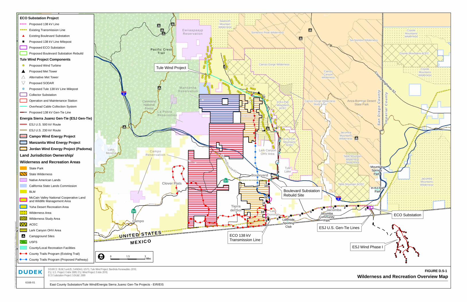
As shown in Figure D.5-1, Wilderness and Recreation Overview Map, federal and state wilderness and recreational areas in the general vicinity of the Proposed PROJECT include Cuyamaca Rancho State Park, Cleveland National Forest, McCain Valley National Cooperative Land and Wildlife Management Area, and the Anza-Borrego Desert State Park. Numerous federal wilderness areas and areas of environmental concern, along with several state wilderness management areas, are also located in the general vicinity of the Proposed PROJECT. Also located in the area are County and local facilities including Jacumba Community Park, Tule Lake, Lake Domingo, and the Lakeside Sportsmans Club. In general, the recreation and wilderness areas in the vicinity of the Proposed PROJECT support a variety of activities including camping, hunting, fishing, and hiking while at the same time placing an emphasis on habitat preservation and conservation efforts.
The following section provides a general description (including permitted activities) of the wilderness and recreation areas in the vicinity of the Proposed PROJECT. The discussion is organized by federal and state wilderness and recreation areas and county and local recreational facilities.
Federal and State Wilderness and Recreation Areas
BLM Special Designation Areas
McCain Valley National Cooperative Land and Wildlife Management Area. Located within the Peninsular Ranges, in southeastern San Diego County (generally north of Interstate 8 (I-8)), the McCain Valley National Cooperative Land and Wildlife Management Area (encompassing 38,960 acres) is administered by the BLM for a variety of uses including wildlife conservation, livestock grazing, and recreation (BLM 2008). Permitted recreational activities within the conservation area include camping, hunting, hiking, backpacking, mountain biking, and off-highway vehicle (OHV) use (BLM 2009c). Nature and scenic photography from the Sacatone and Carrizo Overlooks are also popular recreational activities within the area. The In-Ko-Pah Mountains Area of Critical Environmental Concern (ACEC), Carrizo Gorge Wilderness Area, Cottonwood Campground, and the Lark Canyon OHV Area (discussed in greater detail as follows) are all located within the boundaries of the McCain Valley National Cooperative Land and Wildlife Management Area.
CampoReservat ion
Manzani taReservat ion
045
67
11
89
10
13
12
123
JacumbaMountainsWilderness
Carrizo Gorge Wilderness
Table Mountain ACEC
CoyoteMountainsWilderness
Coyote Mountains ACEC
CoyoteMountainsWilderness
In-Ko-PahMountains
ACEC
In-Ko-PahMountains
ACEC
Table MountainWildernessStudy Area
SawtoothMountain
Wilderness
LakesideSporting
Club
JacumbaCommunity
Park
In-Ko-PahPark
MountainSprings
Park
Sombrero Peak Wilderness
CarrizoCanyon
Wilderness
JacumbaMountainsWilderness
Sin Nombre Wilderness
8
7
6
5
3
2
1
4
0
9
Wilderness and Recreation Overview MapSOURCE: BLM; SanGIS; SANDAG; USFS; Tule Wind Project: Iberdrola Renewables 2010;ESJ U.S. Project: Entrix 2009; ESJ Wind Project: Entrix 2010;ECO Substation Project: SDG&E 2009
Z:\P
rojec
ts\j61
6801
\MAP
DOC\
MAP
S\EI
REIS
Fig
s\Sec
tion
D\Fi
g D5
-1 W
ilder
ness
Ove
rvie
w.m
xd
6168-01
Old Hig
hway 80
San
Die
go
Co
un
ty
Imp
eria
l C
ou
nty
UNIT ED STAT ES
MEX IC O
Carrizo Gorge WildernessStudy Area
ESJ U.S. Gen-Tie Lines
ESJ Wind Phase I
ECO Substation
Boulevard SubstationRebuild Site
Tule Wind Project
Anza-Borrego DesertState Park
ClevelandNationalForest
ECO Substation ProjectProposed 138 kV Line
Existing Transmission Line
Existing Boulevard Substation
Proposed 138 kV Line Milepost
Proposed ECO Substation
Proposed Boulevard Substation Rebuild
Tule Wind Project ComponentsProposed Wind Turbine
Proposed Met Tower
Alternative Met Tower
Proposed SODAR
Proposed Tule 138 kV Line Milepost
Collector Substation
Operation and Maintenance Station
Overhead Cable Collection System
Proposed 138 kV Gen-Tie Line
Energia Sierra Juarez Gen-Tie (ESJ Gen-Tie)ESJ U.S. 500 kV Route
ESJ U.S. 230 kV Route
Campo Wind Energy Project
Manzanita Wind Energy Project
Jordan Wind Energy Project (Padoma)
Land Jurisdiction Ownership/
Wilderness and Recreation AreasState Park
State Wilderness
Native American Lands
California State Lands Commission
BLM
McCain Valley National Cooperative Landand Wildlife Management Area
Yuha Desert Recreation Area
Wilderness Area
Wilderness Study Area
ACEC
Lark Canyon OHV Area
Campground Sites
USFS
County/Local Recreation Facilities
County Trails Program (Existing Trail)
County Trails Program (Proposed Pathway)
Ewi iaa paaypReservat ion
0 31.5Miles
Boulevard
JacumbaTierradel Sol
Clover Flats
Campo
LakeMorena
La PostaReservat ion
Lark CanyonOHV Area
East County Substation/Tule Wind/Energia Sierra Juarez Gen-Tie Projects - EIR/EIS
County Highway S2
FIGURE D.5-1
Pa ci f ic CrestTra i l
TuleLake
LakeDomingo
ECO 138 kVTransmission Line
East County Substation/Tule Wind/Energia Sierra Juarez Gen-Tie Projects D.5 WILDERNESS AND RECREATION
December 2010 D.5-4 Draft EIR/EIS
INTENTIONALLY LEFT BLANK
East County Substation/Tule Wind/Energia Sierra Juarez Gen-Tie Projects D.5 WILDERNESS AND RECREATION
December 2010 D.5-5 Draft EIR/EIS
In-Ko-Pah Mountains ACEC. The 9,743-acre In-Ko-Pah Mountains ACEC, which includes a significant portion of the Carrizo Gorge Wilderness in its boundaries and abuts the Anza-Borrego Desert State Park to the north and the east, is located north of I-8 within the McCain Valley National Cooperative Land and Wildlife Management Area (BLM 2008). Approximately 12,600 acres of BLM-administered land including all of the In-Ko-Pah Mountains ACEC was recommended for withdrawal from all forms of land entry in the BLM’s October 2008 Eastern San Diego County Resource Management Plan; however, nonmotorized public access is still allowed within the ACEC, and permitted activities include hunting, fishing, and camping (Simmons, pers. comm. 2009).
Carrizo Gorge Wilderness. Located approximately 60 miles east of downtown San Diego, the 14,735-acre Carrizo Gorge Wilderness offers numerous scenic views of the surrounding areas, including the Anza-Borrego Desert State Park, Salton Sea, and the Chocolate Mountains (BLM 2008). According to the BLM, the Carrizo Gorge Wilderness is the only ecological transition zone between the Colorado Desert and the peninsular mountain ranges (BLM 2009b). While motorized vehicles are not permitted within this wilderness area, hunting, camping, and fishing are permitted by state and local law (BLM 2009b). The 1,012-acre Carrizo Gorge Wilderness Study Area is designated on lands between the Carrizo Gorge Wilderness and the In-Ko-Pah Mountains ACEC.
Lark Canyon Off-Highway Vehicle (OHV) Area. Located within the McCain Valley National Cooperative Land and Wildlife Management Area, the Lark Canyon OHV Area features several miles of trails and a campground accessible off McCain Valley Road. Riding season is open year-round to “green-stickered” vehicles (those certified to California OHV emission standards); “red-stickered” vehicles (those not certified to California OHV emission standards) are permitted from October 1 to April 30, and the area is limited to vehicles 40 inches or less in width (BLM 2009d). The Lark Canyon Campground features fire rings, access to water, and restrooms (BLM 2009d).
Cottonwood Campground. Located in the northern extent of the McCain Valley National Cooperative Land and Wildlife Management Area, the Cottonwood Campground contains 30 developed campsites, fire rings, tables, and numerous hiking trails connecting it to surrounding wilderness areas (BLM 1997).
Jacumba Mountains Wilderness. Administered by the BLM, the 31,357-acre Jacumba Mountains Wilderness is located approximately 30 miles west of El Centro in Imperial County. Motorized vehicles are not permitted in the Jacumba Mountains Wilderness; however, hunting, fishing, camping, and horseback riding are permitted by state and local law (BLM 2009a).
East County Substation/Tule Wind/Energia Sierra Juarez Gen-Tie Projects D.5 WILDERNESS AND RECREATION
December 2010 D.5-6 Draft EIR/EIS
Sawtooth Mountains Wilderness. The 33,598-acre Sawtooth Mountains Wilderness is located approximately 35 miles south of Borrego Springs (BLM 2008). Due to private property around the border, there is no legal access to this wilderness area (the Pepperwood Trail at the end of northern terminus of McCain Valley Road provides the only access to the area) (BLM 2009e). Permitted activities within this wilderness area include hunting, fishing, and backcountry camping (motorized vehicles are not permitted). The Sawtooth Mountains Wilderness is located north of the McCain Valley National Cooperative Land and Wildlife Management Area.
Table Mountain ACEC. Surrounded by the Anza-Borrego Desert State Park and located north of I-8, the 5,213-acre Table Mountain ACEC permits motorized vehicles on specific trails and additional recreational activities including camping, hiking, and rockhounding (BLM 2008). The Table Mountain ACEC is administered by the BLM.
Table Mountain Wilderness Study Area. The 1,018-acre Table Mountain Wilderness Study Area is located north of the Table Mountain ACEC (BLM 2008). Motor vehicles, motorized equipment, and other forms of mechanical transport are not allowed within wilderness study areas (BLM 2008). Permitted activities include backcountry camping and horseback riding.
BLM Special Recreation Management Areas and Recreation Management Zones
As shown on Figure D.5-2, BLM Special Recreation Management Areas and Recreation Management Zones, the BLM separates the Eastern San Diego County Planning Area (in which the Proposed PROJECT is located) into three Destination Special Recreation Management Areas: the Julian Destination Special Recreation Management Area, Sawtooth Destination Special Recreation Management Area, and Boulevard/Jacumba Destination Special Recreation Management Area. Destination Special Recreation Management Areas are separated geographically, with the Julian Destination Special Recreation Management Area located in the northern Eastern San Diego County Planning Area and the Boulevard/Jacumba Destination Special Recreation Management Area located in the southern planning area (the Sawtooth Destination Special Recreation Management Area occurs between the Julian and Boulevard/Jacumba Destination Special Recreation Management Areas). The Proposed PROJECT is located entirely within the Boulevard/Jacumba Destination Special Recreation Management Area, which is managed specifically to target destination recreation-tourism (BLM 2008).
As shown on Figure D.5-2, BLM Special Recreation Management Areas and Recreation Management Zones, Destination Special Recreation Management Areas are separated into distinct recreational niches or Recreation Management Zones. Recreation Management Zones often include the wilderness area or wilderness study area of the same name (for example, the Carrizo Gorge Recreation Management Zone includes the same land as the Carrizo Gorge Wilderness).
!!
!!
!!
!
!
!!
!!!!
!
!!
!!
!
!!!
!
!!!!!!!!!!!!!
!!
!
!
!
!!
!!!
!
!
!
!!
!!!
!
!
!!
!!
!
! !
!
!!!!!!
!!! !
!!!!!!
!!!
!!!
!!!
!!
!!!!!
!!
!
!
!
!
!
!!
! !!!
!!!!
!
!
!!
!!!
!
!
!
Tule WindProject Site
ESJ Gen-TieProject Site
ESJ Gen-Tie Project Site
ECO Substation Project Site
Tule Wind Project Components! Proposed Turbine
ECO SubstationProject Site
Cumulative Projects:Transmission/Renewable Energy
Campo Wind Energy Project
Manzanita Wind Energy Project
Jordan Wind Energy Project (Padoma)
Jordan Wind Energy Project (Padoma)
Campo WindEnergy Project
Manzanita WindEnergy Project
East County Substation/Tule Wind/Energia Sierra Juarez Gen-Tie Projects EIR/EIS6168-01
Z:\P
rojec
ts\j61
6801
\MAP
DOC\
MAPS
\EIR
EIS
Figs
SOURCE: BLM 2008
BLM Special Recreation Management Areas and Recreation Management ZonesFIGURE D.5-2
East County Substation/Tule Wind/Energia Sierra Juarez Gen-Tie Projects D.5 WILDERNESS AND RECREATION
December 2010 D.5-8 Draft EIR/EIS
INTENTIONALLY LEFT BLANK
East County Substation/Tule Wind/Energia Sierra Juarez Gen-Tie Projects D.5 WILDERNESS AND RECREATION
December 2010 D.5-9 Draft EIR/EIS
The Boulevard/Jacumba Destination Special Recreation Management Area includes five designated Recreation Management Zones, which are discussed briefly in the following paragraphs (the Sawtooth Mountains Wilderness Semi-Primitive Recreation Management Zone is included due to its proximity to the Tule Wind Project). A detailed discussion of Destination Special Recreation Management Areas and Recreation Management Zones is included in Section D.5.2.1.
Airport Mesa Recreation Management Zone. The Airport Mesa Recreation Management Zone is located south of the Table Mountain ACEC and extends south from I-8 to the U.S.–Mexico international border. Primary recreational activities within the Airport Mesa Recreation Management Zone include hiking and hunting (BLM 2008).
Carrizo Gorge Wilderness Recreation Management Zone. The Carrizo Gorge Wilderness Recreation Management Zone covers the same land as the Carrizo Gorge Wilderness. The recreational amenities of the Carrizo Gorge Wilderness are discussed in the previous “State and Federal Wilderness and Recreation Areas” section.
McCain Valley Recreation Management Zone. With the exception of the Carrizo Gorge Wilderness, the McCain Valley Recreation Management Zone covers the same land as the McCain Valley National Cooperative Land and Wildlife Management Area. The recreational amenities of the McCain Valley National Cooperative Land and Wildlife Management Area are discussed in the previous section.
Table Mountain Recreation Management Zone. The Table Mountain Recreation Management Zone is located northeast of Jacumba (north of I-8) and covers the same land as the Table Mountain ACEC. The recreational amenities of the Table Mountain ACEC are discussed in the previous section.
Table Mountain Wilderness Study Area Recreation Management Zone. Located north of the Table Mountain Recreation Management Zone (and Table Mountain ACEC), the Table Mountain Wilderness Study Area Recreation Management Zone covers the same land as the Table Mountain Wilderness Study Area. Primary recreational activities within the Table Mountain Wilderness Study Area Recreation Management Zone include hiking, horseback riding, backcountry travel, and hunting (BLM 2008).
Sawtooth Mountains Wilderness Semi-Primitive Recreation Management Zone. The Sawtooth Mountains Wilderness Semi-Primitive Recreation Management Zone contains nearly all the land designated Sawtooth Mountains Wilderness. The recreational amenities of the Sawtooth Mountain Wilderness are discussed in the previous section.
East County Substation/Tule Wind/Energia Sierra Juarez Gen-Tie Projects D.5 WILDERNESS AND RECREATION
December 2010 D.5-10 Draft EIR/EIS
U.S. Forest Service
Cleveland National Forest. Consisting of approximately 460,000 acres, the Cleveland National Forest is the southernmost national forest in Southern California and offers diverse terrain and recreational opportunities. As shown on Figure D.5-1, Wilderness and Recreation Overview Map, several campgrounds within the Cleveland National Forest are located near the Ewiiaapaayp Band of Kumeyaay Indians tribal lands and the BLM-administered Sawtooth Mountains Wilderness. Also, the Pacific Crest Trail winds along the eastern boundary of the national forest in the project area, generally east of the Sunrise Highway (see Figure D.5-1, Wilderness and Recreational Overview Map).
California State Parks
Anza-Borrego Desert State Park. The largest state park in California, the Anza-Borrego Desert State Park includes more than 500 miles of dirt roads, 12 wilderness management areas, and numerous hiking trails (CDPR 2009). Permitted recreational activities within the park include camping, horseback riding, and wildlife viewing (CDPR 2009).
As stated previously, the Anza-Borrego Desert State Park consists of 12 wilderness management areas or state wilderness. Most wilderness management areas are contiguous with one another, but some are separated by railroad corridors (such as the San Diego and Arizona Eastern railroad corridor, which separates the Carrizo Canyon Wilderness Management Area and the Jacumba Mountains Wilderness Management Area) or roadways (County Highway S2 separates the Carrizo Gorge Wilderness Management Area and the Sin Nombre Wilderness Management Area). As shown on Figure D.5-1, Wilderness and Recreation Overview Map, two wilderness management areas border the BLM-administered McCain Valley National Cooperative Land and Wildlife Management Area: Sombrero Peak and Carrizo Canyon. A third wilderness management area, the Jacumba Mountains Wilderness Management Area, adjoins the northern boundary of the Table Mountain ACEC.
Cuyamaca Rancho State Park. Located approximately 10 miles west of the Tule Wind Project area, Cuyamaca Rancho State Park includes campsites, picnic areas, over 100 miles of hiking trails, opportunities for wildlife viewing and photography, and fishing at Lake Cuyamaca (operated by Helix Water District) (CDPR 2010). Due to the location of Cuyamaca Rancho State Park and the geographical extent of Figure D.5-1, the location of the park is not shown on the figure.
County and Local Recreational Facilities
The location of the following county and local recreational facilities is illustrated on Figure D.5-1, Wilderness and Recreation Overview Map.
East County Substation/Tule Wind/Energia Sierra Juarez Gen-Tie Projects D.5 WILDERNESS AND RECREATION
December 2010 D.5-11 Draft EIR/EIS
Jacumba Community Park. The 20-acre Jacumba Community Park is located near the Jacumba Branch Library, south of Old Highway 80, in Jacumba. Recreational amenities at the park include a playground, baseball field, basketball court, and open playing fields.
Mountain Springs Park. Located north of I-8, west of the Imperial County border, and bordered on the west by the Jacumba Mountains Wilderness Management Area (Anza-Borrego Desert State Park), the 129-acre undeveloped Mountain Springs Park is preserved by the County as open space (County of San Diego 2010a).
In-Ko-Pah Park. Located approximately 1.25 miles south of Mountain Springs Park, the 158-acre In-Ko-Pah Park is preserved by the County as open space (County of San Diego 2010a).
Lake Domingo. Located north of Boundary Peak and approximately 1 mile north of the U.S.–Mexico international border, Lake Domingo offers limited recreational opportunities. The existing Southwest Powerlink (SWPL) transmission line is located south of Lake Domingo.
Tule Lake. Similar to Lake Domingo, Tule Lake offers limited recreational opportunities. Fishing is permitted at this private lake located approximately 1.75 miles northeast of the Boulevard Substation Rebuild site and 2,600 feet east of the intersection of McCain Valley Road and Rocky Knoll Road.
Lakeside Sportsmans Club. Recreational amenities at the Lakeside Sportsmans Club include dry camping grounds, an outdoor shooting range, a clubhouse, restroom facilities, and a children’s play yard (Lakeside Sportsmans Club 2009). Membership is required at this private club located approximately 1.5 miles southeast of Lake Domingo.
County Trails/Pathways
The following trails and pathways are located in the Boulevard Community Plan Area. Trail and pathway status (i.e., existing or proposed) and length of the trail or pathway are also provided in the following list. It should be noted that the Community Trails Master Plan does not include an individual trails and pathways plan for the community of Jacumba.
Ribbonwood Road Pathway (proposed, 2.16 miles) Ribbonwood Trail (existing, 4.40 miles) Jewel Valley Road Pathway (proposed, 3.20 miles) Jewel Valley Trail (existing, 2.21 miles) San Diego and Arizona Eastern Railway Trail (existing, 13.00 miles) Lansing Trail (existing, 3.0 miles) Tierra del Sol Trail (existing, 4.80 miles)
East County Substation/Tule Wind/Energia Sierra Juarez Gen-Tie Projects D.5 WILDERNESS AND RECREATION
December 2010 D.5-12 Draft EIR/EIS
Shockey Truck Trail (existing, 2.90 miles)
Shockey Loop Trail (existing, 2.55 miles).
In addition to the recreational facilities identified above, designated bicycle routes are also located in the project area. Both Old Highway 80 and SR-94 are designated as part of the County’s Bicycle Network System on the General Plan Circulation Element Map (Map 7) (County of San Diego 1998).
D.5.1.2 ECO Substation Project
ECO 500/230/138 kV Substation
The ECO 500/230/138-kilovolt (kV) Substation site is not located on federal- or state-designated wilderness land, and wilderness and recreation lands do not abut the site. As shown on Figures D.5-1, Wilderness and Recreation Overview Map, and D.5-3, ECO Substation Project Wilderness and Recreation Map, the nearest wilderness and recreational areas are the Table Mountain ACEC (located approximately 2,400 feet northwest of the substation yards, north of I-8), and the Jacumba Mountains Wilderness (approximately 1.2 miles east of the substation yards in Imperial County). Also, the southernmost boundary of the Anza-Borrego Desert State Park is located approximately 1.5 miles north of the substation site and north of I-8. Figure D.5-3, ECO Substation Project Wilderness and Recreation Map, depicts the location of the ECO Substation and the nearest wilderness and recreation areas.
Southwest Powerlink Loop-In
Similar to the ECO Substation site, the SWPL site is not located on federal- or state-designated wilderness land. The SWPL site would be located slightly east of the ECO Substation, and therefore, the wilderness areas nearest to the ECO substation are also applicable to the SWPL Loop-In site.
138 kV Transmission Line
As shown on Figure D.5-2, BLM Special Recreation Management Areas and Recreation Management Zones, the proposed 138 kV transmission line would traverse the BLM-administered Airport Mesa Recreation Management Zone. Managed for its rural recreation qualities, the Airport Mesa Recreation Management Zone is an exclusion area for renewable energy development (with the exception of geothermal mineral leasing) (BLM 2008). It should be noted, however, that the BLM has designated a substantial portion of the Airport Mesa Recreation Management Zone as a utility corridor through which the existing SWPL passes and the proposed Sunrise Powerlink transmission line would pass if constructed. The proposed 138 kV transmission line would also be located within the designated utility corridor. No other federal or state wilderness and recreation area would be traversed by the proposed transmission line.
Campo Reservat ion
10
11
12
13
01234
5
67
89
JacumbaMountainsWilderness
CarrizoGorge
Wilderness
Table Mountain ACEC
Table MountainWildernessStudy Area
In-Ko-PahMountains
ACEC
LakesideSporting
Club
JacumbaCommunity
Park
In-Ko-PahPark
MountainSprings
Park
TuleLake
LakeDomingo
CarrizoCanyon
Wilderness
JacumbaMountainsWilderness
8
7
6
5
9
ECO Substation Project Wilderness and Recreation Map
Tule Wind Project:Proposed TurbineProposed Tule 138 kV Line MilepostProposed 138 kV Gen-Tie Line
Energia Sierra Juarez Gen-Tie (ESJ) Gen-Tie ProjectESJ Gen-Tie 500 k V RouteESJ Gen-Tie 230 k V RouteESJ Wind Phase I Underground Cable Collection SystemESJ Wind Phase I Gen-Tie LineESJ Wind Phase I Turbine LocationsESJ Wind Phase I Jacume Substation
Campo Wind Energy ProjectJordan Wind Energy Project (Padoma)
Land Jurisdiction Ownership/Wilderness and Recreation Areas
State ParkState WildernessNative American Lands
BLMMcCain Valley National Cooperative Landand Wildlife Management AreaYuha Desert Recreation AreaWilderness AreaWilderness Study AreaACECLark Canyon OHV AreaCampground SitesCounty/Local Recreation FacilitiesCounty Trails Program (Existing Trail)County Trails Program (Proposed Pathway)
U N I T E D S T A T E S
M E X I C O
San Diego and ArizonaEastern Railroad
San
Die
go
Co
un
ty
Imp
eria
l C
ou
nty
East County Substation/Tule Wind/Energia Sierra Juarez Gen-Tie Projects - EIR/EIS
East County Substation/Tule Wind/Energia Sierra Juarez Gen-Tie Projects D.5 WILDERNESS AND RECREATION
December 2010 D.5-14 Draft EIR/EIS
INTENTIONALLY LEFT BLANK
East County Substation/Tule Wind/Energia Sierra Juarez Gen-Tie Projects D.5 WILDERNESS AND RECREATION
December 2010 D.5-15 Draft EIR/EIS
While the proposed transmission line would not traverse any other federal or state wilderness and recreation areas, the alignment would be located in close proximity to an ACEC and a state park. As shown in Figure D.5-3, ECO Substation Project Wilderness and Recreation Map, upon exiting the ECO Substation, the transmission line would be located approximately 2,400 feet south of the Table Mountain ACEC and 1.5 miles south of Anza-Borrego Desert State Park. At several other locations along the alignment route (e.g., near Mileposts (MPs) 3 and 4), the proposed transmission line would be closer than 1 mile to the Anza-Borrego Desert State Park. Between MPs 3.6 and 4.9, the transmission line would cross land currently owned and managed by the Nature Conservancy. The Anza-Borrego Foundation is attempting to purchase the land; however, as of December 18, 2009, the land had not yet been acquired by the Foundation (Tandle, pers. comm. 2009).
In addition to federal and state recreation facilities, the proposed transmission line alignment would be located in the vicinity of County facilities. As shown in Figure D.5-3, ECO Substation Project Wilderness and Recreation Map, near MP 4.0, the proposed 138 kV transmission line would be located approximately 3,700 feet north of the Jacumba Community Park and near MP 7.4; the transmission line would be located approximately 2,400 feet north of the Lakeside Sportsmans Club. Also, near MP 9.0, the transmission line would be located approximately 300 feet south of Lake Domingo. Several trail and pathway corridors (including the San Diego and Arizona Eastern Railway Trail, Jewel Valley Trail, Lansing Trail, and the Jewel Valley Road Pathway corridors) identified in the Boulevard Community Trails and Pathways Plan would also be crossed by the proposed alignment.
Boulevard Substation Rebuild
As shown in Figure D.5-3, ECO Substation Project Wilderness and Recreation Map, the Boulevard Substation Rebuild site is located approximately 1.5 miles southwest of Tule Lake, 1.75 miles southwest of the McCain Valley National Cooperative Land and Wildlife Management Area, 2.25 miles southwest of the Carrizo Gorge Wilderness, and 2.5 miles southwest of the In-Ko-Pah Mountains ACEC. These recreational areas are all located north of I-8.
D.5.1.3 Tule Wind Project
As shown on Figure D.5-4, Tule Wind Project Wilderness and Recreation Areas, the Tule Wind Project would be located primarily on BLM land within the McCain Valley National Cooperative Land and Wildlife Management Area. A variety of recreation uses, including OHV use, camping, and hiking, are permitted within this area. The In-Ko-Pah Mountains ACEC, Carrizo Gorge Wilderness, Lark Canyon OHV Area and Campground, and the Cottonwood Campground (all administered by the BLM) are located within the boundaries of the McCain
East County Substation/Tule Wind/Energia Sierra Juarez Gen-Tie Projects D.5 WILDERNESS AND RECREATION
December 2010 D.5-16 Draft EIR/EIS
Valley National Cooperative Land and Wildlife Management Area (see Figure D.5-4, Tule Wind Project Wilderness and Recreation Areas).
As shown in Figure D.5-2, BLM Special Recreation Management Areas and Recreation Management Zones, all Tule Wind project components would be located within the BLM-designated McCain Valley Recreation Management Zone. According to the BLM, this area is “managed for its historical, cultural, and natural qualities while continuing to be managed as a diverse recreational area supporting a developed recreational trail system for OHV day-use area, developed recreation facilities (e.g., campgrounds and other sites), and natural resource qualities” (BLM 2008).
Wind Turbines and Overhead and Underground Collector Cable System
As shown on Figure D.5-4, Tule Wind Project Wilderness and Recreation Areas, nearly all turbines would be located on BLM-administered land within the McCain Valley National Cooperative Land and Wildlife Management Area (turbines would also be located on Ewiiaapaayp Band of Kumeyaay Indians tribal lands, lands owned by the California State Lands Commission, and private land under the jurisdiction of the County). Wind turbines and the overhead and underground collector cable system would not be located within designated wilderness, wilderness study areas, or ACECs (renewable energy facilities and land use authorizations for commercial purposes are not permitted in wilderness areas, wilderness study areas, or ACECs (BLM 2008)). Several turbine strings would, however, be located near special designation areas, state park lands, and campgrounds. For example, several turbines in the proposed J-string would be located on the Ewiiaapaayp Indian tribal lands that are bound to the north and east by the Sawtooth Mountains Wilderness (the closest turbine would be located within 200 feet of the wilderness boundary). Several other turbine strings (D- and E-strings on BLM land and R-strings on County lands) would be located on lands bordering the In-Ko-Pah Mountains ACEC and the Carrizo Gorge Wilderness Study Area. The closest turbine in the D-string would be located approximately 1.25 miles west of the In-Ko-Pah ACEC border, while the closest turbines in the E- and R-strings would be located within 100 feet of the ACEC border. The closest turbine in the R-string would be located approximately 4,000 feet west of the Carrizo Gorge Wilderness Study Area border. Turbines in the D- and E-strings would also be located within 1,300 feet of the Carrizo Overlook, a scenic viewpoint located approximately 1,000 feet northeast of McCain Valley Road. Lastly, several turbines in the G-turbine string would be located approximately 1,300 feet west of the Lark Canyon Campground, and the closest turbine in the A-string would be located approximately 1,300 feet northeast of the Cottonwood Campground.
Manzan ita Reservat ion
Campo Reservat ion
In-Ko-Pah Mountains ACEC
In-Ko-Pah Mountains ACEC
Carrizo Gorge Wilderness
SawtoothMountain
Wilderness
CottonwoodCampground
Lark CanyonCampground
Bow WillowCampground
TuleLake
E5
G16
G17
K11K12
B6
B7
D7
E2
F1
F2
G5
E6 E7 E8
E11
G1G2
B2B3
E12
D1D2
PM-W1
D3
PM-E1
PM-E2
PM-W2
B4
G3G4
G6
G7
G8
G9G10
G11
G12
G13G14
G15
C1C2
D10
C3
C4
F3
F4
E4
E9 E10
D9
G18
R11
D4D5
A1
A2
A3
B5
A4
D6
D8
A5A6
B1
E1E3
R12
R1
R2R3
R4
R5R6
R8R9
R7R10
L7
L6
L5
L3L2L1
L9L10
L11N4
N5N6
N3N2
N1
M2
M1
P1P2P3
P4P5
L4
K8
K5
J3
J4
Q1
L8
N7
K7 J15
J14J13
J10J9J8
J6
J5
K1
J2J1
K4
J11K3
K2
Q2
K9A8
N8
B8
B9
C6
C5
F6
F5
G19
R13
A7
Sombrero Peak Wilderness
CarrizoCanyon
Wilderness
0
1
2
3
4
5
6
7
8
9
Tule Wind Project Wilderness and Recreation Areas6168-01
0 10.5Miles
Z:\P
rojec
ts\j61
6801
\MAP
DOC\
MAP
S\EI
REIS
Fig
s\Sec
tion
D\Fi
g D5
-4 T
ule
Wild
erne
ss.m
xd
Tule Wind Project ComponentsProposed Wind Turbine
Proposed Met Tower
Alternative Met Tower
Proposed SODAR
Proposed Tule 138 kV Line Milepost
Overhead Cable Collection System
Underground Cable Collection System
Proposed 138 kV Gen-Tie Line
Existing Roads to be Improved
Proposed New Roads
Operation and Maintenance Facility
Collector Substation
2-acre Laydown Areas
5-acre Concrete Batch Plant
10-acre Parking Area
Rough Arcres Ranch
ECO Substation ProjectProposed 138 kV Line
Existing Transmission Line
Proposed ECO Substation
Proposed Boulevard Substation Rebuild
Transmission/Renewable EnergyCampo Wind Energy Project
Manzanita Wind Energy Project
Jordan Wind Energy Project (Padoma)
Land Jurisdiction Ownership/Wilderness and Recreation Areas
State Park
State Wilderness
Native American Lands
BLM
McCain Valley National Cooperative Landand Wildlife Management Area
Wilderness Area
Wilderness Study Area
ACEC
Lark Canyon OHV Area
USFS
Campground Sites
California State Lands Commission
County Trails Program (Existing Trail)
County Trails Program (Proposed Pathway)
Old Highway 80
Rib
bonw
ood
Roa
d
Old Highway 80
BOULEVARD
McC
ain
Val
ley
Roa
d
Boulevard SubstationRebuild Site
East County Substation/Tule Wind/Energia Sierra Juarez Gen-Tie Projects - EIR/EIS
East County Substation/Tule Wind/Energia Sierra Juarez Gen-Tie Projects D.5 WILDERNESS AND RECREATION
December 2010 D.5-18 Draft EIR/EIS
INTENTIONALLY LEFT BLANK
East County Substation/Tule Wind/Energia Sierra Juarez Gen-Tie Projects D.5 WILDERNESS AND RECREATION
December 2010 D.5-19 Draft EIR/EIS
Collector Substation and Operations and Maintenance Facility
As shown on Figures D.5-1, Wilderness and Recreation Overview Map, and D.5-4, Tule Wind Project Wilderness and Recreation Areas, the 5-acre collector substation site and the 5-acre operations and maintenance (O&M) facility would be located in the McCain Valley National Cooperative Land and Wildlife Management Area, not within a designated wilderness area, wilderness study area, or ACEC. The nearest Special Designation Area, the In-Ko-Pah Mountains ACEC, would be located approximately 1.5 miles east of the proposed collector substation and O&M facility sites.
Meteorological Towers
As shown on Figure D.5-4, Tule Wind Project Wilderness and Recreation Areas, meteorological towers and a sonic detecting and ranging (SODAR) unit would be installed within the McCain Valley National Cooperative Land and Wildlife Management Area. Although four meteorological towers are shown on Figure D.5-4, only two (PM-E1 and PM-W2) are proposed locations at this time (PM-E2 and PM-W1 are alternative locations). PM-E1 would be installed approximately 1,300 feet west of the Carrizo Overlook, and PM-W-2 would be installed within the Lark Canyon OHV Area, approximately 2,600 feet west of the Lark Canyon Campground. As proposed, the SODAR unit would be installed immediately west of PM-W2.
138 kV Overhead Transmission Line
As shown on Figure D.5-4, Tule Wind Project Wilderness and Recreation Areas, the proposed 138 kV overhead transmission line would primarily traverse land within the McCain Valley National Cooperative Land and Wildlife Management Area. Southeast of the proposed collector substation and near the R-turbine string, the 138 kV transmission line would be located within 800 feet of the western boundary of the In-Ko-Pah Mountains ACEC. This approximate 1.5-mile segment of the transmission line would also be located within 2,600 feet of the Lark Canyon OHV Area and the Lark Canyon Campground. After crossing McCain Valley Road (south of southernmost turbine in the R-string) the transmission line would turn south and traverse BLM-administered land located within 800 feet of the western boundary of the In-Ko-Pah Mountains ACEC. The remaining segment of the transmission line would not be located within a Special Designation Area. Approximately 2,600 feet north of I-8 along McCain Valley Road, the proposed transmission line would be located within 4,000 feet of Tule Lake (the southern extent of the Carrizo Gorge Wilderness is located approximately 2,600 feet east of Tule Lake).
D.5.1.4 ESJ Gen-Tie Project
The ESJ Gen-Tie Project would not be located on or traverse federal, state, or local wilderness and recreational areas. As shown on Figure D.5-1, Wilderness and Recreation Overview Map,
East County Substation/Tule Wind/Energia Sierra Juarez Gen-Tie Projects D.5 WILDERNESS AND RECREATION
December 2010 D.5-20 Draft EIR/EIS
and Figure D.5-3, ECO Substation Project Wilderness and Recreation Areas, the nearest federal wilderness and recreation areas are the BLM-administered Table Mountain ACEC (located approximately 4,000 feet to the northwest) and the Jacumba Mountains Wilderness (located 1.5 miles to the east). The nearest state recreation area is the Anza-Borrego Desert State Park (Jacumba Mountains Wilderness), which is located approximately 1.5 miles north of the ESJ Gen-Tie Project site. In-Ko-Pah Park, the nearest County recreation area to the project site, is located approximately 2 miles to the north of the site.
D.5.2 Applicable Regulations, Plans, and Standards
The following section presents a general description of plans, policies, ordinances, and regulations applicable to the Proposed PROJECT, as well as the Campo, Manzanita, and Jordan wind energy projects. In addition to the federal regulations identified, the Campo and Manzanita wind energy projects may be subject to the Bureau of Indian Affairs’ (BIA’s) policies and regulations and tribe-specific policies and plans.
D.5.2.1 Federal Regulations
Wilderness Act of 1964
The Wilderness Act of 1964 (16 U.S.C. 1131 et seq.) established a National Wilderness Preservation System that sought to ensure that future development and an increasing population did not hamper the preservation and protection of lands in their natural state. The Wilderness Act also provides the definition of a federal wilderness area. According to the Act, wilderness is defined as:
A wilderness area, in contrast to those areas where a man and his own works dominate the landscape, is hereby recognized as an area where the earth and its community of life are untrammeled by man, where man himself is a visitor who does not remain. A wilderness area is further defined to mean in this Act an area of undeveloped Federal land retaining its primeval character and influence without permanent improvements or human habitation which is protected and managed so as to preserve its natural conditions and which (1) generally appears to have been affected primarily by the forces of nature with the imprint of man’s work substantially unnoticeable; (2) has outstanding opportunities for solitude or a primitive and unconfined type of recreation; (3) has at least five thousand acres of lands or is of sufficient size as to make practicable its preservation and use in an unimpaired condition; and (4) may also contain ecological, geological, or other features of scientific, educational, scenic, or historical value.
East County Substation/Tule Wind/Energia Sierra Juarez Gen-Tie Projects D.5 WILDERNESS AND RECREATION
December 2010 D.5-21 Draft EIR/EIS
In addition, the Wilderness Act also prohibits certain uses (including commercial enterprises, permanent or temporary roads, motor vehicles, motorized equipment, motorboats, landing of aircraft, any form of mechanical transport, and structures or installations) from occurring on federally designated wilderness areas (16 U.S.C. 1131 et seq.).
Endangered American Wilderness Act
Furthering the purpose of the Wilderness Act of 1964, the Endangered American Wilderness Act of 1978 (Public Law 95-237) designated 17 additional lands within the United States as wilderness areas.
Federal Land Policy and Management Act
The Federal Land Policy and Management Act (FLPMA) of 1976 (43 U.S.C. 1701 et seq.) authorized the designation of applicable BLM-administered lands as ACECs. Section 103 of the FLPMA defines ACEC as “areas within the public lands where special management attention is required (when such areas are developed or used or where no development is required) to protect and prevent irreparable damage to important historic, cultural, or scenic values, fish and wildlife resources or other natural systems or processes, or to protect life and safety from natural hazards” (BLM 2001). While FLPMA does not contain specific procedures or policies related to the management of ACECs, it does require that specific procedures or policies be developed promptly. In addition, FLPMA states that in the development and revision of land use plans, the Secretary of the Interior shall use and observe the principles of multiple use, give priority to the designation and protection of ACECs, and weigh long-term benefits to the public against short-term benefits (BLM 2001).
National Trails System Act
The National Trails System Act was established by Congress in 1968 “in order to provide for the ever-increasing outdoor recreation needs of an expanding population and in order to promote the preservation of, public access to, travel within, and enjoyment and appreciation of the open-air, outdoor areas and historic resources of the Nation” (16 U.S.C. 1241 et seq.). The act defined four categories of national trails: National Trails System, National Scenic Trails, National Historic Trails, and National Recreation Trails. The Appalachian Trail and the Pacific Crest Trail were designated as the initial components of the National Trails System.
43 CFR 6300 and 8560 (Wilderness Management Final Rule)
In its Wilderness Management Final Rule, the BLM updated existing regulations directing the management of designated wilderness areas. Further, the final rule clarified what uses the BLM allows/authorizes in wilderness areas (and which acts are prohibited), and it addresses access to nonfederal lands occurring within the BLM wilderness areas. An important clarification was made
East County Substation/Tule Wind/Energia Sierra Juarez Gen-Tie Projects D.5 WILDERNESS AND RECREATION
December 2010 D.5-22 Draft EIR/EIS
regarding the definition of mechanized transport and a detailed explanation was given as to why the BLM prohibits such transport within wilderness areas. To summarize, the use of mechanical transport within wilderness areas violates the intent of the wilderness area designation as an area of relatively undeveloped land still in its natural state (65 FR 78358–78376).
California Desert Protection Act
The California Desert Protection Act of 1994 designated the Jacumba Mountains Wilderness and Carrizo Gorge Wilderness as federal wilderness areas. The act also stated that the value of these lands was especially vulnerable to alteration and destruction by activities and intrusions associated with incompatible uses and development, and thereby the application of protective designation and management was necessary (16 U.S.C. 410aaa et seq.).
BLM Eastern San Diego County Resource Management Plan
The intent of the Eastern San Diego County Resource Management Plan (RMP) is to direct future development and manage land within the Eastern San Diego Planning Area in a way that does not impact natural resources. The RMP also addresses conflicts among various recreational users accessing BLM lands, provides direction for future site-specific development including renewable energy projects, and provides for plan monitoring to determine the effectiveness of BLM land management strategies (BLM 2008). The RMP stresses that future policy decisions and land management strategies shall be compatible with the multiple use mission of the BLM (the multiple use mission includes recreational use and responsible development within BLM-administered lands while maintaining environmental quality of the land).
The RMP contains goals, policies, and management actions directed toward Special Designation Areas. The applicable goals, policies, and management actions for Special Designation Areas are discussed in detail in Section D.4, Land Use. As discussed in the RMP, the BLM separates the Eastern San Diego County area into three Destination Special Recreation Management Areas: the Julian Destination Special Recreation Management Area, the Boulevard/Jacumba Destination Special Recreation Management Area, and the Sawtooth Destination Special Recreation Management Area. Because the Julian Destination Special Recreation Management Area is located more than 10 miles north of the Tule Wind project extent, the Julian Destination Special Recreation Management Area is not discussed further in this section. The applicable policies, objectives, and primary market strategies for the Sawtooth Destination Special Recreation Management Area and the Boulevard/Jacumba Special Recreation Management Area (in which the Proposed PROJECT would be located) are listed as follows:
Resource Management Area (RMA)-02 Boulevard/Jacumba Destination Special Recreation Management Area: The Boulevard/Jacumba Destination Special Recreation Management Area includes the most extensively used areas in the planning area and the
East County Substation/Tule Wind/Energia Sierra Juarez Gen-Tie Projects D.5 WILDERNESS AND RECREATION
December 2010 D.5-23 Draft EIR/EIS
established campgrounds, horse corrals, and designated OHV use area and route network. The Special Recreation Management Area also includes lands that are designated as wilderness areas, wilderness study areas, and ACECs. The primary activities in these areas are camping, OHV use, equestrian use, target shooting, hunting, mountain biking, hiking and backpacking, wildflower and wildlife viewing, rockhounding, and pleasure touring. This Special Recreation Management Area will be managed as a regional or national destination through collaborative partnerships to promote the continued use of the lands for these activities.
Primary Market Strategy: The primary market strategy for the proposed Boulevard/Jacumba Destination Special Recreation Management Area will be to target demonstrated destination recreation-tourism market demand for specific activity, experience, and benefit opportunities.
RMA-04 Sawtooth Mountains Special Recreation Management Area: The Sawtooth Destination Special Recreation Management Area is composed primarily of designated wilderness areas and wilderness study areas. The primary activities in these areas are wilderness activities, including hiking and backpacking, hunting, wildflower and wildlife viewing, rockhounding, and equestrian use. Limited OHV use, camping, and day use will be accommodated outside of designated wilderness areas and wilderness study areas. This Special Recreation Management Area will be managed as a regional or national destination through collaborative partnerships to promote the continued use of the lands for these activities.
Primary Market Strategy: The primary market strategy for the proposed Sawtooth Destination Special Recreation Management Area will be to target demonstrated destination recreation-tourism market demand for specific activity, experience, and benefit opportunities.
Each Special Recreation Management Area is further separated into Recreation Management Zones. Each Recreation Management Zone “represents public lands with a distinctive recreation niche (activities, experiences, and benefits) within each Special Recreation Management Area” (BLM 2008). The Boulevard/Jacumba Destination Special Recreation Management Area is separated into five Recreation Management Zones: Airport Mesa, Carrizo Gorge Wilderness, McCain Valley, Table Mountain, and Table Mountain Wilderness Study Area. The Sawtooth Mountain Special Recreation Management Area is separated into two Recreation Management Zones: the Oriflamme Semi-Primitive Recreation Management Zone and the Sawtooth Wilderness Semi-Primitive Recreation Management Zone. The Oriflamme Semi-Primitive Recreation Management Zone is located nearly 10 miles north of the Tule Wind Project extent and is therefore not further discussed. The location of project components and Recreation Management Zones in the project area are depicted on Figure D.5-2. The goals, objectives, and
East County Substation/Tule Wind/Energia Sierra Juarez Gen-Tie Projects D.5 WILDERNESS AND RECREATION
December 2010 D.5-24 Draft EIR/EIS
management actions for the Recreation Management Zones within 5 miles of Proposed PROJECT components are listed as follows:
Recreation Management Zone-02 Airport Mesa: Airport Mesa Recreation Management Zone will be managed for its rural recreational qualities. Primary recreational activities within the Airport Mesa Recreation Management Zone include target hiking and hunting.
Recreation Management Zone-03, Carrizo Gorge Wilderness: The Carrizo Gorge Wilderness Recreation Management Zone consists of the Carrizo Gorge Wilderness Study Area. This Recreation Management Zone will be managed for its wilderness qualities while supporting the needs of the California State Parks in the vicinity. Primary recreational activities within the Carrizo Gorge Wilderness are hiking, horseback riding, hunting, and wildlife viewing.
Recreation Management Zone-04, McCain Valley Recreation Management Zone: The McCain Valley Recreation Management Zone includes the Lark Canyon and Cottonwood campgrounds and developed recreational facilities. This Recreation Management Zone will be managed for its historical, cultural, and natural qualities while continuing to be managed as a diverse recreational area supporting a developed recreational trail system for the OHV day-use area, developed recreation facilities (e.g., campgrounds and other sites), and natural resource qualities. The Recreation Management Zone will continue to support the management plan and agreements with Native American communities and California State Parks. Primary recreational activities within the McCain Valley Recreation Management Zone include hiking, horseback riding, OHV riding, mountain bike riding, and wildlife and landscape viewing.
Recreation Management Zone-05, Table Mountain Recreation Management Zone: The Table Mountain Recreation Management Zone will be managed for its historical, cultural, and natural qualities while supporting the needs of the local Native American tribal communities and the California State Parks within the vicinity. Primary recreational activities within the Table Mountain Recreation Management Zone include landscape viewing, OHV use, hunting, and wildlife and wildflower viewing.
Recreation Management Zone-06, Table Mountain Wilderness Study Area Recreation Management Zone: The Table Mountain Wilderness Study Area Recreation Management Zone consists of the Table Mountain Wilderness Study Area. This Recreation Management Zone will be managed for its wilderness qualities while supporting the needs of the local Native American tribal communities and the California State Parks within the vicinity. Primary recreational activities within the Table Mountain Wilderness Study Area Recreation Management Zone include hiking, horseback riding, backcountry travel, and hunting.
East County Substation/Tule Wind/Energia Sierra Juarez Gen-Tie Projects D.5 WILDERNESS AND RECREATION
December 2010 D.5-25 Draft EIR/EIS
Recreation Management Zone-11, Sawtooth Mountains Wilderness Semi-Primitive Recreation Management Zone: The Sawtooth Mountains Wilderness Semi-Primitive Recreation Management Zone consists of the Sawtooth Wilderness and Wilderness Study Area. There are also a few small, scattered BLM-administered lands adjacent to the designated Sawtooth Wilderness and Wilderness Study Area within the Recreation Management Zone. This Recreation Management Zone is a rugged area that will be managed for its wilderness qualities while working in conjunction with Native American tribes and California State Parks. BLM will consider implementation of road improvements and the development of a trailhead on the BLM lands adjacent to the designated Sawtooth Wilderness and Wilderness Study Area boundaries to facilitate access to these areas. Primary activities within the Sawtooth Wilderness Semi-Primitive Recreation Management Zone include hiking, backcountry camping, horseback riding, and hunting.
Excluding the Carrizo Gorge Wilderness and Recreation Management Zone, the McCain Valley Recreation Management Zone is designated a Limited Use OHV Management Area (BLM 2008). “Limited Use” areas are defined as areas in which OHV use is “restricted at certain times, in certain areas, and/or to certain vehicular use” (BLM 2008). Within Limited Use areas, OHVs may pull off designated routes as long as they do not go out beyond 25 feet of the route. The goals and objectives of OHV management in the Eastern San Diego County planning area are as follows:
OHV-02: Continue to provide essential motorized access to nonfederal lands, prior existing rights on BLM lands, and private in-holdings surrounded by BLM lands
OHV-04: Provide for a wide variety of trail-based recreational opportunities (i.e., hiking, mountain biking, OHV riding, horseback riding, etc.)
OHV-05: Reduce or halt the unauthorized proliferation of motorized and nonmotorized recreation trails
OHV-06: Minimize impacts to identified sensitive cultural, natural, biological, and visual resources.
BLM Wind Energy Development Policy Instructional Memorandum (IM 2009-043)
The BLM’s Wind Energy Programmatic EIS established the previous policy that all ACECs were to be excluded from wind development. Instructional Memorandum 2009-043 changes this policy to ensure consideration of the purpose and specific environmental sensitivities for which the area was designated. All new, revised, or amended land use planning efforts will address and analyze ACEC land use restrictions individually, including restrictions to wind energy development. For future land use planning efforts, ACECs will not universally be excluded from wind energy site testing and monitoring or wind energy development but will be managed
East County Substation/Tule Wind/Energia Sierra Juarez Gen-Tie Projects D.5 WILDERNESS AND RECREATION
December 2010 D.5-26 Draft EIR/EIS
consistent with the management prescriptions for the individual ACEC. Existing land use plans and planning efforts may be amended as necessary, with appropriate level of National Environmental Policy Act (NEPA) analysis and decision to address this change in wind energy and ACEC policy, consistent with the procedures of 43 CFR 1610.5.5. A site-specific land use plan amendment to address this change in policy may be addressed concurrently with the processing of a wind energy application. This revised policy will continue to provide protection of sensitive resource values in ACECs consistent with the management prescriptions for the individual ACEC.
D.5.2.2 State Regulations
California Wilderness Preservation System
Established by California Public Resources Code, Chapter 5093.30 (also known as the California Wilderness Act), the California Wilderness Preservation System pertains to state-owned lands designated by the Legislature as “wilderness areas” or portions of the state park system designated as “state wilderness” by the State Park and Recreation Commission. The intent of the state wilderness preservation system is similar to that of the national wilderness preservation system: to manage wilderness areas and state wilderness for the enjoyment of the public while also preserving and protecting these areas. Management of these areas is subject to the requirements set forth within Sections 5093.30 to 5093.40 and 5019.50 to 5019.80 of the California Public Resources Code. The following is a discussion of the applicable requirements established within these sections.
The definitions of wilderness areas and state wilderness are established in California Public Resources Code Sections 5093.33(c) and 5019.68, respectively. The definition of these areas are similar except that State Park and Resource Commission designated state wilderness areas permit structures to be located on these lands provided that the structures existed prior to the designation of the area as a state wilderness and provided that the State Park and Resource Commission has determined that the structure(s) may be maintained and used in a manner compatible with the preservation of the wilderness environment. The definition of wilderness area and state wilderness are provided as follows.
According to California Public Resources Code 5093.33 a wilderness area is defined as:
A wilderness area, in contrast to those areas where a man and his own works dominate the landscape, is hereby recognized as an area where the earth and its community of life are untrammeled by man, where man himself is a visitor who does not remain. A wilderness area is further defined to mean an area of relatively undeveloped state-owned land which has retained its primeval character and
East County Substation/Tule Wind/Energia Sierra Juarez Gen-Tie Projects D.5 WILDERNESS AND RECREATION
December 2010 D.5-27 Draft EIR/EIS
influence or has been substantially restored to a near natural appearance, without permanent improvements or human habitation, other than semi-improved campgrounds and primitive latrines, and which is protected and managed so as to preserve its natural conditions.
State wilderness, per Section 5019.68 of the California Public Resources Code, is defined as:
Areas where the earth and its community of life are untrammeled by man and where man himself is a visitor and does not remain. A state wilderness is further defined to mean an area of relatively undeveloped state-owned or leased land which has retained its primeval character and influence or has been substantially restored to a near-natural appearance, without permanent improvements or human habitat, other than semi-improved campgrounds, or structures which existed at the time of classification of the area as a state wilderness and which the State Park and Recreation Commission has determined may be maintained and used in a manner compatible with the preservation of the wilderness environment, or primitive latrines, which is protected and managed to preserve its natural conditions.
In addition, both wilderness areas and state wilderness must have outstanding opportunities for solitude and recreation, contain at least 5,000 acres of land, and contain ecological, geological, or other resources of scientific or scenic value.
Pursuant to California Public Resources Code, Section 5093.36(a), the State Parks and Recreation Commission is responsible for “preserving the wilderness character of an area” and ensuring that “wilderness areas are devoted to the purposes of recreational, scenic, scientific, educational, conservation, and historic use.” In addition, nonconforming uses on State Park Lands are typically not permitted unless approved by the State Park and Recreation Commission. As stated in California Public Resources Code 5093.36 (b), “commercial enterprises, temporary or permanent roads, structures or installations, motor vehicles, motorized equipment, landing or hovering of aircraft, flying of aircraft lower than 2,000 feet aboveground, and other forms of mechanical transport are not permitted on State Park Lands unless it is necessary in an emergency involving the health and safety of persons within the wilderness area.”
D.5.2.3 Regional Policies, Plans, and Regulations
County of San Diego General Plan–Recreation Element
The Recreation Element of the existing County of San Diego General Plan establishes policies for the provision of recreational facilities in the unincorporated area of the County. The provision of recreational facilities and public parkland within the County is governed by the parkland-to-
East County Substation/Tule Wind/Energia Sierra Juarez Gen-Tie Projects D.5 WILDERNESS AND RECREATION
December 2010 D.5-28 Draft EIR/EIS
population ratio (15 acres of local parkland and 15 acres of regional parkland for every 1,000 persons) established in the Recreation Element (County of San Diego 2005a).
County of San Diego General Plan–Public Facilities Element
According to the existing Public Facilities Element, County trails are intended “to provide the recreation, transportation, health, and quality of life benefits associated with walking, hiking, mountain biking, and horseback riding throughout the County’s varied environments” (County of San Diego 2005b). The public facilities element differentiates trails and pathways as follows: trails are described as soft-surface facilities typically located away from vehicular roads developed for single or multiple uses by pedestrians, equestrians, and mountain bicyclists and pathways are soft-surface nonmotorized transportation facilities located within a parkway or road right-of-way intended to serve both circulation and recreation purposes (a riding and hiking trail located in the road right of way is considered a pathway) (County of San Diego 2005b). The goals and policies related to trails established in the Public Facilities Element are exactly the same as those goals and policies established in the County of San Diego Community Trails Master Plan (see the County of San Diego County Trails Program and Community Trails Master Plan as follows) and are therefore not repeated here.
County of San Diego General Plan–Mountain Empire Subregional Plan
According to Chapter 7, Recreation (Policy 6), of the Mountain Empire Subregional Plan, the subregion currently meets the County Draft General Plan Update goal for the provision of local park land. The subregion currently provides approximately 88.71 acres of local park land for a population of 6,472 (County of San Diego 2010a). Although the community of Jacumba currently meets the County goal for local park land provision by providing 20 acres for 685 residents (2008 population), the Boulevard planning area only provides 3.14 acres of local park land for 1,579 residents (2008 population) (County of San Diego 2010a).
County of San Diego Draft General Plan Update–Conservation and Open Space Element
The County of San Diego Draft General Plan Update, Conservation and Open Space Element (County of San Diego 2010b), was reviewed for parks and recreation goals and policies that would be applicable. The following goals and policies were found to be relevant to the Proposed PROJECT:
Goal COS-21: Park and Recreational Facilities: Parks and recreation facilities that enhance the quality of life and meet the diverse active and passive recreational needs of County residents and visitors, protect natural resources, and foster an awareness of local history, with approximately 10 acres of local parks and 15 acres of regional parks provided for every 1,000 persons in the unincorporated County.
East County Substation/Tule Wind/Energia Sierra Juarez Gen-Tie Projects D.5 WILDERNESS AND RECREATION
December 2010 D.5-29 Draft EIR/EIS
Policy COS-21.5 Connections to Trails and Networks: Connect public parks to trails and pathways and other pedestrian or bicycle networks where feasible to provide linkages and connectivity between recreational uses.
Policy COS-24.1 Park and Recreation Contributions: Require development to provide fair share contributions toward parks and recreation facilities and trails, consistent with local, state, and federal law.
San Diego County Trails Program’s Community Trails Master Plan
Adopted in January 2005, the County Trails Program’s Community Trails Master Plan guides the development of an interconnected regional and community trails and pathway system (County of San Diego 2010c). The Community Trails Master Plan is the implementing document for the County Trails Program and includes adopted trails and pathways plans for several communities throughout unincorporated San Diego County including the community of Boulevard. As stated in Section D.5.1.1, there are two proposed pathways and five existing trails that could be adversely affected by construction activities and operation of the Proposed PROJECT, specifically the ECO Substation Project and Tule Wind Project transmission lines.
The Boulevard Community Trails and Pathways Plan identifies a baseline level of service or trail need for each community by population which is based on an equation developed by the Trails System Assessment (County of San Diego 2009). According to the plan, the baseline level of service or trail need is 0.8 mile of trail per 1,000 people, and in the Boulevard Community Plan Area there is currently a need for 1 mile of community trails (County of San Diego 2009).
Rather than develop specific goals and policies for trails and pathways in the Boulevard Community Plan Area, the Boulevard Community Trails and Pathways Plan defers to the Countywide Goals and Policies contained in the Community Trails Master Plan. Since project components would travel through designated trail and pathway corridors, the following countywide goals and policies are applicable to the ECO Substation and Tule Wind projects (County of San Diego 2009):
Countywide Goal 1: Provide a system of “nonmotorized trails” (trails) that meets the needs of County residents by providing scenic and enjoyable experiences that include connections with other public facilities, such as parks, open spaces, trail systems of other jurisdictions, points of interest, and/or sites with educational or historical significance.
Countywide Policy 1.2: Encourage trail routes that highlight the County’s recreational and educational resources, including natural, scenic, cultural and historic resources whenever possible.
East County Substation/Tule Wind/Energia Sierra Juarez Gen-Tie Projects D.5 WILDERNESS AND RECREATION
December 2010 D.5-30 Draft EIR/EIS
County Implementation Strategy 1.6: Consider shared-use of public utility easements if beneficial to the trail system.
Countywide Policy 3.7: Development projects and other discretionary projects proposed on lands upon which a trail or pathway in the Regional Trail Plan or Community Trails Master Plan has been identified may be required to dedicate and improve land for trail or pathway purposes.
D.5.3 Environmental Effects
D.5.3.1 Definition and Use of CEQA Significance Criteria/Indicators under NEPA
Significance criteria were developed to provide a means of systematically and explicitly distinguishing degrees of significance. The criteria take into account the magnitude (e.g., scale, frequency, duration), direction of change (e.g., positive/negative), and the reversibility (e.g., temporary/permanent) of the impact in consideration of the sensitive receptors in the study area. Impacts to wilderness and recreation would be significant if:
The Proposed PROJECT, including the Campo, Manzanita, and Jordan wind energy projects, or alternatives would directly or indirectly disrupt activities in established federal, state, or local recreation areas and/or wilderness areas.
D.5.3.2 Applicant Proposed Measures
ECO Substation Project
No Applicant Proposed Measures (APMs) were proposed by SDG&E to reduce impacts related to wilderness and recreation.
Tule Wind Project
APMs Tule-REC-1 (improvements to Lark Canyon and Cottonwood campgrounds) and Tule-REC-2 (signage for potential recreation area closures) were proposed by Pacific Wind Development to reduce impacts related to wilderness and recreation (see Section B.4.4 of this EIR/EIS).
ESJ Gen-Tie Project
No APMs were proposed by ESJ U.S. Transmission, LLC, to reduce impacts related to wilderness and recreation identified for the ESJ Gen-Tie Project.
Campo, Manzanita, and Jordan Wind Energy Projects
At the time this EIR/EIS was prepared, the project proponents for these three wind energy projects have not developed project-specific APMs.
East County Substation/Tule Wind/Energia Sierra Juarez Gen-Tie Projects D.5 WILDERNESS AND RECREATION
December 2010 D.5-31 Draft EIR/EIS
D.5.3.3 Direct and Indirect Effects
Table D.5-1 lists the impacts identified for the Proposed PROJECT, along with the classifications of impacts under the California Environmental Quality Act (CEQA). Cumulative effects are analyzed in Section F of this EIR/EIS.
Table D.5-1 Wilderness and Recreation Impacts
Impact No. Description Classification
ECO Substation – Wilderness and Recreation Impacts
ECO-WR-1 Construction activities would temporarily reduce access and visitation to wilderness or recreation areas.
Class II
ECO-WR-2 Presence of a project component would permanently preclude recreational activities. Class III
ECO-WR-3 Presence of a project component in a designated wilderness or wilderness study area would result in loss of wilderness land.
No Impact
ECO-WR-4 Presence of a project component would result in increased unauthorized access to specially designated or restricted areas.
Class III
Tule Wind – Wilderness and Recreation Impacts
Tule-WR-1 Construction activities would temporarily reduce access and visitation to wilderness or recreation areas.
Class II
Tule-WR-2 Presence of a project component would permanently preclude recreational activities. Class III
Tule-WR-3 Presence of a project component in a designated wilderness or wilderness study area would result in loss of wilderness land.
No Impact
Tule-WR-4 Presence of a project component would result in increased unauthorized access to specially designated or restricted areas.
Class III
ESJ Gen-Tie – Wilderness and Recreation Impacts
ESJ-WR-1 Construction activities would temporarily reduce access and visitation to wilderness or recreation areas.
Class III
ESJ-WR-2 Presence of a project component would permanently preclude recreational activities. No Impact
ESJ-WR-3 Presence of a project component in a designated wilderness or wilderness study area would result in loss of wilderness land.
No Impact
ESJ-WR-4 Presence of a project component would result in increased unauthorized access to specially designated or restricted areas.
Class III
Proposed PROJECT (COMBINED– including Campo, Manzanita, and Jordan Wind Energy)
WR-1 Construction activities would temporarily reduce access and visitation to wilderness or recreation areas.
Class II
WR-2 Presence of a project component would permanently preclude recreational activities. Class III
WR-3 Presence of a project component in a designated wilderness or wilderness study area would result in loss of wilderness land.
No Impact
WR-4 Presence of a project component would result in increased unauthorized access to specially designated or restricted areas.
Class III
East County Substation/Tule Wind/Energia Sierra Juarez Gen-Tie Projects D.5 WILDERNESS AND RECREATION
December 2010 D.5-32 Draft EIR/EIS
Environmental Impacts/Environmental Effects
Direct and Indirect (Note: cumulative effects are addressed in Section F of this EIR/EIS)
Impact WR-1: Construction activities would temporarily reduce access and visitation to wilderness or recreation areas.
ECO Substation Project
The presence of construction equipment and the noise generated by construction activities would likely be noticeable from recreation areas in the general vicinity of the ECO Substation and SWPL Loop-In sites (visual impacts are assessed in Section D.3, Visual Resources, and noise impacts are assessed in Section D.8, Noise). The nearest wilderness or recreational areas are the Table Mountain ACEC (located approximately 2,400 feet northwest of the substation yards and north of I-8) and the Jacumba Mountains Wilderness (approximately 1.2 miles east of the substation yards in Imperial County). Construction activities would not occur within a designated wilderness or recreation area. The ECO Substation project site would likely be accessed via the Carrizo Gorge Road exit off I-8 and Old Highway 80. Because primary access to the Jacumba Mountains Wilderness is provided via the In-Ko-Pah Park exit off I-8 and Smugglers Cave Road, access to the Jacumba Mountains Wilderness is not anticipated to be temporarily affected by construction activities. Access to the Table Mountain ACEC is available via a dirt road off Old Highway 80, located approximately 0.5 mile north of the substation site, and increased vehicle presence on Old Highway 80 is not expected to result in reduced access to this roadway. Because access would be maintained during construction, visitation to the Table Mountain ACEC would not be substantially affected. Identified impacts would not be adverse. Under CEQA, impacts would be considered less than significant (Class III).
Between milepost (MP) 0.1 and MP 1.6, the 138 kV transmission line would pass through the BLM-administered Airport Mesa Recreation Management Zone and through a BLM-designated utility corridor. Up to 10 transmission line structures would be located along this segment, and construction activities including excavation for structures, establishment of temporary work areas, and construction of new access roads would occur within the BLM-administered area. Construction activities would likely disturb hikers in the vicinity of the transmission line alignment; however, this segment of the line would be located approximately 1,500 feet south of I-8 (the primary existing noise source in the area) and would travel parallel to the existing SWPL transmission line. The segment would also traverse a series of existing access roads that add to the developed and disturbed character of the area. Due to existing noise sources and industrial elements, the area of the Airport Mesa Recreation Management Zone north of Old Highway 80 and south of I-8 is not assumed to be a popular destination area for hikers (hikers are assumed to be more likely to use the area south of Old Highway 80, which includes the Airport Mesa landform, several informal trails, and is generally secluded from noise sources and existing
East County Substation/Tule Wind/Energia Sierra Juarez Gen-Tie Projects D.5 WILDERNESS AND RECREATION
December 2010 D.5-33 Draft EIR/EIS
industrial elements). In addition, the presence of multiple access points to the area off Old Highway 80 would ensure that access to the Airport Mesa Recreation Management Zone is available throughout the duration of construction in the area. Therefore, impacts associated with construction of the 138 kV transmission line are not expected to reduce access or visitation to the Airport Mesa Recreation Management Zone. Identified impacts would not be adverse, and under CEQA, impacts would be considered less than significant (Class III).
Although construction activities would likely be noticeable from Jacumba Community Park, due to distance and the location of likely access points for construction vehicles to the proposed alignment, access and visitation to the Jacumba Community Park would not be substantially affected. The park is located approximately 4,000 feet south of the transmission line alignment, and construction vehicles would likely utilize existing access roads located near the proposed transmission line/Old Highway 80 crossings (near MP 0.3 and MP 5.8) to reach the transmission line construction work area. Using these access points, construction vehicles would not be required to pass through the community of Jacumba and affect access to the park. Identified impacts would not be adverse, and under CEQA, impacts would be considered less than significant (Class III).
Construction activity would also be noticeable to visitors to the Lakeside Sportsmans Club (located approximately 2,400 feet south of the proposed transmission line near MP 7.4) and Lake Domingo (located approximately 300 feet north of the transmission line near MP 9.0). Because construction vehicles would likely use the same roads to these areas as visitors, access and visitation could be temporarily reduced during construction. However, construction activities would be temporary at any given point along the proposed alignment, and access to these recreational facilities would be maintained throughout construction. Identified impacts would not be adverse, and under CEQA, impacts would be considered less than significant (Class III).
As stated previously, the proposed alignment would pass through trail and pathway corridors identified in the Boulevard Community Trails and Pathways Plan. Because construction activities would occur within several designated trail and pathway corridors, including the San Diego and Arizona Eastern Railway Trail, Jewel Valley Trail, Tierra del Sol Trail, and Lansing Trail, sections of these facilities may need to be temporarily closed during overhead construction activities. The Jewel Valley Road Pathway (proposed at this time) would be located approximately 500 feet south of the transmission line alignment near MP 12. Trails and pathways that are not traversed by the transmission line alignment would be subject to indirect impacts including visual (visual impacts are analyzed in Section D.3, Visual Resources). Where trails and pathways would be traversed by the proposed 138 kV transmission line, access and visitation to trails and pathways would be reduced. Identified impacts would be adverse; therefore, Mitigation Measure WR-1 has been provided to mitigate this impact. Under CEQA,
East County Substation/Tule Wind/Energia Sierra Juarez Gen-Tie Projects D.5 WILDERNESS AND RECREATION
December 2010 D.5-34 Draft EIR/EIS
impacts would be significant but can be mitigated to a level that is considered less than significant (Class II) with implementation of Mitigation Measure WR-1.
MM WR-1 Provide notice for access restrictions or anticipated closures to wilderness and recreation areas. The project applicant shall coordinate with the appropriate land use jurisdiction to ensure that proper signage is posted in advance for any access restriction and/or anticipated closures of wilderness and recreation areas so that recreational users may plan accordingly. Signage shall be posted 30 days prior to construction at public venues such as rest stops, resource management offices, and along access routes to known recreational destinations that would be restricted, blocked, or detoured. Notices shall provide information on alternative recreation areas that may be used during the closure of these facilities.
The nearest recreation area to the Boulevard Substation Rebuild site (Tule Lake) is located approximately 1.5 miles to the northwest. Although nearby residents accessing Tule Lake may notice increased traffic on roadways in the Boulevard area, due to distance, intervening land forms, and existing noise sources, including traffic on I-8, construction of the Boulevard Substation Rebuild would not directly or indirectly affect access and visitation to Tule Lake. Therefore, because access to wilderness and recreation areas would not be reduced (and visitation to these areas would not decrease) due to construction of the Boulevard Substation Rebuild project components, no impact (No Impact) would occur.
Tule Wind Project
BLM Recreation Areas
Construction activities within the McCain Valley National Cooperative Land and Wildlife Management Area would be noticeable to visitors accessing the area. McCain Valley Road, the primary access road for visitors to the McCain Valley National Cooperative Land and Wildlife Management Area, would be used by construction vehicles for the duration of construction of wind turbines and associated collector cable system, collector substation, and O&M facility, and a significant portion of the 138 kV transmission line. Access to recreation areas including the Lark Canyon OHV Area, Lark Canyon Campground, Cottonwood Campground, Carrizo Overlook, and Sacatone Overlook could be reduced during construction, and in some instances, access roads off McCain Valley Road to these areas may be temporarily closed (resulting in temporary closure of areas and facilities). Construction could also affect access and visitation to the BLM’s Sawtooth Mountains Wilderness and Carrizo Gorge Wilderness because McCain Valley Road is the primary access road to these wilderness areas.
Construction of Tule Wind Project components would reduce access and visitation to wilderness and recreation areas within the McCain Valley National Cooperative Land and Wildlife
East County Substation/Tule Wind/Energia Sierra Juarez Gen-Tie Projects D.5 WILDERNESS AND RECREATION
December 2010 D.5-35 Draft EIR/EIS
Management Area. Construction could also result in temporary closure of the Lark Canyon and Cottonwood campgrounds and the Lark Canyon OHV Area during construction work hours. Pacific Wind Development has proposed APM Tule-REC-2, which would provide signage for potential campground and OHV closures. Identified impacts would be adverse; therefore, Mitigation Measure WR-1 (which provides further clarification and supersedes APM Tule-REC-2) and Mitigation Measure WR-2 have been provided to mitigate this impact. Under CEQA, impacts would be significant but can be mitigated to a level that is considered less than significant (Class II) with implementation of Mitigation Measures WR-1 and WR-2.
MM WR-2 Maintain access along McCain Valley Road. The project applicant shall coordinate with the BLM to ensure that access is maintained to wilderness and recreation areas within the McCain Valley National Cooperative Land and Wildlife Management Area during construction. The project applicant shall provide adequate turnouts along McCain Valley Road such that visitors to the area may utilize the roadway to access recreational areas. In addition, the project applicant shall ensure that construction vehicles and equipment are not left in McCain Valley Road so as to obstruct the movement of non-construction vehicles in the area.
Similar impacts identified for construction of the Tule Wind Project are anticipated during decommissioning of the project. The removal of project components from lands within the McCain Valley National Cooperative Land and Wildlife Management Area would require the use of similar equipment for breakdown, disassembly, and general hauling. Similar to construction activities, decommissioning activities could result in access restrictions and reduced visitation to BLM-administered wilderness and recreation areas. Impacts are anticipated to be mitigated by measures provided to mitigate construction impacts.
County Recreation Areas
Upon leaving the McCain Valley National Cooperative Land and Wildlife Management Area, the 138 kV transmission line would travel south along McCain Valley Road and then west along Old Highway 80 to the rebuilt Boulevard Substation. Along this segment the transmission line would be located approximately 4,000 feet west of Tule Lake, a private lake with access off McCain Valley Road. Because Tule Lake is a private lake and accessible only to residents owning property surrounding the lake, construction activities are not expected to substantially affect access and visitation. (Access to residences surrounding Tule Lake would be maintained during construction; see Section D.4, Land Use, for a discussion regarding maintenance of access to Tule Lake residences during construction activities.) Identified impacts would not be adverse. Under CEQA, impacts would be considered less than significant (Class III).
East County Substation/Tule Wind/Energia Sierra Juarez Gen-Tie Projects D.5 WILDERNESS AND RECREATION
December 2010 D.5-36 Draft EIR/EIS
According to the Boulevard Community Trails and Pathways Plan there are no proposed or existing pathway or trail corridors along the proposed transmission line alignment. A proposed pathway and an existing trail are, however, located along Ribbonwood Road, one of three identified construction access routes (the other two being McCain Valley Road and Crestwood Road/ BIA 12) to components of the Tule Wind Project located on BLM-administered lands, Ewiiaapaayp Band of Kumeyaay Indians tribal lands, and California State Lands Commission lands. Since the Ribbonwood Road Pathway and Ribbonwood Trail are located along roadways, users of these facilities would be accustomed to the presence of vehicles. Therefore, increased vehicle presence on Ribbonwood Road is not anticipated to significantly impact the use of the Ribbonwood Road Pathway and Ribbonwood Trail. Also, because no project components would be located within these trail and pathway corridors, temporary closure of these facilities during construction is not expected, and therefore, the connectivity of these facilities would be maintained. Identified impacts would not be adverse. Under CEQA, impacts would be considered less than significant (Class III).
Similar impacts for Impact WR-1 identified for construction of the Tule Wind Project are anticipated during decommissioning of the project. The removal of project components from BLM, County of San Diego, California State Lands Commission, and Ewiiaapaayp Band of Kumeyaay Indians tribal lands are anticipated to use similar transportation routes as those used during construction. Similar to construction activities, decommissioning activities are not anticipated to result in access restrictions and reduced visitation to County recreation areas.
ESJ Gen-Tie Project
BLM Recreation Areas
Construction activities associated with the ESJ Gen-Tie Project would be noticeable from nearby recreation areas, namely the Table Mountain ACEC (located approximately 2,600 feet northwest) and the Jacumba Mountains Wilderness (located approximately 1.5 miles east) (see Section D.3, Visual Resources, for a discussion of visual impacts and Section D.8, Noise, for a discussion of anticipated construction noise impact). While activities would be noticeable, construction activities would not occur within a wilderness or recreation area, and therefore, impacts would not be substantial. Similar to the ECO Substation Project site, the ESJ Gen-Tie Project site would likely be accessed via the Carrizo Gorge Road exit off I-8 and Old Highway 80. Primary access to the Jacumba Mountains Wilderness is provided via the In-Ko-Pah Park exit off I-8 and Smugglers Cave Road, and increased vehicle traffic associated with construction of the ESJ Gen-Tie Project is not expected to substantially affect access or visitation to the wilderness. Access to the Table Mountain ACEC is available via the In-Ko-Pah Park exit off I-8 and Old Highway 80 (a dirt road located approximately 0.75 mile north of the ECO Substation site travels west of Old Highway and crosses under I-8 before entering the ACEC). Increased
East County Substation/Tule Wind/Energia Sierra Juarez Gen-Tie Projects D.5 WILDERNESS AND RECREATION
December 2010 D.5-37 Draft EIR/EIS
vehicle presence on Old Highway 80 is not expected to result in reduced access to this roadway. Because access would be maintained during construction, visitation to the Table Mountain ACEC would not be substantially affected. Identified impacts would not be adverse. Under CEQA, impacts would be considered less than significant (Class III).
County Recreation Areas
The nearest County recreation area, Jacumba Community Park, is located approximately 4 miles west of the ESJ Gen-Tie Project site. Due to distance, access and visitation to Jacumba Community Park would not be affected by construction activities at the ESJ Gen-Tie Project site. In addition, construction vehicles would likely access the ESJ Gen-Tie site from the Carrizo Gorge exit off I-8, and vehicles would not be required to travel through the community of Jacumba and impair local access to the park. Identified impacts would not be adverse. Under CEQA, impacts would be considered less than significant (Class III).
Proposed PROJECT
The presence of large vehicles and equipment on project area roadways, in addition to construction activities such as site grading, excavation, wind turbine construction, etc., would temporarily reduce access to wilderness and recreation areas. Also, the noise generated by construction vehicles and equipment could temporarily reduce visitation to wilderness and recreation areas. (Section D.8 analyzes noise impacts associated with construction of the Proposed PROJECT.) In some cases, the Proposed PROJECT would result in the temporary closure of recreation areas (such as the Lark Canyon OHV Area) to accommodate construction activities. While the Campo, Manzanita, and Jordan wind energy projects would not be located on federally administered wilderness and recreation lands, preliminary analysis indicates that these projects would be located within 1.5 miles of the McCain Valley National Cooperative Land and Wildlife Management Area (the Manzanita and Jordan wind energy project boundary abut this area) and construction activities are anticipated to result in temporary impacts to similar federal and local recreational facilities. Therefore, temporary impacts to wilderness and recreation areas would be considered significant and would require mitigation. Identified impacts would be adverse; therefore, Mitigation Measures WR-1 and WR-2 have been provided to mitigate this impact. Under CEQA, impacts would be significant but can be mitigated to a level that is considered less than significant (Class II) with implementation of Mitigation Measures WR-1 and WR-2.
East County Substation/Tule Wind/Energia Sierra Juarez Gen-Tie Projects D.5 WILDERNESS AND RECREATION
December 2010 D.5-38 Draft EIR/EIS
Impact WR-2: Presence of a project component would permanently preclude recreational activities.
ECO Substation Project
While the addition of industrial elements would adversely alter the existing visual setting available from nearby recreation areas (Section D.3, Visual Resources, analyzes the visual impacts of the ECO Substation Project), most project components would not be located within or traverse wilderness and recreation areas. For example, the ECO Substation and SWPL Loop-In would be located on private, undeveloped, rural land in southeastern San Diego County, and the nearest recreational areas (the Table Mountain ACEC and the Jacumba Mountains Wilderness) are located approximately 2,400 feet to the northwest and 1.2 miles to the east, respectively. Because the ECO Substation and SWPL Loop-In would not be located within wilderness and recreation areas, these project components would not result in the permanent closure of hiking trails or any other action that would limit recreational opportunity at surrounding recreation areas. Identified impacts would not be adverse. Under CEQA, impacts would be considered less than significant (Class III).
Between MP 0.1 and MP 1.6, the 138 kV transmission line would pass through the BLM-administered Airport Mesa Recreation Management Zone and through a BLM-designated utility corridor. Although up to 10 transmission structures and a new overhead transmission line would be introduced to the area, the line would be constructed parallel to the 500 kV SWPL transmission line and would not restrict recreational opportunity. Overhead utilities are an established use in the Management Zone, and transmission line structures would be spaced such that their placement would not result in the closure of hiking trails. Because movement between and around transmission line structures would be feasible, the presence of the transmission line would not preclude recreational activity. As such, identified impacts would not be adverse and under CEQA impacts would be considered less than significant (Class III).
In addition to the BLM-administered Airport Mesa Recreation Management Zone, private and County recreation facilities would also be located near the transmission line corridor. However, because transmission line structures would not be placed within the boundaries of Jacumba Community Park, the Lakeside Sportsmans Club, and Lake Domingo (the transmission line would not traverse these recreational areas), operation of the transmission line would not restrict recreational opportunities at these facilities. Identified impacts would not be adverse, and under CEQA, impacts would be considered less than significant (Class III).
Between MP 7.8 and MP 12, the transmission line would traverse trail corridors included in the Boulevard Community Trails and Pathways Plan. The transmission line would cross the San Diego and Arizona Eastern Railway Trail Corridor at approximately MP 7.8 and MP 10, the
East County Substation/Tule Wind/Energia Sierra Juarez Gen-Tie Projects D.5 WILDERNESS AND RECREATION
December 2010 D.5-39 Draft EIR/EIS
Lansing Trail and Tierra del Sol Trail corridors at approximately MP 9.2, and the Jewel Valley Trail Corridor at approximately MP 9.2 and MP 11.2. Although the transmission line would pass through these trails corridors, the spacing of transmission structures (structures would be spaced approximately 1,200 feet from one another) would not impede the movement of recreational users of these trail corridors. Transmission structures would not block trails such that these facilities would become unusable. Because access to and along trails corridors would be maintained, the transmission line would not permanently preclude biking, hiking, and equestrian opportunities along these facilities. Identified impacts would not be adverse. Under CEQA, impacts would be considered less than significant (Class III).
The rebuilt Boulevard Substation would be located south of Old Highway 80, approximately 100 feet east of the existing Boulevard Substation. The nearest recreation area (Tule Lake) is located more than 1 mile northeast of the site, and operation of the substation would not affect or restrict usage of the lake. In addition, operation of the rebuilt Boulevard Substation and the installation of the substation driveway would not remove or reduce the existing shoulder along Old Highway 80, and therefore, bicyclists could continue to use Old Highway 80 as a bicycle route. Because operation of the substation would not preclude recreational activities, no impact (No Impact) would occur.
Tule Wind Project
BLM Recreation Areas
The McCain Valley National Cooperative Land and Wildlife Management Area is a recreation destination for OHV users, campers, hikers, and wildlife viewers and photographers. Although most components of the Tule Wind Project would be located within this BLM-administered area, project components would not be sited such that a permanent preclusion of recreational activities would occur. Wind turbines, for example, would be located within the Lark Canyon OHV Area, which includes several miles of trails designated specifically for OHVs that are 40 inches or less in width. A significant impact to recreational activities could occur in the Lark Canyon OHV Area if wind turbines were sited on OHV trails and the trails were ultimately closed for public use. However, as stated previously, the Lark Canyon OHV Area consists of miles of trails and includes four established routes (Wounded Knee, Ridge, Valley, and Big Rock Trails). Trails are spread throughout the OHV area and are not generally confined to the proposed turbine locations. Therefore, the siting of wind turbines in the Lark Canyon OHV Area would not permanently preclude OHV use, and no impact (No Impact) would occur.
In addition, as discussed in Section B, Project Description, all new permanent spur access roads would be gated off the main access road. The installation of gates on spur access roads would not impact the use of existing OHV roads and trails within BLM recreation areas. Gates would be
East County Substation/Tule Wind/Energia Sierra Juarez Gen-Tie Projects D.5 WILDERNESS AND RECREATION
December 2010 D.5-40 Draft EIR/EIS
installed off the main access road (McCain Valley Road) and would not be installed on new roads constructed between turbines located within the same string (see Figures B-20 through B-22 for location of proposed new access roads and existing access roads to be improved). Therefore, because the installation of gates would not result in the closure of existing OHV trails in the Lark Canyon OHV Area, no impact (No Impact) regarding the permanent preclusion of recreational activities would occur.
Although project components would be visible from the Lark Canyon and Cottonwood campgrounds (see Section D.3, Visual Resources, for analysis of visual impacts), components would not be sited within these areas and would not result in the removal of campsites or in the permanent closure of camping grounds. While wind turbines would be located within approximately 1,300 feet of the Cottonwood Campground, turbines would not impede access to or use of the campground. In addition, Pacific Wind Development would implement APM Tule-REC-1 (Improvements to Lark Canyon and Cottonwood Campgrounds) to improve the existing campgrounds by enhancing accessibility to the grounds and constructing additional campground amenities. Because project components would not permanently preclude recreational activities at the Lark Canyon and Cottonwood campgrounds, identified impacts would not be adverse, and under CEQA, impacts would be considered less than significant (Class III).
As proposed, several wind turbines would be located on lands bordering BLM-administered wilderness areas. For example, turbines J-1 through J-5 and J-8 constructed on Ewiiaapaayp tribal lands would be located less than 100 feet from the Sawtooth Mountains Wilderness. Also, the closest wind turbine (turbine R10) would be located approximately 4,000 feet west of the Carrizo Gorge Wilderness. Although these project components would be located in close proximity to a wilderness area, components would not be located within the wilderness area boundary; therefore, project components would not permanently preclude recreation activities from occurring. In addition, wilderness area buffers are not provided for in the Eastern San Diego RMP; thus, wind turbine development is permitted in the McCain Valley National Cooperative Land and Wildlife Management Area on lands bordering wilderness areas. Therefore, identified impacts would not be adverse, and under CEQA, impacts would be considered less than significant (Class III).
Proposed E-string wind turbines would be constructed on BLM-administered land located west of the Carrizo Overlook. The closest turbine, turbine E-8, would be located approximately 1,300 feet southwest of the overlook. No wind turbines would be located at the scenic viewpoint area. Visitors to the Carrizo Overlook are offered panoramic views to the east and limited views to the west. The valued scenic views from this overlook are to the east and northeast toward the Carrizo Canyon, the Carrizo Corridor, and into Imperial County, where views can stretch for 60 miles on a clear day (BLM 1997). Views to the west include the existing Campo Kumeyaay 50-megawatt
East County Substation/Tule Wind/Energia Sierra Juarez Gen-Tie Projects D.5 WILDERNESS AND RECREATION
December 2010 D.5-41 Draft EIR/EIS
(MW) wind farm, undeveloped lands within the McCain Valley National Cooperative Land and Wildlife Management Area, and a prominent ridgeline. Because E-string wind turbines (with the exception of turbines E-10 through E-12) would be located west of the Carrizo Overlook, the Tule Wind Project would not substantially affect eastward scenic views offered from the area. Turbines E-10 through E-12 would be located southeast of the overlook and would not substantially restricted eastward facing views offered from the overlook into Imperial County. Because wind turbines would not substantially affect valued scenic views from the Carrizo Overlook, identified impacts would not be adverse, and under CEQA, impacts would be considered less than significant (Class III).
Within the McCain Valley National Cooperative Land and Wildlife Management Area, the 138 kV transmission line would traverse non-specially designated (i.e., land not designated as wilderness, wilderness study area, or ACEC) land. In addition (based on geographic information system (GIS) data), transmission line structures would not be sited on formal hiking trails or on other recreational facilities. The presence of transmission line structures in the McCain Valley National Cooperative Land and Wildlife Management Area would not preclude opportunities for informal hiking in the vicinity of the transmission line alignment, and the spacing of transmission line structures would be such that movement along the transmission line alignment would be possible. Therefore, identified impacts would not be adverse. Under CEQA impacts would be considered less than significant (Class III).
When the Tule Wind Project is decommissioned, the project area would resume prior land uses according to the federal, state, and tribal regulations and designated land uses. While wind turbines and other project components would be removed from the McCain Valley East area, the area would likely remain available for wind energy development as identified in the Eastern San Diego RMP (BLM 2008). Because decommissioning activities would be similar to construction activities, impacts to wilderness and recreation areas would be temporary, and decommissioning would not result in the permanent preclusion of recreational activities on BLM-administered lands.
County Recreation Areas
Turbines R1 through R10 and R13 would be located on County jurisdictional land bordered to the north and east by the In-Ko-Pah ACEC. Because the land on which proposed turbines would be located does not currently provide for recreational use, the development of turbines on this land would not preclude recreational activity. Wind turbines in the R- and G-strings would be visible from the Ribbonwood Trial and Ribbonwood Road Pathway; however, turbines would be located more than a mile east of these facilities, and the mere presence of wind turbines would not permanently preclude hiking, biking, and equestrian opportunities. Upon exiting the McCain Valley Cooperative Land and Wildlife Management Area, the 138 kV transmission line would
East County Substation/Tule Wind/Energia Sierra Juarez Gen-Tie Projects D.5 WILDERNESS AND RECREATION
December 2010 D.5-42 Draft EIR/EIS
traverse County jurisdictional land prior to interconnecting with the rebuilt Boulevard Substation. The transmission line would not traverse recreational areas, and structures would be spaced such that access to Tule Lake would be maintained for residences. No other recreational facilities were identified as occurring within 1 mile of the transmission line alignment. Identified impacts would not be adverse. Under CEQA, impacts would be considered less than significant (Class III).
When the Tule Wind Project is decommissioned, project components under the County’s jurisdiction (13 wind turbines and a segment of the 138 kV transmission line) would be removed from County lands, and these areas would resume prior land uses according to local regulations and designated land uses. Decommissioning impacts to recreation areas are anticipated to be similar to those of the construction phase. Because anticipated impacts would be temporary, decommissioning activities would not result in the permanent preclusion of recreational activities at County recreation areas or facilities.
ESJ Gen-Tie Project
The ESJ Gen-Tie Project would be located on private, undeveloped, rural land in southeastern San Diego, and although the gen-tie would be visible from nearby recreation areas, including the Table Mountain ACEC and the Jacumba Mountains Wilderness, views of the gen-tie would not permanently preclude recreational activities at these areas (see SectionD.3, Visual Resources, for analysis of visual impacts). The gen-tie would not be located within or traverse a wilderness or recreation area and would not result in the permanent closure of any trails or recreation areas that would limit recreational opportunity. Therefore, no impact (No Impact) would occur.
Proposed PROJECT
Components of the Proposed PROJECT, as well as the Campo, Manzanita, and Jordan wind energy projects, would not result in the permanent closure of trails or recreation areas. Project facilities would be located on either private, undeveloped land, on BLM-administered land made available for wind energy development and where major modifications to the characteristic landscape are permitted by the BLM, or on tribal lands. Although reduced access and visitation to wilderness and recreation areas is anticipated during construction of the Proposed PROJECT, project facilities, structures, and transmission lines would not permanently preclude recreational activities at any of the identified wilderness and recreation areas in the vicinity. Identified impacts would not be adverse. Under CEQA, impacts would be considered less than significant (Class III).
East County Substation/Tule Wind/Energia Sierra Juarez Gen-Tie Projects D.5 WILDERNESS AND RECREATION
December 2010 D.5-43 Draft EIR/EIS
Impact WR-3: Presence of a project component in a designated wilderness or wilderness study area would result in loss of wilderness land.
ECO Substation Project
As shown on Figure D.5-3, ECO Substation Project Wilderness and Recreation Map, components of the ECO Substation Project would not traverse or be located in either a designated wilderness or wilderness study area. Therefore, implementation of the project would not result in a loss of wilderness land, and no impacts would occur (No Impact).
Tule Wind Project
As shown on Figure D.5-4, Tule Wind Project Wilderness and Recreation Area, components of the Tule Wind Project would not traverse or be located in a designated wilderness or a wilderness study area. Although wind turbines J-1 through J-5 and J-8 would be constructed on Ewiiaapaayp tribal lands within approximately 100 feet of the Sawtooth Mountains Wilderness, turbines would not be located within the wilderness area. The closest wilderness study area, the Carrizo Gorge Wilderness Study Area, would be located approximately 4,000 east of the nearest project component (wind turbine R10). Therefore, implementation of the project would not result in a loss of wilderness land, and no impacts would occur (No Impact).
ESJ Gen-Tie Project
As shown on Figure D.5-1, Wilderness and Recreation Overview Map, components of the ESJ Gen-Tie Project would not traverse or be located in either a designated wilderness or wilderness study area. Although the gen-tie and associated structures would be located approximately 1.5 miles west of the Jacumba Mountains Wilderness, the mere presence of the ESJ Gen-Tie project would not result in the loss of wilderness land. Therefore, because implementation of the project would not result in a loss of wilderness land, no impact would occur (No Impact).
Proposed PROJECT
Since components of the Proposed PROJECT, including the Campo, Manzanita, and Jordan wind energy projects, would not be located within a designated wilderness area or wilderness study area, the Proposed PROJECT would not result in the loss of wilderness land; therefore, no impact would occur (No Impact).
East County Substation/Tule Wind/Energia Sierra Juarez Gen-Tie Projects D.5 WILDERNESS AND RECREATION
December 2010 D.5-44 Draft EIR/EIS
Impact WR-4: Presence of a project component would result in increased, unauthorized access to specially designated or restricted areas.
ECO Substation Project
Access roads associated with the ECO Substation Project would be constructed off established roadways to project component sites (see Figures B-7 through B-9 for locations of new access roads to be constructed). Unauthorized access is often characterized by OHV recreationists who take advantage of the presence of new and/or improved roadways to enter restricted areas. Although components would be located within 1.2 miles of wilderness and recreation areas, including the Jacumba Mountains Wilderness, the Table Mountain ACEC, and the Airport Mesa Recreation Management Zone, new access roads would not result in increased unauthorized access to specially designated areas or restricted areas. Of the identified wilderness and recreation areas in the vicinity of the ECO Substation Project, only the Table Mountain ACEC is specifically managed by a land use jurisdictional agency (in this case, the BLM) for biological and cultural resources. Although the Jacumba Mountains Wilderness is not specifically managed for biological and cultural resources, mechanized and motorized vehicles are not permitted in wilderness, and therefore, this analysis considers the area to be restricted.
The Table Mountain ACEC is located north of the ECO Substation site (and north of I-8), and the ECO Substation Project would not construct access roads or project components that would result in increased unauthorized access to the ACEC. Although an approximate 2,900-foot-long asphalt driveway would be constructed off Old Highway 80 to provide project access to the ECO Substation, the driveway would end at access-restricted gates. The ECO Substation would be located approximately 1.5 miles west of the Jacumba Mountains Wilderness, and because of the local topography that rises to the east, an increase in unauthorized, motorized access into the wilderness from the west is not likely to occur as a result of the construction of a project access driveway. Moreover, legal access to the Jacumba Mountains Wilderness is provided via the In-Ko-Pah Park exit off I-8 and Smuggler’s Cave Road, and based on field work conducted in April 2010, off-road activity does not appear to occur south of Old Highway 80 and between Airport Mesa (to the west) and the Jacumba Mountains Wilderness (to the east). While off-road activity is not permitted in the Airport Mesa Recreation Management Zone, the BLM does not consider recreation management zones to be special designation or restricted areas (BLM 2008); therefore, Impact WR-4 is not applicable to the Airport Mesa Recreation Management Zone. Because project access roads or components are not expected to result in increased unauthorized access to specially designated or restricted areas, identified impacts would not be adverse. Under CEQA, impacts would be considered less than significant (Class III).
East County Substation/Tule Wind/Energia Sierra Juarez Gen-Tie Projects D.5 WILDERNESS AND RECREATION
December 2010 D.5-45 Draft EIR/EIS
Tule Wind Project
As stated previously, unauthorized access is often characterized by OHV recreationists who use new and/or improved roadways to enter restricted areas. Proposed new access roads associated with the Tule Wind Project would primarily be constructed along turbines in the same string or between turbine strings (see Figure B-19 for locations new access roads to be constructed) within the McCain Valley National Cooperative Land and Wildlife Management Area. Most roads would not result in unauthorized access because project components (with the exception of those components located on tribal lands) would be located on public lands administered by the BLM and would not be located on land bordering specially designated areas (including wilderness areas and ACECs) that the BLM manages for biological and cultural values. Although components of the Tule Wind Project would not be located within a wilderness area or an ACEC, 11 wind turbines (turbines R1 through R10 and R13) would be located on private County jurisdictional land that is bound to the east and north by the BLM-administered In-Ko-Pah ACEC. To access these proposed turbine locations, four new access roads are proposed and would be constructed off McCain Valley Road. New access roads to turbines R1 through R10 and R13 would be located within 1.5 miles of the Lark Canyon OHV Staging Area and could be used by OHV recreations to access the In-Ko-Pah ACEC (an existing system of nonmotorized routes is located within the In-Ko-Pah ACEC). Unauthorized access and trespass into the ACEC by motorized vehicles could result in impacts to special-status species, wildlife, and cultural resources. Since the In-Ko-Pah ACEC is managed for its biological and cultural resources, motorized and off-trail activities could disturb critical habitat and unidentified cultural resources occurring in the area. However, as identified in Section B, Project Description, all new permanent spur access roads would be gated off the main access road to prevent unauthorized access. Therefore, because gates would be installed on all new permanent spur access roads and instances of unauthorized access would be minimized through project design, identified WR-4 impacts would not be adverse, and under CEQA, impacts would be less than significant (Class III).
When the Tule Wind Project is decommissioned all project components would be removed from BLM administered lands and the project site would be returned to pre-construction and operation conditions. It is anticipated that gates installed on new permanent spur access roads to minimize unauthorized access onto BLM and Ewiiaapaayp Band of Kumeyaay tribal lands would remain in place until spur roads are returned to pre-construction and operation conditions.
ESJ Gen-Tie Project
Similar to the ECO Substation Project, the ESJ Gen-Tie Project would be located relatively close to the Jacumba Mountains Wilderness and the Table Mountain ACEC. However, because proposed access roads would primarily be located along the proposed gen-tie alignment (in
East County Substation/Tule Wind/Energia Sierra Juarez Gen-Tie Projects D.5 WILDERNESS AND RECREATION
December 2010 D.5-46 Draft EIR/EIS
order to provide direct access to gen-tie structures), the ESJ Gen-Tie Project is not anticipated to result in unauthorized access to specially designated or restricted areas. In addition, the ESJ Gen-Tie Project would be located west of the Jacumba Mountains Wilderness, and the local topography of the foothills east of the project site suggests that access to the wilderness across the ESJ Gen-Tie Project site would be difficult. The rocky, mountainous terrain located east of the ESJ Gen-Tie project site would be difficult for OHV users to negotiate and use to enter the wilderness. Moreover, off-road activity is not permitted on County land surrounding the project site. Also, since the project would not construct access roads north of I-8, the ESJ Gen-Tie Project would not result in increased unauthorized access into the Table Mountain ACEC. Identified impacts would not be adverse. Under CEQA, impacts would be considered less than significant (Class III).
Proposed PROJECT
Components of the Proposed PROJECT including the Campo, Manzanita, and Jordan wind energy projects would not generally result in increased unauthorized access to specially designated or restricted areas. However, where project components are located in the vicinity of established OHV use areas, access roads proposed by the Proposed PROJECT could potentially lead to unauthorized access. Specially designated areas within the McCain Valley National Cooperative Land and Wildlife Management Area are managed by the BLM specifically for their biological and cultural resources, and access is currently limited in these areas. Although Pacific Wind Development (Tule Wind Project) would construct four new access roads off McCain Valley Road (within 1.5 miles of the Lark Canyon OHV Area) to access proposed turbines R1 through R10 and R13, located on County land bound by the In-Ko-Pah ACEC, the potential for unauthorized access to the ACEC would be minimized by the installation of gates on all new permanent spur access roads. The nearest specially designated or restricted wilderness area to the Manzanita and Jordan wind energy projects are the Sawtooth MountainWilderness (approximately 4.5 miles and 4 miles north of the Manzanita and Jordan wind energy projects, respectively) and the In-Ko-Pah ACEC (approximately 3.75 miles and 0.75 miles east of the Manzanita and Jordan wind energy projects, respectively). Due to terrain, unfamiliarity with the area, and access restriction on tribal lands, recreationists are more likely to access these areas via McCain Valley Road than they are via construction or operational access roads. Therefore, identified impacts would not be adverse. Under CEQA, impacts would be less than significant (Class III).
D.5.4 ECO Substation Project Alternatives
Table D.5-2 summarizes the impacts and classification of impacts under CEQA that have been identified for the ECO Substation Project alternatives.
East County Substation/Tule Wind/Energia Sierra Juarez Gen-Tie Projects D.5 WILDERNESS AND RECREATION
December 2010 D.5-47 Draft EIR/EIS
Table D.5-2 Wilderness and Recreation Impacts Identified for ECO Substation Project Alternatives
Impact No. Description Classification
ECO Substation Alternative Site
ECO-WR-1 Construction activities would temporarily reduce access and visitation to wilderness or recreation areas.
Class II
ECO-WR-2 Presence of a project component would permanently preclude recreational activities. Class III
ECO-WR-3 Presence of a project component in a designated wilderness or wilderness study area would result in loss of wilderness land.
No Impact
ECO-WR-4 Presence of a project component would result in increased unauthorized access to specially designated or restricted areas.
Class III
ECO Partial Underground 138 kV Transmission Route Alternative
ECO-WR-1 Construction activities would temporarily reduce access and visitation to wilderness or recreation areas.
Class II
ECO-WR-2 Presence of a project component would permanently preclude recreational activities. Class III
ECO-WR-3 Presence of a project component in a designated wilderness or wilderness study area would result in loss of wilderness land.
No Impact
ECO-WR-4 Presence of a project component would result in increased unauthorized access to specially designated or restricted areas.
Class III
ECO Highway 80 138 kV Transmission Route Alternative
ECO-WR-1 Construction activities would temporarily reduce access and visitation to wilderness or recreation areas.
Class III
ECO-WR-2 Presence of a project component would permanently preclude recreational activities. Class III
ECO-WR-3 Presence of a project component in a designated wilderness or wilderness study area would result in loss of wilderness land.
No Impact
ECO-WR-4 Presence of a project component would result in increased unauthorized access to specially designated or restricted areas.
Class III
ECO Highway 80 Underground 138 kV Transmission Route Alternative
ECO-WR-1 Construction activities would temporarily reduce access and visitation to wilderness or recreation areas.
Class III
ECO-WR-2 Presence of a project component would permanently preclude recreational activities. Class III
ECO-WR-3 Presence of a project component in a designated wilderness or wilderness study area would result in loss of wilderness land.
No Impact
ECO-WR-4 Presence of a project component would result in increased unauthorized access to specially designated or restricted areas.
Class III
D.5.4.1 ECO Substation Alternative Site
This alternative would not affect the impact conclusions resulting from implementation of the proposed Tule Wind and ESJ Gen-Tie Projects as discussed in Section D.5.3.3.
Environmental Setting/Affected Environment
Section D.5.1.2 describes the wilderness and recreation environmental setting for the proposed ECO Substation Project. Because this alternative would only shift the proposed ECO Substation
East County Substation/Tule Wind/Energia Sierra Juarez Gen-Tie Projects D.5 WILDERNESS AND RECREATION
December 2010 D.5-48 Draft EIR/EIS
site 700 feet to the east, the wilderness and recreation setting would be the same as that described in Section D.5.1.2.
Environmental Impacts/Environmental Effects
Direct and Indirect (Note: cumulative effects are addressed in Section F of this EIR/EIS)
Impact WR-1: Similar to the proposed ECO Substation Project, construction of this alternative would be noticeable from recreation areas in the vicinity, namely the Table Mountain ACEC and the Jacumba Mountains Wilderness. Due to the shift in location of the ECO Substation, this alternative would be located closer to the Jacumba Mountains Wilderness; however, being closer to the wilderness area is not anticipated to result in greater access conflicts or decreased visitation. Similar to the proposed ECO Substation, construction of this alternative would not result in the closure of access roads to the Table Mountain ACEC or the Jacumba Mountains Wilderness. Therefore, since access to these areas would be available during construction activities, construction-related (WR-1) impacts would be similar to those identified in Section D.5.3.3 for the proposed ECO Substation Project. Identified impacts would be adverse; therefore, Mitigation Measure WR-1 has been provided to mitigate this impact. Under CEQA, impacts would be significant but can be mitigated to a level that is considered less than significant (Class II) with implementation of Mitigation Measure WR-1.
Impact WR-2: Similar to the proposed ECO Substation Project, this alternative would not result in the permanent closure of hiking trails, wilderness, or recreation areas. The new substation site proposed by this alternative is located on private, undeveloped, rural land, and construction and operation at this site would not result in the loss of recreational lands. Therefore, WR-2 impacts under this alternative would be the same as those identified in Section D.5.3.3 for the proposed ECO Substation Project. Identified impacts would not be adverse. Under CEQA, impacts would be considered less than significant (Class III).
Impact WR-3: This alternative would not site project components within a designated wilderness area or wilderness study area that would result in a loss of wilderness land. Therefore, WR-3 impacts under this alternative would be the same as those identified in Section D.5.3.3 for the proposed ECO Substation Project (No Impact).
Impact WR-4: Although this alternative would locate the ECO Substation 700 feet east of the proposed location (and 700 feet closer to the Jacumba Mountains Wilderness), this alternative would not result in greater or lesser potential for unauthorized access to specially designated or restricted areas. Primary access to the ECO Substation Alternative Site would be constructed off Old Highway 80 and would end at the ECO Substation Alternative Site. Access to the Jacumba Mountains Wilderness by motorized vehicles from the west would be extremely difficult due to the rocky, hilly terrain of the foothills located east of the substation site. In addition, legal access
East County Substation/Tule Wind/Energia Sierra Juarez Gen-Tie Projects D.5 WILDERNESS AND RECREATION
December 2010 D.5-49 Draft EIR/EIS
to the Jacumba Mountains Wilderness is provided off the In-Ko-Pah Park I-8 exit and Smuggler’s Cave Road, and based on field work conducted in April 2010, off-road activity does not appear to occur south of Old Highway 80 between Airport Mesa (to the west) and the Jacumba Mountains Wilderness (to the east). Moreover, off-road activity is not permitted on County lands surrounding the ECO Substation Alternative Site, and off-road activity is not permitted within the BLM-administered Airport Mesa Recreation Management Zone. Therefore, WR-4 impacts under this alternative would be the same as those identified in Section D.5.3.3 for the proposed ECO Substation Project. Identified impacts would not be adverse. Under CEQA, impacts would be considered less than significant (Class III).
D.5.4.2 ECO Partial Underground 138 kV Transmission Route Alternative
This alternative would not affect the impact conclusions resulting from implementation of the proposed Tule Wind and ESJ Gen-Tie projects as discussed in Section D.5.3.3.
Environmental Setting/Affected Environment
With the exception of the undergrounding of the proposed 138 kV transmission line between MP 9 and the rebuilt Boulevard Substation, components of this alternative would be the same as those identified for the ECO Substation Project presented in Section B of this EIR/EIS. Under this alternative, from MP 9 to the rebuilt Boulevard Substation, the proposed 138 kV transmission line would be installed underground (instead of on overhead transmission poles) along the same route as the proposed ECO Substation Project. Since this alternative would follow the same route as the proposed ECO Substation Project, the wilderness and recreation areas nearest to proposed project components of this alternative would be the same as those identified in Section D.5.1.2.
Environmental Impacts/Environmental Effects
Direct and Indirect (Note: cumulative effects are addressed in Section F of this EIR/EIS)
Impact WR-1: Construction activities would temporarily reduce access and visitation to wilderness or recreation areas. Undergrounding the 138 kV transmission lines between MP 9 and the rebuilt Boulevard Substation would not substantially alter the WR-1 impact conclusions identified in Section D.5.3.3 for the proposed ECO Substation Project. Although undergrounding the transmission line would generally result in a longer construction period along the alignment, access to Lake Domingo would be maintained during construction. Undergrounding activities would, however, likely result in the temporary closure of trail corridors located along the underground transmission line alignment including the Lansing Trail, Jewel Valley Trail, and San Diego and Arizona Eastern Railway Trail. Similar to the proposed ECO Substation Project, identified impacts would be adverse, and therefore, Mitigation Measure WR-1 has been provided
East County Substation/Tule Wind/Energia Sierra Juarez Gen-Tie Projects D.5 WILDERNESS AND RECREATION
December 2010 D.5-50 Draft EIR/EIS
to mitigate this impact. Under CEQA, impacts would be significant but can be mitigated to a level that is considered less than significant (Class II) with implementation of Mitigation Measure WR-1.
Impact WR-2: Undergrounding the transmission line would not substantially alter the WR-2 impact conclusions identified in Section D.5.3.3 for the proposed ECO Substation Project. Similar to the proposed ECO Substation Project, components of this alternative would not be sited such that recreational activities would be permanently precluded because undergrounding the transmission line would not remove recreation opportunities (i.e., fishing) at Lake Domingo and would not result in the permanent closure of County trail and pathway corridors located along the underground transmission line alignment. Although the 138 kV transmission line would traverse the San Diego and Arizona Eastern Railway Trail at approximate MP 7.8, the transmission line would not impede movement along the trail and would not affect the connectivity of the trail. Similar to the proposed ECO Substation Project, this alternative would not permanently preclude recreational activities, and identified impacts would not be adverse. Under CEQA, impacts would be considered less than significant (Class III).
Impact WR-3: The proposed 138 kV transmission line (between MP 9 and the rebuilt Boulevard Substation) would not be located within a designated wilderness area or a designated wilderness study area. Therefore, placing the 138 kV transmission line underground along this segment would not result in greater or reduced WR-3 impacts when compared with the proposed ECO Substation Project. Because this alternative would not be located in a wilderness or wilderness study area, WR-3 impacts would be similar to those identified in Section D.5.3.3 for the proposed ECO Substation Project (No Impact).
Impact WR-4: This alternative would not substantially alter the location of project components such that access roads would be constructed on land abutting specially designated or restricted areas and result in greater or lesser potential for unauthorized access to specially designated or restricted areas. Therefore, WR-4 impacts under this alternative would be the same as those identified in Section D.5.3.3 for the proposed ECO Substation Project. Identified impacts would not be adverse. Under CEQA, impacts would be considered less than significant (Class III).
D.5.4.3 ECO Highway 80 138 kV Transmission Route Alternative
This alternative would not affect the impact conclusions resulting from implementation of the proposed Tule Wind and ESJ Gen-Tie projects as discussed in Section D.5.3.3.
Environmental Setting/Affected Environment
With the exception of the Old Highway 80 route alternative, the wilderness and recreation areas located nearest to proposed project components under this alternative would be the same as those
East County Substation/Tule Wind/Energia Sierra Juarez Gen-Tie Projects D.5 WILDERNESS AND RECREATION
December 2010 D.5-51 Draft EIR/EIS
identified for the proposed ECO Substation Project in Section D.5.3.3. From the intersection of the SWPL transmission line and Old Highway 80, this alternative would expand and use an existing utility ROW and replace an existing distribution line with a 138 kV transmission line, with the distribution under built for approximately 4.8 miles, generally along Old Highway 80 to the rebuilt Boulevard substation. The nearest wilderness/recreation areas are the Lakeside Sportsmans Club (approximately 1.7 miles to the southwest), the Anza-Borrego Desert State Park (at its nearest point, approximately 1.8 miles to the northeast), and Tule Lake (located approximately 4.0 miles to the north).
Environmental Impacts/Environmental Effects
Direct and Indirect (Note: cumulative effects are addressed in Section F of this EIR/EIS)
Impact WR-1: Since this alternative would be located along Old Highway 80 and due to distance from wilderness or recreation areas, construction activities would not result in substantial temporary reductions in access or reduced visitation to recreational facilities located between MP 5.8 and MP 12 of the proposed transmission line alignment potentially affected facilities include the Lakeside Sportsman’s Club, Lake Domingo, San Diego and Arizona Eastern Railway Trail, Lansing Trail, Tierra del Sol Trail, Jewel Valley Trail, and Jewel Valley Road Pathway. Although the Anza-Borrego Desert State Park, Carrizo Gorge Wilderness Study Area, and Tule Lake would all be located within 1 mile of the alternative alignment, these recreational areas are located north of I-8, and construction activities would not likely result in temporary access reductions or reduced visitation to these areas. Therefore, when compared with the proposed ECO Substation Project, WR-1 impacts would be reduced under this alternative. Identified impacts would not be adverse. Under CEQA, impacts would be considered less than significant (Class III).
Impact WR-2: This alignment would avoid impacts to the recreational facilities (i.e., Lakeside Sportsman’s Club, Lake Domingo, San Diego and Arizona Eastern Railway Trail, Lansing Trail, and the Jewel Valley Trail) occurring between MP 5.8 and the rebuilt Boulevard Substation previously identified for the proposed ECO Substation Project. However, similar to the proposed ECO Substation Project, this alternative would not result in the permanent closure of recreational trails or other facilities. Recreational facilities are not located along Old Highway 80, and therefore, this alternative would not permanently preclude recreational activities. The nearest recreational facility to the alternative alignment, the Carrizo Gorge Wilderness Study Area, is located approximately 2,600 feet north of the alignment and north of I-8. Since projects components would not be located such that recreational activities would be permanently precluded, similar to the proposed ECO Substation Project, identified impacts would not be adverse. Under CEQA, impacts would be considered less than significant (Class III).
East County Substation/Tule Wind/Energia Sierra Juarez Gen-Tie Projects D.5 WILDERNESS AND RECREATION
December 2010 D.5-52 Draft EIR/EIS
Impact WR-3: Similar to the proposed ECO Substation Project, this alternative would not be located in a designated wilderness or wilderness study area. Therefore, similar to the WR-3 impacts identified in Section D.5.3.3 for the proposed ECO Substation Project, no impact would occur under this alternative (No Impact).
Impact WR-4: This alternative would not substantially alter the location of project components such that access roads would be constructed on land abutting specially designated or restricted areas and result in greater or lesser potential for unauthorized access to specially designated or restricted areas. Therefore, WR-4 impacts under this alternative would be the same as those identified in Section D.5.3.3 for the proposed ECO Substation Project, and identified impacts would not be adverse. Under CEQA, impacts would be considered less than significant (Class III).
D.5.4.4 ECO Highway 80 Underground 138 kV Transmission Route Alternative
This alternative would not affect the impact conclusions resulting from implementation of the proposed Tule Wind and ESJ Gen-Tie projects as discussed in Section D.5.3.3.
Environmental Setting/Affected Environment
The wilderness and recreation environmental setting associated with the affected segment of Old Highway 80 associated with this alternative would be generally the same as previously identified for the ECO Highway 80 138 kV Transmission Route Alternative in Section D.5.4.3.
Environmental Impacts/Environmental Effects
Direct and Indirect (Note: cumulative effects are addressed in Section F of this EIR/EIS)
Impact WR-1: By locating the 138 kV transmission line parallel to Old Highway 80 generally in the existing utility ROW, this alternative would not result in substantial temporary access conflicts and reduced visitation to the Lakeside Sportsmans Club, Lake Domingo, San Diego and Arizona Eastern Railway Trail, Lansing Trail, Tierra del Sol Trail, Jewel Valley Trail, and Jewel Valley Road Pathway. Although this alternative would be located within 1 mile of the Anza-Borrego Desert State Park, Carrizo Gorge Wilderness Study Area, and Tule Lake, these facilities are located north of I-8 and construction activities associated with this alternative are not anticipated to result in reduced access or visitation to these areas. Therefore, under this alternative, WR-1 impacts for the majority of the project would be less than those identified in Section D.5.3.3 for the proposed ECO Substation Project. Identified impacts would not be adverse. Under CEQA, impacts would be considered less than significant (Class III).
Impact WR-2: Similar to the proposed ECO Substation Project, this alternative would not result in the permanent closure of trails, pathways, or wilderness and recreation areas. Existing
East County Substation/Tule Wind/Energia Sierra Juarez Gen-Tie Projects D.5 WILDERNESS AND RECREATION
December 2010 D.5-53 Draft EIR/EIS
recreational opportunities would not be made unavailable by placing the 138 kV transmission line underground from the Old Highway 80/SWPL transmission line intersection north to the rebuilt Boulevard Substation. Therefore, similar to the proposed ECO Substation Project, since this alternative would not permanently preclude recreational activities, identified impacts would not be adverse. Under CEQA, impacts would be considered less than significant (Class III).
Impact WR-3: This alternative would not be located within a designated wilderness or wilderness study area. Therefore, WR-3 impacts under this alternative would be the same as those identified in Section D.5.3.3 for the proposed ECO Substation Project (No Impact).
Impact WR-4: This alternative would not substantially alter the location of project components such that access roads would be constructed on land abutting specially designated or restricted areas and result in greater or lesser potential for unauthorized access to specially designated or restricted areas. Therefore, WR-4 impacts under this alternative would be the same as those identified in Section D.5.3.3 for the proposed ECO Substation Project. Identified impacts would not be adverse, and under CEQA, impacts would be considered less than significant (Class III).
D.5.5 Tule Wind Project Alternatives
Table D.5-3 summarizes the impacts and classifications of impacts under CEQA that have been identified for the Tule Wind Project alternatives.
Table D.5-3 Wilderness and Recreation Impacts Identified for Tule Wind Project Alternatives
Impact No. Description Classification
Tule Wind Alternative 1, Gen-Tie Route 2 with Collector Substation/O&M Facility on Rough Acres Ranch
Tule-WR-1 Construction activities would temporarily reduce access and visitation to wilderness or recreation areas.
Class II
Tule-WR-2 Presence of a project component would permanently preclude recreational activities. Class III
Tule-WR-3 Presence of a project component in a designated wilderness or wilderness study area would result in loss of wilderness land.
No Impact
Tule-WR-4 Presence of a project component would result in increased unauthorized access to specially designated or restricted areas.
Class III
Tule Wind Alternative 2, Gen-Tie Route 2 Underground with Collector Substation/O&M Facility on Rough Acres Ranch
Tule-WR-1 Construction activities would temporarily reduce access and visitation to wilderness or recreation areas.
Class II
Tule-WR-2 Presence of a project component would permanently preclude recreational activities. Class III
Tule-WR-3 Presence of a project component in a designated wilderness or wilderness study area would result in loss of wilderness land.
No Impact
Tule-WR-4 Presence of a project component would result in increased unauthorized access to specially designated or restricted areas.
Class III
East County Substation/Tule Wind/Energia Sierra Juarez Gen-Tie Projects D.5 WILDERNESS AND RECREATION
Table D.5-3 (Continued)
December 2010 D.5-54 Draft EIR/EIS
Impact No. Description Classification
Tule Wind Alternative 3, Gen-Tie Route 3 with Collector Substation/O&M Facility on Rough Acres Ranch
Tule-WR-1 Construction activities would temporarily reduce access and visitation to wilderness or recreation areas.
Class II
Tule-WR-2 Presence of a project component would permanently preclude recreational activities. Class III
Tule-WR-3 Presence of a project component in a designated wilderness or wilderness study area would result in loss of wilderness land.
No Impact
Tule-WR-4 Presence of a project component would result in increased unauthorized access to specially designated or restricted areas.
Class III
Tule Wind Alternative 4, Gen-Tie Route 3 Underground with Collector Substation/O&M Facility on Rough Acres Ranch
Tule-WR-1 Construction activities would temporarily reduce access and visitation to wilderness or recreation areas.
Class II
Tule-WR-2 Presence of a project component would permanently preclude recreational activities. Class III
Tule-WR-3 Presence of a project component in a designated wilderness or wilderness study area would result in loss of wilderness land.
No Impact
Tule-WR-4 Presence of a project component would result in increased unauthorized access to specially designated or restricted areas.
Class III
Tule Wind Alternative 5, Reduction in Turbines
Tule-WR-1 Construction activities would temporarily reduce access and visitation to wilderness or recreation areas.
Class II
Tule-WR-2 Presence of a project component would permanently preclude recreational activities. Class III
Tule-WR-3 Presence of a project component in a designated wilderness or wilderness study area would result in loss of wilderness land.
No Impact
Tule-WR-4 Presence of a project component would result in increased unauthorized access to specially designated or restricted areas.
Class III
D.5.5.1 Tule Wind Alternative 1, Gen-Tie Route 2 with Collector Substation/O&M
Facility on Rough Acres Ranch
This alternative would not affect the impact conclusions resulting from implementation of the proposed ECO Substation and ESJ Gen-Tie projects as discussed in Section D.5.3.3.
Environmental Setting/Affected Environment
This alternative would relocate the O&M facility and collector substation to private County jurisdictional land on Rough Acres Ranch, and it would reroute the 138 kV transmission line from the relocated collector substation to the rebuilt Boulevard Substation and extend the overhead cable collector system through the Lark Canyon OHV Area to the collector substation. The nearest wilderness and recreation area to the relocated O&M facility and the collector substation would be the In-Ko-Pah Mountains ACEC, which would be located approximately 4,000 feet to the east. East of the O&M facility and collector substation, the 138 kV transmission line would traverse private County jurisdictional land located approximately 1,600 feet west of
East County Substation/Tule Wind/Energia Sierra Juarez Gen-Tie Projects D.5 WILDERNESS AND RECREATION
December 2010 D.5-55 Draft EIR/EIS
the In-Ko-Pah Mountains ACEC boundary. Compared with the proposed Tule Wind Project, this alternative would locate a shorter segment of the 138 kV transmission line on BLM-administered land abutting the In-Ko-Pah Mountains ACEC.
Environmental Impacts/Environmental Effects
Direct and Indirect (Note: cumulative effects are addressed in Section F of this EIR/EIS)
Impact WR-1: This alternative would relocate the O&M facility and collector substation to Rough Acres Ranch. Therefore, compared with the proposed Tule Wind Project, construction activity within the McCain Valley National Cooperative Land and Wildlife Management Area would be reduced, and there would be less construction vehicle traffic on McCain Valley Road, the main access road to BLM-administered wilderness and recreational lands in the area. Therefore, by removing the O&M facility and collector substation from BLM-administered lands, potential conflicts arising from construction-related access and visitation reductions to wilderness and recreation areas would be reduced. However, similar to the proposed Tule Wind Project, identified impacts would be adverse, and therefore, Mitigation Measures WR-1 and WR-2 have been provided to mitigate this impact. Under CEQA, impacts would be significant but can be mitigated to a level that is considered less than significant (Class II) with implementation of Mitigation Measures WR-1 and WR-2.
Impacts to BLM and County wilderness and recreation areas resulting from decommissioning of this alternative would be similar to those identified in Section D.5.3.3 for the proposed Tule Wind Project. Impacts would be similar to those anticipated during construction and are anticipated to be mitigated by measures provided to mitigate construction impacts.
Impact WR-2: Similar to the proposed Tule Wind Project, this alternative would not result in the permanent closure of an OHV area or trails, County trails and pathways, or any other wilderness and recreation area/facility. Under this alternative, project components that could potentially affect wilderness and recreation areas located within the McCain Valley National Cooperative Land and Wildlife Management Area would be sited at similar locations as under the proposed Tule Wind Project. For example, this alternative would not remove wind turbines from the Lark Canyon OHV Area or remove wind turbines in the A-turbine string such that turbines would not be located within 1,300 feet of the Cottonwood Campground. Similar to the proposed Tule Wind Project, this alternative would not locate project components within a wilderness area or within a campground such that the permanent preclusion of recreational activities in those areas would occur. Therefore, similar to the WR-2 impacts identified in Section D.5.3.3 for the proposed Tule Wind Project, identified impacts would not be adverse. Under CEQA, impacts would be considered less than significant (Class III).
East County Substation/Tule Wind/Energia Sierra Juarez Gen-Tie Projects D.5 WILDERNESS AND RECREATION
December 2010 D.5-56 Draft EIR/EIS
Impacts to BLM and County wilderness and recreation areas resulting from decommissioning of this alternative would be similar to those identified in Section D.5.3.3 for the proposed Tule Wind Project. Because decommissioning activities would be similar to construction activities, impacts would be temporary and would not permanently preclude recreational activities.
Impact WR-3: Similar to the proposed Tule Wind Project, this alternative would not site project facilities in a designated wilderness or wilderness study area. Therefore, similar to the WR-3 impacts identified in Section D.5.3.3 for the proposed Tule Wind Project, no impact would occur under this alternative (No Impact).
Impact WR-4: Under this alternative and similar to the proposed Tule Wind Project, wind turbines would be constructed on County jurisdictional land abutting the In-Ko-Pah ACEC. To access these turbine locations, roads would be constructed off McCain Valley Road. Similar to the proposed Tule Wind Project, under this alternative, all new permanent spur access roads would be gated off the main access road to prevent unauthorized entry. Therefore, WR-4 impacts under this alternative would be the same as those identified in Section D.5.3.3 for the proposed Tule Wind Project. Identified impacts would not be adverse. Under CEQA, impacts would be considered less than significant (Class III).
Impacts to BLM and County wilderness and recreation areas resulting from decommissioning of this alternative would be similar to those identified in Section D.5.3.3 for the proposed Tule Wind Project. When this alternative is decommissioned, all project components would be removed and the project site would be restored to preconstruction and operation conditions. Gates installed to minimize unauthorized access to BLM lands and Ewiiaapaayp Band of Kumeyaay Indians tribal lands are anticipated to remain in place until spur roads are restored to preconstruction conditions.
D.5.5.2 Tule Wind Alternative 2, Gen-Tie Route 2 Underground with Collector Substation/O&M Facility on Rough Acres Ranch
This alternative would not affect the impact conclusions resulting from implementation of the proposed ECO Substation and ESJ Gen-Tie projects as discussed in Section D.5.3.3.
Environmental Setting/Affected Environment
Since this alternative would only underground the 138 kV transmission line between the relocated collector substation and the rebuilt Boulevard Substation, the environmental setting for this alternative would be similar to the setting described in Section D.5.5.1 for the Tule Wind Alternative 1, Gen-Tie Route 2 with Collector Substation/O&M Facility on Rough Acres Ranch.
East County Substation/Tule Wind/Energia Sierra Juarez Gen-Tie Projects D.5 WILDERNESS AND RECREATION
December 2010 D.5-57 Draft EIR/EIS
Environmental Impacts/Environmental Effects
Direct and Indirect (Note: cumulative effects are addressed in Section F of this EIR/EIS)
Impact WR-1: This alternative would relocate the O&M facility and collector substation to Rough Acres Ranch. Therefore, compared to the proposed Tule Wind Project, construction activity within the McCain Valley National Cooperative Land and Wildlife Management Area would be reduced, and there would be less construction vehicle traffic on McCain Valley Road, the main access road to BLM-administered wilderness and recreational lands in the area. This alternative would, however, underground the gen-tie line east from the relocated collector substation and would likely result in the temporary closure of McCain Valley Road since open trenching would occur across the roadway. However, by removing the O&M facility and collector substation from BLM-administered lands, potential conflicts arising from construction-related access and visitation reductions to wilderness and recreation areas would be reduced overall. Similar to the proposed Tule Wind Project, identified impacts would be adverse, and therefore, Mitigation Measures WR-1 and WR-2 have been provided to mitigate this impact. Under CEQA, impacts would be significant but can be mitigated to a level that is considered less than significant (Class II) with implementation of Mitigation Measures WR-1 and WR-2.
Impacts to BLM and County wilderness and recreation areas resulting from decommissioning of this alternative would be similar to those identified in Section D.5.3.3 for the proposed Tule Wind Project. Impacts would be similar to those anticipated during construction and are anticipated to be mitigated by measures provided to mitigate construction impacts.
Impact WR-2: Similar to the proposed Tule Wind Project, this alternative would not result in the permanent closure of an OHV area or trails, County trail or pathway, or any other wilderness and recreation area/facility. Under this alternative, project components that could potentially affect wilderness and recreation areas located within the McCain Valley National Cooperative Land and Wildlife Management Area would be sited at similar locations as under the proposed Tule Wind Project. As with the proposed Tule Wind Project, project components under this alternative would not be sited within recreational areas such that a permanent preclusion of recreational activity would occur. Therefore, similar to the WR-2 impacts identified in Section D.5.3.3 for the proposed Tule Wind Project, identified impacts would not be adverse. Under CEQA, impacts would be considered less than significant (Class III).
Impacts to BLM and County wilderness and recreation areas resulting from decommissioning of this alternative would be similar to those identified in Section D.5.3.3 for the proposed Tule Wind Project. Because decommissioning activities would be similar to construction activities, impacts would be temporary and would not permanently preclude recreational activities.
East County Substation/Tule Wind/Energia Sierra Juarez Gen-Tie Projects D.5 WILDERNESS AND RECREATION
December 2010 D.5-58 Draft EIR/EIS
Impact WR-3: Similar to the proposed Tule Wind Project, this alternative would not site project facilities in a designated wilderness or wilderness study area. Therefore, similar to the WR-3 impacts identified in Section D.5.3.3 for the proposed Tule Wind Project, no impact would occur under this alternative (No Impact).
Impact WR-4: Under this alternative, and similar to the proposed Tule Wind Project, wind turbines would be located on County jurisdictional land abutting the In-Ko-Pah ACEC, and new roads would be constructed off McCain Valley Road to provide access. Because all new, permanent spur access roads would be gated off McCain Valley Road to prevent unauthorized access to project facilities, WR-4 impacts under this alternative would be the same as those identified in Section D.5.3.3 for the proposed Tule Wind Project. Similar to the proposed Tule Wind Project, identified impacts would not be adverse. Under CEQA, impacts would be considered less than significant (Class III).
Impacts to BLM and County wilderness and recreation areas resulting from decommissioning of this alternative would be similar to those identified in Section D.5.3.3 for the proposed Tule Wind Project. When this alternative is decommissioned, all project components would be removed and the project site would be restored to preconstruction and operation conditions. Gates installed to minimize unauthorized access to BLM lands and Ewiiaapaayp Band of Kumeyaay Indians tribal lands are anticipated to remain in place until spur roads are restored to pre-construction conditions.
D.5.5.3 Tule Wind Alternative 3, Gen-Tie Route 3 with Collector Substation/O&M Facility on Rough Acres Ranch
This alternative would not affect the impact conclusions resulting from implementation of the proposed ECO Substation and ESJ Gen-Tie projects as discussed in Section D.5.3.3.
Environmental Setting/Affected Environment
With the exception of the proposed 138 kV transmission line, this alternative would be similar to the Tule Wind Alternative Gen-Tie Route 2 with Collector Substation/O&M Facility on Rough Acres Ranch discussed in Section D.5.5.1. Under this alternative, the 138 kV transmission line would run north and then east from the relocated substation, primarily traversing private County jurisdictional land to Ribbonwood Road, where it would then run south to Old Highway 80. The gen-tie would then turn east, travelling parallel to Old Highway 80, toward the rebuilt Boulevard Substation. The Lark Canyon OHV Area would be the nearest recreation area to the gen-tie, and it would be located approximately 4,000 feet to the north.
East County Substation/Tule Wind/Energia Sierra Juarez Gen-Tie Projects D.5 WILDERNESS AND RECREATION
December 2010 D.5-59 Draft EIR/EIS
Environmental Impacts/Environmental Effects
Direct and Indirect (Note: cumulative effects are addressed in Section F of this EIR/EIS)
Impact WR-1: Similar to the Tule Wind Alternative 1, Gen-Tie Route 2 with Collector Substation/O&M Facility on Rough Acres Ranch, WR-1 impacts under this alternative would be slightly less than the proposed Tule Wind Project due to less overall construction activity in the McCain Valley National Cooperative Land and Wildlife Management Area and less construction vehicle traffic on McCain Valley Road. This alternative would, however, result in increased vehicle presence and construction activity along Ribbonwood Road, and access to County trails and pathways (specifically, the Ribbonwood Road Pathway, Ribbonwood Trail, and the Jewel Valley Road Pathway between I-8 and Old Highway 80 in Boulevard) may be affected during construction. This alternative would locate project components parallel to Ribbonwood Road, and it proposes construction activity along the roadway; the WR-1 impacts along Ribbonwood Road would be greater than those identified under the proposed Tule Wind Project. Although users of recreation trails and pathways along Ribbonwood Road are accustomed to the presence of vehicles, construction activity within the trail and pathway corridors would affect access and visitation to these facilities. While this alternative would reduce the overall amount of project components within the BLM-administered McCain Valley National Cooperative Land and Wildlife Management Area, construction activities within the area would still result in temporarily reduced access and visitation to BLM wilderness and recreation areas. Therefore, overall WR-1 impacts would be similar to the proposed Tule Wind Project under this alternative. Identified impacts would be adverse; therefore, Mitigation Measures WR-1 and WR-2 have been provided to mitigate this impact. Under CEQA, impacts would be significant but can be mitigated to a level that is considered less than significant (Class II) with implementation of Mitigation Measures WR-1 and WR-2.
Impacts to BLM and County wilderness and recreation areas resulting from decommissioning of this alternative would be similar to those identified in Section D.5.3.3 for the proposed Tule Wind Project. Impacts would be similar to those anticipated during construction and are anticipated to be mitigated by measures provided to mitigate construction impacts.
Impact WR-2: Similar to the proposed Tule Wind Project, this alternative would not result in the permanent closure of an OHV trail, hiking trail, or any other wilderness and recreation area/facility. Project components would be located within the McCain Valley National Cooperative Land and Wildlife Management Area; however, the location of project components would not permanently preclude recreational activities occurring in the BLM-administered area, and existing recreational facilities would not be removed or closed as a result of the Tule Wind Project. Although this alternative would locate transmission line structures within identified corridors for the Ribbonwood Trail, Ribbonwood Road Pathway, and Jewel Valley Road
East County Substation/Tule Wind/Energia Sierra Juarez Gen-Tie Projects D.5 WILDERNESS AND RECREATION
December 2010 D.5-60 Draft EIR/EIS
Pathway, the structures would not impede movement along these corridors and would not affect the connectivity of these corridors. Movement between and around structures would be feasible, and therefore, structures would not permanently preclude recreational use of these facilities. Therefore, similar to the WR-2 impacts identified in Section D.5.3.3 for the proposed Tule Wind Project, identified impacts would not be adverse. Under CEQA, impacts would be considered less than significant (Class III) under this alternative.
Impacts to BLM and County wilderness and recreation areas resulting from decommissioning of this alternative would be similar to those identified in Section D.5.3.3 for the proposed Tule Wind Project. Because decommissioning activities would be similar to construction activities, impacts would be temporary and would not permanently preclude recreational activities.
Impact WR-3: Similar to the proposed Tule Wind Project, this alternative would not site project facilities in a designated wilderness or wilderness study area. Therefore, similar to the WR-3 impacts identified in Section D.5.3.3 for the proposed Tule Wind Project, no impact would occur under this alternative (No Impact).
Impact WR-4: Similar to the proposed Tule Wind Project, this alternative would locate wind turbines R1 through R10 and R13 on private land abutting the In-Ko-Pah ACEC, and new roads would be constructed off McCain Valley Road to provide access to proposed turbine locations. Because all new, permanent spur access roads would be gated off McCain Valley Road to prevent unauthorized access to project facilities, WR-4 impacts under this alternative would be the same as those identified in Section D.5.3.3 for the proposed Tule Wind Project. Identified impacts would not be adverse. Under CEQA, impacts would be considered less than significant (Class III).
Impacts to BLM and County wilderness and recreation areas resulting from decommissioning of this alternative would be similar to those identified in Section D.5.3.3 for the proposed Tule Wind Project. When this alternative is decommissioned, all project components would be removed, and the project site would be restored to preconstruction and operation conditions. Gates installed to minimize unauthorized access to BLM lands and Ewiiaapaayp Band of Kumeyaay Indians tribal lands are anticipated to remain in place until spur roads are restored to preconstruction conditions.
D.5.5.4 Tule Wind Alternative 4, Gen-Tie Route 3 Underground with Collector Substation/O&M Facility on Rough Acres Ranch
This alternative would not affect the impact conclusions resulting from implementation of the proposed ECO Substation and ESJ Gen-Tie projects as discussed in Section D.5.3.3.
East County Substation/Tule Wind/Energia Sierra Juarez Gen-Tie Projects D.5 WILDERNESS AND RECREATION
December 2010 D.5-61 Draft EIR/EIS
Environmental Setting/Affected Environment
Section D.5.5.3 describes the wilderness and recreation setting associated with the Tule Wind Alternative 3, Gen-Tie Route 3 with Collector Substation/O&M Facility of Rough Acres Ranch. Because this alternative would only place the 138 kV gen-tie line underground, the wilderness and recreation setting (the wilderness and recreation areas located nearest to the project components) would be the same as that described in Section D.5.5.3.
Environmental Impacts/Environmental Effects
Direct and Indirect (Note: cumulative effects are addressed in Section F of this EIR/EIS)
Impact WR-1: Similar to the Tule Wind Alternative Gen-Tie Route 3 with Collector Substation/O&M Facility on Rough Acres Ranch, WR-1 impacts under this alternative would be slightly less than the proposed Tule Wind Project due to less overall construction activity in the McCain Valley National Cooperative Land and Wildlife Management Area and less construction vehicle traffic on McCain Valley Road. This alternative would, however, result in increased vehicle presence and construction activity along Ribbonwood Road, and access to County trails and pathways (specifically, the Ribbonwood Road Pathway, Ribbonwood Trail, and the Jewel Valley Road Pathway between I-8 and Old Highway 80 in Boulevard) may be affected during construction. Similar impacts as previously identified in Section D.5.5.3 for the Tule Wind Gen-Tie Route 3 overhead alternative would occur under this alternative. Identified impacts would be adverse; therefore, Mitigation Measures WR-1 and WR-2 have been provided to mitigate this impact. Under CEQA, impacts would be significant but can be mitigated to a level that is considered less than significant (Class II) with implementation of Mitigation Measures WR-1 and WR-2 under this alternative.
Impacts to BLM and County wilderness and recreation areas resulting from decommissioning of this alternative would be similar to those identified in Section D.5.3.3 for the proposed Tule Wind Project. Impacts would be similar to those identified for construction and are anticipated to be mitigated by measures provided to mitigate construction impacts.
Impact WR-2: Similar to the proposed Tule Wind Project, this alternative would not result in the permanent closure of an OHV trail, hiking trail, or any other wilderness and recreation area/facility. Project components would still be located within the McCain Valley National Cooperative Land and Wildlife Management Area, and the location of components would not permanently preclude recreational activities occurring in the BLM-administered area. While this alternative would locate the transmission line parallel to Ribbonwood Road and the alignment would pass through County recreational facilities (including the Ribbonwood Trail, Ribbonwood Road Pathway, and the Jewel Valley Road Pathway), the transmission line would be placed underground and conflicts with trails and pathways would not occur. Therefore, similar to the
East County Substation/Tule Wind/Energia Sierra Juarez Gen-Tie Projects D.5 WILDERNESS AND RECREATION
December 2010 D.5-62 Draft EIR/EIS
WR-2 impacts identified in Section D.5.3.3 for the proposed Tule Wind Project, identified impacts would not be adverse. Under CEQA, impacts would be considered less than significant (Class III) under this alternative.
Impacts to BLM and County wilderness and recreation areas resulting from decommissioning of this alternative would be similar to those identified in Section D.5.3.3 for the proposed Tule Wind Project. Because decommissioning activities would be similar to construction activities, impacts would be temporary and would not permanently preclude recreational activities.
Impact WR-3: Similar to the proposed Tule Wind Project, this alternative would not site project facilities in a designated wilderness or wilderness study area. Therefore, similar to the WR-3 impacts identified in Section D.5.3.3 for the proposed Tule Wind Project, no impact would occur under this alternative (No Impact).
Impact WR-4: Similar to the proposed Tule Wind Project, this alternative would locate wind turbines R1 through R10 and R13 on private land abutting the In-Ko-Pah ACEC and would construct new roads off McCain Valley Road to access proposed wind turbine locations. Because all new, permanent spur access roads would be gated off McCain Valley Road to prevent unauthorized access to project facilities, WR-4 impacts under this alternative would be the same as those identified in Section D.5.3.3 for the proposed Tule Wind Project. Identified impacts would not be adverse. Under CEQA, impacts would be considered less than significant (Class III).
Impacts to BLM and County wilderness and recreation areas resulting from decommissioning of this alternative would be similar to those identified in Section D.5.3.3 for the proposed Tule Wind Project. When this alternative is decommissioned, all project components would be removed, and the project site would be restored to preconstruction and operation conditions. Gates installed to minimize unauthorized access to BLM lands and Ewiiaapaayp Band of Kumeyaay Indians tribal lands are anticipated to remain in place until spur roads are restored to preconstruction conditions.
D.5.5.5 Tule Wind Alternative 5, Reduction in Turbines
This alternative would not affect the impact conclusions resulting from implementation of the proposed ECO Substation and ESJ Gen-Tie projects as discussed in Section D.5.3.3.
Environmental Setting/Affected Environment
Under this alternative, the wilderness and recreation setting would be the same as described in Section B, Project Description, of this EIR/EIS, with the exception that this alternative would remove 62 of the proposed 134 turbines. As proposed, the project would erect 11 turbines on
East County Substation/Tule Wind/Energia Sierra Juarez Gen-Tie Projects D.5 WILDERNESS AND RECREATION
December 2010 D.5-63 Draft EIR/EIS
County jurisdictional land abutting the BLM In-Ko-Pah Mountains ACEC and 51 turbines adjacent to wilderness areas on the western side of the project site. Under this alternative, these turbines would be removed. Therefore, with the exception of removed turbines, the wilderness and recreation setting for this alternative would be similar to that identified for the proposed Tule Wind Project in Section D.5.1.3.
Environmental Impacts/Environmental Effects
Direct and Indirect (Note: cumulative effects are addressed in Section F of this EIR/EIS)
Impact WR-1: Because this alternative would reduce the overall number of proposed turbines, a shorter construction phase is expected that would result in fewer WR-1 impacts than the proposed Tule Wind Project. Also, by removing turbines from tribal lands abutting the Sawtooth Mountains Wilderness and the In-Ko-Pah Mountains ACEC, the potential for reduced visitation to these areas during construction activities would also be decreased when compared with the proposed Tule Wind Project. However, as construction activities would still result in reduced access and potentially temporary closure of areas within the McCain Valley National Cooperative Land and Wildlife Management Area, overall WR-1 impacts would be similar to those identified in Section D.5.3.3 for the proposed Tule Wind Project. Identified impacts would be adverse; therefore, Mitigation Measures WR-1 and WR-2 have been provided to mitigate this impact. Under CEQA, impacts would be significant but can be mitigated to a level that is considered less than significant (Class II) with implementation of Mitigation Measures WR-1 and WR-2 under this alternative.
Impacts to BLM and County wilderness and recreation areas resulting from decommissioning of this alternative would be similar to those identified in Section D.5.3.3 for the proposed Tule Wind Project. Impacts would be similar to those identified for construction and are anticipated to be mitigated by measures provided to mitigate construction impacts.
Impact WR-2: Similar to the proposed Tule Wind Project, this alternative would not result in the permanent closure of an OHV trail, hiking trail, or any other wilderness and recreation area/facility. The removal of 62 turbines would not substantially alter the WR-2 impacts previously identified in Section D.5.3.3 for the proposed Tule Wind Project because the identified 62 turbines would not be located within a designated wilderness or recreational area. Therefore, similar to the WR-2 impacts identified in Section D.5.3.3 for the proposed Tule Wind Project, identified impacts would not be adverse. Under CEQA, impacts would be considered less than significant (Class III) under this alternative.
Impacts to BLM and County wilderness and recreation areas resulting from decommissioning of this alternative would be similar to those identified in Section D.5.3.3 for the proposed Tule
East County Substation/Tule Wind/Energia Sierra Juarez Gen-Tie Projects D.5 WILDERNESS AND RECREATION
December 2010 D.5-64 Draft EIR/EIS
Wind Project. Because decommissioning activities would be similar to construction activities, impacts would be temporary and would not permanently preclude recreational activities.
Impact WR-3: Similar to the proposed Tule Wind Project, this alternative would not site project facilities in a designated wilderness or wilderness study area. Therefore, similar to the WR-3 impacts identified in Section D.5.3.3 for the proposed Tule Wind Project, no impact would occur under this alternative (No Impact).
Impact WR-4: Under this alternative, turbines R1 through R10 and R13 and access roads off McCain Valley Road would not be constructed at the turbine locations. Since access roads would not be constructed and development would not occur in this area, this alternative is not anticipated to result in increased unauthorized access into the In-Ko-Pah ACEC. Therefore, WR-4 impacts associated with this alternative would be slightly less than those identified for the proposed Tule Wind Project in Section D.5.3.3. Identified impacts would not be adverse. Under CEQA, impacts would be considered less than significant (Class III) under this alternative.
Impacts to BLM and County wilderness and recreation areas resulting from decommissioning of this alternative would be similar to those identified in Section D.5.3.3 for the proposed Tule Wind Project. When this alternative is decommissioned, all project components would be removed, and the project site would be restored to preconstruction and operation conditions. Gates installed to minimize unauthorized access to BLM lands are anticipated to remain in place until spur roads are restored to preconstruction conditions.
D.5.6 ESJ Gen-Tie Project Alternatives
Table D.5-4 summarizes the impacts and classification of impacts under CEQA that have been identified for the ESJ Gen-Tie Project alternatives.
Table D.5-4 Wilderness and Recreation Impacts Identified for ESJ Gen-Tie Project Alternatives
Impact No. Description Classification
ESJ 230 kV Gen-Tie Underground Alternative
ESJ-WR-1 Construction activities would temporarily reduce access and visitation to wilderness or recreation areas.
Class III
ESJ-WR-2 Presence of a project component would permanently preclude recreational activities. No Impact
ESJ-WR-3 Presence of a project component in a designated wilderness or wilderness study area would result in loss of wilderness land.
No Impact
ESJ-WR-4 Presence of a project component would result in increased unauthorized access to specially designated or restricted areas.
Class III
East County Substation/Tule Wind/Energia Sierra Juarez Gen-Tie Projects D.5 WILDERNESS AND RECREATION
Table D.5-4 (Continued)
December 2010 D.5-65 Draft EIR/EIS
Impact No. Description Classification
ESJ Gen-Tie Overhead Alternative Alignment
ESJ-WR-1 Construction activities would temporarily reduce access and visitation to wilderness or recreation areas.
Class III
ESJ-WR-2 Presence of a project component would permanently preclude recreational activities. No Impact
ESJ-WR-3 Presence of a project component in a designated wilderness or wilderness study area would result in loss of wilderness land.
No Impact
ESJ-WR-4 Presence of a project component would result in increased unauthorized access to specially designated or restricted areas.
Class III
ESJ Gen-Tie Underground Alternative Alignment
ESJ-WR-1 Construction activities would temporarily reduce access and visitation to wilderness or recreation areas.
Class III
ESJ-WR-2 Presence of a project component would permanently preclude recreational activities. No Impact
ESJ-WR-3 Presence of a project component in a designated wilderness or wilderness study area would result in loss of wilderness land.
No Impact
ESJ-WR-4 Presence of a project component would result in increased unauthorized access to specially designated or restricted areas.
Class III
D.5.6.1 ESJ 230 kV Gen-Tie Underground Alternative
This alternative would not affect the impact conclusions resulting from implementation of the proposed ECO Substation and Tule Wind Projects as discussed in Section D.5.3.3.
Environmental Setting/Affected Environment
Section D.5.1.4 describes the wilderness and recreation setting associated with the ESJ Gen-Tie Project, which considers both a 500 kV gen-tie and a 230 kV gen-tie option. Because this alternative would select and construct the 230 kV gen-tie underground, the wilderness and recreation setting would be the same as described in Section D.5.1.4.
Environmental Impacts/Environmental Effects
Direct and Indirect (Note: cumulative effects are addressed in Section F of this EIR/EIS)
Impact WR-1: Placing the ESJ Gen-Tie underground would not substantially change the WR-1 impact conclusion identified in Section D.5.3.3 for construction of the proposed ESJ Gen-Tie Project. Construction of this alternative is not anticipated to result in a greater need for construction vehicles and equipment; however, the construction schedule associated with undergrounding could be longer than the schedule of the proposed ESJ Gen-Tie Project. WR-1 impacts under this alternative would not be greater because access to the Jacumba Mountains Wilderness does not generally occur from the west (the wilderness is located approximately 4,000 feet east of the San Diego County border, and the 230 kV gen-tie alignment would be
East County Substation/Tule Wind/Energia Sierra Juarez Gen-Tie Projects D.5 WILDERNESS AND RECREATION
December 2010 D.5-66 Draft EIR/EIS
located approximately 1.5 miles west of the Jacumba Mountain Wilderness boundary). Legal access to the Jacumba Mountains Wilderness is provided via the In-Ko-Pah Park exit off I-8 and Smuggler’s Cave Road (located in Imperial County). Therefore, similar to the proposed ESJ Gen-Tie Project, identified impacts would not be adverse. Under CEQA, impacts would be considered less than significant (Class III) under this alternative.
Impact WR-2: By placing the gen-tie line underground, this alternative would not permanently preclude recreational activities. WR-2 impacts would be less when compared with the proposed ESJ Gen-Tie Project under this alternative; however, similar to the proposed project, no impacts would occur (No Impact).
Impact WR-3: Similar to the proposed ESJ Gen-Tie Project, this alternative would not site the gen-tie within a designated wilderness or wilderness study area. Therefore, similar to the proposed ESJ Gen-Tie Project, no impacts would occur (No Impact).
Impact WR-4: Placing the gen-tie line underground would not substantially increase or decrease the likelihood of increased unauthorized access to the Table Mountain ACEC or Jacumba Mountains Wilderness. This alternative would still require the construction of an access road to provide access to the project site, which could potentially be used by OHV riders to enter the Jacumba Mountains Wilderness from the west. However, similar to the proposed ESJ Gen-Tie Project, the ESJ 230 kV Gen-Tie Underground Alternative project site would be located west of the Jacumba Mountains Wilderness, and the local topography of the foothills east of the project site suggests that access to the wilderness across the ESJ Gen-Tie Project site would be difficult. The mountainous terrain east of the alternative project site would be difficult for OHV users to negotiate and use to enter the wilderness. Moreover, off-road activity is not permitted on County land surrounding the project site. Similar to the proposed ESJ Gen-Tie Project, this alternative would not construct access roads north of I-8, and the ESJ Gen-Tie Project would not result in increased unauthorized access into the Table Mountain ACEC. Similar to the proposed ESJ Gen-Tie Project, identified impacts would not be adverse. Under CEQA, impacts would be considered less than significant (Class III) under this alternative.
D.5.6.2 ESJ Gen-Tie Overhead Alternative Alignment
This alternative would not affect the impact conclusions resulting from implementation of the proposed Tule Wind Project as discussed in Section D.5.3.3. This alternative assumes the implementation of the ECO Substation Alternative Site and that the wilderness and recreation impacts identified in Section D.5.4.1 (ECO Substation Alternative Site) would occur.
East County Substation/Tule Wind/Energia Sierra Juarez Gen-Tie Projects D.5 WILDERNESS AND RECREATION
December 2010 D.5-67 Draft EIR/EIS
Environmental Setting/Affected Environment
Section D.5.1 describes the existing environmental setting associated with the ESJ Gen-Tie Project, which considers both a 500 kV gen-tie and a 230 kV gen-tie option. This alternative would shift the project approximately 700 feet to the east in order to interconnect to the ECO Substation Alternative Site; therefore, the existing environmental setting would be the same as described in Section D.5.1.
Environmental Impacts/Environmental Effects
Direct and Indirect (Note: cumulative effects are addressed in Section F of this EIR/EIS)
Impacts WR-1 through WR-4: Under this alternative, Impacts WR-1 through WR-4 would be similar to those identified in Section D.5.3.3 for the proposed ESJ Gen-Tie Project. Although this alternative alignment would be located 700 feet closer to the BLM-administered Jacumba Mountains Wilderness and construction activities would be visible from hiking trails in the area, access and visitation to this area are not anticipated to be substantially affected. Legal access to the Jacumba Mountains Wilderness is provided via the In-Ko-Pah Park I-8 exit and Smuggler’s Cave Road in Imperial County, and construction vehicles would not impair access to the area. In addition, construction activity would occur approximately 1.5 miles west of the wilderness, and construction would only be noticeable from the southwesternmost ridgeline locations of the approximate 31,357-acre wilderness. Identified WR-1 impacts would not be adverse. Under CEQA, WR-1 impacts would be considered less than significant (Class III) under this alternative. Similar to the proposed ESJ Gen-Tie Project, construction and operation of this alternative alignment would not permanently preclude recreational activities (Impact WR-2 (No Impact)) because this alternative would not be located in a wilderness or recreation area, would not result in the loss of wilderness land (Impact WR-3 (No Impact)), and would not result in substantial unauthorized access to the Jacumba Mountains Wilderness or the Table Mountain ACEC. Identified WR-4 impacts would not be adverse, and under CEQA, impacts would be considered less than significant (Class III).
D.5.6.3 ESJ Gen-Tie Underground Alternative Alignment
This alternative would not affect the impact conclusions resulting from implementation of the proposed Tule Wind Project as discussed in Section D.5.3.3. This alternative assumes implementation of the ECO Substation Alternative Site and that the wilderness and recreation impacts identified in Section D.5.4.1 (ECO Substation Alternative Site) would occur.
Environmental Setting/Affected Environment
Section D.5.1 describes the existing environmental setting associated with the ESJ Gen-Tie Project, which considers both a 500 kV gen-tie and a 230 kV gen-tie option. This alternative
East County Substation/Tule Wind/Energia Sierra Juarez Gen-Tie Projects D.5 WILDERNESS AND RECREATION
December 2010 D.5-68 Draft EIR/EIS
would shift the project approximately 700 feet to the east (to interconnect to the ECO Substation Alternative Site) and would underground the 230 kV gen-tie alignment. The existing environmental setting would be the same as described in Section D.5.1.
Environmental Impacts/Environmental Effects
Direct and Indirect (Note: cumulative effects are addressed in Section F of this EIR/EIS)
Impacts WR-1 through WR-4: Under this alternative, Impacts WR-1 through WR-4 would be similar to those identified in Section D.5.6.1 for the ESJ 230 kV Gen-Tie Underground Alternative. Impacts associated with temporary disturbance of recreational areas during construction (Impact WR-1) would be similar to those identified in Section D.5.3.3 for the proposed Tule Wind Project. Identified WR-1 impacts would not be adverse, and under CEQA, impacts would be considered less than significant (Class III). The project would not result in the permanent preclusion of recreation activities (Impact WR-2); therefore, no impacts would occur (No Impact). Because this alternative would not be located in wilderness or in a wilderness study area, this alternative would not result in the loss of wilderness land (Impact WR-3), and no impacts would occur (No Impact). Identified WR-4 impacts would not be adverse, and under CEQA, impacts would be considered less than significant (Class III) under this alternative because off-road activity is not permitted on County and BLM lands surrounding the project site and because the steep terrain of the landscape east of the project site would make it extremely difficult for OHV riders to access the Jacumba Mountains Wilderness from the west.
D.5.7 No Project/No Action Alternatives
D.5.7.1 No Project Alternative 1 – No ECO Substation, Tule Wind, ESJ Gen-Tie, Campo, Manzanita, or Jordan Wind Energy Projects
Environmental Impacts/Environmental Effects
Impacts WR-1 through WR-4: Under the No Project Alternative 1, the ECO Substation, Tule Wind, and ESJ Gen-Tie projects, as well as the Campo, Manzanita, and Jordan wind energy projects, would not be built and the existing conditions would remain at these sites.
Wilderness and recreation impacts resulting from the Proposed PROJECT would not occur.
D.5.7.2 No Project Alternative 2 – No ECO Substation Project
Environmental Impacts/Environmental Effects
Impacts WR-1 through WR-4: Under the No Project Alternative 2, the ECO Substation would not be built and the conditions in the existing energy grid and local environment would
East County Substation/Tule Wind/Energia Sierra Juarez Gen-Tie Projects D.5 WILDERNESS AND RECREATION
December 2010 D.5-69 Draft EIR/EIS
remain. The Tule Wind Project and the ESJ Gen-Tie Project would be constructed, and therefore, the wilderness and recreation impacts identified for those projects would be similar to those identified in Section D.5.3.3. However, because the Tule Wind and ESJ Gen-Tie projects would require a point of interconnection to transmit wind energy to the energy grid, a new or expanded substation would be required and, depending on the pursued location, could result in impacts to wilderness and recreation areas similar to or greater than those identified for the proposed ECO Substation.
D.5.7.3 No Project Alternative 3 – No Tule Wind Project
Environmental Impacts/Environmental Effects
Impacts WR-1 through WR-4: Under the No Project Alternative 3, the Tule Wind Project would not be built and existing conditions on the site would remain. None of the wilderness and recreation impacts identified in Section D.5.3.3 would occur; however, since the McCain Valley has been designated by the BLM for wind energy development, it is conceivable that another proposal for wind energy development would occur in the future. Therefore, since the No Project Alternative 3 would not permanently preclude wind energy development in the McCain Valley, wilderness and recreation impacts similar to those identified in Section D.5.3.3 for the proposed Tule Wind Project could occur as a result of a future proposal for wind energy development in the same area. The severity of impacts would depend on the specific location of turbines and other project components.
D.5.7.4 No Project Alternative 4 – No ESJ Gen-Tie Project.
Environmental Impacts/Environmental Effects
Impacts WR-1 through WR-4: Under the No Project Alternative 4, the ESJ Gen-Tie Project would not be built and the existing conditions on the project site would remain. However, since the ESJ Wind Phase I project in Mexico would still be constructed, ESJ U.S. Transmission, LLC, would likely still pursue the development of another gen-tie line to deliver wind energy generated in Mexico to the U.S. market. BLM special-designation areas (with the exception of the Jacumba Mountains Wilderness) are concentrated to the north of I-8 in southeastern San Diego County in the vicinity of the ESJ Wind Phase I Project (the Jacumba Mountains Wilderness is located south of I-8 in Imperial County in the vicinity of the ESJ Wind Phase I Project and would not be permitted within this wilderness area per current BLM policy). While wilderness and recreation impacts would likely be similar to those identified in Section D.5.3.3 for the proposed ESJ Gen-Tie Project, impacts would ultimately depend on the pursued location of the future gen-tie and its proximity to wilderness and recreation areas.
East County Substation/Tule Wind/Energia Sierra Juarez Gen-Tie Projects D.5 WILDERNESS AND RECREATION
December 2010 D.5-70 Draft EIR/EIS
D.5.8 Mitigation Monitoring, Compliance, and Reporting
No significant impacts to wilderness and recreation as a result of the ESJ Gen-Tie Project was identified and hence no mitigation measures are necessary for this project component. Table D.5-5 presents the mitigation monitoring, compliance, and reporting for wilderness and recreation for the ECO Substation and the Tule Wind projects. Section D.5.9 provides the residual effects.
The proposed Campo, Manzanita, and Jordan wind energy projects would require preparation of a mitigation monitoring, compliance, and reporting program following project-specific environmental review and evaluation under all applicable environmental regulations once sufficient project-level information has been developed.
Table D.5-5 Mitigation Monitoring, Compliance, and Reporting–Proposed ECO Substation and Tule
Wind Project–Wilderness and Recreation
ECO Substation Project
Mitigation Measure WR-1 Provide notice for access restrictions or anticipated closures to wilderness and recreation areas. SDG&E shall coordinate with the County of San Diego to ensure that proper signage is posted in advance for any access restriction and/or anticipated closures of wilderness and recreation areas (including trails and pathways) so that recreational users may plan accordingly. Signage shall be posted 30 days prior to construction at public venues such as rest stops, resource management offices, and along access routes to known recreational destinations that would be restricted, blocked, or detoured. Notices shall provide information on alternative recreation areas that may be used during the closure of these facilities.
Location Along the transmission line corridor, between approximate MP 7.6 and MP 12
Monitoring/Reporting Action CPUC will verify that the County of San Diego has reviewed SDG&E’s Construction Notification Plan and will ensure its implementation.
Effectiveness Criteria Approval and implementation of the Plan
Recreationists potentially impacted are informed of construction activities; procedures are established and documented for taking and responding to construction comments and concerns.
Responsible Agency CPUC
Timing 45 days prior to construction for Construction Notification Plan
Tule Wind Project
Mitigation Measure WR-1 Provide notice for access restrictions or anticipated closures to wilderness and recreation areas. Pacific Wind Development shall coordinate with the BLM to ensure that proper signage is posted in advance for any access restriction and/or anticipated closures of wilderness and recreation areas so that recreational users may plan accordingly. Signage shall be posted 30 days prior to construction at public venues such as rest stops, resource management offices, and along access routes to known recreational destinations that would be restricted, blocked, or detoured. Notices shall provide information on alternative recreation areas that may be used during the closure of these facilities.
Location Construction activity associated with all Tule Wind Project components located within the McCain Valley National Cooperative Land and Wildlife Management Area
East County Substation/Tule Wind/Energia Sierra Juarez Gen-Tie Projects D.5 WILDERNESS AND RECREATION
Table D.5-5 (Continued)
December 2010 D.5-71 Draft EIR/EIS
Tule Wind Project
Monitoring/Reporting Action BLM will review Pacific Wind Development’s Construction Notification Plan and ensure its implementation.
Effectiveness Criteria Approval and implementation of the Plan
Recreationists potentially impacted are informed of construction activities; procedures are established and documented for taking and responding to construction comments and concerns.
Responsible Agency BLM
Timing 45 days prior to construction for Construction Notification Plan
Mitigation Measure WR-2. Maintain access along McCain Valley Road. Pacific Wind Development shall coordinate with the BLM to ensure that access is maintained to wilderness and recreation areas within the McCain Valley National Cooperative Land and Wildlife Management Area during construction. Pacific Wind Development shall provide adequate turnouts along McCain Valley Road such that visitors to the area may utilize the roadway to access recreational areas. In addition, the project applicant shall ensure that construction vehicles and equipment are not left in McCain Valley Road so as to obstruct the movement of non-construction vehicles in the area.
Location Along McCain Valley Road (proposed Tule Wind Project)
Monitoring/Reporting Action BLM to review Pacific Wind Development’s plans to provide access along McCain Valley Road, BLM monitor to ensure that access is maintained during construction
Effectiveness Criteria Recreationists potentially impacted are provided access to recreation areas; procedures are established and documented for taking and responding to construction comments and concerns.
Responsible Agency BLM
Timing Throughout construction
APM Tule REC-1: Pacific Wind Development shall provide improvements to the Lark Canyon and Cottonwood Campgrounds, as follows:
Shade cabanas at all of the camp sites
Roadways into the campgrounds upgraded to accommodate trailers
Trail signs and maps
Additional BBQ circles and grates.
Location Improvements to be provided at the Lark Canyon and Cottonwood campgrounds (proposed Tule Wind Project)
Monitoring/Reporting Action BLM to review and authorize planned improvements to campgrounds
Effectiveness Criteria Approval and construction of planned improvements
Responsible Agency BLM
Timing Improvements being completed shall be verified by the BLM prior to operation of the project.
D.5.9 Residual Effects
Implementation of the mitigation measures presented in Section D.5.8 would mitigate all impacts, and under CEQA, all impacts would be mitigated to a level that is considered less than significant; therefore, no residual impacts would occur for the Proposed PROJECT or alternatives.
East County Substation/Tule Wind/Energia Sierra Juarez Gen-Tie Projects D.5 WILDERNESS AND RECREATION
December 2010 D.5-72 Draft EIR/EIS
D.5.10 References
14 CCR 15000–15387 and Appendix A–L. Guidelines for Implementation of the California Environmental Quality Act, as amended.
16 U.S.C. 410aaa–410aaa-83. California Desert Protection Act of 1994, as amended.
16 U.S.C. 1131–1136. Wilderness Act of 1964, as amended. Public Law 88-577.
16 U.S.C. 1241–1249. National Trails System Act of 1968, as amended. Public Law 90-543.
65 FR 78358–78376. 43 CFR 6300 and 8560. Final rule: “Wilderness Management.” December 14, 2000.
43 U.S.C. 1701–1782. Federal Land Management Policy and Management Act (FLMPMA) of 1976, as amended. Public Law 94-579.
BLM (Bureau of Land Management). 1997. Surface Management Status Desert Access Guide (map of the California Desert District El Cajon Area).
BLM. 2001. The Federal Land Policy and Management Act, as amended. Washington, D.C.: U.S. Department of the Interior, Bureau of Land Management Office of Public Affairs, eds. October.
BLM. 2008. Eastern San Diego County Resource Management Plan and Record of Decision. El Centro Field Office. October 2008.
BLM. 2009c. McCain Valley Resource Conservation Area homepage. Accessed online August 6, 2009, at http://www.blm.gov/ca/st/en/fo/elcentro/recreation/mccain.print.html.
BLM. 2009d. Lark Canyon OHVArea and Campground homepage. Accessed online December 22, 2009, at: http://www.blm.gov/ca/st/en/fo/elcentro/recreation/ohvs/larkcany.html
BLM. 2009e. Sawtooth Mountain Wilderness Area homepage. Accessed online December 22, 2009, at:http://www.blm.gov/ca/pa/wilderness/wa/areas/sawtooth_mountains.html.
East County Substation/Tule Wind/Energia Sierra Juarez Gen-Tie Projects D.5 WILDERNESS AND RECREATION
December 2010 D.5-73 Draft EIR/EIS
BLM. 2010. GIS data.
California Public Resources Code. Division 5: Parks and Monuments; Chapter 1.3: California Wilderness Preservation System; Section 5093.30 et seq.
CDPR (California Department of Parks and Recreation). 2009. Anza-Borrego Desert State Park. Site accessed online August 20, 2009, at: http://www.parks.ca.gov/?page_id=638
CDPR. 2010. Cuyamaca Rancho State Park. Site accessed online August 20, 2010 at: http://www.parks.ca.gov/?page_id=667
Conservation Biology Institute (in partnership with the Nature Conservancy and Pronatura). 2004. Las California Binational Conservation Initiative: A Vision for Habitat Conservation in the Border Region of California and Baja California. September 2004.
County of San Diego. 1998. County of San Diego General Plan Circulation Element Map 7 of 8 (Campo/Jacumba). Adopted December 6, 1967, amended December 16, 1998.
County of San Diego. 2005a. County of San Diego General Plan Part IV: Recreation Element. Adopted March 29, 1972, amended January 12, 2005.
County of San Diego. 2005b. County of San Diego General Plan Part XII: Public Facilities Element. Adopted March 13, 1991 amended January 12, 2005.
County of San Diego. 2009. County Trails Program Community Trails Master Plan: Boulevard Community Trails and Pathways Plan. Updated June 24, 2009.
County of San Diego. 2010a. County of San Diego Draft General Plan Update – Part XX Mountain Empire Subregional Plan. Adopted January 3, 1979 amended April 2, 2010.
County of San Diego. 2010b. San Diego County Draft General Plan Update: A Plan for Growth, Conservation, and Sustainability. April 2, 2010.
County of San Diego. 2010c. County Trails Program homepage. Accessed online February 13, 2010, at: http://www.sdcounty.ca.gov/parks/trails.html
CPUC and BLM (California Public Utilities Commission and U.S. Department of Interior Bureau of Land Management). 2008a. Final Environmental Impact Report/Environmental Impact Statement and Proposed Land Use Amendment: San Diego Gas and Electric Company Application for the Sunrise Powerlink Project. Agoura Hills, CA: Prepared by Aspen Environmental Group for the CPUC and BLM. October 13, 2008.
East County Substation/Tule Wind/Energia Sierra Juarez Gen-Tie Projects D.5 WILDERNESS AND RECREATION
December 2010 D.5-74 Draft EIR/EIS
CPUC and BLM. 2008b. Recirculated Draft Environmental Impact Report/Supplemental Draft Environmental Impact Statement and Proposed Land Use Amendment. San Diego Gas & Electric Application for the Sunrise Powerlink Project. SCH # 2006091071. Agoura Hills, CA: Prepared by Aspen Environmental Group for the CPUC and BLM.July 2008.
Endangered American Wilderness Act of 1978, as amended. Public Law 95–237.
ESJ (Energia Sierra Juarez U.S. Transmission, LLC). 2008. Major Use Permit Package (submitted to the County of San Diego in October 2008).
ESJ. 2010. Initial Study for the ESJ Generation Tie-Line Project. Prepared by the County of San Diego. March 23, 2010.
Iberdrola Renewables, Inc. 2010. Applicant’s Environmental Document: Tule Wind San Diego County, California. San Diego, CA: Prepared by HDR Engineering, Inc. September 2010.
Lakeside Sportsmans Club. 2009. About the Lakeside Sportsmans Club. Accessed online January 15, 2010, at: http://www.the-lsc.org/about.php
SanGIS. 2010. GIS data.
SANDAG (San Diego Association of Governments). 2010. GIS data.
SDG&E (San Diego Gas and Electric). 2009. Proponent’s Environmental Assessment for the East County 500/230/138 kV Substation Project. Volume II. August 2009.
Simmons, C. 2009. Personal communication (conversation) between Carey Simmons (BLM El Centro Field Office) and J. Saunders (Dudek). December 22, 2009.
Tandle, L. 2009. Personal communication (conversation) between L. Tandle (Executive Director of the Anza-Borrego Foundation) and J. Saunders (Dudek). December 18, 2009.
USFS (U.S. Forest Service). 2010. GIS data.
East County Substation/Tule Wind/Energia Sierra Juarez Gen-Tie Projects D.5 WILDERNESS AND RECREATION
December 2010 D.5-75 Draft EIR/EIS
TABLE OF CONTENTS
Section Page No.
D.5 Wilderness and Recreation ..................................................................................... 1
Figure D.5-4 Tule Wind Project Wilderness and Recreation Areas ........................................... 17
LIST OF TABLES
D.5-1 Wilderness and Recreation Impacts ............................................................................... 31
D.5-2 Wilderness and Recreation Impacts Identified for ECO Substation Project Alternatives ........................................................................................................ 47
D.5-3 Wilderness and Recreation Impacts Identified for Tule Wind Project Alternatives ..... 53
D.5-4 Wilderness and Recreation Impacts Identified for ESJ Gen-Tie Project Alternatives .. 64
D.5-5 Mitigation Monitoring, Compliance, and Reporting–Proposed ECO Substation and Tule Wind Project–Wilderness and Recreation ............................................................. 70