35
Wildfire Handbook Published to meet the immediate need with a recognition that this document will require further review. Issue No: 5 Issue date: 23/04/13 Review date 23/04/15
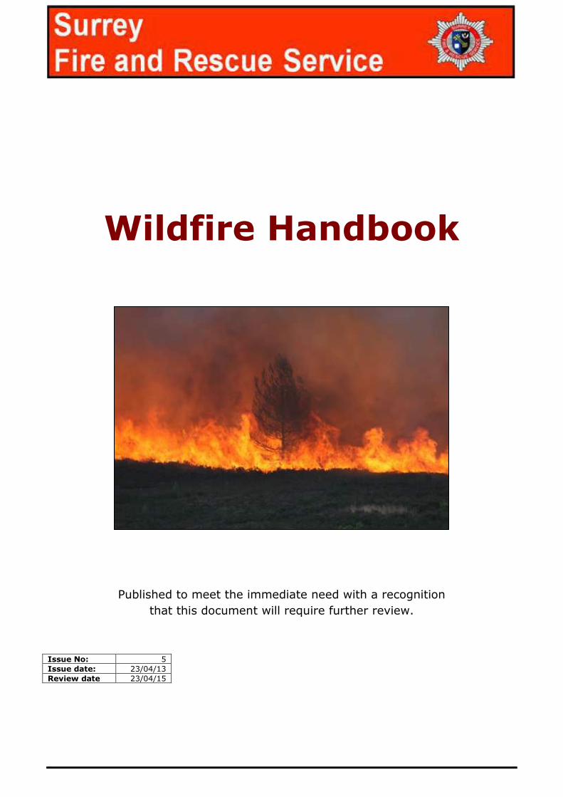
Wildfire Handbook
Published to meet the immediate need with a recognition
that this document will require further review.
Issue No: 5
Issue date: 23/04/13
Review date 23/04/15
Wildfire-v5-4.docx
Contents
1 Introduction ..................................................................... 1
2 Wildfire Behaviour ............................................................. 2
Wildfire triangle of fire ........................................................................ 2
Uniform fire development .................................................................... 2
3 Wildfire prediction system (WiPS) ........................................ 3
Wind................................................................................................. 4
Wind effects on fire spread .................................................................. 4
Slope ................................................................................................ 5
Slope effects on fire spread ................................................................. 5
Aspect .............................................................................................. 6
Aspect effects on fire spread ................................................................ 6
Flame Description .............................................................................. 7
Flame length/Control strategy.............................................................. 7
4 Wildfire Safety .................................................................. 8
LACES protocol .................................................................................. 8
Lookouts ........................................................................................... 9
Awareness......................................................................................... 9
Communication .................................................................................. 9
Escape routes .................................................................................... 9
Safety zones .................................................................................... 10
5 Wildfire Tactics ................................................................ 11
Direct Attack ................................................................................... 11
Indirect Attack ................................................................................. 14
Wildfire-v5-4.docx
6 Incident Command ........................................................... 17
Considerations ................................................................................. 17
Briefings ......................................................................................... 17
Communication ................................................................................ 18
Navigation ....................................................................................... 18
OS Grid Referencing ......................................................................... 19
Quick reference: Grid References ....................................................... 20
7 Partnership work .............................................................. 21
Sectorisation ................................................................................... 22
Incident Command Considerations ..................................................... 23
Sector Wildfire Officers ..................................................................... 24
Wildfire Officer Considerations ........................................................... 24
Summary ........................................................................................ 24
Appendix 1 ............................................................................ 25
Appendix 2 ............................................................................ 26
LACES safety protocol ....................................................................... 26
Appendix 3 ............................................................................ 27
Appendix 4 ............................................................................ 28
Incident command considerations ...................................................... 28
Appendix 5 ............................................................................ 29
Wildfire Terminology (Visual) ............................................................. 29
Appendix 6 ............................................................................ 30
Wildfire Terminology ......................................................................... 30
Incident notes ........................................................................ 32

[PROTECT]
Wildfire-v5-4.docx 1
1 Introduction
1.1 Wildfire is the generic term used to describe large uncontrolled fires occurring in the open in natural vegetation.
1.2 Wildfires are a growing issue in the south east and across the whole of the UK. They differ greatly to structural fires with a larger numbers of
environmental factors influencing how they develop.
1.3 Due to this and the vast variations in fuel types, Wildland/Urban interface, land topography, remote access, poor water supplies and rapid fire
development it makes tactical planning difficult and operational firefighting arguably one of the greater fire risks to crews who attend them.
1.4 Key to the success of wildfire control is an understanding of the fires behaviour in relation to the land, vegetation and weather, applying the
right firefighting tactics at the right time and in the right location.
1.5 Planning for wildfire incidents is an essential element to creating a
safe system of work. The provision of up to date topographical and risk information as well as sound understanding of factors
influencing a wildfire will allow Incident Commanders to undertake an appropriate dynamic risk assessment and develop a suitable
tactical plan.
1.6 This Wildfire handbook is intended for use by Fire and Rescue services as a
guide for wildfire suppression, and is a supporting document to the
regional training packages for Wildfire incidents. It provides guidance in operational techniques, safety protocol, situational briefings, incident
command considerations but also provides practical advice to all operational staff conducting wildfire operations

[PROTECT]
Wildfire-v5-4.docx 2
2 Wildfire Behaviour
Wildfire triangle of fire
These 3 main factors make up, along with fuel type and quantity, the Wildfire triangle of fire. When
these three factors (wind, slope and aspect) are in alignment it will
produce the most intense wildfires.
‘In alignment’ is the term used
to describe when the 3 main factors are all positively influencing the fire
Uniform fire development
Fires with no external influences
and the provision of a uniform fuel type and load will result in a fire
that will burn equally in all directions.
The nature of wildfires means that it will have many influences which result in abrupt changes in the
fires behaviour causing dangerous conditions if not monitored
[PROTECT]
Wildfire-v5-4.docx 3
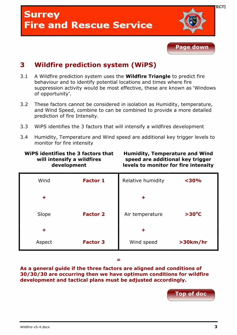
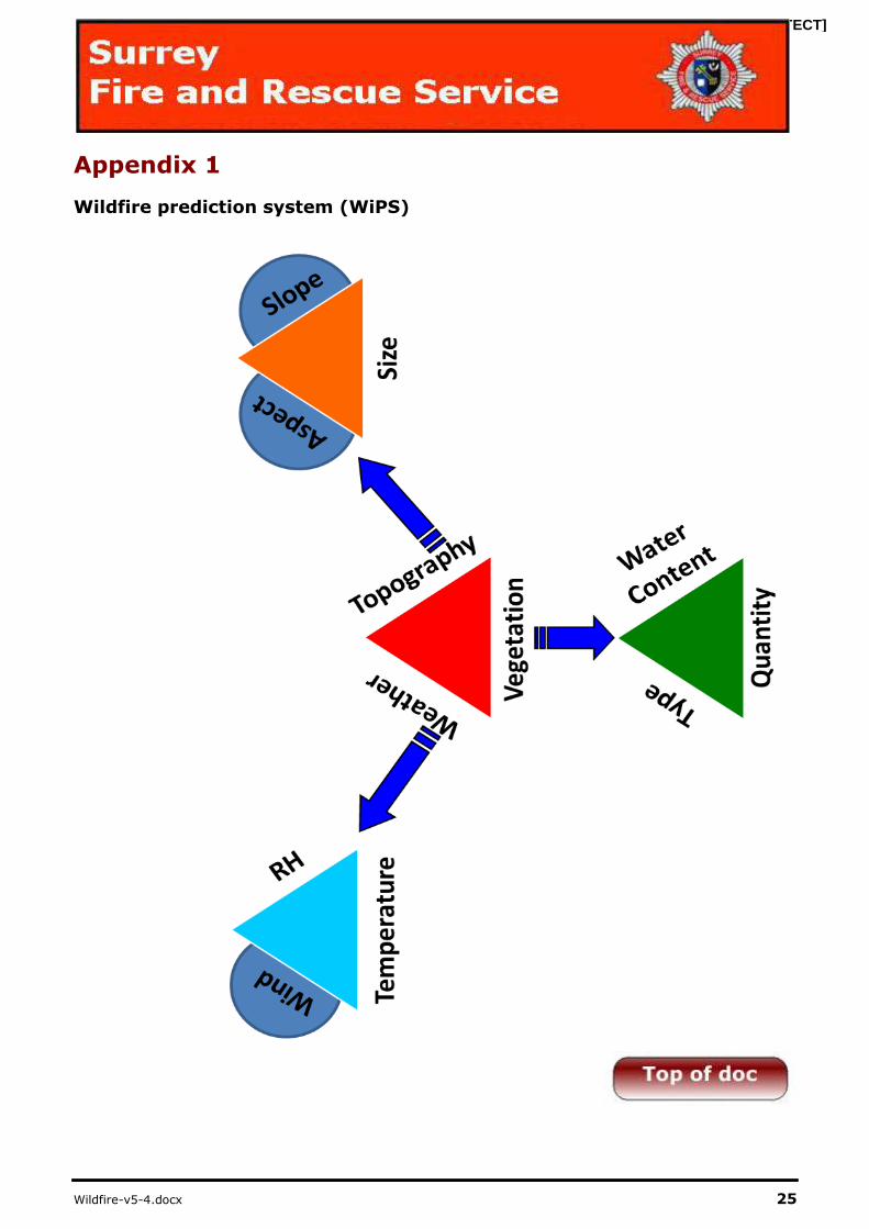
3 Wildfire prediction system (WiPS)
3.1 A Wildfire prediction system uses the Wildfire Triangle to predict fire behaviour and to identify potential locations and times where fire
suppression activity would be most effective, these are known as ‘Windows of opportunity’.
3.2 These factors cannot be considered in isolation as Humidity, temperature,
and Wind Speed, combine to can be combined to provide a more detailed prediction of fire Intensity.
3.3 WiPS identifies the 3 factors that will intensify a wildfires development
3.4 Humidity, Temperature and Wind speed are additional key trigger levels to
monitor for fire intensity
WiPS identifies the 3 factors that
will intensify a wildfires development
Humidity, Temperature and Wind
speed are additional key trigger levels to monitor for fire intensity
Wind Factor 1 Relative humidity <30%
+ +
Slope Factor 2 Air temperature >30oC
+ +
Aspect Factor 3 Wind speed >30km/hr
=
As a general guide if the three factors are aligned and conditions of 30/30/30 are occurring then we have optimum conditions for wildfire
development and tactical plans must be adjusted accordingly.
[PROTECT]
Wildfire-v5-4.docx 4
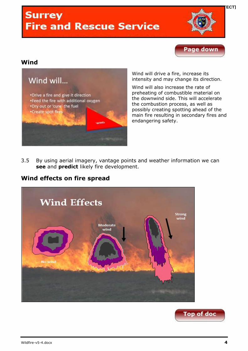
Wind
Wind will drive a fire, increase its intensity and may change its direction.
Wind will also increase the rate of
preheating of combustible material on the downwind side. This will accelerate
the combustion process, as well as possibly creating spotting ahead of the main fire resulting in secondary fires and
endangering safety.
3.5 By using aerial imagery, vantage points and weather information we can
see and predict likely fire development.
Wind effects on fire spread

[PROTECT]
Wildfire-v5-4.docx 5
Aspect
Slope
The rate of spread of fire is proportional to the slope.
Increases in 10° will double the
rate of fire spread.
Fire on a level surface traveling
at 10mph that reaches a slope of 10° will double its speed to 20mph.
Increases of a further 10° will double the speed again to
40mph.
Slope effects on fire spread

[PROTECT]
Wildfire-v5-4.docx 6
Aspect
Southerly facing slopes will experience higher temperatures, lower humidity and fuel moisture content.
Northerly aspects will normally be cooler, and will have higher humidity and fuel
moisture content. The extent of the variation will be determined by the time of year and severity of the slope.
Aspect effects on fire spread

[PROTECT]
Wildfire-v5-4.docx 7
Flame Description
The three flame descriptors give us an indicator of fire behaviour and our
actions when fighting wildfire.
Flame Height is used to describe the
intensity of a fire and is used to ascertain the required size of safety
zones and also the most appropriate escape routes.
Flame Length is the predicted measurement to determine the
adopted control strategy.
Flame Angle An indicator of the environmental factors affecting the fires development (Wind speed, Slope)
3.6 Safety zones (see Appendix 2 and 6) must be identified prior to deployment.
Flame length/Control strategy
Flame Length Control Strategy
< 1 m Can be attacked at the head or flanks
1m to 2.5 m Too intense for direct attack on the head by hand
crews. This fire is very dangerous
2.5 m to 3.5 m May present serious control problems (torching,
crowning and spotting)
>3.5m Crowning, spotting and major fire runs are
probable. Direct attack will probably be ineffective
[PROTECT]
Wildfire-v5-4.docx 8
4 Wildfire Safety
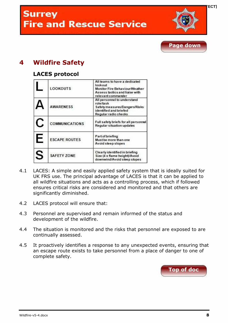
LACES protocol
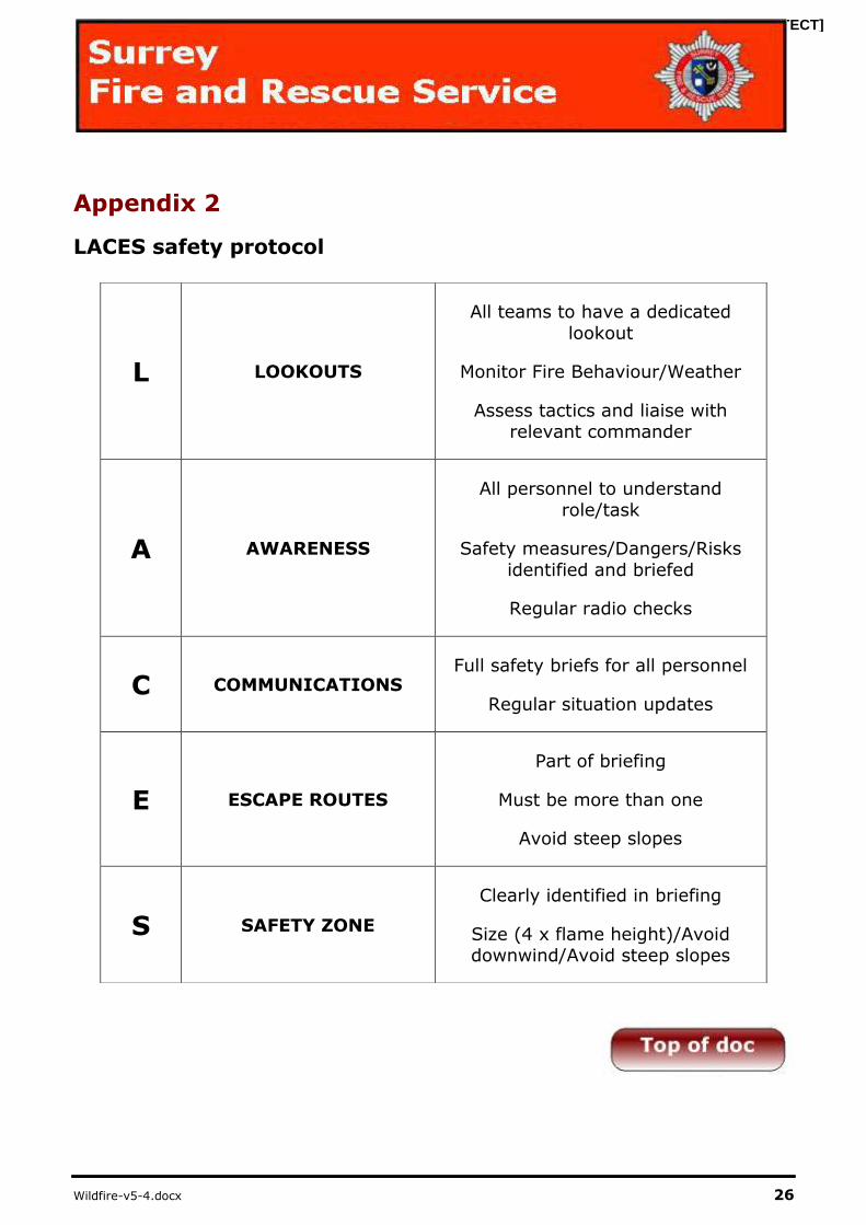
4.1 LACES: A simple and easily applied safety system that is ideally suited for
UK FRS use. The principal advantage of LACES is that it can be applied to all wildfire situations and acts as a controlling process, which if followed
ensures critical risks are considered and monitored and that others are significantly diminished.
4.2 LACES protocol will ensure that:
4.3 Personnel are supervised and remain informed of the status and development of the wildfire.
4.4 The situation is monitored and the risks that personnel are exposed to are continually assessed.
4.5 It proactively identifies a response to any unexpected events, ensuring that an escape route exists to take personnel from a place of danger to one of
complete safety.

[PROTECT]
Wildfire-v5-4.docx 9
Lookouts
4.6 A lookout is a person that has the responsibility to monitor fire behaviour and how this may impact on the activities of operational personnel under
their supervision. Lookouts at a wildfire incident can be appointed at crew, sector or incident level, depending on their training, expertise and
experience.
Awareness
4.7 Within the LACES protocol, AWARENESS concentrates on maintaining
alertness to the changes that may impair safety and ensuring that personnel remain fully informed. The deployment of Tactical Lookouts, and
the existence of Crew Lookouts, ensures that the dynamics of the situation can be constantly monitored.
Communication
4.8 At a wildfire incident where changes to fire behaviour can occur suddenly it is necessary to establish an effective communication system which includes
briefing crews prior to deployment.
4.9 FRS should be aware of areas where radio communications may be
ineffective and should make suitable alternative arrangements to ensure that contact can be maintained with personnel and teams working on the
fire ground. An inefficient communication system will seriously impair the effectiveness of any command structure.
4.10 Due to land topography we must ensure robust communications are established at the start of every wildfire incident. Therefore a secondary Airwave Talk group should aim to be established for fire
ground communications between ground crews and Incident
Command Units.
Escape routes
4.11 It is essential that personnel are aware of what action to take should an
emergency situation arise. As a priority, the Lookout must establish a safety zone and escape routes that will allow all team members to
withdraw to a location that offers a place of complete safety. Whenever
possible, it is good practise to have a primary and secondary escape route; in the event of the primary route being compromised the secondary one
can then be used.
[PROTECT]
Wildfire-v5-4.docx 10
Safety zones
4.12 A safety zone is a predetermined area where personnel can find refuge and safety from the effects of fire. It should be large enough to be used by all
members of the crew(s). Its size and location will depend on a number of factors but will generally be dictated by the size of the crews, the fuel
types, terrain, expected fire behaviour and prevailing weather conditions.
4.13 The minimum size of the safety zone should be a radius of four (4) times the flame height.
4.14 Information on the area to be used as a safety zone should be communicated to Sector or Operational Commanders, and Lookouts
if they have been deployed. The location of all identified Safety Zones should be relayed and recorded at the incident command
post.

[PROTECT]
Wildfire-v5-4.docx 11
5 Wildfire Tactics
Direct Attack
Head attack
Only to be considered with low
intensity fires, and carried out ‘In the Black’. Carrying out fire operations in unburnt vegetation is extremely
hazardous and should be avoided unless strict control measures are
employed.
Flank attack
The significant hazard associated with
flanked attacks is that wind and topography can affect the fire development and the flank fire can
develop into a head fire placing ground crews at significant risks.
Firefighting from the edge of un-burnt areas towards the black help
will help reduce fire spread but sufficient control measures must be adopted (see LACES)
[PROTECT]
Wildfire-v5-4.docx 12
Flank attack continued
Flank fires are approached from the heel
(Appendix 6) of the Fire. The left and right flanks are described when looking
from the Heel to the Head of the fire
Where possible attack both flanks simultaneously as this will result in
quicker knock down, reduce risk of weather changing the fire dynamics
and provide greater safety for fire crews
Tandem attack
Two vehicles can be used effectively to
knock down the fire and prevent re-ignition.
Appliance 1: moves along the fire front knocking down the fire and preventing it from spreading further.
Appliance 2: follows behind ensuring that the knocked down areas are
extinguished fully.
[PROTECT]
Wildfire-v5-4.docx 13
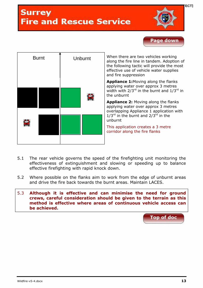
When there are two vehicles working along the fire line in tandem. Adoption of
the following tactic will provide the most effective use of vehicle water supplies and fire suppression
Appliance 1:Moving along the flanks applying water over approx 3 metres
width with 2/3rd in the burnt and 1/3rd in the unburnt
Appliance 2: Moving along the flanks
applying water over approx 3 metres overlapping Appliance 1 application with
1/3rd in the burnt and 2/3rd in the unburnt
This application creates a 3 metre corridor along the fire flanks
5.1 The rear vehicle governs the speed of the firefighting unit monitoring the
effectiveness of extinguishment and slowing or speeding up to balance effective firefighting with rapid knock down.
5.2 Where possible on the flanks aim to work from the edge of unburnt areas and drive the fire back towards the burnt areas. Maintain LACES.
5.3 Although it is effective and can minimise the need for ground crews, careful consideration should be given to the terrain as this
method is effective where areas of continuous vehicle access can
be achieved.
Burnt Unburnt

[PROTECT]
Wildfire-v5-4.docx 14
Indirect Attack
Control lines
Used at high intensity fires, where
firefighting close to the fires edge may be dangerous.
Indirect attack is where firefighting is
applied away from the fires edge. The purpose is normally to contain a fire
within a chosen boundary. As this technique is applied away from the fire front, this can often be a much safer way
of fighting a fire.
5.4 Considerations when constructing control lines:
5.5 Creating the control line too close to the fire line risks crews due to insufficient time to create an adequate fire line exposing crews to intense
fire conditions.
5.6 Creating the fire line too far in advance leaves risk of changing weather
conditions causing the fire line to miss the control line completely
5.7 Offensive use of a control line may pose a significant number of risks and
the following must be considered:
a) Areas consisting of large numbers of Wildland urban interfaces
b) Complex infrastructure
c) High unmanaged fuel loads
d) Extreme weather conditions (see page 4)
5.8 Spotting: Firefighting crews on the control line may be put at risk if spotting occurs beyond the control line causing further fire spread
5.9 Ensure full use of Wildfire Officers and Local Land Managers to provide the Incident Commander with projected fire spread and
windows of opportunity for effective fire suppression
[PROTECT]
Wildfire-v5-4.docx 15
5.10 It must be understood however that from a view point of the incident commander Indirect attack can be used as an offensive and defensive tool.
5.11 Offensive: The indirect attack to create a fire break is based on the likely development of the fire and is based on your primary operational plan
5.12 Defensive: The indirect attack is used in a precautionary way away from the fire in the eventuality that fire development changes and your primary
operational plan becomes ineffective.
5.13 Decisions on where to create the control line should be based on knowledge and understanding of the fires current and future behaviour
through the “Wildfire Prediction System” and the wildfire officer who will be providing the incident commander with knowledge of the fire scene.
(Appendix 1)
5.14 Use of foam can be used to create an effective fire break by applying a
foam blanket to restrict flammable fuel and widen fire breaks; crews should consider fuel types, fuel density and fire intensity when deciding
width of foam blanket what foam type to apply. This will be more effective when used in conjunction with other manual/mechanical forms of control
line construction.
5.15 Ensure that crews observe beyond the fire line once the fire reaches the
control line to extinguish spotting that may occur.
5.16 Once the fire has reached the control line efforts should be focused on
maintaining the effectiveness of the line while the fire intensity is reduced
and importantly controlling any spotting beyond the control line.
5.17 Operational back burning is not currently used as a method of
control line creation due the abnormal level of risk; however
similar results can be achieved by use of CAFS, hand tools, heavy
machinery as well as use of existing fire breaks.
5.18 Consider using these techniques together to create an effective
control line.
[PROTECT]
Wildfire-v5-4.docx 16
Damping Down
5.19 Once the fire is under control through Direct or Indirect attack it is
essential that damping down is carried out effectively to prevent re-ignition
Key Principles
5.20 Damp down the high-risk areas first
5.21 Damp down the entire area on small fires
5.22 On large areas ensure that damping down is carried out around the entire
perimeter and that it is far enough into the black to eliminate the chance of spotting or re-ignition given a change in conditions
5.23 Search for and eliminate smouldering spot fires
5.24 Smouldering materials the green side of the fire line must be extinguished
and/or thrown onto the black
5.25 Particular care should be taken in areas of peat to avoid smouldering
ground fires, which may become a surface fire several hours later.
5.26 Consider use of foam and/or wetting agents
5.27 Consider use of thermal image camera
5.28 When damping down is complete, carry out a further inspection of the area
to ensure that no hot spots remain
5.29 Where appropriate, damping down may be handed over to the land
owner or partner agency once a dynamic risk assessment has been performed and this has been agreed through the Incident
Commander
[PROTECT]
Wildfire-v5-4.docx 17
6 Incident Command
Considerations
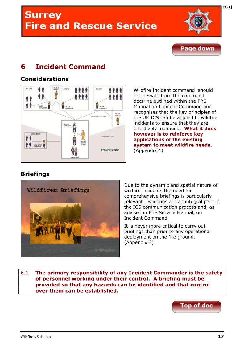
Wildfire Incident command should not deviate from the command doctrine outlined within the FRS
Manual on Incident Command and recognises that the key principles of
the UK ICS can be applied to wildfire incidents to ensure that they are
effectively managed. What it does however is to reinforce key applications of the existing
system to meet wildfire needs. (Appendix 4)
Briefings
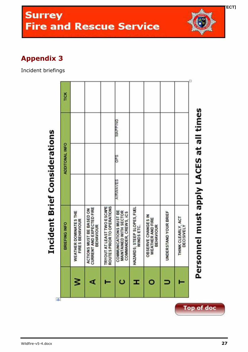
Due to the dynamic and spatial nature of wildfire incidents the need for
comprehensive briefings is particularly relevant. Briefings are an integral part of
the ICS communication process and, as advised in Fire Service Manual, on Incident Command.
It is never more critical to carry out briefings than prior to any operational
deployment on the fire ground. (Appendix 3)
6.1 The primary responsibility of any Incident Commander is the safety of personnel working under their control. A briefing must be
provided so that any hazards can be identified and that control
over them can be established.
[PROTECT]
Wildfire-v5-4.docx 18
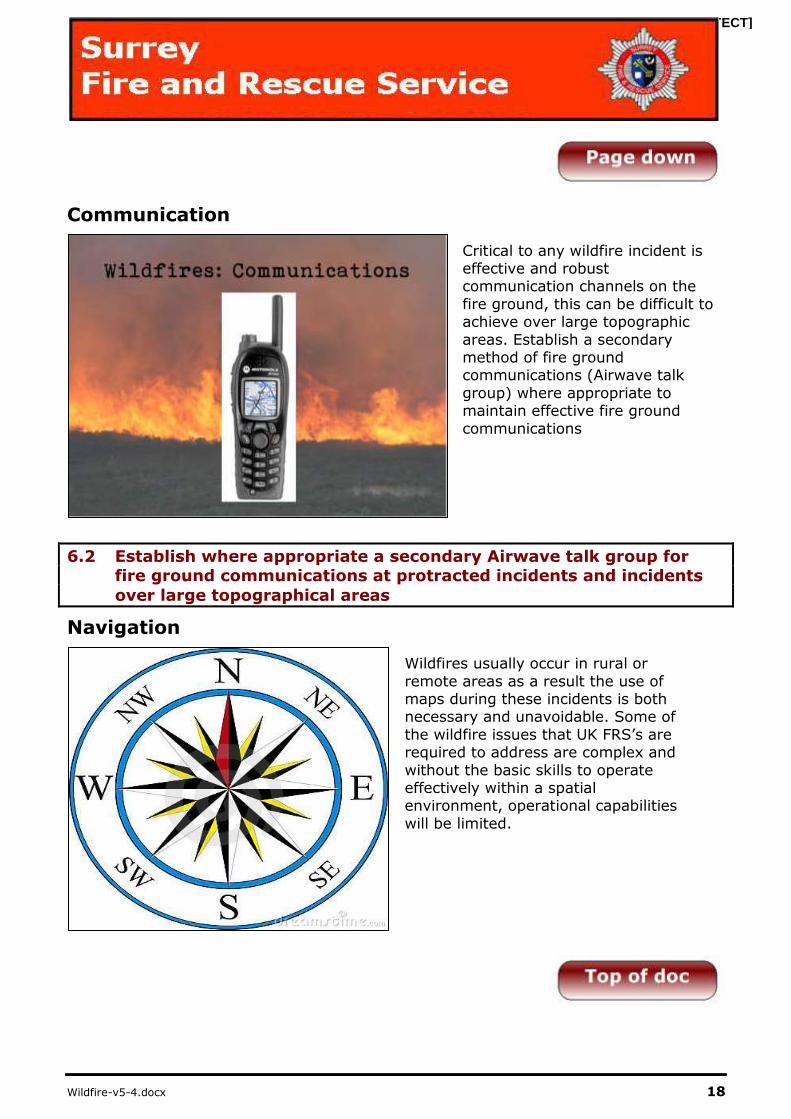
Communication
Critical to any wildfire incident is effective and robust communication channels on the
fire ground, this can be difficult to achieve over large topographic
areas. Establish a secondary method of fire ground communications (Airwave talk
group) where appropriate to maintain effective fire ground
communications
6.2 Establish where appropriate a secondary Airwave talk group for fire ground communications at protracted incidents and incidents
over large topographical areas
Navigation
Wildfires usually occur in rural or
remote areas as a result the use of maps during these incidents is both necessary and unavoidable. Some of
the wildfire issues that UK FRS’s are required to address are complex and
without the basic skills to operate effectively within a spatial environment, operational capabilities
will be limited.

[PROTECT]
Wildfire-v5-4.docx 19
OS Grid Referencing
6.3 It is essential that all movement on the fire ground is communicated with incident command in a standardised and universally recognised format. All
crew are to communicate, navigate and identify key location based intelligence via OS Grid Referencing system.
6.4 Mapping is available on all key risk sites and further OS mapping should be made available to:
a) Wildfire Officers
b) Incident Command Unit (ICU)
c) All specialist off road vehicles
6.5 Appliances should aim to update your location with Command
Support every 20-30mins
[PROTECT]
Wildfire-v5-4.docx 20
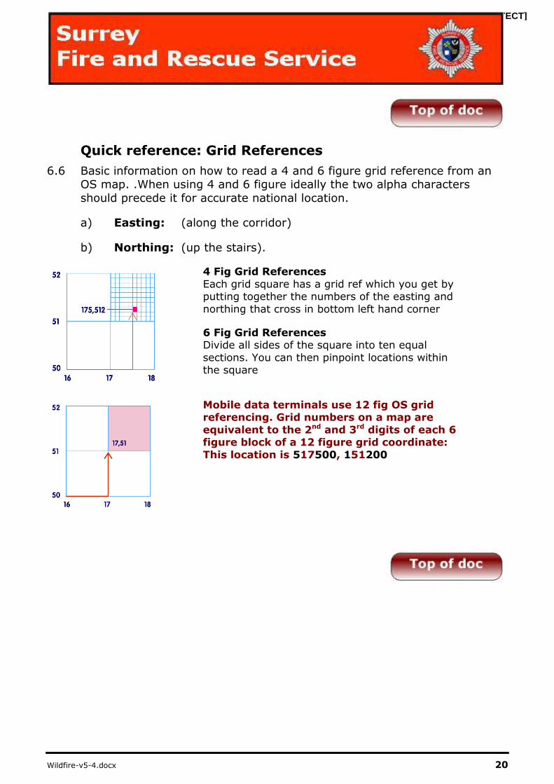
Quick reference: Grid References
6.6 Basic information on how to read a 4 and 6 figure grid reference from an OS map. .When using 4 and 6 figure ideally the two alpha characters
should precede it for accurate national location.
a) Easting: (along the corridor)
b) Northing: (up the stairs).
4 Fig Grid References
Each grid square has a grid ref which you get by putting together the numbers of the easting and
northing that cross in bottom left hand corner
6 Fig Grid References Divide all sides of the square into ten equal
sections. You can then pinpoint locations within the square
Mobile data terminals use 12 fig OS grid referencing. Grid numbers on a map are
equivalent to the 2nd and 3rd digits of each 6 figure block of a 12 figure grid coordinate:
This location is 517500, 151200
[PROTECT]
Wildfire-v5-4.docx 21
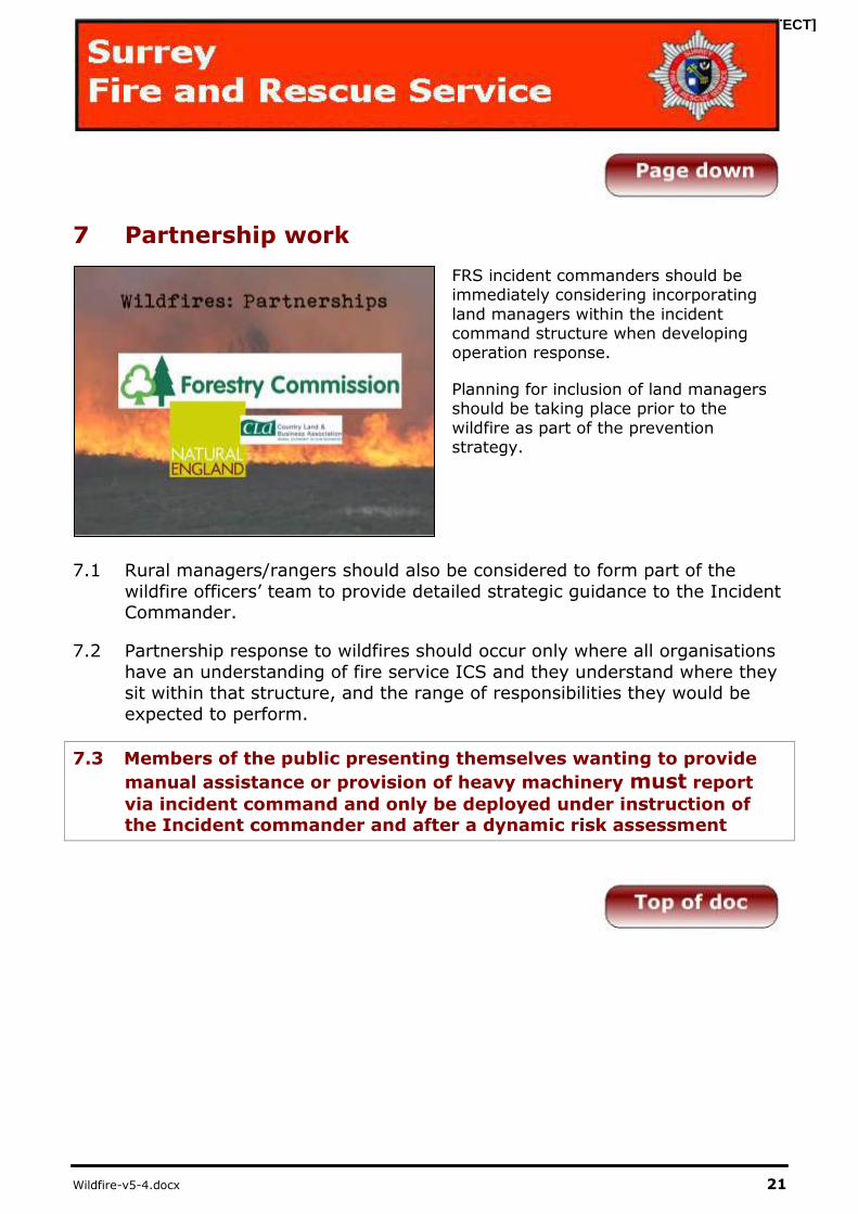
7 Partnership work
FRS incident commanders should be immediately considering incorporating
land managers within the incident command structure when developing operation response.
Planning for inclusion of land managers should be taking place prior to the
wildfire as part of the prevention strategy.
7.1 Rural managers/rangers should also be considered to form part of the
wildfire officers’ team to provide detailed strategic guidance to the Incident Commander.
7.2 Partnership response to wildfires should occur only where all organisations
have an understanding of fire service ICS and they understand where they sit within that structure, and the range of responsibilities they would be
expected to perform.
7.3 Members of the public presenting themselves wanting to provide
manual assistance or provision of heavy machinery must report
via incident command and only be deployed under instruction of the Incident commander and after a dynamic risk assessment

[PROTECT]
Wildfire-v5-4.docx 22
Sectorisation
7.4 With the dynamic nature of wildfires, and the large geographical areas they
cover, sectorisation of the wildfire can be difficult to achieve.
7.5 An outer perimeter created around the fire based on predicted fire spread
can then be widened if the fire develops, potentially leaving sectors within it intact
7.6 Internal sectorisation can be as simple as dividing the heel and head of the fire (sectors 1 and 3) as the incident develops those sectors can be divided
again (sectors 2 and 4) based on topography or risk (sector 5 life risk).
[PROTECT]
Wildfire-v5-4.docx 23
7.7 It is widely suggested that an effective way to achieve this is via OS map. Draw a circle around the incident far enough away to include future fire
development, this circle can then be divided into sectors according to:
a) Sections of the fire
b) Features of the landscape c) Fire spread
d) Life Risk
e) Property Risk f) Established Fire Control lines (Appendix 6)
Incident Command Considerations
7.8 What is the fire’s behaviour and its future development?
7.9 Have effective Communications been established?
7.10 Have we established communication with the land owner?
7.11 Do I have the appropriate equipment and appliances to carryout fire
suppression?
7.12 What are the appropriate tactics to be employed?
7.13 What suppression methods to be used?
7.14 The deployment of resources on the fire ground.
7.15 The associated risks and the control measures to be instigated during the incident.
7.16 Provide advice or practical guidance in relation to map reading or navigational issues.
7.17 To gather and analyse operational intelligence.

[PROTECT]
Wildfire-v5-4.docx 24
Sector Wildfire Officers
7.18 Wildfire officers may be deployed in each sector of the fire to provide tactical support and help coordinate:
7.19 Operating as Team, Sector or Incident lookouts.
7.20 Giving tactical support to sector commanders.
7.21 Form teams able to construct control lines
Wildfire Officer Considerations
7.22 Personnel performing a wildfire advisory role should have the knowledge
and understanding to provide information on issues including:
7.23 Fire behaviour and its future development.
7.24 The appropriate tactics to be employed.
7.25 The suppression methods to be used.
7.26 The deployment of resources on the fire ground.
7.27 The associated risks and the control measures to be instigated during the
incident.
7.28 Provide advice or practical guidance in relation to map reading or
navigational issues.
7.29 To gather and analyse operational intelligence.
7.30 Giving tactical support to Incident and operational commanders
7.31 Wildfire officers should be deployed for providing specialist advice to the
incident command structure. Wildfire officers should not be tasked with any
other role during operations as unmonitored fire development poses significant risk to operational crews.
Summary
7.32 This information is designed to act as a guide to a safe, structured
approach to wildfire management. Its content is beneficial to both operational crews and incident commanders.
[PROTECT]
Wildfire-v5-4.docx 25
Appendix 1
Wildfire prediction system (WiPS)
[PROTECT]
Wildfire-v5-4.docx 26
Appendix 2
LACES safety protocol
L LOOKOUTS
All teams to have a dedicated
lookout
Monitor Fire Behaviour/Weather
Assess tactics and liaise with relevant commander
A AWARENESS
All personnel to understand
role/task
Safety measures/Dangers/Risks
identified and briefed
Regular radio checks
C COMMUNICATIONS Full safety briefs for all personnel
Regular situation updates
E ESCAPE ROUTES
Part of briefing
Must be more than one
Avoid steep slopes
S SAFETY ZONE
Clearly identified in briefing
Size (4 x flame height)/Avoid downwind/Avoid steep slopes
[PROTECT]
Wildfire-v5-4.docx 27
Appendix 3
Incident briefings

[PROTECT]
Wildfire-v5-4.docx 28
Appendix 4
Incident command considerations
[PROTECT]
Wildfire-v5-4.docx 29
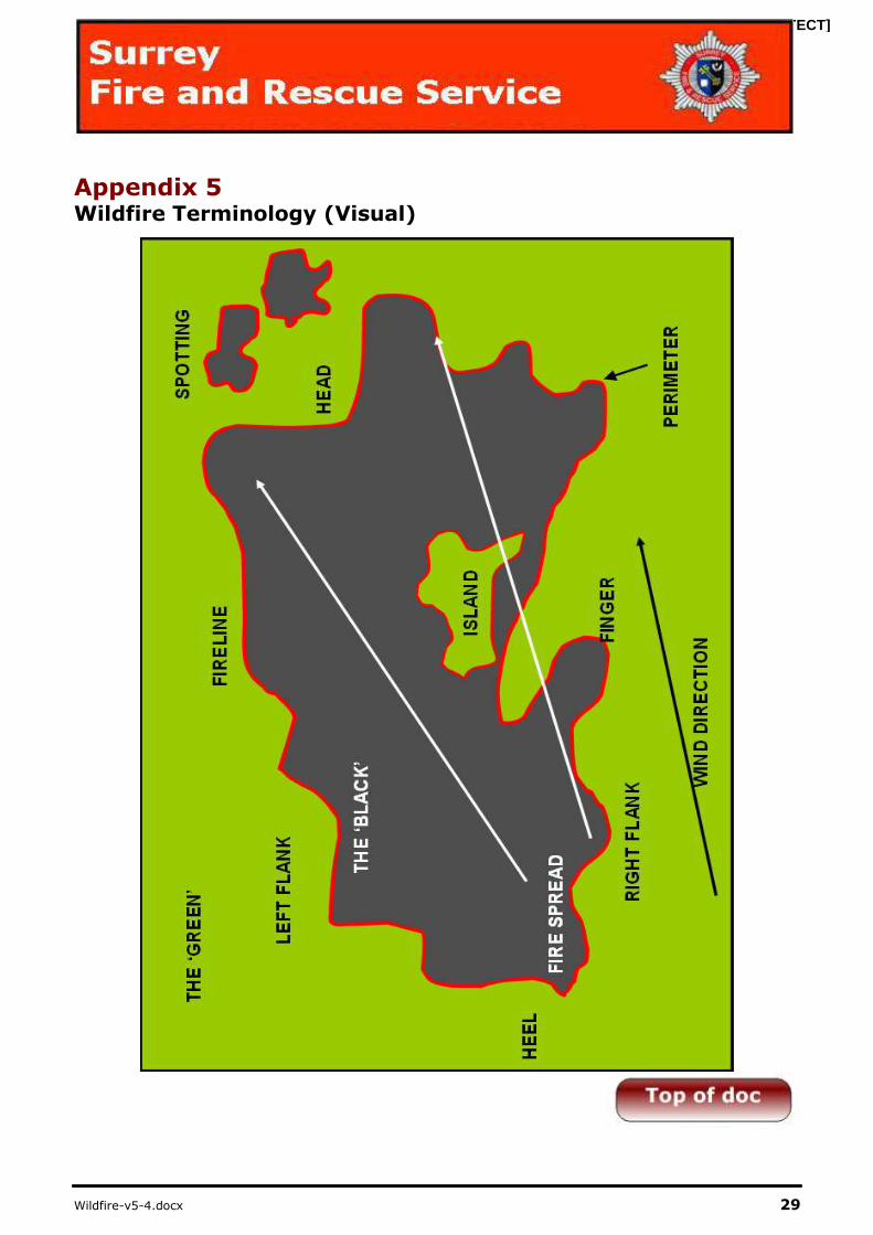
Appendix 5 Wildfire Terminology (Visual)
[PROTECT]
Wildfire-v5-4.docx 30
Appendix 6
Wildfire Terminology
Head: The part of a wildfire with the greatest forward rate of spread, also known as the Fire front. Often burns intensively and at high speed. Controlling the head
and preventing the development of new heads are critical to suppressing a wildfire.
Heel: The end opposite the Head. Fire at the heel usually burns into any prevailing wind and therefore is generally a low intensity fire. This is where the
fire is easier to control.
Flanks: The flanks are the sides of a wildfire, roughly parallel to the main
direction of fire spread. The identification of the flanks is critical and this is always achieved looking from the heel towards the head. Flanks may burn
rapidly and can become the head with a change in wind direction.
Fingers: Typically long, narrow strips of fire extending from the main body.
Often indicative of an area of mixed vegetation where the fire spreads rapidly in light fuels but is slowed by heavier fuels, thus providing an inconsistent rate of
spread.
Fire Perimeter: This is the outer boundary of the fire or burned area.
Spotting: This is the creation of small fires in advance of the main fire. Embers
blown by convection currents/wind may ignite vegetation that has been preheated by the main fire. Spotting presents a significant hazard as these fires
can rapidly develop, potentially trapping fire-fighters on the Fire line.
Fire line: An area of active firefighting activity
Anchor Point: A secure point from which fire suppression activity should commence. Typical anchor points are roads, tracks, ponds and streams.
Green area: This is an area of unburned fuels adjacent to the fire. This is a hazard area, the severity of the risk being dictated by the type of vegetation,
moisture content etc.
[PROTECT]
Wildfire-v5-4.docx 31
Black area: This is an area in which fire has consumed the fuel. The black area is relatively safe (as opposed to the green area) although hot spots, smouldering
snags (trees etc) and potentially unstable ground may all be present.
Safety zone: An area identified that will provide refuge from the fire with
minimal risk of injury. This area should measure at least 4 times the predicted flame height of the surrounding fuel load.
Control line: Control lines include any constructed or natural barrier (known as firebreaks) or treated fire perimeter (e.g. foam blanket)
Wildland Urban Interface: An area where the built environment meets an area of vegetation. This may be along a large front, for example where a housing
estate backs on to common land, or isolated houses in woodland. This type of
scenario presents additional pressures for an Incident Commander and may require a more aggressive type of firefighting.
Torching: Where a surface fire ignites the foliage of a tree or bush and this becomes rapidly engulfed in fire. This may lead to crowning.
Crowning: This is the advance of a fire from tree top, to tree top independently of the surface fire. This fire is very fast moving and very dangerous.
Surface Fire: Burns in grasses and shrubs and will often move rapidly, completely consuming the fuel load
Ground Fire: Burns in organic soils such as peat and includes root systems and natural litter. Slow, intense burning that may be very deep seated.
[PROTECT]
Wildfire-v5-4.docx 32
Incident notes


