Weather Summary: Friday, July 23, 2021 1000 hrs. Mary Butwin – NWS Seattle Today/Tonight: Conditions overall will remain very dry for the east side with humidity generally running around 10-20%, particularly for the southerly facing slopes. Many lower inland elevations west of the Cascades are seeing humidity into the 30-40% range as little marine air made it inland last night. Breezy conditions are expected on the east side of the Cascades, particularly through the north central region, as a very weak front moves through the area. Generally weak instability on the East side of the state with mixing heights 5-10k feet. Winds generally ease overnight. Good to excellent humidity recovery expected for the west side while generally moderate recovery conditions will set up on the east side tonight. The higher terrain in the Blue and Selkirk Mountains. Please refer to local NWS warnings and forecasts for specific details. *More information below* Burn Restrictions/Announcements: July 22, 2021: Fire Danger Ratings, Industrial Fire Precaution Levels Rise in Eastern WA The Washington State Department of Natural Resources (DNR) and its partners are increasing Fire Danger Ratings (FDRs) and Industrial Fire Precaution Levels (IFPLs) on DNR-protected lands in parts of eastern Washington. Effective 12:01 a.m., Friday, July 23: Fire danger will increase from Very High to Extreme in the Chelan, Foothills, Highlands, Kaniksu, Lower Yakima, Methow, Upper Yakima and Valley FDRAs. Industrial Fire Precaution Level (IFPL) will increase from Level 2 to Level 3 in zone: 680. Read the full announcement here. Wildfire Situation Update Date: July 23, 2021 For DNR’s current fire situation status please visit: http://fireinfo.dnr.wa.gov/ NW Preparedness Level: 5 National Preparedness Level: 5 NW T2 IMT Rotation: NW Team 6 (Sheldon) DNR IA Activity: Light
Transcript
Weather Summary:
Friday, July 23, 2021
1000 hrs.
Mary Butwin – NWS Seattle
Today/Tonight:
Conditions overall will remain very dry for the east side with humidity generally running around
10-20%, particularly for the southerly facing slopes. Many lower inland elevations west of the
Cascades are seeing humidity into the 30-40% range as little marine air made it inland last night.
Breezy conditions are expected on the east side of the Cascades, particularly through the north
central region, as a very weak front moves through the area. Generally weak instability on the
East side of the state with mixing heights 5-10k feet.
Winds generally ease overnight. Good to excellent humidity recovery expected for the west
side while generally moderate recovery conditions will set up on the east side tonight. The higher
terrain in the Blue and Selkirk Mountains.
Please refer to local NWS warnings and forecasts for specific details. *More information below*
Burn Restrictions/Announcements:
July 22, 2021: Fire Danger Ratings, Industrial Fire Precaution Levels Rise in Eastern WA
The Washington State Department of Natural Resources (DNR) and its partners are increasing Fire Danger Ratings (FDRs) and Industrial Fire Precaution Levels (IFPLs) on DNR-protected lands in parts of eastern Washington. Effective 12:01 a.m., Friday, July 23:
Fire danger will increase from Very High to Extreme in the Chelan, Foothills, Highlands, Kaniksu,
Lower Yakima, Methow, Upper Yakima and Valley FDRAs.
Industrial Fire Precaution Level (IFPL) will increase from Level 2 to Level 3 in zone: 680.
Region Reports: Note that count of new IA fires and acres is now daily Monday-Friday, with
weekend activity included on Mondays. Large Fires are defined as 100 acres in timber or 300 acres in grass.
Northeast
New Fires 5 IA fires for 164.8 acres.
Resources Available
In Region Avail for Out of Region Engines 26 Engines 0
Crews 2 Crews 0
Notes: 7 active large fires. IMT3 and resources prepositioned for Nk’Mip available as surge resource. 5 dozers on standby.
Northwest
New Fires 1 IA fire for 0.5 acre.
Resources Available
In Region Avail for Out of Region
Engines 4 Engines 1 Crews - Crews -
Notes: 1 HEQB and 1 FFT1 available for out-of-region.
Olympic
New Fires 1 IA fire for 0.25 acre.
Resources Available
In Region Avail for Out of Region
Engines 4 Engines 0 Crews 3 Crews 0
Notes: Mechanic and HEQBt available.
Pacific Cascade
New Fires 2 IA fires for 0.75 acre.
Resources Available
In Region Avail for Out of Region Engines 10 Engines 3
Crews 2 Crews 0 Notes:
Southeast
New Fires 0 IA fires.
Resources Available
In Region Avail for Out of Region
Engines 29 Engines 0 Crews 1 Crews 0
Notes: 3 active large fires in region. 5 dozers on standby. Estes strike team in Wenatchee, NC/KY strike team in Dayton, 1 NW engine in Yakima. Ahtanum crew on short-term lend/lease to Chuweah. SE IMT3 Team 1 mobilizing to Steptoe Canyon, Team 2 mobilizing to Northrup. Critical needs: two ICT4/TFLDs, fire investigator, HEQB, ENGB.
South Puget New Fires 0 IA fires.
Resources
Available
In Region Avail for Out of Region
Engines 7 Engines 0
Crews 3 Crews 0
Notes:
Recent Fire Activity Snapshot: See: http://fireinfo.dnr.wa.gov/
ResponsesFires and false alarms on any jurisdiction where DNR dispatched resources
DNR Responses Response Acres
Eastside 941 150158.12
Westside 327 243.86
Total 1268 150401.98
DNR Protection FiresFires on or those threatening DNR-protected lands
DNR Fires DNR Acres
Eastside 548 106222.92
Westside 235 239.06
Totals 783 106461.98
Fire CausesNumber of DNR fires by general cause category
Fire LocationsNew fires shown in red (last 72hrs), older fires in black
Ten Year (Year-to-Date) Fire StatisticsThese values represent the total number of DNR fires and acres burned over the last ten years from January 1 to the date of this report. Note that the average is calculated
on 2011-2020 numbers to allow for editing/finalizing of 2021 statistics.
Report created from EIRS on: Fri Jul 23 06:01:21 2021
Data Disclaimer: Statistics for DNR Wildfire Reports are compiled in DNR's internal Emergency Incident Response Statistics (EIRS) software from the regionaldispatch offices. Statistics are subject to editing, and may vary throughout the season until finalized at the end of the year.
For questions about these statistics, please email [email protected].
Washington State Daily Situation Weather BriefFriday, July 23, 20211000 hrs.Mary Butwin – NWS SeattleImages courtesy National Weather Service and NOAA Global Systems Laboratory
Today/Tonight:Conditions overall will remain very dry for the east side with humidity generally running around10-20%, particularly for the southerly facing slopes. Many lower inland elevations west of theCascades are seeing humidity into the 30-40% range as little marine air made it inland last night.Breezy conditions are expected on the east side of the Cascades, particularly through the northcentral region, as a very weak front moves through the area. Generally weak instability on theEast side of the state with mixing heights 5-10k feet.
Winds generally ease overnight. Good to excellent humidity recovery expected for the west sidewhile generally moderate recovery conditions will set up on the east side tonight. The higherterrain in the Blue and Selkirk Mountains.
Please refer to local NWS warnings and forecasts for specific details.
Satellite image from 0731 hrs. today
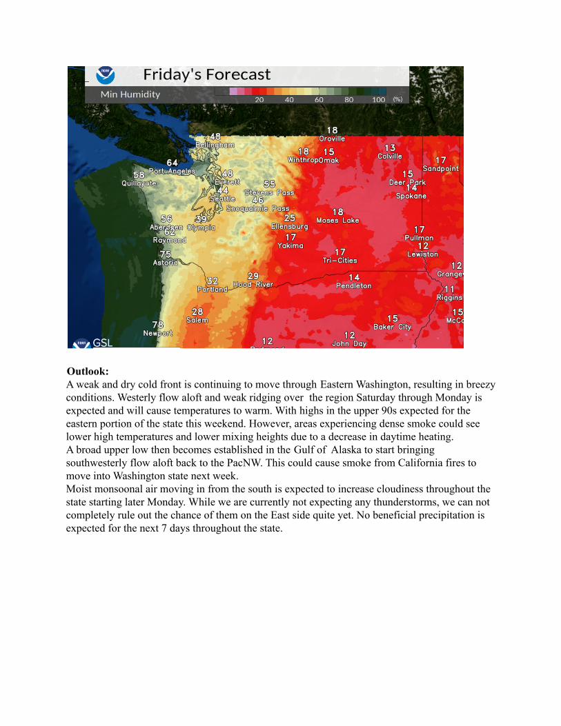
Outlook:A weak and dry cold front is continuing to move through Eastern Washington, resulting in breezyconditions. Westerly flow aloft and weak ridging over the region Saturday through Monday isexpected and will cause temperatures to warm. With highs in the upper 90s expected for theeastern portion of the state this weekend. However, areas experiencing dense smoke could seelower high temperatures and lower mixing heights due to a decrease in daytime heating.A broad upper low then becomes established in the Gulf of Alaska to start bringingsouthwesterly flow aloft back to the PacNW. This could cause smoke from California fires tomove into Washington state next week.Moist monsoonal air moving in from the south is expected to increase cloudiness throughout thestate starting later Monday. While we are currently not expecting any thunderstorms, we can notcompletely rule out the chance of them on the East side quite yet. No beneficial precipitation isexpected for the next 7 days throughout the state.
Washington DNR Fuels Status 7/23/2021
Date Issued: 7/23/2021
Vaughn Cork Fuels Analyst Narrative: The holdover threat from thunderstorms in the eastern counties should be essentially gone by this point. Connectivity issues with the GOES West satellite caused several RAWS stations to fail to report. Some westside indices were especially thrown off. The area of most concern over the weekend is the northern tier from the Methow valley to the Idaho border where fuel conditions are most severe. Eastern Washington – Todays cooler weather will help to decrease intensity a bit, and that should keep through Saturday. By Sunday with the heat and breeze back, we will see fire danger reverse and begin climbing again into the middle of next week. Fire activity can subsequently increase. Expect extreme fire behavior for any new start and plan tactics accordingly. Long range spotting up to and exceeding 1 mile has been reported, and transitioning from surface to canopy is common. Western Washington – Onshore flow is expected to continue through the middle of next week at least, keeping the large fire potential low overall. Low afternoon RH values from Olympia, down to the Oregon border will create more active fire along the southern I-5 corridor today. Those RH values look to moderate into the weekend decreasing that threat. Exposed sites can burn with high intensity and stumps and deep duff will pose mopup problems.
Severe Fire Danger Index with fires over 200 acres shown and VIIRS/MODIS hot spots. (wildfiresafe.technosylva.com)
Washington DNR Fuels Status 7/23/2021
Date Issued: 7/23/2021
ERC Friday 7/23/2021
ERC Saturday 7/24/2021
Washington DNR Fuels Status 7/23/2021
Date Issued: 7/23/2021
ERC Sunday 7/25/2021 Fuel Conditions by Fire Danger Rating Area:
FDRA Fire Danger ERC (±) BI (±) Live Fuel Avg (±) 100 hour(±) 1000 Hr(±) Methow EXTREME 98 (+1) 96 (-2) 80(-10) 8(-1)
Chelan EXTREME 95(+1) 95 (+3) 140(+50) 11(+1) Upper Yakima Very High 96(+1) 95(-3) 125(+5) 10(0) Lower Yakima High 89(0) 83(+5) 140(0) 12(0)
Cascade South Moderate 93(+4) 90(+1) 16(0) 17(0) Cascade Central High 96(+6) 97(+6) 16(-1) 17(0) Cascade North Moderate 88(0) 89(0) 18(0) 19(0)
Lowlands South High 96(+4) 96(+4) 16(-1) 17(0) Lowlands Central Moderate 83(0) 86(+20) 19(0) 19(+1)
Lowlands North Moderate 87(+2) 90(+5) 18(0) 18(0) **Note, indicated Adjective Fire Danger rating may not be the same as the publicly posted fire danger. Blue Mountains FDRA is part of a different FDOP and results are not posted in percentiles, all other ERC and BI values are in percentiles.
Washington DNR FIRE Air Operations Daily Operational Plan 7/23/2021 1:28:44 PM Page: 1
Washington Department of Natural Resources Wildfire Division – Aviation – Air Operations Daily Air Operations Plan – Lasted Updated: 7/23/2021
Date(s) covered: 7/23/2021 Reduced flight hours on multiple aircraft in effect for pilot management and maintenance flows. Plan accordingly. Aircraft ordered for teams and not engaged by 1200 may be re-assigned as necessary to support other large incidents or IAs as needed. DNR IA Only designated are required to be replaced by another aircraft ASAP. Order Priorities for today: 1st As Always Initial Attack > Set at 0830 Operations call
ALERT ADO TO ANY FUEL ISSUES AT AIRBASES. LESS THAN 48 HOURS OF FUEL ON SITE. TANDEM DESIGNATED DNR/CONTRACTOR AIRCRAFT REQUIRED TO BE DISPATCHED TOGETHER UNLESS UNABLE DUE TO AIRCRAFT AUTHORIZATIONS (NON_FEDERAL CARDED)
Air Operations Points of Contact & Coordination Aircraft Duty Officer (ADO) Dave Ritchie – 1st Primary ADO 360-528-9011 or [email protected] / Chief of Air Operations
Washington DNR FIRE Air Operations Daily Operational Plan 7/23/2021 1:28:44 PM Page: 2
WA DNR FIRE AIR OPS - DAILY AIRCRAFT STATUS 7/23/2021
Dispatching Procedures: (False Alarm code for DNR Helicopters & Air Attack on DNR Protections only PI 223-IZT) (False Alarm code from DNR Helicopters & Air Attack on Non-DNR Protections PI 223-IAL) Contact assigned HMGB. Additional aircraft request or out of region aircraft request contact Aircraft Duty Officer (ADO).
Minimum information needed for launch of DNR Helicopters for IA and/or Air Attack for Reconnaissance includes: Location of fire Repeater in use for flight following
Additional information if known: (Not required for launch of DNR owned assets) Air to Ground Frequency Incident Name/Number Ground Contact if any Primary Air to Air All other TARO information may be passed in flight if known. Please complete TARO and email to HMGB/Flight Manager when available.
1 Moses Lake (MWH) T-152 1st up Tanker for DNR & State Fires
30 minutes WD/CWICC CV 580 1000-2000. DOI, State, and all other non-federal lands.
SUNRISE-SUNSET
Washington DNR FIRE Air Operations Daily Operational Plan 7/23/2021 1:28:44 PM Page: 5
OLYMPIA
YAKIMA
DEER PARK
Washington DNR FIRE Air Operations Daily Operational Plan 7/23/2021 1:28:44 PM Page: 6
Washington DNR Tactical Air Request Order (TARO)
INCIDENT NAME/NUMBER* DATE TIME SUNSET +30
ORDER # * CHARGE CODE:
DESCRIPTIVE LOCATION * ELEVATION:
LATITUDE * LONGITUDE *
DISTANCE BEARING FROM
INITIAL POINT(IP)
DESCRIPTIVE:
(IP) LATITUDE (IP) LONGITUDE
AIR TO AIR PRIMARY *
RX: RX TONE:
TX: TX TONE:
Air Contact:
AIR TO AIR SECONDARY *
RX: RX TONE:
TX: TX TONE:
AIR TO GROUND *
RX: RX TONE:
TX: TX TONE:
Ground Contact:
GROUND TACTICAL *
RX: RX TONE:
TX: TX TONE:
COMMAND *
RX: RX TONE:
TX: TX TONE:
FLIGHT FOLLOWING *
RX: RX TONE:
TX: TX TONE:
INCIDENT AIRCRAFT * A- A-
A- A- A-
OTHER AIRCRAFT * AIRCRAFT HAZARDS *
MTR/SUA: TFR: RELOAD BASE(S):
Minimum information needed for DNR IA Helicopters to launch should be given over phone to expedite incident response time. TARO may follow after launch. Send TARO to Flight Manager and Primary ADO when able. Update Flight Managers en-route when updated information is available for the incident.
*Denotes required INTERCOM information (Non-DNR IA incidents or Non-DNR helicopter requirement) **Required INTERCOM information if applicable (Non-DNR IA incidents or Non-DNR helicopter requirement)
Additional Information:
Washington DNR FIRE Air Operations Daily Operational Plan 7/23/2021 1:28:44 PM Page: 7
Wildfire Lessons Learned Center – Red Apple Fire Burn Injury 72-Hr Report (2021)
Since the beginning of the 2021 fire year, the DNR Safety Office has received reports of 30 Injury/Illness (+7 since 7/16/2021) to fire program personnel. In the past week, incidents were captured as follows:
• Poison Oak exposure • Firefighter struck by a burnt out tree • Knee injury • Hand injury • Two slip and fall incidents
• One requiring stitches • One resulted in a wrist injury
• Minor burns to a knee
NWCG 6-Minutes for Safety (7/23/2021 – 7/30/2021) The NWCG 6 Minutes for Safety Subcommittee (6MFS) provides national leadership and oversight of the 6MFS program. The subcommittee is responsible for the development, maintenance, and distribution of the 6MFS platform, which delivers the daily topics, This Day in History, and the Wildland Fire Fighter Week of Remembrance. Scan the QR code on the right to visit the NWCG 6 Minutes for Safety homepage or click on each of the daily links below for more topics!
During fire response During non-fire activities 51 33
7/23 – Elk Fire – TDIH
7/24 – Watch Out #13
7/25 – Dutch Creek - TDIH
7/26 – Take 5 @ 2 - PPE
7/27 – Refusing Risk 7/28 – Stanza Fire – TDIH 7/29 – Safety Zone Research
The DNR Safety Office has received 88 IIRs during the 2021 Fire Year. These incidents occurred as follows:
Washington State Department of Ecology’s Air Quality Program maintains an air monitoring network to accurately measure air pollution and meteorology conditions around the state in partnership with EPA, tribes, and local clean air
agencies. This smart phone app can be used to stay informed about current air quality conditions and provides guidance on mitigations that can help protect health. You can download this free application through your respective app store and start tracking.
Other air quality resources:
• Airnow.gov • Washington Department of Ecology • Washington Smoke Information
Safety Recognition – NE Region Fire Facility This summer NE Region – North Columbia Fire Program has been busy moving into a new workspace at the regional office. In the process a new parking area was installed and the need for vehicle protection was identified to protect the unit’s gas and electrical utilities from vehicle damage. Quick action by region management, fire staff, and the regional safety committee ensured appropriate vehicle protection was provided in a timely manner. Great job all!
Rice, WA: The fire had a significantly reduction in fire
behavior yesterday due to cooler temperatures and lighter winds. This allowed crews to make further progress into mop-up operations and gaining on reducing hotspots to the 25-50 foot interior. Crews will continue to work over the next few days to ensure hot spots are out to 150 feet or where necessary to contain the fire line and 500 feet around structures. A Palm IR unit (which utilizing infrared technology to identify heat or hotspots along the fire edge) is progressing around the fire edge, identifying hotspots for crews to extinguish.
Today, crews will continue to work along the fire edge, identifying hotspots (burning stump holes, burning forest litter debris, and other pockets of burning material) and extinguishing them. Hose lays have been set up around the fire where necessary to help facilitate the removal of the hotspots.
All level 3 evacuations have been dropped to a level 2. Level 2 means to be prepared to leave at a moment’s notice.
State mobilization resources are being demobilized and sent to other fires where needed. Additional crews are arriving to replace the state mobilization resources.
Moderate winds will form later today with low relative humidity, which has a potential to increase fire behavior, especially in the afternoon. Interior pockets of fuels could flare up, creating small plumes of smoke and visible flames.
Quick Facts Goddard Road Summary
Approximate Size
784 acres
Containment
Overall: 45%
Resources
30 - Engines 3 - 20 Person Crew
2 - Dozers 8 - Tenders 1 - Skidgine
Total Personnel
235
Fire Danger Extreme
Structures Damaged / Destroyed
1 primary destroyed 2 secondary destroyed
Follow Us on Inciweb:
https://inciweb.nwcg.gov/incident/7676/
PUBLIC AND FIRE FIGHTER SAFETY IS THE NUMBER ONE PRIORITY
Do not enter into the burn area of the fire. Fire weakened trees can fall suddenly and hot deep ash pits can cause severe burns and are present within the burned area.
This Fire Update was produced by Northeast Interagency Incident Management Team 1
@NEWIMT3 @NEWIMT @NewFireInfo
Follow Us for Updated Fire Infomation:
Shawn Soliday, Incident Commander
Fire Information Center (509) 990-6218 : Call or Text
News Release July 22nd, 2021
Wellpinit, WA - The Sherwood Fire is located about 2 miles Northeast of Wellpinit, WA. It started on Wednesday, July 21st and has burned approximately 375 acres of forest land.
Northeast Washington Incident Management Team 3 was dispatched to assist the initial suppression efforts by Spokane Tribe of Indians, and Washington State Department of Natural Resources. Fire camp is established at the Spokane Tribal Pow Wow grounds.
Last night fire crews worked on getting fire line around the fire and were able to get 30% of the fire lined.
Today, Crews are working on establishing a fire line around the fire.