HAL Id: hal-00593577 https://hal.archives-ouvertes.fr/hal-00593577 Submitted on 16 May 2011 HAL is a multi-disciplinary open access archive for the deposit and dissemination of sci- entific research documents, whether they are pub- lished or not. The documents may come from teaching and research institutions in France or abroad, or from public or private research centers. L’archive ouverte pluridisciplinaire HAL, est destinée au dépôt et à la diffusion de documents scientifiques de niveau recherche, publiés ou non, émanant des établissements d’enseignement et de recherche français ou étrangers, des laboratoires publics ou privés. Wildland urban interfaces, fire behaviour and vulnerability: characterization, mapping and assessment C. Lampin-Maillet, A. Mantzavelas, L. Galiana, M. Jappiot, M. Long, G. Herrero, O. Karlsson, A. Iossifina, L. Thalia, P. Thanassis To cite this version: C. Lampin-Maillet, A. Mantzavelas, L. Galiana, M. Jappiot, M. Long, et al.. Wildland urban inter- faces, fire behaviour and vulnerability: characterization, mapping and assessment. Towards Integrated Fire Management - Outcomes of the European Project Fire Paradox, Lampin-Maillet,C., European Forest Institute, 21 p., 2010. hal-00593577
Transcript
HAL Id: hal-00593577https://hal.archives-ouvertes.fr/hal-00593577
Submitted on 16 May 2011
HAL is a multi-disciplinary open accessarchive for the deposit and dissemination of sci-entific research documents, whether they are pub-lished or not. The documents may come fromteaching and research institutions in France orabroad, or from public or private research centers.
L’archive ouverte pluridisciplinaire HAL, estdestinée au dépôt et à la diffusion de documentsscientifiques de niveau recherche, publiés ou non,émanant des établissements d’enseignement et derecherche français ou étrangers, des laboratoirespublics ou privés.
Wildland urban interfaces, fire behaviour andvulnerability: characterization, mapping and assessment
C. Lampin-Maillet, A. Mantzavelas, L. Galiana, M. Jappiot, M. Long, G.Herrero, O. Karlsson, A. Iossifina, L. Thalia, P. Thanassis
To cite this version:C. Lampin-Maillet, A. Mantzavelas, L. Galiana, M. Jappiot, M. Long, et al.. Wildland urban inter-faces, fire behaviour and vulnerability: characterization, mapping and assessment. Towards IntegratedFire Management - Outcomes of the European Project Fire Paradox, Lampin-Maillet,C., EuropeanForest Institute, 21 p., 2010. �hal-00593577�
Cover photo: Pedro PalheiroLayout: Kopijyvä OyPrinted at WS Bookwell Oy, Porvoo, Finland
Disclaimer: This report was prepared for the project Fire Paradox under EU Sixth Framework Programme (contract no. FP6-018505). The content of this publication is the sole responsibility of the authors and does not necessarily reflect the views of the European Union or the European Forest Institute.
Acknowledgements ................................................................................................ ix
1. Introducing the Fire Paradox .............................................................................. 3
2. Wildfire Initiation: Understanding and Managing Ignitions
2.1 Fire Starts and Human Activities ................................................................. 9 2.2 Flammability: Influence of Fuel on Fire Initiation .................................... 23 2.3 An Overview of Policies and Practices Related to Fire Ignitions at the European Union Level .............................................................................. 35
3. Wildfire Propagation: Knowledge and Search for Solutions
3.1 Humans, Climate and Land Cover as Controls on European Fire Regimes ..................................................................................................... 49 3.2 Fire Modelling and Simulation Tools ........................................................ 61 3.3 Wildland Urban Interfaces, Fire Behaviour and Vulnerability: Characterization, Mapping and Assessment ............................................. 71 3.4 The Importance of Economics in Fire Management Programmes Analysis ..................................................................................................... 93 3.5 Improving Fire Management Success through Fire Behaviour Specialists ............................................................................................... 105 3.6 Wildfire Scenarios: Learning from Experience ....................................... 121
4. Prescribed Burning: Preventing Wildfires and More
4.1 Overview of Prescribed Burning Policies and Practices in Europe and Other Countries........................................................................................ 137 4.2 Scientific Knowledge and Operational Tools to Support Prescribed Burning: Recent Developments ............................................................... 151 4.3 Learning and Training on the Use of Prescribed Burning Techniques ... 161
5. Suppression Fire: a Tool to Control Wildfires
5.1 Overview of Suppression Fire Policies and Practices in Europe ............ 177 5.2 Suppression Fire Use in Learning Organizations ................................... 189 5.3 Improving Suppression Fire Capacity ..................................................... 203
6. Solving the Fire Paradox – Regulating the Wildfire Problem by the Wise Use of Fire ...................................................................................................... 219
Important Concepts and Terms ........................................................................... 229
Foreword
One of the most important challenges for European forests, especially in Southern Europe, is fire. Fire has been affecting on average half a million hectares of forests, shrublands and crops every year. The European Forest Institute is committed to support initiatives which help generation and dissemination of scientific knowledge on forest fires. This knowledge is fundamental to support adequate political decisions and to implement the most appropriate technical solutions in order to mitigate the problem. This was the justification for the establishment in 2005 of the EFI Project Centre PHOENIX concentrating on fire ecology and post-fire management.
Another cornerstone addressing the importance of the fire issues in the EFI’s activities was the EFI Discussion Paper 15 “Living with wildfires: what science can tell us”. This publication by Dr. Yves Birot and his co-authors from the Regional Office EFIMED, provided the perspective that societies should learn to live with wildfires by controlling the circumstances causing forest fires. This general concept of Fire Management was also the leading principle of the EC-funded project “Fire Paradox”, 2006–2010, in which EFI was part of the consortium.
In terms of knowledge dissemination, key researches in the Fire Paradox project have been compiled into a report, with the aim of gathering the main results achieved by the project in one publication.
The result of this effort is the present EFI Research Report. Besides the necessary acknowledgements to all experts involved, I would also like to thank the European Commission for supporting this publication through Fire Paradox. I am convinced that it will be a useful contribution to the implementation of fire management policies and measures in Europe.
Risto PäivinenDirector, European Forest Institute
Acknowledgements
The editors would like to thank all those who have contributed to the present publication. In particular we have to thank three persons who gave precious assistance to the publication of this Research Report: Minna Korhonen, Tim Green and Luís Queirós. The editors appreciate the recommendations sent by Prof. Dr. Hubert Hasenauer, Editor-in-Chief of EFI's Research Report series. We would also like to thank all of the experts who participated in the review process:
Martin AlexanderMargarita ArianoutsouMark BeighleyYves BirotDavid ChristensonMiguel CruzNeels De RondeMark FinneyArmando Gonzalez-CabanJim GouldChad HoffmanJustin LeonardVittorio LeoneRodman LinnPeter MooreJosé Manuel MorenoPenelope MorganJeffrey PrestemonDouglas RideoutKevin RyanJim SmalleyScott StephensRamon VallejoGavriil Xanthopoulos
The editors are also grateful to all authors who accepted the challenge to participate in this Research Report. Finally we would like to thank the whole Fire Paradox Consortium, since this book is the direct result of the work developed during the four years duration of the project.
The EditorsJoensuu, January 2010
3.3 Wildland Urban Interfaces, Fire Behaviour and Vulnerability: Characterization, Mapping and Assessment
Corinne Lampin-Maillet1, Antonis Mantzavelas2, Luis Galiana3, Marielle Jappiot1, Marlène Long1, Gema Herrero4, Oskar Karlsson4, Apostolopoulou Iossifina2, Lazaridou Thalia2, Partozis Thanassis2
1Cemagref, Aix-en-Provence, France2OMIKRON Ltd, Greece3Department of Geography, Autonomous University of Madrid, Spain 4Department of Geography, University Complutense of Madrid, Spain
3.3.1 Introduction
Large areas initially consisted of contiguous forests, particularly in Europe, were influenced by human activities to a large extent. This influence contributed to the fragmentation of the rural landscape and forested areas were found surrounded by or intermixed with urban development. Urban and economic development in or near wildland vegetation poses a major threat to the environment (Johnson 2001, Radeloff et al. 2005a). They are areas of human-environment conflicts, such as the destruction of homes by wildfires, natural habitat fragmentation, introduction of exotic species, and biodiversity decline (Radeloff et al. 2005a). These areas that are characterized by increased human activities and land use conversion make up the wildland urban interfaces (WUIs).
The significance of WUIs has grown in recent years mainly because WUIs, as landscape units, have grown worldwide (Steward et al. 2003). Essentially in USA, Canada and Australia interest in study of WUIs increased after the huge fires of 1985 (Davis 1990). Since 2000 in Europe the WUI becomes involved in the forest fire environment. Residential areas are increasingly affected by wildfires with damage on goods and people. Extreme fires affected Portugal, France and Spain in 2003, Spain in 2005, Portugal and Spain in 2006, and Greece in 2007. More crown fires involve WUI zones, mainly during heat waves, destroying houses (Lampin-Maillet 2008).
So large efforts, aiming at the identification and mapping of existing or potential WUI areas have been recorded in North America and to a lesser extent, in Europe. The aim was to assess fire risk in WUIs and particularly their vulnerability in order to improve the efficiency of prevention actions for the protection of WUIs from wildfire propagation.
Wildfire risk can be defined as the expected loss due to wildfires on a certain area and period of time. Many definitions of wildfire risk exist (Hardy 2005, Camia et al. 2004). The most common corresponds to the combination of hazard with vulnerability: risk = hazard*vulnerability, establishing relationships between
72 Towards Integrated Fire Management
theses three concepts (Chen et al. 2003). So fire risk encompasses two different components: (i) the probability that a wildfire affects the area during that period of time – fire hazard; and (ii) the potential damage that the fire will cause once it occurs – vulnerability (Blanchi et al. 2002, Jappiot et al. 2009). Blanchi et al. (2002) proposed to define each component of fire risk as composed of different overlapping elements (Table 1).
But we also find other fire risk definitions where intensity is considered as part of vulnerability (Jappiot et al. 2009, Wilson et al. 2005).
The assessment of forest fire risk is generally recognized as an indispensable component of fire prevention and suppression systems. As fire fighting resources and fire prevention infrastructures are not infinite, the need for predicting a wildfire incident and its consequences becomes apparent. Resources need to be allocated wisely, in space and time, for the sake of operation and cost effectiveness. Usually fire risk assessment consists of a combination of fire hazard assessment and vulnerability assessment.
• Various authors in risk-related issues have used the term fire hazard, in different and contradicting ways (Camia et al. 2004). In the present work, we consider fire hazard as the combined outcome of the probability of fire occurrence and the potential intensity of the resulting fire, similarly to the definition used by Blanchi et al. (2002). We consider the probability of fire occurrence as the likelihood of a fire to happen in an area. Finally, fire intensity is considered as the potential energy release per unit length of fire front, in the case of a fire incident (Byram 1959). Fire hazard is generally computed as an index (San Miguel-Ayanz et al. 2003). Assessment methodologies are categorized by their temporal scales (Marzano et al. 2004). If the assessment is based upon factors, that change very slowly over time (e.g. vegetation, topography), then the outcome would be a structural (static or long-term) index (Jappiot et al. 2009). On the other hand, if the assessment is based upon factors that are likely to change frequently (daily or even hourly, e.g. fuel moisture, weather) then the outcome would be a dynamic (short-term) index.
• Concerning the other component vulnerability, there are many different concepts of vulnerability across disciplines and topics (Gallopin 2006). According to natural risks, vulnerability can be considered in three ways: as a consequence, as a state or characteristic, or as a cause (Mantzavelas et al. 2008).
Table 1. Fire risk definition with detailed elements.
FIRE RISK
Hazard Vulnerability
Occurrence Intensity
Ignition Wildfire Threatened Wildfire Stake Reply Probability Probability area Intensity Response
Wildland Urban Interfaces, Fire Behaviour and Vulnerability: Characterization, Mapping... 73
In the first case vulnerability is the value that could be lost when hazard occurs. According to Coburn et al. (1994), vulnerability is defined as the degree of loss to a given element (or set of elements), resulting from a given hazard at a given severity level. Caballero et al. (2004) stated that vulnerability can be expressed through the calculation of the potential damage when a single unit is exposed to a certain level of danger.
In the second case vulnerability can be the propensity of an element or a set of elements to suffer damage, when a hazard occurs (D’Ercole 1998). Commonly, vulnerability may encompass the degree of fragility of men, organized societies, economic structures, built environments and ecosystems to the negative consequences resulting from the exposure to hazardous events. According to Blaikie et al. (1994), vulnerability expresses the capacity of a person or group to anticipate, cope with, resist to and recover from the impact of natural hazards.
Finally, in the third case vulnerability corresponds to a “system which considers a lot of variables (natural and human). Their spatial and temporal dynamic can produce situations which can be more or less dangerous for exposed society” (D’Ercole 1996). In this case the aim is to identify the factors (variables) that are the source of vulnerability.
In short, it is obvious that the definition of the vulnerability refers mainly to the impacts of a catastrophic event. The vulnerability of an element is usually expressed as a percentage loss (or as a value between 0 and 1) for a given hazard severity level (Blanchi et al. 2002).
The great challenge is to express vulnerability in measurable units or indices in order to be used for further estimation of the total fire risk. Furthermore, most of disaster mitigation work is focused on reducing vulnerability, and in order to do it, there is a need to understand which elements or units are the most exposed at risk, from the principal hazards which have been identified (Coburn et al. 1994).
The concern of this chapter is the wildland urban interface and fire risk assessment. It supposes to define precisely this term. In geography, interface is defined as the contact plan or contact line between two different systems (Brunet et al. 1993). It constitutes a privileged zone to exchange, to interact between two systems, specifically human and wildland systems (Carroue et al. 2002). In the literature, definitions present WUI as the line, area, or zone where structures and other human developments meet or intermingle with undeveloped wildland or vegetative fuels. The term of WUI community exists with the following definition “the urban-wildland interface community exists where humans and their development meet or intermix with wildland fuel”, where houses meet or intermingle with undeveloped wildland vegetation (USDA-USDI 2001). Nowadays and more generally, the WUI commonly described as the area where urban areas meet and interact with rural lands (Vince et al. 2005), includes the edges of large cities and small communities, areas where homes and other structures are intermixed with forests and other land uses, and islands of undeveloped lands within urban areas (Alavalapati et al. 2005, McGee 2005, Caballero et al. 2004). In these WUI increased human influence and land use conversion are chancing natural resource goods, services and management (Macie and Hermansen 2002).
The issue of the chapter is to map the location of WUIs on the territory and to determine which WUIs are at the greatest risk. For that several objectives are
74 Towards Integrated Fire Management
developed. The first objective is to present a method to characterize and to map WUIs at a local scale with a view to improve fire prevention, and at a landscape scale with a view to analyse their territorial development in the landscape. The second objective is to propose a fire hazard calculation and mapping process taking into account structural and daily factors. The third objective is to propose a method to assess vulnerability levels. The fourth and last objective is to present a specific approach developed with a view to assess and to map fire risk in WUIs through a total fire risk index. Tools have been developed as the result of scientific research.
In order to develop the previous objectives, three study cases have been defined in three European countries: France, Spain and Greece. The first one is located in southeastern France in the Metropolitan area between Aix-en-Provence and Marseille (site 1 in Figure 1). The second one is located in southeastern Spain in Sierra Calderona (site 2 in Figure 1). The third one is located in northeastern Greece in the western part of the prefecture of Thessaloniki (site 3 in Figure 1).
3.3.2 Identification, characterization and mapping of WUIs in European Mediterranean countries
In order to map WUIs on the territory, a precise definition of the WUI has been proposed as follows (Lampin-Maillet et al. 2010):
• WUIs are composed of residential houses, which are inhabited permanently, temporarily or seasonally (agricultural, industrial, commercial and public buildings were not taken into consideration);
• Houses are located at 200 m from forests or shrubland to consider area where brush-clearing is partially required or spot fires occur (Colin et al. 2002);
Figure 1. Location of the three European study cases.
Wildland Urban Interfaces, Fire Behaviour and Vulnerability: Characterization, Mapping... 75
• WUI are delineated by a radius of 100 m around the houses. This distance takes into account the perimeter wherein fuel reduction operations can be imposed on home owners.
These different distances are particularly adapted to the European context but they also could be changed according the specific local context of the country (vegetation clearance regulation or urban organization).
3.3.2.1 At local level (Lampin-Maillet et al. 2010)
Considering the above definition, the WUI area is located up to 300 m from forests, garrigues (200 m + 100 m) so it is also significantly exposed to firebrands from vegetation in the case of fire. Therefore, in France, WUIs are the subject of the French Forest Orientation Law of July 9, 2002 which makes brush clearing obligatory within a 50 m perimeter around each house located at a distance of less than 200 m from forests or shrublands. In other European countries, the effective fuel treatments are required only within a 10-30 m radius.
We considered WUI as two intermixed elements: the first concerned the spatial organization of residential houses, and the second concerned the structure of fuel vegetation. Spatial criteria had to be developed to specify the structure of dwellings in contact with the different vegetation structures. Concerning the structure of dwellings, after first approaches developed with housing density calculation (Lampin et al. 2007a,b,c), we proposed a real and quantitative definition of terms corresponding to isolated, scattered, dense (or very dense) clustered dwelling types, usually used by land managers and geographers. Their distinction is based on quantitative criteria described in Lampin-Maillet et al. (2009) such as housing density. Concerning the structure of vegetation, only the horizontal structure of vegetation that can be spatially recognized has been characterized (no vegetation, sparse vegetation and continuous vegetation). Then the combination of different types of dwellings and different classes of horizontal structures of vegetation produced a WUI typology. The method used to characterize and to map WUIs is based on three steps.
The first step is to characterize and map the housing configuration. The houses considered as located in WUIs are selected. Then according to the definition of the dwelling types established in Lampin-Maillet et al. (2009) and through the process of buffering and house counting described in the same paper, each house was classified as belonging to one of the four configurations of houses: isolated, scattered, dense clustered, and very dense clustered housings. These classes take into account the distance between houses and the density of houses located within a 100 m radius around houses.
The second step is to characterize and map the structure of vegetation. The structure of vegetation reveals its horizontal continuity which is designed for the measurement of aggregation levels of spatial patterns within the vegetation class in a land-cover map. Among the different existing metrics in landscape ecology (McGarigal 2002), the most appropriate index to measure aggregation of spatial patterns is the aggregation index (AI) (Lampin-Maillet et al. 2010). This aggregation index has a spatial representation. Calculated on vegetation class, the aggregation
76 Towards Integrated Fire Management
index enhances spatial organization of forests and scrublands. Vegetation is defined as wildland forests (coniferous, deciduous, and mixed forest), scrublands, transitional lands (mostly clear-cuts). Excluded from vegetation are low- and high-intensity residential, commercial/industrial buildings, orchards/vineyards, pasture/hay, arable land (e.g., row crops) and pasture, small grains, fallow, urban/recreational grasses, bare rock/sand/clay, quarries, open water, and perennial ice/snow (Steward et al. 2003, Radeloff et al. 2005b, Lampin et al. 2006). Aggregation metrics calculations were made within a moving window with a radius of 20 m and a map of aggregation index values was also drawn up including three classes of AI values. The first class concerned values equal to zero, and the two other classes were determined by sharing the numbers of value equally into two groups or by setting a threshold value equal to 95%: the first distribution of numbers were considered as low values of aggregation, the second one as high values.
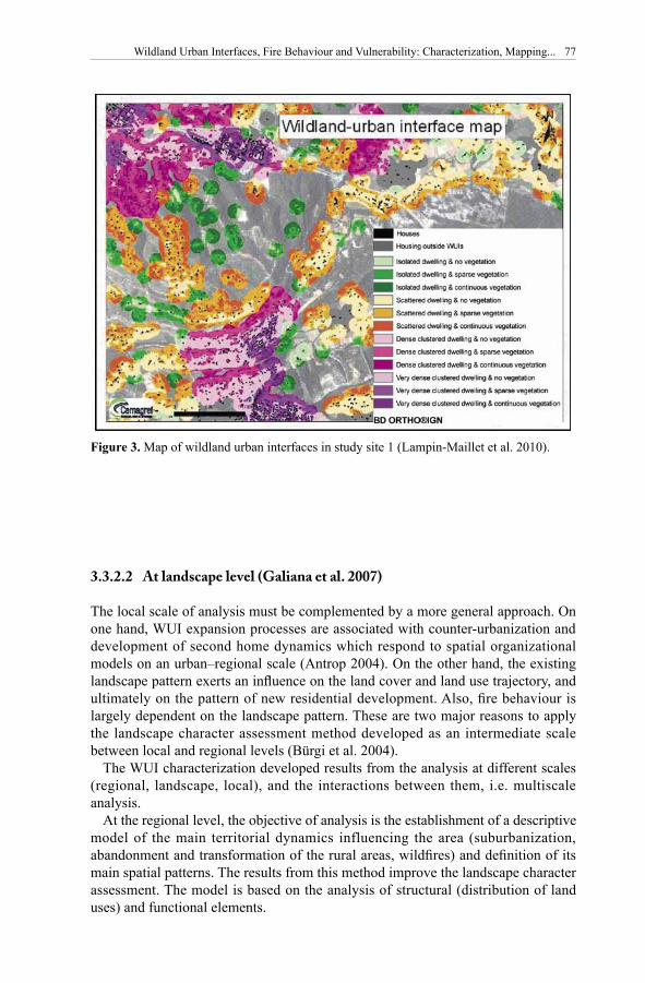
The third step is combining the two previous criteria through a geographical information system (GIS). The calculation allowed mapping of the WUIs according to 12 types (Figure 2) by crossing four classes of dwelling types and three classes of vegetation aggregation indices in a raster format. The WUI method has been applied in different areas in France and Spain. Figure 3 is an illustration of the WUI map carried out on French site, site 1 of Figure 1.
Figure 2. Typology of wildland urban interfaces (Lampin-Maillet et al. 2010).
Wildland Urban Interfaces, Fire Behaviour and Vulnerability: Characterization, Mapping... 77
3.3.2.2 At landscape level (Galiana et al. 2007)
The local scale of analysis must be complemented by a more general approach. On one hand, WUI expansion processes are associated with counter-urbanization and development of second home dynamics which respond to spatial organizational models on an urban–regional scale (Antrop 2004). On the other hand, the existing landscape pattern exerts an influence on the land cover and land use trajectory, and ultimately on the pattern of new residential development. Also, fire behaviour is largely dependent on the landscape pattern. These are two major reasons to apply the landscape character assessment method developed as an intermediate scale between local and regional levels (Bürgi et al. 2004).
The WUI characterization developed results from the analysis at different scales (regional, landscape, local), and the interactions between them, i.e. multiscale analysis.
At the regional level, the objective of analysis is the establishment of a descriptive model of the main territorial dynamics influencing the area (suburbanization, abandonment and transformation of the rural areas, wildfires) and definition of its main spatial patterns. The results from this method improve the landscape character assessment. The model is based on the analysis of structural (distribution of land uses) and functional elements.
Figure 3. Map of wildland urban interfaces in study site 1 (Lampin-Maillet et al. 2010).
78 Towards Integrated Fire Management
At the landscape level, the multiscale analysis consists in the Landscape Character Assessment (LCA), based on the natural and cultural features present in the landscape and on evaluation of functional dynamics and uses. Landscape description established a hierarchical typology composed of two levels: landscape units and types (Countryside Agency and Scottish Natural Heritage 2002). The LCA provides the territorial context of the WUI studied in order to correlate urbanization processes with the type of landscape in which they occur and with the foreseeable risk evolution in these areas.
At the local scale, the WUI characterization process consisted of identifying the different morphologies defined by urbanization processes, examining them in the context of the landscape type of the area in which they occur and characterizing them according to fire behaviour.
Figure 4 is an illustration of the WUI map at landscape level located in site 2 of Figure 1.
3.3.3 Fire hazard assessment in WUIs (Lampin et al. 2009)
3.3.3.1 Steps for fire hazard mapping
The work presented hereafter is aiming at the definition of a standard workflow for obtaining a fire hazard map that will take into account structural and dynamic factors within a GIS. The map can be updated on a daily basis.
Table 2. WUI characterization. Relation matrix from the combination between the morphology of the settlements and the type of landscape (Specific case: Sierra Calderona)
Type of landscape/ Towns Urbanizations Scattered ruralMorphology of settlementssettlements
I, Western flat topped I, Compact III, Spontaneous IX, Scatteredpeaks towns urbanizations (not planned) settlements on on wildland terrain terraced slopesIII, Wildland mountain II, Compact IV, Urbanizations planned X, Scatteredwith lower bunter towns with on wildland terrain settlements onsandstones and extensions wildland terraincultivated gullies
IV, Agroforestal slopes V, Spontaneous XI, Scattered - urbanizations (not planned) settlements onV, Small agricultural VI, Urbanizations planned cultivated slopesvalleys on wildland terrain
Wildland Urban Interfaces, Fire Behaviour and Vulnerability: Characterization, Mapping... 79
Calculation of a structural index (Probability of occurrence) There are several approaches attempting to assess the combined impact of structural factors on fire hazard. Factors that are usually taken into account usually are:
- Human presence (population, distance from settlements, distance from roads etc.);
Factors are integrated into equations, each one weighted according to the author’s opinion on its relative importance, to produce hazard indices. To overcome the subjectivity in weighting of the contributing factors, new techniques have been elaborated like principal component analysis (Xu et al. 2006), logistic regression (Chou and Minnich1993, Martinez et al. 2009) and neural networks (Vasilakos et al. 2007). These techniques seek to establish a relationship between those factors and fire history. Among those new techniques, logistic regression has been extensively used as it provides a probability of occurrence as an output. The accuracy of the assessment can be easily estimated by the observed fire incidents.
In a first step, a group of potentially significant variables for the prediction of fire occurrence must be defined (for example: fuel types, elevation, aspect, distance from nearest road, average annual rainfall, etc.). These variables should be regressed against a data set containing the perimeters of historic fire incidents.
In a second step, an exploratory analysis (e.g. Chi2 significance test) should be performed, in order to identify if any of the variables in consideration are not related to fire occurrence. Further, weights are assigned to each of the remaining variables
Figure 4. WUI map at landscape level in Spanish study site, site 2.
80 Towards Integrated Fire Management
according to its significance, which is calculated by means of logistic regression. The logistic model of fire occurrence probability can be expressed as:
PFOi = (1)
Where PFOi is the probability of a fire to occur in the ith geographic unit (pixel) and Zi can be calculated as:
Zi = b0 + b1X1i + b2X2i + ... + bjXji + e (2)
Where Xji is the value of the jth variable in consideration in the ith geographic unit (pixel or polygon), bj is the weight of the jth variable and e is an error term.
As implied by equation 1, when Zi approaches positive infinity, the value of the index approaches 1, indicating that the ith geographic unit is definitely going to burn in the next period. Similarly, when Zi approaches negative infinity, the value of the index approaches 0, indicating that the ith geographic unit is not going to burn.
Value range for the PFO: PFO, being a probability, ranging between 0 and 1.
Calculation of a daily (dynamic) index Considering the short-term component, different strategies have been applied. Most of them consist of trying to assess the effect of fuel water content on fuel flammability. The Canadian Fire Weather Index (FWI) is generally considered as one of the most efficient in defining the daily risk, as it has been globally applied and evaluated in very diverse ecosystems besides Canada (Marzano et al. 2004, Viegas et al. 1994). For these reasons the FWI is the dynamic index proposed also here. A schematic presentation of the FWI structure is shown in Figure 5.
The values of the required variables for the calculation of the FWI (temperature, relative humidity, wind and rainfall) are usually derived from meteorological stations or sensors. In order to calculate an FWI surface (map), there is a need to obtain a surface of values for each one of the above-mentioned variables. Thus, the point source values of those variables have to be interpolated, before the final calculation of the FWI (Mantzavelas et al. 2007).
Value ranges for the FWI: FWI is open-ended with ranges from 0 to 100+. Values from 0 to 8 are considered as low values, values from 8 to 17 are considered as moderate values, values from 17 to 32 are considered as high values, and values greater than 32 are considered as extreme values (Raínha and Fernandes 2002, Alexander 2008).
Combination of structural and daily indices; the Composite Index (CI)As discussed above, the structural index PFO is calculated by considering all factors (human, topography, vegetation, weather, etc.) that contribute to the occurrence of the wildfire phenomenon. But, as implied by the calculation method, the structural index is a long-term predictor of fire occurrence and can only be considered as an average probability, because it does not take into account the current status of fuel, which is thought to be a very significant factor in the occurrence of wildfires. For instance, a heavy rain incident can reduce the chance of fire to zero, even in a place where the (long-term) occurrence probability is thought to be high. On the other hand, a meteorological index like the FWI, represents the ignition risk that
Wildland Urban Interfaces, Fire Behaviour and Vulnerability: Characterization, Mapping... 81
is contributed upon the daily fluctuations of the weather and their impact on fuel moisture status. Although the FWI is considered as quite efficient in defining the daily ignition risk, it is reasonable to think that: (a) all ignitions cannot be explained by a low fuel moisture level; and (b) not all ignitions develop into fires (e.g. in the case of a lack of fuel).
Thus, it becomes apparent, that an integrated approach is needed, in order to better understand and define the wildfire hazard issue. We propose, for that reason, the calculation of a Composite Index (CI), which is the product of the Structural Index (PFO) and the Fire Weather Index (FWI), such as:
CIi = PFOi * FWIi (3)
where: CIi is the value of the Composite Index for the ith geographic unit, PFOi is the value of the Structural Index for the ith geographic unit, and FWIi is the value of the FWI for the ith geographic unit.
The CI can be considered as the ‘valid’ portion of the FWI calculation. That is, provided that the calculation of the probability of fire occurrence in PFO is correct, then the CI is the part of the FWI value that remains meaningful under the combined influence of structural factors and fire history. In other words, we may say that CI is the part of the FWI value that is validated by structural factors and fire history (if the PFO value is 0 then the CI value becomes 0, whereas if the PFO value is 1 then the CI value is 100% of the FWI value).
Value ranges for the CI: CI, being the product of the PFO and the FWI has the same value range as the FWI (0 to 100+).
The Potential Fireline Intensity (PFI)Until now, we have only dealt with the issue of fire occurrence. In order to have a broader view on the issue of fire hazard, we have to explore the possible
Figure 5. Simplified structure diagram for the Fire Weather Index (after Van Wagner 1987).
Fire Weather Observations
TemperatureRelative Humidity
WindRain
TemperatureRelative Humidity
Rain
TemperatureRain
Fire Behaviour Indexes
Fuel Moisture Codes
Initial Spread Index
Fire Weather Index
Build Up Index
Wind
DroughtCode
Duff Moisture Code
Fine Fuel Moisture Code
82 Towards Integrated Fire Management
consequences from a certain fire incident (Alexander 2008). A way to do so is to calculate the potential fireline intensity, which is the potential energy release per unit length of the fire front in the case of a fire incident. The calculation of fireline intensity is significant in fire suppression and the study of the ecological effects of fire. The fireline intensity is calculated as a function of fuel mass, the rate of spread and a ‘constant’ number, usually taken to be equal to 18 000 kJ/kg (Byram 1959):
PFIi = 18 000 * Wi * ROSi (4)Where: PFLi is the fireline intensity for the ith geographic unit (kW/m),
Wi is the available fuel mass in the ith geographic unit (kg/m2), and ROSi is rate of fire spread in the ith geographic unit (m/sec).
Provided that fuel types are mapped according to the classification scheme introduced by Anderson (1982), or another classification scheme resulting in the description of fuel, mean values for Wi and ROSi are normally incorporated in the description of fuel types.
Value ranges for the PFI: PFI values range between 0 and 100 000 kW/m. Intensity values from 0 to 350 kW/m are considered as the low values, from 350 to 1700 kW/m are considered as moderate values, from 1700 to 3500 kW/m are considered as high values, from 3500 to 7000 kW/m are considered as very high values, and values greater than 7000 kW/m are considered as extreme values (Lampin et al. 2002).
3.3.3.2 The Hazard Index (HI) building and mapping
Finally the Hazard Index (HI) can be seen as a combination between the Composite Index and the Potential Fire Intensity. We propose the relationship defined in Table 2 for the calculation of HI.
The idea that stands behind the HI calculation is to integrate into one single index, the issues of fire ignition, fire spread, and the potential to cause damage. The HI embodies the different aspects of the indices that this index is calculated from. On the one hand, the CI indicates the effects of current weather conditions and fire history upon fire occurrence, while the PFI indicates the severity of the fire should an ignition occur.
For example, if current weather conditions do not favor ignition or spread and this is also validated by the fire history (‘Low’ CI value), and the potential fireline intensity is low (‘Low’ PFI value), then we should expect a low intensity fire, or
Table 3. Calculation of the Hazard Index.
CI\PFI Low Moderate High Very high Extreme
Low Low Low Moderate Moderate HighModerate Low Moderate Moderate High Very highHigh Moderate Moderate High Very high ExtremeExtreme Moderate High Very high Extreme Extreme
Wildland Urban Interfaces, Fire Behaviour and Vulnerability: Characterization, Mapping... 83
no fire at all (‘Low’ HI value). If current weather and fire history indicate that fire occurrence is very likely (‘Extreme’ CI value), and the potential fireline intensity is ‘Extreme’, then we should expect a very intense fire that may cause extensive damage (‘Extreme’ HI value). Intermediate classes of the HI (‘Moderate’, ‘High’ and ‘Very High’) can be explained, similarly, as the kind of fire behaviour and intensity that is expected at a given place and time. Figure 6 illustrates the map of this HI.
3.3.4 Vulnerability assessment in WUIs
The main objective is to develop a set of processes for mapping a synthetic index of the WUIs vulnerability to forest fires. Vulnerability assessment comes from its threefold consideration (a consequence, a state or characteristic, and a cause) as it is considered in the different definitions used above. In consequence vulnerability is formed by an internal component, related to the effects of the fire caused on the value of the affected goods and its capacity for recovery, and by an external component, related to the fire characteristics and by the ability developed by society to face the danger of wildfire.
Based on this approach, a wide variety of factors influencing vulnerability of the territory to forest fires have been identified and methods to obtain parameters
Figure 6. Example of calculation of the HI in the Greek study site 3 for 14/04/2007.
84 Towards Integrated Fire Management
and its cartography at local level for the calculation of these factors have been proposed (Figure 7). Each factor will be further subcategorized into parameters. These parameters are the basic units that have to be mapped and standardized into a common, simple quantitative scale in order to allow them to be aggregated through a process based on multicriteria evaluation, where each variable is given a particular weight. The aggregation process can be repeated until all the hierarchical structure is aggregated into one single indicator, the vulnerability index and it will show whether a particular area is susceptible to suffer damage from wildfire. When all the components are calculated, the vulnerability index can be determined and will show whether a particular area is susceptible to suffer damage from wildfire.
In the task of obtaining these parameters, the modelling of potential high risk situations and the historical analysis of wildfires have played a very important role; also the conclusions obtained from the tasks of WUI characterization have been
Figure 7. Flow chart illustrating the elements involved in assessing vulnerability index.
Wildland Urban Interfaces, Fire Behaviour and Vulnerability: Characterization, Mapping... 85
incorporated. Finally, the factors have been grouped into four synthetic components (difficulty of extinction, demand for forest defense, demand of civil protection and territorial value) which are integrated into a global index. Consultations with forest management and fire fighting experts of the experimental area (Sierra Calderona, Valencia, España) by applying a DELPHI methodology have been fundamental for the determining the weights given to the factors that make up each of the indices.
The final index which can be mapped (Figure 8) and the intermediate components, factors and parameters, are useful for the managers of territorial planning, emergencies and forest fire prevention and fighting.
3.3.5 A specific approach of fire risk assessment in WUIs through a total risk index (Lampin-Maillet 2009)
The work presented hereafter is aiming at the definition of a process for obtaining a fire risk map through the calculation of a total fire risk index based on a WUI map. The map can be updated on a basis depending on the territory WUI extension.
Considering the WUI map, a new perception of the territory is possible: WUI area, and outside WUI area. Because of their high vulnerability, ignition probability and combustibility, it is important and efficient to focus risk assessment in the WUIs. The method developed allows assessment and mapping of fire risk levels.
Figure 8. Map of vulnerability levels on Spanish study site (site 2 in Figure 1).
86 Towards Integrated Fire Management
A spatial analysis on the studied territory was performed in order to establish relationships between the distribution of fire ignition points and burned areas and different land cover data, WUI types, environmental data. For that, a digitalized database of fire ignition points created by the French National Forest Institute (ONF) was used. It comprised fire ignition points during the 1997–2007 period for which the fire area was more than one hectare. Around 565 fire ignition points were located in the study area. A digitalized database of burned area produced by the Administration of Agriculture and Forest of Bouches-du-Rhône was used. It comprised 109 wildfires recorded study area during the 1990–2007 period. At last, a thematic land cover layer obtained from the Spot Thema database elaborated in 2004 by CNES, Provence-Alpes-Côte-d’Azur Region and a Spot Image from Spot 5 satellite imagery on the study area were used. The detailed level describes the territory (urban, agricultural and natural components) at the 1:10 000 scale.
As a result of the relationships established between WUIs and fire indicators calculated with past fire data (fire ignition density and burned area ratio), it is possible to identify specific WUIs which present a high level of fire risk. Figure 9 shows that WUIs corresponding to isolated dwellings present a high level of fire risk due to high levels of ignition density and burned area ratio. WUIs corresponding to very dense clustered dwellings present also a high level of ignition density linked with human activities but a low burned area ratio (high urban component and low vegetation component) (Lampin-Maillet et al. 2010).
The spatial analysis also allowed identification of a set of conditions that correspond with high fire risk in WUIs: housing density, road density, vegetation more or less continuous. Results of this analysis are expressed through three main functions (or fire risk indicators) based on statistical multiple regressions with R2 more or less high:
- Fire Ignition Density FID = Exponential function (territory type, land cover type, housing density) with R2 = 51%;
- Wildfire Density WD = Exponential function (territory type, land cover type, housing density, coniferous forests, exposure to very warm temperatures) with R2 = 57%;
- Burned Area Ratio BAR = Polynomial function (territory type, land cover type, housing density, road density, country road density, garrigues, altitude, low aggregation of vegetation) with R2 = 36%.
A total index of wildfire risk was developed combining the three previous indicators (Lampin-Maillet 2009). In reference to fire risk definition, each of the three indicators includes information about hazard and/or vulnerability: Fire Ignition Density FID and Wildfire Density WD are particularly concerned by fire occurrence (ignition probability and wildfire probability) and Burned Area Ratio BAR is related to hazard and vulnerability through the intensity element. Their combination can contribute to a pertinent and efficient assessment of fire risk. So a Fire risk total index RI has been built corresponding to a linear combination of the three indicators having the same weight but corrected by their explanation level (R2 value). In the case of the study area the equation is:
Fire risk total index RI = 0.89 FID + WD + 0.63 BAR
Wildland Urban Interfaces, Fire Behaviour and Vulnerability: Characterization, Mapping... 87
Figure 9. Fire ignition density and burned area ratio according to WUI types in Lampin-Maillet (2009).
Figure 10. Map of wildfire risk global index in WUIs in the French study site (site 1 in Figure 1).
88 Towards Integrated Fire Management
With respectively a correction of 0.89 corresponding to the ratio 51% / 57% for FID, a value of 1 (the best R2 value) corresponding to the ratio 57% / 57% for WD, and a correction of 0.63 corresponding to the ratio 36% / 57% for BAR.
A map of this fire risk total index can be produced as illustrated at Figure 10 in the South of France.
Certain types of WUIs represent a high level of fire risk in terms of fire ignition density, wildfire density and burned area ratio. Regarding fire ignition density and burned area ratio, isolated WUIs with low and high aggregation indices of vegetation presented the highest values. Scattered WUIs with both low and high aggregation indices of vegetation also represented a high level of fire ignition density and burned area ratio even if these values were lower than those for isolated WUIs (Lampin-Maillet et al. 2010). Results also highlighted the fact that the burned area ratio generally decreased from isolated WUIs to dense and very dense clustered WUIs, and also decreased from a high aggregation index to a zero aggregation index (Lampin-Maillet et al. 2010).
3.3.6 Conclusions
In this chapter we proposed reproducible methods for characterizing and mapping WUIs at large scales and over large areas (Lampin-Maillet et al. 2010) and at landscape scale (Galiana et al. 2007). We also proposed on the one hand a method for fire hazard assessment and mapping (Lampin et al. 2009), and on the other hand a method for vulnerability assessment and mapping (Galiana et al. 2009). These two processes contribute to assessment of fire risk, combining fire hazard and vulnerability assessments. A specific approach has also been developed to calculate and to assess a total index of wildfire risk in WUIs (Lampin-Maillet 2009).
The WUI is often a location which is particularly appreciated as an area in which to live. However, in our European Mediterranean context this lifestyle carries a certain risk: people should always be aware of the existing fire risk in such WUI and should respect and apply efficient recommendations to insure against risky situations.
These results could have interesting implications for fire prevention and land management. Introducing the risk of wildfire with such maps, and particularly the vulnerability of the territory, is a way to make the inhabitants becoming aware of fire risk in WUIs. The WUI map is key information to identify locations where vegetation has to be reduced in order to protect the houses and their inhabitants in case of wildfire and where careful behaviour are essential to avoid fire ignition. This will globally decrease the risk of fire either by reducing fire propagation through biomass removal and/or by reducing fire ignition probability together with less carelessness. Accomplishing this goal is strictly related to the designation of suitable prevention messages and preventive actions which can be different according to WUI types.
WUIs have increased considerably all over the world in recent decades and this trend will certainly continue in the coming years due to the continuing trend of land abandonment combined with urbanization. The method we developed for mapping
Wildland Urban Interfaces, Fire Behaviour and Vulnerability: Characterization, Mapping... 89
WUIs is an appropriate tool for the assessment of WUI dynamics and associated fire risk dynamics in the context of ongoing changes in climate, urbanization and vegetation.
References
Alexander, M.E. 2008. Proposed revision of fire danger class criteria for forest and rural areas in New Zealand. 2nd Ed. National Rural Fire Authority, Wellington, in association with Scion, Rural Fire Research Group, Christchurch. 62 p.
Anderson, H.E. 1982. Aids to determining fuel models for estimating fire behaviour. USDA Forest Service General Technical Report INT-122, Intermountain Research Station, Ogden, UT. 22 p.
Antrop, M. 2004. Landscape change and the urbanization process in Europe. Landscape and urban planning 67: 9–26.
Alavalapati, J.R.R., Carter, D.R. and Newman, D.H. 2005. Wildland-urban interface: Challenges and Opportunities. Forest policy and Economics 7: 705–708.
Byram, G.M. 1959. Combustion of forest fuels. In: Davis K.P. (ed). Forest Fire: Control and Use. McGraw-Hill, New York.
Blaikie, P., Cannon, T., Davis, I. and Wisner, B. 1994. At risk: natural hazards, people vulnerability and disaster. Routledge, London, New York. 280 p.
Blanchi, R., Jappiot, M. and Alexandrian, D. 2002. Forest fire risk assessment and cartography. A methodological approach. In: Viegas, D. (ed.). Proceedings of the IV International Conference on Forest Fire Research. Luso, Portugal.
Brunet, R., Ferras, R. and Théry, H. 1993 (3rd Ed.). Les mots de la géographie. Paris, Montpellier, La documentation française. 518 p.
Bürgi, M., Hersperger, A.M. and Schneeberger, N. 2004. Driving forces of landscape change – current and new directions. Landscape Ecology 19: 857–868.
Caballero, D., Giroud, F., Picard, C. and Xanthopoulos, G. 2004. EUFIRELAB/ Euro-Mediterranean Wildland Fire Laboratory, a "wall-less" laboratory for wildland fire Sciences and technologies in the Euro-Mediterranean Region - Deliverable D-10-01- Wildland-Urban Interface Management: A state of the art. 28 p.
Camia, A., Guglielmet, E., Bovio, G. Deshayes, M., Lampin, C., Salas, J., Martinez, J., Molina, D., Carrega, P., Fox, D., Berolo, W., Sabate, S., Vayreda, J., Martin, P., Martinez, J., Conese, C., Bonova, L., Karteris, M., Mallinis, G., Sergiopoulos, I. and Gitas, I. 2004. Eufirelab: Euro-Mediterranean Wildland Fire Laboratory, a "wall-less" laboratory for wildland fire Sciences and technologies in the Euro-Mediterranean Region Deliverable D 08-02: Wildland fire danger and hazards: a state of the art. 57 p.
Carroue, L., Claval, P., Di Meo, G., Miossec, A., Renard, J.P., Simon, L. and Veyret, Y. 2002. Limites et discontinuité en géographie. Dossiers des images économiques du monde, Edition SEDES. 159 p.
Chen, K., Blond, R. and Jacobson, C. 2003. Towards an integrated Approach to natural Hazards risk assessment using GIS: with reference to bushfires. Environmental Management 31 (4): 546–560.
Chou, Y.H. and Minnich, R.A. 1993. Mapping Probability of Fire Occurrence in San Jacinto Mountains, California, USA. Environmental Management 17(1): 129–140.
Coburn, A.W., Spence, R.J.S. and Pmomonis, A. 1994. Vulnerability and risk assessment. Disaster management training Program, UNDP/DHA, 70 p.
90 Towards Integrated Fire Management
Colin, P.Y., Lampin, C., Delboube, E., Coste, N., Marcillat, J., Pereira, J.C., Binggeli, F., Gaulier, A. ,Botelho, H., Loureiro, C., Loddo, G., Ditana, E., Guijarro, M., Hernando, C., Diez, C., Martinez, E., Madrigal, J., Vega, J.A., Gorostiaga, P., Alexandrian, D. and Dimitrakopoulos, A. 2002. SALTUS - Spot fires : mechanisms analysis and modelling - Final report 1998, ENV98-CT98-0701.
Countryside Agency and Scottish Natural Heritage, 2002. Landscape Character Assessment: guidance for England and Scotland (Wetherby, Countryside Agency and Scottish Natural Heritage).
Davis, J. B. 1990. The wildland-urban interface: paradise or battleground? Journal of Forestry 88(1): 26–31.
D’Ercole, R. 1998. Approches de la vulnérabilité et perspectives pour une meilleure logique de réduction du risque. Pangea 29(39): 20-28.
D’Ercole, R. 1996. Représentation cartographiques des facteurs de vulnérabilité des populations exposées à une menace volcanique. Application à la région du volcan Cotopaxi (Equateur). Bulletin de l’IFEA 25(3): 479–507.
Galiana, L., Herrero, G. and Solana, J. 2007. Caracterización y clasificación de Interfaces Urbano-Forestales mediante análisis paisajístico. El ejemplo de Sierra Calderona (Comunidad Valenciana, España). Book of Abstracts of the IV International Wildland Fire Conference, Seville, Spain. Organismo Autónomo de Parques Nacionales, Ministerio de Medio Ambiente. 285 p.
Gallopin, G.C. 2006. Linkages between vulnerabilty, resilience and adaptative capacity. Global Environmental Change 16: 293–303.
Hardy, C.C. 2005. Wildland fire hazard and risk: Problems, definitions, and context. Forest Ecology and Management 211: 73–82.
Jappiot, M., Gonzalez-Olabarria, J.R., Lampin-Maillet, C. and Borgniet, L. 2009. Assessing Wildfire Risk in Time and Space. Partie de Living with Wildfires: What science can tell us. Yves Birot (ed.) EFI Discussion Paper 15. European Forest Institute. Joensuu. Pp. 41–47.
Johnson, M. P. 2001. Environmental impacts of urban sprawl: a survey of the literature and proposed research agenda. Environment and Planning A 33: 717–735.
Lampin-Maillet, C. 2009. Caractérisation de la relation entre organisation spatiale d’un territoire et risque d’incendie : le cas des interfaces habitat-forêt du sud de la France. Thèse de doctorat de l’Université de Provence, Aix-Marseille I. 321 p.
Lampin-Maillet, C., Jappiot, M., Long, M., Morge, D. and Ferrier, J.P. 2010. Mapping wildland-urban interfaces at large scales integrating housing density and vegetation aggregation for fire prevention in the South of France. Journal of Environmental Management 91 (2010):732–741.
Lampin-Maillet, C., Jappiot, M., Long, M., Morge, D. and Ferrier, J.P. 2009. Characterization and mapping of dwelling types for forest fire prevention. Computers, Environment and urban systems 33(2009): 224–232.
Lampin-Maillet, C. 2008. 2007, Summer Fires in the European Mediterranean – The Cases of Greece, Italy and Spain. Mediterranean yearbook. European Institute of the Mediterranean. Med. 2008, Economy and Territory- Sustainable Development. Pp 243–247.
Lampin, C., Jappiot, M., Long M., Morge, D., Bouillon, C., Galiana, L., Herrero, G., Solana, J., Mantzavilas, A., Loddo, G. and Delogu G. 2007a. Characterization and mapping of wildland-urban interfaces: a methodology applied in the study case in Sardinia. Book of Abstracts of the IV International Wildland Fire Conference, Seville, Spain. Organismo Autónomo de Parques Nacionales, Ministerio de Medio Ambiente. 289 p.
Lampin, C., Long, M., Jappiot, M., Morge, D., Bouillon, C., Mantzavellas, A., Apostolopoulou, I., Lazaridou, T., Partozis, T., Topaloudis, T., Galiana, L., Herrero, G., Solana, J., Loddo, G., Brigaglia, S., Dettori, G. and Delogu, G. 2007b. Method to characterize and to map wildland urban interfaces. Deliverable D5.2-1 of the Integrated Project “Fire Paradox”, Project no. FP6-018505. European Commission. 104 p.
Wildland Urban Interfaces, Fire Behaviour and Vulnerability: Characterization, Mapping... 91
Lampin, C., Long, M., Jappiot, M., Morge, D., Bouillon, C., Mantzavelas, A., Apostolopoulou, I., Lazaridou, T., Partozis, T., Topaloudis, T., Galiana, L., Herrero, G. and Solana, J.L. 2007c. Guide for end-users to characterize and to map wildland-urban interfaces. Deliverable D5.2-2 of the Integrated Project “Fire Paradox”, Project no. FP6-018505, European Commission. 18 p.
Lampin, C., Jappiot, M., Long, M. and Borgniet, L. 2006. Cartographie des interfaces habitat-forêt. Une approche spatiale pour estimer le risque d’incendie de forêt, Revue internationale de Géomatique. European journal of GIS and Spatial analysis, Information géographique et gestion des risques l16(3–4): 320–340.
Lampin, C., Jappiot, M., Alibert, N., Manlay, R. and Guillande, R. 2002. Prototype of an Intensity Scale for the Natural Hazards: Forest Fire. In Viegas, D. (ed.). Proceedings of the IV International Conference on Forest Fire Research. Luso, Portugal.
Macie, E.A. and Hermansen, L.A (eds). 2002. Human influences on Forest Ecosystems: The Southern Wildland-Urban lnterface Assessment.
McGarigal, K. 2002. Landscape Pattern Metrics. Chapitre du livre Encyclopedia of Environmentrics, Volume 2. John Wiley & Sons, Sussex, England.
Lampin, C., Mantzavelas, A., Apostolopoulou, I., Lazaridou, T., Partozis, T. and Topaloudis, T. 2009. Adapted method to assess and map fire hazard in wildland urban interfaces. Internal Report IR5.1-4 of the Integrated Project “Fire Paradox”, Project no. FP6-018505. European Commission. 19 p.
Mantzavelas, A., Apostolopoulou, I., Lazaridou, T., Partozis, T., Lampin, C., Long, M. and Jappiot, M. 2008. Literature review and synopsis of the methodologies to estimate vulnerability. Deliverable D5.2-5 of the Integrated Project “Fire Paradox”, Project no. FP6-018505. European Commission. 13p.
Mantzavelas, A., Apostolopoulou, I., Lazaridou, T., Partozis, T., Topaloudis, T., Lampin, C., Borgniet, L., Bouillon, C., Brewer, S., Curt, T., Ganteaume, A., Jappiot, M., Defossé, G., Gómez Fernán, M. and Lencinas Daniel, J. 2009. Method to assess with good spatial accuracy the meteorological and fuel moisture components of the fire risk. Deliverable D5.1-1 of the Integrated Project “Fire Paradox”, Project no. FP6-018505. European Commission. 89 p.
Martinez, J., Vega-Garcia, C. and Chuvieco, E. 2009. Human-caused wildfire risk rating for prevention planning in Spain. Journal of Environmental Management 90(2): 1241–1252.
Marzano, R., Bovio, G., Guglielmet, E., Jappiot, M., Lampin, C., Dauriac, F., Deshayes, M., Salas, J., Aguado, I., Martinez, J., Molina, D., Martinez, E., Carrega, P., Fox, D., Berolo, W., Martin, P., Gomez, I., Conese, C., Bonora, L., Karteris, M., Gitas, I., Mallinis, G. and Giannakopoulos, V. 2004. Common methods for mapping the wildland fire danger, EUFIRELAB, Deliverable D-08-05.
McGee, T. K. 2005. Completion of recommended WUI fire mitigation measures within urban households in Edmonton, Canada. Environmental Hazards 6: 147–157.
Radeloff, V.C., Hammer R.B., Stewart, S.I., Fried, J.F., Holcomb, S.S. and McKeefry, J.F. 2005a. The wildland urban interface in the United States. Ecological applications 15(3): 799–805.
Radeloff, V.C., Hammer R.B. and Stewart, S.I. 2005b. Rural and suburban sprawl in the U.S. Midwest from 1940 to 2000 and its relations to forest fragmentation. Conserv. Biol. 19(3): 793–805.
Rainha, M. and Fernandes, P.M. 2002. Using the Canadian Fire Weather Index (FWI) in the Natural Park of Montesinho, NE Portugal: calibration and application to fire management. In Viegas, D. (ed.). Proceedings of the IV International Conference on Forest Fire Research. Luso, Portugal.
San Miguel-Ayanz, J., Carlson, J.D., Alexander, M., Tolhurst, K., Morgan, G., Sneeuwjagt, R. and Dudley, M. 2003. Current Methods to Assess Fire Hazard Potential. In: Chuvieco, E. (ed.). Wildland Fire Hazard Estimation and Mapping. The Role of Remote Sensing Data. World Scientific Publishing, Singapore. Pp. 21–61.
92 Towards Integrated Fire Management
Stewart, S.I., Radeloff, V.C. and Hammer, R.B. 2003. Characteristics and location of the Wildland-Urban-Interface in the United States. p. 6. Proceedings of the 2nd International Wildland Fire Ecology and Fire Management Workshop, November 16–20, 2003, Orlando, Florida.
USDA-USDI. 2001. Urban wildland interface communities within vicinity of Federal lands that are at high risk from wildfire. U.S. Department of Agriculture and U.S. Department of Interior, Fed.Reg. 66: 751–777.
Van Wagner, C. E. 1987. Development and Structure of the Canadian Forest Fire Weather Index System. Can. For. Serv., Ottawa. For. Tech. Rep. 35. 37 p.
Vasilakos, C., Kalabokidis, K., Hatzopoulos, J., Kallos, G. and Matsinos, Y. 2007. Integrating new methods and tools in fire danger rating. International Journal of Wildland Fire 16: 306–316.
Viegas, D.X., Sol, B., Bovio, G., Nosenzo, A. and Ferreira, A. 1994. Comparative study of various methods of fire danger evaluation in Southern Europe. In: Viegas, D. (ed.). Proceedings of II International Conference on Forest fire Research. Coimbra, Portugal. Pp. 571–590.
Vince, S.W., Duryea, M.L., Macie, E.A. and Hermansen, L.A. (eds.) 2005. Forests at the wildland-urban interface: conservation and management. CRC Press, Boca Raton.
Wilson, K., Pressey, R.L., Newton, A., Burgman, M., Possingham, H. and Weston, C. 2005. Measuring and incorporating vulnerability into conservation planning. Environmental Management 35(5): 527–543.
Xu, D., Guofan, S., Dai, L., Hao, Z., Tang, L. and Wang, H. 2006. Mapping forest fires risk zones with spatial data and principal components analysis. Science in China: Series E Technological Sciences 49(I): 140–149.
3.4 The Importance of Economics in Fire Management Programmes Analysis
Robert Mavsar1, Armando González Cabán2 and Verónica Farreras1 1Forest Technology Centre of Catalonia, Barcelona, Spain2USDA Forest Service, Pacific Southwest Research Station, Riverside (CA), USA
3.4.1 Introduction
Wildfires are a societal problem that threatens many ecosystems, affects millions of people worldwide, and causes major ecosystem and economic impacts at local regional, national and global scales. In Europe, and especially in the Mediterranean countries (France, Greece, Italy, Portugal and Spain), wildfires continue to be a major environmental threat (Requardt et al. 2007) where, an average 500 000 ha of forests are burned annually (San-Miguel and Camia 2009). Wildfires affect the forests and other wooded land, and neighbouring systems such as urban areas, infrastructure networks (i.e. power-lines and transportation corridors), agriculture lands, and the civil society. These impacts can be reflected in many ways – for example, loss of human life or health, decreased well-being of the population (local and wider), and temporary or permanent loss of employment possibilities and economic activities. For a worldwide perspective on the effects of fire on the earth systems see Bowman et al. 2009.
The last decades have seen increased social awareness and growing concerns for wildfires’ negative environmental and economic consequences, and, particularly, the loss of human lives (McCaffrey 2008). The growing importance of wildfire issues at EU level is also reflected in the increasing number of research projects funded to better understand and address this problem (e.g. Eufirelab, Fire Paradox).
In Europe, this change was galvanized by the large-scale wildfires and their consequences in the Mediterranean region during the 2000s. For example, during 2003 in Portugal about 400 000 ha of forests lands were burned; during 2005 in Spain some 190 000 ha of forests lands were damaged; and during 2007 in Greece around 270 000 ha of forests and other wooded lands were destroyed (JRC 2007). Events in other parts of the world also helped to increase the concern on this topic in Europe. These included, Indonesia 1997/1998, where 8 million ha burned; Australia 2007, more than 1 million ha; and California, USA 2007, 120 000 ha affected. These major wildfire events clearly showed that they are not only an environmental problem, but have also a significant social dimension, affecting millions of people, having major economic impacts, and causing significant human casualties (González-Cabán 2007). For example, the wildfires affecting vast forest areas of Portugal in 2005 caused economic damage worth almost €800 million and caused 13 fatalities. Even worse, the large fires affecting Greece during the summer of 2007 caused 64 casualties, and according to the Greek authorities the economic
228 Towards Integrated Fire Management
Narayan, C., Fernandes, P.M., van Brusselen, J. and Schuck, A. 2007. Potential for CO2 emissions mitigation in Europe through prescribed burning in the context of the Kyoto protocol. Forest Ecology and Management 251:164–173.
Orabona, V., Mazzoleni, S. and Giannino, F. 2007. Report on the type of data collection. Deliverable D6.4-1 of the Integrated Project “Fire Paradox”, Project no. FP6-018505. European Commission. 12 p.
Rein, G., Torero, J., Guijarro, M., Esko, M. and Castro, A. 2008. Methods for the experimental study and recommendations for the modelling of pyrolysis and combustion of forest fuels. Deliverable D2.1-1 of the Integrated Project “Fire Paradox”, Project no. FP6-018505. European Commission. 83 p.
Sagarzazu, M.S. and Defossé, G.E. 2009. Study of a 2º set of largest past fires. Deliverable D8.3-1 of the Integrated Project “Fire Paradox”, Project no. FP6-018505. European Commission. 82 p.
Sikanen, T. 2009. Fire safety analysis around targets using FDS: Final achievements - Transport of firebrands and attack on buildings. Deliverable D2.5-4 of the Integrated Project “Fire Paradox”, Project no. FP6-018505. European Commission. 24 p.
Todone, J.F., Bianchi, L.O. and Defossé, G.E. 2009. First field sampling results of dead and live fuel moisture prediction in Patagonia. Internal Report IR3.1-7b of the Integrated Project “Fire Paradox”, Project no. FP6-018505. European Commission. 24 p.
Torero, J.L. 2008. Criteria for building material ignition and assessment of burn injuries in wildland fires: model development. Internal Report IR2.5-3 of the Integrated Project “Fire Paradox”, Project no. FP6-018505. European Commission. 58 p.
Important Concepts and Terms
Integrated fire management: A concept for planning and operational systems that include social, economical, cultural and ecological evaluations with the objective of minimizing the damage and maximizing the benefits of fire. These systems include a combination of prevention and suppression strategies and techniques that integrate the use of technical fires and regulate traditional burning.
Fire management: All activities required for the protection of burnable forest and other vegetation values from fire, and the use of fire to meet land management goals and objectives.
Traditional burning (or traditional fire use): The use of fire by rural communities for land and resource management purposes based on traditional know-how.
Appropriate traditional fire use: The use of traditional burning under legal regulations and good practices.
Technical fire: The controlled use of fire carried out by qualified personnel under specific environmental conditions and based on an analysis of fire behaviour. Technical fires are divided into prescribed fires, wildfires within prescription and suppression fires.
Fire within prescription: A prescribed fire or a wildfire that burns within prescription.
Prescribed burning (or prescribed fire): The application of a fire under specified environmental conditions, which allow the fire to be confined to a predetermined area and to attain planned resource management objectives.
Wildfire within prescription: A wildfire that is confined to a predetermined area and produces the fire behaviour and the fire effects required to attain the planned fire treatment and/or resource management objectives.
Wildfire: Any unplanned and uncontrolled vegetation fire which, regardless of the ignition source, may require suppression response or other actions according to agency policy.
Suppression fire: The application of a fire to accelerate or strengthen the suppression of wildfires.