Wind Atlas for South Africa Capacity development and research cooperation through development of wind resource mapping for the Western Cape and areas of Northern and Eastern Cape Project Document October 2008
Transcript
Wind Atlas for South Africa
Capacity development and research cooperation through development of wind resource mapping for the Western Cape and areas of Northern and Eastern Cape
Project Document
October 2008
Table of Contents1 Background and context ................................................................................................ 3
1.4 The Purpose of this Project Description ................................................................... 8 1.5 Project Initiation ........................................................................................................ 9 1.6 Conditions for Risø DTU to enter into a Twinning Agreement ................................. 9
2 Objectives ..................................................................................................................... 10 3 Scope of work ............................................................................................................... 13 4 Methodology and Implementation ................................................................................ 14
5 Project Organisation .................................................................................................... 29 6 Reporting and Financial Management ........................................................................ 30 7 Intellectual Property Rights ........................................................................................... 31 8 Requirements and assumptions ................................................................................... 31 9 Time line ....................................................................................................................... 33 10 Signature page ........................................................................................................... 34
2
1 Background and context
1.1 Project JustificationSouth Africa seeks capacity and skills development for methods and data that would enable the authorities, investors, power sector and industry to investigate and plan for large-scale exploitation of wind power for electricity generation. This requires a methodology for mapping the wind resources on national and regional scales, as well as tools for estimating reliably the annual energy production (AEP) of proposed wind farms all over South Africa. This twinning agreement outlines how a Numerical Wind Atlas for South Africa (WASA) – based on a state-of-the-art approach employing mesoscale modelling, measurements and microscale modelling – will be developed.
The South African National Energy Research Institute (SANERI) was established under a Ministerial Directive in October 2004 as part of the CEF Group of Companies. SANERI became operational through the joint efforts of the Department of Minerals and Energy and Department of Science and Technology. SANERI’s primary mandate is to undertake non-nuclear energy research. Recognizing the limitation of human capacity for large scale research in this area, national government also mandated SANERI to commission, fund and direct non-nuclear research whilst it builds up its internal capacity. SANERI reports to the Department of Science and Technology (DST) and the Department of Minerals and Energy (DME). SANERI’s objectives are to:
• Increase energy research, development and innovation in South Africa• Support government goals of energy security of supply through identifying viable
and sustainable diversified energy supply options• Act as a national energy research information repository • Increase human capacity in energy research• Transform the composition of energy researchers to more adequately represent
the demographic profile of the country in terms of gender and race.
Since becoming fully operational in December 2006, SANERI has, through a competitive bid process, funded over 50 research projects with a total budget of over R80 million, supported over 100 postgraduate students in energy research in universities across the country, established 4 chairs of energy research, established the Hub of Energy Efficiency and demand Side Management (University of Pretoria) and the Hub of Renewable and Sustainable Energy (University of Stellenbosch) with 3 Spokes (Solar Thermal, Solar PV and Wind) at other institutions.
SANERI is a wholly owned subsidiary of the CEF Group and therefore has a close working relationship with the National Energy Efficiency Agency (NEEA) and Energy Development Corporation (EDC) within the group. The EDC and the NEEA are integrally involved in all major clean energy projects in South Africa. EDC has a mandate to invest in commercial and near-commercial renewable energy and energy efficiency projects and has been or is currently involved in all renewable energy projects under development in SA, Landfill Gas Extraction (Cities of Johannesburg, Cape Town,
3
Ekurhuleni, Ethekwini and Tshwane), biofuel project development and wind farm development (Darling Wind Farm). The National Energy Efficiency Agency is also a state-owned entity and is entrusted with promoting and investing in energy efficiency projects that support the target contained in the National Energy Efficiency Strategy of 2005.
SANERI meets its objectives through the following operational programmes:
i. Human capital development programmes e.g. SANERI bursaries, Chair of Energy Research projects and the Hubs of energy research.
ii. The flagship research projects: through a competitive bid process, SANERI commissions Energy Research projects that would ensure the diversification of South Africa’s energy mix, reduced green house gas emissions and increased security of supply.
iii. Demonstration: SANERI funds the demonstration of new cleaner energy technologies in partnership with technology developers.
The development of a Wind Atlas would therefore accelerate the investment in Wind energy. This is in line with government’s objectives of reducing green house gases and diversifying our energy supply and also developing human capacity to support the emerging industry. As a custodian of public interest and public funded energy research in the country, SANERI has to ensure that research and development initiatives are not duplicated but rather reinforced. Partnering with other institutions will contribute immensely to this goal.
The Wind Atlas can find applications is at least two areas, namely to assist in the development of large grid connected wind farms and to provide more accurate wind resource data to identify potential off-grid electrification opportunities.
The DME, Eskom and CSIR are jointly funding the development of an off-grid electrification planning tool based on harnessing renewable energy resources. However, this off-grid electrification planning tool is dependent on good quality resource data and inputs. The current South African wind energy resource database is inadequate and a more accurate and reliable wind energy resource database will enhance the value of the off-grid electrification planning tool.
1.2 Project Team Brief The core project team consists of five members; each with their distinctive and important role for the implementation of the skills, capacity and research development objectives of the twinning agreement.
1.2.1 SANERI and the WIND SPOKESANERI is a state-funded energy research company, reporting to the Departments of Minerals and Energy as well as Science and Technology. It has been established as a wholly-owned subsidiary of CEF (Pty) Ltd. SANERI’s focus is on public interest energy
4
R&D and seeks to assist national government in meeting the national goals of 1) economic development (and by implication national competitiveness) and 2) improvement of quality of life of all citizens. SANERI is primarily concerned with the development and funding of applied technology-based research but limited funds are available for more fundamental, basic research. An additional focus is on human capital development and the transformation of the composition of energy researchers to more adequately represent the demographic profile of the country, in terms of gender and race.
The Wind Spoke is part of SANERI’s human capital development program and consists of UCT and University of Stellenbosch. The key objectives of the program is to address key issues regarding current technological trends in small and medium-scale wind energy conversion systems. In particular, it focuses on aerodynamic aspects, wind generator technologies, power electronic converter technologies, fault diagnosis, network integration, wind resource assessment and load modeling. It is envisaged that as the demand for renewable energy grows, so would the commercial viability of the small and medium-scale wind energy systems sector. Thus, by investing in research capacity aimed at solving technical problems related to this sector at this early stage, South African industry will eventually be in a key position to address its energy crisis, environmental issues and fully exploit the global market sector as it matures.
1.2.2 UCT (CSAG) CSAG is a dynamic group of multi-disciplinary scientists with research projects linked to all aspects of the climate system. CSAG is hosted in the Environmental and Geographical Science department at the University of Cape Town. CSAG is currently funded for a number of research projects which cover a range of activities, but generally fall into three primary areas; Global Climate Model (GCM) applications, Global Climate Change, and South African climate processes
1.2.3 CSIR The CSIR is one of the leading scientific and technology research, development and implementation organisations in Africa. Constituted by an Act of Parliament in 1945 as a science council, the CSIR undertakes directed and multidisciplinary research, technological innovation as well as industrial and scientific development to improve the quality of life of the country’s people. The CSIR Built Environment's Coastal Engineering and Port Infrastructure research group, originally established in 1971, provides predictive engineering solutions and decision support for the safe and cost-effective development and operation of ports and coastal sites which include state-of-the-art equipment to collect data (real time as well as stand-alone) on a number of environmental parameters, including wind energy. The CSIR’s shareholder is the South African Parliament, held in proxy by the Minister of Science and Technology.
1.2.4 SAWSThe South African Weather Service (SAWS) is the national weather service of South Africa. Presently SAWS is busy with a reassessment of extreme winds for South Africa, and therefore can play an active role in the application part of this project. The outputs
5
of the mesoscale modelling part of this project can serve as a critical input in the determination of the extreme wind climate of South Africa, through the application of the WAsP Engineering software, developed by Risø DTU.
Apart from the above project, SAWS is the custodian of most climate data in South Africa. Specifically, with the high resolution spatial and temporal observational data, SAWS can play an active part in the validation of mesoscale modelling results with measured data. This part of the study will also rely on the weather and climate knowledge of all WASAPT members, including SAWS.
1.2.5 Risø DTURisø DTU has been active for decades in wind energy assessment area, and has developed the WAsP software, a microscale modelling tool for wind farm energy calculations, and the KAMM/WAsP method, for the calculation of wind resources over large areas.
The KAMM/WAsP system output is compatible with WAsP, which allows mesoscale results to be applied all the way down to the microscale for wind farm energy calculations.
Risø DTU is now beginning to use the WRF mesoscale model in wind energy studies, and this model is seen as a likely successor to the KAMM mesoscale model.
Risø DTU has worked with meteorological sensors and measurements for almost half a century. Risø DTU has designed, developed and manufactured several meteorological sensors and data acquisition systems; noticeably the Risø cup anemometer, which today is considered one of a few industry-standard cup anemometers for wind resource assessment and wind turbine power performance testing and verification. Because of its long history within wind power activities, Risø DTU is well acquainted with the special requirements for accurate and reliable wind measurements posed by the wind industry.
1.3 Other key stakeholders Other key stakeholders include the national and regional environmental and energy authorities, the private sector association, private developers and the funders of the twinning agreement.
1.3.1 DMEThe Department of Minerals and Energy (DME) is the national department responsible for energy policy and strategy development. The DME is the Executing Agency for SAWEP. The DME Minister commissioned the Darling National Demonstration Wind farm on 24 May 2008.
1.3.2 SAWEP The twinning arrangement is linked closely to the South African Wind Energy Programme (SAWEP), which is funded by the GEF with the Department of Minerals and Energy (DME) as the Executing Agency and the UNDP as the Implementation Agency. SAWEP has, as one of its outcomes, Wind resource assessment, by assisting
6
interested public and private entities with the generation of reliable wind energy data and other necessary information for wind energy development and verifiable indicators: (i) Updated national wind resource map available by the end of project, (ii) hot spots for wind energy development identified and publicly available, and (iii) detailed wind measurement reports available as a result of (private-sector-led) wind measurements at identified hot spots.
1.3.3 DEAT The Department of Environmental Affairs and Tourism is the national department responsible for environmental, sustainable development and tourism policy and strategy development. DEAT is the lead agency for directing and formulating the national climate change response programme and has the responsibility of ensuring that South Africa’s obligations in terms of the UNFCCC and the IPCC are fulfilled.
1.3.4 DST The Department of Science and Technology (DST) is the national department responsible for science and technology policy, strategy development with a strong emphasis on human capital development. The DST strives toward introducing measures that put science and technology to work to make an impact on growth and development in a sustainable manner in areas that matter to all the people of South Africa. DST together with the Department of Minerals and Energy (DME), have jointly established the South African National Energy Research Institute (SANERI) to address national energy research priorities and capacity building.
1.3.5 Northern, Western and Eastern Cape Provincial Departments The provincial departments responsible for environmental and development planning are in various stages in the development of provincial energy and sustainable development strategies and actions plans. These plans acknowledge the potential wind energy can play in addressing energy and sustainable development issues.
1.3.6 Northern, Western and Eastern Cape MunicipalitiesMunicipalities have a particular role in promoting energy efficiency and sustainable development. Many have incorporated and are supporting energy and sustainable development strategies and applications e.g. City of Cape Town buying green power from the Darling Wind farm with similar activities undergoing in Nelson Mandela Metro etc. Deploying wind measurement masts in suitable Municipal areas are beneficial for Municipalities to get acquainted with wind energy.
1.3.5 SAWEAThe South African Wind Energy Association is an industry led association in support of wind energy industry development in South Africa. SAWEA has a particular role in identifying wind energy development issues, lobby effective support and dissemination of information to its members and the general public.
7
1.3.6 Private DevelopersSouth Africa is experiencing an economic growth while its electricity generation and distribution capacity are ageing and are under pressure. It is acknowledged the role that the private sector can play in alleviating the electricity capacity need in the short and long term. Wind energy has a short lead time and can strengthen distribution networks. This requires accurate resource information that can be used for feasibility studies and motivation of bankable projects.
1.3.7 UNDP
UNDP is the UN's global development network, an organization advocating for change and connecting countries to knowledge, experience and resources to help people build a better life. UNDP is on the ground in 166 countries, working with them on their own solutions to global and national development challenges (climate change etc) UNDP-implemented projects and programmes are primarily managed by the organization's extensive network of over 130 country offices, with the central UNDP GEF environment team providing technical guidance and support. The local UNDP is the Implementation Agency for the SAWEP.
1.3.8 Royal Danish EmbassyThe Royal Danish Embassy works within the development priorities of the South African Government as stated in the South African Government national (Presidential) Programme of Action. In view of the serious energy and climate change challenges to South Africa, Denmark and South Africa has agreed to replace the Danish transitional assistance programme with a long-term development co- operation programme, thus paving the way for a stronger partnership between the two countries. The basis for the Danish-South African development cooperation has been agreed upon in the Memorandum of Understanding signed by the Government of Denmark and the Government of South Africa in May 2003. The strategy for the cooperation, which outlines the priorities for support and the modalities of implementation, is contained in the document “Country Strategy for South Africa; Strategy for Danish-South African Development Cooperation” of February 2003.
The strategy provides the framework for cooperation with specified areas of support for the five-year period 2002-2006. These priority sectors include i.a. education, governance, hiv/aids, private sector development, water & sanitation and urban environmental development. Within the context of the Kyoto Protocol, the Danish Government has initiated cooperation in a limited number of countries, which have a big potential for CO-2 reductions. This includes South Africa. The present twinning programme is fully in line with the development priorities of the long-term development co- operation programme between Denmark and South Africa.
1.4 The Purpose of this Project DescriptionThis Project Description has been drafted with the objective of serving as a complete basis for the agreements and contracts necessary for the partners and funders of this project.
8
1.5 Project InitiationThe funders - DANIDA and SAWEP (UNDP) - have signed MoU with SANERI to undertake the project as described in this Project Description.
The approach intended is two-pronged:
• SANERI contracts the SA partners through funds from SAWEP (UNDP) and the Royal Danish Embassy
• The Royal Danish Embassy (through the Danish Ministry of Foreign Affairs in Copenhagen) contracts Risø DTU in order to establish the twinning arrangement described by this Project Document. Agreements with Risø DTU as institutional twinning partner shall be made in accordance with the rules of the Danish Ministry of Foreign Affairs for Institutional Cooperation, June 2004.
1.6 Conditions for Risø DTU to enter into a Twinning AgreementThe project in question is to be implemented as a so-called Twinning arrangement between the South African project partners and Risø DTU in accordance with the Danish Rules for Twinning - the Danish Ministry of Foreign Affairs rules for Institutional Cooperation, June 2004, from which the following is a quote:
In respect of budget and accounts, institutional cooperation with State institutions is administrated as grant-financed research activity, in accordance with the Ministry of Finance’s Economic-Administrative Guidelines for grant-financed research activities: “Direct expenses are divided into direct wage expenses and other direct expenses, including equipment and other procurements needed for the project. In addition, there will be a contribution towards shared expenses of 20% of the direct expenses. The project budget, including the contribution to shared expenses, should be divided into the institution’s share (co-financing) and the grant applied for”.1
The budget estimate for Risø’s contribution to this twinning component has been determined using these rules, using an average Risø salary rate per hour valid for 2008 of DKK 415 with an increase of 6% due to the expected project duration of 4 years starting in the second half of 2008. Risø’s overhead rate is 105%. Twinning rules specify an overhead of 35% of all direct costs. Budgets include 35% overhead on fees, which leaves 75% of fees and 35% of all other direct costs to Riso DTU to be covered by Risø’s own budget, from the basic funding for co-financing of research projects. The amounts are shown in the budget estimate.
This is a co-financing contribution from Risø DTU, which therefore will have to be consumed in accordance with Risø DTU requirements for applying basic funding resources for research. From a Risø DTU perspective, the Twinning is different from a Technical Assistance activity, and it will have to be considered similar to a research project with research contents similar to projects in other research programmes like the Danish national energy research programmes, thus allowing Risø DTU to operate within the framework of the Twinning as in other research projects in order to produce the required research results – all within the conditions and budget allocated for the Twinning.
1 The 20% overhead was changed by law (Akt 159 approved 12. juni 2008) to 35%.
9
Except for overhead rates and the above, Contract conditions for Technical Assistance contracts with Risø DTU shall be in accordance with Rules and Guidelines for Short-term Service Agreements between the Ministry of Foreign Affairs (DANIDA) and Enterprises - KR-rules.
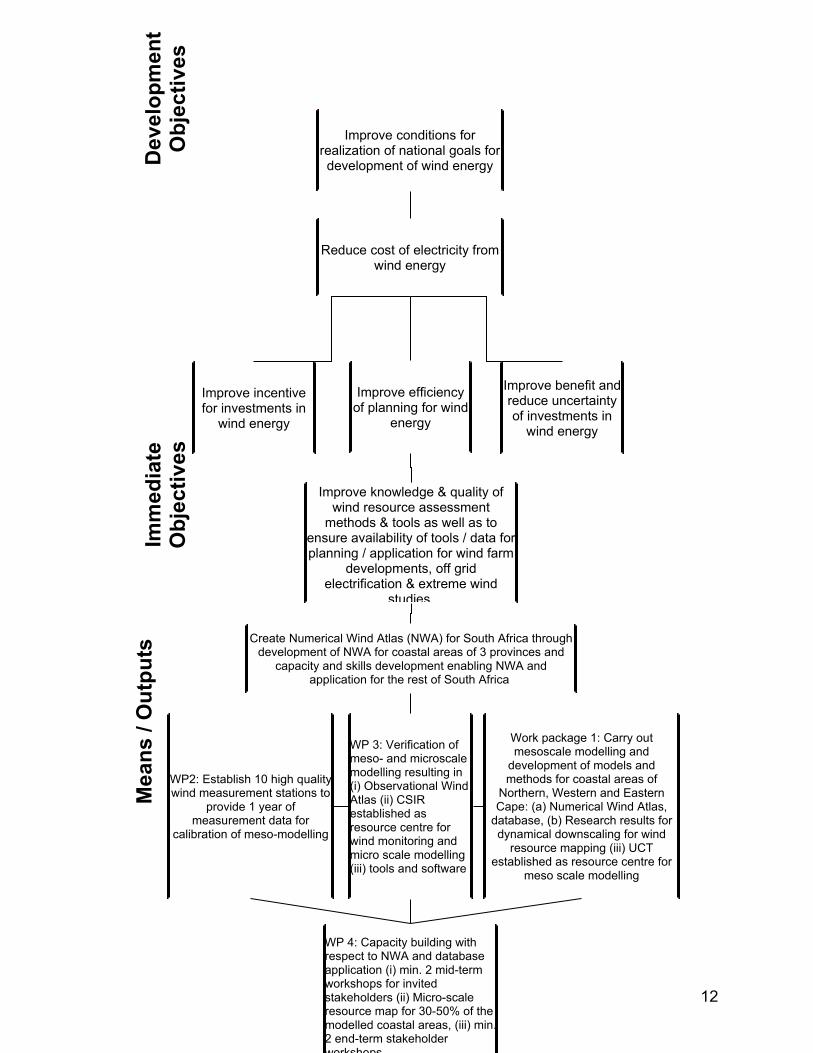
2 ObjectivesThe main aim of the twinning programme is to develop and employ numerical wind atlas methods and develop capacity to enable planning of large-scale exploitation of wind power in South Africa, including dedicated wind resource assessment and siting tools for planning purposes, i.e. a Numerical Wind Atlas and database for South Africa.
The objective tree shown below reflects how the project can contribute to the development objectives through the project’s immediate objectives, achieved through four main projects, namely: WP1) mesoscale wind modelling, WP2) wind measurements, WP3) micro scale wind modelling and WP4) application for wind resource assessment, - each associated with extensive capacity, skills and research development.
Furthermore WP5 and WP6 are added, which contains the following means / outputs:
• WP5 Extreme wind atlas: (i) Map of estimation of the extreme wind climate of South Africa for coastal areas of Northern, Western and Eastern Cape with mesoscale model data
• WP6 Documentation and dissemination: (i) Research publications of the results of the twinning programme, incl. final book and homepage publication; (ii) Min. 1 national wind seminars for dissemination of the results of the twinning programme; and (iii) Establishment and documentation of research cooperation between South African and international wind research partners.
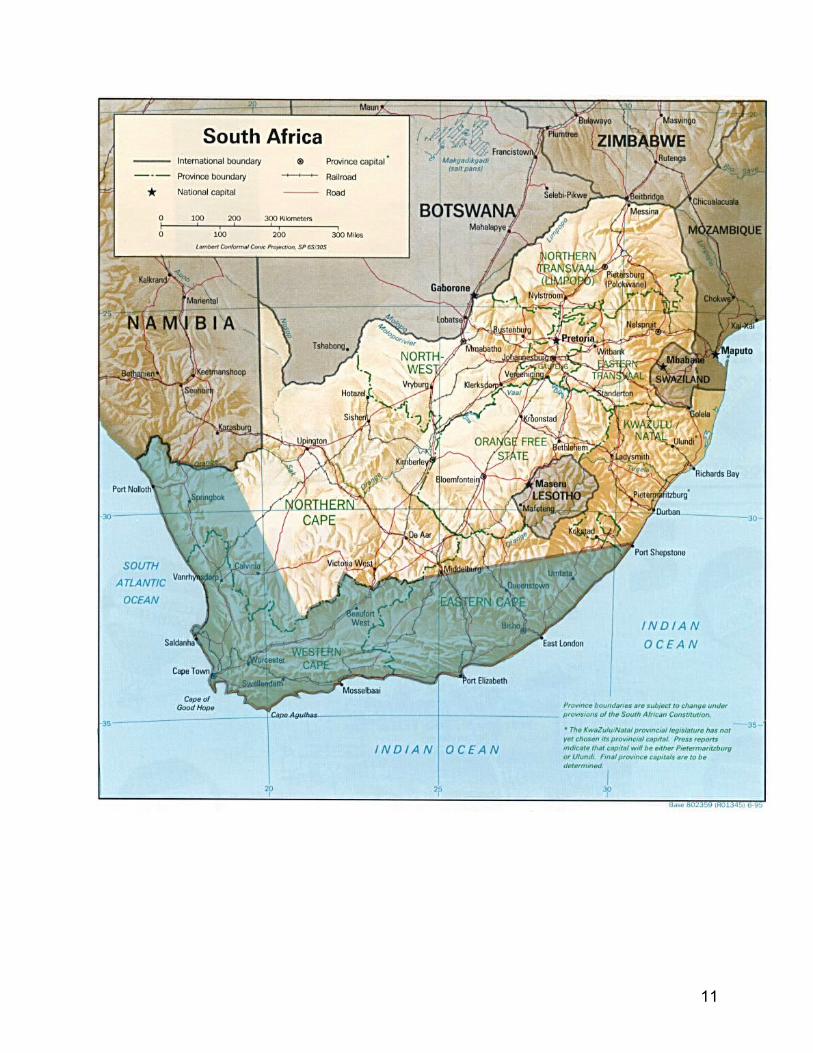
Figure 1 WASA project area: Western Cape and areas of Northern and Eastern Cape
10
11
12
Improve conditions for realization of national goals for development of wind energy
Reduce cost of electricity from wind energy
Improve efficiency of planning for wind
energy
Improve incentive for investments in
wind energy
Improve knowledge & quality of wind resource assessment
methods & tools as well as to ensure availability of tools / data for planning / application for wind farm
developments, off grid electrification & extreme wind
studies
Improve benefit and reduce uncertainty of investments in
wind energy
Create Numerical Wind Atlas (NWA) for South Africa through development of NWA for coastal areas of 3 provinces and
capacity and skills development enabling NWA and application for the rest of South Africa
WP2: Establish 10 high quality wind measurement stations to
provide 1 year of measurement data for
calibration of meso-modelling
WP 4: Capacity building with respect to NWA and database application (i) min. 2 mid-term workshops for invited stakeholders (ii) Micro-scale resource map for 30-50% of the modelled coastal areas, (iii) min. 2 end-term stakeholder workshops
WP 3: Verification of meso- and microscale modelling resulting in (i) Observational Wind Atlas (ii) CSIR established as resource centre for wind monitoring and micro scale modelling (iii) tools and software
Work package 1: Carry out mesoscale modelling and
development of models and methods for coastal areas of
Northern, Western and Eastern Cape: (a) Numerical Wind Atlas,
database, (b) Research results for dynamical downscaling for wind
resource mapping (iii) UCT established as resource centre for
meso scale modelling
Mea
ns /
Out
puts
D
evel
opm
ent
Obj
ectiv
esIm
med
iate
O
bjec
tives
3 Scope of workThe project has a scope of work, which falls into six key Work Packages (WP):
WP1 – Mesoscale wind modelling• Wind classes• Terrain elevation• Terrain roughness• Model configuration• KAMM /WRF/WAsP statistical/dynamical downscaling• WRF – dynamical downscaling • Methods for satellite data input to mesoscale models • Post-processing of mesoscale outputs – coupling to microscale model• Mesoscale results vs. measured data• Creation of a Numerical Wind Atlas for Western Cape and areas of Northern and
Eastern Cape• Training, including exchange of PhD’s.
WP2 – Wind measurements• Design of wind measuring system • Design of data acquisitions by GSM • Procurement, shipment, customs clearance, tax and VAT exemption, necessary
import permits • Survey, screening and selection (if appropriate) of existing data from private
measurements, agreement and confidentiality and value of data• Siting and necessary approvals • Consideration of appropriate mast design• Construction and installation• Recalibration • Operation, security and data collection• Data analyses• Technical training – upgrade with respect to wind energy related measurement
systems.
WP3 – Micro scale wind modelling• Wind speed and direction distributions• Terrain elevation• Terrain roughness• Sheltering obstacles• WAsP modelling• Microscale results vs. measured data• Creation of Observational Wind Atlas for selected measurement sites in South
Africa
13
• WAsP training (Training of Trainers – ToT).
WP4 – Application for wind resource assessment• Mid-term Workshops for invited stakeholders from e.g. authorities, planners,
developers, banks, scientists, etc.• Develop tools - guidelines and training materials – for CSIR courses on using the
Numerical Wind Atlas for wind resource assessment • Course for trainers• Micro-scale resource map for 30-50% of the modelled areas in the three
provinces, incl. integration as GIS layer• Seasonal variation of wind resources at the mast locations• Final Workshops and training of trainers for invited stakeholders, incl.
opportunities for application in determination of extreme wind climate; seasonal forecasting; and other than wind energy.
WP5 – Extreme winds• Develop tools and guidelines• Course for trainers• Workshops as technical working sessions and progress reporting for PIU• Better understanding of the estimation of extreme winds• Capacity development of theoretical aspects of extreme wind estimation• Application of mesoscale modelling results to the estimation of an extreme wind
climate of South Africa – coastal areas of Northern, Western and Eastern Cape.
WP6 – Documentation and dissemination • Prepare and disseminate research publications of the results of the twinning
programme, incl. final book and homepage publication • Prepare national wind seminars for dissemination of the results of the twinning
programme• Establish and document research cooperation between South African and
international wind research partners.
Further detail on the scope of work is provided in sections below.
4 Methodology and Implementation
4.1 StrategyThe project contains two key strategies. The first strategy is to twin UCT, CSIR and SAWS and Risø DTU for strategic capacity, skills and research cooperation within national wind resource mapping. Specifically this includes twinning between the following key partners.
14
(i) Twinning of UCT and Risø DTU expertise in mesoscale modelling, which initially aims at interaction to employ the Wind Atlas methodology, which will develop and refine the adaptation of the Numerical Wind Atlas and the models applied.
(ii) Twinning of CSIR and Risø DTU to create a thorough understanding of the Risø DTU numerical wind atlas methodology and the merits and limitations of WAsP and other microscale models, which will be achieved through a detailed run through of the necessary steps of the methodology and through detailed analyses of the state-of-the-art wind measurements obtained at 10 meteorological masts which will be installed in Northern, Eastern and Western Cape. The network of 10 new meteorological stations is intended to provide a unique, high-quality database of wind measurement. In order to secure high quality of these and future CSIR measurement programs related to wind energy application, masts will be equipped with sensors living up to MEASNET requirements. Measurement systems will be designed jointly by CSIR and Risø DTU.
(iii) Twinning of SAWS and Risø DTU in the field of extreme wind studies. This will include research cooperation and capacity building at SAWS in dissemination of know-how in application of mesoscale modelling and statistical wind analysis techniques for extreme wind studies.
It is expected that the cooperation between the above four research institutions will be long-term due to mutual interest and the potential and need for this type of work.
The second key strategy is to utilise the results of the twinning arrangement for capacity development of (i) the national, regional and local governmental stakeholders with mandates for development of the utilisation of the wind resource in South Africa, and (ii) the established national wind spoke for South Africa consisting of e.g. Cape Town and Stellenbosch Universities. SANERI will be the key institution responsible for this transforming of the results to these key stakeholders.
Furthermore will SAWEP under this strategy be placed with the responsibility to utilise the results of the twinning arrangement for general capacity development of the wind industry sector, hereunder the national wind industry association, SAWEA.
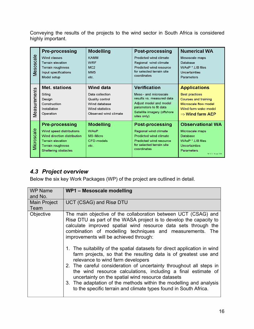
4.2 MethodologyThe diagram below summarises the four first work packages of Mesoscale, Measurements, Micro scale, and Application, leading to the necessary verification and results presented, and made available in the form of a Numerical Wind Atlas as well as an Observational Wind Atlas. The network of the 10 high quality measurement stations is expected to be supplemented with other stations made available to the project by developers. Further to the four work packages shown in the diagram, does the project include a fifth work package regarding Extreme Winds.
In the end emphasis will be placed on the fourth work package; application for planning of wind energy – aimed at authorities, planners, developers, banks and investors.
15
Conveying the results of the projects to the wind sector in South Africa is considered highly important.
4.3 Project overviewBelow the six key Work Packages (WP) of the project are outlined in detail.
WP Name and No.
WP1 – Mesoscale modelling
Main Project Team
UCT (CSAG) and Risø DTU
Objective The main objective of the collaboration between UCT (CSAG) and Risø DTU as part of the WASA project is to develop the capacity to calculate improved spatial wind resource data sets through the combination of modelling techniques and measurements. The improvements will be achieved through: 1. The suitability of the spatial datasets for direct application in wind
farm projects, so that the resulting data is of greatest use and relevance to wind farm developers
2. The careful consideration of uncertainty throughout all steps in the wind resource calculations, including a final estimate of uncertainty on the spatial wind resource datasets
3. The adaptation of the methods within the modelling and analysis to the specific terrain and climate types found in South Africa.
16
WP Name and No.
WP1 – Mesoscale modelling
The first central result of this collaboration will be wind resource data sets and maps for Western Cape and areas of Northern and Eastern Cape, performed mainly by Risø DTU employing the Risø method.
Scope of Work
• Wind classes• Terrain elevation• Terrain roughness• Model configuration• KAMM/WRF/WAsP – at Risø DTU• Downscale WRF – at UCT(CSAG) and Risø DTU• Post processing and coupling of mesoscale outputs• Validation of mesoscale results vs. measured data • Creation of a Numerical Wind Atlas for Western Cape and
areas of Northern and Eastern Cape, South Africa• Training – exchange of PhDs
Work Plan BackgroundBoth UCT(CSAG) and Risø have experience in the use and application of regional/mesoscale models, microscale models and observations. The UCT (CSAG) team has extensive knowledge of understanding climate processes in South Africa.Risø has been active for decades in the area of wind resource mapping, and has developed the WAsP software, a microscale modelling tool for wind farm energy calculations, and the KAMM/WAsP method, for the calculation of wind resources over large areas.The KAMM/WAsP system output is compatible with WAsP, which allows mesoscale results to be applied all the way down to the microscale for wind farm energy calculations. Risø is now beginning to use the WRF mesoscale model in wind energy studies, and this model is seen as a likely successor to the KAMM mesoscale model.UCT (CSAG) has also been engaged in mesoscale/regional climate modelling activities for various downscaling applications, including some in wind energy resource assessment. The mesoscale studies will follow two parallel paths. Risø, in collaboration with UCT (CSAG), will apply the existing KAMM/WRF/WAsP system to develop a wind Atlas for Western Cape and areas of Northern and Eastern Cape. At the same time, both institutions will collaborate in the development a new methodology using dynamical downscaling using WRF and WAsP.Because UCT (CSAG) has experience in the application of mesoscale modelling to regional climate and the observed weather and climate of South Africa, the collaboration should give rise to
17
WP Name and No.
WP1 – Mesoscale modelling
mutual learning. From the mesoscale point of view, UCT (CSAG) will gain from Risø’s knowledge and experience of the WRF/WAsP method and application of WRF, and Risø will gain from the experience gained from UCT (CSAG)’s use of MM5 and WRF. Part A. Numerical wind atlas methodology (current technology)The methodology can be broken down into four distinct steps:
Pre-processing; the selection of the wind classes used to represent the large-scale meteorological conditionsMesoscale simulation; the calculation of wind fields over the terrain for each of the wind classes. Terrain resolution is typically 5 km, but other resolutions can be usedPost-processing; the analysis of the results of the mesoscale simulations in order to create wind atlas maps and datasets for direct application of WAsP or possibly other microscale modelsVerification; comparison of the mesoscale-derived wind data with observation-based wind data.All four parts will be covered in detail by Risø, but relying on the South African weather and climate knowledge of UCT (CSAG), SAWS and other WASAPT members.Part B. Dynamical downscaling for wind resource mapping UCT (CSAG) and Risø will jointly engage in the development of a new methodology for wind power resource assessment using dynamical downscaling with WRF and a new coupling strategy to WAsP. Since this task represents a new research area for both UCT (CSAG) and Risø, the exact procedure to be followed is uncertain, but it will contain the following topics:1. Setup and sensitivity studies:
a. Determination of optimal parameters and parameterizations (in particular surface parameters, boundary layer and convection parameterizations) for wind energy resource assessment (from shorter duration case studies and extended runs on coarse grid)
b. Determination of optimal grid configuration and resolution, and optimal parameters for analysis nudging (nudging parameters, cut-off level)
c. Determination of the impact of high-resolution “static” data, including satellite-derived sea surface temperatures and vegetation characteristic (including vegetation phenology, in collaboration with CSIR group), to the short and long-term simulations
18
WP Name and No.
WP1 – Mesoscale modelling
2. Mesoscale/local process studies. Additional studies of various modelling issues (impact of stratus deck on the development of local circulations, etc.)
3. Climate downscaling. Perform a multi-nested climate downscaling simulation (with grid spacing ranging from 45 to 5 km) for southern Africa. The downscaling strategy will use the standard Advanced Research WRF (Weather Research & Forecasting) model and the NCEP/NCAR reanalysis for initial/boundary conditions and large-scale grid nudging. The large-scale domain will include all southern Africa and surrounding oceans and up to two nesting levels. The innermost nesting level will contain two high-resolution (~5 km) domains for Western Cape and areas of Northern and Eastern Cape. The precise size, position, and resolution will be determined later from results of sensitivity experiments (1a) and the process studies, the available computational resources and the time required to complete of the project
4. Coupling to microscale. Develop the optimal coupling strategy between the mesoscale wind climatographies obtained from the climate downscaling runs in 1 and the microscale model and wind atlas methodology.
5. Seasonal and interannual variation of wind climate. Understanding the seasonal and interannual variability of the wind climate by analysis of the NCEP/NCAR reanalysis and the output of the dynamical downscaling
6. Statistical-dynamical downscaling. Collaboration in the assessment of statistical-dynamics downscaling methods through leveraging current work with Self Organizing Maps and other categorical approaches to high resolution modelling.
Throughout this collaboration between UCT (CSAG) with Risø, UCT (CSAG) will be a full partner in the results of the dynamical downscaling research and stand to benefit directly from the findings that come from them.Quality assessment Throughout this project, much attention will be given to the quality of the wind resource estimation. As much as possible uniformity in quality is the objective. Therefore, the specific nature of the difference test areas needs to be addressed. For example, different terrain types and climate types will quite possibly require a different
19
WP Name and No.
WP1 – Mesoscale modelling
treatment.Methods for estimating the likely uncertainty of the wind resource data will be developed. One possibility of how to do this is to employ the sensitivity studies mentioned in the previous section as part of the input to the uncertainty calculations. This aspect of the collaboration is an innovative and much desired part of a wind mapping procedure.
Inputs • Equipment (local clusters at Risø and UCT (CSAG); use of high performance cluster at CHPC)
• Data from project WP2• Terrain and vegetation data; satellite-derived SSTs• Reanalysis data; land surface soil moisture data• Standard synoptic/climate data for verification • Regional wind climates (WAsP *.lib files)• Predicted wind resource for selected terrain site coordinates• Maps and database for Western Cape and areas of Northern
and Eastern Cape• Uncertainties• Parameters
Outputs 1. Numerical Wind Atlas for Western Cape and areas of Northern and Eastern Cape (e.g. report, web site, poster, fact sheets, etc.)
2. Research results for Dynamical downscaling for wind resource mapping for Western Cape and areas of Northern and Eastern Cape
Indicators & means of verification
• Research reports and training packages approved• Maps and database completed and made available in public
domain• Final project report published and made available in public
domain• Project completion and evaluation report completed• Financial audit report without qualifications received
Prerequisites and context
Data accessible within budgeted meansAll UCT(CSAG) and Risø DTU resources made available to the extent included in these TORsAll findings to be put in public domain.
Related WASA activities
This project is depending upon project WP2 and related to WP3-WP6.
Remarks None
20
WP Name and No.
WP2 – Measurements
Main Project Team
CSIR and Risø DTU
Objective Capacity building at CSIR in high quality wind measurements and providing input for WP1 and WP3 (mesoscale and micro-scale modelling projects)
Scope of Work
• Design of measuring system by CSIR and Risø DTU• Design of data acquisitions by GSM or satellite by CSIR and
Risø DTU• Procurement, shipment, customs clearance, tax and VAT
exemption, necessary import permits • Existing measurements and confidentiality of data• Siting and necessary approvals, e.g. NEMA Act regulations,
Basic Assessment• Reassessment of structural design requirements for masts • Construction and installation• Operation and data collection• Data analyses• Technical training – CSIR upgrade with respect to wind
energy related measurement systems.Work Plan 1. Siting – a cooperation effort between WP1, WP2 and WP3,
especially regarding setting up of the criteria. CSIR and Risoe DTU will carry out site selection for 3 sites jointly after which CSIR will complete the siting for the remaining stations.
2. EIA-Basic assessment initiation.3. All 10 sites shall try to be located in areas with GSM mobile
phone coverage, but manual retrieval of data using flash cards will be possible
4. Conceptual design of masts – particularly in respect of lightning protection measures
5. CSIR will deliver the 10 masts. The height is expected to be between 50 and 70 m and of lattice type guy wired designed for climbing by trained technicians. (free standing is considered a not preferred solution)
6. CSIR will contract the construction and erection works for the 10 meteorological masts, including foundation, fencing, access roads, etc.
7. Risø DTU will design the necessary data measuring systems in cooperation with CSIR
8. CSIR will procure the needed mounting booms and clamps for the equipment according to a technical specification from Risø DTU
9. Risø DTU will deliver equipment for 10 dedicated wind resource measurement stations and additional equipment as
21
WP Name and No.
WP2 – Measurements
spare parts. Support fixtures and cables are included for all sensors
10.All Risø cup anemometers are wind tunnel calibrated in Denmark prior to delivery
11.CSIR will arrange and cover costs of recalibration after 3 years – expected to be performed in suitable SA wind tunnel with an unused recently calibrated Risø cup anemometer serving as reference for comparison
12.The Risø DTU equipment will be shipped from Denmark to SA and CSIR will take over the ownership and all liabilities from the point of entry in SA
13.CSIR will do all custom clearance, local transport, land acquisition or rental, arrange access, insurance of equipment, guarding and permissions as well as arrange that the site is safe for work – all free of charge (or cost of any kind) for Risø DTU
14.GSM network coverage on all the selected sites is assumed.15.CSIR will procure GSM SIM cards with data transfer for all
stations and this includes all costs related to the local data transfer in SA
16.State of the art wind measuring technique will be introduced by Risø DTU mainly as “on the job training” at one mast in one of the 10 selected sites – preferably near CSIR/Stellenbosch
17.Training will be at ground level meaning up to 10 m above the surface. The actual physical installation of all the equipment in all masts will be carried out by CSIR staff, i.e. climbing and installations up to the top of the masts
18.The dataflow is suggested to be centralised at CSIR in Stellenbosch. Here a database system will be set up on a server and on-line Web display software will give data access to all the relevant partners in the WASA project
19.Risø DTU will deliver a PC to be installed at CSIR. This PC includes the needed software to communicate and download data from the stations using the GSM network
20.CSIR will handle the received data and will be responsible for performing quality control (operation checked every working day/quality checked weekly) to ensure an uninterrupted high data quality during the three years of measurements.
Inputs • Infrastructure for met stations• Notebook PCs for data collection and analyses• Database and web display software • Statistics• Observed wind climates• Report on measurements
22
WP Name and No.
WP2 – Measurements
Outputs 1. Establish 10 high quality wind measurement stations providing three years of measurement data for calibration of meso-modelling
2. A database system for wind data collection and on-line Web display.
Indicators & means of verification
• Training mission report delivered• Valid data for three full years is delivered• Project completion and evaluation report completed
Prerequisites and context
Necessary import approvals are obtained.All findings to be put in public domain. This includes databases resulting from the measurements that shall be made available to application both for private and public users.
Related WASA activities
This project is closely related to and depending upon projects WP1 and WP3. It provides input for WP4 and WP6.
Remarks CSIR will be the owner of measurement equipment and a collaboration agreement will be established with SAWEA, including the necessary consideration regarding which stations should remain as reference stations and which that may be moved to other locations.The general layout of a met mast to be defined in close cooperation between CSIR and Risø DTU..
WP Name and No.
WP3 – Microscale Modelling
Main Project Team
CSIR and Risø DTU
Objective To develop the capacity to calculate improved observational wind atlas data sets and improved predicted wind climates through the combination of micro scale modelling techniques and state-of-the-art wind measurements. The improvements will be achieved through:1. The suitability of measured data sets for wind atlas analysis and
application, so that the resulting data and procedures are of greatest use and relevance to wind farm developers. State-of-the-art equipment will be employed so as to minimise the uncertainty in the wind measurements
2. The careful consideration of uncertainty throughout all steps of the wind atlas and wind resource calculations, including a final estimate of the uncertainty on the observed, regional and predicted wind resource estimates
3. The adaptation of the methods within the modelling and analyses to the specific terrain and climate types found in South Africa.
23
WP Name and No.
WP3 – Microscale Modelling
The central result of this collaboration will be wind resource data sets and local maps for no less than 10 sites in the Northern, Eastern and Western Cape in South Africa. If more relevant data from other met stations developers can be made available, this will strengthen the observational wind atlas.
Scope of Work
• Wind speed and direction distributions• Terrain elevation• Terrain roughness• Sheltering obstacles• WAsP modelling• Microscale results vs. measured data• WAsP training• Creation of Observational Wind Atlas for selected
measurement sites in South AfricaWork Plan Background
Risø DTU has developed the microscale modelling tool WAsP. An important part of the capacity building of the collaboration will be a thorough understanding of the merits and limitations of WAsP and other microscale models and of the wind atlas methodology. This can be achieved through detailed analyses of the state-of-the-art wind measurements obtained at 10 tall met. masts which are going to be installed in the three provinces of South Africa as part of the project. This network of tall masts should provide a unique, high-quality database of wind measurements against which the microscale models and methodologies can be tested and verified.Because CSIR has vast experience in South African climatological conditions, and will gain experience in other microscale models during the project, the collaboration should give rise to mutual learning. From the measurements point of view CSIR will gain experience in the special requirements and instruments related to state of the art wind measurements for wind power applications. From the micro scale point of view, CSIR will gain from Risø DTU’s knowledge and experience of the industry-standard WAsP software.Observational wind atlas methodology. The methodology can be broken down into four key steps:
1. Pre-processing; the construction of wind speed and direction distributions used to represent the observed meteorological conditions. Construction of the small-scale terrain descriptions of the terrain around the meteorological station: elevation map, roughness length map and specification of sheltering obstacles
24
WP Name and No.
WP3 – Microscale Modelling
2. Microscale modelling; the calculation of the effects of the terrain descriptions on the wind climate observed at the meteorological station. The WAsP modelling is typically done with standard modelling parameters, but other parameter settings can be applied
3. Post-processing; the analysis of the results of the microscale simulations in order to create wind atlas data sets for direct application with WAsP. Steps 2 and 3 are carried out in one process in the WAsP software
4. Verification; the comparison of the microscale-derived wind speed and direction distributions with observation-based wind distributions.
All four parts will be covered in detail in the collaboration between CSIR and Risø DTU.Sensitivity studies. In the chosen test areas, trials of various different methods within steps 1-3 above will be carried out. This work will be undertaken by Risø DTU or CSIR as appropriate.Thus, the sensitivity of the wind resource calculations to a single change in one of the methods in steps 1, 2 or 3 can be assessed. To elaborate on this point the following examples are given:1. Pre-processing; sensitivity of the microscale modelling to
elevation and roughness length descriptions derived from different data sources, e.g. topographical maps, SRTM elevation data, satellite imagery, etc.
2. Microscale modelling; sensitivity to physical parameterization schemes within the models, etc. WAsP parameter studies
3. Post-processing; sensitivity to the standard heights and roughness classes used for establishing the regional wind climates, sensitivity to the terrain descriptions, etc.
4. Verification; the sensitivity of the comparisons to climatological or topographical characteristics of the different sites, e.g. atmospheric stability or ruggedness index, distance to the reference mast, etc.
Indeed, testing all possible combinations of these sensitivities would be a very big task. However, it will be possible to select a subset of combinations and still gain a tremendous amount of understanding of how uncertainties come about in the methodologies.CSIR and Risø DTU will be full partners in the analyses and results of this work, and both stand to benefit directly from the findings that come from them.Quality assessment
25
WP Name and No.
WP3 – Microscale Modelling
Throughout the project much attention will be given to the quality of the wind measurements and of the wind resource estimation. As much as possible uniformity in quality is the objective. Therefore the specific nature of the different test areas needs to be addressed. For example different terrain types and climate types will quite possibly require a different treatment.Methods for estimating the uncertainty of the wind resource will be developed. One possibility of how to do this is to employ the sensitivity studies mentioned in the previous section as part of the input to the uncertainty calculations.This aspect of the collaboration is an innovative and much desired part of current wind resource assessment and siting procedures – in South Africa and worldwide.
Inputs • WAsP software packages (4)• WAsP Engineering software packages (4)• Surfer/Global mapper software package (1)• Desktop PCs for microscale modelling (2) • Regional wind climates (WAsP *.lib files)• Predicted wind resource for selected terrain site coordinates• Maps and database for Western Cape and areas of Northern
and Eastern Cape • Uncertainties.
Outputs 1. Observational Wind Atlas for Western Cape and areas of Northern and Western Cape in South Africa, e.g. report, web site, poster fact sheets
2. CSIR established as national resource centre for micro scale modelling.
Indicators & means of verification
• Training report approved • Maps and database for test region in for Western Cape and
areas of Northern and Western Cape in South Africa are published
• Project completion and evaluation report completed• Financial audit report without qualifications received
Prerequisites and context
Necessary data accessible.All findings to be put in public domain
Related WASA activities
This project is closely related to and depending upon projects WP1 and WP2. It provides input for WP4.
Remarks None
26
WP Name and No.
WP4 – Application
Main Project Team
CSIR and Risø DTU
Objective Capacity building at CSIR (Pretoria) and SAWS in dissemination of know-how in application of mesoscale and microscale modelling and wind measurement techniques for wind resource assessment
Scope of Work
• Mid-term Workshops for invited stakeholders from e.g. authorities, planners, developers, banks, scientists, etc.
• Develop tools - guidelines and training materials – for CSIR courses on using the Numerical Wind Atlas for wind resource assessment
• Course for trainers• Micro-scale resource map for 30-50% of the modelled coastal
area in the three provinces, incl. integration as GIS layer – the actual transformation to and implementation in GIS is a separate CSIR activity
• Seasonal variation of wind resources at the mast locations• Workshops as technical working sessions and progress
reporting for PIU• Final Workshops for invited stakeholders
Inputs • Results from WP1, WP2 and WP3 • Tools-software with guidelines and help• Course materials • Report on best practice• Resource maps prepared for introduction as GIS layer.
Outputs 1. Min. 2 mid-term workshops for invited stakeholders from e.g. authorities, planners, developers, banks, scientists, etc.
2. Micro-scale resource map for 30-50% of the modelled areas in the three provinces
3. Min. 2 end-term workshops for invited stakeholders from e.g. authorities, planners, developers, banks, scientists, etc.
Indicators & means of verification
Tools-software with guidelines and course materials are developed.Training report approved.Project completion and evaluation report completed.Audit clearance received.
Prerequisites and context
Timely completion of WP1, WP2 and WP3 projects.All findings to be put in public domain.
Related WASA activities
This project is closely related to and depending upon projects WP1, WP2, WP3 and WP6.
Remarks None
27
WP Name and No.
WP5 – Extreme wind atlas
Main Project Team partner
SAWS and Risø DTU
Objective Capacity building at SAWS in dissemination of know-how in application of mesoscale modelling and statistical wind analysis techniques for extreme wind studies.
Scope of Work
• Better understanding of the WAsP engineering software, specifically regarding the estimation of extreme winds
• Capacity building through training of theoretical aspects of extreme wind estimation
• Application of mesoscale modelling results (from WP1) to the estimation of an extreme wind climate of South Africa –coastal areas of Northern, Western and Eastern Cape.
Inputs • Observed wind distributions• Reanalysis data• Output from mesoscale WP1 • Software and data with guidelines and help
Outputs 1. Map of estimation of the extreme wind climate of South Africa for coastal areas of Northern, Western and Eastern Cape with mesoscale model data
Indicators & means of verification
• Tools-software with guidelines and course materials are developed
• Tools-software are applied• Project completion and evaluation report completed• Audit clearance received
Prerequisites and context
Timely completion of WP1, WP2, WP3 and WP4 projects.All findings to be put in public domain.
Related WASA activities
This project is closely related to and depending upon projects WP1, WP2, WP3 and WP4.
Remarks None
WP Name and No.
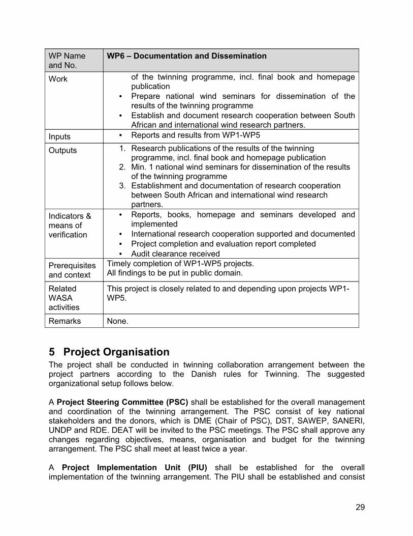
WP6 – Documentation and Dissemination
Main Project Team partner
SANERI with Risø DTU, CSIR, CTU, SAWS and other key stakeholders (see chapter 1)
Objective National and international capacity and knowledge building through dissemination of results and know-how in application of meso- and micro scale modelling results.
Scope of • Prepare and disseminate research publications of the results
28
WP Name and No.
WP6 – Documentation and Dissemination
Work of the twinning programme, incl. final book and homepage publication
• Prepare national wind seminars for dissemination of the results of the twinning programme
• Establish and document research cooperation between South African and international wind research partners.
Inputs • Reports and results from WP1-WP5
Outputs 1. Research publications of the results of the twinning programme, incl. final book and homepage publication
2. Min. 1 national wind seminars for dissemination of the results of the twinning programme
3. Establishment and documentation of research cooperation between South African and international wind research partners.
Indicators & means of verification
• Reports, books, homepage and seminars developed and implemented
• International research cooperation supported and documented• Project completion and evaluation report completed• Audit clearance received
Prerequisites and context
Timely completion of WP1-WP5 projects.All findings to be put in public domain.
Related WASA activities
This project is closely related to and depending upon projects WP1-WP5.
Remarks None.
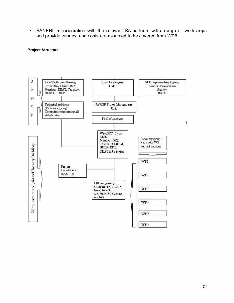
5 Project Organisation The project shall be conducted in twinning collaboration arrangement between the project partners according to the Danish rules for Twinning. The suggested organizational setup follows below.
A Project Steering Committee (PSC) shall be established for the overall management and coordination of the twinning arrangement. The PSC consist of key national stakeholders and the donors, which is DME (Chair of PSC), DST, SAWEP, SANERI, UNDP and RDE. DEAT will be invited to the PSC meetings. The PSC shall approve any changes regarding objectives, means, organisation and budget for the twinning arrangement. The PSC shall meet at least twice a year.
A Project Implementation Unit (PIU) shall be established for the overall implementation of the twinning arrangement. The PIU shall be established and consist
29
of one representative from each of the twinning parties (UCT, CSIR, SAWS, and Riso DTU) as well as the project coordinator (SANERI). SAWEP and the donors are invited to the PIU meetings. The PIU shall meet twice a year or more often as required. Meetings shall be arranged to allow for participation of Working Group members to the degree possible and relevant and if possible in connection with workshops. The PIU is overall responsible for achieving the defined objectives within the budget and time frame defined.
Working Groups (WG) shall be established for the implementation of each of the six working packages. The WGs shall consist of dedicated experts from the twinning partners, and shall meet as often as required for a timely and high quality execution of the tasks for the WG. A Work Group Project Manager (WGPM) shall be established for each Work Group. Detailed work plans for the six work packages, appointment of qualified members of the working groups and decisions during the project implementation regarding work packages and activities shall be presented for approval by the PIU within the framework of this Project Description.
A Project Coordinator (PC) shall be appointed to assist with the coordination of the PIU activities. SANERI will undertake the PC role, and at the same time be Work Group Project Manager for Work Group 6.
A Reference Group (RG), comprising the SAWEP Project Advisory Committee (PAC), may be established for the guidance of the twinning arrangement. The RG should consist of key national, provincial and municipal stakeholders, the private sector, and key national or international experts. The RG should meet at least once a year.
6 Reporting and Financial Management The PIU shall report to the PSC twice a year and as per project milestone achieved through progress reports documenting the status regarding objectives, means, work group activities, time plan and budget. The PIU shall at the end of the twinning arrangement prepare a completion report documenting the completion status regarding objectives, means, work group activities, time plan and budget. The completion report shall further contain a discussion of impacts and the way forward for wind resource mapping in South Africa.
Financial Management for funds received from UNDP or RDE shall follow standard conditions for payments from these donor organizations. For RDE funding the funding amount is fixed in Danish Kroner. Payment will be as per milestone achieved as reported through the PSC meetings with an advance payment at project start. SAWEP funds are planned to be utilized before February 2010.
Co-financing for implementation of programme activities is obtained from; (i) Risø DTU as described in section 1.6, (ii) SANERI undertaking the activities pertaining to programme management and coordination free of charge, and (iii) SAWEP undertaking activities supporting programme management and coordination free of charge.
30
Financial support from UNDP is allocated to the CSIR component, while RDE funding is secured for the other components. A 5 % contingency have been added for the CSIR component due to insecurities regarding pricing of the physical instalment for this component. A 5 % contingency have been applied for the RDE funding.
7 Intellectual Property RightsIt shall be noted that Intellectual Property rights for all outcomes and results of the Twinning Arrangement shall follow standard Danish and South African Intellectual Property right rules and regulations for inter-governmental twinning research programmes. The Numerical Wind Atlas and database, micro scale resource map and database and the map of extreme wind climate and database will be made publicly available.
8 Requirements and assumptionsIt is assumed that:
• Project commencement 01 November 2008• Financing will be secured• Contract agreement made between partners• Financing for Risø’s co-financing will be secured.• Project Team partners can agree to collaborate and implement the project in
coordination• Twinning is established between UCT and Risø DTU with research with
publications• Major parts of existing wind data are applicable for wind atlas purposes• IPR of pre-existing knowledge and methods remain with the institution. Shared
ownership applies to any new knowledge developed jointly – if developed in this project by one partner only; the ownership belongs to that partner
• Measurement equipment to be procured by CSIR and supplied by Risø DTU can be imported to South Africa free of charge (or cost of any kind) for Risø DTU and for the project
• Risø DTU responsibility for equipment while in South Africa (from point of entry) will only be related to equipment warranty for correct functioning, and thus ownership will be passed to the project and CSIR from customs clearance
• CSIR will do all customs clearance, local transport in South Africa, land acquisition or rental, arrange access and permissions, arrange that land is safe for work and traffic, insurance and security, arrange procurement and erection of masts on appropriate jointly selected sites – all costs included according to the agreed budget
• Masts are of lattice type designed for climbing by trained technicians for installation of measurement equipment
• CSIR will ensure permissions and arrange for GSM communication• CSIR will arrange and provide contractors and technicians for installation of masts
and for installation of measurement equipment • UCT and CSIR will maintain and disseminate the Numerical Wind Atlas in
cooperation
31
• SANERI in cooperation with the relevant SA-partners will arrange all workshops and provide venues, and costs are assumed to be covered from WP6.
Project Structure
32
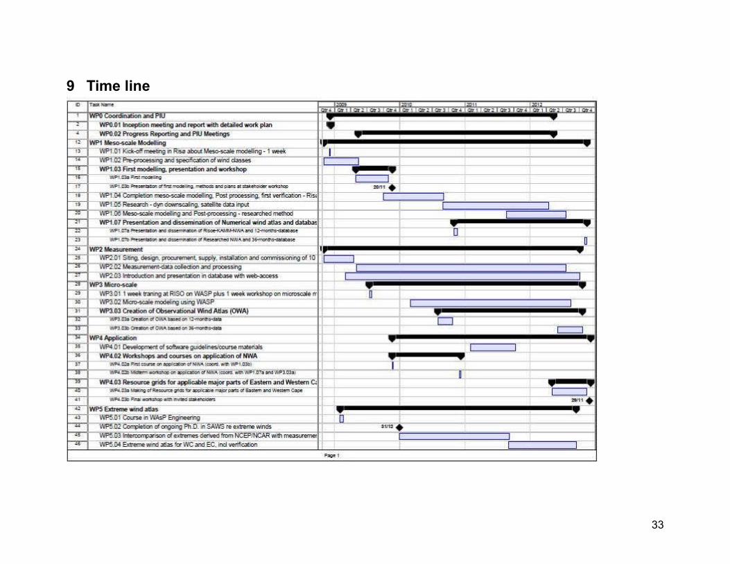
9 Time line
33
10 Signature pageObjective:The main objective of the Project is, through a collaborative effort of national and international parties, to develop and employ numerical wind atlas methods and develop capacity to enable planning of large-scale exploitation of wind power in South Africa, including dedicated wind resource assessment and siting tools for planning purposes, i.e. a Numerical Wind Atlas and database for South Africa that can be used for feasibility studies and in support of bankable projects.
Expected Outputs:• Numerical Wind Atlas (NWA) and database for the Western Cape Province and selected areas of the
Northern Cape and Eastern Cape Provinces, including seasonal variations and resource maps prepared for introduction as GIS layer.
• Micro scale resource map and database for 30-50% of the modelled areas in the three provinces• Map and database of extreme wind climate of the modelled areas in the three provinces• 10 High quality wind measurement masts and data collection operational• Minimum 2 mid term and 2 end term workshops for invited participants in the application of the
NWA and database• The CSIR established as a resource centre for micro scale modeling• The UCT established as a resource centre for meso scale modeling• Training tools and software• Research publications of the results of the twinning programme, incl. final book and home page
publication• Minimum 1 national wind seminar for dissemination of the results of the twinning programme• Establishment and documentation of research cooperation between South African and International
research partners
Project Period: November 2008 to December 2012Project Title:Wind Atlas for South AfricaProject Duration:4 yearsManagement Arrangement:Wind Atlas Project Steering Committee