59
Without Borders Integrated Environmental Planning Throughout Greater Saint John Yvonne Reeves & Graeme Stewart-Robertson
| Date post: | 30-Jul-2016 |
| Category: |
Documents |
| Upload: | acap-saint-john |
| View: | 216 times |
| Download: | 1 times |

Without Borders Integrated Environmental Planning
Throughout Greater Saint John
Yvonne Reeves & Graeme Stewart-Robertson
I
Acknowledgements
This project was made possible through the generous financial contribution of the New Brunswick Environmental Trust Fund. Without Borders is a true grassroots initiative that will support the efforts of
thousands of community volunteers, local governments, organizations, community groups, and businesses that contribute to its success. We sincerely appreciate the contribution of every individual, in
making Greater Saint John a more sustainable region.

II
Executive Summary In Canada the boundaries for local, provincial, and federal governments seldom imitate or follow the dynamics and flows of natural systems; governance boundaries are often straight lines that cut through natural features such as watersheds, waterbodies, and wildlife habitats. However, the natural environment does not conform to governance boundaries and, therefore, the policies and land use in one jurisdiction inevitably has an impact on the environment of neighbouring jurisdictions and region. Due to the regional impacts felt by local development and municipal decision-making, a regional collaboration on environmental planning can help municipalities to reach their goals for environmental protection and sustainability. Case studies from across North America demonstrate how this approach has been successful in other areas of the continent in benefiting the environment and the quality of life of residents. Regional environmental strategies support long-term sustainability objectives and require ongoing cooperation and collaboration; creating and maintaining regional greenways and protected areas in some regions has taken decades through intentional land acquisitions and rigorous compliance of environmental policies over time. This report describes the environment in Greater Saint John, benefits of regional greenways and protected area planning, relevant provincial strategies and municipal plans and by-laws, gaps for environmental protection in the current municipal plans and by-laws, suggestions for how to implement a regional greenway and protected area through collaboration and municipal governance, and case studies from Canada.

III
Table of Contents
Acknowledgements ................................................................................................................ I
Executive Summary ............................................................................................................... II
Introduction .......................................................................................................................... 1 Greater Saint John Environment ...................................................................................................... 2
Biodiversity and Ecosystems in Greater Saint John .................................................................................... 2 Water in Greater Saint John ....................................................................................................................... 3
Gaps in Connectivity ........................................................................................................................ 5
Greenway and Protected Area Planning .................................................................................. 6 Greenway Benefits .......................................................................................................................... 6
Benefits for Residents ................................................................................................................................ 6 Benefits for Local Governments ................................................................................................................. 8 Benefits for Developers .............................................................................................................................. 9 Benefits for Business .................................................................................................................................. 9
Governance and Greenway Planning ...................................................................................... 10 Government of New Brunswick Strategies ....................................................................................... 10 Municipal Governance .................................................................................................................... 11 Gaps in the Current Planning Process ............................................................................................... 12 City of Saint John ........................................................................................................................... 13 Town of Rothesay ......................................................................................................................... 16 Town of Quispamsis ...................................................................................................................... 19 Town of Grand Bay – Westfield ....................................................................................................... 21
Greenway Planning Steps ...................................................................................................... 23
Case Studies ........................................................................................................................ 24 Conservation Authorities, Ontario, Canada ..................................................................................... 24 Capital Regional District Regional Green/Blue Spaces Strategy .......................................................... 25 (and Land Acquisition Fund), British Columbia, Canada .................................................................... 25
Conclusion .......................................................................................................................... 26
References ........................................................................................................................... 27
Appendix ............................................................................................................................. 30 Public Opinion Survey .................................................................................................................... 30

1
Introduction A regional greenway and protected areas initiative in Greater Saint John can help local governments to share information and resources in working towards improving environmental protection, adapting to climate change, and increasing the quality of life and well-being of residents. The natural environment does not recognize the governance boundaries by which we organize land use and the actions and developments that occur within one jurisdiction inevitably have an effect on neighbouring jurisdictions. This is most obvious with water where the quality and quantity of water downstream is affected by upstream activities. It also applies to habitats and wildlife corridors where biota moves between governance boundaries. This report describes the benefits of regional greenway and protected areas and how this concept can be applied within Greater Saint John by the regions local governments to benefit the long-term sustainability of the region’s natural environment, local governance, and communities.
2
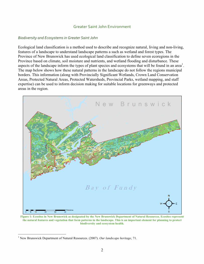
Greater Saint John Environment Biodiversity and Ecosystems in Greater Saint John Ecological land classification is a method used to describe and recognize natural, living and non-living, features of a landscape to understand landscape patterns a such as wetland and forest types. The Province of New Brunswick has used ecological land classification to define seven ecoregions in the Province based on climate, soil moisture and nutrients, and wetland flooding and disturbance. These aspects of the landscape inform the types of plant species and ecosystems that will be found in an area1. The map below shows how these natural patterns in the landscape do not follow the regions municipal borders. This information (along with Provincially Significant Wetlands, Crown Land Conservation Areas, Protected Natural Areas, Protected Watersheds, Provincial Parks, wetland mapping, and staff expertise) can be used to inform decision making for suitable locations for greenways and protected areas in the region.
Figure 1: Ecosites in New Brunswick as designated by the New Brunswick Department of Natural Resources. Ecosites represent
the natural features and vegetation that form patterns in the landscape. This is an important element for planning to protect biodiversity and ecosystem health.
1 New Brunswick Department of Natural Resources. (2007). Our landscape heritage, 71.

3
Water in Greater Saint John Water is another natural feature and resource that does not follow governance boundaries. For example, The St. John River Watershed encompasses areas of New Brunswick, Quebec, and Maine. Land use changes that affect the flow of water in one jurisdiction can have a significant impact on the quality and quantity of water in jurisdictions downstream. Changes to the natural flow of water can also result in increased flooding issues for residents if new developments do not take water impacts into account. The following image shows the contrast of natural watershed boundaries and municipal boundaries.
Figure 2: Watersheds in Greater Saint John. The natural boundaries of the watersheds do not align with municipal borders.

4
Planning around water resources will become more significant into the future in Greater Saint John due to climate change. Climate change is expected to increase extreme rainfall events and result in sea level rise, both of which will alter the historic flows of water throughout the region and pose risks to public health and safety. The following diagrams from the New Brunswick Department of Environment and Local Government show historic trends for historic sea level rise2 and extreme rainfall events3.
2 New Brunswick Department of Environment and Local Government. (2016). Extreme rainfall. 3 New Brunswick Department of Environment and Local Government. (2016). Sea level.
5
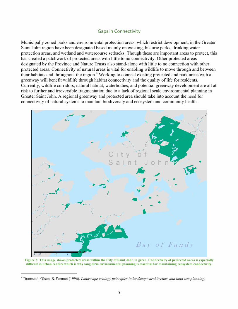
Gaps in Connectivity Municipally zoned parks and environmental protection areas, which restrict development, in the Greater Saint John region have been designated based mainly on existing, historic parks, drinking water protection areas, and wetland and watercourse setbacks. Though these are important areas to protect, this has created a patchwork of protected areas with little to no connectivity. Other protected areas designated by the Province and Nature Trusts also stand-alone with little to no connection with other protected areas. Connectivity of natural areas is vital for enabling wildlife to move through and between their habitats and throughout the region.4 Working to connect existing protected and park areas with a greenway will benefit wildlife through habitat connectivity and the quality of life for residents. Currently, wildlife corridors, natural habitat, waterbodies, and potential greenway development are all at risk to further and irreversible fragmentation due to a lack of regional scale environmental planning in Greater Saint John. A regional greenway and protected area should take into account the need for connectivity of natural systems to maintain biodiversity and ecosystem and community health.
Figure 3: This image shows protected areas within the City of Saint John in green. Connectivity of protected areas is especially difficult in urban centers which is why long term environmental planning is essential for maintaining ecosystem connectivity.
4 Dramstad, Olson, & Forman (1996). Landscape ecology principles in landscape architecture and land-use planning.

6
Greenway and Protected Area Planning “Ecological democracy is government by the people emphasizing direct, hands-on involvement. Actions
are guided by understanding natural processes and social relationships within our locality and the larger environmental context. This causes us to creatively reassess individual needs, happiness, and
long-term community goods in the places we inhabit. It offers no quick fix but rather a path for a long journey.” – Randolph T. Hester5
Greenway Benefits
Greenways serve to balance the needs of the environment and the community for the long-term sustainability of both. They provide corridors for local wildlife and help to preserve the integrity of local ecosystems that are at risk of being fragmented by human development. Fragmentation of habitats is one of the leading causes of biodiversity loss on the global scale, however, land use is managed on a local and regional scale where global trends may not be considered. Greenways and protected areas also provide health benefits for residents by providing social and recreational activities and active transportation connections between neighbourhoods and communities. Greenways and protected area planning can also help to provide regional oversight for environmental planning and land use decisions of local governments through collaboration and sharing of resources. Greenways and protected areas provide multiple benefits for communities including to residents, local governments, developers, and businesses. The following section provides a description of how greenways and protected areas have benefited other communities where they have been established. Benefits for Residents
Figure 4: bench on the Hammond River Walking Trail in Quispamsis (Image from the Town of Quispamsis6). These serene spaces help to improve peoples mental and physical health.
5 Hester, Randolph, T. (2006). Design for Ecological Democracy, p 4. 6 Town of Quispamsis. (n.d.). Hammond River Walking Trail [image].
7
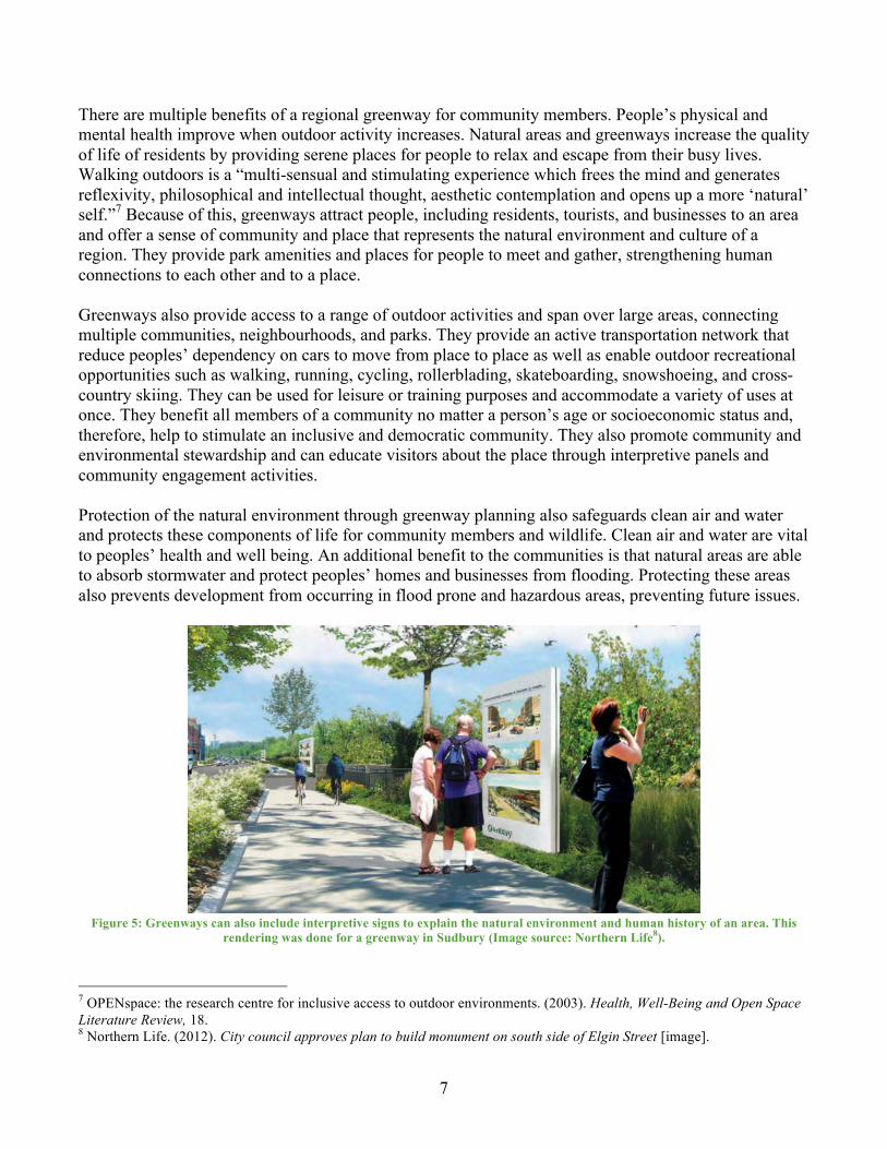
There are multiple benefits of a regional greenway for community members. People’s physical and mental health improve when outdoor activity increases. Natural areas and greenways increase the quality of life of residents by providing serene places for people to relax and escape from their busy lives. Walking outdoors is a “multi-sensual and stimulating experience which frees the mind and generates reflexivity, philosophical and intellectual thought, aesthetic contemplation and opens up a more ‘natural’ self.”7 Because of this, greenways attract people, including residents, tourists, and businesses to an area and offer a sense of community and place that represents the natural environment and culture of a region. They provide park amenities and places for people to meet and gather, strengthening human connections to each other and to a place. Greenways also provide access to a range of outdoor activities and span over large areas, connecting multiple communities, neighbourhoods, and parks. They provide an active transportation network that reduce peoples’ dependency on cars to move from place to place as well as enable outdoor recreational opportunities such as walking, running, cycling, rollerblading, skateboarding, snowshoeing, and cross-country skiing. They can be used for leisure or training purposes and accommodate a variety of uses at once. They benefit all members of a community no matter a person’s age or socioeconomic status and, therefore, help to stimulate an inclusive and democratic community. They also promote community and environmental stewardship and can educate visitors about the place through interpretive panels and community engagement activities. Protection of the natural environment through greenway planning also safeguards clean air and water and protects these components of life for community members and wildlife. Clean air and water are vital to peoples’ health and well being. An additional benefit to the communities is that natural areas are able to absorb stormwater and protect peoples’ homes and businesses from flooding. Protecting these areas also prevents development from occurring in flood prone and hazardous areas, preventing future issues.
Figure 5: Greenways can also include interpretive signs to explain the natural environment and human history of an area. This
rendering was done for a greenway in Sudbury (Image source: Northern Life8).
7 OPENspace: the research centre for inclusive access to outdoor environments. (2003). Health, Well-Being and Open Space Literature Review, 18. 8 Northern Life. (2012). City council approves plan to build monument on south side of Elgin Street [image].

8
Benefits for Local Governments Greenways benefit local governments and municipalities by protecting and enhancing green/blue infrastructure. Green/blue infrastructure are natural assets that provide free infrastructure services to the community including: diverting stormwater runoff from stormwater pipes, protecting homes and businesses from flooding, filtering stormwater from toxins and contaminants, filtering pollutants from the air, absorbing greenhouse gases such as carbon dioxide, and providing outdoor recreation assets. Conservation of natural assets also helps to lower servicing costs for local governments by concentrating development into areas that are already serviced and protecting the infrastructure services already provided by nature. Environmental protection associated with developing greenways has also been shown to increase property values for homes in adjacent neighbourhoods. Greenway designation and environmental protection will increase the overall revenue for local governments into the future by avoiding future costs for expanded services and capitalizing on natural assets to increase property values. The following graphic shows the annual municipal costs per household in Halifax, NS9 which demonstrates the economic benefits of reducing urban sprawl.
9 Sustainable Prosperity: Making Markets Work for the Environment. (2013). The cost of sprawl, a comparison.
9
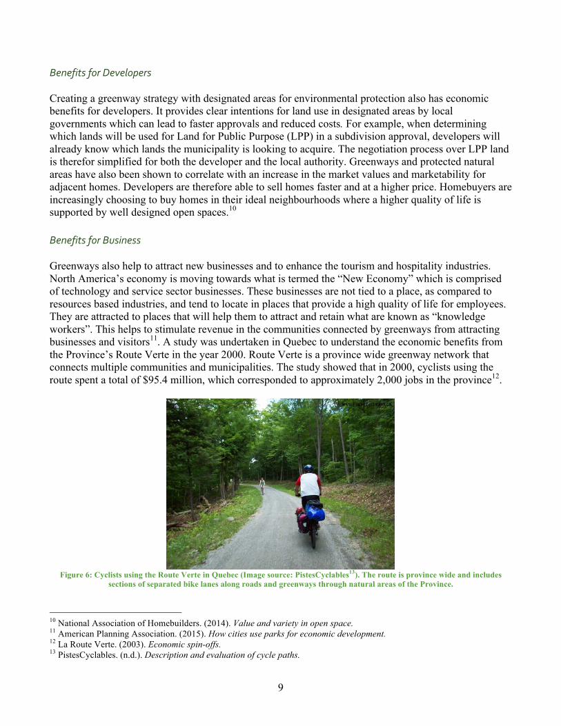
Benefits for Developers Creating a greenway strategy with designated areas for environmental protection also has economic benefits for developers. It provides clear intentions for land use in designated areas by local governments which can lead to faster approvals and reduced costs. For example, when determining which lands will be used for Land for Public Purpose (LPP) in a subdivision approval, developers will already know which lands the municipality is looking to acquire. The negotiation process over LPP land is therefor simplified for both the developer and the local authority. Greenways and protected natural areas have also been shown to correlate with an increase in the market values and marketability for adjacent homes. Developers are therefore able to sell homes faster and at a higher price. Homebuyers are increasingly choosing to buy homes in their ideal neighbourhoods where a higher quality of life is supported by well designed open spaces.10 Benefits for Business Greenways also help to attract new businesses and to enhance the tourism and hospitality industries. North America’s economy is moving towards what is termed the “New Economy” which is comprised of technology and service sector businesses. These businesses are not tied to a place, as compared to resources based industries, and tend to locate in places that provide a high quality of life for employees. They are attracted to places that will help them to attract and retain what are known as “knowledge workers”. This helps to stimulate revenue in the communities connected by greenways from attracting businesses and visitors11. A study was undertaken in Quebec to understand the economic benefits from the Province’s Route Verte in the year 2000. Route Verte is a province wide greenway network that connects multiple communities and municipalities. The study showed that in 2000, cyclists using the route spent a total of $95.4 million, which corresponded to approximately 2,000 jobs in the province12.
Figure 6: Cyclists using the Route Verte in Quebec (Image source: PistesCyclables13). The route is province wide and includes
sections of separated bike lanes along roads and greenways through natural areas of the Province.
10 National Association of Homebuilders. (2014). Value and variety in open space. 11 American Planning Association. (2015). How cities use parks for economic development. 12 La Route Verte. (2003). Economic spin-offs. 13 PistesCyclables. (n.d.). Description and evaluation of cycle paths.
10
Governance and Greenway Planning
“Sustainability is not a burden, … a sustainable city in fact can improve our quality of life.” – Bjarke Ingel14
Government of New Brunswick Strategies The following provincial strategies support the initiative of a regional greenway and environmental protection network based on Provincial goals of increasing residents’ quality of life, and protecting New Brunswick’s biodiversity, water, and wetland habitats. New Brunswick’s Wellness Strategy 2014-2021: The Heart of Our Future New Brunswick’s Wellness Strategy states that “for New Brunswickers, wellness is about feeling good, living well, being healthy and having a good quality of life15.” The goals of the strategy are to increase the number of people who have the capacity for health and wellness and to increase the settings that support wellness. The strategy recognizes that the built and natural environment have a direct effect on the health and well being of New Brunswickers. A regional greenway and protected area initiative would directly address the goal of increasing settings that support wellness by increasing inclusive recreational opportunities, providing active transportation options, and increasing peoples access to nature. Biodiversity Strategy 2009 The Biodiversity Strategy lays out the objectives for conservation of ecosystems and the sustainable use of biological resources. The strategy advocates for collaboration of organizations and governments to increase the efficiency and success of biodiversity initiatives and to increase stewardship across the province16. A regional greenway and protected area initiative aligns with the conservation and collaboration goals of this strategy and would help to protect habitat corridors that are vital for the survival of some species. Long Term Wetland Management Strategy The Wetland Management Strategy lays out the objectives for protecting and managing Provincially Significant Wetlands by the Province17. Under this strategy came amendments to the Wetland and Watercourse Alteration Regulation, within the Clean Water Act, that requires a permit to be obtained before conducting works in, and within 30 metres, of a designated wetland or watercourse18. Collaboration with the province on identifying areas for a greenway and environmental protection can help the Province with wetland protection, provide municipalities with additional help and resources for the initiative, and align environmental policies and regulations at the provincial and local level to simplify land use and development decisions.
14 Montgomery, Charles. (2013). Happy City, p 252. 15 New Brunswick Department of Social Development. (2014). New Brunswick’s Wellness Strategy 2014-2021: The Heart of Our Future, p 6. 16 New Brunswick Department of Natural Resources. (2009). Biodiversity Strategy 2009. 17 New Brunswick Department of Environment and Local Government. (2012). Long Term Wetland Management Strategy. 18 New Brunswick Department of Environment and Local Government. (2012). Chapter C-6.1 - Clean Water Act.

11
Municipal Governance Each of the municipalities of Greater Saint John have municipal plans that outline strategies for long term sustainability and that support the development of a regional scale greenway and protected areas initiative. Each of the municipalities have similar goals for environment and sustainability and place value on protecting natural areas and biodiversity, mitigating risks to the public from flooding, and increasing active transportation options. The following tables outline the municipal plans and bylaws currently in place that include strategies, measures, and regulations that apply to environmental protection and/or active transportation. These common goals can be leveraged to support a regional greenway and protected area innitiative.
Local Government Land Use Plans and By-laws
City of Saint John
Ê PlanSJ Ê ZoneSJ Ê Saint John Subdivision By-law Ê Trails and Bikeways Strategic Plan 2010 Ê PlaySJ
Town of Rothesay
Ê Rothesay Municipal Plan Ê Rothesay Zoning By-law No. 2-10 Ê Rothesay Subdivision By-law No. 4-10 Ê Rothesay Active Transportation Plan Ê Rothesay Recreation Master Plan
Town of Quispamsis
Ê Municipal Plan By-law No. 037 Ê Zoning By-law No. 038 Ê Active Transportation Plan Ê Quispamsis Trails Master Plan
Town of Grand-Bay Westfield
Ê Town of Grand Bay-Westfield Municipal Plan Bylaw Ê Town of Grand Bay-Westfield Zoning Bylaw Ê Town of Grand Bay-Westfield Subdivision Bylaw

12
Gaps in the Current Planning Process
“Today almost all major studies point to a coalescence in the next few decades of significant land degradation, population growth, water shortage, fertile soil erosion, biodiversity loss, and spread of
huge urban areas. Society is comfortable in thinking of small spaces and short times, or at best considering trends separately. When trends are connected, it is hard to miss the crisis looming… At
center stage will be land-use pattern. - Dramstad, Olson, & Forman19 Each of the municipalities in Greater Saint John include measures for environmental protection and active transportation in their strategies and by-laws; however, independent development and land use decisions can have a cumulative and overall negative impact on the environment, long-term sustainability, management of natural assets, and connectivity of habitats, green spaces, and active transportation routes at a regional scale without a coordinated effort. For example, the region has already experienced challenges in implementing the TransCanada Trail through natural areas due to complications with land ownership and lack of connectivity between green and protected areas resulting in much of the trail being developed roadside in the region. Planning for greenways now will enable trail amenities to be implemented in the future and will offer ongoing, coordinated environmental protection at the regional scale. This can also help to mitigate negative impacts from flooding in each municipality that can occur due to development decisions that don’t take cumulative stormwater runoff effects into account. Coordinating environmental oversite and knowledge has helped other regions of the country to overcome local challenges of balancing development and economic needs, public well being and security, and environmental protection to ensure long term sustainability. Establishing conservation authorities is one measure that has been implemented in many regions of North America, including in Ontario, to provide oversight on land use and development decisions of local governments for the purpose of protecting environmental assets, biodiversity, public safety, and open spaces. Currently, there is no conservation authorities in place in New Brunswick nor is there coordinated environmental oversite for local land use decisions in the Greater Saint John region. Each municipality relies mainly on internal knowledge and political will to protect the region’s natural assets when making local decisions. A regional conservation authority in Greater Saint John is one option to provide for further protection of the region’s natural assets by enabling local experts to weigh in on local land use decisions. Another planning gap for the establishment of a greenway and protected area is a lack of coordination of the environmental policies from the provincial to the local level of governance. For example, The Government of New Brunswick’s Clean Water Act requires that a Wetland and Watercourse Alteration permit must be obtained to conduct work in, and within 30 metres of, a wetland or watercourse. Local governments can reinforce this restriction within their by-laws to further enforce development restrictions in areas that are at risk to flooding, environmental damage, and cumulative impacts on water flow and water habitats through the region. Each Municipality in the Greater Saint John region approaches coordination with the province differently, some follow the provinces lead and include watercourse setbacks while others rely solely on the province to enforce wetland and watercourse protection. Municipalities can also enforce larger setbacks than the provincial regulations require for further protection of wetlands and watercourses. The Province of New Brunswick has also developed a
19 Dramstad, Olson, & Forman (1996). Landscape ecology principles in landscape architecture and land-use planning.
13
Coastal Areas Protection Policy that gives direction on protecting coastal ecosystems and the public from coastal hazards. Local governments in the Greater Saint John region have not yet applied measures from this policy in local land use plans. The following section takes a critical look at the current municipal plans and by-laws for each of the municipalities of the region. The intention is to understand the differences in how each municipality approaches environmental protection and active transportation measures within their borders. Gaps in the current plans and bylaws are highlighted where environmental sustainability could be improved upon or environmental protection and enforcement strengthened by local governments within the region.
City of Saint John
The City of Saint John places value on environmental protection, active transportation, and sustainability in PlanSJ, the Trails and Bikeways Strategic Plan, and PlaySJ. For example, PlanSJ states:
The Municipal plan aims to protect and enhance natural areas in the City to aid and improve the functioning of ecosystems and maintain biodiversity…To the maximum extent possible in an urban area, the City intends to create a balanced relationship between the functioning of urban systems and natural systems and will work with other levels of government and community partners to restore degraded natural environments20.
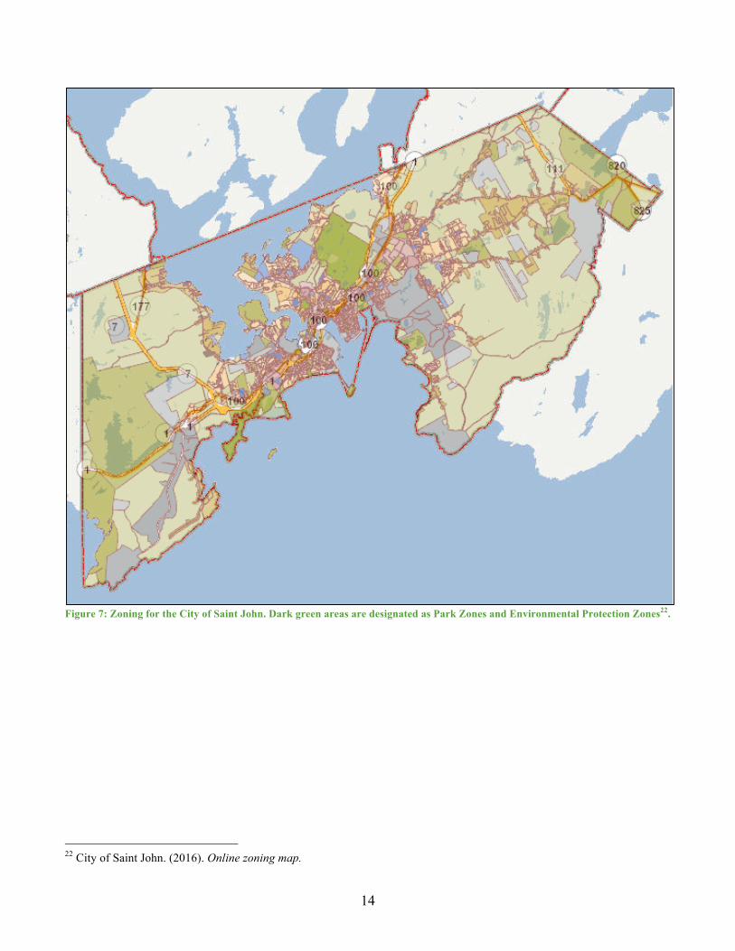
Plan SJ provides broad goals for environmental protection and sustainability but does not include actionable strategies to accomplish the goals such as defining studies that need to be conducted to fill in data gaps or timelines for action on sustainability initiatives. In addition to a lack of actionable strategies, ZoneSJ, which designates land uses and was developed in conjunction with PlanJ, does not support many of the environmental goals of PlanSJ. ZoneSJ includes two land use zones that offer environmental protection: Park and Environmental Protection21. These two zones restrict development in certain areas but have only been designated to existing parks and municipal drinking water catchment areas. Several of these areas cover large swaths of land, such as Rockwood Park and the two drinking water protection areas, which is beneficial to wildlife and the connectivity of their habitats. These zones, however, do not consider the natural environment as a widespread and connected system and offer a patchwork of environmental protection in the City.
20 City of Saint John. (2012). PlanSJ, p 155. 21 City of Saint John. (2012). ZoneSJ.
14
Figure 7: Zoning for the City of Saint John. Dark green areas are designated as Park Zones and Environmental Protection Zones22.
22 City of Saint John. (2016). Online zoning map.

15
There are also some areas with inconsistencies between PlanSJ and Zone SJ. For example, PlanSJ states that the City will:
Protect and enhance the natural flood storage capacity of flood plains by: Supporting the Marsh Creek Restoration Initiative as proposed by the Atlantic Coastal Action Program (ACAP) and the restoration of other key wetland systems in the City.23
However, when looking at the Marsh Creek Restoration Area described in PlanSJ, the zoning map includes multiple land use zones and permitted land uses under ZoneSJ such as:
• Future Development (FD) - will allow for buildings
and structures in the future once the lots are serviceable.24
• Heavy Industrial (IH) - allows for “large scale heavy industrial uses with outdoor storage and activities, and where nuisance or risk factors are expected to extend beyond the boundaries of a lot.” 25
• Corridor Commercial (CC) - allows for vehicle oriented commercial and light industrial uses along major thoroughfares. Allows for day care centres, emergency services facilities, grocery stores, medical clinics, and service stations in the floodplain.26
• Park (P) - allows for recreational uses and supporting commercial uses and also allows for community centres and day care centres to be built in the floodplain.27
Figure 8: A close-up of the zoning along Marsh Creek and the Courtenay Forebay show that a variety of uses are permitted along the watercourse under ZoneSJ
23 City of Saint John. (2012). PlanSJ, p 157. 24 City of Saint John. (2012). ZoneSJ, p 226. 25 City of Saint John. (2012). ZoneSJ, p 191. 26 City of Saint John. (2012). ZoneSJ, p 157 - 160. 27 City of Saint John. (2012). ZoneSJ, p 221.

16
PlanSJ was approved by council in 2012 and will be up for review in 2017. The review of Saint John’s municipal plan and zoning bylaw offers an opportunity to build upon the broad goals of PlanSJ for environmental protection, sustainability, and improving the quality of life for residents. The city can include actionable strategies with timelines for action to ensure that these goals are accomplished moving forward and align these strategies with the zoning bylaw. The City can also enforce wetland and watercourse setbacks within the City’s by-laws to reinforce provincial policies for water protection. The City of Saint John could also use its subdivision-bylaw to ensure that new subdivisions maintain the environmental and sustainability goals of PlanSJ. Subdivision by-laws have been used by many municipalities to designate the type of land to be acquired through Land for Public Purpose (LPP) and to enforce design standards that minimize infrastructure costs for the municipality, protect environmental assets considered valuable for the community, and minimize the risk of flooding.
Town of Rothesay The Town of Rothesay lists seven principles for sustainable community planning in Rothesay’s municipal plan to guide development and land use decisions. The principles are listed as to:
§ Promote pedestrian movement opportunities; § Foster efficient land development; § Promote water conservation; § Promote waste reduction; § Promote energy efficiency; § Minimize environmental impact; and § Foster public engagement.28
The municipal plan also states two goals related to environmental protection: to sustain, or where possible to enhance, the quality of the environment within Rothesay related to development and human activity; and, to protect areas of significant scenic, environmental and wildlife habitat as they are identified.29 The Town’s subsequent regulations designated by the Rothesay Zoning By-law, Rothesay Subdivision By-law No., Rothesay Active Transportation Plan, and Rothesay Recreation Master Plan help to support the principles for sustainability planning and goals listed in the Town’s municipal plan. For example, the Town’s zoning bylaw includes measures to enable the planning advisory committee to deny building permits for sites that are marshy, prone to flooding, steep, or unsuitable due to environmental conditions30. This enables local environmental oversite over individual land use decisions. The zoning bylaw also includes Stormwater Management Guidelines that apply to all developments and require that mature trees, natural vegetation, and topography be retained wherever possible and that impervious surfaces be minimized31. Flood risk mitigation is also included by requiring living spaces to be at least 28 Town of Rothesay. (2010). Rothesay Municipal Plan, p 2. 29 Town of Rothesay. (2010). Rothesay Municipal Plan, p 4. 30 Town of Rothesay. (2010). Rothesay Zoning By-law No. 2-10, p 4. 31 Town of Rothesay. (2010). Rothesay Zoning By-law No. 2-10, p 62.
17
6.5 metres above sea level in flood risk areas32, this does not however take into account the affects that building in a flood risk area may have on neighbouring properties. The zoning by-law also reinforces the New Brunswick Clean Water Act by restricting development within 30 metres of a watercourse or waterbody33 offering further protection of water quality, quantity, and habitat. The Rothesay Subdivision By-law includes measures that enable the Town to acquire Land for Public Purpose (LPP) or cash in lieu of LPP34. The Town does not, however, have a land acquisition strategy that defines which lands would be suitable to acquire for LPP. Defining areas to be acquired for LPP can help to speed up the subdivision process by simplifying negotiations with developers over LPP land. The Rothesay Active Transportation Plan outlines an objective to develop a coordinated network with Saint John and Quispamsis and states that communication with Quispamsis has already begun35. The Town of Rothesay does not currently have a network of multi use, natural trails to enable active transportation through natural areas but has shown initiative to develop a regional active transportation network. Rothesay also has a number of environmental concerns along the municipal boundary. Flooding issues for residents in Oakville Acres in Rothesay where increased due to adjacent developments in both Rothesay and Quispamsis. The issue has since been remediated with the Oakville Acres detention project that helps to capture the runoff from the developed area before it enters the Oakville Acres neighbourhood. The cumulative affects of multiple developments in both municipalities resulted in this flooding issue. Coordinated environmental oversite and planning could have mitigated the risk of flooding in this area from developments upstream. Furthermore, Carpenters Pond is divided by the boundary between the Town of Rothesay and City of Saint John. Neither municipality has control over how the other manages the land within and adjacent to the waterbody and a collaborative agreement could prevent any issues form arising. This is another area where a coordinated initiative for environmental protection can prevent negative environmental impacts from the decisions of one municipality on neighbouring municipalities.
32 Town of Rothesay. (2010). Rothesay Zoning By-law No. 2-10, p 63. 33 Ibid. 34 Town of Rothesay. (2010). Rothesay Subdivision By-law No. 4-10. 35 Town of Rothesay. (2010). Rothesay Active Transportation Plan.

18
Figure 9: Zoning Map for the Town of Rothesay. Green areas are zoned as Recreational and include town parks and development
restrictions. They provide for a patchwork of environmental protection within the Town’s borders that could lead to fragmentation of habitats as the Town grows.

19
Town of Quispamsis The Town of Quispamsis includes in its municipal plan the objective to “to provide a pleasant and safe living and working environment in accordance with sustainable development principles36.” The plan also includes policies and objectives to: ensure that new developments are cost effective and environmentally sound, provide recreational services for residents, promote active transportation trails, protect areas designated as open spaces on the Future Land Use Map, and collaborate with other municipalities to promote regional tourism initiatives37. Policies in the plan which aim to protect the environment include: to “preserve and enhance the natural and built environment” and “preserve and enhance river banks, beaches, watercourses, wetlands and important habitat for flora and fauna”. These policies give direction on planning decisions but are fairly broad as far as implementing initiatives or carrying out actions. More specifically, one policy states that activities within or near a wetland or watercourse will be subject to provincial Wetland and Watercourse Alteration Program which does have a direct impact on the Town’s zoning by-law and development decisions. Another environmental policy in the plan includes to develop watershed and wellfield protection plans; a Hammond River Watershed Management Plan was developed in partnership with the Hammond River Angling Association, University of New Brunswick, and the Environmental Trust Fund. This watershed plan provides scientific information about the natural environment within the watershed and can be used to inform land use strategies, zoning, and development decisions. Under the Town’s Zoning By-law developers must get approval from the Planning Advisory Committee to develop within 30 metres of a stream or watercourse as well as the provincial approvals through a Wetland and Watercourse Alteration permit38. The Town’s zoning by-law also requires that new developments maintain existing trees were possible and that trees removed for new developments be replaced to enhance the appearance of the lot39. This has the added benefit of preserving habitat where possible on developed lots and ensuring that tree habitat within the Town is maintained over time. Within the Town’s zoning by-law, there are two zones to provide for open space and environmental protection. The first is a Park Zone that restricts development for the use of recreational services such as parks, golf courses, playgrounds, and public open space40. It focuses on preserving human use of these areas rather than environmental protection. Another zone, Conservation Area, acts as an overlay zone for some parcels which means that some parcels have two zoning designations. For these parcels, the permitted uses of the original zone are still permitted but the development must comply with any environmental restrictions imposed by the province. Other parcels are designated as only Conservation Area zones; these areas are protected for natural or scientific interest, the protection of environmentally sensitive areas, and parks41. The Conservation Area overlay zoning helps to connect designated Conservation Areas and minimize habitat fragmentation. The policies and Conservation Area zone in Quispamsis’ zoning by-law reinforce and support provincial policy for protecting watercourses under the Clean Water Act providing for increased and coordinated enforcement for environmental protection.
36 Town of Quispamsis. (2013). Municipal Plan By-law No. 037, p 37. 37 Town of Quispamsis. (2013). Municipal Plan By-law No. 037, p 13-28. 38 Town of Quispamsis. (2013). Zoning By-law No. 038, p 24 & 43. 39 Town of Quispamsis. (2013). Zoning By-law No. 038, p 39. 40 Town of Quispamsis. (2013). Zoning By-law No. 038, p 81. 41 Town of Quispamsis. (2013). Zoning By-law No. 038, p 82.

20
The Quispamsis Subdivision by-law further enhances environmental protection in the municipality. The by-law enables the municipality to acquire Land for Public Purpose (LPP) when a lot is being subdivided and enables the Planning Advisory Committee to recommend the lands to be acquired. A list of suitable area types for LLP is included in the by-law and includes: areas designated as open space on the Future Land Use Map, conservation or watercourse areas, access to waterbodies, greenbelt or buffer areas, wooded and slopes areas with vistas, and pedestrian ways42. These suggestions provide direction on designating LPP land and negotiating subdivisions with developers. The LPP process could be given further direction by mapping out desired areas for LPP in a land acquisition strategy. The subdivision by-law also reinforces and mimics the requirements for removing the minimal amount of trees necessary for development from the Town’s zoning by-law. Quispamsis also has a Trails Master Plan and Active Transportation Plan that aim to preserve the opportunity to have a comprehensive trail network within the municipality and that connects with neighbouring communities. The Trails Master Plan also provides direction on acquiring Land for Public Purpose during the subdivision process43.
Figure 10: Town of Quispamsis Zoning Map. Teal areas are designated as Conservation Areas (CR) and dark green areas are
designated as Park/Recreation (PR).
42 Town of Quispamsis. (n.d.). Subdivision By-law No. 035, p 10. 43 Town of Quispamsis. (n.d.). Trails Master Plan, p 1.

21
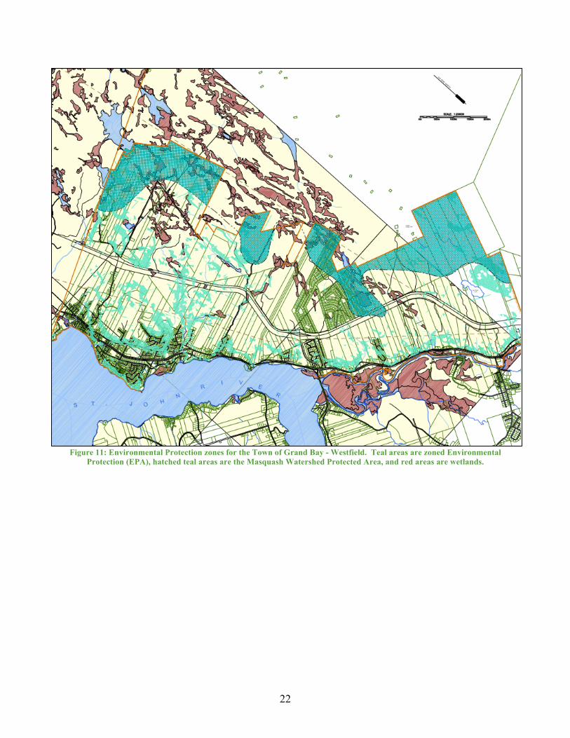
Town of Grand Bay – Westfield The Town of Grand Bay - Westfield aims to improve environmental protection within the Town. The Town’s municipal plan contains four “policies related to topographical limitations, water quality protection and future municipal water services, storm-water control and sanitary sewer services to protect drinking water sources. The strategies all focus on prevention and avoidance of environmental conflicts and support certain provincial initiatives in this regard. For example, policies to control development near waterways or steep slopes, a future possibility of sewer extensions, and the introduction of wetlands mapping has been initiated by the Town44.” The municipal plan specifies that impacts on natural habitats and groundwater, public safety, and pollution of air, soil, and water will be considered for all amendments to the zoning by-law. The plan also describes how the Town will continue to develop the Heritage Trail and a trail loop that connects park nodes and centres of activity and has a policy to work with other agencies to promote provincial and regional trails. The Town identifies partners and specific areas for developing trails and protected areas within its municipal plan such as partnering with the Nature Trust of New Brunswick to manage Blueberry Hill45. The Town of Grand Bay – Westfield has two zones that offer environmental protection: Park/Green Space and Environmental Protection. The environmental Protection zone was designated to areas where the slope is 15% or greater and poses an erosion risk, major waterways, wetlands, and the Musquash Watershed. The Park/Green Space zone is designated to public parks, open spaces, and playgrounds. The zoning by-law also specifies that permission from the Planning Advisory Committee, as well as the Province, must be obtained before building a structure within 30 metres of a wetland or watercourse46. This helps to strengthen environmental protection by coordinating the requirements at the Provincial and local level of governance. Overall, the Town of Grand Bay – Westfield has many environmental protection measures in place. A regional greenway and protected area can help to strengthen the resolve of these initiatives for environmental protection and expand the Town’s trails and protected areas into neighbouring municipalities.
44 Town of Grand Bay – Westfield. (2009). Town of Grand Bay – Westfield Municipal Plan, section 2.2. 45 Town of Grand Bay – Westfield. (2009). Town of Grand Bay – Westfield Municipal Plan, section 3.1.6. 46 Town of Grand Bay – Westfield. (2009). Town of Grand Bay – Westfield Zoning By-law, section 2.7.
22
Figure 11: Environmental Protection zones for the Town of Grand Bay - Westfield. Teal areas are zoned Environmental
Protection (EPA), hatched teal areas are the Masquash Watershed Protected Area, and red areas are wetlands.

23
Greenway Planning Steps In order to begin the process of regional environmental protection planning and greenway development, Greater Saint John municipalities can work together towards implementing a regional greenway and protected area network and include further environmental planning initiatives within their borders. The following list provides suggestions of actionable items that each municipality can undertake to help in implementing a regional greenway and environmental network:
• Form an environmental committee to oversee environmental initiatives for the region; • Form a conservation authority to provide environmental oversight on land use decisions; • Include actionable initiative and timelines for completion in municipal plans during plan
reviews; • Develop a greenway and protected area plan for environmental protection and active
transportation in partnership with neighbouring municipalities; • Include a regional greenway network into future land use maps; • Update and develop municipal Integrated Community Sustainability Plans; • Update municipal trails, bikeways, and recreational plans to include strategies for developing a
regional greenway and protected area network; • Develop municipal climate change action plans to address environmental impacts such as
flooding and erosion; • Develop regional or local open space and land acquisition strategies and maps, including Land
for Public Purpose acquisition strategies, that contribute to environmental protection and active transportation opportunities;
• Conduct studies, and partner with academia and local organizations on studies, of local biodiversity, local climate change impacts, and active transportation opportunities;
• Include existing information from local watershed plans into municipal plans and by-laws; • Implement a service fee for stormwater runoff and impervious surfaces to provide financing for
the maintenance of stormwater infrastructure and an incentive to minimize building and parking lot footprints (this has recently been implemented in Mississauga, Ontario in 201647);
• Engage with the public over locations and amenities desired for a regional greenway network (a public opinion survey is included in the Appendix of this report); or
• Create educational materials and workshops to educate decision makers, businesses, developers, and the public about environmental concerns and greenway opportunities.
47 City of Mississauga. (2016). Stormwater charge. http://www.mississauga.ca/portal/stormwater/charge
24
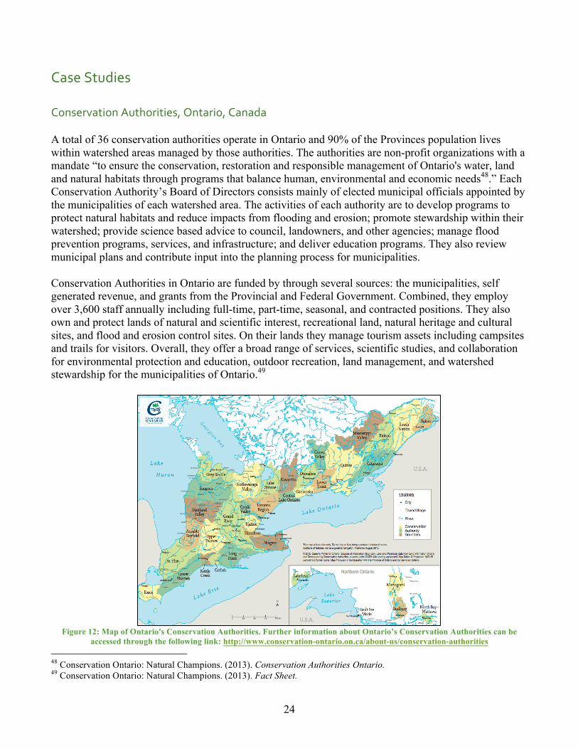
Case Studies Conservation Authorities, Ontario, Canada A total of 36 conservation authorities operate in Ontario and 90% of the Provinces population lives within watershed areas managed by those authorities. The authorities are non-profit organizations with a mandate “to ensure the conservation, restoration and responsible management of Ontario's water, land and natural habitats through programs that balance human, environmental and economic needs48.” Each Conservation Authority’s Board of Directors consists mainly of elected municipal officials appointed by the municipalities of each watershed area. The activities of each authority are to develop programs to protect natural habitats and reduce impacts from flooding and erosion; promote stewardship within their watershed; provide science based advice to council, landowners, and other agencies; manage flood prevention programs, services, and infrastructure; and deliver education programs. They also review municipal plans and contribute input into the planning process for municipalities. Conservation Authorities in Ontario are funded by through several sources: the municipalities, self generated revenue, and grants from the Provincial and Federal Government. Combined, they employ over 3,600 staff annually including full-time, part-time, seasonal, and contracted positions. They also own and protect lands of natural and scientific interest, recreational land, natural heritage and cultural sites, and flood and erosion control sites. On their lands they manage tourism assets including campsites and trails for visitors. Overall, they offer a broad range of services, scientific studies, and collaboration for environmental protection and education, outdoor recreation, land management, and watershed stewardship for the municipalities of Ontario.49
Figure 12: Map of Ontario's Conservation Authorities. Further information about Ontario’s Conservation Authorities can be
accessed through the following link: http://www.conservation-ontario.on.ca/about-us/conservation-authorities 48 Conservation Ontario: Natural Champions. (2013). Conservation Authorities Ontario. 49 Conservation Ontario: Natural Champions. (2013). Fact Sheet.

25
Capital Regional District Regional Green/Blue Spaces Strategy (and Land Acquisition Fund), British Columbia, Canada The Capital Regional District, a regional government for 13 municipalities and three electoral areas, developed a Green/Blue Space Strategy in 1997. The strategy was developed in partnership with the Provincial Capital Commission, a Crown Agency which has since been dissolved. The Capital Regional District acts as a coordinator to encourage inter-municipal committees and formed a public advisory committee. The Green/Blue Spaces Strategy does not regulate development within municipalities; it provides information and recommendations for regulation. Each municipality chooses how to protect green and blue spaces within their jurisdictions based one their local context. The greenways and conservation areas identified in the plan represent a best case scenario and broad vision of areas that should be protected. The strategy outlines why green and blue space should be protected, which regionally significant areas should be protected, who can contribute, and how protection can be achieved. The strategy contains four types of areas for conservation. The first type is green/blue space core areas and includes existing parks, valuable unprotected green and blue spaces, and water supply lands. The second area type is greenway that includes areas that link green and blue spaces, streams and wetlands (called blueways), and greenways that enable public access to the coast. The third area type is renewable resource working landscapes that includes agricultural and managed forest land. The fourth area type is valuable remnant ecosystems. These are sensitive environmental lands that are not yet included in the green/blue space core areas. The protection areas included in the strategy were nominated by municipalities, the public, and the Island Trust (a conservation land trust). The following criteria were used to assess the value of nominated conservation areas: ecological, scenic, renewable resource working landscapes, outdoor recreation, and greenways. The strategy recognizes that many stakeholders must be involved in the process of conserving green and blue space in the region. It states that implementation of the strategy is not the responsibility of one agency, implementation depends on collaboration between multiple agencies. The strategy outlines specific actions for each of the following stakeholders: citizens, landowners, non-profit organizations, institutions and public utilities, first nations, municipalities, land trusts, the Capital Regional District, the Provincial Capital Commission, the Government of BC, and the Government of Canada. The Capital Regional District also created a land acquisition fund in 2000 to contribute to acquiring lands identified in the Green/Blue Space Strategy.50 The Green/Blue Spaces Strategy can be found through the following link: https://www.crd.bc.ca/docs/default-source/parks-pdf/greenblue_spaces_strategy.pdf?sfvrsn=0
50 Capital Regional District Parks. (1997). Regional blue/green spaces strategy.

26
Conclusion This document describes the benefits that a greenway and protected area initiative in Greater Saint John would provide for the people and environment of the region. Greenways have been shown to improve the quality of life for residents from all backgrounds and abilities by providing access to nature and free recreational opportunities. They have also been shown to provide economic benefits to municipalities through increased property taxes and business development. Developers also benefit by increased marketability of developments and simplification of Land for Public Purpose negotiations. The environment also benefits from greenways because they promote environmental stewardship, connect protected areas, and are designated by taking habitats and water flow into consideration. This report also describes current land use planning practices by the Municipalities of the region of Greater Saint John and how they each differ in their approach to environmental planning, recreation, and trail development. A regional trail system has been acknowledged by each of the municipalities to provide recreational assets for the region. Environmental protection, however, varies greatly between borders with each municipality taking a different approach. For example, the towns of Quispamsis and Grand Bay –Westfield each include watercourse buffers in their zoning maps and require permission a the local and provincial levels of governance for activities within 30 metres of wetlands and watercourses; in contrast, the City of Saint John relies entirely on the provincial government to implement and enforce setbacks. There are multiple case studies that can be explored, such as the green/blue network in British Columbia, that demonstrate the benefits of greenways and protected areas. A collaborative approach to greenway and protected area planning has been shown to benefit regions as a whole by sharing environmental knowledge and resources between local governments and developing consistent policies and objectives for environmental protection in the region. A greenway through protected areas will help to gain public support for environmental protection, promote environmental stewardship and education opportunities, increase the well being of residents, benefit the regional economy, and increase tourism. It will provide have long-term benefits for the regions environment, society, and economy.

27
References American Planning Association. (2015). How cities use parks for economic development.
Retrieved from https://www.planning.org/cityparks/briefingpapers/ economicdevelopment.htm
Capital Regional District Parks. (1997). Regional blue/green spaces strategy. Retrieved from https://www.crd.bc.ca/docs/default-source/parks-pdf/greenblue_spaces_strategy.pdf?sfvrsn=0 City of Saint John. (2010). City of Saint John trails and bikeway strategic plan. Retrieved from http://www.saintjohn.ca/site/media/SaintJohn/bike-trails-plan(1).pdf City of Saint John. (2012). PlanSJ. Retrieved from http://www.saintjohn.ca/site/media/SaintJohn/ Municipal%20Plan%20for%20web%202012-01-12.pdf City of Saint John. (2012). ZoneSJ. http://www.saintjohn.ca/site/media/SaintJohn/The%20City%20of% 20Saint%20John%20Zoning%20By-law%202014.pdf City of Saint John. (2012). PlaySJ: Parks and recreation strategic plan. Retrieved from http://www.saintjohn.ca/site/media/SaintJohn/PLAYSJ%20Mast%20Plan%20Draft.pdf Conservation Ontario: Natural Champions. (2013). Conservation Authorities of Ontario. Retrieved from http://www.conservation-ontario.on.ca/about-us/conservation-authorities Conservation Ontario: Natural Champions. (2015). Fact Sheet. Retrieved from http://www.conservation- ontario.on.ca/media/CO_Fact_Sheet.pdf Dramstad, W.E., Olson, J.D., & Forman, R.T.T. (1996). Landscape ecology principles in
landscape architecture and land-use planning. Harvard University Graduate School of Design, Island Press, & American Society of Landscape Architecture. Island Press: Washington.
Hester, Randolph, T. (2006). Design for Ecological Democracy. Cambridge: Massachusetts Institute of
Technology.
La Route Verte. (2003). Economic spin-offs. Retrieved from http://www.routeverte.com/e/retombees_e Montegomery, Charles. (2013). Happy City. Canada: Penguin Random House, Anchor Canada. National Association of Homebuilders. (2014). Value and variety in open space. Retrieved from
https://www.nahb.org/en/research/~/media/61CA9D440A0B48AF80900F2063FBECE9.ashx New Brunswick Department of Environment and Local Government. (2012). Chapter C-6.1 - Clean
Water Act. Retrieved from http://www.canlii.org/en/nb/laws/stat/snb-1989-c-c-6.1/latest/snb-1989-c-c-6.1.html

28
New Brunswick Department of Environment and Local Government. (2012). Long Term Wetland Management Strategy. Retrieved from http://www2.gnb.ca/content/dam/gnb/Departments/ env/pdf/WetlandStrategyStrategieTerresHumides.pdf
New Brunswick Department of Environment and Local Government. (2016). Extreme rainfall. Retrieved from http://www2.gnb.ca/content/gnb/en/departments/elg/environment/content/ climate_change/content/climate_change_indicators/indicators/climate/extreme_rainfall.html New Brunswick Department of Environment and Local Government. (2016). Sea level. Retrieved from http://www2.gnb.ca/content/gnb/en/departments/elg/environment/content/climate_change/conten t/climate_change_indicators/indicators/water/sea_level.html New Brunswick Department of Natural Resources. (2007). Our landscape heritage. Retrieved
from http://www2.gnb.ca/content/dam/gnb/Departments/nr-rn/pdf/en/ ForestsCrownLands/ProtectedNaturalAreas/OurLandscapeHeritage/Chapter10-e.pdf
New Brunswick Department of Natural Resources. (2009). Biodiversity Strategy 2009. Retrieved from
http://www2.gnb.ca/content/dam/gnb/Departments/nr-rn/pdf/en/ForestsCrownLands/Biodiversity.pdf
New Brunswick Department of Social Development. (2014). New Brunswick’s Wellness Strategy 2014-
2021: The Heart of Our Future. Retrieved from http://www2.gnb.ca/content/dam/gnb/ Departments/sd-ds/pdf/Wellness-MieuxEtre/NewBrunswickWellnessStrategy2014-2021.pdf
Northern Life. (2012). City council approves plan to build monument on south side of Elgin Street
[image]. Retrieved from http://www.northernlife.ca/news/localNews/2012/10/17-rock-of-fame-sudbury.aspx
OPENspace: the research centre for inclusive access to outdoor environments. (2003). Health, well-
being and open space literature review. Edinburgh College of Art and Heriot-Watt University. Retrieved from http://www.openspace.eca.ed.ac.uk/pdf/appendixf/OPENspacewebsite_ APPENDIX_F_resource_31.pdf
PistesCyclables. (n.d.). Description and evaluation of cycle paths. Retrieved from http://pistescyclables.ca/Evaluation/Evaluation.htm Sustainable Prosperity: Making Markets Work for the Environment. (2013). The cost of sprawl, a
comparison. Retrieved from http://usa.streetsblog.org/wp-content/uploads/sites/5/2015/03/sprawlurban.jpg
Town of Grand Bay-Westfield. (2009). Town of Grand Bay-Westfield Municipal Plan Bylaw. Retrieved from http://www.town.grandbay-westfield.nb.ca/municipal-office/by-laws/by-law-no-111/ Town of Grand Bay-Westfield. (2009). Town of Grand Bay-Westfield Zoning Bylaw. Retrieved from http://www.town.grandbay-westfield.nb.ca/municipal-office/by-laws/by-law-no-112/

29
Town of Grand Bay-Westfield. (2009). Town of Grand Bay-Westfield Subdivision Bylaw. Retrieved from http://www.town.grandbay-westfield.nb.ca/wp-content/uploads/2014/02/GBW- Subdivision-Bylaw.pdf Town of Quispamsis. (2013). Municipal Plan By-law No. 037. Retrieved from http://quispamsis.ca/wp- content/uploads/2014/12/037Bylaw-Municipal-Plan-with-AMD-6.pdf Town of Quispamsis. (2013). Zoning By-law No. 038. Retrieved from http://quispamsis.ca/wp- content/uploads/2014/12/038Bylaw_Zoning_with_AMD_19.pdf Town of Quispamsis. (n.d.). Quispamsis Trails Master Plan. Retrieved from http://quispamsis.ca/active- living/trails/ Town of Quispamsis. (n.d.). Hammond River Walking Trail [image]. Retrieved from
http://quispamsis.ca/active-living/trails/hammond-river-walking-trails/ Town of Rothesay. (2010). Rothesay Municipal Plan. Retrieved from http://www.rothesay.ca/assets/Uploads/PDFS/By-law1-10.pdf Town of Rothesay. (2010). Rothesay Zoning By-law No. 2-10. Retrieved from http://www.rothesay.ca/assets/Uploads/Bylaws/2-10-Zoning.pdf Town of Rothesay. (2010). Rothesay Subdivision By-law No. 4-10. Retrieved from http://www.rothesay.ca/assets/Uploads/Bylaws/4-10-Subdivision-BylawFINAL.pdf Town of Rothesay. (2010). Rothesay Active Transportation Plan. Retrieved from http://www.rothesay.ca/assets/Uploads/Active-Transportation-Plan-2012/Draft-Report-Rothesay- AT-Plan20121101.pdf

30
Appendix Public Opinion Survey The following survey was developed by ACAP Saint John to gauge and gain public support for a regional greenway protected areas network. This survey is intended to assess public interest for a regional trail and unified environmental protection area in Greater Saint John. For the purposes of this survey, Greater Saint John includes the City of Saint John, Town of Rothesay, Town of Quispamsis, Town of Grand Bay-Westfield, and surrounding parishes.
1. Which community do you live in? Ê City of Saint John Ê Town of Rothesay Ê Town of Quispamsis Ê Town of Grand Bay-Westfield Ê Other (please specify): _____________
The following section asks for your personal opinion about the environment in Greater Saint John.
2. A clean environment is important for my quality of life in Greater Saint John. Ê Strongly Agree Ê Agree Ê Somewhat Agree Ê Undecided Ê Somewhat Disagree Ê Disagree Ê Strongly Disagree
3. Access to natural areas is important to my quality of life in Greater Saint John.
Ê Strongly Agree Ê Agree Ê Somewhat Agree Ê Undecided Ê Somewhat Disagree Ê Disagree Ê Strongly Disagree

31
4. We need to protect our waterways and fish habitats in Greater Saint John. Ê Strongly Agree Ê Agree Ê Somewhat Agree Ê Undecided Ê Somewhat Disagree Ê Disagree Ê Strongly Disagree
5. We need to protect our forest habitats and wildlife in Greater Saint John.
Ê Strongly Agree Ê Agree Ê Somewhat Agree Ê Undecided Ê Somewhat Disagree Ê Disagree Ê Strongly Disagree
6. The natural environment of Greater Saint John is already well protected.
Ê Strongly Agree Ê Agree Ê Somewhat Agree Ê Undecided Ê Somewhat Disagree Ê Disagree Ê Strongly Disagree
7. Do you have any comments about Greater Saint John’s natural environment?
__________________________________________
Greenways Greenways are regional trail systems that link multiple communities through undeveloped areas set aside for environmental protection and recreation.
1. Do you support the notion of a regional greenway for Greater Saint John? Ê Yes Ê No Ê Not Sure
(comment: ______________________)
32
2. For which activities would you use a greenway in Greater Saint John? (check all that apply)
Ê Commuting between home and work/school Ê Personal trips to shopping areas, community centres, tourist destinations, and/or
other neighbourhoods Ê Leisure and recreation (including access to parks, recreational facilities, and
waterways) Ê Fitness and training Ê Promoting your business or developing a new business Ê Other (please specify):
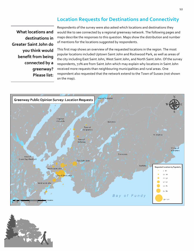
3. What locations and destinations in Greater Saint John do you think would benefit from being
connected by a greenway? Please list: _________________________________________________________________
4. Which modes of transportation would you use on a greenway?
(check all that apply) Ê Walking/hiking/running Ê Cycling Ê Rollerblading/skateboarding Ê Canoeing/kayaking (if connected to waterbodies) Ê ATVing Ê Cross country skiing/snowshoeing Ê Skating Ê Snowmobiling Ê Other (please specify):
5. Would you walk, jog, and/or cycle more if a greenway was built in Greater Saint John?
Ê Yes Ê No Ê Not sure
6. Would you use a greenway in the winter if it were maintained for winter activities such as skiing,
snowshoeing, or skating? Ê Yes Ê No Ê Not sure

33
7. What features for a greenway would be most important for you? Rank from 1 - most important to 5 - least important.
Ê Greenway Experience (access to natural areas, scenic views) Ê Traffic Safety (separated from vehicle traffic, limited road crossings) Ê Safety (well lit, clean, maintained) Ê Connectivity (to schools, shopping areas, downtowns/main streets, transit and/or
ferries) Ê Comfort (flat trails, limited hills, paved vs. gravel)
8. What greenway facilities are important to you? Rank from 1 – most important to 8 – least
important. Ê Vehicle parking at access points Ê Benches/picnic tables Ê Shelters Ê Lookouts Ê Interpretive panels and information about greenway areas Ê Bike racks and repair stands Ê Bike rental Ê Kayak/canoe rental
9. Are there additional greenway facilities, not included in question 8, that are important to you? If
yes, please list: (Optional) _______________________________________________________________
10. What name would you give to a regional greenway for Greater Saint John? (Optional)
_______________________________________________________________
11. Do you have any further comments about a regional greenway in Greater Saint John? (Optional) _______________________________________________________________

34
ACAP Saint John is a non-profit charitable environmental organization that was formed in 1992. Our mission is to engage the multi-sectorial community of Greater Saint John in the collaborative
management and restoration of our watersheds. ACAP Saint John works with those stakeholders in the community who share a common belief that an industrialized urban center can support an abundance of
functional natural capital. ACAP Saint John envisions a sustainable community that embraces the interdependence of the unique social, economic, and environmental characteristics of the region’s
watersheds.
Atlantic Coastal Action Program (ACAP) Saint John
76 Germain Street, PO Box 6878 Stn A Saint John, New Brunswick, E2L 4S3
Phone: 506.652.2227
Fax: 506.633.2184 E-mail: [email protected] Website: www.acapsj.org
The Without Borders Public Opinion Survey was used to gauge public
support for environmental protection and a regional greenway in
Greater Saint John.
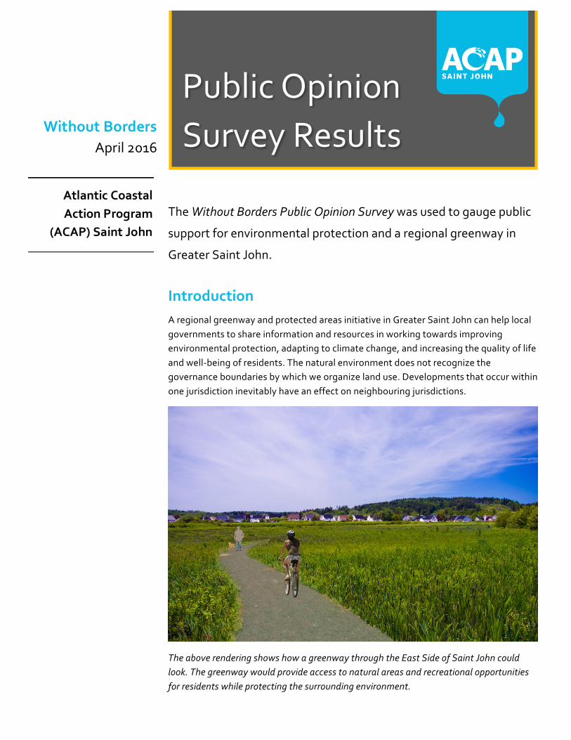
Introduction A regional greenway and protected areas initiative in Greater Saint John can help local governments to share information and resources in working towards improving environmental protection, adapting to climate change, and increasing the quality of life and well-being of residents. The natural environment does not recognize the governance boundaries by which we organize land use. Developments that occur within one jurisdiction inevitably have an effect on neighbouring jurisdictions.
The above rendering shows how a greenway through the East Side of Saint John could look. The greenway would provide access to natural areas and recreational opportunities for residents while protecting the surrounding environment.
Public Opinion Survey Results Without Borders
April 2016
Atlantic Coastal Action Program
(ACAP) Saint John

2
The Greenway Public Opinion Survey was posted on ACAP Saint John’s webpage from March 4th to March 25th and advertised through social media from March 4th to March 22nd. The survey was completed by 760 respondents whom live mainly in the Greater Saint John Region. A few former residents and returning residents also completed the survey.
Other:
• Town of Hampton, NB • Willow Grove, NB • Kingston Peninsula, NB
• Darlings Island, NB • Summerville, NB • Upper Golden Grove, NB • Bocabec, NB • Lorneville, NB • Welsford, NB • St Andrews, NB • Grove Hill, NB
• Baxters Corner, NB
• Musquash, NB • St George, NB • Nauwigewauk, NB
• Springfield, NB • Blacks Harbour, NB • Greenwood, NS • Lakeside, NB • Maces Bay, NB • Calgary, AB • Halifax, NS • Moncton, NB
Where do you live?
3
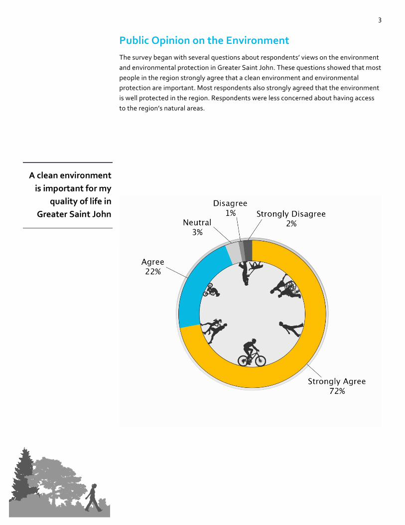
Public Opinion on the Environment The survey began with several questions about respondents’ views on the environment and environmental protection in Greater Saint John. These questions showed that most people in the region strongly agree that a clean environment and environmental protection are important. Most respondents also strongly agreed that the environment is well protected in the region. Respondents were less concerned about having access to the region’s natural areas.
A clean environment is important for my
quality of life in Greater Saint John

4
Access to natural areas is important to
my quality of life in Greater Saint John
Protecting natural areas for the benefit of fish and wildlife in Greater Saint John is
important to me

5
When asked about the natural environment of Greater Saint John, 178 respondents commented. The following categories were created based on comments from this question and are listed from the most to least common:
• The environment in Greater Saint John needs further protection (55)
• There are natural assets in Greater Saint John (50) • Improved access to natural areas and waterfronts is needed (32) • Attribute industry to harming the natural environment of Greater Saint John
(31)
• Bike and pedestrian routes need to be improved (20) • Economic development is valued higher than the environment in Greater Saint
John (13)
• There have been notable improvements to the environment in Greater Saint John (12)
• There needs to be a balance between industry and development and the environment (8)
• Hazards of flooding and erosion are issues in Greater Saint John (4) • The natural environment is protected in Greater Saint John (2) • Concern over negative economic impacts and tax increases from implementing
a greenway (2)
I think the natural environment of
Greater Saint John is well protected
Do you have any comments about
Greater Saint John’s natural environment?

6
Public Opinion on a Regional Greenway Network
Respondents showed tremendous support for a regional greenway in Greater Saint John with 94% answering yes when directly asked if they support this idea. An open comments section at the end of the survey also highlighted a positive overall response for a regional greenway. Of 115 comments, 72 showed enthusiasm for wanting a greenway to be developed for the region.
Do you support the notion of a regional greenway network
for Greater Saint John?

7
Most respondents indicated that a regional greenway would increase their personal activity levels. An increase in physical activity can help to tackle the obesity epidemic in New Brunswick. According to the New Brunswick Health Indicators, 60.4% of adults in the Saint John area and 29.2% of children and youth aged 12-18 are overweight or obese1. In New Brunswick’s Wellness Strategy, the Province recognizes that a natural and built environment that supports physical activity and a clean, safe environment are vital for improving the wellness of New Brunswick residents2.
1 Office of the Chief Medical Officer of Health. (2012). New Brunswick Health Indicators: Issue 5, Obesity in New Brunswick. 2 Province of New Brunswick. New Brunswick’s Wellness Strategy 2014-2021: The Heart of our Future, p 8.
Would you walk, jog, and/or cycle more
often if a greenway was built in Greater
Saint John?
8
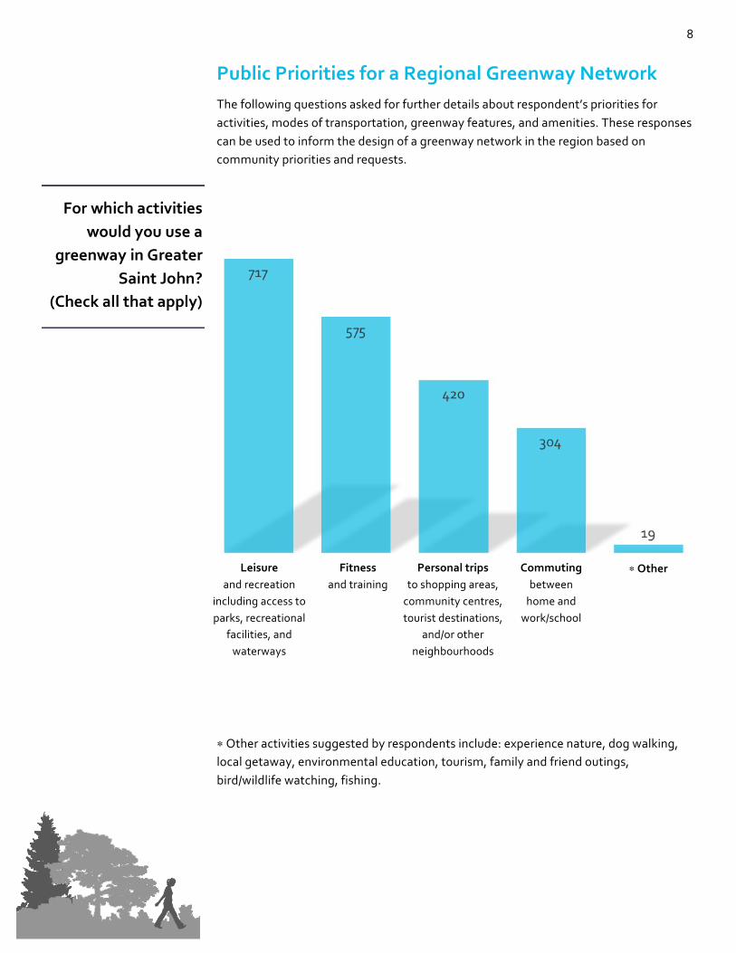
Public Priorities for a Regional Greenway Network The following questions asked for further details about respondent’s priorities for activities, modes of transportation, greenway features, and amenities. These responses can be used to inform the design of a greenway network in the region based on community priorities and requests.
Leisure
and recreation including access to parks, recreational
facilities, and waterways
Fitness and training
Personal trips to shopping areas,
community centres, tourist destinations,
and/or other neighbourhoods
Commuting between
home and work/school
∗ Other
∗ Other activities suggested by respondents include: experience nature, dog walking, local getaway, environmental education, tourism, family and friend outings, bird/wildlife watching, fishing.
For which activities would you use a
greenway in Greater Saint John?
(Check all that apply)

9
Walking,
hiking, running
Cycling Cross country skiing,
snowshoeing
Canoeing, kayaking
Skating Rollerblading, skateboarding, longboarding
∗Other
∗ Other modes of transportation suggested by respondents included: horseback riding, paddleboarding, skijoring/dogsledding, using a wheelchair, pushing strollers, ATVing, and snowmobiling. While some respondents suggested ATVing and snowmobiling, several other respondents reacted strongly against having any motorized vehicles on greenway trails.
Which modes of transportation would
you use on a greenway?
(Check all that apply)

10
Safety
(well lit, clean, maintained)
Greenway Experience
(access to natural areas, scenic
views)
Traffic Safety (separated from
vehicle traffic, less road
crossings)
Connectivity (to schools,
shopping areas, downtowns/main
streets, transit and/or ferries)
Comfort (flat trails,
limited hills, paved vs.
gravel)
Benches/
Picnic tables
Lookouts Parking areas
Gazebos/ sheltered
areas
Information panels about
nature, history,
etc.
Equipment rentals (bike,
kayak, canoe, ski,
etc.)
Bike racks and
repair stands
Of the following greenway facilities,
what is the most important to you?
Check your top 3
Of the following greenway features,
what is the most important to you?
Check your top 3

11
Additional features and facilities were suggested by survey respondents. They are listed from the most to least common.
• Washrooms (47) • Garbage and recycling bins (23) • Water fountains (16)
• Dog parks and dog bags (16) • Food and drink vendors (12) • Ongoing maintenance and landscaping (12) • Wayfinding maps (7) • Lights for nighttime safety and use (7) • Accessible for everyone (6) • Security cameras, patrols, help buttons, first aid kits (6)
• Parking access (5) • Exercise areas and sports fields (4) • Bike and equipment rentals (3) • Outdoor auditoriums and classrooms (3) • BBQs and firepits (3) • Water parks and outdoor pools (3) • Benches, rest areas, and hammocks (3) • Wifi and electricity access (3)
• Camping areas (2) • Connections to existing trails (1) • Connections with public transit (1) • Public art (1) • Access to a sledding hill (1) • Telescopes and binoculars (1) • Hedge maze (1) • Bumper boats (1)
• Playgrounds (1) • Mountain biking trails (1)
Are there additional greenway features
and/or facilities that are important to you?
If yes, please list:
12
Location Requests for Destinations and Connectivity Respondents of the survey were also asked which locations and destinations they would like to see connected by a regional greenway network. The following pages and maps describe the responses to this question. Maps show the distribution and number of mentions for the locations suggested by respondents.
This first map shows an overview of the requested locations in the region. The most popular locations included Uptown Saint John and Rockwood Park, as well as areas of the city including East Saint John, West Saint John, and North Saint John. Of the survey respondents, 72% are from Saint John which may explain why locations in Saint John received more requests than neighbouring municipalities and rural areas. One respondent also requested that the network extend to the Town of Sussex (not shown on the map).
What locations and destinations in
Greater Saint John do you think would
benefit from being connected by a
greenway? Please list:
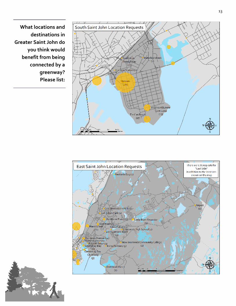
13
What locations and destinations in
Greater Saint John do you think would
benefit from being connected by a
greenway? Please list:

14
What locations and destinations in
Greater Saint John do you think would
benefit from being connected by a
greenway? Please list:
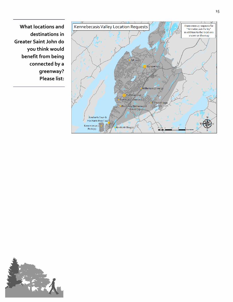
15
What locations and destinations in
Greater Saint John do you think would
benefit from being connected by a
greenway? Please list:

16
The following list of names where suggested by survey respondents. In addition to names, respondents provided suggestions of how to approach naming a regional greenway. One suggestion was to name each section of the network based on local contexts while following a common theme. Other suggestions were to use an indigenous name to recognize the people. A few people suggested letting a funder chose the name while a few others requested that it not be named after companies or politicians. Other comments requested that a competition be held for choosing a name so that anyone and everyone can be a part of the process.
• Acadian Trail • Ala'sit (Mi’kmaq for "go around") • Back to Nature • Be Seen in the Green • Better Way • Bivouac
• The Boulevard • Breathe Way • City Link • Connected Saint John • Connect Saint John (2) • Connect To Sea • Connection Trail
• David Goss Greenway • Eco Passage • EcoSJ • Emera Passage • Elsie Wayne Greenway • Experience Saint John • Explore Saint John • Fallsview Passage
• Flowers Without Borders • Freedom Ventures • Free Way • Fresh and Green • Fundy Green Belt • Fundy Green Path • Fundy Path • The Fundy Pathway
• Fundy Runway • Garden Gateway • Gathering Place • Getway • Glooscap Trails • Go Go SJ
• Greater Saint John Regional Greenway Greener Saint John (3)
• Green • Green Belt • Green Freedom • Green Haven • Green John • Green Mile • Green MOVEment
• Green SJ • Green Path • Green Passage (2) • Green Place • Greenway by the Bay • Green Way (3) • Greenway (4) • Greenway Boulevard
• Greenway Passage • Greenway Park • Greenway Port • Greenway Saint John • Greenway SJ • Green SJ (2) • Green Zone • Harbour Passage
• Harbour Passage Extension • Harbour Pathage • Harbour Trail • Healthy Walks Saint John • Irish Trails • Journey • Jungle Road of SJ
• Kennebecassis Trail System • Kings County Connection • Land and Sea
What name would you give to a regional Greenway for Greater
Saint John?

17
• Go Green • Great Outdoors • Greater Green • Greater Greenway (The GG)
• Greater Saint John Greenway • Greater SJ Greenway for Greater
Greener SJ
• Life Connection • Life Belt • Link (4) • Living Room
• Loyalist Connection • Loyalist Family Park & Trails • Loyalists Greens
• Loyalist Greenway • Loyalist Trail (7) • Major Brook Way • Marco Polo Trail • Maritime Pedestrian Trail
• Marsh Creek Passage • Marshland Greenway • Meadowlane • Mean Greenway • Micmac Trail • My Way • Nature Alley • Natures Beauty
• Nature Calls • Natures Pathway • Nature SJ • Nature Walk SJ • Nature Way (3) • North South East West Natural
Connection
• Novel Path • Open Path • The Old Ways • Original Trail
• Our Way • Outside Connection • Path (3) • Passage (3) • Passageway to Heath and Life • Peace Path • Peoples Way • Pioneers Trail
• Pleasant View • Portage Trail • Port City Connection • Port City Greenway (2) • Port City Green Connection
• Port City Trail • Port Path • Port City Passage (2) • Queens Green • Queens Way Trail
• Regional Greenway of Greater Saint John
• River Crossing • River Valley Green Space
• Roundabout • Saint John Connected • Saint John Green Belt • Saint John Green Connection • Saint John Green Line • Saint John Green Network • Saint John Greenway (6)
• Saint John Greenway Trail • Saint John Green Space • Saint John Nature Trail • Saint John Roots • Saint John Trail System • Sea Breeze • Sentier Saint John Trail • Scenic Route
• SJ Way • SJ Greenway (3) • SJ Pathways • String & Free Greenway • Sustainable SJ • Thomas Carleton Memorial Park • Trade Winds • Trailblaze SJ
• Trail Saint John • Trans SJ Pedway • Valley Greenway • Verdancy by the Bay • Verteway
What name would you give to a regional Greenway for Greater
Saint John?

18
• Port City Green Trail • Port City Passage • Port City Path (2) • Port City Pathway
• Port City Pedestrian Greenway • Port City Pedestrian Trail
• Wander Saint John • Wolastoq Greenway • The Yellow Brick Road • Your Place
• Zoe’s Park
What name would you give to a regional Greenway for Greater
Saint John?

19
Appendix The survey as it appeared on ACAP Saint John’s webpage.

20

21
ACAP Saint John is a non-profit charitable environmental organization that was formed in 1992. Our mission is to engage the multi-sectorial community of Greater Saint John in the collaborative management and restoration of our watersheds. ACAP Saint John works with those stakeholders in the community who share a common belief that an
industrialized urban center can support an abundance of functional natural capital. ACAP Saint John envisions a sustainable community that embraces the
interdependence of the unique social, economic, and environmental characteristics of the region’s watersheds.
Atlantic Coastal Action Program (ACAP) Saint John 76 Germain Street, PO Box 6878 Stn A
Saint John, New Brunswick, E2L 4S3
Phone: 506.652.2227 Fax: 506.633.2184
E-mail: [email protected] Website: www.acapsj.org
This survey was funded by the New Brunswick Environmental Trust Fund. Thanks to this support we have been able to collect public opinions about developing a greenway
network in the Greater Saint John Region. This information will be invaluable for greenway initiatives in the future.
Atlantic Coastal Action Program
(ACAP) Saint John & Government of New
Brunswick


