Bangkok, Thailand, 5-13 February 2018 WMO/ASEAN Training Workshop on Weather Radar Data Quality and Standardization 4. Weather radar Data Quality Control 4.1 Calibration 4.2 Noise reduction 6, 7 February 2018 Masahito ISHIHARA Former Meteorologist/Researcher of Japan Meteorological Agency Former Professor of Kyoto University 1
Transcript
Bangkok, Thailand, 5-13 February 2018
WMO/ASEAN Training Workshop on Weather Radar Data Quality and Standardization
4. Weather radar Data Quality Control4.1 Calibration4.2 Noise reduction
6, 7 February 2018
Masahito ISHIHARAFormer Meteorologist/Researcher of Japan Meteorological AgencyFormer Professor of Kyoto University
1
Bangkok, Thailand, 5-13 February 2018
WMO/ASEAN Training Workshop on Weather Radar Data Quality and Standardization
4. Weather radar Data Quality Control4.1 Calibrationa. Calibration for radar equipment
was lectured by Mr. Inoue in the Session 2 “Weather Radar Maintenance”.
b. Calibration for quantitative Precipitation Estimationwill be lectured by Mr. Sakanashi in the Session 7.3 “QPE & QPF”.
4.2 Noise reductiona. Noises (Error sources) on weather radar observationb. Necessity and methods of noise reduction in weather radar
observationWill be lectured by Mr. Yamauchi and Mr. Hotta in the Session 5 “Hands-on Training on Weather Radar QC”.
2
Bangkok, Thailand, 5-13 February 2018
WMO/ASEAN Training Workshop on Weather Radar Data Quality and Standardization
Error sources on weather radar observation
Source: Guide to Meteorological Instruments and Methods of Observation, 2014, WMO3
Bangkok, Thailand, 5-13 February 2018
WMO/ASEAN Training Workshop on Weather Radar Data Quality and Standardization
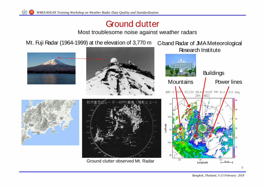
Ground clutter
4
Most troublesome noise against weather radars
Power linesMountainsBuildings
Mt. Fuji Radar (1964-1999) at the elevation of 3,770 m C-band Radar of JMA Meteorological Research Institute
Ground clutter observed Mt. Radar
Bangkok, Thailand, 5-13 February 2018
WMO/ASEAN Training Workshop on Weather Radar Data Quality and Standardization
5
Rain echoes
Rain echoes
Rain & ground echoes
Sig
nal i
nten
sity
(dB
)Ground clutter remover
- Non-coherent MTI for non-Doppler radars -
Original signal X(t) X(t-Td)Delay Td
Ground-removed signal Y(t)Non-Filtered Filtered
Y(t) fluctuating components of X(t)
X(t) Original signal
Bangkok, Thailand, 5-13 February 2018
WMO/ASEAN Training Workshop on Weather Radar Data Quality and Standardization
6
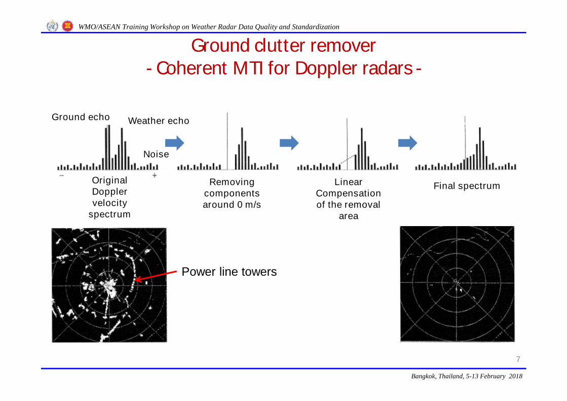
Ground clutter remover- Coherent MTI for Doppler radars -
Received signal
Continuous signal
Transmitting pulse Amplifying
Amplifying & to Intermedium frequency
Phase detector
In-phase channel signal (I)
Quadrature-phase channel signal (Q)
distance distance
Time series of I & Q complex signal
Fourier transform
Doppler velocity Doppler velocity
Ground echo
Weather echoGround echo is removed
Coherent MTI
Bangkok, Thailand, 5-13 February 2018
WMO/ASEAN Training Workshop on Weather Radar Data Quality and Standardization
7
Ground clutter remover- Coherent MTI for Doppler radars -
Weather echoGround echo
Original Doppler velocity
spectrum
Noise
Removing components around 0 m/s
Linear Compensation of the removal
area
Final spectrum
Power line towers
Bangkok, Thailand, 5-13 February 2018
WMO/ASEAN Training Workshop on Weather Radar Data Quality and Standardization
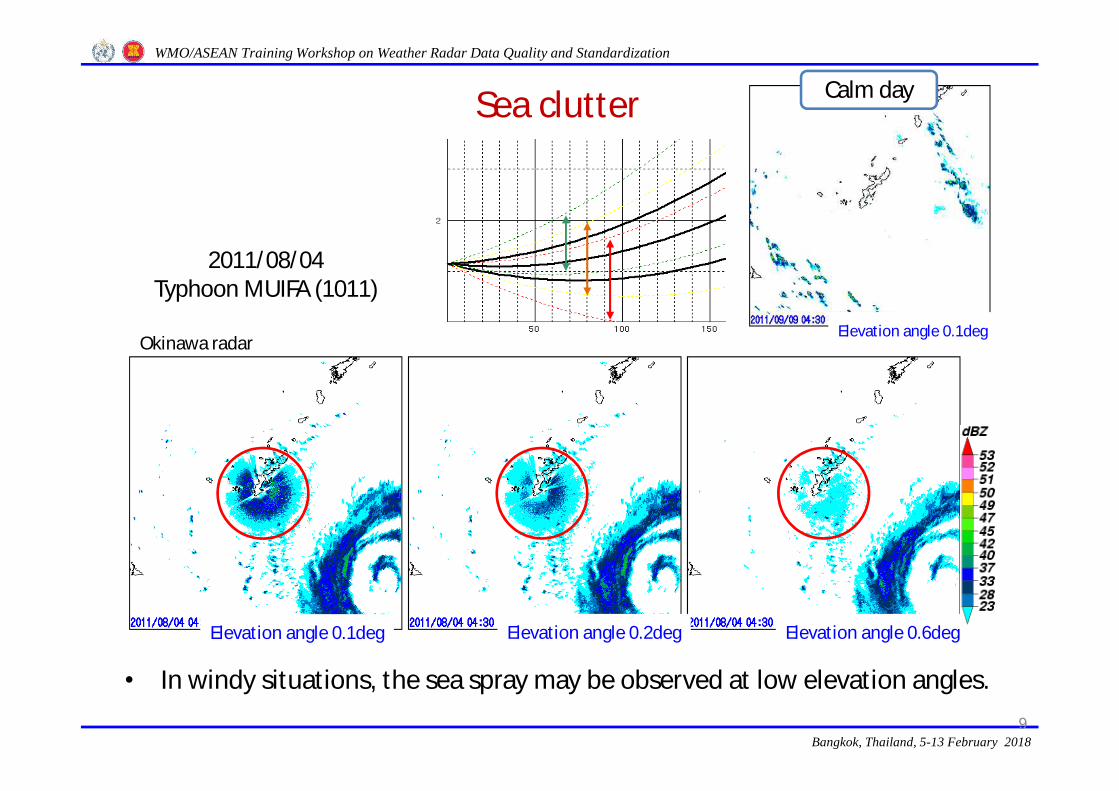
Sea clutter
8
Sea
Elevated radar
Low-elevation angle beam
Ground clutter
Sea clutter
Typhoon echoes
Mt. Fuji Radar (1964-1999)
Scattered by sea waves and sea water spray
Bangkok, Thailand, 5-13 February 2018
WMO/ASEAN Training Workshop on Weather Radar Data Quality and Standardization
Sea clutter
9
• In windy situations, the sea spray may be observed at low elevation angles.
WMO/ASEAN Training Workshop on Weather Radar Data Quality and Standardization
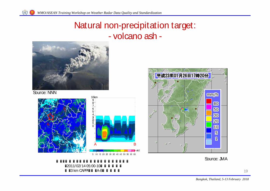
Natural non-precipitation target: - volcano ash -
19
Source: NNN
Source: JMA図3.層状エコーと噴煙エコーが混在する事例
(2011/02/14 05:00-10新燃岳噴火)左:3 km CAPPI,右:A-B間鉛直断面
A B
10km9876543210A
B
Bangkok, Thailand, 5-13 February 2018
WMO/ASEAN Training Workshop on Weather Radar Data Quality and Standardization
Beam blockage due to mountains/buildings
20
No blockagePartial blockage
Full blockage
rk 0.2-L1.0-22
e
6222t
3
rg1010
r 2log 1024D |K| h G P P
θπ
Partial blockage of a radar beam makes reduction of beam width 𝜃 ,and then leads the fault reflectivity measurement.
Reduced due to blockages
Bangkok, Thailand, 5-13 February 2018
WMO/ASEAN Training Workshop on Weather Radar Data Quality and Standardization
Lack of beam filling
21Source: Guide to Meteorological Instruments and Methods of Observation, 2014, WMO
Ratio of accumulated precipitation amount<Rain-gauge/Radar (dB)>
Bangkok, Thailand, 5-13 February 2018
WMO/ASEAN Training Workshop on Weather Radar Data Quality and Standardization
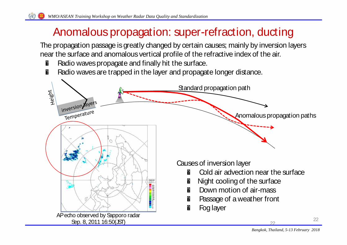
Anomalous propagation: super-refraction, ducting
2222
Causes of inversion layer○ Cold air advection near the surface○ Night cooling of the surface○ Down motion of air-mass○ Passage of a weather front○ Fog layer
Standard propagation path
Anomalous propagation paths
The propagation passage is greatly changed by certain causes; mainly by inversion layers near the surface and anomalous vertical profile of the refractive index of the air.⇒ Radio waves propagate and finally hit the surface. ⇒ Radio waves are trapped in the layer and propagate longer distance.
AP echo observed by Sapporo radarSep. 8, 2011 16:50(JST)
Bangkok, Thailand, 5-13 February 2018
WMO/ASEAN Training Workshop on Weather Radar Data Quality and Standardization
Electromagnetic interference
23
Interference with another rotating radar Interference with continuous radio waves
Bangkok, Thailand, 5-13 February 2018
WMO/ASEAN Training Workshop on Weather Radar Data Quality and Standardization
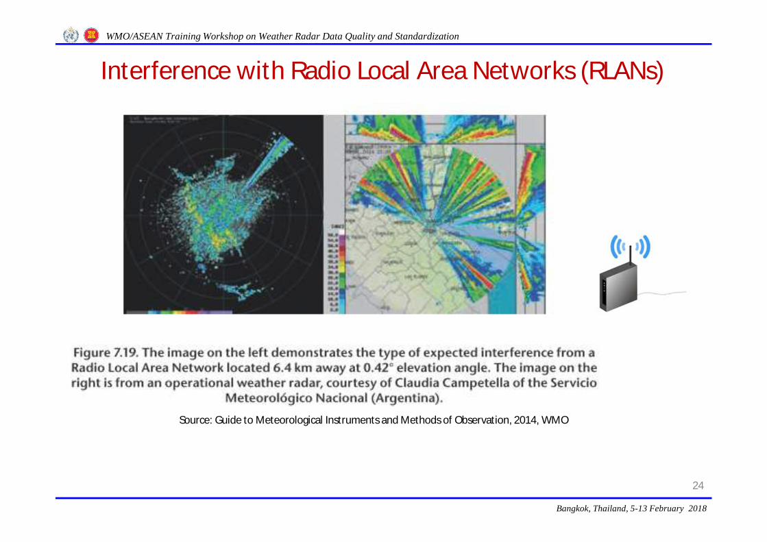
Interference with Radio Local Area Networks (RLANs)
24
Source: Guide to Meteorological Instruments and Methods of Observation, 2014, WMO
Bangkok, Thailand, 5-13 February 2018
WMO/ASEAN Training Workshop on Weather Radar Data Quality and Standardization
Interference with Radio Local Area Networks (RLANs)
25
Electromagnetic interference from other radars or devices, such as Radio Local Area Networks (RLANs), is becoming increasingly significant, requiring substantial diligence to protect against it. Interference among adjacent radars is mitigated through the use of slightly different frequencies (but still in the same band) with appropriate filters on the transmitter and receiver. There may be occasional interference from airborne and ground-based C band radars using the same frequency.Use of the electromagnetic spectrum is determined by agreement and managed through the International Telecommunication Union. At the World Radiocommunication Conference 2003, the C band frequencies were opened up to the telecommunication industry on a regulated secondary non-interfering non-licensed basis to be shared with the meteorological community. In order to be non-interfering, the RLAN devices are supposed to implement Dynamic Frequency Selection, which is designed to vacate a C band channel if a weather radar is detected. However, the algorithms used to detect the weather radar are not sufficient to prevent interference before they vacate the channel. The Doppler spectra of RLAN signals appear as white noise and can be removed with adaptive noise techniques. However, they increase the noise level and reduce the sensitivity of the weather radar where the RLAN is detected. WMO has issued guidance statements relating to the co-use of the C band frequencies.
Source: Guide to Meteorological Instruments and Methods of Observation, 2014, WMO
Bangkok, Thailand, 5-13 February 2018
WMO/ASEAN Training Workshop on Weather Radar Data Quality and Standardization
SimplifiedRadio Regulations of International Telecommunication Union
(RR ITU) around C-band weather radars
26
• Radio LANs must monitor weather radar signal at the first one minute of their operation.• If weather radar signal is received during their operation, radio LANs must shift their
frequency bands.
Radiolocation station
Mobile station Mobile station Mobile station
Marine/aviation radar
Radio LANs Radio LANs
JAPAN
RR Region 3
Weather radar
Bangkok, Thailand, 5-13 February 2018
WMO/ASEAN Training Workshop on Weather Radar Data Quality and Standardization