Developer Summit 2007 Developer Summit 2007 1 1 Working with the Working with the ArcGIS ArcGIS Server Web Services API Server Web Services API Sud Menon, Julio Andrade Sud Menon, Julio Andrade
Transcript
Developer Summit 2007Developer Summit 2007 11
Working with the Working with the ArcGISArcGIS Server Web Services APIServer Web Services API
Sud Menon, Julio AndradeSud Menon, Julio Andrade
Developer Summit 2007Developer Summit 2007 22
Presentation outlinePresentation outline
•• Brief overview of Brief overview of ArcGISArcGIS Server GIS Web ServicesServer GIS Web Services
•• Description of 9.2 GIS Web ServicesDescription of 9.2 GIS Web Services–– Functional capabilities of each serviceFunctional capabilities of each service–– The SOAP API for the serviceThe SOAP API for the service–– Sample applications that consume the serviceSample applications that consume the service
•• Under the Hood Under the Hood –– Implementation details of interest to youImplementation details of interest to you
Developer Summit 2007Developer Summit 2007 33
Our assumptionsOur assumptions
•• You have a high level understanding of :You have a high level understanding of :
–– ArcGISArcGIS ServerServer–– The The ArcGISArcGIS Information ModelInformation Model–– Web servicesWeb services
•• You can read C# codeYou can read C# code
Developer Summit 2007Developer Summit 2007 44
What Are Web services?What Are Web services?
•• Network accessible interface or application Network accessible interface or application functionality, built using standard Internet functionality, built using standard Internet technologiestechnologies
Discovery UDDI
Description WSDLXML Messaging SOAP,XML
Transport HTTP,SMTP,FTP
Network Web Service
•• Web service technology stackWeb service technology stack
Developer Summit 2007Developer Summit 2007 55
Services can be used to Display DataServices can be used to Display Data
Developer Summit 2007Developer Summit 2007 66
Services can be used to Answer QuestionsServices can be used to Answer Questions
Developer Summit 2007Developer Summit 2007 77
GIS Web ServicesGIS Web Services
•• ArcGISArcGIS Server includes a rich set of out of the box GIS Web ServicesServer includes a rich set of out of the box GIS Web Services
•• SOAPSOAP–– 2D Map Service2D Map Service–– 3D Map / Globe Service3D Map / Globe Service–– Geocoding ServiceGeocoding Service–– Network Analysis ServiceNetwork Analysis Service–– Geoprocessing ServiceGeoprocessing Service–– Geodata ServiceGeodata Service–– Mobile Data ServiceMobile Data Service
•• OGCOGC–– WMS ServiceWMS Service
•• KMLKML–– KML ServiceKML Service
•• Publish and Deploy using Manager Publish and Deploy using Manager –– no programming requiredno programming required
Developer Summit 2007Developer Summit 2007 88
ArcGISArcGIS Server Server –– Publishing GIS Web ServicesPublishing GIS Web Services
•• Author GIS resources (Author GIS resources (egeg maps, locators) using desktop.maps, locators) using desktop.
•• Publish GIS resources to create GIS Services.Publish GIS resources to create GIS Services.
•• A GIS Service may have multiple capabilities A GIS Service may have multiple capabilities –– EgEg Mapping, Network AnalysisMapping, Network Analysis
•• Each capability is exposed to consumers as a GIS Web Service Each capability is exposed to consumers as a GIS Web Service accessible over HTTP accessible over HTTP
Step 2: Enable Web Access in Manager or ArcCatalog
Step 1: Publish a GIS Service
Step 3: Use with ArcGIS / Web ADF / Custom Clients
Developer Summit 2007Developer Summit 2007 99
ArcGISArcGIS Server GIS Web Services Server GIS Web Services --Out of the Box ClientsOut of the Box Clients
•• ArcGISArcGIS Explorer and Explorer and ArcGISArcGIS Desktop are out of the Desktop are out of the box Desktop Clientsbox Desktop Clients
•• You can use Manager wizards to build Web Mapping You can use Manager wizards to build Web Mapping Applications that consume GIS Web Services Applications that consume GIS Web Services –– no programming requiredno programming required
Developer Summit 2007Developer Summit 2007 1010
Web Server Web Server
Web BrowserWeb Browser
ArcGISArcGIS Server 9.2 Server 9.2 Security ZonesSecurity Zones
ArcMap, ArcMap, ArcGlobeArcGlobe
Content AuthorContent Author
ArcCatalog ArcCatalog AdministratorAdministrator
GeodatabasesGeodatabases
ArcGISArcGIS Explorer, Explorer,
ArcGISArcGIS Desktop,Desktop,
other other ArcGISArcGIS ServersServers
GIS ServerGIS Server
Web Web BrowserBrowser
ArcGISArcGIS Server SystemServer System
Web Mapping Web Mapping ApplicationsApplications
GIS Services GIS Services --Web Service EndpointsWeb Service Endpoints
Users External to the SiteUsers External to the Site Users Internal to the Site :Users Internal to the Site :Authors, Publishers,Authors, Publishers,
AdministratorsAdministrators
HTTPHTTP DCOMDCOM
ArcGISArcGIS Server SiteServer Site
Developer Summit 2007Developer Summit 2007 1111
Options for Developing Custom Client Applications that Options for Developing Custom Client Applications that use GIS Web Servicesuse GIS Web Services
•• Work with the Web ADF object model (for web apps) Work with the Web ADF object model (for web apps) –– Work with the Web ADF common object model and controlsWork with the Web ADF common object model and controls–– Use the Use the ArcGISArcGIS Server Internet data sourceServer Internet data source
•• Work with Work with ArcGISArcGIS Engine (for desktop apps)Engine (for desktop apps)–– Use the Use the ArcEngineArcEngine object model and controlsobject model and controls–– Use the GIS Client Use the GIS Client ArcObjectsArcObjects library and builtlibrary and built--in in ArcObjectsArcObjects
proxies for each web serviceproxies for each web service
•• Work directly with the web service Work directly with the web service apiapi–– The focus of this presentationThe focus of this presentation–– You can use preYou can use pre--generated proxies that ship with the .Net and Java generated proxies that ship with the .Net and Java
Web Web ADFsADFs, , egeg ESRI.ArcGIS.ADF.ArcGISServerESRI.ArcGIS.ADF.ArcGISServer–– You can generate the proxies yourself using your You can generate the proxies yourself using your favouritefavourite wsdlwsdl
tooltool
Developer Summit 2007Developer Summit 2007 1212
Web ADF Development PathsWeb ADF Development Paths
Web ControlsWeb Controls
Common Data Source APICommon Data Source API
Data Source (GIS Server) Specific APIsData Source (GIS Server) Specific APIs
GenericGeneric
DeveloperPaths I II III IV
•• This talk focuses on path IVThis talk focuses on path IV
Data Source ImplementationsData Source Implementations
Developer Summit 2007Developer Summit 2007 1313
The The ArcGISArcGIS Server Web Services APIServer Web Services API
•• Coarse GrainedCoarse Grained
•• StatelessStateless
•• Described by a Described by a wsdlwsdl
•• Methods take Methods take serializableserializable Value objects (simple structures) as parametersValue objects (simple structures) as parameters
•• VallueVallue Objects are based on existing well known Objects are based on existing well known ArcObjectsArcObjects typestypes–– EgEg Color, Symbol, Graphic Element, Geometries, Color, Symbol, Graphic Element, Geometries, DataElementsDataElements
•• StraightforwardStraightforward
•• PowerfulPowerful
Developer Summit 2007Developer Summit 2007 1414
serviceserviceserviceservice
serviceservice
Working with a SOAP serviceWorking with a SOAP service
•• You work with Proxies and Value objects You work with Proxies and Value objects –– Generated from a WSDL using a SOAP toolkitGenerated from a WSDL using a SOAP toolkit
Value objectValue objectValue objectValue object
Value objectValue object Proxy objectProxy object
Client ApplicationClient Application ServerServer
WSDLWSDL
End Point End Point
SOAPSOAPToolkitToolkit Get WSDLGet WSDL
GenerateGenerate
Developer Summit 2007Developer Summit 2007 1515
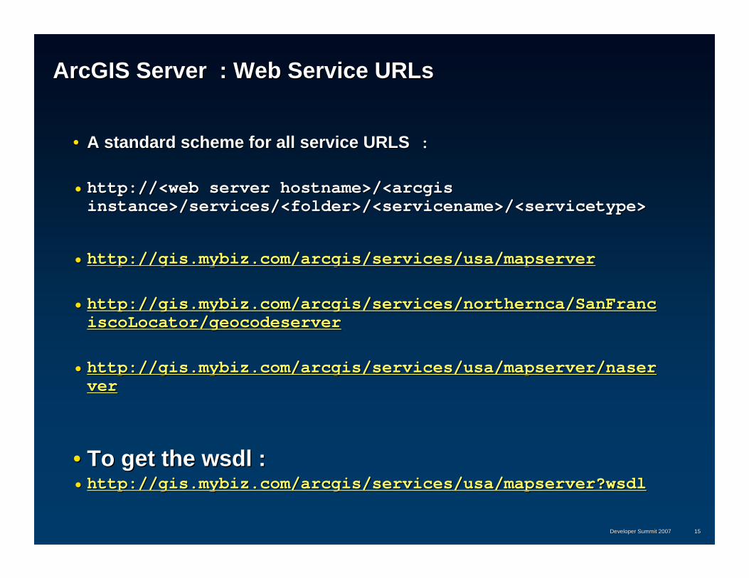
ArcGISArcGIS Server : Web Service URLsServer : Web Service URLs
•• A standard scheme for all service URLSA standard scheme for all service URLS ::
•• http://<web server hostname>/<http://<web server hostname>/<arcgisarcgisinstance>/services/<folder>/<instance>/services/<folder>/<servicenameservicename>/<>/<servicetypeservicetype>>
http://<web server hostname>/<http://<web server hostname>/<arcgisarcgis instance>/instance>/services?wsdlservices?wsdl
GetServiceDescriptionsGetServiceDescriptions
Developer Summit 2007Developer Summit 2007 1717
Map ServiceMap Service
•• Based on a Map Document (.Based on a Map Document (.mxdmxd) authored using ) authored using ArcMapArcMap•• Can be used to generate mapCan be used to generate map images in a variety of image images in a variety of image
formatsformats•• Callers can supply additional information to be overlaid on Callers can supply additional information to be overlaid on
the map the map –– GraphicsGraphics–– Selection IDs and buffer distancesSelection IDs and buffer distances
•• Can be used to identify featuresCan be used to identify features•• Can be used to query featuresCan be used to query features
–– Results returned as Results returned as GeodatabaseGeodatabase record setsrecord sets–– Easily marshaled by valueEasily marshaled by value–– Can be converted to ADO.NET datasetsCan be converted to ADO.NET datasets
Developer Summit 2007Developer Summit 2007 1818
Map ServiceMap Service
•• Maps can be preMaps can be pre--rendered and cached for performance rendered and cached for performance resulting in a tiled map service that has a fixed set of scalesresulting in a tiled map service that has a fixed set of scales
•• Methods to discover if Methods to discover if –– A map is a tiled fixed scale map A map is a tiled fixed scale map –– If the map tiles correspond to single fused images or if there aIf the map tiles correspond to single fused images or if there are re
separate tiles for each layerseparate tiles for each layer
•• Methods to get the tiling schemeMethods to get the tiling scheme•• Methods to fetch tilesMethods to fetch tiles•• Tiles can also be obtained directly via HTTP Get.Tiles can also be obtained directly via HTTP Get.
Developer Summit 2007Developer Summit 2007 1919
Working with the Map ServiceWorking with the Map Service
// Drawing the map - generating map images
MapImage mi = ms.ExportMapImage (mapDescription, imageDescription);
Map Service Map Service –– Methods for working with tiled map servicesMethods for working with tiled map services
Gets the virtual cache directory for the map, if Gets the virtual cache directory for the map, if presentpresent
GetVirtualCacheDirectoryGetVirtualCacheDirectory
Gets the specified tile for the map given tile Gets the specified tile for the map given tile levellevel, , rowrow and and columncolumn coordinatescoordinates
GetMapTileGetMapTile
Gets the tiling scheme for the mapGets the tiling scheme for the mapGetTileCacheInfoGetTileCacheInfo
Indicates that the map has a single cache that Indicates that the map has a single cache that prefusesprefuses all layers all layers
HasSingleFusedMapCacheHasSingleFusedMapCache
Indicates that the map has a fixed set of Indicates that the map has a fixed set of LODsLODsIsFixedScaleMapIsFixedScaleMap
Developer Summit 2007Developer Summit 2007 3333
Tile Cache Info Object :Tile Cache Info Object :
Properties that describe a tiling schemeProperties that describe a tiling scheme
The levels of detail in the cache The levels of detail in the cache
{id, scale, resolution}{id, scale, resolution}
LODInfosLODInfos
The number of columns in a tileThe number of columns in a tileTileColsTileCols
Resolution in dots per inch Resolution in dots per inch DPIDPI
The spatial reference of the cacheThe spatial reference of the cacheSpatialReferenceSpatialReference
The number of rows in a tileThe number of rows in a tileTileRowsTileRows
The origin for the tiling gridThe origin for the tiling gridOriginOrigin
ArcGISArcGIS Server Server -- GIS Web Services and GIS Web Services and ArcObjectsArcObjects
•• Each Each ArcGISArcGIS Server web service has a corresponding coarse Server web service has a corresponding coarse grained grained ArcObjectArcObject (a Server Object) which supports a logically (a Server Object) which supports a logically equivalent equivalent ArcObjectsArcObjects interfaceinterface
IMapServerIMapServerMapServerMapServerMap ServiceMap Service
ArcObjectsArcObjects --InterfaceInterface
ArcObjectsArcObjects --ServerObjectServerObject
Web ServiceWeb Service
Developer Summit 2007Developer Summit 2007 3535
Drawing a map Drawing a map –– equivalent equivalent ArcObjectArcObject modelmodel
Developer Summit 2007Developer Summit 2007 3636
ArcGISArcGIS Server Server -- GIS Web Services and GIS Web Services and ArcObjectsArcObjects
•• The The ArcObjectsArcObjects object model for a service is available on both the object model for a service is available on both the server (server (ServerObjectServerObject running within the running within the ServerContextServerContext) ) and on the and on the clientclient..
•• The client object model consists of a server object proxy and alThe client object model consists of a server object proxy and all the l the value typesvalue types
•• The The GISClientGISClient assembly can be used to connect to a server and assembly can be used to connect to a server and obtain proxies.obtain proxies.
Developer Summit 2007Developer Summit 2007 3737
Globe Services Globe Services
•• Efficiently deliver Efficiently deliver globe layersglobe layers for display on a for display on a 3D Map / Globe3D Map / Globe
•• Deliver Deliver animationsanimations
•• Support Support identifyidentify and and find featuresfind features functionalityfunctionality
•• Support web based accessSupport web based access
•• Clients can mix and match different servicesClients can mix and match different services
Developer Summit 2007Developer Summit 2007 3838
•• Any globe enabled ArcGIS ClientAny globe enabled ArcGIS Client–– ArcGISArcGIS ExplorerExplorer–– ArcGISArcGIS Desktop Applications Desktop Applications -- ArcGlobe and ArcCatalog ArcGlobe and ArcCatalog –– ArcReaderArcReader–– ArcGISArcGIS Engine Applications based on the GlobeControlEngine Applications based on the GlobeControl
Applications that work with Globe Services Applications that work with Globe Services
ArcGIS ExplorerArcGIS Explorer ArcReaderArcReader
Developer Summit 2007Developer Summit 2007 3939
Globe Service Globe Service –– Publishers ViewPublishers View
•• Based on a Globe document (.3dd) authored using Based on a Globe document (.3dd) authored using ArcGlobeArcGlobe
•• Exposes a set of individually consumable Globe LayersExposes a set of individually consumable Globe Layers
•• Returns tiles for each layer that are optimized for display on aReturns tiles for each layer that are optimized for display on a3D Globe3D Globe
•• Tiles are in the Cube projection and use a fixed tiling scheme.Tiles are in the Cube projection and use a fixed tiling scheme.
•• ArcGISArcGIS Explorer, Explorer, ArcGlobeArcGlobe and the Globe control have the and the Globe control have the ability to drape these tiles on the globeability to drape these tiles on the globe
Developer Summit 2007Developer Summit 2007 4040
•• ElevationElevation
•• ImageryImagery
•• Draped 2D VectorsDraped 2D Vectors
•• Draped 2D TextDraped 2D Text
•• 3D Vectors (3D Vectors (egeg. buildings). buildings)
•• 3D Graphics and Text (bill boarded)3D Graphics and Text (bill boarded)
Types of Globe Layers Delivered by a Globe ServiceTypes of Globe Layers Delivered by a Globe Service
Developer Summit 2007Developer Summit 2007 4141
Globe Service Globe Service –– DeveloperDeveloper’’s Views View
•• Intended to be used within an Intended to be used within an ArcEngineArcEngine application that is based application that is based on the Globe Controlon the Globe Control
•• Use the Use the ArcObjectsArcObjects API for working with API for working with ArcGISArcGIS ServerServer
Developer Summit 2007Developer Summit 2007 4242
ArcGIS Server 9.2 GeoprocessingArcGIS Server 9.2 Geoprocessing
•• Allows organizations to centralize both data and Allows organizations to centralize both data and processing on the serverprocessing on the server
•• Allows organizations with spatial data to expose spatial Allows organizations with spatial data to expose spatial analysis functionality against that data as easy to use analysis functionality against that data as easy to use tasks that can be invoked by less experienced userstasks that can be invoked by less experienced users
•• Allows GIS Analysts to easily author and publish Allows GIS Analysts to easily author and publish geoprocessing modelsgeoprocessing models
Working directly with the Working directly with the GeoprocessingGeoprocessing ServiceService
•• Methods toMethods to ::
–– List the toolsList the tools–– Get information on the parameters for each toolGet information on the parameters for each tool
•• Name, Type, Default Value, Name, Type, Default Value, ……–– Execute a tool synchronouslyExecute a tool synchronously–– Execute a tool asynchronouslyExecute a tool asynchronously
•• Returns a Job IDReturns a Job ID•• Methods to discover status of pending jobsMethods to discover status of pending jobs•• Methods to download results for completed jobsMethods to download results for completed jobs•• Methods to draw results for completed jobs on the server using aMethods to draw results for completed jobs on the server using an n
associated map serviceassociated map service
•• Note : Note : –– Web ADF, Explorer and Desktop include a Web ADF, Explorer and Desktop include a GeoprocessingGeoprocessing
Task that will Task that will autogenerateautogenerate UI dialogs for any published GP UI dialogs for any published GP tool.tool.
Developer Summit 2007Developer Summit 2007 4545
GeoprocessingGeoprocessing Service Service -- ParametersParameters
•• Supported parameter typesSupported parameter types–– StringString–– LongLong–– DoubleDouble–– BooleanBoolean–– Linear unitLinear unit–– Feature record setFeature record set–– Table record setTable record set–– Raster dataRaster data–– Map Layer on the server Map Layer on the server
Developer Summit 2007Developer Summit 2007 4646
Geoprocessing Service PropertiesGeoprocessing Service Properties
•• Execution Mode :Execution Mode :
–– SynchronousSynchronous•• Results calculated and returned immediately by valueResults calculated and returned immediately by value•• Appropriate for fast tools with small resultsAppropriate for fast tools with small results
–– AsynchronousAsynchronous•• Allows client to submit a job and come back later to fetch or drAllows client to submit a job and come back later to fetch or draw aw
resultsresults•• Results are saved on the serverResults are saved on the server•• large results are best left on the serverlarge results are best left on the server
Developer Summit 2007Developer Summit 2007 4747
GeoprocessingGeoprocessing Service Service –– Object ModelObject Model
if (pi.ChoiceList != null){sb.Append("\tChoiceList:\n");foreach(string choice in pi.ChoiceList)sb.Append("\t\t" + choice + "\r\n");
}}MessageBox.Show(sb.ToString(), "ToolInfo");
Developer Summit 2007Developer Summit 2007 5151
Executing Executing a toola tool
Developer Summit 2007Developer Summit 2007 5252
GeodataGeodata Services and ReplicationServices and Replication
•• Geodata Services allow you to publish a geodatabase Geodata Services allow you to publish a geodatabase so that it can be accessed remotely over the Webso that it can be accessed remotely over the Web
•• ArcGIS Desktop can be used as a client with both ArcGIS Desktop can be used as a client with both local and remote geodatabases in order tolocal and remote geodatabases in order to–– Extract data Extract data –– Create replicasCreate replicas–– Synchronize replicasSynchronize replicas
Developer Summit 2007Developer Summit 2007 5353
Working with Working with GeodataGeodata Services in Services in ArcGISArcGIS DesktopDesktop
•• All the distributed database tools work with local All the distributed database tools work with local geodatabase connections as well as with geodata geodatabase connections as well as with geodata services (services (““ remote geodatabase connections remote geodatabase connections ““))
•• GIS Analysts can also use GP scripting to setup GIS Analysts can also use GP scripting to setup automated synchronization jobs that automatically automated synchronization jobs that automatically synchronize geodatabases at periodic intervalssynchronize geodatabases at periodic intervals
Developer Summit 2007Developer Summit 2007 5454
GeodataGeodata ServiceService
•• Methods for Methods for
–– browsing datasetsbrowsing datasets
–– exporting datasets to XMLexporting datasets to XML
–– creating checkcreating check--out, 1 way and 2 way replicas that can be down out, 1 way and 2 way replicas that can be down loaded and editedloaded and edited
–– exporting and importing replica changes.exporting and importing replica changes.
Developer Summit 2007Developer Summit 2007 5555
GeodataGeodata Service Service –– Object ModelObject Model
GeodataGeodata Service demo Service demo –– data extractiondata extraction
GDBGDB GDSGDS
MXDMXD MapSMapS
WebWebServerServer clientclient
GIS ServerGIS Server
Developer Summit 2007Developer Summit 2007 5757
GeodataGeodata Service Service -- Creating a replicaCreating a replica
Developer Summit 2007Developer Summit 2007 5858
GeodataGeodata Service Service -- Creating a replicaCreating a replica
//create array of datasetsGPReplicaDataset[] repDSs = new GPReplicaDataset[2];
//fill it up w/datasets to replicateGPReplicaDataset repDS = new GPReplicaDataset();repDS.DatasetName = "Parcels";repDS.DatasetType = esriDatasetType.esriDTFeatureClass;//selection IDs, UseGeometry, DefQuery...repDSs[0] = repDS;
repDS = new GPReplicaDataset();repDS.DatasetName = "Buildings";repDS.DatasetType = esriDatasetType.esriDTFeatureClass;repDSs[1] = repDS;
//setup a replicaDescriptionGPReplicaDescription repDesc = new GPReplicaDescription();repDesc.GPReplicaDatasets = repDSs;repDesc.QueryGeometry = myEnvelope;repDesc.SingleGeneration = true; //ie checkOut …
Developer Summit 2007Developer Summit 2007 5959
GeodataGeodata Service Service -- Creating a replicaCreating a replica
//extra optionsGPReplicaOptions repOpts = new GPReplicaOptions();repOpts.AccessType = esriReplicaAccessType.esriReplicaBothReadWrite;
//how to format the dataGDSExportOptions expOpts = new GDSExportOptions();expOpts.ExportFormat = esriGDSExportFormat.esriGDSExportFormatFileGDB;
//how to transfer the dataesriGDSTransportType transpType = esriGDSTransportType.esriGDSTransportTypeUrl;
Developing Desktop and Developing Desktop and ArcEngineArcEngine Clients to the Clients to the GeodataServiceGeodataService
•• Use the Use the GeoDataServerGeoDataServer and and ReplicationAgentReplicationAgent classes that classes that are part of the are part of the GeodatabaseDistributedGeodatabaseDistributedArcObjectsArcObjects assemblyassembly
•• ReplicationAgentReplicationAgent gives you gives you single call synchronizationsingle call synchronization
GeoDataServer1(proxy)
ReplicationAgent
GeoDataServer2(proxy)
Geodatabase
GeoDataServer2
Geodatabase
GeoDataServer1
Internet Internet
Developer Summit 2007Developer Summit 2007 6262
GeocodeGeocode ServiceService
•• Based on a Locator stored in the file system or in a Based on a Locator stored in the file system or in a GeodatabaseGeodatabase
•• 9.2 has new high performance locators9.2 has new high performance locators
•• Methods to perform single address and batch Methods to perform single address and batch geocodinggeocoding
•• Methods to perform reverse Methods to perform reverse geocodinggeocoding
•• Support for different address stylesSupport for different address styles
Developer Summit 2007Developer Summit 2007 6363
Network Analysis ServiceNetwork Analysis Service
•• Based on publishing a map containing network Based on publishing a map containing network analysis layersanalysis layers
•• A network analysis layer represents a specific analysis A network analysis layer represents a specific analysis (Routing, Service Area, Closest Facility) to be (Routing, Service Area, Closest Facility) to be performed against a specific network dataset (for performed against a specific network dataset (for egeg. . LA Streets)LA Streets)
•• Methods to :Methods to :–– Discover the parameters of the analysis solverDiscover the parameters of the analysis solver–– SolveSolve–– Get Results (paths, directions etc)Get Results (paths, directions etc)
•• Callers supply input parameters (for Callers supply input parameters (for egeg stops, barriers) stops, barriers) using basic web service types such as using basic web service types such as PropertySetsPropertySetsand and RecordSetsRecordSets..
Developer Summit 2007Developer Summit 2007 6464
Network Analysis Service Network Analysis Service –– Object ModelObject Model
Perform Network Analysis based on the Perform Network Analysis based on the specified solver parametersspecified solver parameters
SolveSolve
Default Solver Parameters for the specified Default Solver Parameters for the specified Network Analysis LayerNetwork Analysis Layer
GetSolverParametGetSolverParametersers
Returns the Network Dataset Data Element Returns the Network Dataset Data Element for the specified layerfor the specified layer
GetNetworkDescriGetNetworkDescriptionption
Array of Network Analysis Layers of a Array of Network Analysis Layers of a particular typeparticular type
GetNALayerNamesGetNALayerNames
Developer Summit 2007Developer Summit 2007 6666
GeocodingGeocoding and Network Analysis Service demo and Network Analysis Service demo -- routingrouting
NANA
MXDMXD MapSMapS
WebWebServerServer WebAppWebApp
NDND
LocatorLocator GeocodeSGeocodeS
GIS ServerGIS Server
Developer Summit 2007Developer Summit 2007 6767
Finding a routeFinding a route
AA
Get route layersGet route layers
Get solver Get solver parmsparms
Set some solver Set some solver parmsparms
SolveSolve
Consume resultsConsume results
Developer Summit 2007Developer Summit 2007 6868
ArcGISArcGIS Server Web Services Server Web Services –– Under the HoodUnder the Hood
•• SOAP requests received by the web server are handled by a SOAP requests received by the web server are handled by a custom HTTP handler [.Net] / custom HTTP handler [.Net] / ServletServlet [Java] and forwarded to the [Java] and forwarded to the corresponding server object in the GIS Server for processing.corresponding server object in the GIS Server for processing.
•• ArcGIS includes its own SOAP stack and XML serialization ArcGIS includes its own SOAP stack and XML serialization framework for framework for ArcObjectsArcObjects
•• All parameter objects implement All parameter objects implement IXMLSerializeIXMLSerialize
•• SOAP requests [the SOAP body] is SOAP requests [the SOAP body] is deserializeddeserialized and processed and processed by the server objectby the server object
•• Results are serialized into the corresponding SOAP responseResults are serialized into the corresponding SOAP response
Developer Summit 2007Developer Summit 2007 6969
ArcGIS Server ArcGIS Server
Web ApplicationsWeb Applications
GIS Services GIS Services -- Web Service EndpointsWeb Service Endpoints
GIS Services GIS Services -- Server ObjectsServer Objects
Working with SOAP requests over the LANWorking with SOAP requests over the LAN
•• Web ADF includes both a Web proxy as well as a LAN proxyWeb ADF includes both a Web proxy as well as a LAN proxy•• Web service proxy generated from WSDL Web service proxy generated from WSDL -- MapServerProxyMapServerProxy
–– Used for SOAP / HTTPUsed for SOAP / HTTP
•• LAN proxy is also included LAN proxy is also included -- MapServerDCOMProxyMapServerDCOMProxy–– Used for SOAP / LANUsed for SOAP / LAN–– Uses the Uses the IRequestHandlerIRequestHandler interface to submit SOAP requests directly interface to submit SOAP requests directly
•• PowerPoint presentation and code will be posted on the PowerPoint presentation and code will be posted on the conference web siteconference web site–– http://www.esri.com/events/devsummit/index.htmlhttp://www.esri.com/events/devsummit/index.html
•• EDN EDN –– downloads and videosdownloads and videos
Developer Summit 2007Developer Summit 2007 7373
Further questions?Further questions?
•• TECHTECH--TALK AREASTALK AREAS–– What:What: Further opportunity to discuss questions and concerns Further opportunity to discuss questions and concerns
with presenters and subject matter expertswith presenters and subject matter experts–– Where:Where:–– When:When: during the next 30 minutesduring the next 30 minutes
•• ESRI ShowcaseESRI Showcase•• Meet the teamsMeet the teams