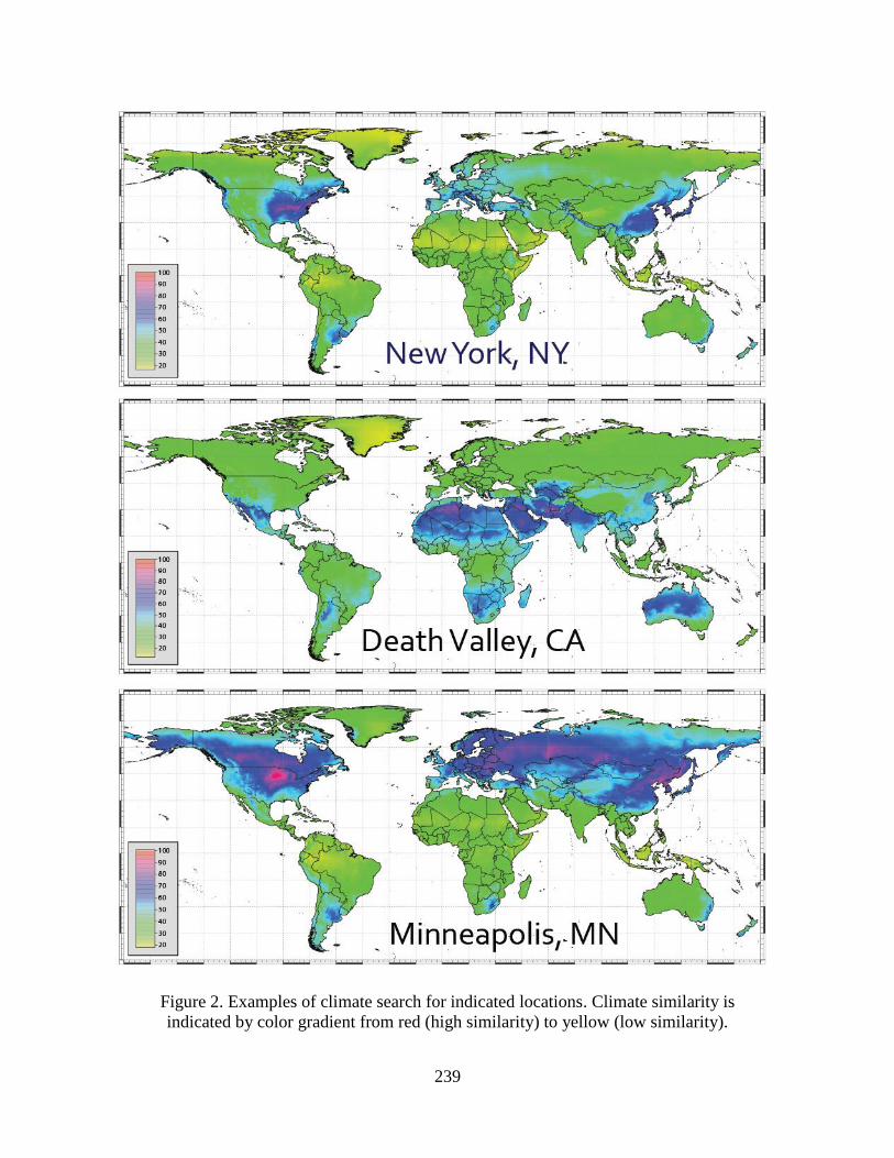
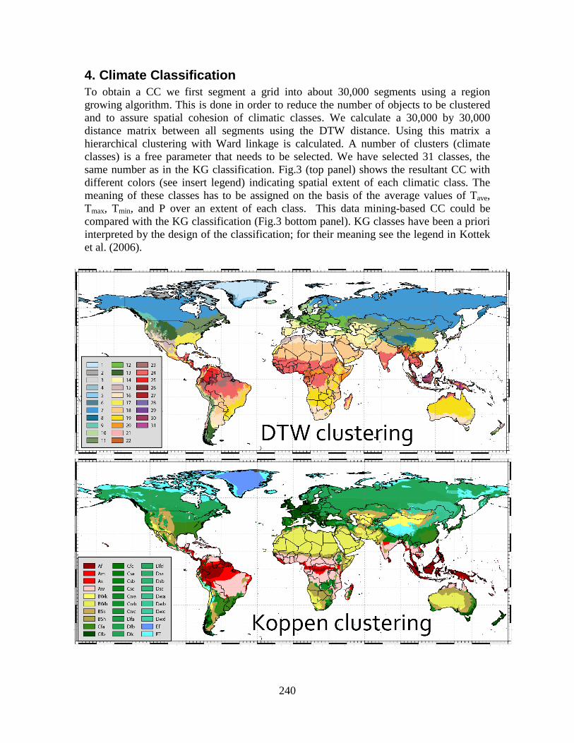
237 World climate search and classification using dynamic time warping similarity function P. Netzel, T. F. Stepinski Space Informatics Lab, Department of Geography, University of Cincinnati, Cincinnati, OH 45221-0131, USA Telephone: +1 513 .556.3583 Fax: +1 513.556.3370 Email: [email protected], [email protected]Abstract We present a data-mining approach to climate classification. Local climates are represented as time series of climatic variables and a similarity between two local climates is calculated using the dynamic time warping (DTW) function which allows for scaling and shifting of the time axis to model the similarity more appropriately than the Euclidean function. A 30 arc second resolution global grid of climatic data is clustered into 31 climatic classes and the resultant world-wide map of climate types is compared to the empirical Köppen–Geiger classification. We also present a concept of climate search – an interactive, internet-based application that allows retrieval and mapping of world- wide locations having climates similar to a user-selected location query. Keywords: climate classification; dynamic time warping; climate search; clustering; segmentation. 1. Introduction Climate classification (CC) schemes discretize the local Earth land surface climatic properties to enable an assessment of global climate models, to help in identification of ecologically similar regions across continents, and to analyze global issues in hydrology, agriculture, and biology. Classical CCs such as the Köppen–Geiger (KG) approach (Kottek et al. 2006) rely on heuristic decision rules reflecting a body of environmental and geographical research, but they appear rather arbitrary from a modern, data-oriented perspective. Data-mining approach to CC reveals inherent spatial patterns in global distribution of climatic variables by means of unsupervised regionalization (spatial classification) – a process that divides the land surface into regions in a way that maximizes intra-region homogeneity and inter-region heterogeneity. Previous applications of unsupervised regionalization to CC (Zscheischler et al. 2012, Metzger et al. 2012) relied on the following set of techniques: representing local climates by vectors of climatic variables, using Euclidean distance to calculate dissimilarity between local climates, and using clustering in data space in lieu of regionalization. Each of these techniques is not an optimal approach to the problem of CC. Here we present a data mining approach to CC that uses a different, more appropriate set of techniques: local climates represented as 12-months-long time series, dissimilarity between local climates measured by the Dynamic Time Warping (DTW) distance (Berndt and Clifford, 1994), and grid segmentation as the means of regionalization. In addition, we introduce a
Transcript
237
World climate search and classification using dynamic time warping similarity function
P. Netzel, T. F. Stepinski
Space Informatics Lab, Department of Geography, University of Cincinnati, Cincinnati, OH 45221-0131, USA


![UrinaryExcretionofCyanidinGlucosides …downloads.hindawi.com/journals/bmri/2004/903824.pdf · [10] Bitsch I, Janssen M, Netzel M, Strass G, Frank T. Bioavailability of anthocyanidin-3-glycosides](https://static.documents.pub/doc/80x56/5f405605245d474ffd2cd9ae/urinaryexcretionofcyanidinglucosides-10-bitsch-i-janssen-m-netzel-m-strass.jpg)


