52
World StreetPro 2017 Product Guide

World StreetPro2017
Product Guide

Information in this document is subject to change without notice and does not represent a commitment on the part of the vendor or its representatives. No part of this document may be reproduced or transmitted in any form or by any means, electronic or mechanical, including photocopying without the written permission of Pitney Bowes Software Inc.
© 2017 Pitney Bowes Limited. All rights reserved. MapInfo®, MapInfo Professional®, and MapXtreme® are registered trademarks of Pitney Bowes Limited and/or its affiliates.
Products named herein may be trademarks of their respective manufacturers and are hereby recognised. Trademarked names are used editorially, to the benefit of the trademark owner, with no intent to infringe on the trademark. Adobe Acrobat® is a registered trademark of Adobe Systems.
© 2006-2017 TomTom. All rights reserved. This material is proprietary and the subject of copyright protection, database right protection andother intellectual property rights owned by TomTom or its suppliers. The use of this material is subject to the terms of a license agreement.Any unauthorized copying or disclosure of this material will lead to criminal and civil liabilities.
• for TomTom® MultiNet® data of Austria: "© BEV, GZ 1368/2003".• for TomTom® MultiNet® data of Denmark: "© DAV, violation of these copyrights shall cause legal proceedings."• for TomTom® MultiNet® data of France: "© IGN France." "Georoute © IGN France.", "Michelin data © Michelin 2009."• for TomTom® MultiNet® data of Northern Ireland: "Ordnance Survey of Northern Ireland.”• for TomTom® MultiNet® data of Norway: "© Norwegian Mapping Authority, Public Roads Administration / ©Mapsolutions.”• for TomTom® MultiNet® data of Russia: "© Roskartographia".• forTomTom® MultiNet® data of Switzerland: "© Swisstopo."• for TomTom® MultiNet® data of The Netherlands: "Topografische onderground Copyright © dienst voor het kadaster en de openbare registers, Apeldoorn 2006."for TomTom® MultiNet® data of the United Kingdom (excluding Northern Ireland):•This product includes mapping data licensed from Ordnance Survey with the permissionof the Controller of Her Maesty’s Stationery Office. © Crown copyright and/or database right 20nn. All rights reserved. Licence number 00026920.”
•UK TMC codes: "The RDS-TMC traffic information with TMC location table version number (6G) 3.4, 4.5 and 4.6 from ITIS contained in this product is derived of the ITIS TMC location table and is subject to the terms of limitation or exclusion of liability of the license agreement between TomTom and ITIS. Usage of this TMC table is subject to contract to be made.
LICENSEThe product is supplied under the terms and conditions specified in the separate Licence Agreement(s). Failure to comply with the terms and conditions may lead to the termination of the licence(s). Customers wishing to install or copy the Data onto more than one computer should apply for a Multi-user Licence. Customers wishing to provide a bureau service for others or to use the Data for the benefit of or on behalf of any others should apply for a Bureau Licence or a Special Licence.Pitney Bowes is making Adobe Acrobat® Reader (the "Software") available to you as a convenience to allow you to easily view and print the documentation in .pdf file format. This should not be construed as an endorsement of Adobe Systems Incorporated or its products. Use of the Software is governed by the terms and conditions of the end user license agreement which is included in the Software. Pitney Bowes makes no representations or warranties, express or implied, with respect to the accuracy, reliability or completeness of the Software. The entire risk as to the use of the Software is assumed by you. In no event shall Pitney Bowes be liable to you or any other person, regardless of the cause, for the effectiveness or accuracy of the Software

or for any special, indirect, incidental or consequential damages arising from or occasioned by your use of the Software, even if advised of the possibility of such damages.Further Information
Pitney Bowes Software Inc. 350 Jordan Rd, Troy, NY 12180 USATelephone: 800.327.8627Email: [email protected]: http://www.pitneybowes.com/usAugust 2017

Table of Contents
Table of Contents
Pitney Bowes 4 August 2017
1 - Product Overview 5
MapInfo Professional Workspace 6Spectrum Spatial (MapXtreme) Workspace 8
2 - Getting Started 9
Compatible Software 10File Names 10Installing World StreetPro 10Opening World StreetPro in MapInfo Professional 11Using Workspaces 11Installation Structure (Collapsed) 12
3 - Data & Table Descriptions 13
File Names and Workspace Aliases 14World StreetPro Mapping Contents 15Display Characteristics and Table Structure 16
Administrative Boundaries 16Ferry Routes 17Gazetteer Layers 18Landuse 20Railways 21Services 22Street Layers 23Urban Areas 24Waterbodies (waterbodies_xx.*)25
4 - Mapping Basics using MapInfo Professional 26
Managing World StreetPro Tables using Layer Control 27
Opening the Layer Control Dialog 27Changing the Display Style of a Map Layer 29Labelling Features and Changing Label Settings 30
Changing Label Settings 30Saving Labels and Label Settings 31
Finding Information 31Setting Spatial Referencing 31
5 - Editing World StreetPro in MapInfo Professional 33
Before you Start 34General Editing Procedures 34Changing the Fill Patterns of Boundaries 34Reshaping Boundaries or Streets 35Changing Point Symbols 35
A - Abbreviations 36

World StreetPro 2017 Product Guide
Pitney Bowes 5 August 2017

1 – Product Overview1
This product guide contains details of Pitney Bowes intermediate level mapping solution - World StreetPro.
In this chapter
Features 6
World StreetPro Product Guide
FeaturesWorld StreetPro is an intermediate level (nominally 1:500,000 scale) digital map base for
Pitney Bowes 6 August 2017
graphic output, and backdrop mapping. It includes roads, railways, international and administrative boundaries, urban areas, coastlines, waterbodies, land cover, gazetteers and more. World StreetPro can be used seamlessly with other parts of the Pitney Bowes’ Data portfolio to achieve robust solutions.
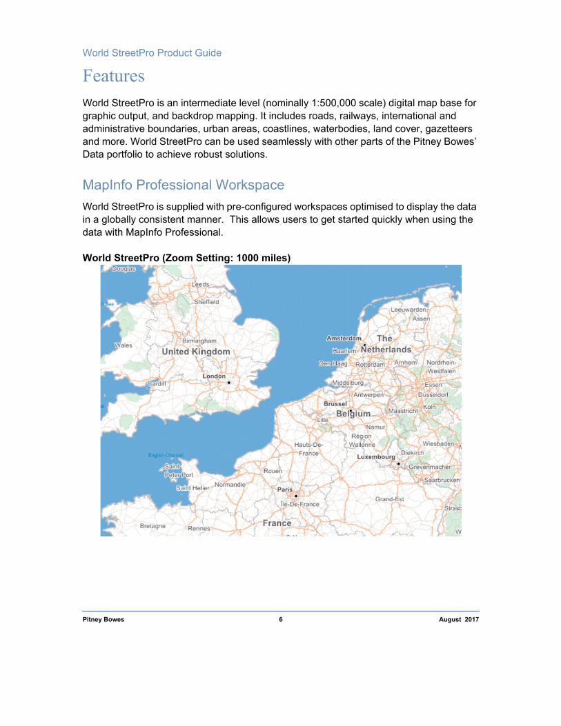
MapInfo Professional WorkspaceWorld StreetPro is supplied with pre-configured workspaces optimised to display the data in a globally consistent manner. This allows users to get started quickly when using the data with MapInfo Professional.
World StreetPro (Zoom Setting: 1000 miles)

1 – Product Overview
World StreetPro (Zoom Setting: 500 miles)
Pitney Bowes 7 August 2017
If you do not purchase updates, your database may cease to reflect the current features.
World StreetPro Product Guide
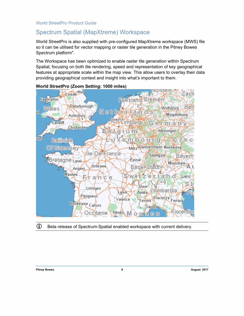
Spectrum Spatial (MapXtreme) WorkspaceWorld StreetPro is also supplied with pre-configured MapXtreme workspace (MWS) file
Pitney Bowes 8 August 2017
so it can be utilised for vector mapping or raster tile generation in the Pitney Bowes Spectrum platform".
The Workspace has been optimized to enable raster tile generation within Spectrum Spatial; focusing on both tile rendering, speed and representation of key geographical features at appropriate scale within the map view. This allow users to overlay their data providing geographical context and insight into what’s important to them.
World StreetPro (Zoom Setting: 1000 miles)
Beta release of Spectrum-Spatial enabled workspace with current delivery.

2 – Getting Started2
This chapter provides useful information to get you started with World StreetPro. You will find file structures, installation instructions,
information about workspaces and project files, procedures for opening feature layers, and spatial referencing tables.In this chapter
Compatible Software 10File Names 10Installing World StreetPro 10Opening World StreetPro in MapInfo Professional 11Using Workspaces 11Installation Structure (Collapsed) 12
World StreetPro Product Guide
Compatible SoftwareWorld StreetPro is optimised to work with MapInfo Professional, MapXtreme and
Pitney Bowes 10 August 2017
Spectrum Spatial Software.
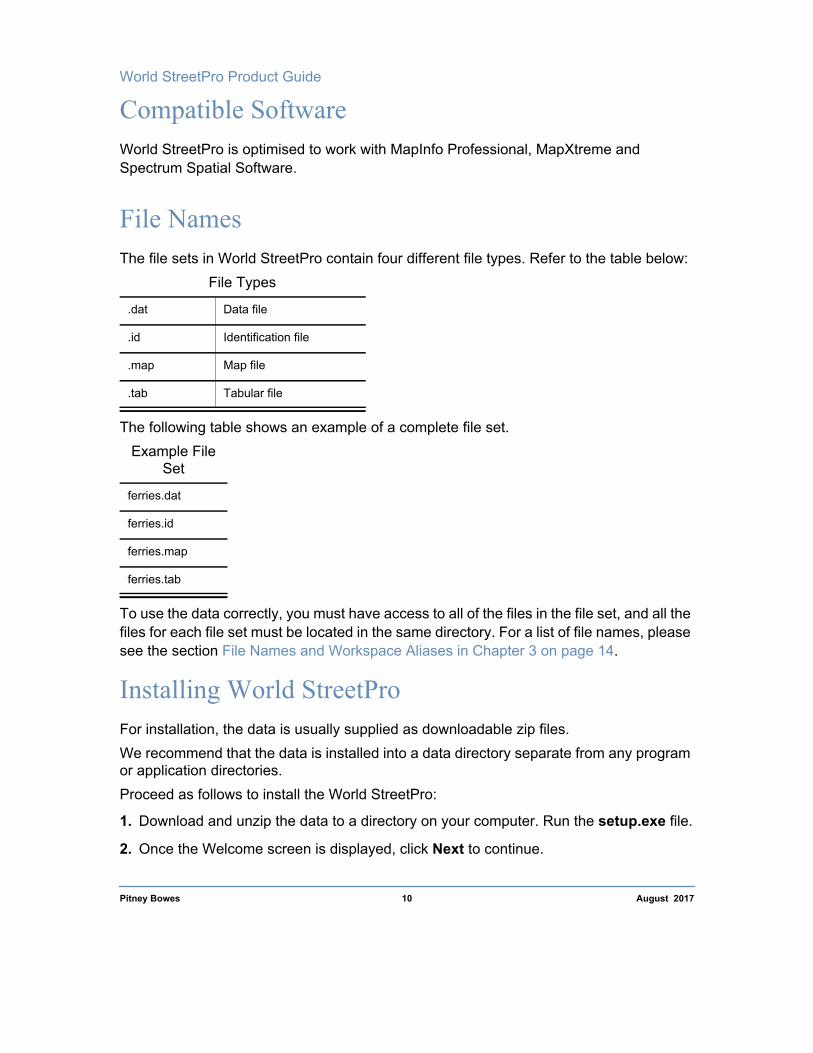
File NamesThe file sets in World StreetPro contain four different file types. Refer to the table below:
The following table shows an example of a complete file set.
To use the data correctly, you must have access to all of the files in the file set, and all the files for each file set must be located in the same directory. For a list of file names, please see the section File Names and Workspace Aliases in Chapter 3 on page 14.
Installing World StreetProFor installation, the data is usually supplied as downloadable zip files.We recommend that the data is installed into a data directory separate from any program or application directories.Proceed as follows to install the World StreetPro:
1. Download and unzip the data to a directory on your computer. Run the setup.exe file.
2. Once the Welcome screen is displayed, click Next to continue.
File Types
.dat Data file
.id Identification file
.map Map file
.tab Tabular file
Example File Set
ferries.dat
ferries.id
ferries.map
ferries.tab

2 – Getting Started
3. Read the License Agreement, and, provided only that you accept all the terms and conditions, click “I accept the agreement”, followed by Next.
Pitney Bowes 11 August 2017
4. Either accept the default destination location or click Browse to select a different folder (which must be on a local drive).
5. Click the Install button if you wish to proceed. Otherwise, click Back to change the folder, before proceeding.
6. Allow the installer to finish running. Once the installation is complete, you will be prompted to click Finish, in order to exit Setup. There is no need to restart the computer.
Opening World StreetPro in MapInfo ProfessionalTo open and display your World StreetPro maps in MapInfo Professional, do one of the following:
• Use File > Open and select files of type MapInfo (*.tab) to open tables individually.
Or
• Use File > Open, select files of type Workspace (*.wor and .mws), and open the required workspace - the multiple tables associated with the selected workspace are opened automatically.
Using WorkspacesTo help users get up and running quickly, Pitney Bowes provide workspace files that are optimized to show the data at multiple zoom levels. For information about overriding the details, please refer Chapter 4 Mapping Basics using MapInfo Professional.
Where supplied, these workspaces use the following naming conventions: WOR files for use with MapInfo Professional (wsp_continent-name*.wor), or MWS files for use with Mapxtreme and Spectrum Spatial (wsp_continent-name*.mws).
*continent-name: Africa, Asia, Europe, North America or South America.

World StreetPro Product Guide
Installation Structure (Collapsed)Following installation, the directory structure shown overleaf should have been
Pitney Bowes 12 August 2017
automatically created in the selected location.
...pitneybowesdata\streetpro\world\year\continentname
_basemaps folder contains:
• World and Ocean tables• Marine Labels • miCodemaster table
data folder contains:
• MapInfo Professional 15.x (*.wor)• Spectrum Spatial (*.mws)• Data layers
_docs folder contains:
• World StreetPro Stub PDF (Contains a link for the Product Guide and Release Notes)
• License Document
_metadata folder contains:
• Metadata xml and Stylesheet

3 – Data & Table Descriptions3
This chapter provides information on the feature layers included with World StreetPro, including spatial referencing, file names, display
characteristics, table structure, and feature codes.In this chapter
Default Spatial Referencing 14File Names and Workspace Aliases 14World StreetPro Mapping Contents 15
15

World StreetPro Product Guide
Default Spatial ReferencingBy default, the World StreetPro database uses the projection and coordinates listed in the
Pitney Bowes 14 August 2017
table below. For more information about spatial referencing, please refer to Chapter 4 Mapping Basics using MapInfo Professional.
File Names and Workspace AliasesThe table below contains the file names and workspace aliases for each table in World StreetPro. Information about the display characteristics and table structure of each layer is available in the following section under each table’s folder. To access this information directly from this table, click the table name. The tables are listed in alphabetical order.
Coordinate System Longitude/Latitude (WGS84)
Coordinate Units Decimal degrees
Projection Longitude/Latitude
Table NameWorkspace
Alias Table Description
admin_a0_xx.* Admin_Level0 Administrative Level 0 Boundaries
admin_a1_xx.* Admin_Level1 Administrative Level 1 Boundaries
admin_a2_xx.* Admin_Level2 Administrative Level 2 Boundaries
services_xx.* Services Airports, Ferry and Stations points
capital_city_xx.* Capital_City Capital Cities
ferries_xx.* Ferries Ferries
landuse_xx.* Land Use Land Use (includes park only)
major_city_xx.* Major_City Major Cities
major_town_xx.* Major_Town Major Towns
waterbodies_xx.* Waterbodies Major Waterbodies (includes Lakes and Rivers)
_basemaps\ocean.* Ocean Ocean
railways_xx.* Railways Railways

3 – Data & Table Descriptions
street_s1_xx.* Street_Level1 Street Network - Motorways
street_s2_xx.* Street_Level2 Streets Network - Main Roads
Pitney Bowes 15 August 2017
Note: * refers to all layer files (dat, id, map and tab)xx represents continent name (for country specific data cuts, xx is replaced by ISO3 counrtry code)
For the global product "xx" would be written as same with the table name, it would not be replaced by any continent code. Where the product is supplied at continent level the "xx" represents the relevant 2 letter continent code viz. af (Africa); as (Asia); eu (Europe) – Split into *_e1 (Eastern Europe) and *_e2 (Western Europe); am (America); na (North America); sa (South America).
World StreetPro Mapping ContentsWorld StreetPro contains the feature layers listed below. Information about each layer is available in the sections that follow the list, where the tables are organised by the continent folders into which they are grouped on the product media. To access the accompanying information directly from the list below, click the hyperlink following the appropriate bullet:
• Administrative Boundaries Ferry Routes ( ferries_xx.*)• Gazetteer Layers• Railways (railways_xx.*)• Services (services_xx.*)• Street Layers (street_level1_xx.* - street_level3_xx.*)• Urban Areas ( urban_xx.*)
street_s3_xx.* Street_Level3 Street Network - Other Major Roads
town_xx.* Town Towns
urban_xx.* Urban Urban Areas
_basemaps\wrlda0.* World World Layer

World StreetPro Product Guide
Display Characteristics and Table StructureThis section contains technical information about the display characteristics and table
Pitney Bowes 16 August 2017
structure of each feature layer.
Administrative BoundariesThe Administrative Layers represents the administrative geography used by each country.
Administrative 0 admin_a0_xx.*
The admin_a0 layer contains the national or international boundaries.
Display Characteristics
Administrative 1 admin_a1_xx.*
The admin_a1 represents State or its equivalent boundaries.
Display Characteristics
Administrative 2 admin_a2_xx.*
The admin_a2 contains Counties or its equivalent boundaries of the countrty.
miCode Feature Style Graphic Object Details
50010100 Admin Level 0 boundaries (Country)
Brush (1, 0, 16777215)! Pen (15, 2, 11381932)
miCode Feature Style Graphic Object Details
50010101 Admin Level 1 boundaries
Brush (1, 0, 16777215)! Pen (15, 2, 11381932)

3 – Data & Table Descriptions
Display Characteristics
miCode Feature Style Graphic Object Details
Pitney Bowes 17 August 2017
Table Structure
Ferry Routes (ferries_xx.*)The Ferry Routes table contains ferry connections classified by mode of operation.
Display Characteristics
50010102 Admin Level 2 boundaries
Brush (1, 0, 16777215)! Pen (1, 7,15987181)
Field Description Type (Width)
Name Name of Feature Char (100)
Name_Lng ISO 3 Character Language code Char (3)
miCode PB Feature Code Integer
SmartLabel Same as Name with added carriage returns Char (100)
FeatureID Unique Feature Identifier Decimal (17,0)
ISO3 Three letter Country Code defined in ISO 3166-1
Char (3)
Country Name of country Char (50)
miCode Feature Style Graphic Object Details
70010100 Ferry, operated by ship/hovercraft
Pen (1,9,4227327)
70020100 Ferry, operated by train
Pen (1,9,0)
70010110 Vehicular Ferry Pen (1,9,4227327)
70010120 Passenger Ferry Pen (1,9,4227327)

World StreetPro Product Guide
Table Structure
Field Description Type (Width)
Pitney Bowes 18 August 2017
Gazetteer LayersThe gazetteer layers contain points for country capitals through to towns.
Capital City capital_city_xx.*Display Characteristics
Name Name of Feature Char (100)
Name_Lng ISO 3 Character Language code Char (3)
miCode PB Feature Code Integer
SmartLabel Same as Name with added carriage returns Char (100)
FeatureID Unique Feature Identifier Decimal (17,0)
ISO3 Three letter Country Code defined in ISO 3166-1
Char (3)
Country Name of country Char (50)
miCode Feature Style Graphic Object Details
80010200 Capital Cities Symbol (61,13697024,10,"MapInfo Cartographic",256,0)

3 – Data & Table Descriptions
Major City major_city_xx.*
Display Characteristics
Pitney Bowes 19 August 2017
Major Town major_town_xx.*
Display Characteristics
Town town_xx.*
Display Characteristics
Table Structure
miCode Feature Style Graphic Object Details
80020101 Major City Symbol (47,0,9,"MapInfo Cartographic",256,0)
miCode Feature Style Graphic Object Details
80020102 City or major town Symbol (46,0,7,"MapInfo Cartographic",256,0)
miCode Feature Style Graphic Object Details
80020103 Town Symbol
Symbol (34, 16777215, 6)
Field Description Type (Width)
Name Name of Feature Char (100)
Name_Lng ISO 3 Character Language code Char (3)
miCode PB Feature Code Integer
SmartLabel Same as Name with added carriage returns Char (100)
FeatureID Unique Feature Identifier Decimal (17,0)
ISO3 Three letter Country Code defined in ISO 3166-1
Char (3)
Country Name of country Char (50)

World StreetPro Product Guide
Landuse (landuse_xx.*)The land use table contains region objects representing city parks, national and regional
Pitney Bowes 20 August 2017
parks.
Display Characteristics
Table Structure
miCode Feature Style Graphic Object Details
60010110 Regional Park Brush (2, 11592127)!Pen (1, 2, 11592127)
60010111 National Park Brush (2, 11592127)! Pen (1, 2, 11592127)
60010112 State or Province Park
Brush (2, 11592127)!Pen (1, 2, 11592127)
60010113 County Park Brush (2, 11592127)! Pen (1, 2, 11592127)
60010120 National / Regional Marine Park
Brush (2, 11592127)! Pen (1, 2, 11592127)
Field Description Type (Width)
Name Name of Feature Char (150)
Name_Lng ISO 3 Character Language code Char (3)
miCode PB Feature Code Integer
SmartLabel Same as Name with added carriage returns Char (150)
FeatureID Unique Feature Identifier Decimal (17,0)
ISO3 Three letter Country Code defined in ISO 3166-1
Char (3)
Country Name of country Char (50)
Feature Description
Feature type description Char (50)
Category Feature category defined for spectrum spatial thematic
Char (50)
3 – Data & Table Descriptions
Importance Feature category importance – Integer
Field Description Type (Width)
Pitney Bowes 21 August 2017
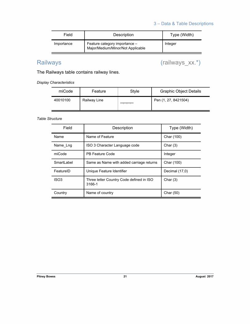
Railways (railways_xx.*)The Railways table contains railway lines.
Display Characteristics
Table Structure
Major/Medium/Minor/Not Applicable
miCode Feature Style Graphic Object Details
40010100 Railway Line Pen (1, 27, 8421504)
Field Description Type (Width)
Name Name of Feature Char (100)
Name_Lng ISO 3 Character Language code Char (3)
miCode PB Feature Code Integer
SmartLabel Same as Name with added carriage returns Char (100)
FeatureID Unique Feature Identifier Decimal (17,0)
ISO3 Three letter Country Code defined in ISO 3166-1
Char (3)
Country Name of country Char (50)

World StreetPro Product Guide
Services (services_xx.*)The services layer contains airport locations, railway stations (national/ regional) and ferry
Pitney Bowes 22 August 2017
stations.
Display Characteristics
miCode Feature Style Graphic Object Details
10310101 Airport Public Symbol(72,4474083,14,"MapInfo Real Estate",257,0)
10320101 Ferry Terminal ship/hovercraft
Symbol (98,22015,14,"MapInfo Transportation",256,0)
10320102 Ferry Terminal Train Symbol (109,132,16,"MapInfo Transportation",256,0)
10320202 Railway station, International
Symbol (110,6316128,18,"MapInfo Transportation",256,0)
10320203 Railway station, National
Symbol (110,6316128,18,"MapInfo Transportation",256,0)

3 – Data & Table Descriptions
Table Structure
Field Description Type (Width)
Pitney Bowes 23 August 2017
Street Layers (street_level1_xx.* - street_level3_xx.*)The street layers contain motorways, major, minor and secondary roads. Roads of major network importance are held in the Street 1 layer, with subsequent layers containing streets in decreasing order of importance.
Display Characteristics
Table Structure
Name Name of Feature Char (100)
Name_Lng ISO 3 Character Language code Char (3)
miCode PB Feature Code Integer
SmartLabel Same as Name with added carriage returns Char (100)
FeatureID Unique Feature Identifier Decimal (17,0)
ISO3 Three letter Country Code defined in ISO 3166-1
Char (3)
Country Name of country Char (50)
Category Feature Category Description Char (50)
SubCategory Feature Sub- Category Description Char (100)
miCode Feature Style Graphic Object Details
20010100 Motorways Pen (25, 2, 13794428)
20020100 Main Roads Pen (25, 2, 8762781)
20030100 Other Major Roads Pen (25, 2, 8762781)
Field Description Type (Width)
Road_No Road number Character (15)
Road_Name Name of feature Character (100)

World StreetPro Product Guide
Road_Nm_Lng ISO 3 Character Language code Character (3)
Field Description Type (Width)
Pitney Bowes 24 August 2017
Urban Areas (urban_xx.*)The Urban Areas table contains region objects that represent majour built-up areas.
Display Characteristics
Table Structure
miCode PB Feature Code Integer
FeatureID Unique Feature Identifier Decimal (17,0)
ISO3 Three letter Country Code defined in ISO 3166-1
Char (3)
Country Name of country Char (50)
miCode Feature Style Graphic Object Details
50040200 Urban Centers Brush (2, 14737632,16777215)! Pen (1, 2, 14737632)
Field Description Type (Width)
Name Name of Feature Char (100)
Name_Lng ISO 3 Character Language code Char (3)
miCode PB Feature Code Integer
SmartLabel Same as Name with added carriage returns Char (100)
FeatureID Unique Feature Identifier Decimal (17,0)
ISO3 Three letter Country Code defined in ISO 3166-1
Char (3)
Country Name of country Char (50)

3 – Data & Table Descriptions
Waterbodies (waterbodies_xx.*)The Waterbodies table contains region objects that represent rivers and lakes.
Pitney Bowes 25 August 2017
Display Characteristics
Table Structure
miCode Feature Style Graphic Object Details
30030100 Water feature, lake Brush(2,11130623,16777215)! Pen(1,2,11130623)
30030302 Water feature, rivers
Brush(2,11130623,16777215)! Pen(1,2,11130623)
30050800 Water Intermittent waterbodies
Brush(2,11130623,16777215)! Pen(1,2,11130623)
Field Description Type (Width)
Name Name of Feature Char (100)
Name_Lng ISO 3 Character Language code Char (3)
miCode PB Feature Code Integer
SmartLabel Same as Name with added carriage returns Char (100)
FeatureID Unique Feature Identifier Decimal (17,0)
ISO3 Three letter Country Code defined in ISO 3166-1
Char (3)
Country Name of country Char (50)
Display_Class Water Display Class (Class 1 [Highest] and 2 [Lowest])
Char (50)
Display_Type Water Feature Type (Rivers; Lake; Others Waterbodies)
Integer
Feature_Desc Feature Category Description Char (50)

World StreetPro Product Guide
Pitney Bowes 26 August 2017

4 – Mapping Basics using MapInfo Professional
4
This chapter provides instructions on several basic tasks that you are likely to perform with World StreetPro data, including managing layers in a workspace, changing display styles, labelling features, finding information, and setting spatial referencing.These topics are covered in more detail in the MapInfo Professional documentation set. This Chapter is not updated frequently. For complete and updated information, refer the MapInfo Professional Documentation.
In this chapter
Managing World StreetPro Tables using Layer Control 27Changing the Display Style of a Map Layer 29Labelling Features and Changing Label Settings 30Finding Information 31Setting Spatial Referencing 31

World StreetPro Product Guide
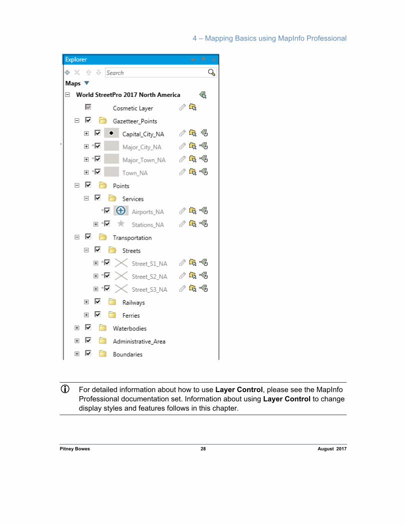
Managing World StreetPro Tables using Layer Control
Pitney Bowes 27 August 2017
In Chapter 2 Getting Started, we explained how to open multiple tables automatically in workspaces. Each table opens in the workspace as a separate layer in the map window. For example, motorways are displayed in a layer called street_s1_xx, and point object railway stations are displayed in a layer called services_xx.
Each layer is displayed with preset label, zoom and display settings. You can use Layer Control (Explorer if MapInfo Professional 64 bit is installed) to override the predetermined settings and control other aspects of the workspace, for example to:
• Remove layers from the map window without closing the tables;• Add layers to the map window;• Change how the layers look while they are displayed in the map window;• Set the labeling conditions for each layer;• Set whether a layer is visible, editable, selectable, or labelled;• Set the zoom level so that local features are displayed only when you are close
enough to see the detail;• Re-order the layers to hide or expose other map features.
Opening the Layer Control DialogAccess the Layer Control dialog by doing one of the following:
• Select Map > Layer Control (Explorer if MapInfo Professional 64 bit is installed) from the MapInfo Professional menu bar.
• Right-click in a map window and choose Layer Control from the popup menu.
• Click the Layer Control button on the Main toolbar.
The following dialog is displayed:
4 – Mapping Basics using MapInfo Professional
Pitney Bowes 28 August 2017
.
For detailed information about how to use Layer Control, please see the MapInfo Professional documentation set. Information about using Layer Control to change display styles and features follows in this chapter.
World StreetPro Product Guide
Changing the Display Style of a Map LayerWhether you have opened a layer individually or in a workspace, you can temporarily
Pitney Bowes 29 August 2017
change its display settings using the Layer Control (Explorer if MapInfo Professional 64 bit is installed) dialog:
1. Proceed as in Opening the Layer Control Dialog on page 27.
2. Click on the layer you want to change in order to highlight it.
3. Click the Display button to bring up the Display Options dialog:
4. Make any changes to the settings in the Zoom Layering panel.
5. Select the Style Override check box to activate the map feature display button.
6. Click the map feature display button. The Symbol Style dialog is displayed.
7. Make any changes to the settings in the style dialog.
8. Click OK to return to the Display Options dialog.
9. Click OK to return to the Layer Control dialog. Click OK again to return to the map window.
10.The map window is redrawn, displaying your changes.

4 – Mapping Basics using MapInfo Professional
Labelling Features and Changing Label Settings
Pitney Bowes 30 August 2017
You can label features one at a time using the MapInfo Professional Label tool . By default, MapInfo Professional labels the topmost feature, but you can label other features by holding down the Ctrl key while you click.
To label an entire layer at once, use Layer Control. To do this, follow the instructions below.
1. Proceed as in Opening the Layer Control Dialog on page 27.
2. Click the Label check box next to the layer that you wish to label.
3. Click OK.
The map window is redrawn, displaying labels for the features in the layer that you chose to label.
Changing Label SettingsMapInfo Professional’s Label feature starts with preset characteristics. To alter these settings, follow the instructions below.
1. Proceed as in Opening the Layer Control Dialog on page 27.
2. Click on the layer you want to change. It is highlighted.
3. Click the Label button. The Label Options dialog is displayed.
4. Make the desired changes and click OK to return to the Layer Control dialog.
5. Ensure that the label box is checked if you want to automatically label the entire layer.
6. Click OK.
The map window is redrawn, displaying labels for the features in the layer that you chose to label.
To change the attributes of a single label, double-click it using the MapInfo Professional Select tool. The Label Style dialog appears. Make the necessary changes and click OK.

World StreetPro Product Guide
Saving Labels and Label SettingsTo save the labels and label settings, select File > Save Workspace. The labels and any
Pitney Bowes 31 August 2017
other changes you may have made will be saved collectively as a workspace.
Finding InformationAnother basic advantage of using maps with World StreetPro is the ability to find information about a feature.
The easiest way to do this is to click on the feature using the Information tool - information about every map object at that point is displayed in the Information Tool window.
If there is more than one object listed in the window, click on the name of the feature in the window to view all the information associated with the object.
Setting Spatial ReferencingThe map layers in World StreetPro come with the preset spatial referencing detailed in Chapter 3 Data & Table Descriptions.
You may change this spatial referencing to match the spatial referencing system of your own data. To do this, follow the instructions below.
1. Open a World StreetPro table or workspace in MapInfo Professional.
2. Select File > Save Copy As, to bring up the Save Copy As dialog.
3. Choose the table for which you want to change the projection and click the Save As button. The Save Copy of Table As dialog is displayed.
4. Either choose a new name and/or directory for the table, or leave the table name and directory the same to overwrite the table with a new projection.
5. Click the Projection button. The following dialog appears.

4 – Mapping Basics using MapInfo Professional
Pitney Bowes 32 August 2017
.
6. Choose a new Category and then select a Category Member.
7. Click OK. You are returned to the previous dialog.
8. Click Save.
Your map is redrawn showing the new spatial referencing settings. The changes are permanently saved to the table.

World StreetPro Product Guide
Pitney Bowes 33 August 2017

5 – Editing World StreetPro in MapInfo Professional
5
With MapInfo Professional, you can change line styles, add and delete features, modify table structures, reshape streets, change names, and much more. This chapter explains how to edit World StreetPro map layers.These topics are covered in more detail in the MapInfo Professional documentation set. For complete and updated information, refer the MapInfo Professional documentation.
In this chapter:
Before you Start 34General Editing Procedures 34Changing the Fill Patterns of Boundaries 34Reshaping Boundaries or Streets 35Changing Point Symbols 35

World StreetPro Product Guide
Before you Start
Pitney Bowes 34 August 2017
You can only edit one table at a time. It is a good idea to save a backup copy of your data before making any changes.
General Editing ProceduresTo edit a World StreetPro map layer, follow the instructions below:
1. Proceed as in Opening the Layer Control Dialog in Chapter 4 on page 27.
2. Select the Editable check box (pencil icon) of the layer that you wish to modify.
3. Click OK.
The Drawing Tools in the Toolbar become active and you are ready to make changes to the layer.
For more information on using the editing tools, refer to your MapInfo Professional Online Help.
Changing the Fill Patterns of BoundariesTo permanently change the colour or fill pattern of a boundary:
1. Select the boundary.
2. Select Options > Region Style. The Region Style dialog is displayed.[Note: Select Style > Region Style, if MapInfo Professional 64 bit is installed.]
3. Scroll through the fill and colour palettes to choose the desired colour and fill.
4. Click OK to apply the changes.
To change the fill pattern for the entire layer temporarily, use Layer Control as described in the section Changing the Display Style of a Map Layer in Chapter 4 on page 29”.

5 – Editing World StreetPro in MapInfo Professional
Reshaping Boundaries or StreetsTo reshape a boundary or street:
Pitney Bowes 35 August 2017
1. Select the object.
2. Either select Edit > Reshape or select the Reshape tool .
Nodes (small boxes) appear at every juncture where segments meet.
3. Move or delete existing nodes or add new nodes.
This is particularly useful when boundaries change over time. You can update the data yourself by simply adding, moving, and deleting nodes. For more information, refer to the MapInfo Professional Online Help.
Changing Point SymbolsTo change the symbols of points:
1. Select the point(s) you want to change.
2. Select Options > Symbol Style. The Symbol Style dialog is displayed.[Note: Select Style > Symbol Style, if MapInfo Professional 64 bit is installed.]
3. Scroll through the symbol and colour palettes and choose the desired colour and symbol.
4. Click OK to apply the changes.

World StreetPro Product Guide
Pitney Bowes 36 August 2017

A – Abbreviations
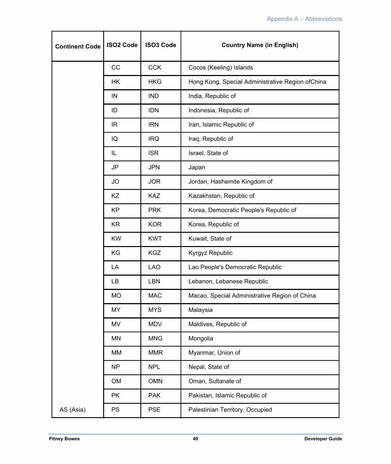
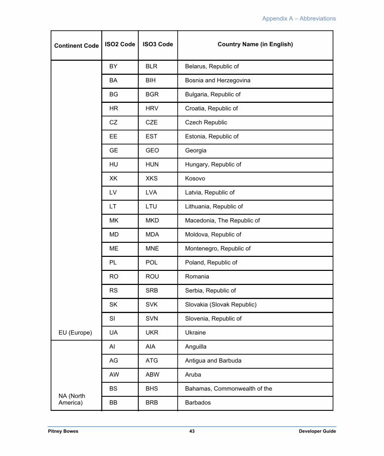
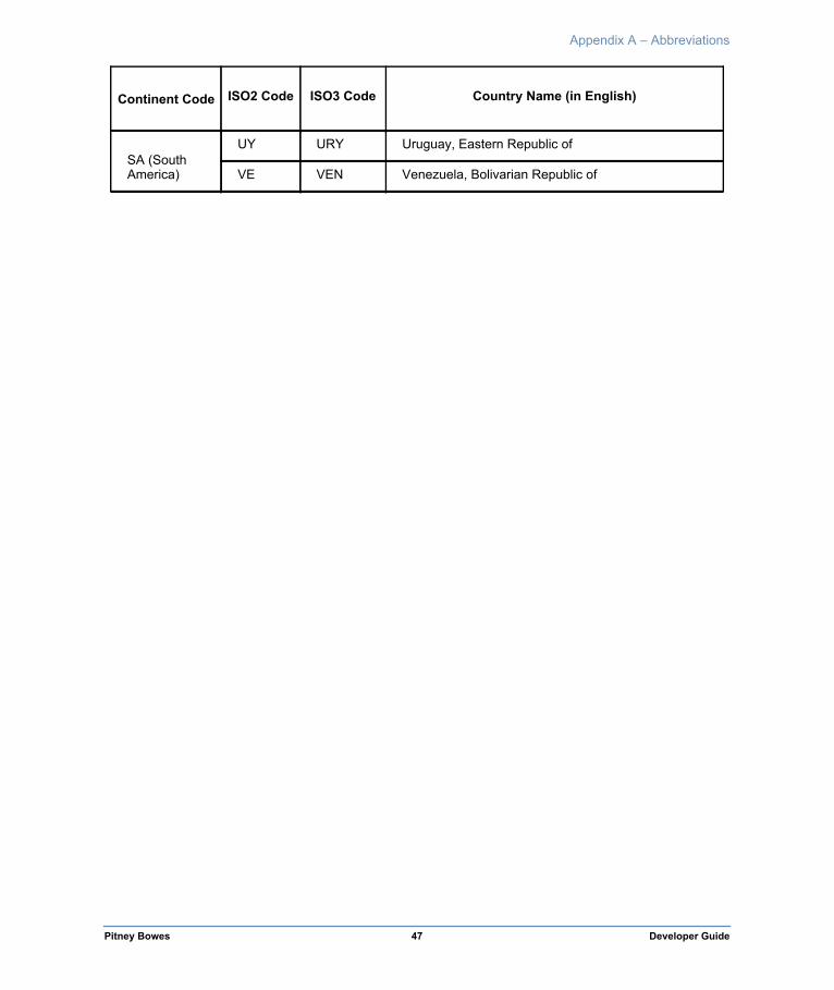
World StreetPro uses the three-character country codes established by International Standard ISO 3166-1: 1997. The ISO 3166-1 alpha-3 codes represent countries, dependent territories, and special areas of geographical interest. They are based on lists of country names from the United Nations and these codes are reproduced in the table overleaf.

Appendix A – Abbreviations
Abbreviations
Continent Code ISO2 Code ISO3 Code Country Name (in English)
AF (Africa)
DZ DZA Algeria, People's Democratic Republic of
AO AGO Angola, Republic of
BJ BEN Benin, Republic of
BW BWA Botswana, Republic of
BF BFA Burkina Faso
BI BDI Burundi, Republic of
CM CMR Cameroon, Republic of
CV CPV Cape Verde, Republic of
CF CAF Central African Republic
TD TCD Chad, Republic of
KM COM Comoros, Union of the
CD COD Congo, Democratic Republic of the
CG COG Congo, Republic of the
CI CIV Cote d'Ivoire, Republic of
DJ DJI Djibouti, Republic of
EG EGY Egypt, Arab Republic of
GQ GNQ Equatorial Guinea, Republic of
ER ERI Eritrea, State of
ET ETH Ethiopia, Federal Democratic Republic of
GA GAB Gabon, Gabonese Republic
GM GMB Gambia, Republic of the
GH GHA Ghana, Republic of
GN GIN Guinea, Republic of
GW GNB Guinea-Bissau, Republic of
Pitney Bowes 37 Developer Guide

Appendix A – Abbreviations
AF (Africa)
KE KEN Kenya, Republic of
LS LSO Lesotho, Kingdom of
LR LBR Liberia, Republic of
LY LBY Libyan Arab Jamahiriya
MG MDG Madagascar, Republic of
MW MWI Malawi, Republic of
ML MLI Mali, Republic of
MR MRT Mauritania, Islamic Republic of
MU MUS Mauritius, Republic of
YT MYT Mayotte
MA MAR Morocco, Kingdom of
MZ MOZ Mozambique, Republic of
NA NAM Namibia, Republic of
NE NER Niger, Republic of
NG NGA Nigeria, Federal Republic of
RE REU Reunion
RW RWA Rwanda, Republic of
SH SHN Saint Helena
ST STP Sao Tome and Principe, Democratic Republicof
SN SEN Senegal, Republic of
SC SYC Seychelles, Republic of
SL SLE Sierra Leone, Republic of
SO SOM Somalia, Somali Republic
ZA ZAF South Africa, Republic of
SS SSD South Sudan
Continent Code ISO2 Code ISO3 Code Country Name (in English)
Pitney Bowes 38 Developer Guide

Appendix A – Abbreviations
AF (Africa)
SD SDN Sudan, Republic of
SZ SWZ Swaziland, Kingdom of
TZ TZA Tanzania, United Republic of
TG TGO Togo, Togolese Republic
TN TUN Tunisia, Tunisian Republic
UG UGA Uganda, Republic of
EH ESH Western Sahara
ZM ZMB Zambia, Republic of
ZW ZWE Zimbabwe, Republic of
AN (Antarctica)
AQ ATA Antarctica (the territory South of 60degS)
BV BVT Bouvet Island (Bouvetoya)
TF ATF French Southern Territories
HM HMD Heard Island and McDonald Islands
GS SGS South Georgia and the South SandwichIslands
AS (Asia)
AF AFG Afghanistan, Islamic Republic of
AM ARM Armenia, Republic of
AZ AZE Azerbaijan, Republic of
BH BHR Bahrain, Kingdom of
BD BGD Bangladesh, People's Republic of
BT BTN Bhutan, Kingdom of
IO IOT British Indian Ocean Territory (Chagos Archipelago)
BN BRN Brunei Darussalam
KH KHM Cambodia, Kingdom of
CN CHN China, People's Republic of
CX CXR Christmas Island
Continent Code ISO2 Code ISO3 Code Country Name (in English)
Pitney Bowes 39 Developer Guide
Appendix A – Abbreviations
AS (Asia)
CC CCK Cocos (Keeling) Islands
HK HKG Hong Kong, Special Administrative Region ofChina
IN IND India, Republic of
ID IDN Indonesia, Republic of
IR IRN Iran, Islamic Republic of
IQ IRQ Iraq, Republic of
IL ISR Israel, State of
JP JPN Japan
JO JOR Jordan, Hashemite Kingdom of
KZ KAZ Kazakhstan, Republic of
KP PRK Korea, Democratic People's Republic of
KR KOR Korea, Republic of
KW KWT Kuwait, State of
KG KGZ Kyrgyz Republic
LA LAO Lao People's Democratic Republic
LB LBN Lebanon, Lebanese Republic
MO MAC Macao, Special Administrative Region of China
MY MYS Malaysia
MV MDV Maldives, Republic of
MN MNG Mongolia
MM MMR Myanmar, Union of
NP NPL Nepal, State of
OM OMN Oman, Sultanate of
PK PAK Pakistan, Islamic Republic of
PS PSE Palestinian Territory, Occupied
Continent Code ISO2 Code ISO3 Code Country Name (in English)
Pitney Bowes 40 Developer Guide

Appendix A – Abbreviations
AS (Asia)
PH PHL Philippines, Republic of the
QA QAT Qatar, State of
RU RUS Russian Federation
SA SAU Saudi Arabia, Kingdom of
SG SGP Singapore, Republic of
LK LKA Sri Lanka, Democratic Socialist Republic of
SY SYR Syrian Arab Republic
TW TWN Taiwan
TJ TJK Tajikistan, Republic of
TH THA Thailand, Kingdom of
TL TLS Timor-Leste, Democratic Republic of
TM TKM Turkmenistan
AE ARE United Arab Emirates
UZ UZB Uzbekistan, Republic of
VN VNM Vietnam, Socialist Republic of
YE YEM Yemen
EU (Europe)
AX ALA Â land Islands
AD AND Andorra, Principality of
AT AUT Austria, Republic of
BE BEL Belgium, Kingdom of
CY CYP Cyprus, Republic of
DK DNK Denmark, Kingdom of
FO FRO Faroe Islands
FI FIN Finland, Republic of
FR FRA France, French Republic
Continent Code ISO2 Code ISO3 Code Country Name (in English)
Pitney Bowes 41 Developer Guide

Appendix A – Abbreviations
EU (Europe)
DE DEU Germany, Federal Republic of
GI GIB Gibraltar
GR GRC Greece, Hellenic Republic
GG GGY Guernsey, Bailiwick of
VA VAT Holy See (Vatican City State)
IS ISL Iceland, Republic of
IE IRL Ireland
IM IMN Isle of Man
IT ITA Italy, Italian Republic
JE JEY Jersey, Bailiwick of
LI LIE Liechtenstein, Principality of
LU LUX Luxembourg, Grand Duchy of
MT MLT Malta, Republic of
MC MCO Monaco, Principality of
NL NLD Netherlands, Kingdom of the
NO NOR Norway, Kingdom of
PT PRT Portugal, Portuguese Republic
SM SMR San Marino, Republic of
ES ESP Spain, Kingdom of
SJ SJM Svalbard & Jan Mayen Islands
SE SWE Sweden, Kingdom of
CH CHE Switzerland, Swiss Confederation
TR TUR Turkey, Republic of
GB GBR United Kingdom of Great Britain &NorthernIreland
EU Europe) AL ALB Albania, Republic of
Continent Code ISO2 Code ISO3 Code Country Name (in English)
Pitney Bowes 42 Developer Guide
Appendix A – Abbreviations
EU (Europe)
BY BLR Belarus, Republic of
BA BIH Bosnia and Herzegovina
BG BGR Bulgaria, Republic of
HR HRV Croatia, Republic of
CZ CZE Czech Republic
EE EST Estonia, Republic of
GE GEO Georgia
HU HUN Hungary, Republic of
XK XKS Kosovo
LV LVA Latvia, Republic of
LT LTU Lithuania, Republic of
MK MKD Macedonia, The Republic of
MD MDA Moldova, Republic of
ME MNE Montenegro, Republic of
PL POL Poland, Republic of
RO ROU Romania
RS SRB Serbia, Republic of
SK SVK Slovakia (Slovak Republic)
SI SVN Slovenia, Republic of
UA UKR Ukraine
NA (North America)
AI AIA Anguilla
AG ATG Antigua and Barbuda
AW ABW Aruba
BS BHS Bahamas, Commonwealth of the
BB BRB Barbados
Continent Code ISO2 Code ISO3 Code Country Name (in English)
Pitney Bowes 43 Developer Guide

Appendix A – Abbreviations
NA (North America)
BZ BLZ Belize
BM BMU Bermuda
BQ BES Bonaire, Sint Eustatius and Saba
VG VGB British Virgin Islands
CA CAN Canada
KY CYM Cayman Islands
CR CRI Costa Rica, Republic of
CU CUB Cuba, Republic of
CW CUW Cura‡ao
DM DMA Dominica, Commonwealth of
DO DOM Dominican Republic
SV SLV El Salvador, Republic of
GL GRL Greenland
GD GRD Grenada
GP GLP Guadeloupe
GT GTM Guatemala, Republic of
HT HTI Haiti, Republic of
HN HND Honduras, Republic of
JM JAM Jamaica
MQ MTQ Martinique
MX MEX Mexico, United Mexican States
MS MSR Montserrat
AN ANT Netherlands Antilles
NI NIC Nicaragua, Republic of
PA PAN Panama, Republic of
Continent Code ISO2 Code ISO3 Code Country Name (in English)
Pitney Bowes 44 Developer Guide
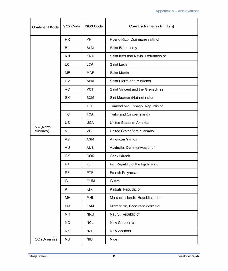
Appendix A – Abbreviations
NA (North America)
PR PRI Puerto Rico, Commonwealth of
BL BLM Saint Barthelemy
KN KNA Saint Kitts and Nevis, Federation of
LC LCA Saint Lucia
MF MAF Saint Martin
PM SPM Saint Pierre and Miquelon
VC VCT Saint Vincent and the Grenadines
SX SXM Sint Maarten (Netherlands)
TT TTO Trinidad and Tobago, Republic of
TC TCA Turks and Caicos Islands
US USA United States of America
VI VIR United States Virgin Islands
OC (Oceania)
AS ASM American Samoa
AU AUS Australia, Commonwealth of
CK COK Cook Islands
FJ FJI Fiji, Republic of the Fiji Islands
PF PYF French Polynesia
GU GUM Guam
KI KIR Kiribati, Republic of
MH MHL Marshall Islands, Republic of the
FM FSM Micronesia, Federated States of
NR NRU Nauru, Republic of
NC NCL New Caledonia
NZ NZL New Zealand
NU NIU Niue
Continent Code ISO2 Code ISO3 Code Country Name (in English)
Pitney Bowes 45 Developer Guide

Appendix A – Abbreviations
OC (Oceania)
NF NFK Norfolk Island
MP MNP Northern Mariana Islands, Commonwealth of the
PW PLW Palau, Republic of
PG PNG Papua New Guinea, Independent State of
PN PCN Pitcairn Islands
WS WSM Samoa, Independent State of
SB SLB Solomon Islands
TK TKL Tokelau
TO TON Tonga, Kingdom of
TV TUV Tuvalu
UM UMI United States Minor Outlying Islands
VU VUT Vanuatu, Republic of
WF WLF Wallis and Futuna
SA (South America)
AR ARG Argentina, Argentine Republic
BO BOL Bolivia, Republic of
BR BRA Brazil, Federative Republic of
CL CHL Chile, Republic of
CO COL Colombia, Republic of
EC ECU Ecuador, Republic of
FK FLK Falkland Islands (Malvinas)
GF GUF French Guiana
GY GUY Guyana, Co-operative Republic of
PY PRY Paraguay, Republic of
PE PER Peru, Republic of
SR SUR Suriname, Republic of
Continent Code ISO2 Code ISO3 Code Country Name (in English)
Pitney Bowes 46 Developer Guide
Appendix A – Abbreviations
SA (South America)
UY URY Uruguay, Eastern Republic of
VE VEN Venezuela, Bolivarian Republic of
Continent Code ISO2 Code ISO3 Code Country Name (in English)
Pitney Bowes 47 Developer Guide


